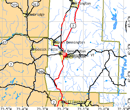
Bennington, Vermont
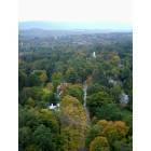
Bennington: View from Bennington Battle Monument
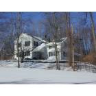
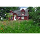
Bennington: A home in Old Bennington
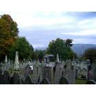
Bennington: Cemetery, Old First Church

Bennington: Bennington Battle Monument

Bennington: View to the West
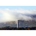
Bennington: Benninton Battle Monument
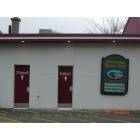
Bennington: Hemmings Service Station in Bennington, VT

Bennington: The Courthouse - looming imposingly, 07/05/13
Bennington: Chamber of Commerce- 07/05/13 - charming set in the background in a garden of wildflowers

Bennington: Henry Bridge - One of Five Covered Bridges in Bennington County
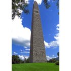
Bennington: The Battle Monument - 07/05/13
- see
14
more - add
your
Submit your own pictures of this place and show them to the world
- OSM Map
- General Map
- Google Map
- MSN Map
Population change since 2000: -1.0%
| Males: 4,271 | |
| Females: 4,803 |
| Median resident age: | 46.5 years |
| Vermont median age: | 43.2 years |
Zip codes: 05201.
| Bennington: | $51,205 |
| VT: | $73,991 |
Estimated per capita income in 2022: $33,595 (it was $16,507 in 2000)
Bennington CDP income, earnings, and wages data
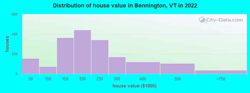
Estimated median house or condo value in 2022: $198,771 (it was $92,700 in 2000)
| Bennington: | $198,771 |
| VT: | $304,700 |
Mean prices in 2022: all housing units: $210,964; detached houses: $218,356; townhouses or other attached units: $163,014; in 2-unit structures: $138,370; in 3-to-4-unit structures: $459,368; mobile homes: $25,655
Median gross rent in 2022: $983.
(14.2% for White Non-Hispanic residents, 100.0% for Black residents, 21.8% for Hispanic or Latino residents, 7.5% for two or more races residents)
Detailed information about poverty and poor residents in Bennington, VT


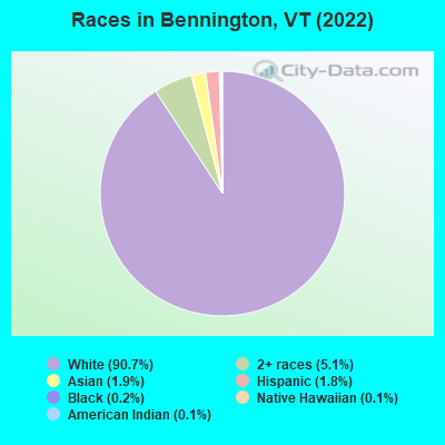
- 7,98290.7%White alone
- 4475.1%Two or more races
- 1711.9%Asian alone
- 1581.8%Hispanic
- 190.2%Black alone
- 90.1%American Indian alone
- 110.1%Native Hawaiian and Other
Pacific Islander alone
Races in Bennington detailed stats: ancestries, foreign born residents, place of birth
According to our research of Vermont and other state lists, there were 81 registered sex offenders living in Bennington, Vermont as of April 27, 2024.
The ratio of all residents to sex offenders in Bennington is 110 to 1.
Type |
2009 |
2010 |
2011 |
2012 |
2013 |
2014 |
2015 |
2016 |
2017 |
2018 |
2019 |
2020 |
2021 |
2022 |
|---|---|---|---|---|---|---|---|---|---|---|---|---|---|---|
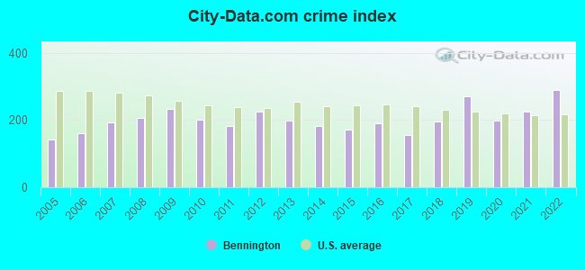
| Murders (per 100,000) | 0 (0.0) | 0 (0.0) | 0 (0.0) | 0 (0.0) | 0 (0.0) | 0 (0.0) | 0 (0.0) | 1 (6.6) | 0 (0.0) | 0 (0.0) | 0 (0.0) | 0 (0.0) | 1 (6.8) | 2 (13.1) |
| Rapes (per 100,000) | 5 (33.3) | 5 (31.7) | 2 (12.7) | 2 (12.7) | 4 (25.8) | 6 (38.8) | 4 (26.1) | 2 (13.1) | 2 (13.1) | 5 (33.6) | 3 (20.1) | 1 (6.7) | 0 (0.0) | 2 (13.1) |
| Robberies (per 100,000) | 5 (33.3) | 2 (12.7) | 1 (6.3) | 3 (19.1) | 2 (12.9) | 4 (25.9) | 6 (39.1) | 9 (59.0) | 1 (6.6) | 4 (26.8) | 9 (60.4) | 9 (60.5) | 4 (27.0) | 7 (45.7) |
| Assaults (per 100,000) | 35 (232.9) | 40 (253.7) | 19 (120.4) | 22 (140.2) | 15 (96.8) | 23 (148.7) | 27 (175.8) | 25 (163.8) | 22 (144.6) | 24 (161.1) | 57 (382.2) | 24 (161.3) | 47 (317.3) | 82 (535.9) |
| Burglaries (per 100,000) | 77 (512.4) | 67 (425.0) | 104 (659.0) | 146 (930.5) | 131 (845.6) | 68 (439.7) | 55 (358.2) | 63 (412.7) | 64 (420.6) | 54 (362.4) | 68 (456.0) | 75 (504.1) | 73 (492.8) | 34 (222.2) |
| Thefts (per 100,000) | 377 (2,509) | 310 (1,967) | 367 (2,326) | 404 (2,575) | 328 (2,117) | 294 (1,901) | 266 (1,732) | 292 (1,913) | 282 (1,853) | 358 (2,403) | 443 (2,971) | 376 (2,527) | 347 (2,342) | 435 (2,843) |
| Auto thefts (per 100,000) | 23 (153.1) | 24 (152.2) | 13 (82.4) | 24 (153.0) | 22 (142.0) | 10 (64.7) | 16 (104.2) | 18 (117.9) | 18 (118.3) | 12 (80.5) | 18 (120.7) | 13 (87.4) | 22 (148.5) | 6 (39.2) |
| Arson (per 100,000) | 1 (6.7) | 5 (31.7) | 0 (0.0) | 2 (12.7) | 4 (25.8) | 1 (6.5) | 1 (6.5) | 0 (0.0) | 0 (0.0) | 0 (0.0) | 0 (0.0) | 2 (13.4) | 1 (6.8) | 1 (6.5) |
| City-Data.com crime index | 231.7 | 200.5 | 181.9 | 224.3 | 199.1 | 180.5 | 170.4 | 188.9 | 154.5 | 195.0 | 271.1 | 199.1 | 225.1 | 289.9 |
The City-Data.com crime index weighs serious crimes and violent crimes more heavily. Higher means more crime, U.S. average is 246.1. It adjusts for the number of visitors and daily workers commuting into cities.
Crime rate in Bennington detailed stats: murders, rapes, robberies, assaults, burglaries, thefts, arson
Full-time law enforcement employees in 2021, including police officers: 31 (24 officers - 22 male; 2 female).
| Officers per 1,000 residents here: | 1.62 |
| Vermont average: | 1.69 |
 Recent articles from our blog. Our writers, many of them Ph.D. graduates or candidates, create easy-to-read articles on a wide variety of topics.

 | Bennington, Vermont: Looks nice. What's the catch? (35 replies) |
| Bennington, Vermont area (14 replies) |
| Taking job in Sunderland: relocation to Bennington area? (5 replies) |
| North Bennington (2 replies) |
| Southern Vermont Retirement Advice! Thank you! (22 replies) |
| Bennington and surrounding area? (6 replies) |
Latest news from Bennington, VT collected exclusively by city-data.com from local newspapers, TV, and radio stations
Ancestries: English (16.7%), Scottish (11.2%), American (10.8%), Italian (9.1%), Irish (8.1%), French (6.9%).
Current Local Time: EST time zone
Elevation: 681 feet
Land area: 4.87 square miles.
Population density: 1,864 people per square mile (low).
173 residents are foreign born
| This place: | 2.0% |
| Vermont: | 4.4% |
Median real estate property taxes paid for housing units with mortgages in 2022: $3,884 (2.0%)
Median real estate property taxes paid for housing units with no mortgage in 2022: $4,456 (2.0%)
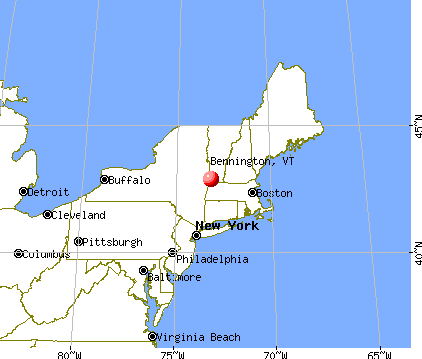
Nearest city with pop. 50,000+: Albany, NY  (33.6 miles , pop. 95,658).
Nearest city with pop. 200,000+: Boston, MA (113.7 miles , pop. 589,141).
Nearest city with pop. 1,000,000+: Bronx, NY (144.9 miles , pop. 1,332,650).
Nearest cities:
), ), ), )Latitude: 42.88 N, Longitude: 73.19 W
Daytime population change due to commuting: +3,195 (+36.3%)
Workers who live and work in this place: 2,256 (58.1%)
Area code: 802
Bennington tourist attractions:
Bennington, Vermont accommodation & food services, waste management - Economy and Business Data
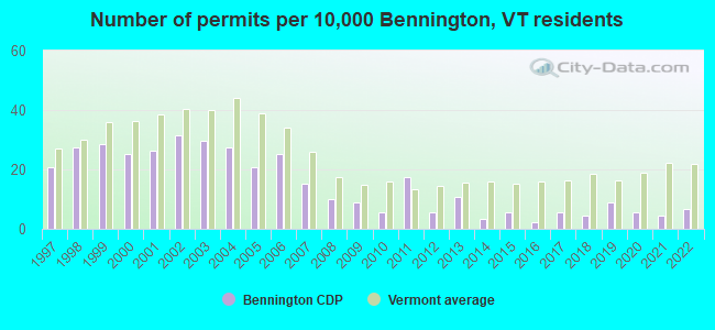
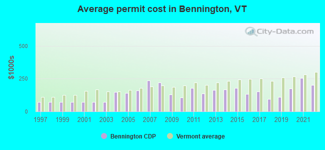
Single-family new house construction building permits:
- 2022: 6 buildings, average cost: $201,700
- 2021: 4 buildings, average cost: $256,300
- 2020: 5 buildings, average cost: $174,600
- 2019: 8 buildings, average cost: $109,900
- 2018: 4 buildings, average cost: $96,000
- 2017: 5 buildings, average cost: $154,000
- 2016: 2 buildings, average cost: $135,000
- 2015: 5 buildings, average cost: $177,600
- 2014: 3 buildings, average cost: $166,700
- 2013: 10 buildings, average cost: $164,300
- 2012: 5 buildings, average cost: $136,400
- 2011: 16 buildings, average cost: $181,300
- 2010: 5 buildings, average cost: $107,200
- 2009: 8 buildings, average cost: $129,900
- 2008: 9 buildings, average cost: $222,300
- 2007: 14 buildings, average cost: $235,500
- 2006: 23 buildings, average cost: $161,700
- 2005: 19 buildings, average cost: $141,100
- 2004: 25 buildings, average cost: $147,700
- 2003: 27 buildings, average cost: $71,200
- 2002: 29 buildings, average cost: $71,200
- 2001: 24 buildings, average cost: $71,200
- 2000: 23 buildings, average cost: $71,200
- 1999: 26 buildings, average cost: $71,200
- 1998: 25 buildings, average cost: $71,100
- 1997: 19 buildings, average cost: $71,700
| Here: | 2.7% |
| Vermont: | 2.0% |
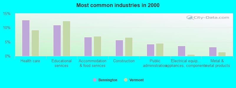
- Health care (12.7%)
- Educational services (11.0%)
- Accommodation & food services (6.7%)
- Construction (5.7%)
- Public administration (4.2%)
- Electrical equipment, appliances, components (3.6%)
- Metal & metal products (3.3%)
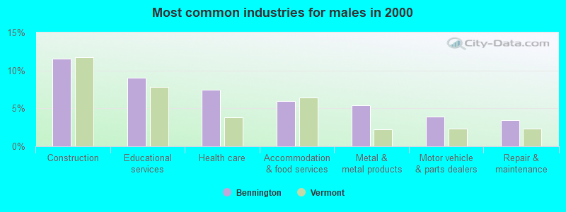
- Construction (11.6%)
- Educational services (9.0%)
- Health care (7.4%)
- Accommodation & food services (5.9%)
- Metal & metal products (5.4%)
- Motor vehicle & parts dealers (3.9%)
- Repair & maintenance (3.4%)
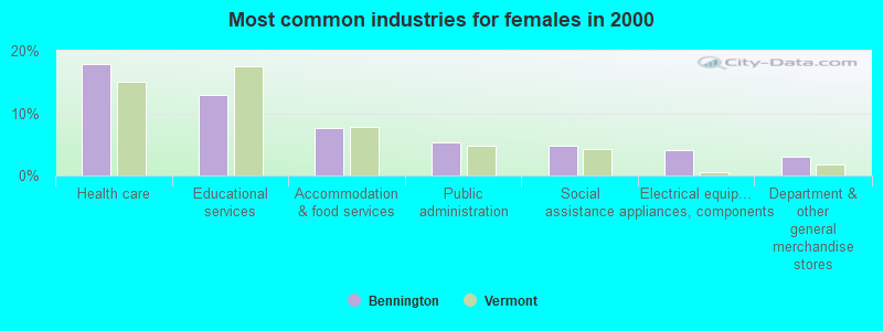
- Health care (17.9%)
- Educational services (12.9%)
- Accommodation & food services (7.5%)
- Public administration (5.3%)
- Social assistance (4.8%)
- Electrical equipment, appliances, components (4.0%)
- Department & other general merchandise stores (3.0%)
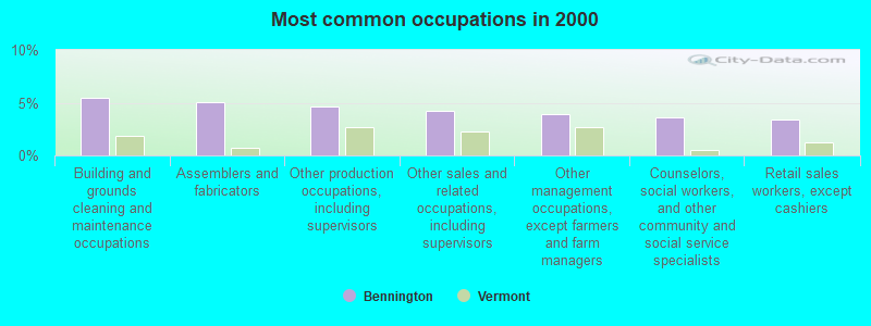
- Building and grounds cleaning and maintenance occupations (5.5%)
- Assemblers and fabricators (5.1%)
- Other production occupations, including supervisors (4.6%)
- Other sales and related occupations, including supervisors (4.2%)
- Other management occupations, except farmers and farm managers (3.9%)
- Counselors, social workers, and other community and social service specialists (3.6%)
- Retail sales workers, except cashiers (3.4%)
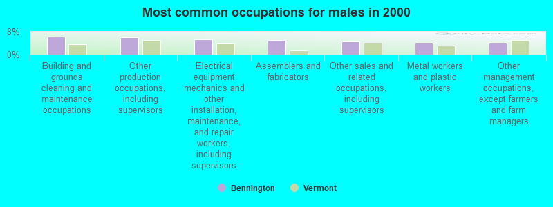
- Building and grounds cleaning and maintenance occupations (6.2%)
- Other production occupations, including supervisors (6.0%)
- Electrical equipment mechanics and other installation, maintenance, and repair workers, including supervisors (5.4%)
- Assemblers and fabricators (5.1%)
- Other sales and related occupations, including supervisors (4.6%)
- Metal workers and plastic workers (4.2%)
- Other management occupations, except farmers and farm managers (4.1%)
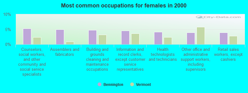
- Counselors, social workers, and other community and social service specialists (5.2%)
- Assemblers and fabricators (5.0%)
- Building and grounds cleaning and maintenance occupations (4.7%)
- Information and record clerks, except customer service representatives (4.5%)
- Health technologists and technicians (4.1%)
- Other office and administrative support workers, including supervisors (3.9%)
- Retail sales workers, except cashiers (3.9%)
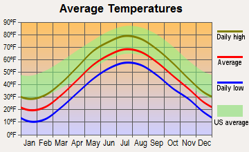
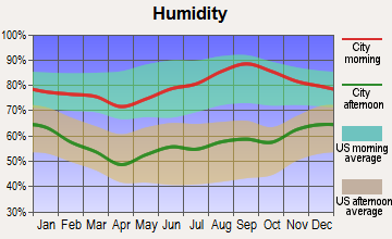
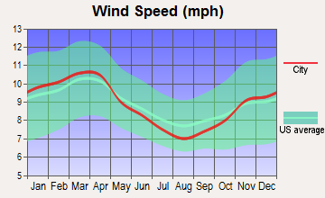
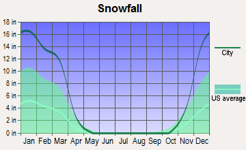
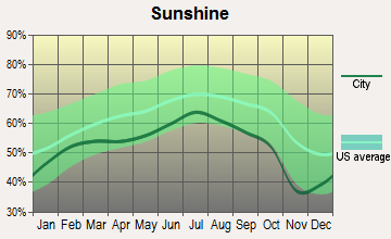
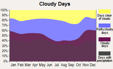
Average climate in Bennington, Vermont
Based on data reported by over 4,000 weather stations
|
|

(lower is better)
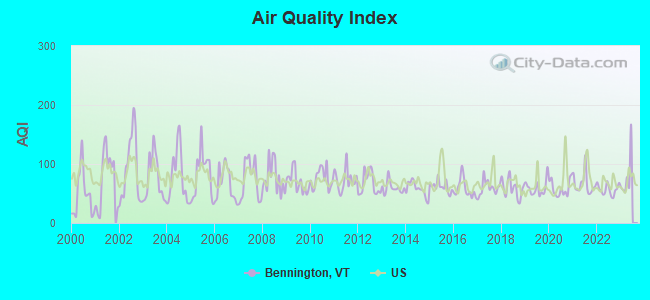
Air Quality Index (AQI) level in 2022 was 56.8. This is better than average.
| City: | 56.8 |
| U.S.: | 72.6 |
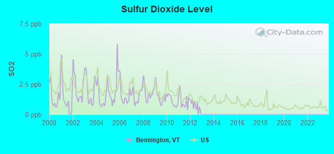
Sulfur Dioxide (SO2) [ppb] level in 2012 was 0.789. This is significantly better than average. Closest monitor was 6.1 miles away from the city center.
| City: | 0.789 |
| U.S.: | 1.515 |
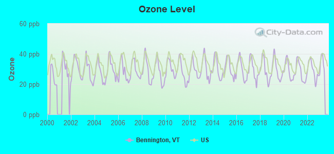
Ozone [ppb] level in 2022 was 29.1. This is about average. Closest monitor was 3.1 miles away from the city center.
| City: | 29.1 |
| U.S.: | 33.3 |
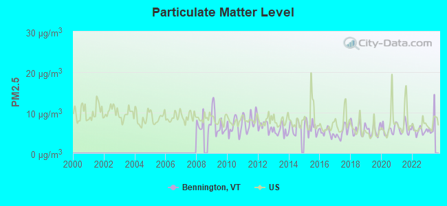
Particulate Matter (PM2.5) [µg/m3] level in 2022 was 5.56. This is significantly better than average. Closest monitor was 0.4 miles away from the city center.
| City: | 5.56 |
| U.S.: | 8.11 |
Tornado activity:
Bennington-area historical tornado activity is significantly above Vermont state average. It is 37% smaller than the overall U.S. average.
On 5/31/1998, a category F3 (max. wind speeds 158-206 mph) tornado 3.6 miles away from the Bennington place center injured 68 people and caused $71 million in damages.
On 8/28/1973, a category F4 (max. wind speeds 207-260 mph) tornado 33.8 miles away from the place center killed 4 people and injured 36 people and caused between $5,000,000 and $50,000,000 in damages.
Earthquake activity:
Bennington-area historical earthquake activity is significantly above Vermont state average. It is 69% smaller than the overall U.S. average.On 10/7/1983 at 10:18:46, a magnitude 5.3 (5.1 MB, 5.3 LG, 5.1 ML, Class: Moderate, Intensity: VI - VII) earthquake occurred 94.2 miles away from the city center
On 4/20/2002 at 10:50:47, a magnitude 5.3 (5.3 ML, Depth: 3.0 mi) earthquake occurred 115.8 miles away from Bennington center
On 4/20/2002 at 10:50:47, a magnitude 5.2 (5.2 MB, 4.2 MS, 5.2 MW, 5.0 MW) earthquake occurred 114.3 miles away from the city center
On 1/19/1982 at 00:14:42, a magnitude 4.7 (4.5 MB, 4.7 MD, 4.5 LG, Class: Light, Intensity: IV - V) earthquake occurred 91.0 miles away from the city center
On 10/16/2012 at 23:12:25, a magnitude 4.7 (4.7 ML, Depth: 10.0 mi) earthquake occurred 137.0 miles away from Bennington center
On 6/17/1991 at 08:53:16, a magnitude 4.1 (4.0 MB, 4.0 LG, Depth: 3.1 mi) earthquake occurred 77.5 miles away from the city center
Magnitude types: regional Lg-wave magnitude (LG), body-wave magnitude (MB), duration magnitude (MD), local magnitude (ML), surface-wave magnitude (MS), moment magnitude (MW)
Natural disasters:
The number of natural disasters in Bennington County (15) is near the US average (15).Major Disasters (Presidential) Declared: 10
Emergencies Declared: 2
Causes of natural disasters: Floods: 8, Storms: 8, Tropical Storms: 2, Winter Storms: 2, Hurricane: 1, Landslide: 1, Snowstorm: 1, Wind: 1, Other: 1 (Note: some incidents may be assigned to more than one category).
Hospitals and medical centers in Bennington:
- SOUTHWESTERN VERMONT MEDICAL CENTER (Voluntary non-profit - Private, 100 HOSPITAL DRIVE)
- BENNINGTON CONVEALESCENT CTR (360 DEWEY ST)
- BENNINGTON HEALTH AND REHAB (2 BLACKBERRY LANE)
- CENTERS FOR LIVING AND REHAB (160 HOSPITAL DRIVE)
- CRESCENT MANOR CARE CTRS (312 CRESCENT BLVD)
- VERMONT VETERANS HOME (325 NORTH STREET)
- SOUTHWESTERN VERMONT RENAL CENTER (SVMC)
- VNA AND HOSPICE OF SVHC (160 BENMONT AVENUE SUITE 17)
Airports and heliports located in Bennington:
- William H Morse State Airport (DDH) (Runways: 1, Itinerant Ops: 8,627, Local Ops: 5,625, Military Ops: 125)
- Southwestern Vermont Heliport (VT04)
Colleges/Universities in Bennington:
Colleges/universities with over 2000 students nearest to Bennington:
- Williams College (about 12 miles; Williamstown, MA; Full-time enrollment: 2,141)
- Rensselaer Polytechnic Institute (about 27 miles; Troy, NY; FT enrollment: 6,940)
- The Sage Colleges (about 28 miles; Troy, NY; FT enrollment: 2,499)
- Hudson Valley Community College (about 28 miles; Troy, NY; FT enrollment: 9,346)
- Siena College (about 31 miles; Loudonville, NY; FT enrollment: 3,153)
- SUNY Empire State College (about 33 miles; Saratoga Springs, NY; FT enrollment: 9,473)
- Skidmore College (about 34 miles; Saratoga Springs, NY; FT enrollment: 2,753)
Public high school in Bennington:
- MT. ANTHONY SENIOR UHSD #14 (Students: 1,193, Location: 301 PARK STREET EXTENSION, Grades: 9-12)
Private high schools in Bennington:
- GRACE CHRISTIAN SCHOOL (Students: 159, Location: 104 KOCHER DR, Grades: PK-12)
- BENNINGTON SCHOOL (Students: 56, Location: 192 FAIRVIEW ST, Grades: 5-12)
- GREEN MT MENNONITE SCHOOL (Students: 17, Location: 2892 CHAPEL RD, Grades: 1-9)
Public elementary/middle schools in Bennington:
- MT. ANTHONY UNION MIDDLE SCHOOL (Students: 565, Location: 747 EAST ROAD, Grades: 6-8)
- MOLLY STARK SCHOOL (Students: 307, Location: 181 ORCHARD STREET, Grades: PK-5)
- MONUMENT SCHOOL (Students: 144, Location: 66 MAIN STREET, Grades: PK-5)
- WOODFORD HOLLOW SCHOOL (Students: 33, Location: 995 VT ROUTE 9, Grades: PK-6)
- BENNINGTON ELEMENTARY SCHOOL (Location: 128 PARK STREET, Grades: PK-5)
Private elementary/middle schools in Bennington:
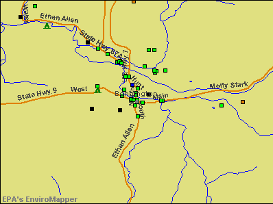
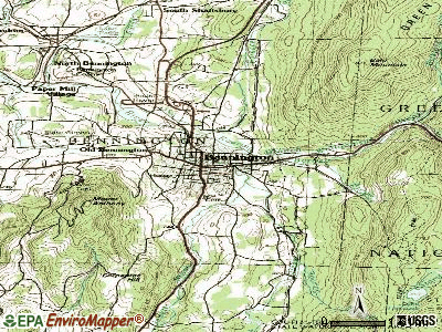
Points of interest:
Notable locations in Bennington: Holden-Leonard Mill Complex (A), Bennington Town Hall (B), Bennington Free Library (C), Bennington County Courthouse (D), Bennington Area Chamber of Commerce (E), Vermont Veterans Home Library (F), Southwestern Vermont Medical Center Medical Library (G), Samuel H Blackmer Memorial Library (H), Bennington Fire Department (I), Bennington Rescue Squad (J), Bennington County Sheriff's Department (K). Display/hide their locations on the map
Shopping Center: North Street Shopping Center (1). Display/hide its location on the map
Churches in Bennington include: First Baptist Church (A), First Church of Christ (B), First United Methodist Church (C), Sacred Heart-Saint Francis Church (D), Saint Peters Episcopal Church (E), Christian and Missionary Alliance Church (F). Display/hide their locations on the map
Cemeteries: Bennington Village Cemetery (1), Park Lawn Cemetery (2), Woodward Cemetery (3), Vermont Veterans Home Cemetery (4). Display/hide their locations on the map
Streams, rivers, and creeks: South Stream (A), Barney Brook (B), Jewett Brook (C). Display/hide their locations on the map
Parks in Bennington include: Downtown Bennington Historic District (1), Memorial Park (2). Display/hide their locations on the map
Tourist attraction: Bennington Battle Monument (Museums; 15 Monument Circle).
Hotels: Bennington Motor Inn (143 Main Street), A Walk In The Woods Motel (5697 Route 9), Autumn Inn (924 Main Street), Catamount Motel (500 South Street), Vermonter Motor Lodge (West Road), Hampton Inn (51 Hannaford Sq), South Shire Inn (124 Elm Street), Darling Kelley's Motel (South Street Ext), Molly Stark Inn (1067 Main Street).
Courts: Vermont State - Corrections Dept- Bennington Community Correctional- Service Center & Court & (Veterans Memorial Drive), Passport Information County Court (207 South Street).
Birthplace of: Anne Lynch Botta - Writer, Cynthia Gibb - Film actor, Hiram Bingham I - Christian missionary, James Fisk (financier) - Railroad executive, Pamela Blair - Dancer, Carleton Carpenter - Actor, Robert Alton - Choreographer, Simon Fraser (explorer), Charles Dewey Day - Judge, Hiland Hall - Politician.
Drinking water stations with addresses in Bennington and their reported violations in the past:
BENNINGTON WATER DEPT (Address: 205 SOUTH ST , Population served: 13,250, Surface water):Past health violations:APPLEGATE APARTMENTS (Address: 89 APPLEGATE DR , Population served: 273, Purch surface water):Past monitoring violations:
- Treatment Technique (SWTR and GWR) - In OCT-2007. Follow-up actions: St Public Notif requested (NOV-27-2007), St Formal NOV issued (NOV-27-2007), St Public Notif received (DEC-17-2007), St Compliance achieved (MAR-31-2010)
- MCL, Average - Between APR-2007 and JUN-2007, Contaminant: Total Haloacetic Acids (HAA5). Follow-up actions: St Public Notif received (JUN-18-2007), St Public Notif requested (SEP-18-2007), St Formal NOV issued (SEP-18-2007), St Compliance achieved (MAR-24-2010)
- MCL, Average - Between JAN-2007 and MAR-2007, Contaminant: Total Haloacetic Acids (HAA5). Follow-up actions: St Public Notif requested (JUN-11-2007), St Formal NOV issued (JUN-11-2007), St Public Notif received (JUN-14-2007), St Compliance achieved (MAR-24-2010)
- MCL, Average - Between OCT-2006 and DEC-2006, Contaminant: Total Haloacetic Acids (HAA5). Follow-up actions: St Public Notif requested (JAN-11-2007), St Formal NOV issued (JAN-11-2007), St Public Notif received (FEB-06-2007), St Compliance achieved (MAR-24-2010)
- MCL, Average - Between JUL-2006 and SEP-2006, Contaminant: Total Haloacetic Acids (HAA5). Follow-up actions: St Public Notif requested (OCT-17-2006), St Formal NOV issued (OCT-17-2006), St Public Notif received (NOV-16-2006), St Compliance achieved (MAR-24-2010)
- MCL, Average - Between APR-2006 and JUN-2006, Contaminant: Total Haloacetic Acids (HAA5). Follow-up actions: St Public Notif requested (AUG-07-2006), St Formal NOV issued (AUG-07-2006), St Public Notif received (AUG-14-2006), St Compliance achieved (MAR-24-2010)
- 4 other older health violations
- Monitoring and Reporting (DBP) - Between OCT-2008 and DEC-2008, Contaminant: Total Haloacetic Acids (HAA5). Follow-up actions: St Public Notif requested (MAR-24-2009), St Tech Assistance Visit (MAR-24-2009), St Formal NOV issued (MAR-24-2009), St Public Notif received (JUN-03-2009), St Compliance achieved (2 times from SEP-02-2009 to MAR-24-2010)
- Monitoring and Reporting (DBP) - Between OCT-2008 and DEC-2008, Contaminant: TTHM. Follow-up actions: St Public Notif requested (MAR-24-2009), St Tech Assistance Visit (MAR-24-2009), St Formal NOV issued (MAR-24-2009), St Public Notif received (JUN-03-2009), St Compliance achieved (2 times from SEP-02-2009 to MAR-24-2010)
Past health violations:THE PUBLIC HOUSE (Address: 782 HARWOOD HILL RD , Population served: 185, Groundwater):Past monitoring violations:
- MCL, Average - Between APR-2007 and JUN-2007, Contaminant: Total Haloacetic Acids (HAA5). Follow-up actions: St Public Notif requested (SEP-19-2007), St Formal NOV issued (SEP-19-2007), St Compliance achieved (JUL-16-2010)
- MCL, Average - Between JAN-2007 and MAR-2007, Contaminant: Total Haloacetic Acids (HAA5). Follow-up actions: St Public Notif requested (JUN-11-2007), St Formal NOV issued (JUN-11-2007), St Compliance achieved (2 times from JUL-16-2010 to JUL-16-2010)
- MCL, Average - Between OCT-2006 and DEC-2006, Contaminant: Total Haloacetic Acids (HAA5). Follow-up actions: St Public Notif requested (JAN-22-2007), St Formal NOV issued (JAN-22-2007), St Compliance achieved (2 times from JUL-16-2010 to JUL-16-2010)
- MCL, Average - Between JUL-2006 and SEP-2006, Contaminant: Total Haloacetic Acids (HAA5). Follow-up actions: St Public Notif requested (NOV-13-2006), St Formal NOV issued (NOV-13-2006), St Public Notif received (DEC-01-2006)
- MCL, Average - Between APR-2006 and JUN-2006, Contaminant: Total Haloacetic Acids (HAA5). Follow-up actions: St Public Notif requested (AUG-09-2006), St Formal NOV issued (AUG-09-2006), St Compliance achieved (JUL-16-2010)
- MCL, Average - Between JAN-2006 and MAR-2006, Contaminant: Total Haloacetic Acids (HAA5). Follow-up actions: St Public Notif requested (APR-25-2006), St Formal NOV issued (APR-25-2006), St Public Notif received (MAY-05-2006), St Compliance achieved (2 times from JUL-16-2010 to JUL-16-2010)
- MCL, Average - Between APR-2005 and JUN-2005, Contaminant: Total Haloacetic Acids (HAA5). Follow-up actions: St Formal NOV issued (NOV-01-2005), St Public Notif requested (NOV-01-2005), St Public Notif received (NOV-10-2005), St Compliance achieved (2 times from JUL-16-2010 to JUL-16-2010)
- Monitoring and Reporting (DBP) - Between APR-2009 and JUN-2009, Contaminant: Chlorine. Follow-up actions: St Public Notif requested (SEP-01-2009), St Formal NOV issued (SEP-01-2009), St Public Notif received (SEP-15-2009), St Compliance achieved (AUG-18-2010)
- Monitoring and Reporting (DBP) - Between JUL-2008 and SEP-2008, Contaminant: Chlorine. Follow-up actions: St Public Notif requested (APR-07-2009), St Formal NOV issued (APR-07-2009), St Public Notif received (NOV-09-2009), St Compliance achieved (AUG-18-2010)
- Monitoring and Reporting (DBP) - Between OCT-2006 and DEC-2006, Contaminant: Total Haloacetic Acids (HAA5). Follow-up actions: St Formal NOV issued (FEB-27-2007), St Public Notif requested (FEB-27-2007)
- Monitoring and Reporting (DBP) - Between OCT-2006 and DEC-2006, Contaminant: TTHM. Follow-up actions: St Formal NOV issued (FEB-27-2007), St Public Notif requested (FEB-27-2007)
- Monitoring and Reporting (DBP) - Between JUL-2004 and JAN-2005, Contaminant: Total Haloacetic Acids (HAA5). Follow-up actions: St Public Notif requested (DEC-02-2004), St Formal NOV issued (DEC-02-2004), St Compliance achieved (APR-05-2005)
- 3 routine major monitoring violations
Past monitoring violations:NEW ENGLANDER MOTOR INN (Address: 220 NORTHSIDE DR , Population served: 178, Groundwater):
- 7 routine major monitoring violations
- 3 regular monitoring violations
Past monitoring violations:WEST ROAD MOTEL (Address: 924 MAIN ST , Population served: 151, Groundwater):
- One routine major monitoring violation
Past health violations:VISHAY TANSITOR (Address: 2813 WEST RD , Population served: 130, Groundwater):Past monitoring violations:
- MCL, Monthly (TCR) - In SEP-2008, Contaminant: Coliform. Follow-up actions: St Tech Assistance Visit (OCT-02-2008), St Formal NOV issued (OCT-02-2008), St Public Notif requested (OCT-02-2008), St Boil Water Order (OCT-02-2008), State No Longer Subject to Rule (MAY-10-2012)
- Monitoring, Repeat Major (TCR) - Between APR-2010 and JUN-2010, Contaminant: Coliform (TCR). Follow-up actions: St Public Notif requested (AUG-03-2010), St Formal NOV issued (AUG-03-2010), St Compliance achieved (JAN-26-2012)
- 12 routine major monitoring violations
- 3 minor monitoring violations
- 2 regular monitoring violations
Past monitoring violations:EAST MOUNTAIN MHP (Address: 2557 NATHAN DR , Population served: 76, Purch surface water):
- Follow-up Or Routine LCR Tap M/R - In OCT-01-2010, Contaminant: Lead and Copper Rule. Follow-up actions: St Formal NOV issued (DEC-29-2010), St Tech Assistance Visit (DEC-29-2010), St Public Notif requested (DEC-29-2010), St Public Notif received (JAN-18-2011)
- Monitoring and Reporting (DBP) - Between JUL-2008 and SEP-2008, Contaminant: Chlorine. Follow-up actions: St Public Notif requested (APR-07-2009), St Formal NOV issued (APR-07-2009), St Public Notif received (JUL-01-2009), St Compliance achieved (MAR-08-2011)
- 2 routine major monitoring violations
Past health violations:STARLIGHT INN (Address: 357 US ROUTE 7 SOUTH , Population served: 73, Groundwater):Past monitoring violations:
- MCL, Average - Between JAN-2008 and MAR-2008, Contaminant: TTHM. Follow-up actions: St Public Notif requested (JUN-09-2008), St Formal NOV issued (JUN-09-2008), St Compliance achieved (NOV-04-2010)
- MCL, Average - Between OCT-2007 and DEC-2007, Contaminant: TTHM. Follow-up actions: St Public Notif requested (DEC-07-2007), St Formal NOV issued (DEC-07-2007), St Compliance achieved (NOV-04-2010)
- Monitoring and Reporting (DBP) - Between JAN-2014 and MAR-2014, Contaminant: Chlorine. Follow-up actions: St Public Notif requested (FEB-13-2014), St Formal NOV issued (FEB-13-2014), St Compliance achieved (MAR-20-2014)
- Monitoring and Reporting (DBP) - Between JUL-2013 and SEP-2013, Contaminant: Chlorine. Follow-up actions: St Public Notif requested (OCT-30-2013), St Formal NOV issued (OCT-30-2013), St Compliance achieved (NOV-14-2013)
- Monitoring and Reporting (DBP) - Between JUL-2013 and SEP-2013, Contaminant: Total Haloacetic Acids (HAA5). Follow-up actions: St Formal NOV issued (NOV-26-2013), St Public Notif requested (NOV-26-2013), St Tech Assistance Visit (NOV-26-2013)
- Monitoring and Reporting (DBP) - Between JUL-2013 and SEP-2013, Contaminant: TTHM. Follow-up actions: St Formal NOV issued (NOV-26-2013), St Public Notif requested (NOV-26-2013), St Tech Assistance Visit (NOV-26-2013)
- Monitoring and Reporting (DBP) - Between APR-2012 and JUN-2012, Contaminant: Chlorine. Follow-up actions: St Public Notif requested (JUN-27-2012), St Formal NOV issued (JUN-27-2012), St Compliance achieved (MAR-15-2013)
- 8 routine major monitoring violations
- 3 minor monitoring violations
- 20 other older monitoring violations
Past monitoring violations:
- One routine major monitoring violation
Drinking water stations with addresses in Bennington that have no violations reported:
- GREENWOOD LODGE AND CAMPSITES (Population served: 185, Primary Water Source Type: Groundwater)
- HARWOOD HILL MOTEL (Address: 864 HARWOOD HILL RD , Population served: 47, Primary Water Source Type: Groundwater)
- HATHAWAY DRIVE IN (Serves NY, Population served: 25, Primary Water Source Type: Groundwater)
| This place: | 2.2 people |
| Vermont: | 2.3 people |
| This place: | 56.0% |
| Whole state: | 62.5% |
| This place: | 10.9% |
| Whole state: | 9.2% |
Likely homosexual households (counted as self-reported same-sex unmarried-partner households)
- Lesbian couples: 0.7% of all households
- Gay men: 0.2% of all households
People in group quarters in Bennington in 2010:
- 452 people in nursing facilities/skilled-nursing facilities
- 63 people in group homes intended for adults
- 17 people in other noninstitutional facilities
- 15 people in emergency and transitional shelters (with sleeping facilities) for people experiencing homelessness
- 5 people in group homes for juveniles (non-correctional)
People in group quarters in Bennington in 2000:
- 476 people in nursing homes
- 19 people in other noninstitutional group quarters
- 16 people in unknown juvenile institutions
- 14 people in other group homes
- 4 people in homes for the mentally retarded
Banks with branches in Bennington (2011 data):
- The Bank of Bennington: Phyllis Lane Branch at 32 Phyllis Lane, branch established on 2011/03/21; The Bank Of Bennington at 155 North Street, branch established on 1917/01/01. Info updated 2011/07/21: Bank assets: $304.0 mil, Deposits: $197.1 mil, local headquarters, positive income, Mortgage Lending Specialization, 4 total offices
- People's United Bank: Bennington Branch at 401 Main Street, branch established on 1878/01/01; Bennington Square Branch at 101 Kocher Drive, branch established on 1979/05/07. Info updated 2012/02/16: Bank assets: $27,319.3 mil, Deposits: $20,835.4 mil, headquarters in Bridgeport, CT, positive income, Commercial Lending Specialization, 374 total offices
- Merchants Bank: Putnam Square Branch at 406 Main Street, branch established on 1973/12/26. Info updated 2011/12/09: Bank assets: $1,615.1 mil, Deposits: $1,179.4 mil, headquarters in Burlington, VT, positive income, Commercial Lending Specialization, 34 total offices, Holding Company: Merchants Bancshares, Inc.
- RBS Citizens, National Association: Bennington Main Street Branch at 310 Main Street, branch established on 1938/07/14. Info updated 2007/09/19: Bank assets: $106,940.6 mil, Deposits: $75,690.2 mil, headquarters in Providence, RI, positive income, 1135 total offices, Holding Company: Uk Financial Investments Limited
- TrustCo Bank: Bennington Office at 215 North Street, branch established on 2002/11/15. Info updated 2011/07/21: Bank assets: $4,250.1 mil, Deposits: $3,736.0 mil, headquarters in Glenville, NY, positive income, Mortgage Lending Specialization, 135 total offices
- TD Bank, National Association: Bennington Branch at 500 Main Street, branch established on 1955/12/31. Info updated 2010/10/04: Bank assets: $188,912.6 mil, Deposits: $153,149.8 mil, headquarters in Wilmington, DE, positive income, 1314 total offices, Holding Company: Toronto-Dominion Bank, The
For population 15 years and over in Bennington:
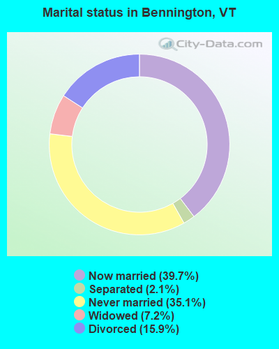
- Never married: 35.1%
- Now married: 39.7%
- Separated: 2.1%
- Widowed: 7.2%
- Divorced: 15.9%
For population 25 years and over in Bennington:
- High school or higher: 91.8%
- Bachelor's degree or higher: 33.1%
- Graduate or professional degree: 15.1%
- Unemployed: 5.6%
- Mean travel time to work (commute): 16.1 minutes
| Here: | 10.6 |
| Vermont average: | 10.8 |
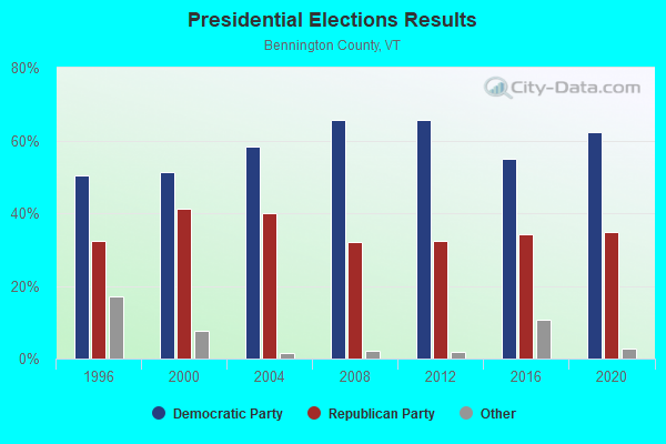
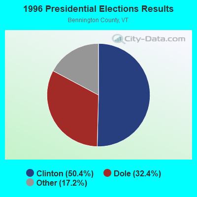
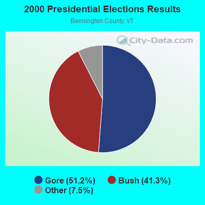
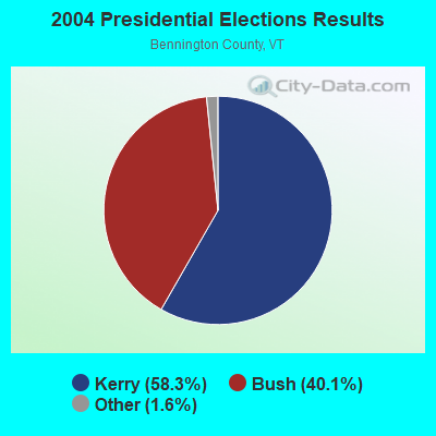
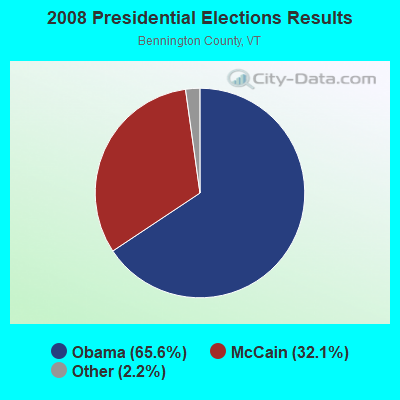
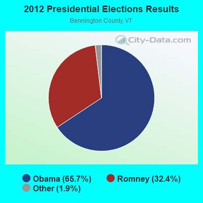
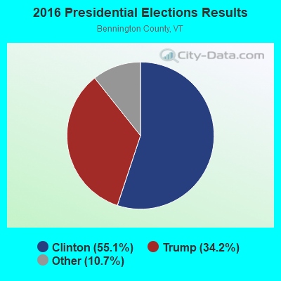
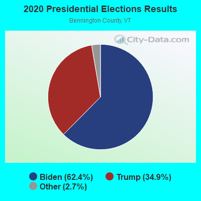
Graphs represent county-level data. Detailed 2008 Election Results
Religion statistics for Bennington, VT (based on Bennington County data)

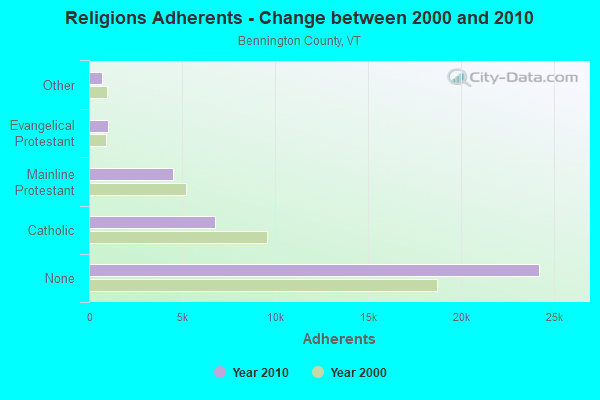
| Religion | Adherents | Congregations |
|---|---|---|
| Catholic | 6,742 | 8 |
| Mainline Protestant | 4,490 | 26 |
| Evangelical Protestant | 1,005 | 12 |
| Other | 693 | 5 |
| None | 24,195 | - |
Food Environment Statistics:
| Bennington County: | 3.85 / 10,000 pop. |
| Vermont: | 3.84 / 10,000 pop. |
| Bennington County: | 3.30 / 10,000 pop. |
| Vermont: | 1.95 / 10,000 pop. |
| Bennington County: | 5.77 / 10,000 pop. |
| State: | 6.40 / 10,000 pop. |
| Here: | 16.48 / 10,000 pop. |
| State: | 11.52 / 10,000 pop. |
| This county: | 8.4% |
| Vermont: | 6.8% |
| Bennington County: | 22.9% |
| Vermont: | 22.3% |
| This county: | 11.6% |
| State: | 13.3% |
Health and Nutrition:
| This city: | 55.2% |
| State: | 52.9% |
| This city: | 54.0% |
| Vermont: | 51.9% |
| This city: | 28.4 |
| Vermont: | 28.4 |
| This city: | 19.9% |
| State: | 21.2% |
| Bennington: | 10.3% |
| Vermont: | 8.8% |
| Bennington: | 7.0 |
| Vermont: | 6.9 |
| Bennington: | 35.0% |
| Vermont: | 34.9% |
| This city: | 60.8% |
| State: | 59.7% |
| This city: | 78.7% |
| Vermont: | 79.6% |
More about Health and Nutrition of Bennington, VT Residents
| Businesses in Bennington, VT | ||||
| Name | Count | Name | Count | |
|---|---|---|---|---|
| ALDI | 1 | Maurices | 1 | |
| AT&T | 1 | McDonald's | 1 | |
| Advance Auto Parts | 1 | New Balance | 1 | |
| Best Western | 1 | Nike | 1 | |
| Blockbuster | 1 | Nissan | 1 | |
| Burger King | 1 | Payless | 1 | |
| CVS | 1 | Penske | 1 | |
| Chevrolet | 1 | Pizza Hut | 1 | |
| Curves | 1 | Quiznos | 1 | |
| Domino's Pizza | 1 | RadioShack | 1 | |
| Dunkin Donuts | 2 | Rite Aid | 1 | |
| FedEx | 2 | SAS Shoes | 1 | |
| Ford | 1 | Sears | 1 | |
| Goodwill | 6 | Sprint Nextel | 1 | |
| H&R Block | 1 | Staples | 1 | |
| Hilton | 1 | Subaru | 1 | |
| Home Depot | 1 | Subway | 2 | |
| Honda | 1 | Taco Bell | 1 | |
| Hyundai | 1 | Toyota | 1 | |
| JCPenney | 1 | U-Haul | 1 | |
| KFC | 1 | U.S. Cellular | 1 | |
| Kmart | 1 | UPS | 2 | |
| Knights Inn | 1 | Vans | 2 | |
| La-Z-Boy | 1 | Walmart | 1 | |
| MasterBrand Cabinets | 1 | Wendy's | 1 | |
Strongest AM radio stations in Bennington:
- WBTN (1370 AM; 1 kW; BENNINGTON, VT; Owner: SOUTHERN VERMONT COLLEGE)
- WGY (810 AM; 50 kW; SCHENECTADY, NY; Owner: CLEAR CHANNEL BROADCASTING LICENSES, INC.)
- WPTR (1540 AM; 50 kW; ALBANY, NY; Owner: KIMTRON, INC.)
- WNNZ (640 AM; 50 kW; WESTFIELD, MA; Owner: CLEAR CHANNEL BROADCASTING LICENSES, INC.)
- WCRN (830 AM; 50 kW; WORCESTER, MA; Owner: CARTER BROADCASTING CORPORATION)
- WTIC (1080 AM; 50 kW; HARTFORD, CT; Owner: INFINITY RADIO OPERATIONS INC.)
- WRKO (680 AM; 50 kW; BOSTON, MA; Owner: ENTERCOM BOSTON LICENSE, LLC)
- WABY (1160 AM; 5 kW; MECHANICVILLE, NY; Owner: ANASTOS MEDIA GROUP, INC.)
- WVNE (760 AM; daytime; 25 kW; LEICESTER, MA; Owner: BLOUNT MASSCOM, INC.)
- WROW (590 AM; 5 kW; ALBANY, NY; Owner: 6 JOHNSON ROAD LICENSES, INC.)
- WIZZ (1520 AM; daytime; 10 kW; GREENFIELD, MA; Owner: P. & M. RADIO, LLC)
- WEEI (850 AM; 50 kW; BOSTON, MA; Owner: ENTERCOM BOSTON LICENSE, LLC)
- WUHN (1110 AM; daytime; 5 kW; PITTSFIELD, MA; Owner: WEINER BROADCASTING, INC.)
Strongest FM radio stations in Bennington:
- W253AF (98.5 FM; BENNINGTON, VT; Owner: NORTHEAST GOSPEL BROADCASTING, INC.)
- WAMC-FM (90.3 FM; ALBANY, NY; Owner: WAMC)
- WEQX (102.7 FM; MANCHESTER, VT; Owner: NORTHSHIRE COMMUNICATIONS, INC.)
- WJAN (95.1 FM; SUNDERLAND, VT; Owner: 6 JOHNSON ROAD LICENSES, INC.)
- WVAY (100.7 FM; WILMINGTON, VT; Owner: GREAT NORTHERN RADIO, L.L.C.)
- WZEC (97.5 FM; HOOSICK FALLS, NY; Owner: GREAT NORTHERN RADIO, LLC)
- WMNB (100.1 FM; NORTH ADAMS, MA; Owner: BERKSHIRE BROADCASTING CO., INC.)
- WNGN (91.9 FM; ARGYLE, NY; Owner: NORTHEAST GOSPEL BROADCASTING INC)
- WBTN-FM (94.3 FM; BENNINGTON, VT; Owner: VERMONT PUBLIC RADIO)
- WJJR (98.1 FM; RUTLAND, VT; Owner: 6 JOHNSON ROAD LICENSES, INC.)
- WZRT (97.1 FM; RUTLAND, VT; Owner: CAPSTAR TX LIMITED PARTNERSHIP)
- WEBK (105.3 FM; KILLINGTON, VT; Owner: 6 JOHNSON ROAD LICENSES, INC.)
- WGLV (91.7 FM; WOODSTOCK, VT; Owner: CHRISTIAN MINISTRIES INC)
- WHDQ-FM1 (106.1 FM; RUTLAND, VT; Owner: GREAT NORTHERN RADIO, L.L.C.)
- WVPR (89.5 FM; WINDSOR, VT; Owner: VERMONT PUBLIC RADIO)
- WHDQ (106.1 FM; CLAREMONT, NH; Owner: GREAT NORTHERN RADIO, L.L.C.)
- WRSY (101.5 FM; MARLBORO, VT; Owner: GREAT NORTHERN RADIO, L.L.C.)
- WCMK (91.9 FM; PUTNEY, VT; Owner: CHRISTIAN MINISTRIES INC)
- WKBE (100.3 FM; WARRENSBURG, NY; Owner: 6 JOHNSON ROAD LICENSES, INC.)
- WKVT-FM (92.7 FM; BRATTLEBORO, VT; Owner: SAGA COMMUNICATIONS OF NEW ENGLAND, LLC)
TV broadcast stations around Bennington:
- W53AS (Channel 53; POWNAL, ETC., VT; Owner: VERMONT ETV, INC.)
- WNGN-LP (Channel 26; TROY, NY; Owner: BRIAN A. LARSON)
- WCDC-TV (Channel 19; ADAMS, MA; Owner: YOUNG BROADCASTING OF ALBANY, INC.)
- WNYA-CA (Channel 39; EASTON, ETC., NY; Owner: VENTURE TECHNOLOGIES GROUP, LLC)
- W38DL (Channel 38; ADAMS, ETC., MA; Owner: WNYT-TV, LLC)
- National Bridge Inventory (NBI) Statistics
- 46Number of bridges
- 509ft / 155mTotal length
- $31,028,000Total costs
- 207,295Total average daily traffic
- 13,507Total average daily truck traffic
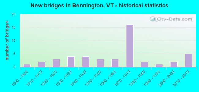
- New bridges - historical statistics
- 11900-1909
- 21910-1919
- 31920-1929
- 41930-1939
- 41940-1949
- 31950-1959
- 31960-1969
- 161970-1979
- 21980-1989
- 11990-1999
- 22000-2009
- 52010-2019
FCC Registered Antenna Towers: 63 (See the full list of FCC Registered Antenna Towers)
FCC Registered Commercial Land Mobile Towers: 1 (See the full list of FCC Registered Commercial Land Mobile Towers in Bennington, VT)
FCC Registered Private Land Mobile Towers: 1 (See the full list of FCC Registered Private Land Mobile Towers)
FCC Registered Broadcast Land Mobile Towers: 17 (See the full list of FCC Registered Broadcast Land Mobile Towers)
FCC Registered Microwave Towers: 10 (See the full list of FCC Registered Microwave Towers in this town)
FCC Registered Paging Towers: 1 (See the full list of FCC Registered Paging Towers)
FCC Registered Maritime Coast & Aviation Ground Towers: 4 (See the full list of FCC Registered Maritime Coast & Aviation Ground Towers)
FCC Registered Amateur Radio Licenses: 137 (See the full list of FCC Registered Amateur Radio Licenses in Bennington)
FAA Registered Aircraft: 19 (See the full list of FAA Registered Aircraft in Bennington)
2002 - 2018 National Fire Incident Reporting System (NFIRS) incidents
- Fire incident types reported to NFIRS in Bennington, VT
- 43555.6%Structure Fires
- 16521.1%Outside Fires
- 10112.9%Mobile Property/Vehicle Fires
- 8210.5%Other
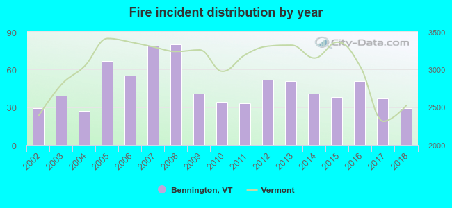 According to the data from the years 2002 - 2018 the average number of fire incidents per year is 46. The highest number of reported fires - 80 took place in 2008, and the least - 27 in 2004. The data has a constant trend.
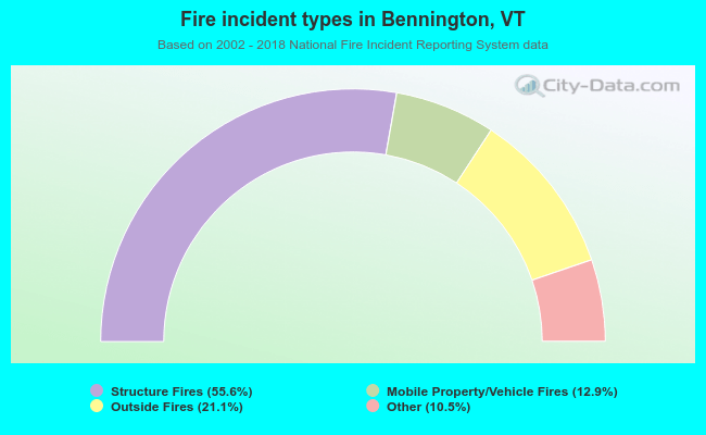 When looking into fire subcategories, the most incidents belonged to: Structure Fires (55.6%), and Outside Fires (21.1%).
Fire-safe hotels and motels in Bennington, Vermont:
- Best Western Plus New Englander Motor Inn, 220 Northside Dr, Bennington, Vermont 05201 , Phone: (802) 442-6311, Fax: (802) 442-5885
- Hampton Inn Bennington, 51 Hannaford Sq, Bennington, Vermont 05201 , Phone: (802) 440-9862, Fax: (802) 440-9864
- Americas Best Value Inn, 357 Us Rt 7 S, BENNINGTON, Vermont 05201 , Phone: (802) 442-2322, Fax: (802) 447-3688
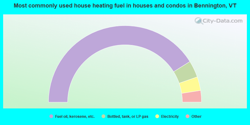
- 82.3%Fuel oil, kerosene, etc.
- 7.1%Bottled, tank, or LP gas
- 5.8%Electricity
- 3.2%Wood
- 1.2%Utility gas
- 0.4%Other fuel
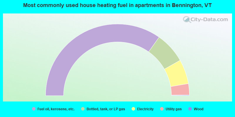
- 69.7%Fuel oil, kerosene, etc.
- 14.0%Bottled, tank, or LP gas
- 11.0%Electricity
- 5.1%Utility gas
- 0.3%Wood
Bennington compared to Vermont state average:
- Median house value below state average.
- Unemployed percentage below state average.
- Black race population percentage significantly below state average.
- Foreign-born population percentage significantly below state average.
- Renting percentage above state average.
- Length of stay since moving in above state average.
- Institutionalized population percentage significantly above state average.

|
|
Total of 27 patent applications in 2008-2024.