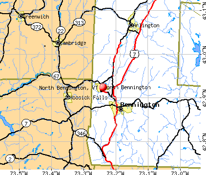
North Bennington, Vermont
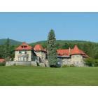
North Bennington: Southern Vermont College is housed in the Everett Mansion, which was built between 1911 and 1914 by business entrepreneur Edward H. Everett as a summer home. The Everett Estate consists of 371 private acres in historic Bennington, Vermont.
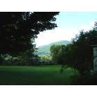
North Bennington: A mountain view from historic Bennington, VT
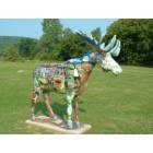
North Bennington: The moose is a motif throughout Bennington, Vermont. This one stands near the entrance of Southern Vermont College.
- add
your
Submit your own pictures of this village and show them to the world
- OSM Map
- General Map
- Google Map
- MSN Map
Population change since 2000: +20.0%
| Males: 822 | |
| Females: 891 |
| Median resident age: | 36.2 years |
| Vermont median age: | 43.2 years |
Zip codes: 05257.
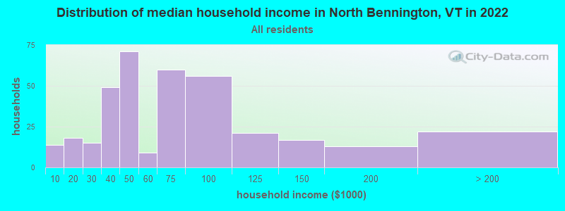
| North Bennington: | $62,106 |
| VT: | $73,991 |
Estimated per capita income in 2022: $26,682 (it was $16,832 in 2000)
North Bennington village income, earnings, and wages data
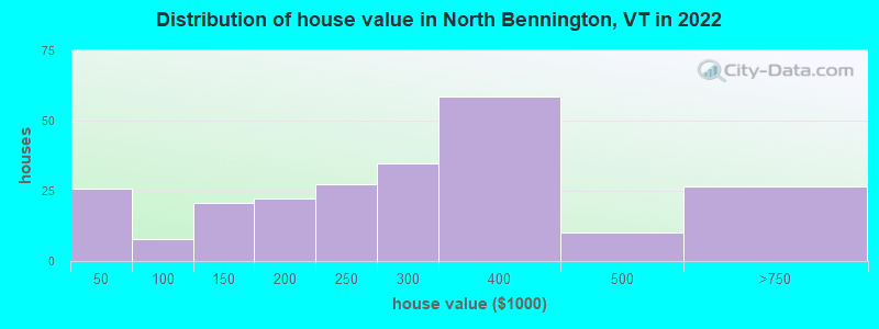
Estimated median house or condo value in 2022: $281,210 (it was $108,900 in 2000)
| North Bennington: | $281,210 |
| VT: | $304,700 |
Mean prices in 2022: all housing units: $328,619; detached houses: $344,818; townhouses or other attached units: $277,995; in 2-unit structures: $228,670; in 3-to-4-unit structures: $413,467; in 5-or-more-unit structures: $239,659; mobile homes: $88,728
Median gross rent in 2022: $1,413.
North Bennington, VT residents, houses, and apartments details
(5.3% for White Non-Hispanic residents, 100.0% for Black residents, 70.2% for two or more races residents)
Detailed information about poverty and poor residents in North Bennington, VT


Compare current foreclosures near North Bennington, VT:
| Photo | Address | Area | Beds / Baths | Price | Details |
|---|---|---|---|---|---|

|
#1
Tinkham Rd
North Bennington, VT 05257
|
- sq. feet
|
- baths - beds |
show details | |

|
#2
Route 7a 3370
Manchester, VT 05254
|
1,800 sq. feet
|
2 baths 2 beds |
$329,900
|
show details |

|
#3
Chapel Rd
Bennington, VT 05201
|
1,000 sq. feet
|
1 baths 2 beds |
$273,000
|
show details |

|
#4
Franklin St
North Adams, MA 01247
|
1,386 sq. feet
|
1 baths 3 beds |
show details | |

|
#5
Barbour St
North Adams, MA 01247
|
1,224 sq. feet
|
1 baths 2 beds |
show details | |

|
#6
North St
North Adams, MA 01247
|
1,164 sq. feet
|
1 baths 3 beds |
show details | |

|
#7
Linden St
Williamstown, MA 01267
|
2,298 sq. feet
|
3 baths 4 beds |
show details | |

|
#8
Hill Hollow Rd
Petersburg, NY 12138
|
980 sq. feet
|
1 baths 1 beds |
show details | |

|
#9
Varville Rd
Petersburg, NY 12138
|
1,232 sq. feet
|
1 baths 3 beds |
show details | |

|
#10
Johnsonville Rd
Johnsonville, NY 12094
|
2,072 sq. feet
|
2 baths 4 beds |
show details |
| Photo | Address | Area | Beds / Baths | Price | Details |
|---|---|---|---|---|---|

|
#11
North St
Williamstown, MA 01267
|
1,552 sq. feet
|
2 baths 3 beds |
show details | |

|
#12
Akin Rd
Johnsonville, NY 12094
|
2,070 sq. feet
|
2 baths 4 beds |
show details | |

|
#13
Linden St
Williamstown, MA 01267
|
2,298 sq. feet
|
3 baths 4 beds |
show details | |

|
#14
Cranberry Pond Rd
Cropseyville, NY 12052
|
1,152 sq. feet
|
1 baths 2 beds |
show details | |

|
#15
Woodlawn Dr
Williamstown, MA 01267
|
1,806 sq. feet
|
2 baths 4 beds |
show details | |

|
#16
Franklin St
North Adams, MA 01247
|
1,386 sq. feet
|
1 baths 3 beds |
show details | |

|
#17
Wright Rd
Cambridge, NY 12816
|
1,620 sq. feet
|
2 baths 2 beds |
show details | |

|
#18
Phelps Ave
North Adams, MA 01247
|
1,064 sq. feet
|
1 baths 1 beds |
show details | |

|
#19
Phelps Ave
North Adams, MA 01247
|
1,064 sq. feet
|
1 baths 1 beds |
show details | |

|
#20
Bell Rd
Valley Falls, NY 12185
|
2,238 sq. feet
|
2 baths 4 beds |
show details |
| Photo | Address | Area | Beds / Baths | Price | Details |
|---|---|---|---|---|---|

|
#21
North St
North Adams, MA 01247
|
1,164 sq. feet
|
1 baths 3 beds |
show details | |

|
#22
Brundige Rd
Valley Falls, NY 12185
|
1,568 sq. feet
|
2 baths 3 beds |
show details | |

|
#23
Fox Way
Petersburg, NY 12138
|
1,734 sq. feet
|
1 baths 1 beds |
show details | |

|
#24
Scott St
Hoosick Falls, NY 12090
|
984 sq. feet
|
1 baths 2 beds |
show details | |

|
#25
Groveside Rd
Buskirk, NY 12028
|
2,084 sq. feet
|
1 baths 4 beds |
show details | |

|
#26
State Route 313
Cambridge, NY 12816
|
2,965 sq. feet
|
3 baths 4 beds |
show details | |

|
#27
Wilder Ave
Hoosick Falls, NY 12090
|
3,206 sq. feet
|
1 baths 4 beds |
show details | |

|
#28
High St
Hoosick Falls, NY 12090
|
2,410 sq. feet
|
1 baths 6 beds |
show details | |

|
#29
Beach Rd
Petersburg, NY 12138
|
- sq. feet
|
- baths - beds |
show details | |

|
#30
Prospect St
North Adams, MA 01247
|
- sq. feet
|
- baths - beds |
show details |
| Photo | Address | Area | Beds / Baths | Price | Details |
|---|---|---|---|---|---|

|
#31
Main St Apt 2
Bennington, VT 05201
|
- sq. feet
|
- baths - beds |
show details | |

|
#32
Hayes Rd
Schaghticoke, NY 12154
|
1,120 sq. feet
|
- baths - beds |
show details | |

|
#33
-96 Liberty St
North Adams, MA 01247
|
- sq. feet
|
- baths - beds |
show details | |

|
#34
South St
Bennington, VT 05201
|
- sq. feet
|
- baths - beds |
show details | |

|
#35
Ball St
Hoosick Falls, NY 12090
|
- sq. feet
|
- baths - beds |
show details | |

|
#36
Shaker Hollow Rd
Eagle Bridge, NY 12057
|
864 sq. feet
|
- baths - beds |
show details | |

|
#37
Cold Spring Rd
Petersburg, NY 12138
|
- sq. feet
|
- baths - beds |
show details | |

|
#38
River Rd
Eagle Bridge, NY 12057
|
- sq. feet
|
- baths - beds |
show details | |

|
#39
State Route 22
Petersburg, NY 12138
|
- sq. feet
|
- baths - beds |
show details | |

|
#40
Babcock Lake Rd
Hoosick Falls, NY 12090
|
910 sq. feet
|
- baths - beds |
show details |
| Photo | Address | Area | Beds / Baths | Price | Details |
|---|---|---|---|---|---|

|
#41
Babcock Lake Rd
Hoosick Falls, NY 12090
|
1,820 sq. feet
|
- baths - beds |
show details | |

|
#42
Fox Hollow Rd
Petersburg, NY 12138
|
- sq. feet
|
- baths - beds |
show details | |

|
#43
Jerome Dr
Cambridge, NY 12816
|
924 sq. feet
|
- baths - beds |
show details | |

|
#44
Ny Highway 2
Petersburg, NY 12138
|
- sq. feet
|
- baths - beds |
show details | |

|
#45
Eagle St Apt 402
North Adams, MA 01247
|
- sq. feet
|
- baths - beds |
show details | |

|
#46
State Route 22
Cambridge, NY 12816
|
- sq. feet
|
- baths - beds |
show details | |

|
#47
Cambridge Battenville Rd
Greenwich, NY 12834
|
- sq. feet
|
- baths - beds |
show details | |

|
#48
Hillside St
Bennington, VT 05201
|
- sq. feet
|
- baths - beds |
show details | |

|
#49
Putnam St
Bennington, VT 05201
|
- sq. feet
|
- baths - beds |
show details | |

|
Check over 1 million property listings on Foreclosure.com!
|
browse all offers | |||


- 1,17582.3%White alone
- 1228.5%Two or more races
- 755.3%Asian alone
- 453.2%Other race alone
- 352.5%Hispanic
- 90.6%Black alone
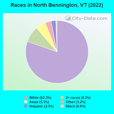
Races in North Bennington detailed stats: ancestries, foreign born residents, place of birth
According to our research of Vermont and other state lists, there were 3 registered sex offenders living in North Bennington, Vermont as of April 28, 2024.
The ratio of all residents to sex offenders in North Bennington is 561 to 1.
The ratio of registered sex offenders to all residents in this city is lower than the state average.
 Recent articles from our blog. Our writers, many of them Ph.D. graduates or candidates, create easy-to-read articles on a wide variety of topics.

 | North Bennington (2 replies) |
| Ranch style homes in Southern Vermont? (11 replies) |
| Question About old AMC / Dodge Dealership near Randolph - South Royalton?? (2 replies) |
| Possible Move From Upstate NY To VT (4 replies) |
| New passenger rail could link Albany and North Bennington (11 replies) |
| Taking job in Sunderland: relocation to Bennington area? (5 replies) |
Latest news from North Bennington, VT collected exclusively by city-data.com from local newspapers, TV, and radio stations
Ancestries: English (27.5%), Irish (10.9%), French Canadian (8.5%), European (5.1%), American (4.1%), French (3.2%).
Current Local Time: EST time zone
Incorporated in 1866
Elevation: 685 feet
Land area: 1.87 square miles.
Population density: 916 people per square mile (low).
127 residents are foreign born (4.1% Asia, 3.0% Europe).
| This village: | 8.9% |
| Vermont: | 4.4% |
Median real estate property taxes paid for housing units with mortgages in 2022: $6,130 (2.0%)
Median real estate property taxes paid for housing units with no mortgage in 2022: $4,582 (1.8%)
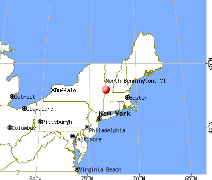
Nearest city with pop. 50,000+: Albany, NY  (33.0 miles , pop. 95,658).
Nearest city with pop. 200,000+: Boston, MA (117.1 miles , pop. 589,141).
Nearest city with pop. 1,000,000+: Bronx, NY (147.3 miles , pop. 1,332,650).
Nearest cities:
), ), ), Latitude: 42.92 N, Longitude: 73.24 W

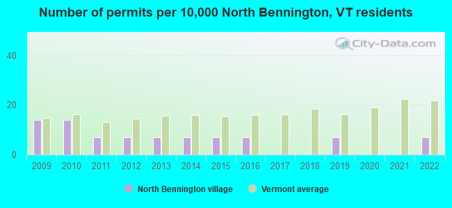
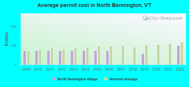
Single-family new house construction building permits:
- 2022: 1 building, cost: $257,000
- 2019: 1 building, cost: $150,000
- 2016: 1 building, cost: $187,500
- 2015: 1 building, cost: $187,500
- 2014: 1 building, cost: $187,500
- 2013: 1 building, cost: $187,500
- 2012: 1 building, cost: $187,500
- 2011: 1 building, cost: $187,500
- 2010: 2 buildings, average cost: $187,500
- 2009: 2 buildings, average cost: $187,500
| Here: | 2.7% |
| Vermont: | 2.0% |
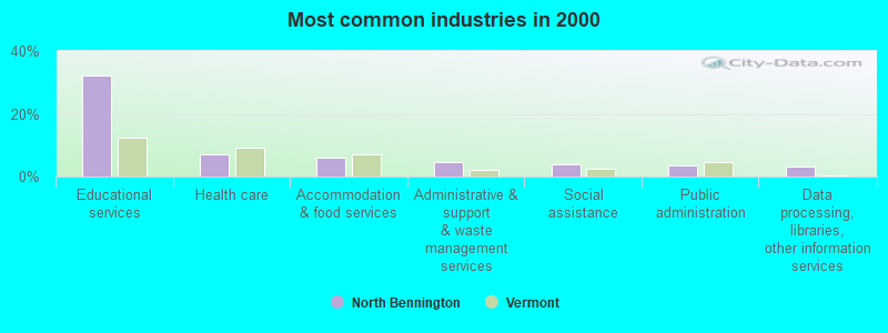
- Educational services (32.1%)
- Health care (7.0%)
- Accommodation & food services (6.2%)
- Administrative & support & waste management services (4.7%)
- Social assistance (3.8%)
- Public administration (3.5%)
- Data processing, libraries, other information services (3.0%)
- Educational services (29.1%)
- Public administration (6.6%)
- Administrative & support & waste management services (5.5%)
- Accommodation & food services (4.4%)
- Construction (4.2%)
- Arts, entertainment, recreation (3.6%)
- Professional, scientific, technical services (3.6%)
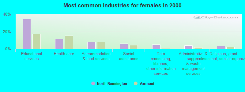
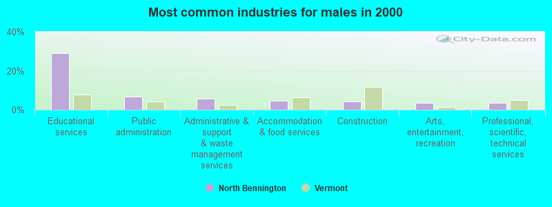
- Educational services (34.7%)
- Health care (11.4%)
- Accommodation & food services (7.7%)
- Social assistance (6.0%)
- Data processing, libraries, other information services (5.1%)
- Administrative & support & waste management services (4.0%)
- Religious, grantmaking, civic, professional, similar organizations (3.0%)
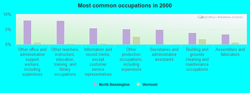
- Other office and administrative support workers, including supervisors (8.1%)
- Other teachers, instructors, education, training, and library occupations (8.0%)
- Information and record clerks, except customer service representatives (5.4%)
- Other production occupations, including supervisors (5.2%)
- Secretaries and administrative assistants (4.9%)
- Building and grounds cleaning and maintenance occupations (3.9%)
- Assemblers and fabricators (3.4%)
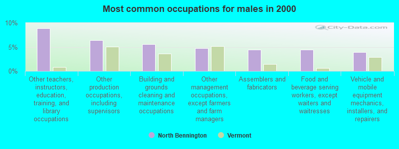
- Other teachers, instructors, education, training, and library occupations (8.9%)
- Other production occupations, including supervisors (6.4%)
- Building and grounds cleaning and maintenance occupations (5.5%)
- Other management occupations, except farmers and farm managers (4.7%)
- Assemblers and fabricators (4.4%)
- Food and beverage serving workers, except waiters and waitresses (4.4%)
- Vehicle and mobile equipment mechanics, installers, and repairers (3.9%)
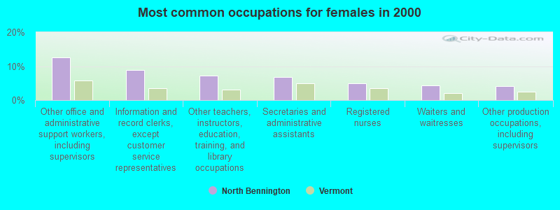
- Other office and administrative support workers, including supervisors (12.6%)
- Information and record clerks, except customer service representatives (8.8%)
- Other teachers, instructors, education, training, and library occupations (7.2%)
- Secretaries and administrative assistants (6.7%)
- Registered nurses (4.9%)
- Waiters and waitresses (4.4%)
- Other production occupations, including supervisors (4.2%)
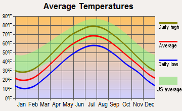
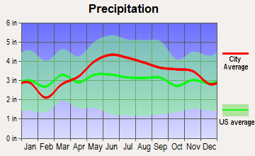
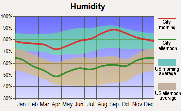
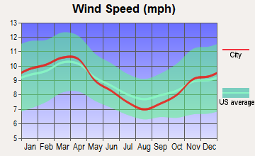
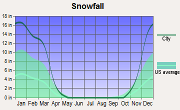
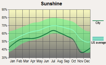
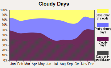
Average climate in North Bennington, Vermont
Based on data reported by over 4,000 weather stations
|
|

(lower is better)
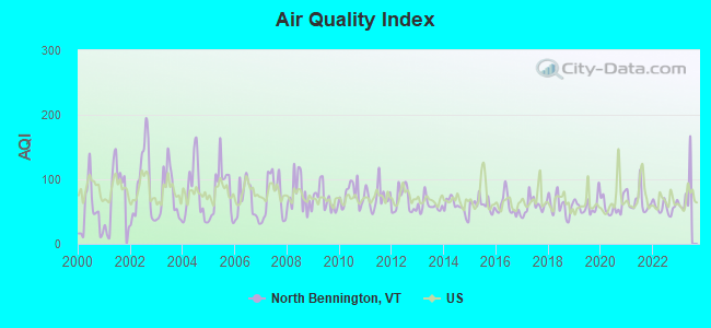
Air Quality Index (AQI) level in 2022 was 56.8. This is better than average.
| City: | 56.8 |
| U.S.: | 72.6 |
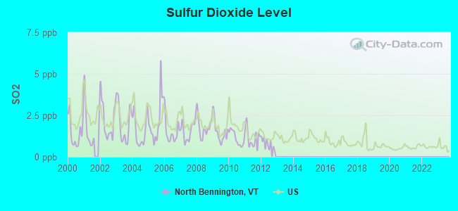
Sulfur Dioxide (SO2) [ppb] level in 2012 was 0.789. This is significantly better than average. Closest monitor was 9.2 miles away from the city center.
| City: | 0.789 |
| U.S.: | 1.515 |
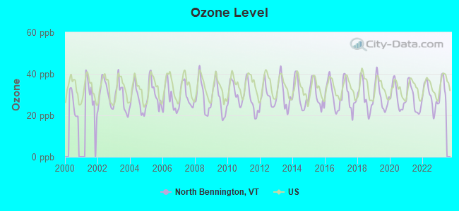
Ozone [ppb] level in 2022 was 29.1. This is about average. Closest monitor was 2.6 miles away from the city center.
| City: | 29.1 |
| U.S.: | 33.3 |
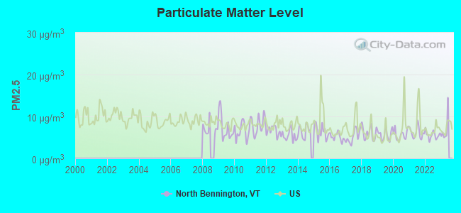
Particulate Matter (PM2.5) [µg/m3] level in 2022 was 5.56. This is significantly better than average. Closest monitor was 2.6 miles away from the city center.
| City: | 5.56 |
| U.S.: | 8.11 |
Tornado activity:
North Bennington-area historical tornado activity is significantly above Vermont state average. It is 40% smaller than the overall U.S. average.
On 5/31/1998, a category F3 (max. wind speeds 158-206 mph) tornado 3.1 miles away from the North Bennington village center injured 68 people and caused $71 million in damages.
On 8/28/1973, a category F4 (max. wind speeds 207-260 mph) tornado 36.0 miles away from the village center killed 4 people and injured 36 people and caused between $5,000,000 and $50,000,000 in damages.
Earthquake activity:
North Bennington-area historical earthquake activity is significantly above Vermont state average. It is 69% smaller than the overall U.S. average.On 10/7/1983 at 10:18:46, a magnitude 5.3 (5.1 MB, 5.3 LG, 5.1 ML, Class: Moderate, Intensity: VI - VII) earthquake occurred 90.2 miles away from the city center
On 4/20/2002 at 10:50:47, a magnitude 5.3 (5.3 ML, Depth: 3.0 mi) earthquake occurred 112.2 miles away from the city center
On 4/20/2002 at 10:50:47, a magnitude 5.2 (5.2 MB, 4.2 MS, 5.2 MW, 5.0 MW) earthquake occurred 110.7 miles away from North Bennington center
On 1/19/1982 at 00:14:42, a magnitude 4.7 (4.5 MB, 4.7 MD, 4.5 LG, Class: Light, Intensity: IV - V) earthquake occurred 91.8 miles away from North Bennington center
On 10/16/2012 at 23:12:25, a magnitude 4.7 (4.7 ML, Depth: 10.0 mi) earthquake occurred 138.2 miles away from North Bennington center
On 6/17/1991 at 08:53:16, a magnitude 4.1 (4.0 MB, 4.0 LG, Depth: 3.1 mi) earthquake occurred 75.8 miles away from North Bennington center
Magnitude types: regional Lg-wave magnitude (LG), body-wave magnitude (MB), duration magnitude (MD), local magnitude (ML), surface-wave magnitude (MS), moment magnitude (MW)
Natural disasters:
The number of natural disasters in Bennington County (15) is near the US average (15).Major Disasters (Presidential) Declared: 10
Emergencies Declared: 2
Causes of natural disasters: Floods: 8, Storms: 8, Tropical Storms: 2, Winter Storms: 2, Hurricane: 1, Landslide: 1, Snowstorm: 1, Wind: 1, Other: 1 (Note: some incidents may be assigned to more than one category).
Hospitals and medical centers in North Bennington:
Other hospitals and medical centers near North Bennington:
- VNA AND HOSPICE OF SVHC (Home Health Center, about 4 miles away; BENNINGTON, VT)
- VERMONT VETERANS HOME (Nursing Home, about 4 miles away; BENNINGTON, VT)
- CENTERS FOR LIVING AND REHAB (Nursing Home, about 4 miles away; BENNINGTON, VT)
- SOUTHWESTERN VERMONT MEDICAL CENTER Acute Care Hospitals (about 4 miles away; BENNINGTON, VT)
- BENNINGTON CONVEALESCENT CTR (Nursing Home, about 5 miles away; BENNINGTON, VT)
- BENNINGTON HEALTH AND REHAB (Nursing Home, about 5 miles away; BENNINGTON, VT)
- CRESCENT MANOR CARE CTRS (Nursing Home, about 5 miles away; BENNINGTON, VT)
Colleges/universities with over 2000 students nearest to North Bennington:
- Williams College (about 15 miles; Williamstown, MA; Full-time enrollment: 2,141)
- Rensselaer Polytechnic Institute (about 27 miles; Troy, NY; FT enrollment: 6,940)
- The Sage Colleges (about 27 miles; Troy, NY; FT enrollment: 2,499)
- Hudson Valley Community College (about 28 miles; Troy, NY; FT enrollment: 9,346)
- SUNY Empire State College (about 30 miles; Saratoga Springs, NY; FT enrollment: 9,473)
- Siena College (about 30 miles; Loudonville, NY; FT enrollment: 3,153)
- Skidmore College (about 30 miles; Saratoga Springs, NY; FT enrollment: 2,753)
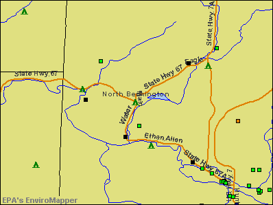
Points of interest:
Notable locations in North Bennington: Park McCullough House Museum (A), North Bennington Depot (B), John G McCullough Free Library (C), North Bennington Fire Department (D). Display/hide their locations on the map
Cemeteries: Rice-A Winslow Farm Cemetery (1), North Bennington Cemetery (2). Display/hide their locations on the map
Reservoir: Lake Paran (A). Display/hide its location on the map
Creek: Paran Creek (A). Display/hide its location on the map
Park in North Bennington: North Bennington Historic District (1). Display/hide its location on the map
Tourist attraction: Park McCullough House (Museums; Park & West).
| This village: | 2.2 people |
| Vermont: | 2.3 people |
| This village: | 56.7% |
| Whole state: | 62.5% |
| This village: | 6.9% |
| Whole state: | 9.2% |
Likely homosexual households (counted as self-reported same-sex unmarried-partner households)
- Lesbian couples: 0.6% of all households
- Gay men: 0.4% of all households
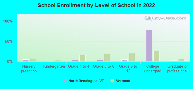
People in group quarters in North Bennington in 2010:
- 575 people in college/university student housing
- 24 people in nursing facilities/skilled-nursing facilities
- 11 people in emergency and transitional shelters (with sleeping facilities) for people experiencing homelessness
People in group quarters in North Bennington in 2000:
- 334 people in college dormitories (includes college quarters off campus)
- 33 people in nursing homes
- 11 people in other noninstitutional group quarters
Banks with branches in North Bennington (2011 data):
- Merchants Bank: Catamount Branch at 5 Bank Street, branch established on 1864/01/01. Info updated 2011/12/09: Bank assets: $1,615.1 mil, Deposits: $1,179.4 mil, headquarters in Burlington, VT, positive income, Commercial Lending Specialization, 34 total offices, Holding Company: Merchants Bancshares, Inc.
For population 15 years and over in North Bennington:

- Never married: 47.0%
- Now married: 27.8%
- Separated: 2.1%
- Widowed: 12.2%
- Divorced: 11.0%
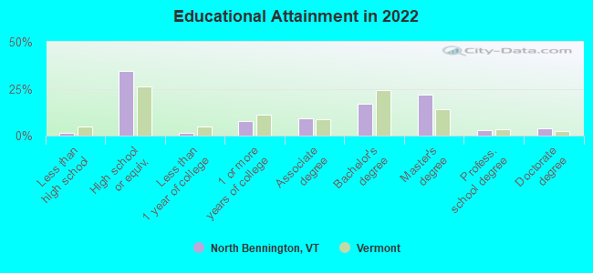
For population 25 years and over in North Bennington:
- High school or higher: 97.8%
- Bachelor's degree or higher: 43.0%
- Graduate or professional degree: 25.8%
- Unemployed: 4.6%
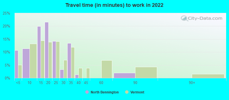
- Mean travel time to work (commute): 9.8 minutes
| Here: | 10.8 |
| Vermont average: | 10.8 |
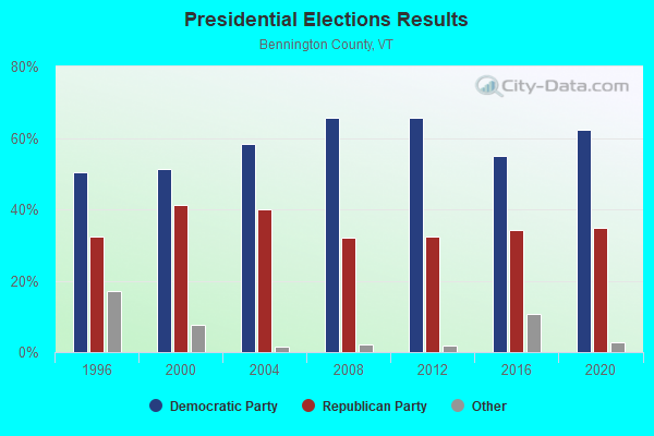
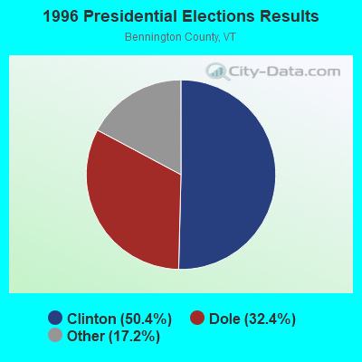
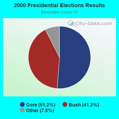
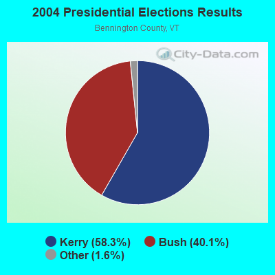
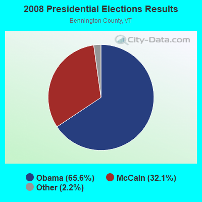
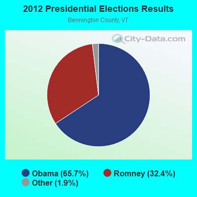
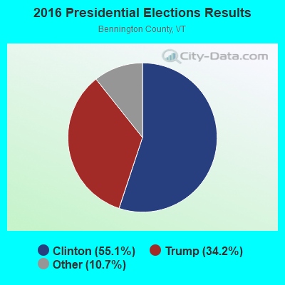
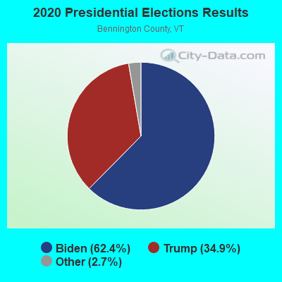
Graphs represent county-level data. Detailed 2008 Election Results
Political contributions by individuals in North Bennington, VT
Religion statistics for North Bennington, VT (based on Bennington County data)

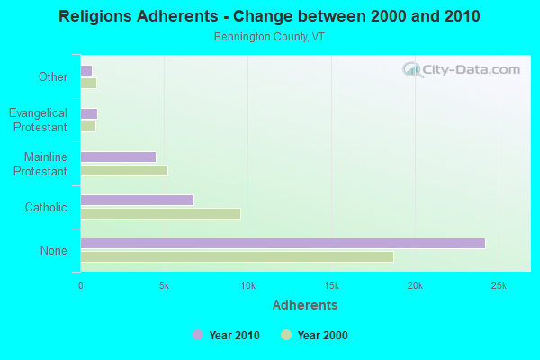
| Religion | Adherents | Congregations |
|---|---|---|
| Catholic | 6,742 | 8 |
| Mainline Protestant | 4,490 | 26 |
| Evangelical Protestant | 1,005 | 12 |
| Other | 693 | 5 |
| None | 24,195 | - |
Food Environment Statistics:
| This county: | 3.85 / 10,000 pop. |
| Vermont: | 3.84 / 10,000 pop. |
| This county: | 3.30 / 10,000 pop. |
| Vermont: | 1.95 / 10,000 pop. |
| This county: | 5.77 / 10,000 pop. |
| State: | 6.40 / 10,000 pop. |
| Here: | 16.48 / 10,000 pop. |
| State: | 11.52 / 10,000 pop. |
| Bennington County: | 8.4% |
| State: | 6.8% |
| Here: | 22.9% |
| Vermont: | 22.3% |
| Bennington County: | 11.6% |
| Vermont: | 13.3% |
Health and Nutrition:
| North Bennington: | 61.8% |
| Vermont: | 52.9% |
| This city: | 66.8% |
| Vermont: | 51.9% |
| North Bennington: | 26.9 |
| State: | 28.4 |
| North Bennington: | 12.1% |
| State: | 21.2% |
| This city: | 6.9 |
| Vermont: | 6.9 |
| This city: | 27.0% |
| Vermont: | 34.9% |
| North Bennington: | 70.9% |
| Vermont: | 59.7% |
| This city: | 81.7% |
| Vermont: | 79.6% |
More about Health and Nutrition of North Bennington, VT Residents
| Local government employment and payroll (March 2022) | |||||
| Function | Full-time employees | Monthly full-time payroll | Average yearly full-time wage | Part-time employees | Monthly part-time payroll |
|---|---|---|---|---|---|
| Water Supply | 3 | $11,514 | $46,056 | 0 | $0 |
| Streets and Highways | 2 | $8,374 | $50,244 | 0 | $0 |
| Other Government Administration | 0 | $0 | 7 | $1,680 | |
| Financial Administration | 0 | $0 | 2 | $731 | |
| Totals for Government | 5 | $19,889 | $47,734 | 9 | $2,411 |
North Bennington government finances - Expenditure in 2017 (per resident):
- Current Operations - Regular Highways: $286,000 ($166.96)
Local Fire Protection: $66,000 ($38.53)
General - Other: $51,000 ($29.77)
Parks and Recreation: $35,000 ($20.43)
Financial Administration: $35,000 ($20.43)
Libraries: $16,000 ($9.34)
- General - Interest on Debt: $17,000 ($9.92)
- Total Salaries and Wages: $109,000 ($63.63)
North Bennington government finances - Revenue in 2017 (per resident):
- Miscellaneous - Donations From Private Sources: $1,000 ($0.58)
- State Intergovernmental - Highways: $155,000 ($90.48)
- Tax - Property: $471,000 ($274.96)
North Bennington government finances - Debt in 2017 (per resident):
- Long Term Debt - Beginning Outstanding - Unspecified Public Purpose: $435,000 ($253.94)
Outstanding Unspecified Public Purpose: $385,000 ($224.75)
Retired Unspecified Public Purpose: $50,000 ($29.19)
North Bennington government finances - Cash and Securities in 2017 (per resident):
- Other Funds - Cash and Securities: $128,000 ($74.72)
Strongest AM radio stations in North Bennington:
- WBTN (1370 AM; 1 kW; BENNINGTON, VT; Owner: SOUTHERN VERMONT COLLEGE)
- WGY (810 AM; 50 kW; SCHENECTADY, NY; Owner: CLEAR CHANNEL BROADCASTING LICENSES, INC.)
- WPTR (1540 AM; 50 kW; ALBANY, NY; Owner: KIMTRON, INC.)
- WNNZ (640 AM; 50 kW; WESTFIELD, MA; Owner: CLEAR CHANNEL BROADCASTING LICENSES, INC.)
- WCRN (830 AM; 50 kW; WORCESTER, MA; Owner: CARTER BROADCASTING CORPORATION)
- WABY (1160 AM; 5 kW; MECHANICVILLE, NY; Owner: ANASTOS MEDIA GROUP, INC.)
- WTIC (1080 AM; 50 kW; HARTFORD, CT; Owner: INFINITY RADIO OPERATIONS INC.)
- WRKO (680 AM; 50 kW; BOSTON, MA; Owner: ENTERCOM BOSTON LICENSE, LLC)
- WROW (590 AM; 5 kW; ALBANY, NY; Owner: 6 JOHNSON ROAD LICENSES, INC.)
- WVNE (760 AM; daytime; 25 kW; LEICESTER, MA; Owner: BLOUNT MASSCOM, INC.)
- WOFX (980 AM; 5 kW; TROY, NY)
- WEEI (850 AM; 50 kW; BOSTON, MA; Owner: ENTERCOM BOSTON LICENSE, LLC)
- WIZZ (1520 AM; daytime; 10 kW; GREENFIELD, MA; Owner: P. & M. RADIO, LLC)
Strongest FM radio stations in North Bennington:
- WEQX (102.7 FM; MANCHESTER, VT; Owner: NORTHSHIRE COMMUNICATIONS, INC.)
- WJAN (95.1 FM; SUNDERLAND, VT; Owner: 6 JOHNSON ROAD LICENSES, INC.)
- WZEC (97.5 FM; HOOSICK FALLS, NY; Owner: GREAT NORTHERN RADIO, LLC)
- WVAY (100.7 FM; WILMINGTON, VT; Owner: GREAT NORTHERN RADIO, L.L.C.)
- WAMC-FM (90.3 FM; ALBANY, NY; Owner: WAMC)
- WBTN-FM (94.3 FM; BENNINGTON, VT; Owner: VERMONT PUBLIC RADIO)
- WNGN (91.9 FM; ARGYLE, NY; Owner: NORTHEAST GOSPEL BROADCASTING INC)
- WJJR (98.1 FM; RUTLAND, VT; Owner: 6 JOHNSON ROAD LICENSES, INC.)
- WZRT (97.1 FM; RUTLAND, VT; Owner: CAPSTAR TX LIMITED PARTNERSHIP)
- WEBK (105.3 FM; KILLINGTON, VT; Owner: 6 JOHNSON ROAD LICENSES, INC.)
- WGLV (91.7 FM; WOODSTOCK, VT; Owner: CHRISTIAN MINISTRIES INC)
- WHDQ-FM1 (106.1 FM; RUTLAND, VT; Owner: GREAT NORTHERN RADIO, L.L.C.)
- WVPR (89.5 FM; WINDSOR, VT; Owner: VERMONT PUBLIC RADIO)
- WMNB (100.1 FM; NORTH ADAMS, MA; Owner: BERKSHIRE BROADCASTING CO., INC.)
- WHDQ (106.1 FM; CLAREMONT, NH; Owner: GREAT NORTHERN RADIO, L.L.C.)
- WKBE (100.3 FM; WARRENSBURG, NY; Owner: 6 JOHNSON ROAD LICENSES, INC.)
- WRSY (101.5 FM; MARLBORO, VT; Owner: GREAT NORTHERN RADIO, L.L.C.)
- WCKM-FM (99.1 FM; LAKE GEORGE, NY; Owner: ENTERTRONICS, INC.)
- WNYQ (105.7 FM; QUEENSBURY, NY; Owner: VOX NEW YORK, L.L.C.)
- WLJH (90.9 FM; GLENS FALLS, NY; Owner: SOUND OF LIFE INC)
TV broadcast stations around North Bennington:
- WNGN-LP (Channel 26; TROY, NY; Owner: BRIAN A. LARSON)
- W53AS (Channel 53; POWNAL, ETC., VT; Owner: VERMONT ETV, INC.)
- WNYA-CA (Channel 39; EASTON, ETC., NY; Owner: VENTURE TECHNOLOGIES GROUP, LLC)
- WCDC-TV (Channel 19; ADAMS, MA; Owner: YOUNG BROADCASTING OF ALBANY, INC.)
North Bennington fatal accident list:
Jan 24, 1975 09:55 PM, Vehicles: 1, Persons: 4, Fatalities: 2
- National Bridge Inventory (NBI) Statistics
- 14Number of bridges
- 180ft / 54.6mTotal length
- $3,658,000Total costs
- 66,635Total average daily traffic
- 4,173Total average daily truck traffic
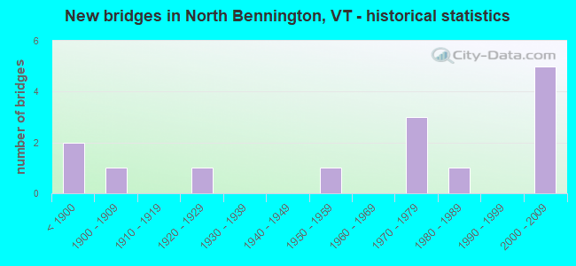
- New bridges - historical statistics
- 2Before 1900
- 11900-1909
- 11920-1929
- 11950-1959
- 31970-1979
- 11980-1989
- 52000-2009
FCC Registered Amateur Radio Licenses:
11 (See the full list of FCC Registered Amateur Radio Licenses in North Bennington)FAA Registered Aircraft:
2- Aircraft: TAYLORCRAFT AVIATION CORP. F21 (Category: Land, Seats: 2, Weight: Up to 12,499 Pounds), Engine: LYCOMING 0-235 SERIES (115 HP) (Reciprocating)
N-Number: 2004V, N2004V, N-2004V, Serial Number: F-1007, Year manufactured: 1980, Airworthiness Date: 09/25/1980, Certificate Issue Date: 11/06/2017
Registrant (Individual): David W Peacock, Po Box 371, North Bennington, VT 05257 - Aircraft: CHAMPION 7EC (Category: Land, Seats: 2, Weight: Up to 12,499 Pounds, Speed: 90 mph), Engine: CONT MOTOR C90 SERIES (95 HP) (Reciprocating)
N-Number: 7490B, N7490B, N-7490B, Serial Number: 7EC-552, Year manufactured: 1957, Airworthiness Date: 01/28/1957, Certificate Issue Date: 11/06/2017
Registrant (Individual): David W Peacock, Po Box 371, North Bennington, VT 05257
2002 - 2018 National Fire Incident Reporting System (NFIRS) incidents
- Fire incident types reported to NFIRS in North Bennington, VT
- 8987.3%Structure Fires
- 76.9%Outside Fires
- 32.9%Mobile Property/Vehicle Fires
- 32.9%Other
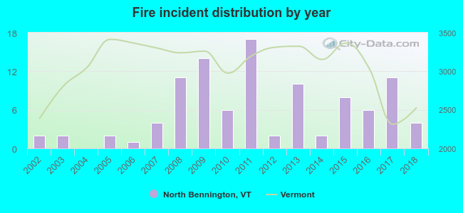 Based on the data from the years 2002 - 2018 the average number of fire incidents per year is 6. The highest number of fires - 17 took place in 2011, and the least - 0 in 2004. The data has a rising trend.
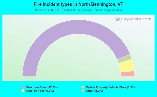 When looking into fire subcategories, the most reports belonged to: Structure Fires (87.3%), and Outside Fires (6.9%).
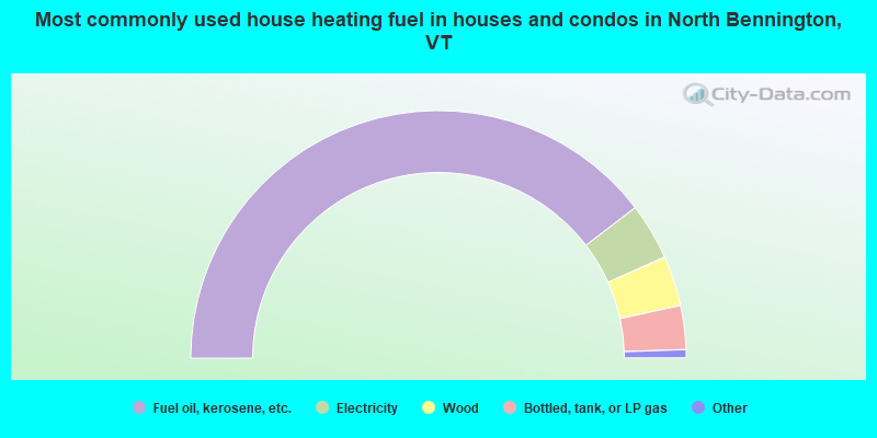
- 80.1%Fuel oil, kerosene, etc.
- 7.5%Electricity
- 6.6%Wood
- 5.8%Bottled, tank, or LP gas
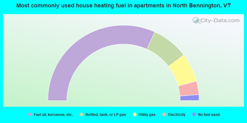
- 63.6%Fuel oil, kerosene, etc.
- 15.7%Bottled, tank, or LP gas
- 12.4%Utility gas
- 5.8%Electricity
- 2.5%No fuel used
North Bennington compared to Vermont state average:
- Unemployed percentage below state average.
- Median age significantly below state average.
- Foreign-born population percentage above state average.
- Length of stay since moving in significantly above state average.
- Number of college students significantly above state average.
North Bennington on our top lists:
- #38 on the list of "Top 101 cities with the most residents born in France (population 500+)"
- #81 on the list of "Top 101 counties with the lowest Particulate Matter (PM2.5) Annual air pollution readings in 2012 (µg/m3)"
- #92 on the list of "Top 101 counties with highest percentage of residents voting for Obama (Democrat) in the 2012 Presidential Election"

|
|
Total of 76 patent applications in 2008-2024.