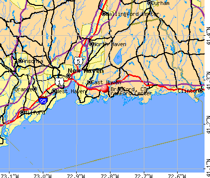
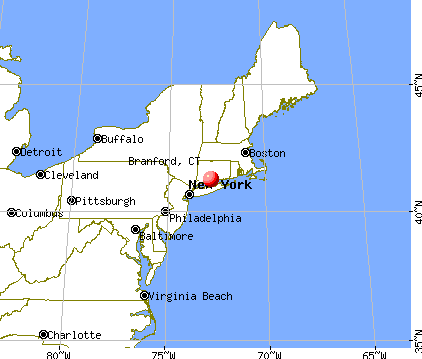
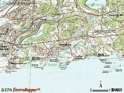
Branford, Connecticut
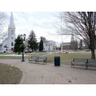
Branford: BRANFORD, CT TOWN GREEN

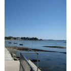
Branford: Branford Point
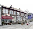
Branford: BRANFORD, CT - STONY CREEK SECTION OF TOWN
Branford: Cliff Walk Behind The Owenego Club

Branford: Branford shoreline From Limewood Ave.

Branford: Old Boat On Grass Off Linden Ave.

Branford: Branford Library

Branford: Branford Fireworks

Branford: Branford Beach

Branford: Branford Harbor Sunrise
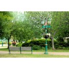
Branford: Branford Town Green
- add
your
Submit your own pictures of this town and show them to the world
- OSM Map
- General Map
- Google Map
- MSN Map
Population change since 2000: -2.3%
 |
| Males: 13,184 | |
| Females: 14,842 |
| Median resident age: | 47.0 years |
| Connecticut median age: | 39.2 years |
Zip codes: 06405.
| Branford: | $95,109 |
| CT: | $88,429 |
Estimated per capita income in 2022: $57,920 (it was $32,301 in 2000)
Branford town income, earnings, and wages data
Estimated median house or condo value in 2022: $369,684 (it was $171,000 in 2000)
| Branford: | $369,684 |
| CT: | $347,200 |
Mean prices in 2022: all housing units: $339,332; detached houses: $370,621; townhouses or other attached units: $220,634; in 2-unit structures: $230,566; in 3-to-4-unit structures: $204,968; in 5-or-more-unit structures: $169,619; mobile homes: $83,839
Detailed information about poverty and poor residents in Branford, CT


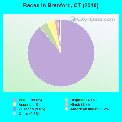
- 24,95589.0%White alone
- 1,1494.1%Hispanic
- 1,0203.6%Asian alone
- 5071.8%Black alone
- 2941.0%Two or more races
- 510.2%American Indian alone
- 480.2%Other race alone
- 20.01%Native Hawaiian and Other
Pacific Islander alone
Races in Branford detailed stats: ancestries, foreign born residents, place of birth
According to our research of Connecticut and other state lists, there were 21 registered sex offenders living in Branford, Connecticut as of April 26, 2024.
The ratio of all residents to sex offenders in Branford is 1,335 to 1.
The ratio of registered sex offenders to all residents in this city is lower than the state average.
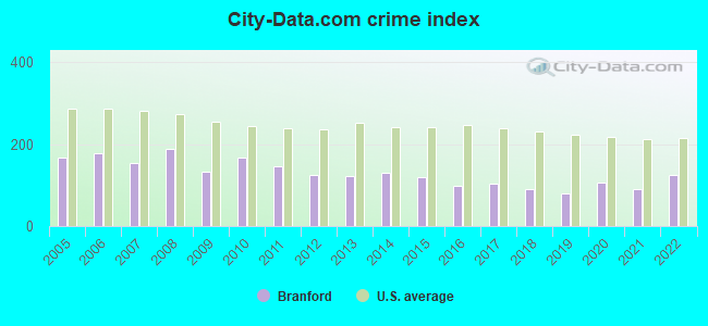
Type |
2009 |
2010 |
2011 |
2012 |
2013 |
2014 |
2015 |
2016 |
2017 |
2018 |
2019 |
2020 |
2021 |
2022 |
|---|---|---|---|---|---|---|---|---|---|---|---|---|---|---|
| Murders (per 100,000) | 1 (3.4) | 1 (3.6) | 0 (0.0) | 0 (0.0) | 1 (3.6) | 1 (3.6) | 0 (0.0) | 0 (0.0) | 0 (0.0) | 0 (0.0) | 0 (0.0) | 0 (0.0) | 0 (0.0) | 1 (3.6) |
| Rapes (per 100,000) | 0 (0.0) | 0 (0.0) | 0 (0.0) | 0 (0.0) | 0 (0.0) | 0 (0.0) | 0 (0.0) | 2 (7.1) | 0 (0.0) | 0 (0.0) | 3 (10.7) | 4 (14.3) | 3 (10.8) | 12 (42.6) |
| Robberies (per 100,000) | 9 (31.0) | 6 (21.4) | 11 (39.2) | 10 (35.6) | 3 (10.7) | 8 (28.6) | 5 (17.7) | 5 (17.8) | 7 (25.0) | 4 (14.2) | 5 (17.9) | 12 (43.0) | 7 (25.3) | 6 (21.3) |
| Assaults (per 100,000) | 14 (48.3) | 30 (107.0) | 15 (53.4) | 11 (39.2) | 13 (46.4) | 16 (57.2) | 12 (42.4) | 3 (10.7) | 9 (32.1) | 13 (46.2) | 3 (10.7) | 3 (10.8) | 9 (32.5) | 5 (17.8) |
| Burglaries (per 100,000) | 82 (282.8) | 101 (360.4) | 81 (288.5) | 56 (199.6) | 55 (196.3) | 55 (196.6) | 36 (127.3) | 32 (113.6) | 33 (117.7) | 24 (85.3) | 29 (103.6) | 34 (121.9) | 22 (79.4) | 18 (64.0) |
| Thefts (per 100,000) | 561 (1,935) | 656 (2,341) | 616 (2,194) | 597 (2,128) | 540 (1,927) | 586 (2,095) | 624 (2,207) | 482 (1,711) | 478 (1,705) | 403 (1,433) | 329 (1,175) | 354 (1,269) | 328 (1,184) | 426 (1,514) |
| Auto thefts (per 100,000) | 31 (106.9) | 50 (178.4) | 55 (195.9) | 25 (89.1) | 40 (142.8) | 23 (82.2) | 31 (109.6) | 29 (103.0) | 46 (164.1) | 51 (181.4) | 34 (121.4) | 68 (243.8) | 49 (176.9) | 36 (127.9) |
| Arson (per 100,000) | 1 (3.4) | 1 (3.6) | 1 (3.6) | 1 (3.6) | 1 (3.6) | 1 (3.6) | 0 (0.0) | 0 (0.0) | 0 (0.0) | 0 (0.0) | 0 (0.0) | 0 (0.0) | 0 (0.0) | 1 (3.6) |
| City-Data.com crime index | 131.6 | 168.1 | 146.1 | 124.8 | 121.9 | 131.3 | 119.8 | 97.8 | 103.5 | 91.3 | 80.0 | 105.4 | 89.8 | 126.4 |
The City-Data.com crime index weighs serious crimes and violent crimes more heavily. Higher means more crime, U.S. average is 246.1. It adjusts for the number of visitors and daily workers commuting into cities.
Crime rate in Branford detailed stats: murders, rapes, robberies, assaults, burglaries, thefts, arson
Full-time law enforcement employees in 2021, including police officers: 62 (51 officers - 42 male; 9 female).
| Officers per 1,000 residents here: | 1.84 |
| Connecticut average: | 2.10 |
 Recent articles from our blog. Our writers, many of them Ph.D. graduates or candidates, create easy-to-read articles on a wide variety of topics.

Latest news from Branford, CT collected exclusively by city-data.com from local newspapers, TV, and radio stations
Branford, CT City Guides:
Ancestries: Italian (30.2%), Irish (21.2%), English (12.4%), German (11.4%), Polish (7.5%), French (4.2%).
Current Local Time: EST time zone
Incorporated in 1685
Elevation: 49 feet
Land area: 22.0 square miles.
Population density: 1,275 people per square mile (low).
2,014 residents are foreign born (3.2% Europe, 2.3% Asia, 0.8% Latin America).
| This town: | 7.0% |
| Connecticut: | 10.9% |
| Branford town: | 1.7% ($2,912) |
| Connecticut: | 1.8% ($2,961) |
Nearest city with pop. 50,000+: New Haven, CT  (6.5 miles , pop. 123,626).
Nearest city with pop. 200,000+: North Hempstead, NY (56.7 miles , pop. 222,611).
Nearest city with pop. 1,000,000+: Bronx, NY (63.2 miles , pop. 1,332,650).
Nearest cities:
), ), Latitude: 41.28 N, Longitude: 72.81 W
Area code: 203

Branford, Connecticut accommodation & food services, waste management - Economy and Business Data
Single-family new house construction building permits:
- 2022: 32 buildings, average cost: $405,000
- 2021: 40 buildings, average cost: $347,400
- 2020: 25 buildings, average cost: $329,200
- 2019: 24 buildings, average cost: $285,600
- 2018: 21 buildings, average cost: $276,900
- 2017: 30 buildings, average cost: $242,500
- 2016: 27 buildings, average cost: $378,200
- 2015: 23 buildings, average cost: $336,100
- 2014: 29 buildings, average cost: $252,100
- 2013: 39 buildings, average cost: $280,800
- 2012: 30 buildings, average cost: $304,000
- 2011: 18 buildings, average cost: $282,200
- 2010: 24 buildings, average cost: $306,000
- 2009: 20 buildings, average cost: $254,700
- 2008: 27 buildings, average cost: $273,500
- 2007: 31 buildings, average cost: $255,900
- 2006: 33 buildings, average cost: $181,800
- 2005: 48 buildings, average cost: $334,500
- 2004: 46 buildings, average cost: $265,700
- 2003: 34 buildings, average cost: $307,800
- 2002: 58 buildings, average cost: $226,700
- 2001: 40 buildings, average cost: $227,300
- 2000: 26 buildings, average cost: $180,500
- 1999: 48 buildings, average cost: $139,000
- 1998: 39 buildings, average cost: $115,100
- 1997: 36 buildings, average cost: $115,800
| Here: | 3.1% |
| Connecticut: | 3.9% |
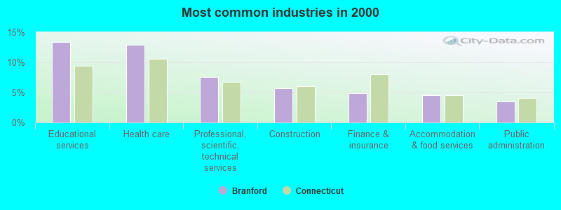
- Educational services (13.4%)
- Health care (12.9%)
- Professional, scientific, technical services (7.5%)
- Construction (5.7%)
- Finance & insurance (4.9%)
- Accommodation & food services (4.5%)
- Public administration (3.5%)
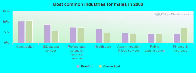
- Construction (10.3%)
- Educational services (8.7%)
- Professional, scientific, technical services (7.3%)
- Health care (6.5%)
- Accommodation & food services (4.6%)
- Public administration (4.3%)
- Finance & insurance (4.2%)
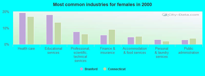
- Health care (19.4%)
- Educational services (18.1%)
- Professional, scientific, technical services (7.7%)
- Finance & insurance (5.7%)
- Accommodation & food services (4.4%)
- Personal & laundry services (3.0%)
- Public administration (2.7%)
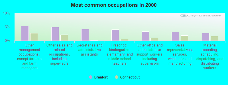
- Other management occupations, except farmers and farm managers (5.2%)
- Other sales and related occupations, including supervisors (4.9%)
- Secretaries and administrative assistants (4.2%)
- Preschool, kindergarten, elementary, and middle school teachers (4.1%)
- Other office and administrative support workers, including supervisors (3.3%)
- Sales representatives, services, wholesale and manufacturing (3.2%)
- Material recording, scheduling, dispatching, and distributing workers (2.8%)
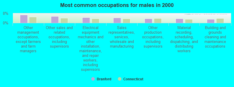
- Other management occupations, except farmers and farm managers (6.8%)
- Other sales and related occupations, including supervisors (5.7%)
- Electrical equipment mechanics and other installation, maintenance, and repair workers, including supervisors (4.7%)
- Sales representatives, services, wholesale and manufacturing (4.4%)
- Other production occupations, including supervisors (3.7%)
- Material recording, scheduling, dispatching, and distributing workers (3.6%)
- Building and grounds cleaning and maintenance occupations (3.1%)

- Secretaries and administrative assistants (8.1%)
- Preschool, kindergarten, elementary, and middle school teachers (6.7%)
- Other office and administrative support workers, including supervisors (5.1%)
- Registered nurses (4.8%)
- Other sales and related occupations, including supervisors (4.2%)
- Other management occupations, except farmers and farm managers (3.6%)
- Counselors, social workers, and other community and social service specialists (3.6%)
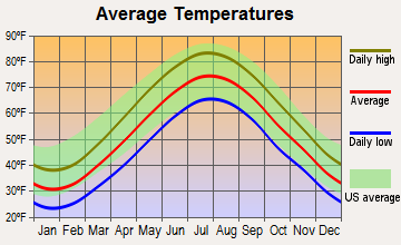
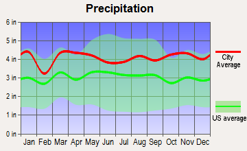
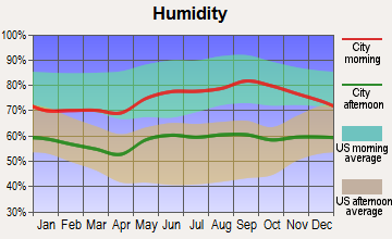
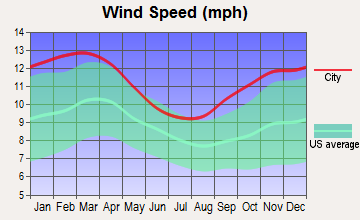
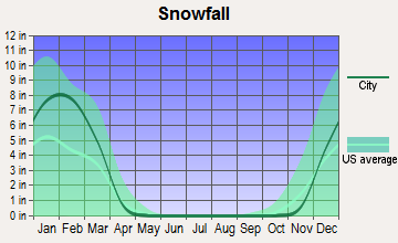
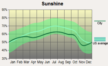
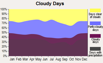
Average climate in Branford, Connecticut
Based on data reported by over 4,000 weather stations
(lower is better)
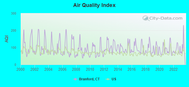
Air Quality Index (AQI) level in 2023 was 100. This is worse than average.
| City: | 100 |
| U.S.: | 73 |
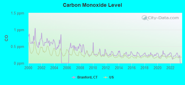
Carbon Monoxide (CO) [ppm] level in 2022 was 0.223. This is about average. Closest monitor was 5.3 miles away from the city center.
| City: | 0.223 |
| U.S.: | 0.251 |
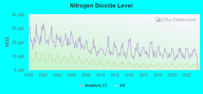
Nitrogen Dioxide (NO2) [ppb] level in 2022 was 11.6. This is significantly worse than average. Closest monitor was 5.3 miles away from the city center.
| City: | 11.6 |
| U.S.: | 5.1 |
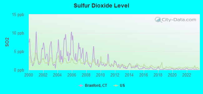
Sulfur Dioxide (SO2) [ppb] level in 2022 was 0.214. This is significantly better than average. Closest monitor was 4.4 miles away from the city center.
| City: | 0.214 |
| U.S.: | 1.515 |

Ozone [ppb] level in 2023 was 30.7. This is about average. Closest monitor was 5.3 miles away from the city center.
| City: | 30.7 |
| U.S.: | 33.3 |
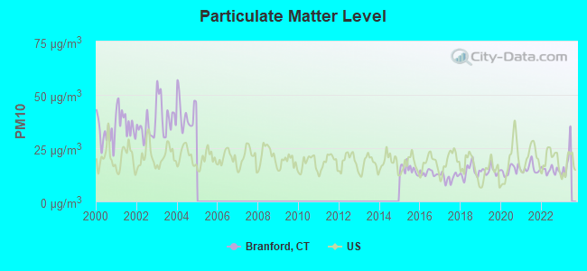
Particulate Matter (PM10) [µg/m3] level in 2022 was 14.6. This is better than average. Closest monitor was 5.1 miles away from the city center.
| City: | 14.6 |
| U.S.: | 19.2 |
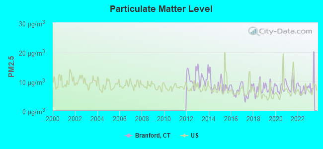
Particulate Matter (PM2.5) [µg/m3] level in 2022 was 7.52. This is about average. Closest monitor was 4.7 miles away from the city center.
| City: | 7.52 |
| U.S.: | 8.11 |
Tornado activity:
Branford-area historical tornado activity is slightly below Connecticut state average. It is 42% smaller than the overall U.S. average.
On 7/10/1989, a category F4 (max. wind speeds 207-260 mph) tornado 6.6 miles away from the Branford town center injured 40 people and caused between $50,000,000 and $500,000,000 in damages.
On 10/3/1979, a category F4 tornado 42.2 miles away from the town center killed 3 people and injured 500 people and caused between $50,000,000 and $500,000,000 in damages.
Earthquake activity:
Branford-area historical earthquake activity is significantly above Connecticut state average. It is 71% smaller than the overall U.S. average.On 10/7/1983 at 10:18:46, a magnitude 5.3 (5.1 MB, 5.3 LG, 5.1 ML, Class: Moderate, Intensity: VI - VII) earthquake occurred 200.9 miles away from the city center
On 4/20/2002 at 10:50:47, a magnitude 5.3 (5.3 ML, Depth: 3.0 mi) earthquake occurred 228.2 miles away from Branford center
On 4/20/2002 at 10:50:47, a magnitude 5.2 (5.2 MB, 4.2 MS, 5.2 MW, 5.0 MW) earthquake occurred 226.7 miles away from the city center
On 8/23/2011 at 17:51:04, a magnitude 5.8 (5.8 MW, Depth: 3.7 mi) earthquake occurred 359.1 miles away from the city center
On 1/19/1982 at 00:14:42, a magnitude 4.7 (4.5 MB, 4.7 MD, 4.5 LG, Class: Light, Intensity: IV - V) earthquake occurred 165.6 miles away from Branford center
On 8/22/1992 at 12:20:32, a magnitude 4.8 (4.8 MB, 3.8 MS, 4.7 LG, Depth: 6.2 mi) earthquake occurred 199.5 miles away from the city center
Magnitude types: regional Lg-wave magnitude (LG), body-wave magnitude (MB), duration magnitude (MD), local magnitude (ML), surface-wave magnitude (MS), moment magnitude (MW)
Natural disasters:
The number of natural disasters in New Haven County (26) is a lot greater than the US average (15).Major Disasters (Presidential) Declared: 15
Emergencies Declared: 11
Causes of natural disasters: Storms: 7, Hurricanes: 6, Floods: 5, Snowstorms: 5, Winter Storms: 4, Blizzards: 3, Snows: 3, Snowfall: 1, Tornado: 1, Tropical Storm: 1, Wind: 1 (Note: some incidents may be assigned to more than one category).
Main business address for: NEUROGEN CORP (PHARMACEUTICAL PREPARATIONS).
Hospitals and medical centers in Branford:
Amtrak stations near Branford:
- 7 miles: NEW HAVEN (50 UNION AVE.) . Services: ticket office, partially wheelchair accessible, enclosed waiting area, public restrooms, public payphones, snack bar, ATM, paid short-term parking, paid long-term parking, car rental agency, taxi stand, intercity bus service, public transit connection.
- 13 miles: WALLINGFORD (37 HALL AVE.) . Services: partially wheelchair accessible, enclosed waiting area, public payphones, free short-term parking, call for car rental service, call for taxi service.
- 19 miles: MERIDEN (60 STATE ST.) . Services: ticket office, partially wheelchair accessible, enclosed waiting area, public restrooms, public payphones, vending machines, call for car rental service, call for taxi service, public transit connection.
Colleges/Universities in Branford:
- Branford Hall Career Institute-Branford Campus (Full-time enrollment: 901; Location: 1 Summit Place; Private, for-profit; Website: www.branfordhall.edu)
- Porter and Chester Institute of Branford (Full-time enrollment: 326; Location: 221 W Main St; Private, for-profit; Website: www.porterchester.com)
- Branford Academy of Hair and Cosmetology (Full-time enrollment: 92; Location: 251 West Main St; Private, for-profit; Website: www.branfordacademy.com)
Colleges/universities with over 2000 students nearest to Branford:
- Gateway Community College (about 7 miles; New Haven, CT; Full-time enrollment: 4,672)
- Yale University (about 7 miles; New Haven, CT; FT enrollment: 13,121)
- University of New Haven (about 9 miles; West Haven, CT; FT enrollment: 6,205)
- Southern Connecticut State University (about 9 miles; New Haven, CT; FT enrollment: 8,708)
- Quinnipiac University (about 11 miles; Hamden, CT; FT enrollment: 8,153)
- Porter and Chester Institute of Stratford (about 20 miles; Stratford, CT; FT enrollment: 2,822)
- Wesleyan University (about 21 miles; Middletown, CT; FT enrollment: 3,517)
Public high schools in Branford:
- BRANFORD HIGH SCHOOL (Students: 944, Location: 185 EAST MAIN STREET, Grades: 9-12)
- BRANFORD HIGH SCHOOL HORIZONS PROGRAM (Location: 185 EAST MAIN STREET, Grades: 10-12)
Public elementary/middle schools in Branford:
- FRANCIS WALSH INTERMEDIATE SCHOOL (Students: 1,118, Location: 185 DAMASCUS ROAD, Grades: 5-8)
- MARY R. TISKO SCHOOL (Students: 543, Location: 118 DAMASCUS ROAD, Grades: PK-4)
- MARY T. MURPHY SCHOOL (Students: 485, Location: 14 BRUSHY PLAIN ROAD, Grades: PK-4)
- JOHN B. SLINEY SCHOOL (Students: 431, Location: 23 EADES STREET, Grades: PK-4)
Private elementary/middle school in Branford:
Points of interest:
Notable locations in Branford: Twin Lakes Golf Course (A), Connecticut State Boat Launching Area (B), James Blackstone Memorial Library (C), Connecticut Trolley Museum (D), Community House (E), Branford Counseling Center (F), Willoughby Wallace Memorial Library (G), Branford Fire Department Stony Creek Company 5 (H), Branford Fire Department Indian Neck Company 9 (I), Branford Fire Department M P Rice Company 2 (J), Branford Fire Department - Short Beach Company 4 (K), Branford Fire Department Headquarters (L). Display/hide their locations on the map
Shopping Centers: Branford Craft Village Shopping Center (1), Branford Hills Plaza Shopping Center (2), Branford Square Shopping Center (3), Branhaven Shopping Center (4), Brushy Hill Shopping Center (5), Cherry Hill Shopping Center (6), Orchard Hill Plaza Shopping Center (7), Market Place Shopping Center (8), Lockworks Shopping Center (9). Display/hide their locations on the map
Main business address in Branford: NEUROGEN CORP (A). Display/hide its location on the map
Churches in Branford include: New Life Apostolic Church (A), Saint Elizabeths Church (B), Saint Marys Church of Branford (C), Saint Stephens African Methodist Episcopal Zion Church (D), Saint Thereses Church (E), Tabor Lutheran Church (F), Trinity Episcopal Church (G), United Methodist Church (H), Church of Christ (I). Display/hide their locations on the map
Cemeteries: Branford Center Cemetery (1), Center Cemetery (2), Saint Agnes Cemetery (3), Damascus Cemetery (4), Tabor Cemetery (5), Mill Plain Cemetery (6). Display/hide their locations on the map
Lakes and reservoirs: Talmage Pond (A), Talmages Ice Pond (B), Youngs Pond (C), Griffins Pond (D), Lidyhites Pond (E), Branford Supply Ponds (F), Wards Millpond (G). Display/hide their locations on the map
Streams, rivers, and creeks: Notch Hill Brook (A), Pisgah Brook (B), Beaver Swamp Brook (C), Hoadley Creek (D). Display/hide their locations on the map
Parks in Branford include: Youngs Pond Park (1), Veterans Memorial Park (2), Supply Pond Park (3), Stony Creek-Thimble Island Historic District (4), Pawson Park Marsh Wildlife Area (5), Parker Memorial Park (6), Branford Center Historic District (7), Branford Point Historic District (8), East Haven Marsh Wildlife Area (9). Display/hide their locations on the map
Beaches: Hotchkiss Grove Beach (A), Short Beach (B), Hotchkiss Cove Beach (C). Display/hide their locations on the map
Tourist attractions: Branford Historical Society-Harrison House (Historical Places & Services; 124 Main Street) (1), Carr Travel (Ski & Helicopter Tours; 1018 Main Street Suite 1) (2), Branford Town - Senior Citizens Center- Administrative Departments- Public Libra (Cultural Attractions- Events- & Facilities; 11 Cherry Hill Road) (3), Thimble Islands Cruises Aboard Sea Mist (Tours & Charters; Stony Creek Dock) (4), T & A Tours (Tours & Charters; 21 Forest Street) (5). Display/hide their approximate locations on the map
Hotels: Best Value Inn (565 East Main Street) (1), Economy Inn (309 East Main Street) (2), Branford Motel (470 East Main Street) (3), Days Inn & Conference Center (375 East Main Street) (4), Motel 6 (320 East Main Street) (5), Ramada Limited (3 Business Park Drive) (6), Advanced Motel (81 Leetes Island Road) (7). Display/hide their approximate locations on the map
Court: Branford Town - Probate Court (1019 Main Street) (1). Display/hide its approximate location on the map
Birthplace of: Alvin T. Smith - Judge, John Baldwin (educator) - Educator and philanthropist, Timothy Blackstone - Railroad executive, Aaron S. Lanfare - Civil War Medal of Honor recipient, Ellsworth Foote - Politician, Joseph Barker (Massachusetts) - Politician, Ollie Sax - Baseball player.
Drinking water stations with addresses in Branford and their reported violations in the past:
QUONNIPAUG HILLS - SECTION I (Population served: 27, Groundwater):Past health violations:Past monitoring violations:
- MCL, Monthly (TCR) - In OCT-2011, Contaminant: Coliform. Follow-up actions: St Public Notif requested (NOV-21-2011), St Violation/Reminder Notice (NOV-21-2011), St Compliance achieved (NOV-30-2011), St Public Notif received (DEC-06-2012)
- MCL, Monthly (TCR) - In SEP-2011, Contaminant: Coliform. Follow-up actions: St Public Notif requested (OCT-18-2011), St Violation/Reminder Notice (OCT-18-2011), St Public Notif received (OCT-20-2011), St Compliance achieved (NOV-30-2011)
- MCL, Monthly (TCR) - In JUN-2011, Contaminant: Coliform. Follow-up actions: St Public Notif requested (JUN-13-2011), St Violation/Reminder Notice (JUN-13-2011), St Public Notif received (JUL-12-2011), St Compliance achieved (JUL-31-2011)
- MCL, Monthly (TCR) - Between JUL-2010 and SEP-2010, Contaminant: Coliform. Follow-up actions: St Public Notif requested (OCT-18-2010), St Violation/Reminder Notice (OCT-18-2010), St Public Notif received (OCT-21-2010), St Compliance achieved (OCT-31-2010)
- Monitoring, Repeat Major (TCR) - In AUG-2011, Contaminant: Coliform (TCR). Follow-up actions: St Compliance achieved (SEP-30-2011), St Admin Penalty assessed (DEC-19-2011), St Formal NOV issued (DEC-19-2011), St Public Notif requested (DEC-19-2011), St Public Notif received (JAN-19-2012)
- 2 routine major monitoring violations
- 49 regular monitoring violations
| This town: | 2.2 people |
| Connecticut: | 2.5 people |
| This town: | 58.2% |
| Whole state: | 66.3% |
| This town: | 6.5% |
| Whole state: | 6.6% |
Likely homosexual households (counted as self-reported same-sex unmarried-partner households)
- Lesbian couples: 0.5% of all households
- Gay men: 0.3% of all households
| This town: | 4.1% |
| Whole state: | 7.9% |
| This town: | 1.5% |
| Whole state: | 3.9% |
People in group quarters in Branford in 2010:
- 176 people in nursing facilities/skilled-nursing facilities
- 48 people in other noninstitutional facilities
- 31 people in group homes intended for adults
People in group quarters in Branford in 2000:
- 192 people in nursing homes
- 49 people in hospitals/wards and hospices for chronically ill
- 49 people in hospices or homes for chronically ill
- 22 people in other group homes
- 12 people in other noninstitutional group quarters
- 8 people in homes for the mentally ill
Banks with most branches in Branford (2011 data):
- People's United Bank: Branford Branch at 500 East Main Street, branch established on 1990/11/01; Leetes Island Stop And Shop Branch at 22 Leetes Island Road, branch established on 2002/02/18. Info updated 2012/02/16: Bank assets: $27,319.3 mil, Deposits: $20,835.4 mil, headquarters in Bridgeport, CT, positive income, Commercial Lending Specialization, 374 total offices
- First Niagara Bank, National Association: Branford Green Branch at 1026 Main Street, branch established on 1988/12/10; Branford East Branch at 367 East Main Street, branch established on 2000/12/15. Info updated 2011/06/09: Bank assets: $32,750.6 mil, Deposits: $19,595.4 mil, headquarters in Buffalo, NY, positive income, Commercial Lending Specialization, 351 total offices, Holding Company: First Niagara Financial Group, Inc.
- RBS Citizens, National Association: Branford Branch at 119 Montowese Street, branch established on 1996/10/21; Branford East Branch at 568 East Main Street, branch established on 1989/09/29. Info updated 2007/09/19: Bank assets: $106,940.6 mil, Deposits: $75,690.2 mil, headquarters in Providence, RI, positive income, 1135 total offices, Holding Company: Uk Financial Investments Limited
- Capital One, National Association: Branford Main at 45 South Main Street, branch established on 1889/01/01. Info updated 2011/07/01: Bank assets: $133,477.8 mil, Deposits: $97,063.7 mil, headquarters in Mclean, VA, positive income, 984 total offices, Holding Company: Capital One Financial Corporation
- Webster Bank, National Association: Branford Branch at 1 South Main Street, branch established on 1988/01/22. Info updated 2008/12/23: Bank assets: $18,674.3 mil, Deposits: $13,861.5 mil, headquarters in Waterbury, CT, positive income, Commercial Lending Specialization, 167 total offices, Holding Company: Webster Financial Corporation
- TD Bank, National Association: Branford Branch at 1003 West Main Street, branch established on 2009/04/01. Info updated 2010/10/04: Bank assets: $188,912.6 mil, Deposits: $153,149.8 mil, headquarters in Wilmington, DE, positive income, 1314 total offices, Holding Company: Toronto-Dominion Bank, The
- Sovereign Bank, National Association: The Branford Branch at 471 East Main Street, branch established on 1971/07/26. Info updated 2012/01/31: Bank assets: $78,146.9 mil, Deposits: $48,042.9 mil, headquarters in Wilmington, DE, positive income, Commercial Lending Specialization, 718 total offices, Holding Company: Banco Santander, S.A.
- The Bank of Southern Connecticut: Branford Branch at 445 West Main Street, branch established on 2002/10/07. Info updated 2006/11/03: Bank assets: $145.3 mil, Deposits: $132.8 mil, headquarters in New Haven, CT, negative income in the last year, Commercial Lending Specialization, 4 total offices, Holding Company: Southern Connecticut Bancorp, Inc
- Bank of America, National Association: Branford Branch at 1081 West Main Street, branch established on 1972/03/13. Info updated 2009/11/18: Bank assets: $1,451,969.3 mil, Deposits: $1,077,176.8 mil, headquarters in Charlotte, NC, positive income, 5782 total offices, Holding Company: Bank Of America Corporation
- 2 other banks with 2 local branches
For population 15 years and over in Branford:
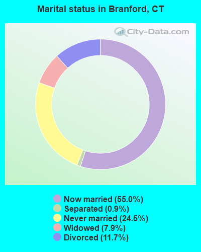
- Never married: 24.5%
- Now married: 55.0%
- Separated: 0.9%
- Widowed: 7.9%
- Divorced: 11.7%
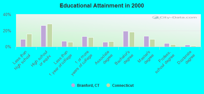
For population 25 years and over in Branford:
- High school or higher: 90.6%
- Bachelor's degree or higher: 38.7%
- Graduate or professional degree: 19.4%
- Unemployed: 3.2%
- Mean travel time to work (commute): 25.2 minutes
| Here: | 11.5 |
| Connecticut average: | 12.8 |
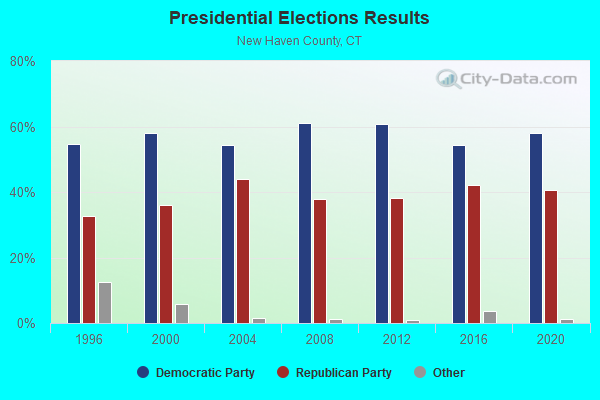
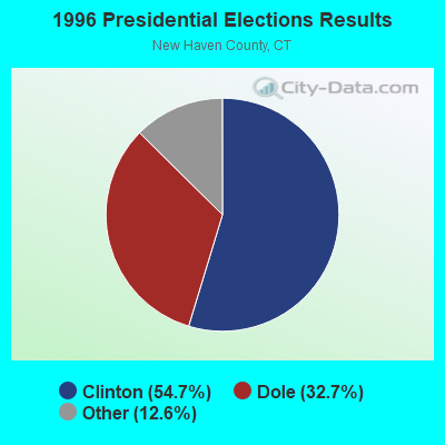
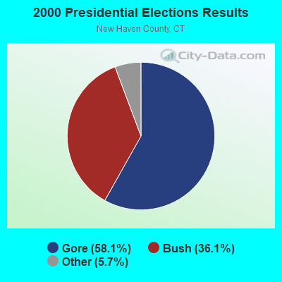
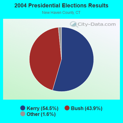
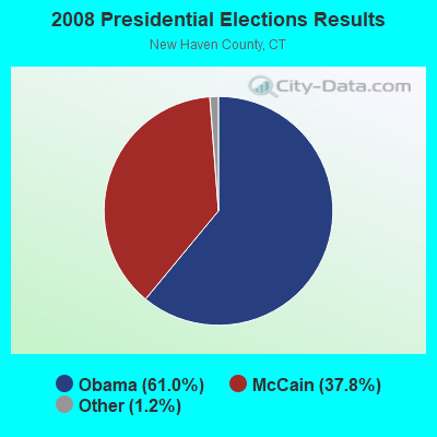
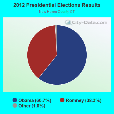
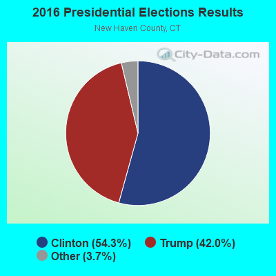
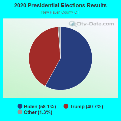
Graphs represent county-level data. Detailed 2008 Election Results
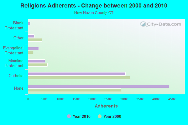
Religion statistics for Branford, CT (based on New Haven County data)
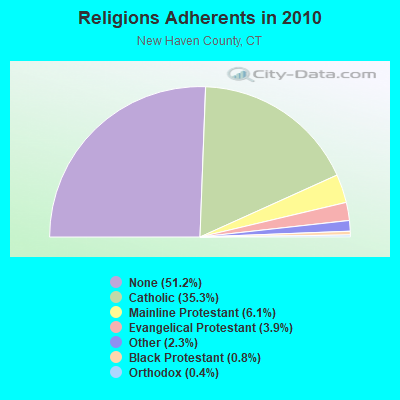
| Religion | Adherents | Congregations |
|---|---|---|
| Catholic | 304,677 | 104 |
| Mainline Protestant | 52,851 | 149 |
| Evangelical Protestant | 33,484 | 208 |
| Other | 19,943 | 79 |
| Black Protestant | 6,471 | 35 |
| Orthodox | 3,731 | 11 |
| None | 441,320 | - |
Food Environment Statistics:
| New Haven County: | 2.04 / 10,000 pop. |
| Connecticut: | 2.21 / 10,000 pop. |
| This county: | 0.08 / 10,000 pop. |
| State: | 0.07 / 10,000 pop. |
| New Haven County: | 1.14 / 10,000 pop. |
| Connecticut: | 1.02 / 10,000 pop. |
| New Haven County: | 2.20 / 10,000 pop. |
| State: | 2.27 / 10,000 pop. |
| Here: | 9.05 / 10,000 pop. |
| State: | 9.19 / 10,000 pop. |
| This county: | 8.2% |
| Connecticut: | 7.3% |
| New Haven County: | 24.0% |
| Connecticut: | 21.5% |
| This county: | 15.4% |
| State: | 15.8% |
5.40% of this county's 2021 resident taxpayers lived in other counties in 2020 ($78,288 average adjusted gross income)
| Here: | 5.40% |
| Connecticut average: | 5.79% |
0.02% of residents moved from foreign countries ($112 average AGI)
New Haven County: 0.02% Connecticut average: 0.02%
Top counties from which taxpayers relocated into this county between 2020 and 2021:
| from Fairfield County, CT | |
| from Hartford County, CT | |
| from Middlesex County, CT |
5.51% of this county's 2020 resident taxpayers moved to other counties in 2021 ($77,261 average adjusted gross income)
| Here: | 5.51% |
| Connecticut average: | 5.82% |
0.01% of residents moved to foreign countries ($54 average AGI)
New Haven County: 0.01% Connecticut average: 0.02%
Top counties to which taxpayers relocated from this county between 2020 and 2021:
| to Hartford County, CT | |
| to Fairfield County, CT | |
| to Middlesex County, CT |
| Businesses in Branford, CT | ||||
| Name | Count | Name | Count | |
|---|---|---|---|---|
| AT&T | 1 | Kohl's | 1 | |
| Ace Hardware | 1 | MasterBrand Cabinets | 1 | |
| Advance Auto Parts | 1 | McDonald's | 3 | |
| Baymont Inn | 1 | Motel 6 | 1 | |
| Ben & Jerry's | 1 | New Balance | 1 | |
| Blockbuster | 1 | Nike | 3 | |
| Burger King | 1 | Payless | 1 | |
| CVS | 1 | Pier 1 Imports | 1 | |
| Curves | 1 | Popeyes | 1 | |
| DHL | 1 | RadioShack | 1 | |
| Days Inn | 1 | Rodeway Inn | 1 | |
| DressBarn | 1 | Sprint Nextel | 1 | |
| Dressbarn | 1 | Staples | 1 | |
| Dunkin Donuts | 5 | Starbucks | 2 | |
| FedEx | 6 | Stop & Shop | 1 | |
| Firestone Complete Auto Care | 1 | Subaru | 1 | |
| Ford | 1 | Subway | 4 | |
| GNC | 1 | T-Mobile | 2 | |
| GameStop | 1 | Taco Bell | 1 | |
| Gap | 1 | U-Haul | 1 | |
| H&R Block | 1 | UPS | 8 | |
| Holiday Inn | 1 | Walgreens | 2 | |
| Jones New York | 3 | Walmart | 1 | |
| Justice | 1 | Wendy's | 1 | |
| KFC | 1 | YMCA | 1 | |
Strongest AM radio stations in Branford:
- WELI (960 AM; 5 kW; NEW HAVEN, CT; Owner: CLEAR CHANNEL BROADCASTING LICENSES, INC.)
- WTIC (1080 AM; 50 kW; HARTFORD, CT; Owner: INFINITY RADIO OPERATIONS INC.)
- WFAN (660 AM; 50 kW; NEW YORK, NY; Owner: INFINITY BROADCASTING OPERATIONS, INC.)
- WNNZ (640 AM; 50 kW; WESTFIELD, MA; Owner: CLEAR CHANNEL BROADCASTING LICENSES, INC.)
- WGSM (740 AM; 25 kW; HUNTINGTON, NY; Owner: K RADIO LICENSEE, INC.)
- WCBS (880 AM; 50 kW; NEW YORK, NY; Owner: INFINITY BROADCASTING OPERATIONS, INC.)
- WADS (690 AM; daytime; 3 kW; ANSONIA, CT; Owner: RADIO AMOR, INC.)
- WAVZ (1300 AM; 1 kW; NEW HAVEN, CT; Owner: CLEAR CHANNEL BROADCASTING LICENSES, INC.)
- WMCA (570 AM; 50 kW; NEW YORK, NY; Owner: SALEM MEDIA OF NEW YORK, LLC)
- WYBC (1340 AM; 1 kW; NEW HAVEN, CT; Owner: YALE BROADCASTING COMPANY, INC.)
- WFIF (1500 AM; daytime; 5 kW; MILFORD, CT)
- WABC (770 AM; 50 kW; NEW YORK, NY; Owner: WABC-AM RADIO, INC.)
- WOR (710 AM; 50 kW; NEW YORK, NY; Owner: BUCKLEY BROADCASTING CORPORATION)
Strongest FM radio stations in Branford:
- WKCI-FM (101.3 FM; HAMDEN, CT; Owner: CLEAR CHANNEL BROADCASTING LICENSES, INC.)
- WPLR (99.1 FM; NEW HAVEN, CT; Owner: COX RADIO, INC.)
- W227AJ (93.3 FM; NORTHFORD, CT; Owner: SACRED HEART UNIVERSITY)
- WYBC-FM (94.3 FM; NEW HAVEN, CT; Owner: YALE BROADCASTING CO., INC.)
- WKSS (95.7 FM; HARTFORD-MERIDEN, CT; Owner: CAPSTAR TX LIMITED PARTNERSHIP)
- WWYZ (92.5 FM; WATERBURY, CT; Owner: CAPSTAR TX LIMITED PARTNERSHIP)
- WZMX (93.7 FM; HARTFORD, CT; Owner: INFINITY RADIO OPERATIONS INC.)
- WHCN (105.9 FM; HARTFORD, CT; Owner: CAPSTAR TX LIMITED PARTNERSHIP)
- WMRQ (104.1 FM; WATERBURY, CT; Owner: CAPSTAR TX LIMITED PARTNERSHIP)
- WPKT (90.5 FM; MERIDEN, CT; Owner: CONNECTICUT PUBLIC BROADCASTING, INC)
- WDRC-FM (102.9 FM; HARTFORD, CT; Owner: BUCKLEY BROADCASTING CORPORATION)
- WRCH (100.5 FM; NEW BRITAIN, CT; Owner: INFINITY RADIO OPERATIONS INC.)
- WEZN-FM (99.9 FM; BRIDGEPORT, CT; Owner: CXR HOLDINGS, INC.)
- WSHU-FM (91.1 FM; FAIRFIELD, CT; Owner: SACRED HEART UNIVERSITY, INC.)
- WGRS (91.5 FM; GUILFORD, CT; Owner: MONROE BOARD OF EDUCATION)
- WRXC (90.1 FM; SHELTON, CT; Owner: MONROE BOARD OF EDUCATION)
- WPKN (89.5 FM; BRIDGEPORT, CT; Owner: WPKN, INC.)
- WALK-FM (97.5 FM; PATCHOGUE, NY; Owner: AMFM RADIO LICENSES, L.L.C.)
- WNHU (88.7 FM; WEST HAVEN, CT; Owner: UNIVERSITY OF NEW HAVEN)
- W252AS (98.3 FM; NEW HAVEN, CT; Owner: MONROE BOARD OF EDUCATION)
TV broadcast stations around Branford:
- WTNH (Channel 8; NEW HAVEN, CT; Owner: WTNH BROADCASTING, INC.)
- WEDY (Channel 65; NEW HAVEN, CT; Owner: CONNECTICUT PUBLIC BROADCASTING, INC.)
- WCTX (Channel 59; NEW HAVEN, CT; Owner: WTNH BROADCASTING, INC.)
- WTIC-TV (Channel 61; HARTFORD, CT; Owner: TRIBUNE TELEVISION COMPANY)
- W11BJ (Channel 11; HARTFORD, CT; Owner: COMMUNICATIONS SITE MANAGEMENT LLC)
- WTXX (Channel 20; WATERBURY, CT; Owner: WTXX INC.)
- WVIT (Channel 30; NEW BRITAIN, CT; Owner: OUTLET BROADCASTING, INC)
- W51BZ (Channel 51; NEW HAVEN, CT; Owner: it COMMUNICATIONS, INC.)
- WEDH (Channel 24; HARTFORD, CT; Owner: CONNECTICUT PUBLIC BROADCASTING, INC.)
- WHPX (Channel 26; NEW LONDON, CT; Owner: PAXSON HARTFORD LICENSE, INC.)
- W28AJ (Channel 28; ALLINGTOWN, CT; Owner: PAGING ASSOCIATES, INC.)
- WUVN (Channel 18; HARTFORD, CT; Owner: ENTRAVISION HOLDINGS, LLC)
- WEDW (Channel 49; BRIDGEPORT, CT; Owner: CONNECTICUT PUBLIC BROADCASTING, INC.)
- WFTY (Channel 67; SMITHTOWN, NY; Owner: UNIVISION NEW YORK LLC)
- WLNY (Channel 55; RIVERHEAD, NY; Owner: WLNY-TV, INC.)
- WSAH (Channel 43; BRIDGEPORT, CT; Owner: WSAH LICENSE, INC.)
Medal of Honor Recipients
Medal of Honor Recipient born in Branford: Aaron S. Lanfare.
- National Bridge Inventory (NBI) Statistics
- 45Number of bridges
- 295ft / 89.8mTotal length
- $10,910,000Total costs
- 1,511,893Total average daily traffic
- 158,879Total average daily truck traffic
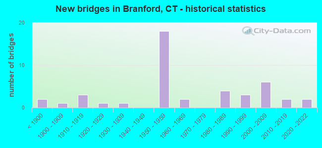
- New bridges - historical statistics
- 2Before 1900
- 11900-1909
- 31910-1919
- 11920-1929
- 11930-1939
- 181950-1959
- 21960-1969
- 41980-1989
- 31990-1999
- 62000-2009
- 22010-2019
- 22020-2022
FCC Registered Cell Phone Towers:
1 (See the full list of FCC Registered Cell Phone Towers in Branford)FCC Registered Antenna Towers:
77 (See the full list of FCC Registered Antenna Towers)FCC Registered Private Land Mobile Towers:
2 (See the full list of FCC Registered Private Land Mobile Towers in Branford, CT)FCC Registered Broadcast Land Mobile Towers:
12 (See the full list of FCC Registered Broadcast Land Mobile Towers)FCC Registered Microwave Towers:
5 (See the full list of FCC Registered Microwave Towers in this town)FCC Registered Paging Towers:
4 (See the full list of FCC Registered Paging Towers)FCC Registered Maritime Coast & Aviation Ground Towers:
7 (See the full list of FCC Registered Maritime Coast & Aviation Ground Towers)FCC Registered Amateur Radio Licenses:
112 (See the full list of FCC Registered Amateur Radio Licenses in Branford)FAA Registered Aircraft:
5- Aircraft: PIPER PA-23-250 (Category: Land, Engines: 2, Seats: 6, Weight: Up to 12,499 Pounds, Speed: 150 mph), Engine: LYCOMING IO-540 SER (300 HP) (Reciprocating)
N-Number: 509GC, N509GC, N-509GC, Serial Number: 27-7854086, Airworthiness Date: 03/22/1985, Certificate Issue Date: 09/30/2020
Registrant (LLC): N509gc LLC, 11 Spring Cove Rd, Branford, CT 06405 - Aircraft: DJI PHANTOM 3 PROFESSION (Category: Land, Engines: 4), Engine: Electric
N-Number: 684GJ, N684GJ, N-684GJ, Serial Number: P76DCH26A20542, Certificate Issue Date: 08/15/2016
Registrant (LLC): Eagle Eye Photo Imaging LLC, 26 Totoket Rd, Branford, CT 06405 - Aircraft: DJI INSPIRE 1 (Category: Land, Engines: 4), Engine: Electric
N-Number: 7914B, N7914B, N-7914B, Serial Number: W13DCE15030349, Certificate Issue Date: 09/27/2016
Registrant (Individual): James G Jr Baldwin, 14 Crescent Bluff Ave, Branford, CT 06405
Deregistered: Cancel Date: 07/23/1958 - Aircraft: DJI MATRICE 600 PRO (Category: Land, Engines: 6), Engine: Electric
N-Number: 805DM, N805DM, N-805DM, Serial Number: M80DDK11010015, Certificate Issue Date: 02/10/2017
Registrant (Individual): James G Jr Baldwin, 14 Crescent Bluff Ave, Branford, CT 06405
Deregistered: Cancel Date: 12/14/2005, Exported to: Canada - Aircraft: PIPER PA-32-260 (Category: Land, Seats: 6, Weight: Up to 12,499 Pounds, Speed: 126 mph), Engine: LYCOMING 0-540 SERIES (250 HP) (Reciprocating)
N-Number: 44255, N44255, N-44255, Serial Number: 32-7400048, Year manufactured: 1974, Certificate Issue Date: 10/17/2012
Registrant (Co-Owned): Gerard F Mccloskey, 127 Turtle Bay, Branford, CT 06405, Other Owners: Louis A Telesford
Deregistered: Cancel Date: 11/01/2017
2002 - 2018 National Fire Incident Reporting System (NFIRS) incidents
- Fire incident types reported to NFIRS in Branford, CT
- 43545.1%Structure Fires
- 31132.2%Outside Fires
- 19320.0%Mobile Property/Vehicle Fires
- 262.7%Other
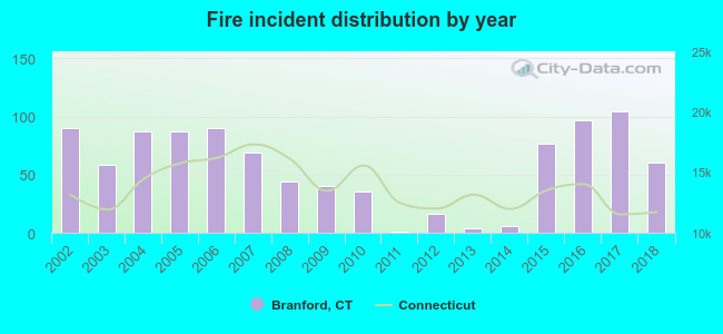 Based on the data from the years 2002 - 2018 the average number of fire incidents per year is 57. The highest number of reported fires - 104 took place in 2017, and the least - 1 in 2011. The data has a decreasing trend.
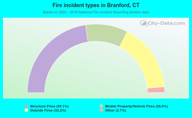 When looking into fire subcategories, the most reports belonged to: Structure Fires (45.1%), and Outside Fires (32.2%).
Fire-safe hotels and motels in Branford, Connecticut:
- Rodeway Inn & Suites, 81 Leetes Island Rd, Branford, Connecticut 06405 , Phone: (203) 481-4528, Fax: (203) 481-4528
- Americas Best Value Inn, 565 E Main St, Branford, Connecticut 06405 , Phone: (203) 488-4381, Fax: (203) 488-4568
- Holiday Inn Express Branford, 309 E Main St, Branford, Connecticut 06405 , Phone: (203) 488-4035
- Days Inn Branford, 325 E Main St, Branford, Connecticut 06405 , Phone: (203) 488-8314, Fax: (203) 483-6885
- Baymont Inn & Suites, 3 Business Park Dr, Branford, Connecticut 06405 , Phone: (203) 488-4991, Fax: (203) 488-6508
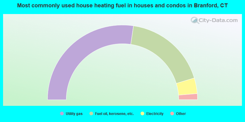
- 54.7%Utility gas
- 35.9%Fuel oil, kerosene, etc.
- 6.8%Electricity
- 1.7%Bottled, tank, or LP gas
- 0.7%Wood
- 0.2%Coal or coke
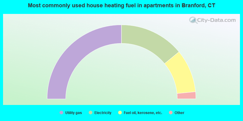
- 50.0%Utility gas
- 28.1%Electricity
- 18.8%Fuel oil, kerosene, etc.
- 2.2%Bottled, tank, or LP gas
- 0.4%Wood
- 0.3%Other fuel
- 0.2%Coal or coke
Branford compared to Connecticut state average:
- Unemployed percentage significantly below state average.
- Black race population percentage significantly below state average.
- Hispanic race population percentage significantly below state average.
- Median age above state average.
- Foreign-born population percentage below state average.
- Length of stay since moving in significantly above state average.
- Number of rooms per house significantly below state average.
- House age significantly below state average.
Branford on our top lists:
- #14 on the list of "Top 101 cities with the smallest racial income disparities between White and Black householders (with at least 200 householders)"
- #29 on the list of "Top 101 cities with largest percentage of males in occupations: life and physical scientists (population 5,000+)"
- #41 on the list of "Top 101 cities with largest percentage of females in occupations: rail and water transportation workers (population 5,000+)"
- #42 on the list of "Top 101 cities with the largest percentage of people in hospices or homes for chronically ill (population 1,000+)"
- #43 on the list of "Top 101 cities with largest percentage of females in industries: rail transportation (population 5,000+)"
- #55 on the list of "Top 101 cities with largest percentage of females in occupations: counselors, social workers, and other community and social service specialists (population 5,000+)"
- #81 on the list of "Top 101 cities with largest percentage of males in industries: broadcasting and telecommunications (population 5,000+)"
- #87 on the list of "Top 101 cities with largest percentage of males in occupations: special education teachers (population 5,000+)"
- #90 on the list of "Top 101 cities with largest percentage of males in occupations: communications equipment operators (population 5,000+)"
- #93 on the list of "Top 101 cities with the most residents born in United Kingdom (population 500+)"
- #93 on the list of "Top 101 cities with the most residents born in Yugoslavia (population 500+)"
- #93 on the list of "Top 101 cities with the most residents born in Asia, n.e.c. (population 500+)"
- #93 on the list of "Top 101 cities with the most residents born in Melanesia (population 500+)"
- #93 on the list of "Top 101 cities with the most residents born in Micronesia (population 500+)"
- #93 on the list of "Top 101 cities with the most residents born in Polynesia (population 500+)"
- #99 on the list of "Top 101 cities with largest percentage of females in occupations: physicians and surgeons (population 5,000+)"
- #99 on the list of "Top 101 cities with largest percentage of males in industries: personal and laundry services (population 5,000+)"
- #7 on the list of "Top 101 counties with highest percentage of residents voting for Obama (Democrat) in the 2012 Presidential Election"
- #14 on the list of "Top 101 counties with the most Catholic congregations"
- #36 on the list of "Top 101 counties with the most Catholic adherents"
- #38 on the list of "Top 101 counties with the lowest percentage of residents that keep firearms around their homes"
- #47 on the list of "Top 101 counties with the highest carbon monoxide air pollution readings in 2012 (ppm)"

|
|
Total of 734 patent applications in 2008-2024.