Cape Sable, Florida
Submit your own pictures of this place and show them to the world
- OSM Map
- General Map
- Google Map
- MSN Map

| Males: 32 | |
| Females: 23 |
| Median resident age: | 35.0 years |
| Florida median age: | 38.7 years |
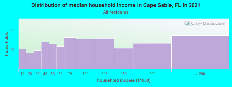
| Cape Sable: | $68,088 |
| FL: | $69,303 |
Estimated per capita income in 2022: $72,491 (it was $36,002 in 2000)
Mean prices in 2022: all housing units: over $1,000,000; detached houses: over $1,000,000; townhouses or other attached units: $834,357; in 2-unit structures: over $1,000,000; in 3-to-4-unit structures: $910,262; in 5-or-more-unit structures: $827,213; mobile homes: $313,121; occupied boats, rvs, vans, etc.: $138,332


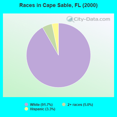
- 5591.7%White alone
- 35.0%Two or more races
- 23.3%Hispanic
 Recent articles from our blog. Our writers, many of them Ph.D. graduates or candidates, create easy-to-read articles on a wide variety of topics.
Current Local Time: EST time zone
Land area: 866.2 square miles.
Population density: 0.06 people per square mile (very low).
Nearest city with pop. 50,000+: Kendale Lakes-Lindgren Acres, FL (40.3 miles  , pop. 314,677).
Nearest city with pop. 1,000,000+: Houston, TX (934.5 miles , pop. 1,953,631).
Nearest cities:
), ), ), ), Latitude: 25.37 N, Longitude: 80.96 W

| Here: | 1.8% |
| Florida: | 2.9% |
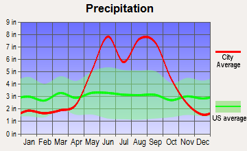
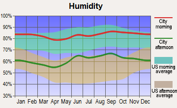
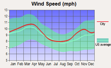
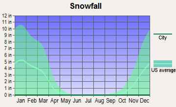
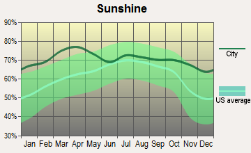
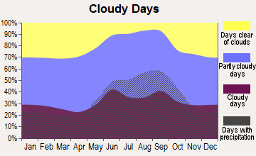
Average climate in Cape Sable, Florida
Based on data reported by over 4,000 weather stations
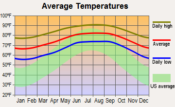
(lower is better)
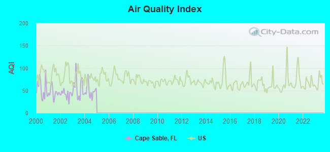
Air Quality Index (AQI) level in 2004 was 49.6. This is significantly better than average.
| City: | 49.6 |
| U.S.: | 72.6 |
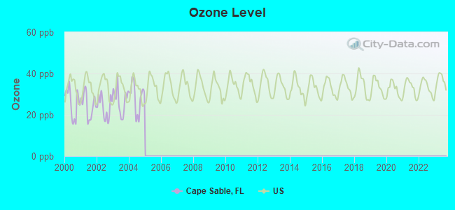
Ozone [ppb] level in 2004 was 28.5. This is about average. Closest monitor was 17.1 miles away from the city center.
| City: | 28.5 |
| U.S.: | 33.3 |
Tornado activity:
Cape Sable-area historical tornado activity is significantly below Florida state average. It is 65% smaller than the overall U.S. average.
On 6/17/1959, a category F3 (max. wind speeds 158-206 mph) tornado 49.0 miles away from the Cape Sable place center injured 77 people and caused between $500,000 and $5,000,000 in damages.
On 12/20/1973, a category F2 (max. wind speeds 113-157 mph) tornado 33.7 miles away from the place center injured 9 people and caused between $500,000 and $5,000,000 in damages.
Earthquake activity:
Cape Sable-area historical earthquake activity is significantly below Florida state average. It is 99% smaller than the overall U.S. average.On 9/10/2006 at 14:56:08, a magnitude 5.9 (5.9 MB, 5.5 MS, 5.8 MW, Class: Moderate, Intensity: VI - VII) earthquake occurred 358.5 miles away from the city center
On 2/22/1992 at 04:21:34, a magnitude 3.2 (3.2 MB, Depth: 6.2 mi, Class: Light, Intensity: II - III) earthquake occurred 145.7 miles away from Cape Sable center
On 3/31/1992 at 14:59:39, a magnitude 3.8 (3.8 MB, Depth: 3.1 mi) earthquake occurred 301.0 miles away from the city center
On 6/23/2016 at 17:20:29, a magnitude 3.8 (3.8 ML) earthquake occurred 333.0 miles away from the city center
On 7/16/2016 at 20:00:10, a magnitude 3.7 (3.7 MB) earthquake occurred 318.0 miles away from the city center
On 4/18/1997 at 14:57:35, a magnitude 3.9 (3.9 MB, Depth: 20.5 mi) earthquake occurred 350.3 miles away from the city center
Magnitude types: body-wave magnitude (MB), local magnitude (ML), surface-wave magnitude (MS), moment magnitude (MW)
Natural disasters:
The number of natural disasters in Monroe County (28) is a lot greater than the US average (15).Major Disasters (Presidential) Declared: 15
Emergencies Declared: 9
Causes of natural disasters: Hurricanes: 14, Tropical Storms: 6, Fires: 4, Floods: 3, Tornadoes: 2, Freeze: 1, Heavy Rain: 1, Storm: 1, Wind: 1, Other: 2 (Note: some incidents may be assigned to more than one category).
Colleges/universities with over 2000 students nearest to Cape Sable:
- Florida International University (about 45 miles; Miami, FL; Full-time enrollment: 41,234)
- Florida Career College-Miami (about 46 miles; Miami, FL; FT enrollment: 10,133)
- University of Miami (about 49 miles; Coral Gables, FL; FT enrollment: 13,674)
- Florida National University-Main Campus (about 53 miles; Hialeah, FL; FT enrollment: 4,106)
- Miami Dade College (about 56 miles; Miami, FL; FT enrollment: 53,787)
- AI Miami International University of Art and Design (about 57 miles; Miami, FL; FT enrollment: 3,578)
- DeVry University-Florida (about 58 miles; Miramar, FL; FT enrollment: 3,674)
Points of interest:
Notable locations in Cape Sable: Breezeswept Center (A), Camp Lonesome Mound (B), Cane Patch (C), Little Banana Patch (D), Flamingo Sewage Treatment Plant (E), Lostmans River Ranger Station (F), Flamingo Ranger Station (G), Casa Del Mar Light (H), Flamingo Campground (I). Display/hide their locations on the map
Lakes and swamps: Bear Lake (A), Big Boy Lake (B), Mrazek Pond (C), Mud Lake (D), Southwater (E), Mud Lakes (F), Northwater (G), Lake Ingraham (H). Display/hide their locations on the map
Streams, rivers, and creeks: Chatham River (A), Charley Creek (B), Rookery Branch (C), Rodgers River (D), Rodgers Creek (E), Rocky Creek (F), Roberts River (G), North River (H), Nomans River (I). Display/hide their locations on the map
Park in Cape Sable: Everglades National Park (1). Display/hide its location on the map
| This place: | 2.0 people |
| Florida: | 2.5 people |
| This place: | 50.0% |
| Whole state: | 65.2% |
| This place: | 0.0% |
| Whole state: | 7.3% |
No gay or lesbian households reported
For population 15 years and over in Cape Sable:
- Never married: 100.0%
- Now married: 0.0%
- Separated: 0.0%
- Widowed: 0.0%
- Divorced: 0.0%
For population 25 years and over in Cape Sable:
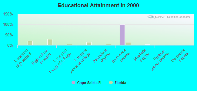
- High school or higher: 100.0%
- Bachelor's degree or higher: 100.0%
- Graduate or professional degree: 0.0%
- Mean travel time to work (commute): 5.0 minutes
| Here: | 0.0 |
| Florida average: | 12.6 |
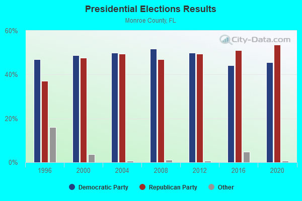
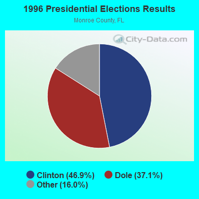
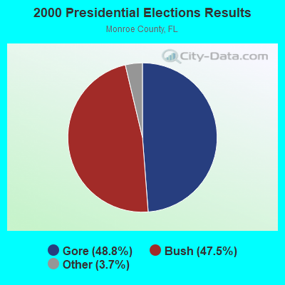
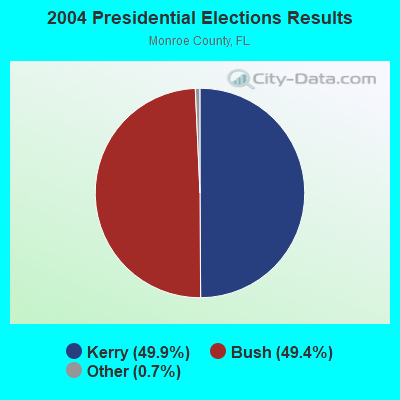
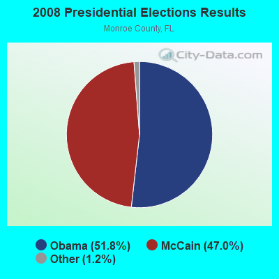
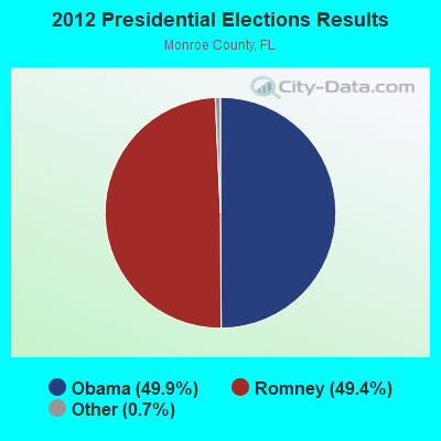
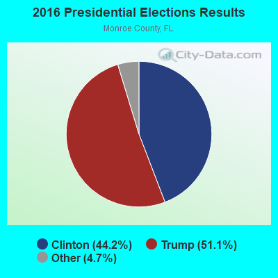
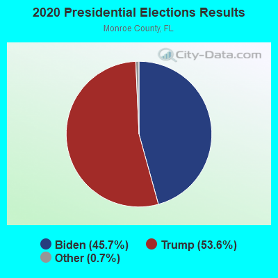
Graphs represent county-level data. Detailed 2008 Election Results
Religion statistics for Cape Sable, FL (based on Monroe County data)
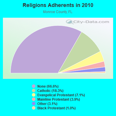
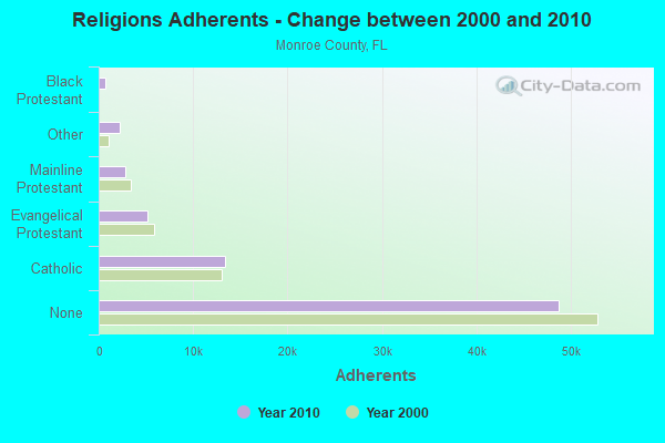
| Religion | Adherents | Congregations |
|---|---|---|
| Catholic | 13,346 | 5 |
| Evangelical Protestant | 5,156 | 39 |
| Mainline Protestant | 2,848 | 19 |
| Other | 2,264 | 12 |
| Black Protestant | 757 | 5 |
| Orthodox | 20 | 1 |
| None | 48,699 | - |
Food Environment Statistics:
| Monroe County: | 3.70 / 10,000 pop. |
| Florida: | 2.04 / 10,000 pop. |
| This county: | 2.06 / 10,000 pop. |
| Florida: | 1.28 / 10,000 pop. |
| This county: | 5.07 / 10,000 pop. |
| Florida: | 3.04 / 10,000 pop. |
| Monroe County: | 27.16 / 10,000 pop. |
| Florida: | 7.45 / 10,000 pop. |
| This county: | 9.1% |
| State: | 9.2% |
| Monroe County: | 20.8% |
| Florida: | 23.7% |
| Monroe County: | 9.0% |
| Florida: | 14.0% |
10.13% of this county's 2021 resident taxpayers lived in other counties in 2020 ($275,567 average adjusted gross income)
| Here: | 10.13% |
| Florida average: | 8.80% |
0.10% of residents moved from foreign countries ($696 average AGI)
Monroe County: 0.10% Florida average: 0.05%
Top counties from which taxpayers relocated into this county between 2020 and 2021:
| from Miami-Dade County, FL | |
| from Broward County, FL | |
| from Palm Beach County, FL |
10.71% of this county's 2020 resident taxpayers moved to other counties in 2021 ($90,566 average adjusted gross income)
| Here: | 10.71% |
| Florida average: | 7.45% |
0.05% of residents moved to foreign countries ($423 average AGI)
Monroe County: 0.05% Florida average: 0.04%
Top counties to which taxpayers relocated from this county between 2020 and 2021:
| to Miami-Dade County, FL | |
| to Broward County, FL | |
| to Lee County, FL |
Strongest AM radio stations in Cape Sable:
- WWFE (670 AM; 50 kW; MIAMI, FL; Owner: FENIX BROADCASTING CORP.)
- WVCG (1080 AM; 50 kW; CORAL GABLES, FL; Owner: RADIO ONE LICENSES, LLC)
- WQBA (1140 AM; 50 kW; MIAMI, FL; Owner: WQBA-AM LICENSE CORP.)
- WAQI (710 AM; 50 kW; MIAMI, FL; Owner: LICENSE CORPORATION #1)
- WSUA (1260 AM; 50 kW; MIAMI, FL; Owner: WSUA BROADCASTING CORPORATION)
- WNMA (1210 AM; 49 kW; MIAMI SPRINGS, FL; Owner: RADIO UNICA OF MIAMI LICENSE CORP.)
- WRFX (940 AM; 50 kW; MIAMI, FL; Owner: CLEAR CHANNEL BROADCASTING LICENSES, INC.)
- WRHC (1550 AM; 45 kW; CORAL GABLES, FL; Owner: WRHC BROADCASTING CORP.)
- WRHB (1020 AM; 9 kW; KENDALL, FL; Owner: NEW WORLD BROADCASTING, INC.)
- WJNA (640 AM; 38 kW; ROYAL PALM BEACH, FL; Owner: SOUTH FLORIDA RADIO, INC.)
- WWNN (1470 AM; 50 kW; POMPANO BEACH, FL; Owner: WWNN LICENSE, LLC)
- WAXY (790 AM; 5 kW; SOUTH MIAMI, FL; Owner: JEFFERSON-PILOT COMMUNICATIONS CO. OF FLORIDA)
- WFTL (850 AM; 50 kW; WEST PALM BEACH, FL; Owner: JAMES CRYSTAL ENTERPRISES II, L.L.C.)
Strongest FM radio stations in Cape Sable:
- WRTO (98.3 FM; GOULDS, FL; Owner: LICENSE CORPORATION #2)
- WMCU (89.7 FM; MIAMI, FL; Owner: TRINITY INTERNATIONAL FOUNDATION, INC.)
- WZMQ (106.3 FM; KEY LARGO, FL; Owner: SOUTH BROADCASTING SYSTEM, INC.)
- WXDJ (95.7 FM; NORTH MIAMI BEACH, FL; Owner: WXDJ LICENSING, INC.)
- WDNA (88.9 FM; MIAMI, FL; Owner: BASCOMB MEMORIAL BROADCASTING FOUNDATION)
TV broadcast stations around Cape Sable:
- WTVJ (Channel 6; MIAMI, FL; Owner: NBC STATIONS MANAGEMENT, INC.)
- WGEN-LP (Channel 55; MIAMI, FL; Owner: WDLP BROADCASTING COMPANY, LLC)
- W54BB (Channel 54; ROCK HARBOR, FL; Owner: WDLP BROADCASTING COMPANY, LLC)
- WEYS-LP (Channel 56; ROCK HARBOR, FL; Owner: CAYO HUESO NETWORKS, LLC)
- W32AB (Channel 32; MATECUMBE, FL; Owner: KEY COMMUNICATIONS OF TEXAS)
- WPMF-LP (Channel 31; MIAMI, FL; Owner: JAMES J. CHLADEK)
- W67AP (Channel 67; ROCK HARBOR, FL; Owner: MAKO COMMUNICATIONS, LLC)
Cape Sable compared to Florida state average:
- Median house value significantly below state average.
- Unemployed percentage significantly below state average.
- Black race population percentage significantly below state average.
- Hispanic race population percentage significantly below state average.
- Median age below state average.
- Foreign-born population percentage significantly below state average.
- Renting percentage below state average.
- Length of stay since moving in significantly above state average.
- Number of rooms per house significantly below state average.
- House age significantly below state average.
- Number of college students significantly below state average.
- Percentage of population with a bachelor's degree or higher significantly above state average.