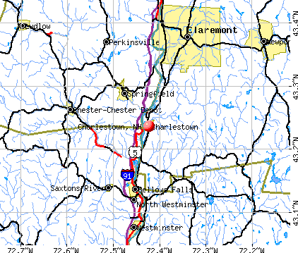
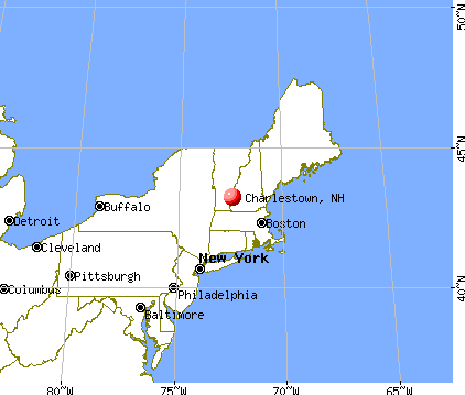
Charlestown, New Hampshire
Submit your own pictures of this place and show them to the world
- OSM Map
- General Map
- Google Map
- MSN Map
Population change since 2000: +0.6%
| Males: 554 | |
| Females: 598 |
| Median resident age: | 38.2 years |
| New Hampshire median age: | 43.3 years |
Zip codes: 03603.
| Charlestown: | |
| NH: |
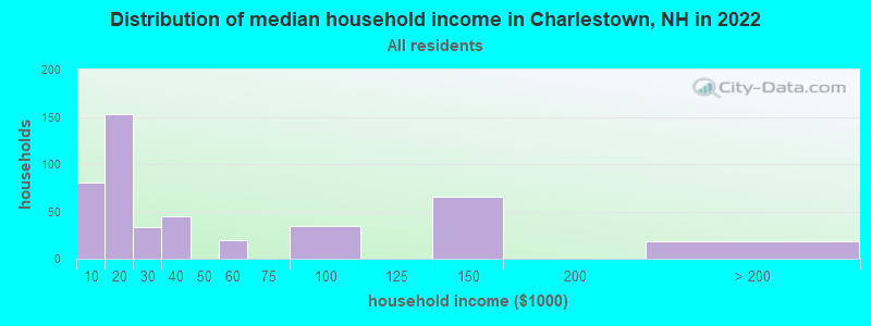
Estimated per capita income in 2022: $28,862 (it was $16,565 in 2000)
Charlestown CDP income, earnings, and wages data
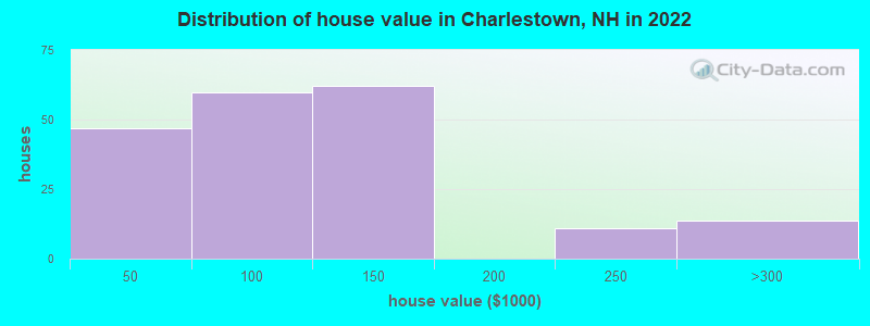
Estimated median house or condo value in 2022: $106,703 (it was $68,300 in 2000)
| Charlestown: | $106,703 |
| NH: | $384,700 |
Mean prices in 2022: all housing units: $337,766; detached houses: $372,023; townhouses or other attached units: $454,943; in 2-unit structures: $245,522; in 3-to-4-unit structures: $240,260; in 5-or-more-unit structures: $222,243; mobile homes: $88,713
Median gross rent in 2022: $1,242.
Detailed information about poverty and poor residents in Charlestown, NH
Compare current foreclosures near Charlestown, NH:
| Photo | Address | Area | Beds / Baths | Price | Details |
|---|---|---|---|---|---|

|
#1
Old Springfield Rd
Charlestown, NH 03603
|
1,848 sq. feet
|
1 baths 4 beds |
show details | |

|
#2
Morways Park
Charlestown, NH 03603
|
1,064 sq. feet
|
2 baths 2 beds |
show details | |

|
#3
Acworth Rd
Charlestown, NH 03603
|
1,826 sq. feet
|
1 baths 3 beds |
show details | |

|
#4
James St
Charlestown, NH 03603
|
1,032 sq. feet
|
2 baths 2 beds |
show details | |

|
#5
Taylor Hill Rd
Charlestown, NH 03603
|
2,226 sq. feet
|
2 baths 4 beds |
show details | |

|
#6
S Main St
Newport, NH 03773
|
100 sq. feet
|
1 baths 1 beds |
$60,000
|
show details |

|
#7
Elm St
Claremont, NH 03743
|
2,232 sq. feet
|
2 baths 4 beds |
show details | |

|
#8
S Koski Rd
Newport, NH 03773
|
1,596 sq. feet
|
2 baths 3 beds |
show details | |

|
#9
W Terrace St
Claremont, NH 03743
|
988 sq. feet
|
1 baths 3 beds |
show details | |

|
#10
Dutton District Rd
Springfield, VT 05156
|
1,770 sq. feet
|
1 baths 3 beds |
show details |
| Photo | Address | Area | Beds / Baths | Price | Details |
|---|---|---|---|---|---|

|
#11
Dodge Pl
Claremont, NH 03743
|
1,650 sq. feet
|
2 baths 3 beds |
show details | |

|
#12
Elm St
Claremont, NH 03743
|
2,176 sq. feet
|
2 baths 5 beds |
show details | |

|
#13
Pine Grove St
Claremont, NH 03743
|
2,304 sq. feet
|
1 baths 3 beds |
show details | |

|
#14
Byrd Ave
Claremont, NH 03743
|
1,904 sq. feet
|
1 baths 3 beds |
show details | |

|
#15
Blood Rd
Newport, NH 03773
|
- sq. feet
|
- baths - beds |
show details | |

|
#16
S Koski Rd
Newport, NH 03773
|
- sq. feet
|
- baths - beds |
show details | |

|
#17
Baine Way
Alstead, NH 03602
|
- sq. feet
|
- baths - beds |
show details | |

|
#18
Gilsum Mine Rd
Alstead, NH 03602
|
- sq. feet
|
- baths - beds |
show details | |

|
#19
W Pleasant St
Claremont, NH 03743
|
- sq. feet
|
- baths - beds |
show details | |

|
#20
Franklin St Frnt A
Claremont, NH 03743
|
- sq. feet
|
- baths - beds |
show details |
| Photo | Address | Area | Beds / Baths | Price | Details |
|---|---|---|---|---|---|

|
#21
Roberts Rd
Springfield, VT 05156
|
- sq. feet
|
- baths - beds |
show details | |

|
#22
Edgebrook Park
Bellows Falls, VT 05101
|
- sq. feet
|
- baths - beds |
show details | |

|
#23
Dogwood Ln
Springfield, VT 05156
|
- sq. feet
|
- baths - beds |
show details | |

|
#24
River St
Alstead, NH 03602
|
- sq. feet
|
- baths - beds |
show details | |

|
#25
Library Ave
Alstead, NH 03602
|
- sq. feet
|
- baths - beds |
show details | |

|
#26
Westview Ter
Springfield, VT 05156
|
- sq. feet
|
- baths - beds |
show details | |

|
#27
Bavier Ave
Windsor, VT 05089
|
- sq. feet
|
- baths - beds |
show details | |

|
#28
Upper Falls Rd
Perkinsville, VT 05151
|
- sq. feet
|
- baths - beds |
show details | |

|
#29
Taylor Dr
Springfield, VT 05156
|
- sq. feet
|
- baths - beds |
show details | |

|
#30
Center St
North Walpole, NH 03609
|
- sq. feet
|
- baths - beds |
show details |
| Photo | Address | Area | Beds / Baths | Price | Details |
|---|---|---|---|---|---|

|
#31
Mill St
Cavendish, VT 05142
|
- sq. feet
|
- baths - beds |
show details | |

|
#32
Parkview St
Newport, NH 03773
|
- sq. feet
|
- baths - beds |
show details | |

|
Check over 1 million property listings on Foreclosure.com!
|
browse all offers | |||


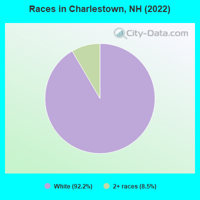
- 87092.2%White alone
- 808.5%Two or more races
Races in Charlestown detailed stats: ancestries, foreign born residents, place of birth
According to our research of New Hampshire and other state lists, there were 18 registered sex offenders living in Charlestown, New Hampshire as of April 26, 2024.
The ratio of all residents to sex offenders in Charlestown is 77 to 1.
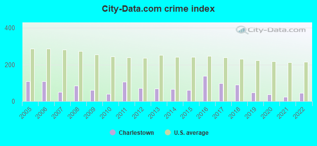
Type |
2009 |
2010 |
2011 |
2012 |
2013 |
2014 |
2015 |
2016 |
2017 |
2018 |
2019 |
2020 |
2021 |
2022 |
|---|---|---|---|---|---|---|---|---|---|---|---|---|---|---|
| Murders (per 100,000) | 0 (0.0) | 0 (0.0) | 0 (0.0) | 0 (0.0) | 0 (0.0) | 0 (0.0) | 0 (0.0) | 0 (0.0) | 0 (0.0) | 0 (0.0) | 0 (0.0) | 0 (0.0) | 0 (0.0) | 0 (0.0) |
| Rapes (per 100,000) | 1 (20.6) | 0 (0.0) | 2 (39.1) | 0 (0.0) | 2 (40.2) | 1 (20.2) | 0 (0.0) | 2 (40.2) | 0 (0.0) | 0 (0.0) | 0 (0.0) | 0 (0.0) | 0 (0.0) | 1 (20.2) |
| Robberies (per 100,000) | 0 (0.0) | 0 (0.0) | 0 (0.0) | 0 (0.0) | 0 (0.0) | 0 (0.0) | 2 (40.1) | 0 (0.0) | 2 (40.2) | 1 (20.0) | 0 (0.0) | 0 (0.0) | 0 (0.0) | 0 (0.0) |
| Assaults (per 100,000) | 1 (20.6) | 2 (39.1) | 6 (117.2) | 4 (78.6) | 2 (40.2) | 3 (60.6) | 4 (80.2) | 17 (342.1) | 15 (301.8) | 15 (300.7) | 8 (160.1) | 4 (79.8) | 1 (19.9) | 3 (60.6) |
| Burglaries (per 100,000) | 14 (288.7) | 13 (254.2) | 16 (312.4) | 13 (255.3) | 8 (160.8) | 11 (222.2) | 1 (20.0) | 7 (140.9) | 4 (80.5) | 5 (100.2) | 5 (100.0) | 7 (139.7) | 4 (79.6) | 3 (60.6) |
| Thefts (per 100,000) | 22 (453.7) | 18 (352.0) | 33 (644.4) | 36 (707.0) | 16 (321.7) | 23 (464.6) | 33 (661.3) | 29 (583.6) | 21 (422.5) | 19 (380.9) | 13 (260.1) | 8 (159.7) | 15 (298.6) | 15 (303.0) |
| Auto thefts (per 100,000) | 2 (41.2) | 1 (19.6) | 2 (39.1) | 7 (137.5) | 2 (40.2) | 3 (60.6) | 3 (60.1) | 3 (60.4) | 1 (20.1) | 1 (20.0) | 0 (0.0) | 3 (59.9) | 2 (39.8) | 1 (20.2) |
| Arson (per 100,000) | 0 (0.0) | 0 (0.0) | 0 (0.0) | 2 (39.3) | 0 (0.0) | 1 (20.2) | 1 (20.0) | 0 (0.0) | 0 (0.0) | 0 (0.0) | 1 (20.0) | 0 (0.0) | 0 (0.0) | 1 (20.2) |
| City-Data.com crime index | 62.3 | 41.3 | 105.4 | 72.9 | 67.6 | 67.3 | 60.7 | 138.7 | 96.6 | 90.0 | 49.4 | 36.9 | 24.7 | 46.3 |
The City-Data.com crime index weighs serious crimes and violent crimes more heavily. Higher means more crime, U.S. average is 246.1. It adjusts for the number of visitors and daily workers commuting into cities.
Crime rate in Charlestown detailed stats: murders, rapes, robberies, assaults, burglaries, thefts, arson
Full-time law enforcement employees in 2021, including police officers: 9 (5 officers - 3 male; 2 female).
| Officers per 1,000 residents here: | 1.00 |
| New Hampshire average: | 2.14 |
 Recent articles from our blog. Our writers, many of them Ph.D. graduates or candidates, create easy-to-read articles on a wide variety of topics.

 | Claremont,NH (11 replies) |
| Auto Repair in Claremont (4 replies) |
| relocating to lebanon/hanover area (5 replies) |
| Commute from Keene to Claremont (20 replies) |
| Claremont--any thoughts? (12 replies) |
| where should we move in nh? (15 replies) |
Latest news from Charlestown, NH collected exclusively by city-data.com from local newspapers, TV, and radio stations
Ancestries: French (21.2%), Scotch-Irish (16.3%), French Canadian (13.2%), Scottish (13.2%), Dutch (11.3%), Irish (11.3%).
Current Local Time: EST time zone
Incorporated in 1753
Elevation: 115 feet
Land area: 0.84 square miles.
Population density: 1,366 people per square mile (low).
16 residents are foreign born
| This place: | 1.4% |
| New Hampshire: | 4.4% |
| Charlestown CDP: | 3.5% ($2,366) |
| New Hampshire: | 2.3% ($2,946) |
Nearest city with pop. 50,000+: Manchester, NH  (52.0 miles , pop. 107,006).
Nearest city with pop. 200,000+: Boston, MA (92.7 miles , pop. 589,141).
Nearest city with pop. 1,000,000+: Bronx, NY (181.3 miles , pop. 1,332,650).
Nearest cities:
), ), ), ), )Latitude: 43.24 N, Longitude: 72.42 W
Area code: 603
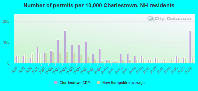
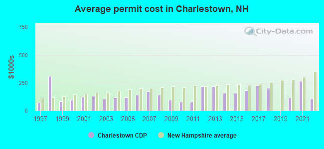
Single-family new house construction building permits:
- 2022: 18 buildings, average cost: $107,500
- 2021: 3 buildings, average cost: $265,000
- 2020: 4 buildings, average cost: $114,800
- 2018: 1 building, cost: $205,000
- 2017: 3 buildings, average cost: $226,700
- 2016: 2 buildings, average cost: $182,500
- 2015: 4 buildings, average cost: $158,800
- 2014: 4 buildings, average cost: $158,800
- 2013: 5 buildings, average cost: $217,000
- 2012: 5 buildings, average cost: $217,000
- 2011: 1 building, cost: $80,000
- 2010: 2 buildings, average cost: $80,000
- 2009: 8 buildings, average cost: $97,300
- 2008: 5 buildings, average cost: $141,000
- 2007: 12 buildings, average cost: $172,600
- 2006: 10 buildings, average cost: $144,000
- 2005: 10 buildings, average cost: $120,200
- 2004: 18 buildings, average cost: $117,800
- 2003: 13 buildings, average cost: $107,200
- 2002: 7 buildings, average cost: $132,300
- 2001: 6 buildings, average cost: $122,800
- 2000: 9 buildings, average cost: $97,100
- 1999: 3 buildings, average cost: $85,000
- 1998: 4 buildings, average cost: $310,900
- 1997: 4 buildings, average cost: $71,300
| Here: | 2.2% |
| New Hampshire: | 2.5% |
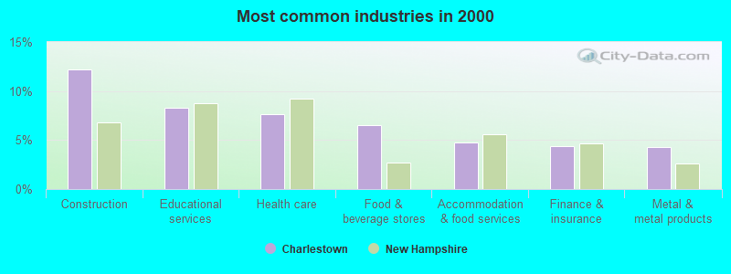
- Construction (12.2%)
- Educational services (8.2%)
- Health care (7.7%)
- Food & beverage stores (6.5%)
- Accommodation & food services (4.7%)
- Finance & insurance (4.4%)
- Metal & metal products (4.3%)
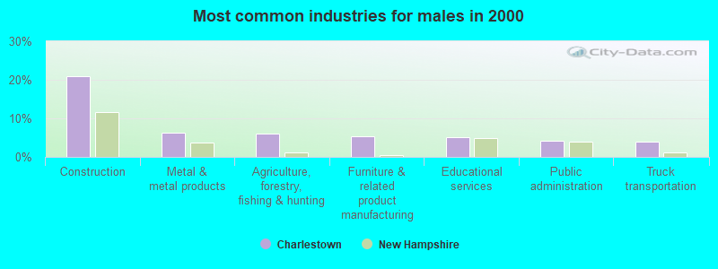
- Construction (20.9%)
- Metal & metal products (6.3%)
- Agriculture, forestry, fishing & hunting (6.1%)
- Furniture & related product manufacturing (5.3%)
- Educational services (5.0%)
- Public administration (4.2%)
- Truck transportation (4.0%)
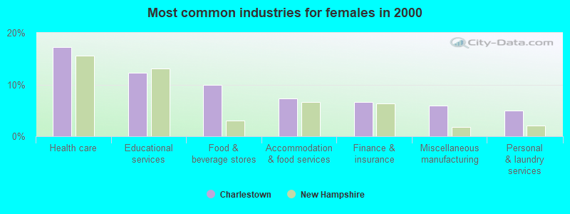
- Health care (17.3%)
- Educational services (12.3%)
- Food & beverage stores (10.0%)
- Accommodation & food services (7.3%)
- Finance & insurance (6.6%)
- Miscellaneous manufacturing (6.0%)
- Personal & laundry services (5.0%)
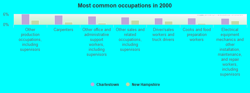
- Other production occupations, including supervisors (6.0%)
- Carpenters (5.4%)
- Other office and administrative support workers, including supervisors (4.9%)
- Other sales and related occupations, including supervisors (4.4%)
- Driver/sales workers and truck drivers (3.8%)
- Cooks and food preparation workers (3.8%)
- Electrical equipment mechanics and other installation, maintenance, and repair workers, including supervisors (3.7%)
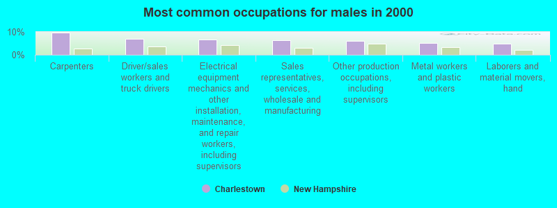
- Carpenters (9.8%)
- Driver/sales workers and truck drivers (6.9%)
- Electrical equipment mechanics and other installation, maintenance, and repair workers, including supervisors (6.6%)
- Sales representatives, services, wholesale and manufacturing (6.3%)
- Other production occupations, including supervisors (6.1%)
- Metal workers and plastic workers (5.0%)
- Laborers and material movers, hand (4.8%)
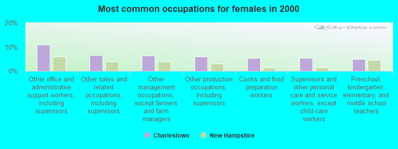
- Other office and administrative support workers, including supervisors (11.0%)
- Other sales and related occupations, including supervisors (6.6%)
- Other management occupations, except farmers and farm managers (6.3%)
- Other production occupations, including supervisors (6.0%)
- Cooks and food preparation workers (5.3%)
- Supervisors and other personal care and service workers, except child care workers (5.3%)
- Preschool, kindergarten, elementary, and middle school teachers (5.0%)
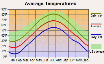
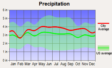
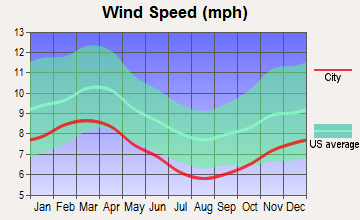
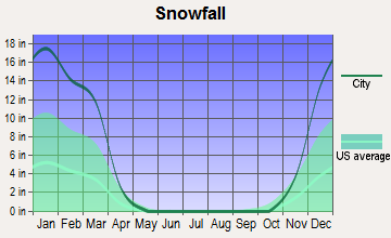
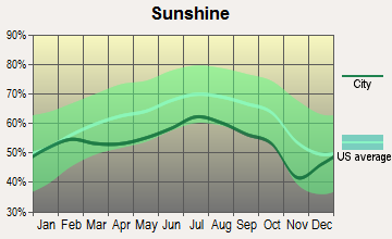
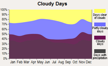
Average climate in Charlestown, New Hampshire
Based on data reported by over 4,000 weather stations

|
|

(lower is better)
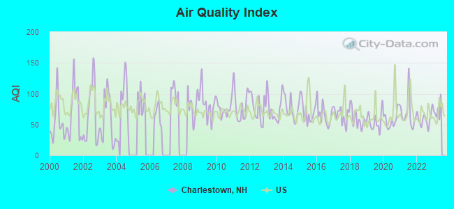
Air Quality Index (AQI) level in 2022 was 59.0. This is better than average.
| City: | 59.0 |
| U.S.: | 72.6 |
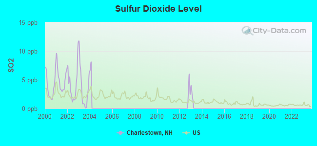
Sulfur Dioxide (SO2) [ppb] level in 2003 was 3.66. This is significantly worse than average. Closest monitor was 4.7 miles away from the city center.
| City: | 3.66 |
| U.S.: | 1.51 |
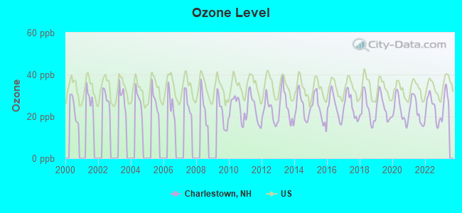
Ozone [ppb] level in 2022 was 23.7. This is significantly better than average. Closest monitor was 9.9 miles away from the city center.
| City: | 23.7 |
| U.S.: | 33.3 |
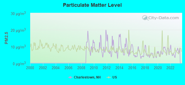
Particulate Matter (PM2.5) [µg/m3] level in 2022 was 5.97. This is better than average. Closest monitor was 9.9 miles away from the city center.
| City: | 5.97 |
| U.S.: | 8.11 |
Tornado activity:
Charlestown-area historical tornado activity is slightly above New Hampshire state average. It is 44% smaller than the overall U.S. average.
On 8/20/1968, a category F3 (max. wind speeds 158-206 mph) tornado 21.2 miles away from the Charlestown place center injured one person and caused between $5000 and $50,000 in damages.
On 7/9/1962, a category F2 (max. wind speeds 113-157 mph) tornado 4.5 miles away from the place center caused between $500 and $5000 in damages.
Earthquake activity:
Charlestown-area historical earthquake activity is significantly above New Hampshire state average. It is 70% smaller than the overall U.S. average.On 10/7/1983 at 10:18:46, a magnitude 5.3 (5.1 MB, 5.3 LG, 5.1 ML, Class: Moderate, Intensity: VI - VII) earthquake occurred 108.2 miles away from Charlestown center
On 4/20/2002 at 10:50:47, a magnitude 5.3 (5.3 ML, Depth: 3.0 mi) earthquake occurred 108.8 miles away from Charlestown center
On 4/20/2002 at 10:50:47, a magnitude 5.2 (5.2 MB, 4.2 MS, 5.2 MW, 5.0 MW) earthquake occurred 108.0 miles away from the city center
On 1/19/1982 at 00:14:42, a magnitude 4.7 (4.5 MB, 4.7 MD, 4.5 LG, Class: Light, Intensity: IV - V) earthquake occurred 45.2 miles away from Charlestown center
On 10/16/2012 at 23:12:25, a magnitude 4.7 (4.7 ML, Depth: 10.0 mi) earthquake occurred 92.2 miles away from the city center
On 6/17/1991 at 08:53:16, a magnitude 4.1 (4.0 MB, 4.0 LG, Depth: 3.1 mi) earthquake occurred 121.6 miles away from the city center
Magnitude types: regional Lg-wave magnitude (LG), body-wave magnitude (MB), duration magnitude (MD), local magnitude (ML), surface-wave magnitude (MS), moment magnitude (MW)
Natural disasters:
The number of natural disasters in Sullivan County (28) is a lot greater than the US average (15).Major Disasters (Presidential) Declared: 18
Emergencies Declared: 9
Causes of natural disasters: Storms: 13, Floods: 12, Snows: 4, Winter Storms: 4, Hurricanes: 3, Blizzard: 1, Ice Storm: 1, Landslide: 1, Snowfall: 1, Snowstorm: 1, Tropical Storm: 1, Wind: 1, Other: 1 (Note: some incidents may be assigned to more than one category).
Hospitals and medical centers near Charlestown:
- SPRINGFIELD HEALTH AND REHAB (Nursing Home, about 7 miles away; SPRINGFIELD, VT)
- MCGIRR NURSING HOME (Nursing Home, about 8 miles away; BELLOWS FALLS, VT)
- VALLEY REGIONAL HOSPITAL Critical Access Hospitals (about 12 miles away; CLAREMONT, NH)
- ELM WOOD CENTER AT CLAREMONT (Nursing Home, about 12 miles away; CLAREMONT, NH)
- CONNECTICUT VALLEY HOME CARE (Home Health Center, about 14 miles away; NEWPORT, NH)
- TRUSTING HANDS (Home Health Center, about 14 miles away; NEWPORT, NH)
- CEDAR HILL HEALTH CARE CENTER (Nursing Home, about 14 miles away; WINDSOR, VT)
Amtrak stations near Charlestown:
- 8 miles: BELLOWS FALLS (DEPOT ST.) . Services: enclosed waiting area, public restrooms, public payphones, free short-term parking, free long-term parking, call for taxi service.
- 10 miles: CLAREMONT (PLAINS RD.) . Services: public payphones, free short-term parking, free long-term parking.
- 18 miles: WINDSOR-MOUNT ASCUTNEY (WINDSOR, DEPOT AVE.) . Services: public payphones, free short-term parking, free long-term parking, call for car rental service, intercity bus service.
Colleges/universities with over 2000 students nearest to Charlestown:
- Keene State College (about 23 miles; Keene, NH; Full-time enrollment: 5,098)
- Dartmouth College (about 34 miles; Hanover, NH; FT enrollment: 6,030)
- Franklin Pierce University (about 37 miles; Rindge, NH; FT enrollment: 2,139)
- NHTI-Concord's Community College (about 45 miles; Concord, NH; FT enrollment: 2,865)
- Castleton State College (about 46 miles; Castleton, VT; FT enrollment: 2,079)
- Saint Anselm College (about 50 miles; Manchester, NH; FT enrollment: 2,059)
- Mount Wachusett Community College (about 50 miles; Gardner, MA; FT enrollment: 3,143)
Public elementary/middle schools in Charlestown:
- CHARLESTOWN PRIMARY SCHOOL (Students: 263, Location: 84 E. STREET EXT., Grades: PK-5)
- CHARLESTOWN MIDDLE SCHOOL (Students: 192, Location: 307 MAIN ST., Grades: 6-8)
- N. CHARLESTOWN COMMUNITY SCHOOL (Students: 51, Location: 509 RIVER RD., Grades: 1-5)
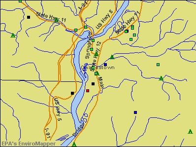
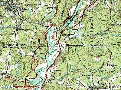
Points of interest:
Notable locations in Charlestown: Charlestown Fire Department (A), Silsby Free Public Library (B), Charlestown Town Hall (C). Display/hide their locations on the map
Churches in Charlestown include: Saint Lukes Episcopal Church (A), South Parish Unitarian Church (B). Display/hide their locations on the map
Cemetery: Charlestown Cemetery (1). Display/hide its location on the map
Reservoir: Clay Brook Reservoir (A). Display/hide its location on the map
Streams, rivers, and creeks: Clay Brook (A). Display/hide its location on the map
Park in Charlestown: Charlestown Main Street Historic District (1). Display/hide its location on the map
Tourist attractions: Fort at No 4 (Museums; Springfield Road), Party Time Family Fun Zone (Arcades & Amusements; 3849 Claremont Rd).
Hotel: Red Robin Motel (402 Old Claremont Road).
Birthplace of: Alexander Hamilton Willard - Explorer, DeForest Richards - Politician, James Broderick - Actor, Ralph Metcalf - Politician, William E. Corbin - Businessman.
Drinking water stations with addresses in Charlestown and their reported violations in the past:
NORTH CHARLESTOWN WATER DEPT (Population served: 325, Groundwater):Past health violations:
- MCL, Average - Between JUL-2007 and SEP-2007, Contaminant: Arsenic. Follow-up actions: St Public Notif requested (OCT-09-2007), St Violation/Reminder Notice (OCT-09-2007), St Public Notif received (NOV-01-2007), St Compliance achieved (JUN-04-2008)
- MCL, Average - Between APR-2007 and JUN-2007, Contaminant: Arsenic. Follow-up actions: St Public Notif requested (MAY-31-2007), St Violation/Reminder Notice (MAY-31-2007), St Public Notif received (JUN-27-2007), St Compliance achieved (JUN-04-2008)
- MCL, Average - Between JAN-2007 and MAR-2007, Contaminant: Arsenic. Follow-up actions: St Violation/Reminder Notice (APR-10-2007), St Compliance achieved (JUN-04-2008)
Drinking water stations with addresses in Charlestown that have no violations reported:
- CHARLESTOWN WATER WORKS (Population served: 2,500, Primary Water Source Type: Groundwater)
| This place: | 2.3 people |
| New Hampshire: | 2.5 people |
| This place: | 62.1% |
| Whole state: | 66.3% |
| This place: | 11.1% |
| Whole state: | 8.3% |
Likely homosexual households (counted as self-reported same-sex unmarried-partner households)
- Lesbian couples: 0.6% of all households
- Gay men: 0.4% of all households
13 people in workers' group living quarters and job corps centers in 2010
12 people in nursing homes in 2000
Banks with branches in Charlestown (2011 data):
- Connecticut River Bank, National Association: Charlestown Branch at 245 Main Street, branch established on 1996/10/01. Info updated 2008/07/16: Bank assets: $267.5 mil, Deposits: $242.4 mil, headquarters in Springfield, VT, positive income, Commercial Lending Specialization, 11 total offices, Holding Company: Connecticut River Bancorp, Inc.
- Claremont Savings Bank: Charlestown Branch at 135 Main Street, branch established on 1983/09/27. Info updated 2007/09/26: Bank assets: $320.2 mil, Deposits: $259.6 mil, headquarters in Claremont, NH, positive income, Mortgage Lending Specialization, 5 total offices
For population 15 years and over in Charlestown:
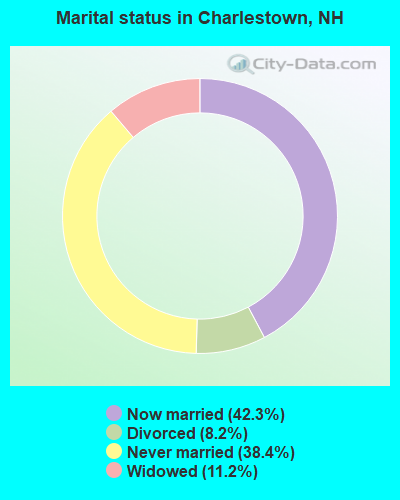
- Never married: 38.4%
- Now married: 42.3%
- Separated: 0.0%
- Widowed: 11.2%
- Divorced: 8.2%
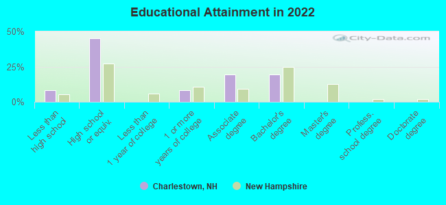
For population 25 years and over in Charlestown:
- High school or higher: 91.4%
- Bachelor's degree or higher: 18.4%
- Graduate or professional degree: 0.2%
- Unemployed: 5.6%
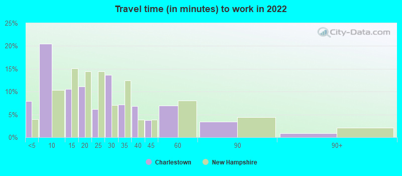
- Mean travel time to work (commute): 17.9 minutes
| Here: | 8.2 |
| New Hampshire average: | 10.3 |
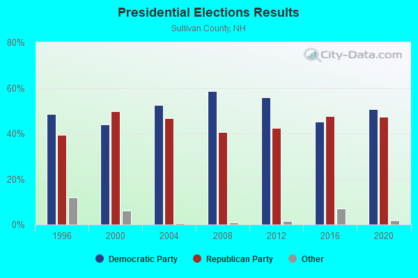
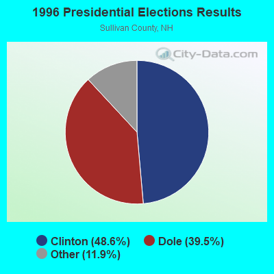
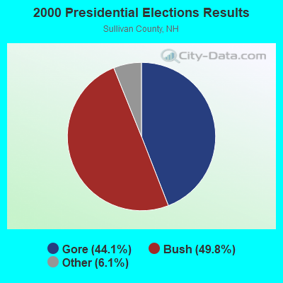
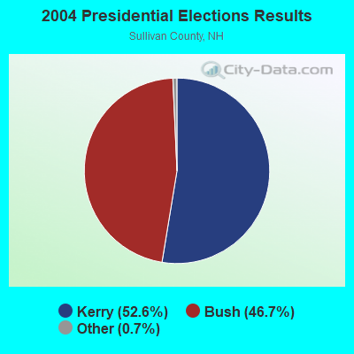
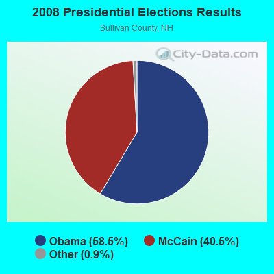
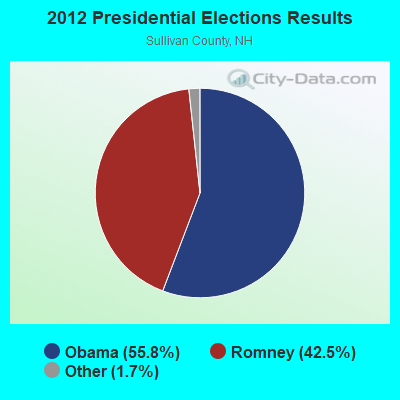
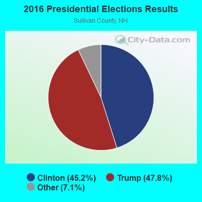
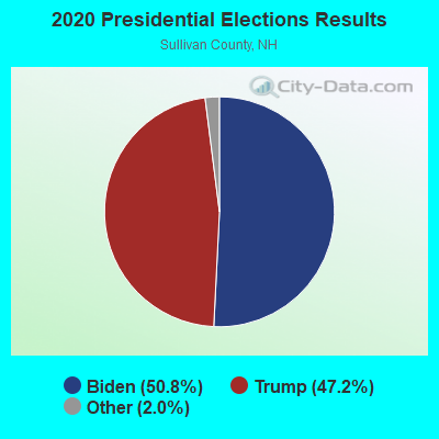
Graphs represent county-level data. Detailed 2008 Election Results
Religion statistics for Charlestown, NH (based on Sullivan County data)
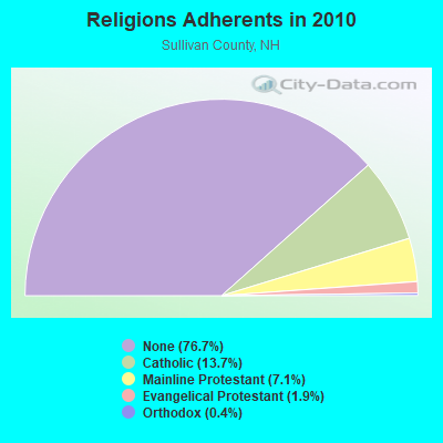
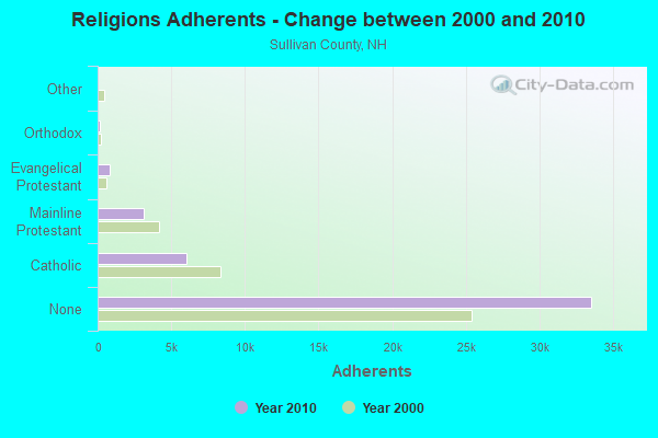
| Religion | Adherents | Congregations |
|---|---|---|
| Catholic | 6,008 | 1 |
| Mainline Protestant | 3,118 | 28 |
| Evangelical Protestant | 849 | 14 |
| Orthodox | 185 | 2 |
| Other | 29 | 2 |
| None | 33,553 | - |
Food Environment Statistics:
| This county: | 1.41 / 10,000 pop. |
| New Hampshire: | 2.14 / 10,000 pop. |
| Sullivan County: | 0.23 / 10,000 pop. |
| State: | 0.15 / 10,000 pop. |
| Sullivan County: | 1.41 / 10,000 pop. |
| New Hampshire: | 1.78 / 10,000 pop. |
| Sullivan County: | 6.34 / 10,000 pop. |
| New Hampshire: | 4.02 / 10,000 pop. |
| Sullivan County: | 4.93 / 10,000 pop. |
| New Hampshire: | 9.70 / 10,000 pop. |
| Sullivan County: | 8.0% |
| State: | 7.6% |
| Sullivan County: | 26.9% |
| State: | 24.4% |
| This county: | 18.5% |
| New Hampshire: | 15.9% |
Health and Nutrition:
| This city: | 48.6% |
| New Hampshire: | 51.2% |
| This city: | 48.0% |
| New Hampshire: | 49.1% |
| Here: | 28.6 |
| New Hampshire: | 28.5 |
| This city: | 21.6% |
| New Hampshire: | 20.9% |
| Charlestown: | 13.9% |
| New Hampshire: | 9.3% |
| This city: | 7.0 |
| New Hampshire: | 6.9 |
| Charlestown: | 38.7% |
| New Hampshire: | 34.3% |
| This city: | 55.7% |
| New Hampshire: | 58.1% |
| Charlestown: | 83.1% |
| New Hampshire: | 79.1% |
More about Health and Nutrition of Charlestown, NH Residents
| Businesses in Charlestown, NH | ||||
| Name | Count | Name | Count | |
|---|---|---|---|---|
| FedEx | 1 | U-Haul | 1 | |
| True Value | 1 | UPS | 1 | |
Strongest AM radio stations in Charlestown:
- WNBX (1480 AM; 5 kW; SPRINGFIELD, VT)
- WNTK (1020 AM; 10 kW; NEWPORT, NH; Owner: KOOR COMMUNICATIONS, INC.)
- WNNZ (640 AM; 50 kW; WESTFIELD, MA; Owner: CLEAR CHANNEL BROADCASTING LICENSES, INC.)
- WCRN (830 AM; 50 kW; WORCESTER, MA; Owner: CARTER BROADCASTING CORPORATION)
- WRKO (680 AM; 50 kW; BOSTON, MA; Owner: ENTERCOM BOSTON LICENSE, LLC)
- WKBK (1290 AM; 5 kW; KEENE, NH; Owner: SAGA COMMUNICATIONS OF NEW ENGLAND, LLC)
- WGY (810 AM; 50 kW; SCHENECTADY, NY; Owner: CLEAR CHANNEL BROADCASTING LICENSES, INC.)
- WTSV (1230 AM; 1 kW; CLAREMONT, NH; Owner: GREAT NORTHERN RADIO, L.L.C.)
- WEEI (850 AM; 50 kW; BOSTON, MA; Owner: ENTERCOM BOSTON LICENSE, LLC)
- WVNE (760 AM; daytime; 25 kW; LEICESTER, MA; Owner: BLOUNT MASSCOM, INC.)
- WKOX (1200 AM; 50 kW; FRAMINGHAM, MA; Owner: CAPSTAR TX LIMITED PARTNERSHIP)
- WBIX (1060 AM; 40 kW; NATICK, MA; Owner: LANGER BROADCASTING CORPORATION)
- WALE (990 AM; 50 kW; GREENVILLE, RI; Owner: NORTH AMERICAN BROADCASTING CO., INC.)
Strongest FM radio stations in Charlestown:
- WHDQ (106.1 FM; CLAREMONT, NH; Owner: GREAT NORTHERN RADIO, L.L.C.)
- WZSH (107.1 FM; BELLOWS FALLS, VT; Owner: GREAT NORTHERN RADIO, L.L.C.)
- WVPR (89.5 FM; WINDSOR, VT; Owner: VERMONT PUBLIC RADIO)
- WXKK (93.5 FM; SPRINGFIELD, VT; Owner: CLEAR CHANNEL BROADCASTING LICENSES, INC.)
- WVRR (101.7 FM; NEWPORT, NH; Owner: CAPSTAR TX LIMITED PARTNERSHIP)
- WKNE (103.7 FM; KEENE, NH; Owner: SAGA COMMUNICATIONS OF NEW ENGLAND, LLC)
- WEVN (90.7 FM; KEENE, NH; Owner: NEW HAMPSHIRE PUBLIC RADIO, INC.)
- WJJR (98.1 FM; RUTLAND, VT; Owner: 6 JOHNSON ROAD LICENSES, INC.)
- WZRT (97.1 FM; RUTLAND, VT; Owner: CAPSTAR TX LIMITED PARTNERSHIP)
- WCFR-FM (96.3 FM; WALPOLE, NH; Owner: GREAT NORTHERN RADIO, LLC)
- WEBK (105.3 FM; KILLINGTON, VT; Owner: 6 JOHNSON ROAD LICENSES, INC.)
- WEQX (102.7 FM; MANCHESTER, VT; Owner: NORTHSHIRE COMMUNICATIONS, INC.)
- WJAN (95.1 FM; SUNDERLAND, VT; Owner: 6 JOHNSON ROAD LICENSES, INC.)
- WGLV (91.7 FM; WOODSTOCK, VT; Owner: CHRISTIAN MINISTRIES INC)
- WHDQ-FM1 (106.1 FM; RUTLAND, VT; Owner: GREAT NORTHERN RADIO, L.L.C.)
- WVAY (100.7 FM; WILMINGTON, VT; Owner: GREAT NORTHERN RADIO, L.L.C.)
- WCMK (91.9 FM; PUTNEY, VT; Owner: CHRISTIAN MINISTRIES INC)
- WFEX (92.1 FM; PETERBOROUGH, NH; Owner: FNX BROADCASTING OF NEW HAMPSHIRE LLC)
- WEVH (91.3 FM; HANOVER, NH; Owner: NEW HAMPSHIRE PUBLIC RADIO INC)
- WNTK-FM (99.7 FM; NEW LONDON, NH; Owner: SHEILA E. VINIKOOR)
TV broadcast stations around Charlestown:
- WEKW-TV (Channel 52; KEENE, NH; Owner: UNIVERSITY OF NEW HAMPSHIRE)
- WVTA (Channel 41; WINDSOR, VT; Owner: VERMONT ETV, INC.)
- WNNE (Channel 31; HARTFORD, VT; Owner: HEARST-ARGYLE STATIONS, INC.)
- W17CI (Channel 17; CLAREMONT, NH; Owner: UPPER VALLEY BROADCASTING, LLC)
- Charlestown, New Hampshire
- Fatal accident count27
- Vehicles involved in fatal accidents44
- Fatal accidents involving drunk persons:10
- Fatalities31
- Persons involved in fatal accidents64
- Pedestrians involved in fatal accidents3
- New Hampshire average
- Fatal accident count2295
- Vehicles involved in fatal accidents3409
- Fatal accidents involving drunk persons767
- Fatalities2499
- Persons involved in fatal accidents5169
- Pedestrians involved in fatal accidents232
- National Bridge Inventory (NBI) Statistics
- 6Number of bridges
- 92ft / 28.3mTotal length
- $18,852,000Total costs
- 16,588Total average daily traffic
- 798Total average daily truck traffic
- 24,547Total future (year 2042) average daily traffic
FCC Registered Antenna Towers:
12 (See the full list of FCC Registered Antenna Towers in Charlestown)FCC Registered Broadcast Land Mobile Towers:
8 (See the full list of FCC Registered Broadcast Land Mobile Towers in Charlestown, NH)FCC Registered Amateur Radio Licenses:
43 (See the full list of FCC Registered Amateur Radio Licenses in Charlestown)FAA Registered Aircraft:
6- Aircraft: SAWYER DENNIS KITFOX (Category: Land, Seats: 2, Weight: Up to 12,499 Pounds), Engine: BOMBARDIER ROTAX (ALL) (Reciprocating)
N-Number: 73DS, N73DS, N-73DS, Serial Number: 366, Airworthiness Date: 12/28/1993, Certificate Issue Date: 03/10/2014
Registrant (Individual): Gordon J Nash, 131 Pecor Rd, Charlestown, NH 03603 - Aircraft: MOONEY M20M (Category: Land, Seats: 4, Weight: Up to 12,499 Pounds), Engine: LYCOMING TI0-540 SER (310 HP) (Reciprocating)
N-Number: 9127M, N9127M, N-9127M, Serial Number: 27-0299, Year manufactured: 2000, Airworthiness Date: 07/14/2000, Certificate Issue Date: 03/28/2016
Registrant (Individual): Edward C Farris, 191 Scenic Hill Rd, Charlestown, NH 03603 - Aircraft: ANTARES US MA 34R 912 RANGER (Category: Amphibian, Seats: 2, Weight: Up to 12,499 Pounds), Engine: ROTAX 912UL SERIES (80 HP) (4 Cycle)
N-Number: 2356W, N2356W, N-2356W, Serial Number: 028816 PCM, Year manufactured: 2005, Airworthiness Date: 01/21/2010, Certificate Issue Date: 03/16/2017
Registrant (Individual): Ronald V Gilson, 707 Calavant Hill Rd, Charlestown, NH 03603 - Aircraft: ALEXANDER SCHLEICHER GMBH & CO ASW 27-18 E (Category: Land, Seats: 2, Weight: Up to 12,499 Pounds), Engine: SOLO 2350 SER (26 HP) (Reciprocating)
N-Number: 129TD, N129TD, N-129TD, Serial Number: 29567, Year manufactured: 2008, Airworthiness Date: 11/14/2008, Certificate Issue Date: 11/13/2008
Registrant (Corporation): Emerald Eagle LLC, Po Box 921, Charlestown, NH 03603
Deregistered: Cancel Date: 01/11/2018 - Aircraft: REINHART K W/WILSON C A XP503 (Category: Land, Seats: 2, Weight: Up to 12,499 Pounds), Engine: Reciprocating
N-Number: 2203Z, N2203Z, N-2203Z, Serial Number: DRO976, Certificate Issue Date: 05/25/1994
Registrant (Co-Owned): Kenneth W Reinhart, 1189 N Hemlock Rd, Charlestown, NH 03603, Other Owners: Craig A Wilson
Deregistered: Cancel Date: 10/20/2017 - Aircraft: BABY ACE D (Category: Land, Weight: Up to 12,499 Pounds, Speed: 82 mph), Engine: CONT MOTOR A&C65 SERIES (65 HP) (Reciprocating)
N-Number: 6112, N6112, N-6112, Serial Number: 101, Year manufactured: 1969, Airworthiness Date: 06/18/1980, Certificate Issue Date: 06/08/1988
Registrant (Individual): Normand B Paulhus, 1334 Old Claremont Rd, Charlestown, NH 03603
2007 - 2018 National Fire Incident Reporting System (NFIRS) incidents
- Fire incident types reported to NFIRS in Charlestown, NH
- 9350.5%Structure Fires
- 7138.6%Outside Fires
- 126.5%Mobile Property/Vehicle Fires
- 84.3%Other
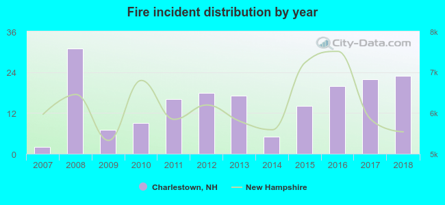 Based on the data from the years 2007 - 2018 the average number of fires per year is 15. The highest number of fires - 31 took place in 2008, and the least - 2 in 2007. The data has an increasing trend.
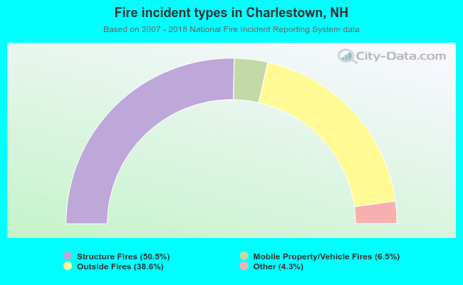 When looking into fire subcategories, the most incidents belonged to: Structure Fires (50.5%), and Outside Fires (38.6%).
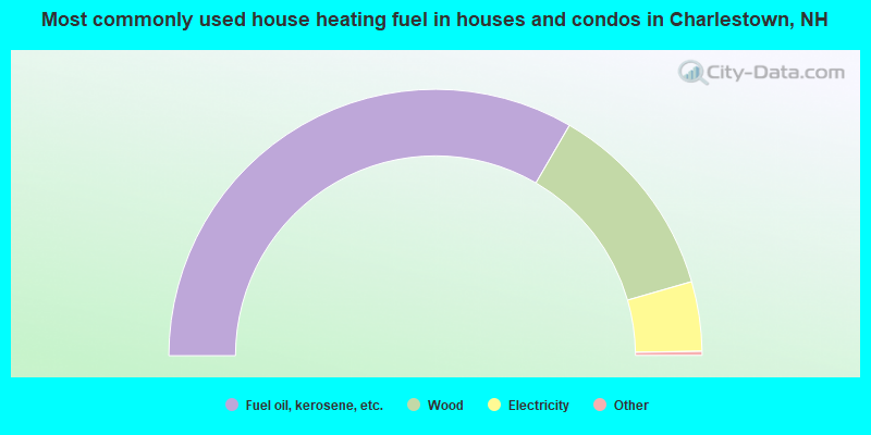
- 67.1%Fuel oil, kerosene, etc.
- 24.4%Wood
- 8.5%Electricity
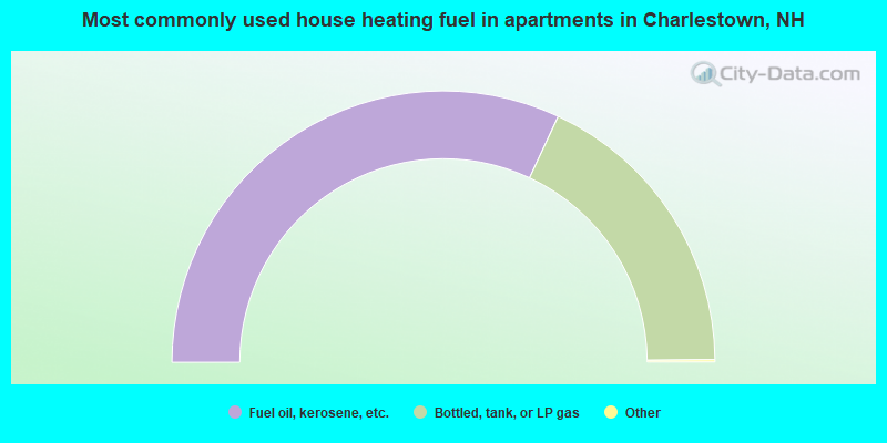
- 64.1%Fuel oil, kerosene, etc.
- 35.9%Bottled, tank, or LP gas
Charlestown compared to New Hampshire state average:
- Median household income significantly below state average.
- Median house value significantly below state average.
- Unemployed percentage below state average.
- Black race population percentage significantly below state average.
- Hispanic race population percentage significantly below state average.
- Foreign-born population percentage significantly below state average.
- Length of stay since moving in significantly above state average.
- House age above state average.
- Number of college students significantly below state average.
- Percentage of population with a bachelor's degree or higher below state average.

|
|
Total of 94 patent applications in 2008-2024.