Conway, North Carolina
Submit your own pictures of this town and show them to the world
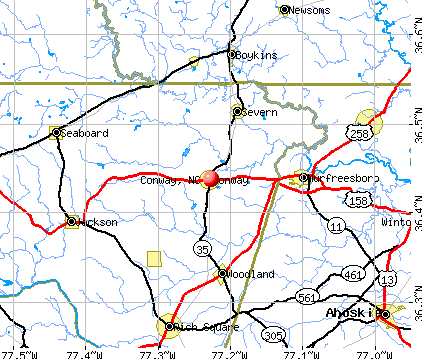
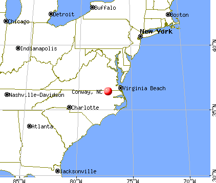
- OSM Map
- General Map
- Google Map
- MSN Map
Population change since 2000: -1.5%
| Males: 304 | |
| Females: 419 |
| Median resident age: | 31.1 years |
| North Carolina median age: | 39.2 years |
Zip codes: 27820.
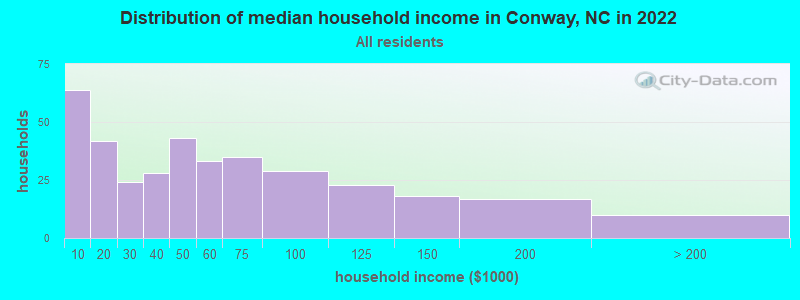
| Conway: | $43,938 |
| NC: | $67,481 |
Estimated per capita income in 2022: $22,835 (it was $14,969 in 2000)
Conway town income, earnings, and wages data
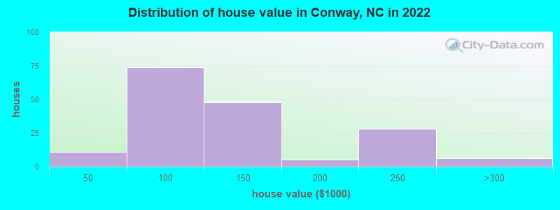
Estimated median house or condo value in 2022: $122,919 (it was $51,600 in 2000)
| Conway: | $122,919 |
| NC: | $280,600 |
Mean prices in 2022: all housing units: $136,076; detached houses: $141,458; mobile homes: $98,684
Median gross rent in 2022: $417.
(13.7% for White Non-Hispanic residents, 45.6% for Black residents, 20.7% for two or more races residents)
Detailed information about poverty and poor residents in Conway, NC
Compare current foreclosures near Conway, NC:
| Photo | Address | Area | Beds / Baths | Price | Details |
|---|---|---|---|---|---|

|
#1
Martin St
Conway, NC 27820
|
1,198 sq. feet
|
- baths 3 beds |
show details | |

|
#2
Phillips Hill Rd
Conway, NC 27820
|
1,848 sq. feet
|
- baths 3 beds |
show details | |

|
#3
Spring Branch Rd
Murfreesboro, NC 27855
|
1,300 sq. feet
|
1 baths 3 beds |
$132,500
|
show details |

|
#4
Hollowell Rd
Aulander, NC 27805
|
2,440 sq. feet
|
2 baths 4 beds |
show details | |

|
#5
Deloatche Ave
Boykins, VA 23827
|
2,424 sq. feet
|
3 baths 4 beds |
show details | |

|
#6
E Vance St
Murfreesboro, NC 27855
|
1,160 sq. feet
|
- baths - beds |
$12,900
|
show details |

|
#7
Hazel St
Woodland, NC 27897
|
- sq. feet
|
- baths - beds |
$23,900
|
show details |

|
#8
Clarksbury Rd
Boykins, VA 23827
|
1,735 sq. feet
|
2 baths 4 beds |
show details | |

|
#9
Raleigh St
Murfreesboro, NC 27855
|
2,398 sq. feet
|
3 baths 4 beds |
show details | |

|
#10
W Saluda Hall Rd
Ahoskie, NC 27910
|
1,488 sq. feet
|
2 baths 3 beds |
show details |
| Photo | Address | Area | Beds / Baths | Price | Details |
|---|---|---|---|---|---|

|
#11
Vinson Mill Rd
Murfreesboro, NC 27855
|
1,092 sq. feet
|
1 baths 3 beds |
show details | |

|
#12
Us Highway 258 N
Como, NC 27818
|
1,511 sq. feet
|
1 baths 3 beds |
show details | |

|
#13
Garfield Mitchell Rd
Ahoskie, NC 27910
|
1,120 sq. feet
|
1 baths 3 beds |
show details | |

|
#14
N West Rd
Murfreesboro, NC 27855
|
912 sq. feet
|
1 baths 2 beds |
show details | |

|
#15
Mckinley Dr W
Ahoskie, NC 27910
|
1,695 sq. feet
|
1 baths 3 beds |
show details | |

|
#16
Blue Foot Rd
Ahoskie, NC 27910
|
2,356 sq. feet
|
2 baths 4 beds |
show details | |

|
#17
Barrow Rd
Capron, VA 23829
|
864 sq. feet
|
1 baths 3 beds |
show details | |

|
#18
Vaughan Town Rd
Murfreesboro, NC 27855
|
864 sq. feet
|
2 baths 3 beds |
show details | |

|
#19
Church St W
Ahoskie, NC 27910
|
1,455 sq. feet
|
- baths 3 beds |
show details | |

|
#20
W Central St
Seaboard, NC 27876
|
1,292 sq. feet
|
- baths 3 beds |
show details |
| Photo | Address | Area | Beds / Baths | Price | Details |
|---|---|---|---|---|---|

|
#21
Academy St N
Ahoskie, NC 27910
|
1,260 sq. feet
|
- baths 3 beds |
show details | |

|
#22
Nc Highway 305
Rich Square, NC 27869
|
912 sq. feet
|
- baths 3 beds |
show details | |

|
#23
Cooke Cir
Rich Square, NC 27869
|
1,120 sq. feet
|
- baths 3 beds |
show details | |

|
#24
Abraham St
Jackson, NC 27845
|
1,036 sq. feet
|
- baths 4 beds |
show details | |

|
#25
Jane Ln
Pleasant Hill, NC 27866
|
2,052 sq. feet
|
- baths 4 beds |
show details | |

|
#26
Spruce St
Woodland, NC 27897
|
1,084 sq. feet
|
- baths 3 beds |
show details | |

|
#27
N 3rd St
Murfreesboro, NC 27855
|
616 sq. feet
|
2 baths - beds |
show details | |

|
#28
Deberry Mill Rd
Pendleton, NC 27862
|
1,248 sq. feet
|
- baths 3 beds |
show details | |

|
#29
Britton Rd
Pendleton, NC 27862
|
1,663 sq. feet
|
- baths 3 beds |
show details | |

|
#30
William Parker Rd
Murfreesboro, NC 27855
|
1,378 sq. feet
|
- baths 3 beds |
show details |
| Photo | Address | Area | Beds / Baths | Price | Details |
|---|---|---|---|---|---|

|
#31
Pine Tops Rd
Murfreesboro, NC 27855
|
- sq. feet
|
- baths - beds |
show details | |

|
#32
Millennium Rd
Aulander, NC 27805
|
- sq. feet
|
- baths - beds |
show details | |

|
#33
Bruce Farmer Rd
Aulander, NC 27805
|
- sq. feet
|
- baths - beds |
show details | |

|
#34
Sweet Betsy Ln
Ahoskie, NC 27910
|
- sq. feet
|
- baths - beds |
show details | |

|
#35
Harrell St
Murfreesboro, NC 27855
|
- sq. feet
|
- baths - beds |
show details | |

|
#36
Pecan Dr
Murfreesboro, NC 27855
|
- sq. feet
|
- baths - beds |
show details | |

|
#37
Gay Est
Jackson, NC 27845
|
- sq. feet
|
- baths - beds |
show details | |

|
#38
Church St W
Ahoskie, NC 27910
|
- sq. feet
|
- baths - beds |
show details | |

|
#39
Gay Est
Jackson, NC 27845
|
- sq. feet
|
- baths - beds |
show details | |

|
#40
West St N
Ahoskie, NC 27910
|
- sq. feet
|
- baths - beds |
show details |
| Photo | Address | Area | Beds / Baths | Price | Details |
|---|---|---|---|---|---|

|
#41
Colony Ave N
Ahoskie, NC 27910
|
- sq. feet
|
- baths - beds |
show details | |

|
#42
Lawrence St
Murfreesboro, NC 27855
|
- sq. feet
|
- baths - beds |
show details | |

|
#43
Pinetop Cir
Murfreesboro, NC 27855
|
- sq. feet
|
- baths - beds |
show details | |

|
#44
Pine Tops Rd
Murfreesboro, NC 27855
|
- sq. feet
|
- baths - beds |
show details | |

|
#45
Chapel Hill Church Rd
Rich Square, NC 27869
|
- sq. feet
|
- baths - beds |
show details | |

|
#46
Caroline St
Aulander, NC 27805
|
- sq. feet
|
- baths - beds |
show details | |

|
#47
E High St
Murfreesboro, NC 27855
|
- sq. feet
|
- baths - beds |
show details | |

|
#48
Nc Highway 305
Rich Square, NC 27869
|
- sq. feet
|
- baths - beds |
show details | |

|
#49
Purnell Ln
Jackson, NC 27845
|
- sq. feet
|
- baths - beds |
show details | |

|
Check over 1 million property listings on Foreclosure.com!
|
browse all offers | |||


- 39143.3%White alone
- 36340.2%Black alone
- 12413.7%Hispanic
- 101.1%Two or more races
- 60.7%Other race alone

Races in Conway detailed stats: ancestries, foreign born residents, place of birth
According to our research of North Carolina and other state lists, there were 9 registered sex offenders living in Conway, North Carolina as of April 27, 2024.
The ratio of all residents to sex offenders in Conway is 82 to 1.
Full-time law enforcement employees in 2021, including police officers: 2 (2 officers - 2 male; 0 female).
| Officers per 1,000 residents here: | 2.81 |
| North Carolina average: | 2.27 |
 Recent articles from our blog. Our writers, many of them Ph.D. graduates or candidates, create easy-to-read articles on a wide variety of topics.

 | East Raleigh Shooting Spree (315 replies) |
| What's The Real Deal On Crime in Charlotte in Late 2022??? (56 replies) |
| New CSA population data for Charlotte (26 replies) |
| The Official Triangle Random Thoughts Thread (5806 replies) |
| Family of four seeking NC relocation (154 replies) |
| Areas to live for young people (11 replies) |
Latest news from Conway, NC collected exclusively by city-data.com from local newspapers, TV, and radio stations
Ancestries: American (31.2%), English (12.1%), Irish (1.5%), French (1.2%).
Current Local Time: EST time zone
Elevation: 100 feet
Land area: 1.81 square miles.
Population density: 400 people per square mile (very low).
20 residents are foreign born (2.1% Latin America).
| This town: | 2.2% |
| North Carolina: | 8.3% |
Median real estate property taxes paid for housing units with mortgages in 2022: $1,011 (0.8%)
Median real estate property taxes paid for housing units with no mortgage in 2022: $1,299 (1.1%)
Nearest city with pop. 50,000+: Suffolk, VA  (40.2 miles , pop. 63,677).
Nearest city with pop. 200,000+: Norfolk, VA (62.0 miles , pop. 234,403).
Nearest city with pop. 1,000,000+: Philadelphia, PA (271.0 miles , pop. 1,517,550).
Nearest cities:
), ), Latitude: 36.44 N, Longitude: 77.23 W
Area code: 252
| Here: | 3.9% |
| North Carolina: | 3.2% |
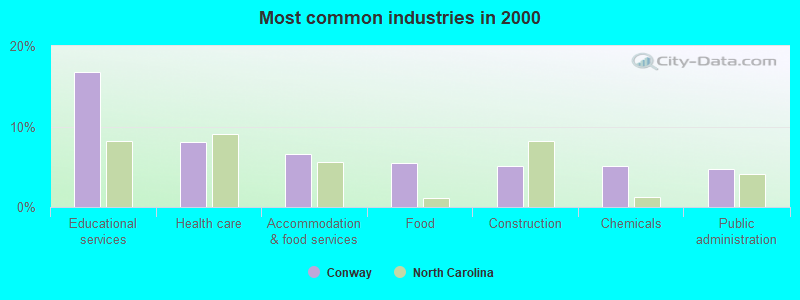
- Educational services (16.8%)
- Health care (8.0%)
- Accommodation & food services (6.6%)
- Food (5.5%)
- Construction (5.1%)
- Chemicals (5.1%)
- Public administration (4.7%)
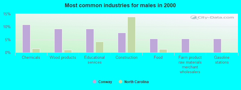
- Chemicals (10.8%)
- Wood products (9.2%)
- Educational services (9.2%)
- Construction (7.7%)
- Food (5.4%)
- Farm product raw materials merchant wholesalers (5.4%)
- Gasoline stations (5.4%)
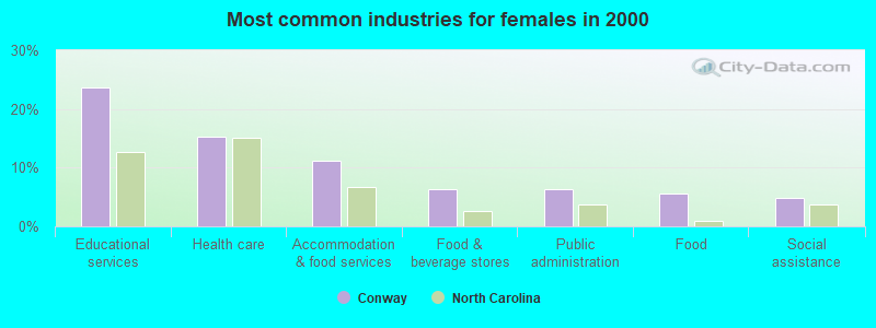
- Educational services (23.6%)
- Health care (15.3%)
- Accommodation & food services (11.1%)
- Food & beverage stores (6.2%)
- Public administration (6.2%)
- Food (5.6%)
- Social assistance (4.9%)
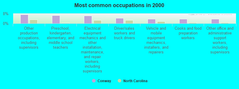
- Other production occupations, including supervisors (7.3%)
- Preschool, kindergarten, elementary, and middle school teachers (6.6%)
- Electrical equipment mechanics and other installation, maintenance, and repair workers, including supervisors (6.2%)
- Driver/sales workers and truck drivers (4.4%)
- Vehicle and mobile equipment mechanics, installers, and repairers (3.6%)
- Cooks and food preparation workers (3.6%)
- Other office and administrative support workers, including supervisors (3.6%)
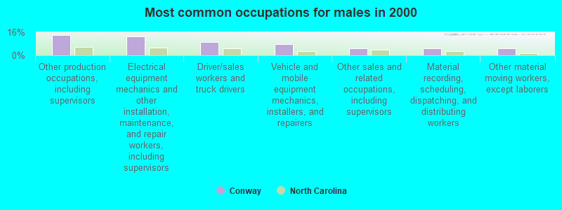
- Other production occupations, including supervisors (13.8%)
- Electrical equipment mechanics and other installation, maintenance, and repair workers, including supervisors (13.1%)
- Driver/sales workers and truck drivers (9.2%)
- Vehicle and mobile equipment mechanics, installers, and repairers (7.7%)
- Other sales and related occupations, including supervisors (4.6%)
- Material recording, scheduling, dispatching, and distributing workers (4.6%)
- Other material moving workers, except laborers (4.6%)
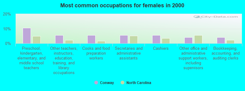
- Preschool, kindergarten, elementary, and middle school teachers (10.4%)
- Other teachers, instructors, education, training, and library occupations (5.6%)
- Cooks and food preparation workers (5.6%)
- Secretaries and administrative assistants (5.6%)
- Cashiers (5.6%)
- Other office and administrative support workers, including supervisors (4.2%)
- Bookkeeping, accounting, and auditing clerks (4.2%)
Average climate in Conway, North Carolina
Based on data reported by over 4,000 weather stations


(lower is better)
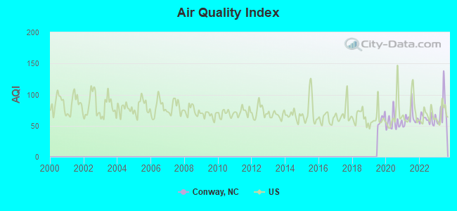
Air Quality Index (AQI) level in 2023 was 73.3. This is about average.
| City: | 73.3 |
| U.S.: | 72.6 |
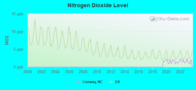
Nitrogen Dioxide (NO2) [ppb] level in 2023 was 1.38. This is significantly better than average. Closest monitor was 16.5 miles away from the city center.
| City: | 1.38 |
| U.S.: | 5.11 |
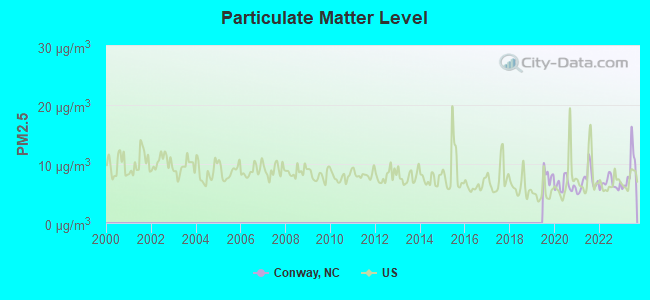
Particulate Matter (PM2.5) [µg/m3] level in 2023 was 8.95. This is about average. Closest monitor was 24.4 miles away from the city center.
| City: | 8.95 |
| U.S.: | 8.11 |
Tornado activity:
Conway-area historical tornado activity is slightly above North Carolina state average. It is 1% smaller than the overall U.S. average.
On 11/28/1988, a category F4 (max. wind speeds 207-260 mph) tornado 10.8 miles away from the Conway town center killed 4 people and injured 154 people and caused between $50,000,000 and $500,000,000 in damages.
On 3/28/1984, a category F3 (max. wind speeds 158-206 mph) tornado 17.9 miles away from the town center killed 6 people and injured 19 people and caused between $500,000 and $5,000,000 in damages.
Earthquake activity:
Conway-area historical earthquake activity is significantly above North Carolina state average. It is 58% smaller than the overall U.S. average.On 8/23/2011 at 17:51:04, a magnitude 5.8 (5.8 MW, Depth: 3.7 mi, Class: Moderate, Intensity: VI - VII) earthquake occurred 109.1 miles away from the city center
On 12/9/2003 at 20:59:14, a magnitude 4.5 (4.5 MB, 4.5 LG, Class: Light, Intensity: IV - V) earthquake occurred 87.8 miles away from the city center
On 8/9/2020 at 12:07:37, a magnitude 5.1 (5.1 MW, Depth: 4.7 mi) earthquake occurred 215.1 miles away from Conway center
On 12/9/2003 at 20:59:18, a magnitude 4.5 (4.5 ML, Depth: 6.2 mi) earthquake occurred 104.2 miles away from Conway center
On 8/25/2011 at 05:07:52, a magnitude 4.5 (4.5 ML, Depth: 4.2 mi) earthquake occurred 112.1 miles away from Conway center
On 8/24/2011 at 00:04:36, a magnitude 4.2 (4.2 ML) earthquake occurred 109.7 miles away from Conway center
Magnitude types: regional Lg-wave magnitude (LG), body-wave magnitude (MB), local magnitude (ML), moment magnitude (MW)
Natural disasters:
The number of natural disasters in Northampton County (17) is near the US average (15).Major Disasters (Presidential) Declared: 10
Emergencies Declared: 6
Causes of natural disasters: Hurricanes: 11, Storms: 2, Blizzard: 1, Flood: 1, Ice Storm: 1, Tornado: 1, Winter Storm: 1, Other: 1 (Note: some incidents may be assigned to more than one category).
Hospitals and medical centers in Conway:
Colleges/universities with over 2000 students nearest to Conway:
- Edgecombe Community College (about 44 miles; Tarboro, NC; Full-time enrollment: 2,058)
- Southside Virginia Community College (about 48 miles; Alberta, VA; FT enrollment: 3,716)
- Nash Community College (about 50 miles; Rocky Mount, NC; FT enrollment: 2,520)
- Virginia State University (about 57 miles; Petersburg, VA; FT enrollment: 5,815)
- Elizabeth City State University (about 58 miles; Elizabeth City, NC; FT enrollment: 2,803)
- East Carolina University (about 59 miles; Greenville, NC; FT enrollment: 23,943)
- Tidewater Community College (about 60 miles; Norfolk, VA; FT enrollment: 20,975)
Public high school in Conway:
- NORTHAMPTON COUNTY HIGH SCHOOL (Location: 750 NCHS ROAD, Grades: 9-12)
Public elementary/middle school in Conway:
- CONWAY MIDDLE (Location: 400 EAST MAIN STREET, Grades: 5-8)
Points of interest:
Notable location: Conway Police Department (A). Display/hide its location on the map
Tourist attraction: Georgia-Pacific Corporation LBR - Resin Plant (Cultural Attractions- Events- & Facilities; 200 Ampac Road).
Drinking water stations with addresses in Conway and their reported violations in the past:
CONWAY, TOWN OF (Population served: 711, Groundwater):Past monitoring violations:
- Monitoring and Reporting (DBP) - Between JAN-2012 and DEC-2012, Contaminant: Total Haloacetic Acids (HAA5). Follow-up actions: St Public Notif requested (MAR-08-2013), St Formal NOV issued (MAR-08-2013), St AO (w/o penalty) issued (MAR-08-2013), St AO (w/penalty) issued (APR-25-2013), St Public Notif received (JUN-25-2013), St Compliance achieved (JUL-24-2013)
- Monitoring and Reporting (DBP) - Between JAN-2012 and DEC-2012, Contaminant: TTHM. Follow-up actions: St Public Notif requested (MAR-08-2013), St Formal NOV issued (MAR-08-2013), St AO (w/o penalty) issued (MAR-08-2013), St AO (w/penalty) issued (APR-25-2013), St Public Notif received (JUN-25-2013), St Compliance achieved (JUL-24-2013)
- Monitoring, Routine (IDSE) - In APR-02-2008, Contaminant: DBP STAGE 2. Follow-up actions: St Compliance achieved (APR-02-2008)
| This town: | 2.3 people |
| North Carolina: | 2.5 people |
| This town: | 64.5% |
| Whole state: | 66.7% |
| This town: | 2.2% |
| Whole state: | 5.9% |
Likely homosexual households (counted as self-reported same-sex unmarried-partner households)
- Lesbian couples: 0.3% of all households
- Gay men: 0.0% of all households
Banks with branches in Conway (2011 data):
- First-Citizens Bank & Trust Company: Conway Branch at U.S. Highway 158, branch established on 1910/01/01. Info updated 2011/10/11: Bank assets: $20,566.4 mil, Deposits: $17,596.8 mil, headquarters in Raleigh, NC, positive income, Commercial Lending Specialization, 433 total offices, Holding Company: First Citizens Bancshares, Inc.
For population 15 years and over in Conway:
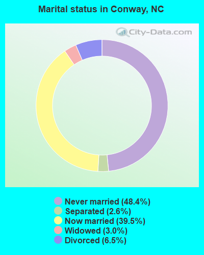
- Never married: 48.4%
- Now married: 39.5%
- Separated: 2.6%
- Widowed: 3.0%
- Divorced: 6.5%
For population 25 years and over in Conway:
- High school or higher: 86.5%
- Bachelor's degree or higher: 21.7%
- Graduate or professional degree: 10.6%
- Unemployed: 8.7%
- Mean travel time to work (commute): 24.2 minutes
| Here: | 11.1 |
| North Carolina average: | 11.7 |
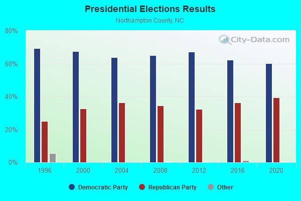
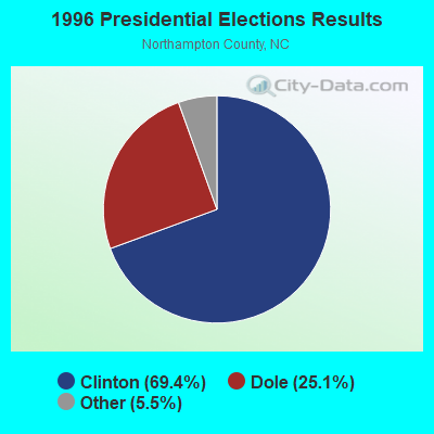
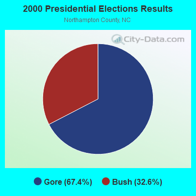

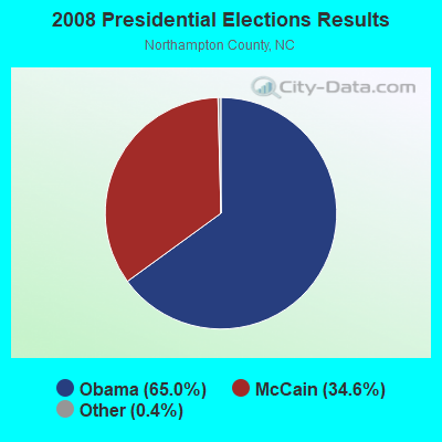
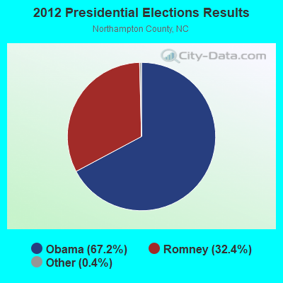
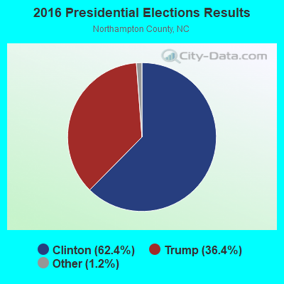
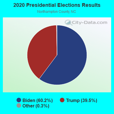
Graphs represent county-level data. Detailed 2008 Election Results
Religion statistics for Conway, NC (based on Northampton County data)
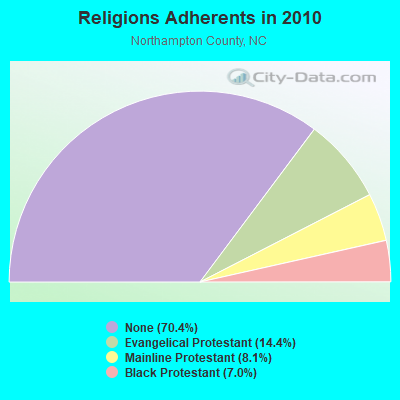
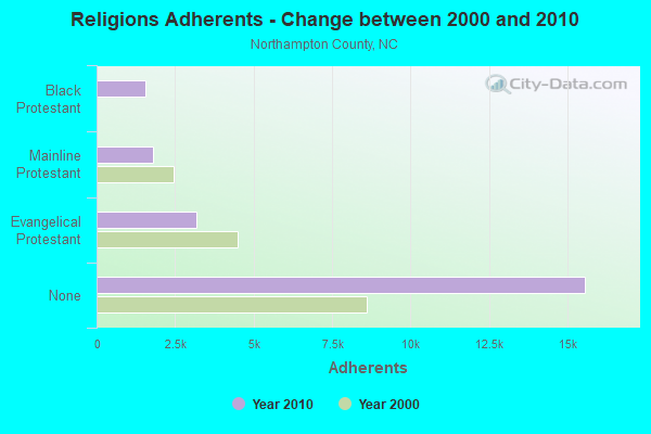
| Religion | Adherents | Congregations |
|---|---|---|
| Evangelical Protestant | 3,180 | 18 |
| Mainline Protestant | 1,796 | 17 |
| Black Protestant | 1,551 | 8 |
| Other | 4 | 2 |
| None | 15,568 | - |
Food Environment Statistics:
| Northampton County: | 3.37 / 10,000 pop. |
| North Carolina: | 2.05 / 10,000 pop. |
| Northampton County: | 1.45 / 10,000 pop. |
| North Carolina: | 0.92 / 10,000 pop. |
| Northampton County: | 4.82 / 10,000 pop. |
| North Carolina: | 4.75 / 10,000 pop. |
| Here: | 4.34 / 10,000 pop. |
| State: | 7.57 / 10,000 pop. |
| Northampton County: | 15.3% |
| North Carolina: | 9.8% |
| This county: | 37.5% |
| North Carolina: | 28.3% |
| Here: | 18.0% |
| North Carolina: | 15.6% |
Health and Nutrition:
| This city: | 45.6% |
| North Carolina: | 48.9% |
| Conway: | 38.8% |
| North Carolina: | 46.1% |
| This city: | 29.3 |
| North Carolina: | 28.8 |
| Conway: | 24.0% |
| State: | 20.7% |
| Here: | 13.8% |
| North Carolina: | 10.7% |
| Conway: | 6.8 |
| North Carolina: | 6.8 |
| Conway: | 35.5% |
| North Carolina: | 33.7% |
| Here: | 47.9% |
| North Carolina: | 55.8% |
| Here: | 75.3% |
| State: | 79.7% |
More about Health and Nutrition of Conway, NC Residents
| Local government employment and payroll (March 2022) | |||||
| Function | Full-time employees | Monthly full-time payroll | Average yearly full-time wage | Part-time employees | Monthly part-time payroll |
|---|---|---|---|---|---|
| Police Protection - Officers | 2 | $9,064 | $54,384 | 1 | $779 |
| Financial Administration | 1 | $4,285 | $51,420 | 0 | $0 |
| Water Supply | 1 | $4,165 | $49,980 | 1 | $1,694 |
| Other Government Administration | 1 | $3,316 | $39,792 | 0 | $0 |
| Sewerage | 1 | $5,630 | $67,560 | 0 | $0 |
| Totals for Government | 6 | $26,459 | $52,918 | 2 | $2,473 |
Conway government finances - Expenditure in 2017 (per resident):
- Current Operations - Water Utilities: $176,000 ($243.43)
Sewerage: $172,000 ($237.90)
Police Protection: $159,000 ($219.92)
Regular Highways: $158,000 ($218.53)
Financial Administration: $94,000 ($130.01)
Central Staff Services: $45,000 ($62.24)
Health - Other: $16,000 ($22.13)
Local Fire Protection: $13,000 ($17.98)
Natural Resources - Other: $11,000 ($15.21)
Parks and Recreation: $8,000 ($11.07)
Housing and Community Development: $1,000 ($1.38)
- General - Interest on Debt: $26,000 ($35.96)
Conway government finances - Revenue in 2017 (per resident):
- Charges - Sewerage: $143,000 ($197.79)
Miscellaneous Commercial Activities: $2,000 ($2.77)
- Miscellaneous - Rents: $4,000 ($5.53)
Donations From Private Sources: $1,000 ($1.38)
Interest Earnings: $0 ($0.00)
- Revenue - Water Utilities: $203,000 ($280.77)
- State Intergovernmental - General Local Government Support: $266,000 ($367.91)
Other: $27,000 ($37.34)
Highways: $24,000 ($33.20)
- Tax - Property: $253,000 ($349.93)
Conway government finances - Debt in 2017 (per resident):
- Long Term Debt - Beginning Outstanding - Unspecified Public Purpose: $640,000 ($885.20)
Outstanding Unspecified Public Purpose: $597,000 ($825.73)
Retired Unspecified Public Purpose: $43,000 ($59.47)
Businesses in Conway, NC
- U-Haul: 1
Strongest AM radio stations in Conway:
- WWDR (1080 AM; daytime; 1 kW; MURFREESBORO, NC; Owner: FIRST MEDIA RADIO, LLC)
- WTAR (850 AM; 50 kW; NORFOLK, VA; Owner: SINCLAIR COMMUNICATIONS)
- WCKO (1110 AM; daytime; 50 kW; NORFOLK, VA; Owner: WORD BROADCASTING NETWORK, INC.)
- WRVA (1140 AM; 50 kW; RICHMOND, VA; Owner: CLEAR CHANNEL BROADCASTING LICENSES, INC.)
- WRJR (670 AM; 20 kW; CLAREMONT, VA; Owner: CHESAPEAKE-PORTSMOUTH BROADCASTING CORPORATION)
- WPTF (680 AM; 50 kW; RALEIGH, NC; Owner: FIRST STATE COMMUNICATIONS)
- WYAL (1280 AM; daytime; 5 kW; SCOTLAND NECK, NC)
- WFTK (1030 AM; daytime; 50 kW; WAKE FOREST, NC; Owner: POSITIVE RADIO GROUP, INC.)
- WDZY (1290 AM; 25 kW; COLONIAL HEIGHTS, VA; Owner: ABC, INC.)
- WGH (1310 AM; 20 kW; NEWPORT NEWS, VA; Owner: CHESAPEAKE BAY BROADCASTING, LLC)
- WPMH (1010 AM; 10 kW; PORTSMOUTH, VA; Owner: ABC, INC.)
- WKGM (940 AM; 10 kW; SMITHFIELD, VA; Owner: WKGM, INC.)
- WNCT (1070 AM; 10 kW; GREENVILLE, NC; Owner: WNCT LICENSE LIMITED PARTNERSHIP)
Strongest FM radio stations in Conway:
- WDLZ (98.3 FM; MURFREESBORO, NC; Owner: FIRST MEDIA RADIO, LLC)
- WAFX (106.9 FM; SUFFOLK, VA; Owner: TIDEWATER COMMUNICATIONS, LLC)
- WTRG (100.7 FM; ROCKY MOUNT, NC; Owner: CAPSTAR TX LIMITED PARTNERSHIP)
- WZRU (88.5 FM; ROANOKE RAPIDS, NC; Owner: ROANOKE VALLEY COMMUNICATIONS, INC.)
- WYTT (97.9 FM; GASTON, NC; Owner: MAINQUAD, INC.)
- WBXB (100.1 FM; EDENTON, NC; Owner: EDENTON CHRISTIAN RADIO, INC.)
- WLQM-FM (101.7 FM; FRANKLIN, VA; Owner: FRANKLIN BROADCASTING CORPORATION)
- WRTP-FM (90.1 FM; ROANOKE RAPIDS, NC; Owner: RADIO TRAINING NETWORK, INC.)
- WCBZ (103.7 FM; WILLIAMSTON, NC; Owner: ABG NORTH CAROLINA, LLC)
- WKTC (95.5 FM; PINETOPS, NC; Owner: WEQQ, INC.)
- WHRO-FM (90.3 FM; NORFOLK, VA; Owner: HAMPTON ROADS EDUCATIONAL TELECOMMUNICATIONS ASSOCIATION,INC)
- WHRV (89.5 FM; NORFOLK, VA; Owner: HAMPTON ROADS EDUCATIONAL TELECOMMUNICATIONS ASSOCIATION,INC)
- WBKU (91.7 FM; AHSOKIE, NC; Owner: AMERICAN FAMILY ASSOCIATION)
- WKJX (96.7 FM; ELIZABETH CITY, NC; Owner: EAST CAROLINA RADIO OF ELIZABETH CITY, INC.)
- WQDK (99.3 FM; AHOSKIE, NC; Owner: MAX MEDIA OF THE CAROLINAS LLC)
- W214BJ (90.7 FM; MURFREESBORO, NC; Owner: CSN INTERNATIONAL)
TV broadcast stations around Conway:
- WUNP-TV (Channel 36; ROANOKE RAPIDS, NC; Owner: UNIVERSITY OF NORTH CAROLINA)
- WTVZ-TV (Channel 33; NORFOLK, VA; Owner: WTVZ LICENSEE, LLC)
- WHRO-TV (Channel 15; HAMPTON-NORFOLK, VA; Owner: HAMPTON ROADS EDUCATIONAL TELECOMMUNICATIONS ASSOC, INC.)
- WPXV (Channel 49; NORFOLK, VA; Owner: PAXSON COMMUNICATIONS LICENSE COMPANY, LLC)
- WNVN-LP (Channel 20; ROANOKE RAPIDS, NC; Owner: MAINQUAD COMMUNICATIONS, INC.)
Conway fatal accident list:
Oct 27, 1997 11:25 PM, Us158, Vehicles: 2, Persons: 2, Fatalities: 1, Drunk persons involved: 1
Sep 2, 1990 01:54 AM, 35, Vehicles: 1, Persons: 1, Fatalities: 1, Drunk persons involved: 1
- National Bridge Inventory (NBI) Statistics
- 4Number of bridges
- 43ft / 12.5mTotal length
- 2,940Total average daily traffic
- 193Total average daily truck traffic
- 5,880Total future (year 2040) average daily traffic
FCC Registered Cell Phone Towers:
1 (See the full list of FCC Registered Cell Phone Towers in Conway)FCC Registered Antenna Towers:
57 (See the full list of FCC Registered Antenna Towers)FCC Registered Broadcast Land Mobile Towers:
4- Church St (Lat: 36.439056 Lon: -77.227472), Type: Tower, Structure height: 18.3 m, Overall height: 25 m, Call Sign: WZM828,
Assigned Frequencies: 154.175 MHz, Grant Date: 10/27/2014, Expiration Date: 10/11/2024, Registrant: Federal License Management, 1784 E. 3rd Street Suite 269, Williamsport, PA 17701-3862, Phone: (866) 908-2220, Fax: (570) 322-6825, Email:
- Church St (Lat: 36.439056 Lon: -77.227472), Call Sign: KNEX290,
Assigned Frequencies: 155.280 MHz, Grant Date: 02/25/2003, Expiration Date: 02/26/2013, Cancellation Date: 05/04/2013, Registrant: Business Radio Licensing, 26941 Cabot Road 134, Laguna Hills, CA 92653, Phone: (949) 348-8510, Fax: (949) 348-8514, Email:
- Sr 1347 Tower Rd (Lat: 36.514306 Lon: -77.332472), Type: Tower, Structure height: 91 m, Overall height: 98 m, Call Sign: WPJV812,
Assigned Frequencies: 157.740 MHz, Grant Date: 09/11/2021, Expiration Date: 11/13/2031, Certifier: Donna P Burden, Registrant: Southeastern Cable Products Inc, Ahoskie, NC 27910, Phone: (252) 332-6764, Fax: (252) 209-0586, Email:
- Sr 1347 Tower Rd (Lat: 36.514583 Lon: -77.332194), Type: Tower, Structure height: 91 m, Overall height: 97 m, Call Sign: WPLR957,
Assigned Frequencies: 462.925 MHz, Grant Date: 12/16/2022, Expiration Date: 12/31/2032, Certifier: Donna P Burden, Registrant: Southeastern Cable Products Inc, Ahoskie, NC 27910, Phone: (252) 332-7900, Fax: (252) 209-0586, Email:
FCC Registered Microwave Towers:
3- CONWAY, .8 Mi W Of Int Of Sr 35 & Cr 1510 (Lat: 36.385556 Lon: -77.246111), Type: Gtower, Structure height: 91.4 m, Overall height: 96 m, Call Sign: WMW378,
Assigned Frequencies: 6226.89 MHz, 6137.92 MHz, Grant Date: 03/23/2021, Expiration Date: 02/01/2031, Certifier: Steven T Campbell, Registrant: Wilkinson Barker Knauer, LLP, 1800 M Street Nw, Suite 800n, Washington, DC 20036, Phone: (202) 383-3420, Fax: (202) 783-5851, Email:
- HP-1362, Old Mill, Buck Boone Road (Lat: 36.405028 Lon: -77.228917), Type: Tower, Structure height: 150.9 m, Call Sign: WQMY633,
Assigned Frequencies: 6605.00 MHz, Grant Date: 09/08/2020, Expiration Date: 11/09/2030, Certifier: Wayne E Eberhard, Registrant: North Carolina State Highway Patrol, 4231 Mail Service Center, Raleigh, NC 26799-4231, Phone: (919) 662-4440, Fax: (919) 662-4444, Email:
- OLD MILL, Hp-1362, Old Mill, Buck Boone Road (Lat: 36.405028 Lon: -77.228917), Type: Ltower, Structure height: 150.9 m, Call Sign: WQOG431,
Assigned Frequencies: 6034.15 MHz, 933.775 MHz, 942.775 MHz, Grant Date: 08/10/2021, Expiration Date: 09/19/2031, Certifier: Ronald P Storey Jr, Registrant: Radio Communications Company, Cary, NC 27512, Phone: (919) 467-2421, Fax: (919) 467-6548, Email:
FCC Registered Amateur Radio Licenses:
7- Call Sign: K4ERT, Previous Call Sign: N4KKP, Licensee ID: L00208813, Grant Date: 04/04/2006, Expiration Date: 06/29/2016, Cancellation Date: 06/30/2018, Registrant: Linwood E Ward, W Main St, Conway, NC 27820
- Call Sign: KD4HRL, Licensee ID: L00781218, Grant Date: 01/17/2024, Expiration Date: 01/18/2034, Registrant: Michael D Hasty, 115 Elizabeth St., Conway, NC 27820
- Call Sign: KI4DTX, Licensee ID: L00803657, Grant Date: 01/18/2024, Expiration Date: 01/26/2034, Certifier: Stacy K Futrell, Registrant: Stacy K Futrell, 164 Ruby Vick Rd, Conway, NC 27820
- Call Sign: KK4ARX, Licensee ID: L01623012, Grant Date: 01/23/2021, Expiration Date: 03/08/2031, Certifier: Robert L Bridgers Jr, Registrant: Robert L Bridgers Jr, 407 S Church St, Conway, NC 27820
- Call Sign: KK4ARY, Licensee ID: L01622567, Grant Date: 03/08/2011, Expiration Date: 03/08/2021, Cancellation Date: 05/14/2011, Certifier: Bobbi S Piland, Registrant: Bobbi S Piland, 2426 Deberrys Mill Road, Conway, NC 27820
- Call Sign: K4ARY, Previous Call Sign: KK4ARY, Licensee ID: L01622567, Grant Date: 03/01/2021, Expiration Date: 05/14/2031, Certifier: Bobbi Piland, Registrant: Bobbi Piland, 2426 Deberrys Mill Road, Conway, NC 27820
- Call Sign: KK4REV, Licensee ID: L01787913, Grant Date: 03/08/2023, Expiration Date: 05/16/2033, Certifier: Timothy L Guest, Registrant: Timothy L Guest, 12188 Us Hwy 158, Conway, NC 27820
2002 - 2018 National Fire Incident Reporting System (NFIRS) incidents
- Fire incident types reported to NFIRS in Conway, NC
- 13648.4%Structure Fires
- 8731.0%Outside Fires
- 4917.4%Mobile Property/Vehicle Fires
- 93.2%Other
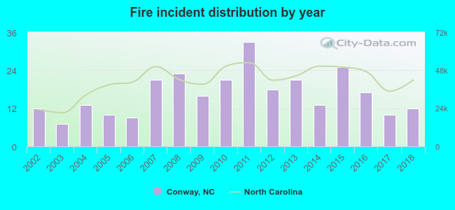 Based on the data from the years 2002 - 2018 the average number of fire incidents per year is 17. The highest number of reported fires - 33 took place in 2011, and the least - 7 in 2003. The data has a constant trend.
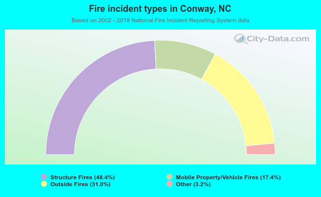 When looking into fire subcategories, the most incidents belonged to: Structure Fires (48.4%), and Outside Fires (31.0%).
| Most common first names in Conway, NC among deceased individuals | ||
| Name | Count | Lived (average) |
|---|---|---|
| James | 31 | 72.2 years |
| Mary | 25 | 77.1 years |
| William | 25 | 71.9 years |
| John | 22 | 74.0 years |
| Willie | 19 | 72.8 years |
| Robert | 14 | 67.5 years |
| Annie | 14 | 76.0 years |
| Walter | 13 | 77.9 years |
| Joseph | 13 | 70.4 years |
| Charlie | 11 | 76.4 years |
| Most common last names in Conway, NC among deceased individuals | ||
| Last name | Count | Lived (average) |
|---|---|---|
| Davis | 51 | 74.0 years |
| Lassiter | 50 | 76.5 years |
| Deloatch | 49 | 70.1 years |
| Martin | 39 | 78.4 years |
| Bridgers | 35 | 79.9 years |
| Futrell | 34 | 80.0 years |
| Flythe | 27 | 72.0 years |
| Vann | 25 | 76.6 years |
| Johnson | 21 | 78.9 years |
| Joyner | 18 | 69.6 years |
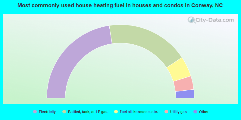
- 45.5%Electricity
- 36.5%Bottled, tank, or LP gas
- 9.0%Fuel oil, kerosene, etc.
- 6.0%Utility gas
- 2.0%No fuel used
- 1.0%Other fuel
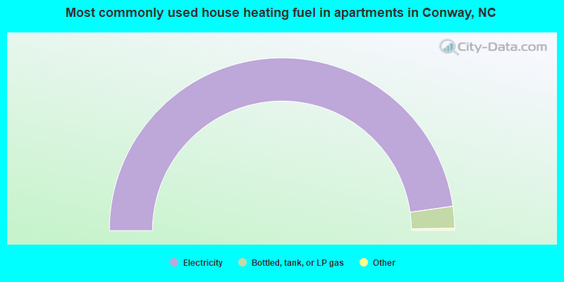
- 95.9%Electricity
- 4.1%Bottled, tank, or LP gas
Conway compared to North Carolina state average:
- Median household income below state average.
- Median house value significantly below state average.
- Black race population percentage above state average.
- Median age below state average.
- Foreign-born population percentage significantly below state average.
- Length of stay since moving in significantly above state average.
- House age above state average.
Conway on our top lists:
- #97 on the list of "Top 100 cities with the largest percentage of females"
- #85 on the list of "Top 101 counties with the smallest number of children under 18 without health insurance coverage in 2000"

|
Total of 5 patent applications in 2008-2024.