Cooperstown, Wisconsin
Submit your own pictures of this town and show them to the world
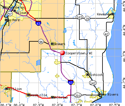
- OSM Map
- General Map
- Google Map
- MSN Map
Population change since 2000: -7.9%
 |
| Males: 675 | |
| Females: 617 |
| Median resident age: | 44.9 years |
| Wisconsin median age: | 42.6 years |
Zip codes: 54227.
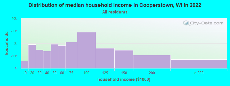
| Cooperstown: | $82,889 |
| WI: | $70,996 |
Estimated per capita income in 2022: $35,027 (it was $20,941 in 2000)
Cooperstown town income, earnings, and wages data
Estimated median house or condo value in 2022: $241,574 (it was $132,800 in 2000)
| Cooperstown: | $241,574 |
| WI: | $252,800 |
Mean prices in 2022: all housing units: $213,664; detached houses: $222,777; townhouses or other attached units: $189,612; in 2-unit structures: $121,476; in 3-to-4-unit structures: $125,936; in 5-or-more-unit structures: $113,942; mobile homes: $52,862
Detailed information about poverty and poor residents in Cooperstown, WI


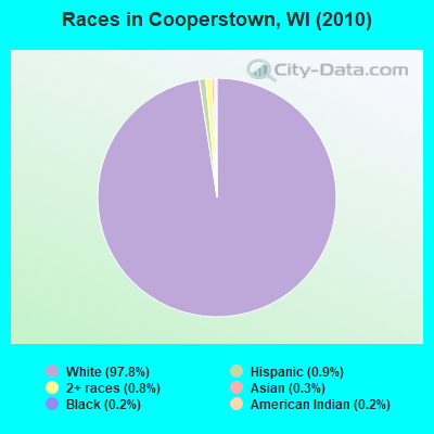
- 1,26397.8%White alone
- 110.9%Hispanic
- 100.8%Two or more races
- 40.3%Asian alone
- 20.2%Black alone
- 20.2%American Indian alone
Races in Cooperstown detailed stats: ancestries, foreign born residents, place of birth
 Recent articles from our blog. Our writers, many of them Ph.D. graduates or candidates, create easy-to-read articles on a wide variety of topics.

Latest news from Cooperstown, WI collected exclusively by city-data.com from local newspapers, TV, and radio stations
Ancestries: German (55.6%), Czech (15.8%), Irish (12.1%), Polish (11.9%), Danish (5.7%), Dutch (5.1%).
Current Local Time: CST time zone
Elevation: 782 feet
Land area: 35.1 square miles.
Population density: 37 people per square mile (very low).
24 residents are foreign born
| This town: | 1.7% |
| Wisconsin: | 3.6% |
| Cooperstown town: | 1.3% ($1,763) |
| Wisconsin: | 2.0% ($2,245) |
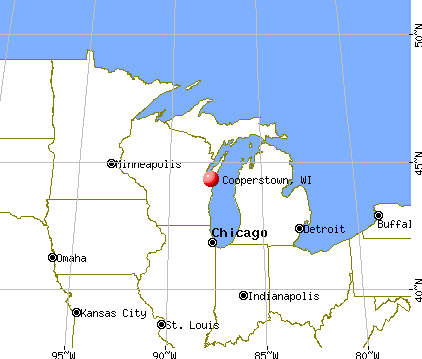
Nearest city with pop. 50,000+: Green Bay, WI  (18.6 miles , pop. 102,313).
Nearest city with pop. 200,000+: Milwaukee, WI (85.5 miles , pop. 596,974).
Nearest city with pop. 1,000,000+: Chicago, IL (169.1 miles , pop. 2,896,016).
Nearest cities:
), ), ), ), ), )Latitude: 44.28 N, Longitude: 87.82 W
Area code commonly used in this area: 920

| Here: | 2.6% |
| Wisconsin: | 2.7% |
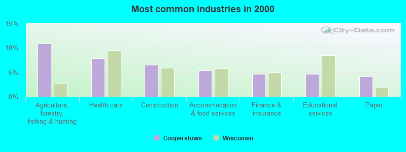
- Agriculture, forestry, fishing & hunting (10.8%)
- Health care (7.9%)
- Construction (6.5%)
- Accommodation & food services (5.4%)
- Finance & insurance (4.7%)
- Educational services (4.7%)
- Paper (4.2%)
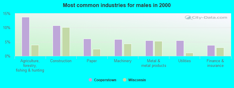
- Agriculture, forestry, fishing & hunting (13.7%)
- Construction (10.8%)
- Paper (6.1%)
- Machinery (5.9%)
- Metal & metal products (5.5%)
- Utilities (5.5%)
- Finance & insurance (3.8%)

- Health care (15.9%)
- Accommodation & food services (10.9%)
- Educational services (8.5%)
- Agriculture, forestry, fishing & hunting (6.8%)
- Finance & insurance (5.9%)
- Department & other general merchandise stores (5.6%)
- Professional, scientific, technical services (5.0%)
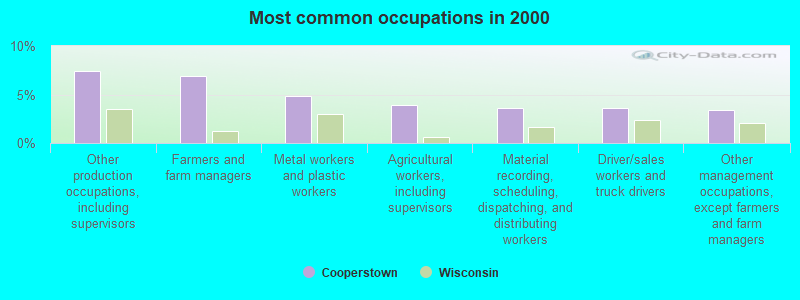
- Other production occupations, including supervisors (7.4%)
- Farmers and farm managers (6.9%)
- Metal workers and plastic workers (4.8%)
- Agricultural workers, including supervisors (3.9%)
- Material recording, scheduling, dispatching, and distributing workers (3.6%)
- Driver/sales workers and truck drivers (3.6%)
- Other management occupations, except farmers and farm managers (3.4%)
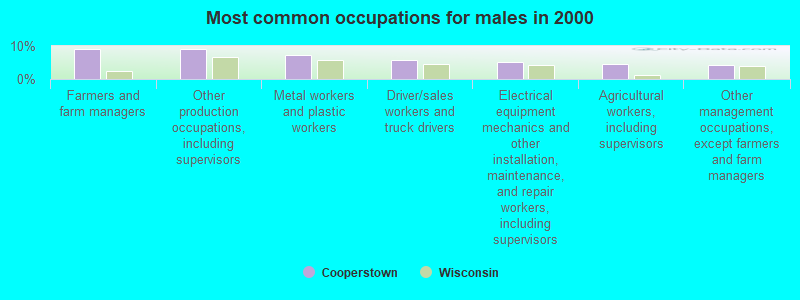
- Farmers and farm managers (9.1%)
- Other production occupations, including supervisors (9.1%)
- Metal workers and plastic workers (7.4%)
- Driver/sales workers and truck drivers (5.7%)
- Electrical equipment mechanics and other installation, maintenance, and repair workers, including supervisors (5.1%)
- Agricultural workers, including supervisors (4.4%)
- Other management occupations, except farmers and farm managers (4.2%)
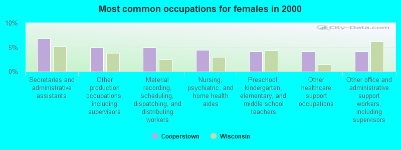
- Secretaries and administrative assistants (6.8%)
- Other production occupations, including supervisors (5.0%)
- Material recording, scheduling, dispatching, and distributing workers (5.0%)
- Nursing, psychiatric, and home health aides (4.4%)
- Preschool, kindergarten, elementary, and middle school teachers (4.1%)
- Other healthcare support occupations (4.1%)
- Other office and administrative support workers, including supervisors (4.1%)
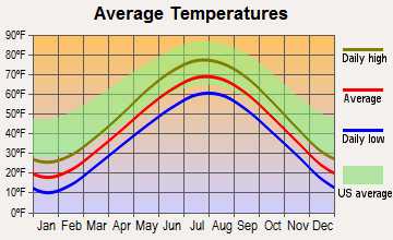
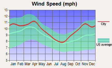
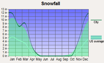
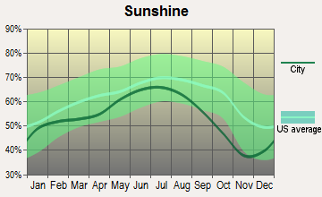
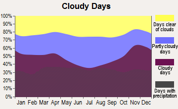
Average climate in Cooperstown, Wisconsin
Based on data reported by over 4,000 weather stations
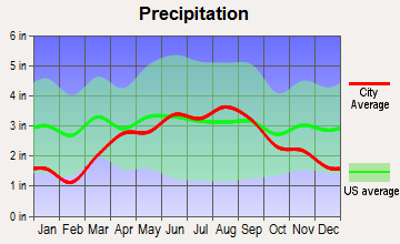
(lower is better)
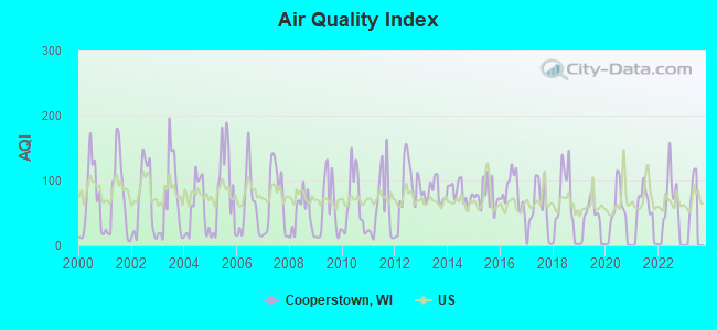
Air Quality Index (AQI) level in 2022 was 53.5. This is better than average.
| City: | 53.5 |
| U.S.: | 72.6 |
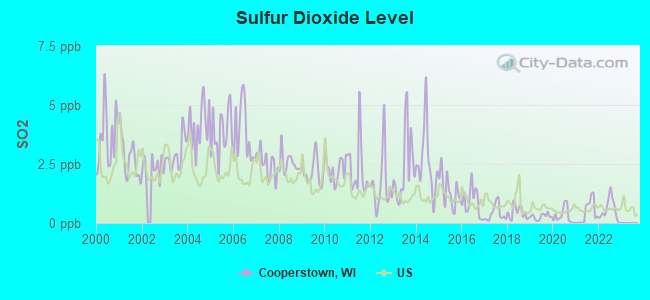
Sulfur Dioxide (SO2) [ppb] level in 2022 was 0.556. This is significantly better than average. Closest monitor was 16.5 miles away from the city center.
| City: | 0.556 |
| U.S.: | 1.515 |
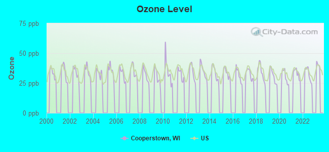
Ozone [ppb] level in 2022 was 32.4. This is about average. Closest monitor was 14.1 miles away from the city center.
| City: | 32.4 |
| U.S.: | 33.3 |
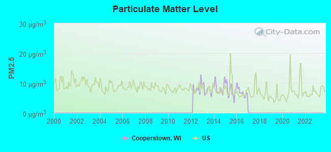
Particulate Matter (PM2.5) [µg/m3] level in 2016 was 6.90. This is about average. Closest monitor was 14.2 miles away from the city center.
| City: | 6.90 |
| U.S.: | 8.11 |
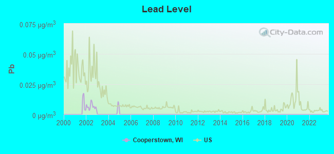
Lead (Pb) [µg/m3] level in 2002 was 0.00649. This is significantly better than average. Closest monitor was 15.4 miles away from the city center.
| City: | 0.00649 |
| U.S.: | 0.00931 |
Tornado activity:
Cooperstown-area historical tornado activity is slightly below Wisconsin state average. It is 10% smaller than the overall U.S. average.
On 7/5/1994, a category F4 (max. wind speeds 207-260 mph) tornado 0.3 miles away from the Cooperstown town center injured 2 people and caused between $500,000 and $5,000,000 in damages.
On 4/27/1984, a category F4 tornado 26.4 miles away from the town center killed one person and injured 19 people and caused between $500,000 and $5,000,000 in damages.
Earthquake activity:
Cooperstown-area historical earthquake activity is significantly above Wisconsin state average. It is 22% smaller than the overall U.S. average.On 5/2/2015 at 16:23:07, a magnitude 4.2 (4.2 MW, Depth: 2.8 mi, Class: Light, Intensity: IV - V) earthquake occurred 185.9 miles away from the city center
On 4/18/2008 at 09:36:59, a magnitude 5.4 (5.1 MB, 4.8 MS, 5.4 MW, 5.2 MW, Class: Moderate, Intensity: VI - VII) earthquake occurred 403.4 miles away from Cooperstown center
On 6/28/2004 at 06:10:52, a magnitude 4.2 (4.2 MW, Depth: 6.2 mi) earthquake occurred 202.8 miles away from the city center
On 6/10/1987 at 23:48:54, a magnitude 5.1 (4.9 MB, 4.4 MS, 4.6 MS, 5.1 LG) earthquake occurred 377.9 miles away from the city center
On 4/18/2008 at 09:36:59, a magnitude 5.2 (5.2 MW, Depth: 8.9 mi) earthquake occurred 403.4 miles away from the city center
On 2/10/2010 at 09:59:35, a magnitude 3.8 (3.8 MW, Depth: 6.2 mi, Class: Light, Intensity: II - III) earthquake occurred 163.7 miles away from the city center
Magnitude types: regional Lg-wave magnitude (LG), body-wave magnitude (MB), surface-wave magnitude (MS), moment magnitude (MW)
Natural disasters:
The number of natural disasters in Manitowoc County (7) is smaller than the US average (15).Major Disasters (Presidential) Declared: 5
Emergencies Declared: 2
Causes of natural disasters: Floods: 4, Storms: 4, Tornadoes: 2, Hurricane: 1, Wind: 1, Winter Storm: 1, Other: 1 (Note: some incidents may be assigned to more than one category).

Hospitals and medical centers near Cooperstown:
- LEDGE VIEW NURSING CENTER (Nursing Home, about 9 miles away; DE PERE, WI)
- RIVERS BEND HLTH REHAB (Nursing Home, about 14 miles away; MANITOWOC, WI)
- UNITY HOSPICE (Hospital, about 15 miles away; DE PERE, WI)
- INTERIM HLTHCARE OF NE WI (Home Health Center, about 15 miles away; GREEN BAY, WI)
- KINDRED NURSING AND REHABILITATION-NORTH RIDGE (Nursing Home, about 15 miles away; MANITOWOC, WI)
- NORTH RIDGE CARE CENTER (Nursing Home, about 15 miles away; MANITOWOC, WI)
- AURORA BAYCARE MED CTR Acute Care Hospitals (about 15 miles away; GREEN BAY, WI)
Operable nuclear power plants near Cooperstown:
- 14 miles: Kewaunee in Carlton, WI.
- 15 miles: Point Beach 1 and 2 in Two Rivers, WI.
Colleges/universities with over 2000 students nearest to Cooperstown:
- Saint Norbert College (about 17 miles; De Pere, WI; Full-time enrollment: 2,324)
- University of Wisconsin-Green Bay (about 18 miles; Green Bay, WI; FT enrollment: 5,415)
- Northeast Wisconsin Technical College (about 22 miles; Green Bay, WI; FT enrollment: 6,069)
- Lawrence University (about 29 miles; Appleton, WI; FT enrollment: 2,821)
- Lakeland College (about 31 miles; Plymouth, WI; FT enrollment: 2,395)
- Fox Valley Technical College (about 32 miles; Appleton, WI; FT enrollment: 5,682)
- University of Wisconsin-Oshkosh (about 41 miles; Oshkosh, WI; FT enrollment: 10,637)
Points of interest:
Notable locations in Cooperstown: Pelishek Corners (A), Am-En Dairy (B), Greenstreet (C), Maribel Fire Department (D). Display/hide their locations on the map
Churches in Cooperstown include: Saint James Catholic Church (A), Saint Johns Lutheran Church (B), Saint Marys Church (C). Display/hide their locations on the map
Cemeteries: Denmark Cemetery (1), Saint James Catholic Cemetery (2), Saint Johns Lutheran Cemetery (3), Lark Emmanuel Cemetery (4). Display/hide their locations on the map
Lakes and swamps: Hidden Lake (A), Cooperstown Swamp (B). Display/hide their locations on the map
Rivers: Neshota River (A), Devils River (B). Display/hide their locations on the map
Park in Cooperstown: Cherney Maribel Caves State Natural Area (1). Display/hide its location on the map
| This town: | 2.6 people |
| Wisconsin: | 2.4 people |
| This town: | 77.5% |
| Whole state: | 64.4% |
| This town: | 6.2% |
| Whole state: | 7.3% |
No gay or lesbian households reported
| This town: | 3.8% |
| Whole state: | 8.7% |
| This town: | 3.0% |
| Whole state: | 3.7% |
For population 15 years and over in Cooperstown:
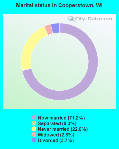
- Never married: 22.0%
- Now married: 71.2%
- Separated: 0.3%
- Widowed: 2.8%
- Divorced: 3.7%
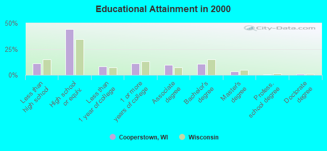
For population 25 years and over in Cooperstown:
- High school or higher: 89.0%
- Bachelor's degree or higher: 15.4%
- Graduate or professional degree: 4.8%
- Unemployed: 2.4%
- Mean travel time to work (commute): 23.9 minutes
| Here: | 9.0 |
| Wisconsin average: | 11.0 |
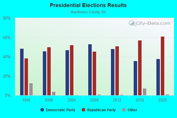

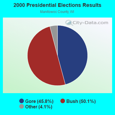
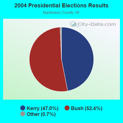
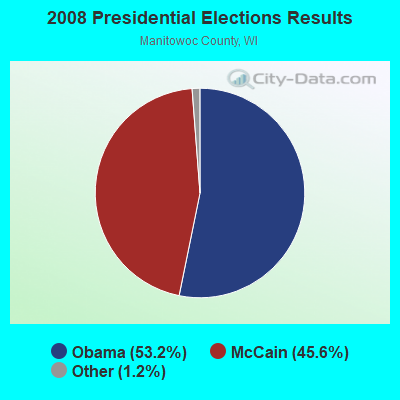
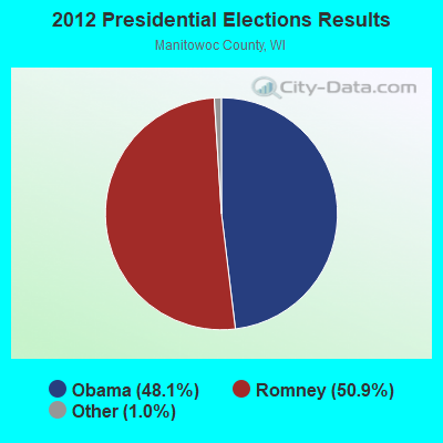
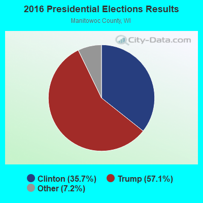
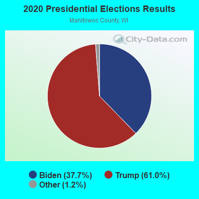
Graphs represent county-level data. Detailed 2008 Election Results
Religion statistics for Cooperstown, WI (based on Manitowoc County data)
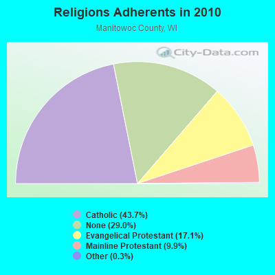
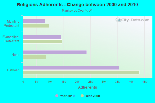
| Religion | Adherents | Congregations |
|---|---|---|
| Catholic | 35,564 | 14 |
| Evangelical Protestant | 13,965 | 42 |
| Mainline Protestant | 8,051 | 21 |
| Other | 259 | 4 |
| None | 23,603 | - |
Food Environment Statistics:
| Manitowoc County: | 1.24 / 10,000 pop. |
| Wisconsin: | 1.86 / 10,000 pop. |
| Manitowoc County: | 0.12 / 10,000 pop. |
| Wisconsin: | 0.11 / 10,000 pop. |
| Here: | 0.12 / 10,000 pop. |
| Wisconsin: | 0.38 / 10,000 pop. |
| Manitowoc County: | 4.09 / 10,000 pop. |
| State: | 4.12 / 10,000 pop. |
| Manitowoc County: | 8.05 / 10,000 pop. |
| State: | 8.64 / 10,000 pop. |
| This county: | 7.8% |
| Wisconsin: | 7.6% |
| This county: | 29.2% |
| Wisconsin: | 27.5% |
| Manitowoc County: | 14.8% |
| State: | 13.0% |
Strongest AM radio stations in Cooperstown:
- WNAM (1280 AM; 50 kW; NEENAH-MENASHA, WI; Owner: CUMULUS LICENSING CORP.)
- WTAQ (1360 AM; 10 kW; GREEN BAY, WI; Owner: MIDWEST COMMUNICATIONS, INC.)
- WCUB (980 AM; 5 kW; TWO RIVERS, WI; Owner: CUB RADIO, INC.)
- WHBY (1150 AM; 25 kW; KIMBERLY, WI; Owner: WOODWARD COMMUNICATIONS, INC.)
- WNFL (1440 AM; 5 kW; GREEN BAY, WI; Owner: MIDWEST COMMUNICATIONS, INC.)
- WTMJ (620 AM; 50 kW; MILWAUKEE, WI; Owner: JOURNAL BROADCAST CORPORATION)
- WSPT (1010 AM; 50 kW; STEVENS POINT, WI)
- WTCM (580 AM; 35 kW; TRAVERSE CITY, MI; Owner: WTCM RADIO, INC.)
- WISN (1130 AM; 50 kW; MILWAUKEE, WI; Owner: CAPSTAR TX LIMITED PARTNERSHIP)
- WOMT (1240 AM; 1 kW; MANITOWOC, WI; Owner: SEEHAFER BROADCASTING CORP)
- WSAU (550 AM; 20 kW; WAUSAU, WI; Owner: WRIG, INC.)
- WLDR (1210 AM; daytime; 50 kW; KINGSLEY, MI; Owner: FORT BEND BROADCASTING COMPANY)
- WTRW (1590 AM; 1 kW; TWO RIVERS, WI; Owner: WTRW, INC.)
Strongest FM radio stations in Cooperstown:
- WHID (88.1 FM; GREEN BAY, WI; Owner: BD OF REGENTS OF THE UNIV OF WI SYS)
- WXWX (107.5 FM; BRILLION, WI; Owner: CUMULUS LICENSING CORP.)
- WIXX (101.1 FM; GREEN BAY, WI; Owner: MIDWEST COMMUNICATIONS, INC.)
- WOGB (103.1 FM; KAUKAUNA, WI; Owner: CUMULUS LICENSING CORP.)
- WPNE-FM (89.3 FM; GREEN BAY, WI; Owner: WISCONSIN EDUCATIONAL COMMUNICATIONS BOARD)
- WORQ (90.1 FM; GREEN BAY, WI; Owner: LAKESHORE COMMUNICATIONS, INC.)
- WKSZ (95.9 FM; DE PERE, WI; Owner: WOODWARD COMMUNICATIONS INC)
- WZOR (94.7 FM; MISHICOT, WI; Owner: WOODWARD COMMUNICATIONS, INC.)
- WEMY (91.5 FM; GREEN BAY, WI; Owner: EVANGEL MINISTRIES, INC)
- WAPL-FM (105.7 FM; APPLETON, WI; Owner: WOODWARD COMMUNICATIONS, INC.)
- WJLW (106.7 FM; ALLOUEZ, WI; Owner: CUMULUS LICENSING CORP)
- WLTU (92.1 FM; MANITOWOC, WI; Owner: CUB RADIO, INC.)
- W270AJ (101.9 FM; GREEN BAY, WI; Owner: MIDWEST COMMUNICATIONS, INC)
- WPCK (104.9 FM; KAUKAUNA, WI; Owner: MIDWEST DIMENSIONS, INC.)
- W215BF (90.9 FM; MANITOWOC, WI; Owner: CALVARY CHAPEL OF TWIN FALLS, INC.)
- WQTC-FM (102.3 FM; MANITOWOC, WI; Owner: SEEHAFER BROADCASTING CORPORATION)
- WLYD (99.7 FM; STURGEON BAY, WI; Owner: MIDWEST COMMUNICATIONS INC)
- WAUN-FM (92.7 FM; KEWAUNEE, WI; Owner: MAGNUM BROADCASTING, INC.)
- WBDK (96.7 FM; ALGOMA, WI; Owner: NICOLET BROADCASTING, INC.)
- WLKN (98.1 FM; CLEVELAND, WI; Owner: RADIO K-T, INC.)
TV broadcast stations around Cooperstown:
- WLUK-TV (Channel 11; GREEN BAY, WI; Owner: EMMIS TELEVISION LICENSE CORPORATION)
- WFRV-TV (Channel 5; GREEN BAY, WI; Owner: CBS BROADCASTING INC.)
- WGBA (Channel 26; GREEN BAY, WI; Owner: ARIES TELECOMMUNICATION CORPORATION)
- WBAY-TV (Channel 2; GREEN BAY, WI; Owner: YOUNG BROADCASTING OF GREEN BAY, INC.)
- WACY (Channel 32; APPLETON, WI; Owner: ACE TV, INC.)
- WPNE (Channel 38; GREEN BAY, WI; Owner: WISCONSIN EDUCATIONAL COMMUNICATIONS BOARD)
- W30BU (Channel 30; GREEN BAY, WI; Owner: THREE ANGELS BROADCASTING NETWORK)
- W49CB (Channel 49; GREEN BAY, WI; Owner: TRINITY BROADCASTING NETWORK)
- WMMF-TV (Channel 68; FOND DU LAC, WI; Owner: PAPPAS TELECASTING OF WISCONSIN, A CALIFORNIA LTD PARTNRSHP)
- WIWB (Channel 14; SURING, WI; Owner: ACME TV LICENSES OF WISCONSIN, LLC)
- National Bridge Inventory (NBI) Statistics
- 43Number of bridges
- 410ft / 125mTotal length
- $2,313,000Total costs
- 226,183Total average daily traffic
- 38,705Total average daily truck traffic
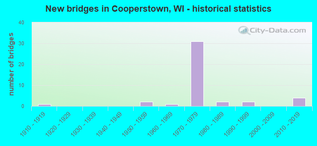
- New bridges - historical statistics
- 11910-1919
- 21950-1959
- 11960-1969
- 311970-1979
- 21980-1989
- 21990-1999
- 42010-2019
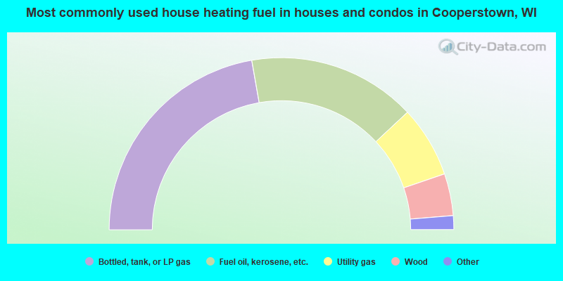
- 44.5%Bottled, tank, or LP gas
- 31.6%Fuel oil, kerosene, etc.
- 13.4%Utility gas
- 7.9%Wood
- 2.0%Electricity
- 0.4%Other fuel
- 0.2%Solar energy
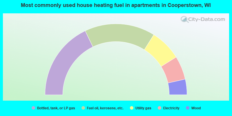
- 35.7%Bottled, tank, or LP gas
- 32.1%Fuel oil, kerosene, etc.
- 14.3%Utility gas
- 10.7%Electricity
- 7.1%Wood
Cooperstown compared to Wisconsin state average:
- Unemployed percentage significantly below state average.
- Black race population percentage significantly below state average.
- Hispanic race population percentage significantly below state average.
- Foreign-born population percentage significantly below state average.
- Renting percentage significantly below state average.
- Length of stay since moving in significantly above state average.
- Number of rooms per house significantly below state average.
- House age significantly below state average.