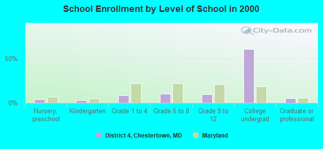
District 4, Chestertown, Maryland
Submit your own pictures of this city and show them to the world
- OSM Map
- General Map
- Google Map
- MSN Map

| Males: 2,346 | |
| Females: 3,035 |
| Median resident age: | 37.8 years |
| Maryland median age: | 36.0 years |
Zip code: 21620
| District 4, Chestertown: | $58,048 |
| MD: | $94,991 |
Estimated per capita income in 2022: $39,768 (it was $19,621 in 2000)
District 4, Chestertown income, earnings, and wages data
Estimated median house or condo value in 2022: $355,881 (it was $141,000 in 2000)
| District 4, Chestertown: | $355,881 |
| MD: | $398,100 |
District 4, Chestertown, MD residents, houses, and apartments details
Detailed information about poverty and poor residents in District 4, Chestertown, MD


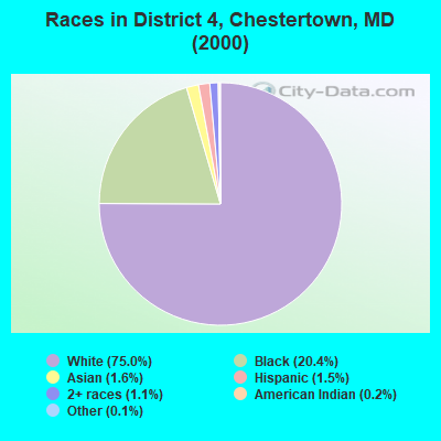
- 3,91375.0%White alone
- 1,06420.4%Black alone
- 831.6%Asian alone
- 781.5%Hispanic
- 581.1%Two or more races
- 90.2%American Indian alone
- 50.10%Native Hawaiian and Other
Pacific Islander alone - 70.1%Other race alone
Races in District 4, Chestertown detailed stats: ancestries, foreign born residents, place of birth
 Recent articles from our blog. Our writers, many of them Ph.D. graduates or candidates, create easy-to-read articles on a wide variety of topics.
Current Local Time: EST time zone
Land area: 8.48 square miles.
Population density: 635 people per square mile (low).

| District 4, Chestertown: | 1.2% ($1,627) |
| Maryland: | 1.2% ($1,782) |
Nearest city with pop. 50,000+: Dundalk, MD  (23.6 miles , pop. 62,306).
Nearest city with pop. 200,000+: Baltimore, MD (30.0 miles , pop. 651,154).
Nearest city with pop. 1,000,000+: Philadelphia, PA (73.0 miles , pop. 1,517,550).
Nearest cities:
), ), ), ), ), Latitude: 39.22 N, Longitude: 76.07 W
Area code commonly used in this area: 410

| Here: | 2.1% |
| Maryland: | 2.0% |
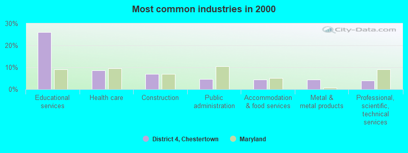
- Educational services (26.2%)
- Health care (8.7%)
- Construction (7.1%)
- Public administration (4.6%)
- Accommodation & food services (4.5%)
- Metal & metal products (4.4%)
- Professional, scientific, technical services (4.0%)
- Educational services (18.2%)
- Construction (14.3%)
- Metal & metal products (7.3%)
- Arts, entertainment, recreation (5.1%)
- Health care (4.8%)
- Professional, scientific, technical services (4.6%)
- Public administration (4.0%)
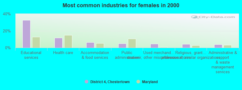
- Educational services (32.4%)
- Health care (11.7%)
- Accommodation & food services (6.2%)
- Public administration (5.1%)
- Used merchandise, gift, novelty, souvenir, other miscellaneous stores (4.7%)
- Religious, grantmaking, civic, professional, similar organizations (4.2%)
- Administrative & support & waste management services (3.9%)
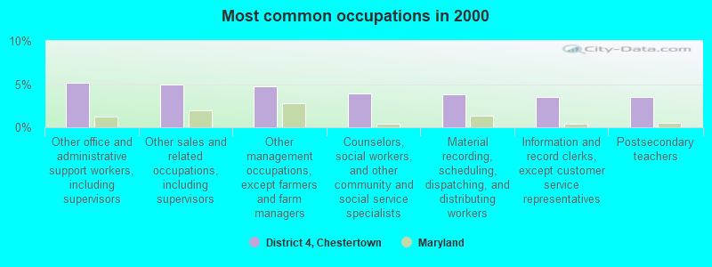
- Other office and administrative support workers, including supervisors (5.1%)
- Other sales and related occupations, including supervisors (5.0%)
- Other management occupations, except farmers and farm managers (4.7%)
- Counselors, social workers, and other community and social service specialists (3.9%)
- Material recording, scheduling, dispatching, and distributing workers (3.9%)
- Information and record clerks, except customer service representatives (3.5%)
- Postsecondary teachers (3.5%)
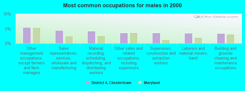
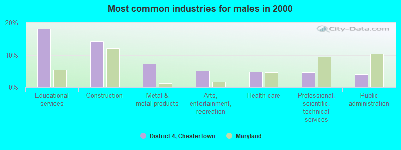
- Other management occupations, except farmers and farm managers (5.4%)
- Sales representatives, services, wholesale and manufacturing (4.5%)
- Material recording, scheduling, dispatching, and distributing workers (4.2%)
- Other sales and related occupations, including supervisors (3.6%)
- Supervisors, construction and extraction workers (3.6%)
- Laborers and material movers, hand (3.5%)
- Building and grounds cleaning and maintenance occupations (3.4%)
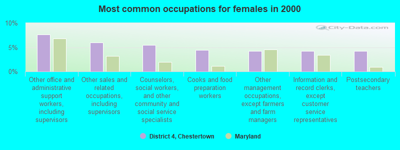
- Other office and administrative support workers, including supervisors (7.6%)
- Other sales and related occupations, including supervisors (6.0%)
- Counselors, social workers, and other community and social service specialists (5.5%)
- Cooks and food preparation workers (4.4%)
- Other management occupations, except farmers and farm managers (4.2%)
- Information and record clerks, except customer service representatives (4.2%)
- Postsecondary teachers (4.2%)
Average climate in District 4, Chestertown, Maryland
Based on data reported by over 4,000 weather stations


(lower is better)
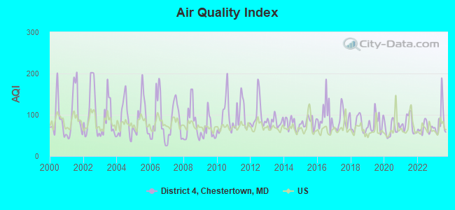
Air Quality Index (AQI) level in 2023 was 84.9. This is about average.
| City: | 84.9 |
| U.S.: | 72.6 |
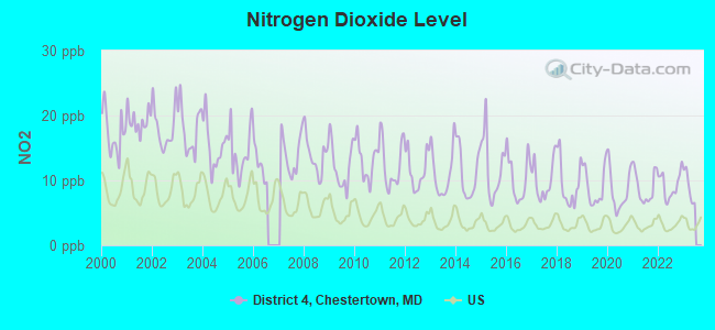
Nitrogen Dioxide (NO2) [ppb] level in 2022 was 9.24. This is significantly worse than average. Closest monitor was 18.0 miles away from the city center.
| City: | 9.24 |
| U.S.: | 5.11 |
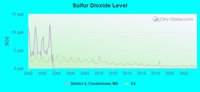
Sulfur Dioxide (SO2) [ppb] level in 2002 was 5.75. This is significantly worse than average. Closest monitor was 16.2 miles away from the city center.
| City: | 5.75 |
| U.S.: | 1.51 |
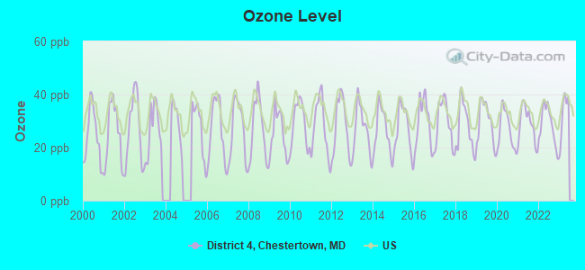
Ozone [ppb] level in 2022 was 28.5. This is about average. Closest monitor was 15.0 miles away from the city center.
| City: | 28.5 |
| U.S.: | 33.3 |
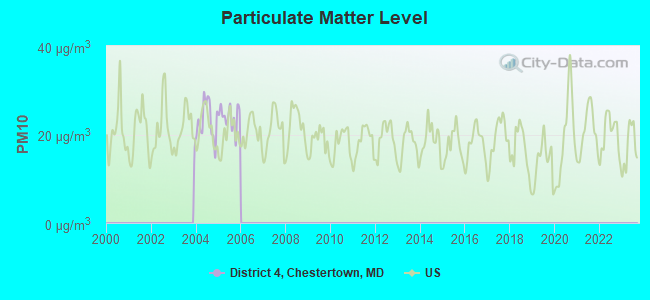
Particulate Matter (PM10) [µg/m3] level in 2005 was 24.0. This is worse than average. Closest monitor was 20.4 miles away from the city center.
| City: | 24.0 |
| U.S.: | 19.2 |
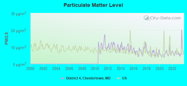
Particulate Matter (PM2.5) [µg/m3] level in 2023 was 7.88. This is about average. Closest monitor was 15.7 miles away from the city center.
| City: | 7.88 |
| U.S.: | 8.11 |
Tornado activity:
District 4, Chestertown-area historical tornado activity is near Maryland state average. It is 3% greater than the overall U.S. average.
On 6/9/1961, a category F3 (max. wind speeds 158-206 mph) tornado 28.5 miles away from the District 4, Chestertown city center caused between $50,000 and $500,000 in damages.
On 7/27/1994, a category F2 (max. wind speeds 113-157 mph) tornado 4.5 miles away from the city center caused between $500,000 and $5,000,000 in damages.
Earthquake activity:
District 4, Chestertown-area historical earthquake activity is significantly above Maryland state average. It is 62% smaller than the overall U.S. average.On 8/23/2011 at 17:51:04, a magnitude 5.8 (5.8 MW, Depth: 3.7 mi, Class: Moderate, Intensity: VI - VII) earthquake occurred 135.7 miles away from the city center
On 1/16/1994 at 01:49:16, a magnitude 4.6 (4.6 MB, 4.6 LG, Depth: 3.1 mi, Class: Light, Intensity: IV - V) earthquake occurred 76.8 miles away from the city center
On 11/30/2017 at 21:47:31, a magnitude 4.1 (4.1 MW, Depth: 6.1 mi) earthquake occurred 34.1 miles away from the city center
On 8/25/2011 at 05:07:52, a magnitude 4.5 (4.5 ML, Depth: 4.2 mi) earthquake occurred 135.2 miles away from the city center
On 1/16/1994 at 00:42:43, a magnitude 4.2 (4.2 MB, 4.0 LG, Depth: 3.1 mi) earthquake occurred 76.7 miles away from the city center
On 9/25/1998 at 19:52:52, a magnitude 5.2 (4.8 MB, 4.3 MS, 5.2 LG, 4.5 MW, Depth: 3.1 mi) earthquake occurred 276.9 miles away from the city center
Magnitude types: regional Lg-wave magnitude (LG), body-wave magnitude (MB), local magnitude (ML), surface-wave magnitude (MS), moment magnitude (MW)
Natural disasters:
The number of natural disasters in Kent County (18) is near the US average (15).Major Disasters (Presidential) Declared: 13
Emergencies Declared: 5
Causes of natural disasters: Hurricanes: 7, Winter Storms: 5, Snowstorms: 4, Blizzard: 1, Flood: 1, Heavy Rain: 1, Snowfall: 1, Storm: 1, Tropical Storm: 1, Wind: 1, Other: 1 (Note: some incidents may be assigned to more than one category).
Hospitals and medical centers near District 4, Chestertown:
- TOTAL RENAL CARE - CHESTERTOWN (Dialysis Facility, about 1 miles away; CHESTERTOWN, MD)
- UNIVERSITY OF MD SHORE MEDICAL CTR AT CHESTERTOWN Acute Care Hospitals (about 1 miles away; CHESTERTOWN, MD)
- HERON POINT OF CHESTERTOWN (Nursing Home, about 1 miles away; CHESTERTOWN, MD)
- CHESTER RIVER MANOR (Nursing Home, about 1 miles away; CHESTERTOWN, MD)
- CHESTERTOWN NURSING AND REHAB CT (Nursing Home, about 1 miles away; CHESTERTOWN, MD)
- KENT CNTY HLTH DEPTMNT (Home Health Center, about 1 miles away; CHESTERTOWN, MD)
- CHESTER RIVER HOME CARE (Home Health Center, about 3 miles away; CHESTERTOWN, MD)
Colleges/universities with over 2000 students nearest to District 4, Chestertown:
- The Community College of Baltimore County (about 24 miles; Baltimore, MD; Full-time enrollment: 15,217)
- All-State Career-Baltimore (about 26 miles; Baltimore, MD; FT enrollment: 2,287)
- Harford Community College (about 27 miles; Bel Air, MD; FT enrollment: 4,530)
- Anne Arundel Community College (about 27 miles; Arnold, MD; FT enrollment: 10,501)
- Delaware Technical Community College-Terry (about 28 miles; Dover, DE; FT enrollment: 2,239)
- United States Naval Academy (about 28 miles; Annapolis, MD; FT enrollment: 5,681)
- Delaware State University (about 29 miles; Dover, DE; FT enrollment: 4,087)
Points of interest:
Notable locations in District 4, Chestertown: Chestertown Business Park (A), Radcliff Creek Industrial Park (B), Scott Point Marina (C), Schottland Tennis Pavilion (D), Chestertown Volunteer Fire Company Incorporated Station 6 (E), Kent and Queen Annes Rescue Squad (F), Chestertown Nursing and Rehabilitation Center (G), The Customs House (H), White Swan Tavern (I), Wide Hall (J), Worcester Hall (K), William Smith Hall (L), Truslow Boat House (M), The John S Toll Science Center Complex (N), Talbot House (O), Somerset House (P), Sears House (Q), Saint Mary's House (R), Rose O'Neill Literary House (S), Queen Anne's House (T). Display/hide their locations on the map
Shopping Centers: Crestview Square Shopping Center (1), Kent Plaza Shopping Center (2). Display/hide their locations on the map
Churches in District 4, Chestertown include: Church on the Rock (A), Bethel African Methodist Episcopal Church (B), Chestertown Baptist Church (C), Chestertown Seventh Day Adventist Church (D), Christ United Methodist Church (E), Emmanuel Episcopal Church (F), First Baptist Church (G), First United Methodist Church (H), Janes United Methodist Church (I). Display/hide their locations on the map
Cemetery: Chestertown Cemetery (1). Display/hide its location on the map
Parks in District 4, Chestertown include: Chestertown Historic District (1), Wilmer Park (2), Athey Field (3), Kibler Field (4), Kirwan Meditation Garden (5), Shriver Field (6). Display/hide their locations on the map
| This city: | 2.0 people |
| Maryland: | 2.6 people |
| This city: | 52.1% |
| Whole state: | 67.1% |
| This city: | 6.7% |
| Whole state: | 6.4% |
Likely homosexual households (counted as self-reported same-sex unmarried-partner households)
- Lesbian couples: 0.4% of all households
- Gay men: 0.1% of all households
| This city: | 16.9% |
| Whole state: | 8.5% |
| This city: | 8.5% |
| Whole state: | 4.2% |
People in group quarters in District 4, Chestertown in 2010:
- 1,035 people in college/university student housing
- 192 people in nursing facilities/skilled-nursing facilities
- 77 people in local jails and other municipal confinement facilities
- 13 people in emergency and transitional shelters (with sleeping facilities) for people experiencing homelessness
- 12 people in residential treatment centers for adults
- 11 people in correctional facilities intended for juveniles
- 10 people in group homes intended for adults
People in group quarters in District 4, Chestertown in 2000:
- 743 people in college dormitories (includes college quarters off campus)
- 201 people in nursing homes
- 46 people in local jails and other confinement facilities (including police lockups)
- 34 people in homes or halfway houses for drug/alcohol abuse
- 32 people in mental (psychiatric) hospitals or wards
- 29 people in short-term care, detention or diagnostic centers for delinquent children
- 16 people in hospitals or wards for drug/alcohol abuse
- 14 people in homes for the mentally ill
- 5 people in other group homes
For population 15 years and over in District 4, Chestertown:
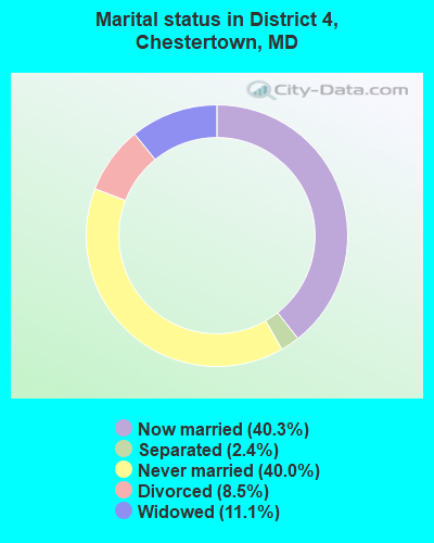
- Never married: 40.0%
- Now married: 40.3%
- Separated: 2.4%
- Widowed: 11.1%
- Divorced: 8.5%
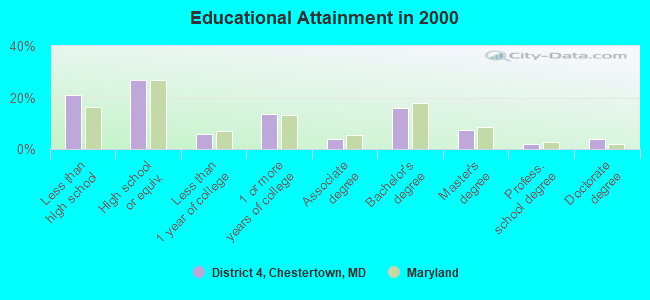
For population 25 years and over in District 4, Chestertown:
- High school or higher: 79.2%
- Bachelor's degree or higher: 29.1%
- Graduate or professional degree: 13.3%
- Unemployed: 4.0%
- Mean travel time to work (commute): 16.1 minutes
| Here: | 13.6 |
| Maryland average: | 12.7 |
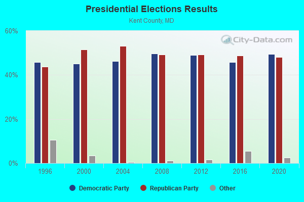
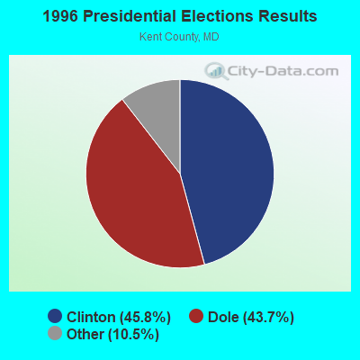
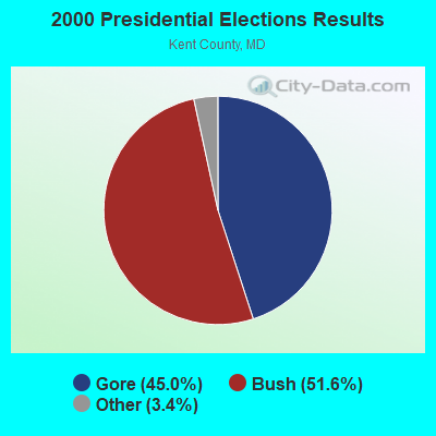
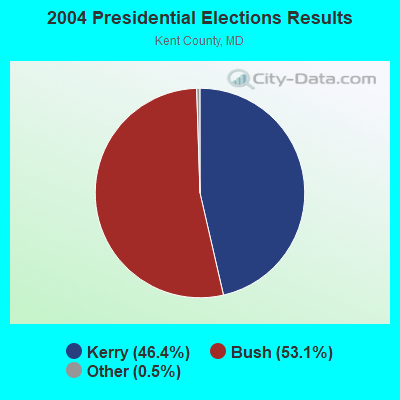
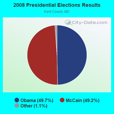
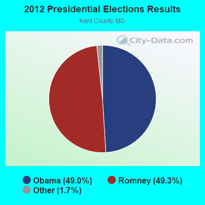
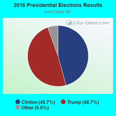
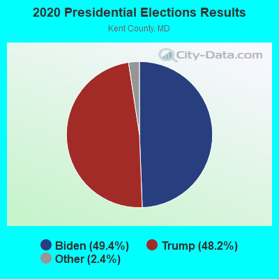
Graphs represent county-level data. Detailed 2008 Election Results
Religion statistics for District 4, Chestertown, MD (based on Kent County data)
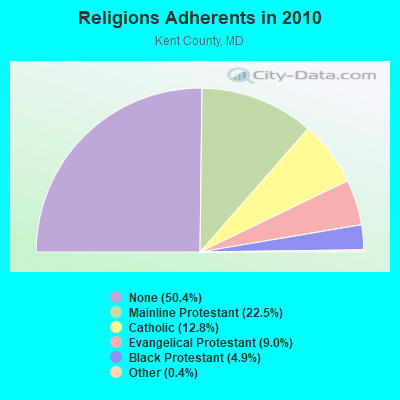
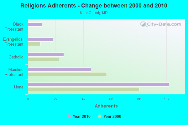
| Religion | Adherents | Congregations |
|---|---|---|
| Mainline Protestant | 4,551 | 27 |
| Catholic | 2,588 | 3 |
| Evangelical Protestant | 1,814 | 14 |
| Black Protestant | 984 | 6 |
| Other | 72 | 2 |
| None | 10,188 | - |
Food Environment Statistics:
| This county: | 2.01 / 10,000 pop. |
| State: | 1.96 / 10,000 pop. |
| This county: | 2.01 / 10,000 pop. |
| Maryland: | 1.22 / 10,000 pop. |
| This county: | 3.52 / 10,000 pop. |
| Maryland: | 2.05 / 10,000 pop. |
| Here: | 12.58 / 10,000 pop. |
| Maryland: | 5.40 / 10,000 pop. |
| This county: | 10.7% |
| State: | 9.1% |
| This county: | 28.1% |
| Maryland: | 26.7% |
| Here: | 14.0% |
| Maryland: | 15.5% |
Strongest AM radio stations in District 4, Chestertown:
- WCTR (1530 AM; daytime; 1 kW; CHESTERTOWN, MD)
- WWLG (1370 AM; 50 kW; BALTIMORE, MD; Owner: M-10 BROADCASTING, INC.)
- WBIS (1190 AM; 50 kW; ANNAPOLIS, MD; Owner: NATIONS RADIO, LLC)
- WCBM (680 AM; 50 kW; BALTIMORE, MD; Owner: WCBM MARYLAND, INC.)
- WBAL (1090 AM; 50 kW; BALTIMORE, MD; Owner: HEARST RADIO, INC.)
- WVCH (740 AM; 50 kW; CHESTER, PA; Owner: WVCH COMMUNICATIONS, INC.)
- WTEM (980 AM; 50 kW; WASHINGTON, DC; Owner: AMFM RADIO LICENSES, L.L.C.)
- WGOP (700 AM; daytime; 25 kW; WALKERSVILLE, MD; Owner: BIRACH BROADCASTING CORPORATION)
- WWGB (1030 AM; daytime; 50 kW; INDIAN HEAD, MD; Owner: GOOD BODY MEDIA, LLC)
- WPGC (1580 AM; 50 kW; MORNINGSIDE, MD; Owner: INFINITY WPGC(AM), INC.)
- WTOP (1500 AM; 50 kW; WASHINGTON, DC; Owner: BONNEVILLE HOLDING COMPANY)
- WMET (1150 AM; 50 kW; GAITHERSBURG, MD; Owner: BELTWAY ACQUISITION CORPORATION)
- WPEN (950 AM; 50 kW; PHILADELPHIA, PA; Owner: GREATER PHILADELPHIA RADIO, INC.)
Strongest FM radio stations in District 4, Chestertown:
- WWMX (106.5 FM; BALTIMORE, MD; Owner: INFINITY RADIO OPERATIONS INC.)
- WLIF (101.9 FM; BALTIMORE, MD; Owner: INFINITY WLIF, INC.)
- WIYY (97.9 FM; BALTIMORE, MD; Owner: HEARST RADIO, INC.)
- WXCY (103.7 FM; HAVRE DE GRACE, MD; Owner: DELMARVA BROADCASTING COMPANY)
- WPOC (93.1 FM; BALTIMORE, MD; Owner: CITICASTERS LICENSES, L.P.)
- WSMJ (104.3 FM; BALTIMORE, MD; Owner: CITICASTERS LICENSES, L.P.)
- WXYV (105.7 FM; CATONSVILLE, MD; Owner: INFINITY RADIO OPERATIONS INC.)
- WRNR-FM (103.1 FM; GRASONVILLE, MD; Owner: EMPIRE BROADCASTING SYSTEM, INC.)
- WZBA (100.7 FM; WESTMINSTER, MD; Owner: SHAMROCK COMMUNICATIONS, INC.)
- WERQ-FM (92.3 FM; BALTIMORE, MD; Owner: RADIO ONE LICENSES, LLC)
- WRDX (94.7 FM; DOVER, DE; Owner: CAPSTAR TX LIMITED PARTNERSHIP)
- WKHS (90.5 FM; WORTON, MD; Owner: BOARD OF EDUCATION OF KENT COUNTY)
TV broadcast stations around District 4, Chestertown:
- WTSD-CA (Channel 14; WILMINGTON, DE; Owner: PRIORITY COMMUNICATIONS MINISTRIES, INC.)
- WBAL-TV (Channel 11; BALTIMORE, MD; Owner: WBAL HEARST-ARGYLE TV, INC. (CA CORP.))
- WMAR-TV (Channel 2; BALTIMORE, MD; Owner: SCRIPPS HOWARD BROADCASTING COMPANY)
- WBFF (Channel 45; BALTIMORE, MD; Owner: CHESAPEAKE TELEVISION LICENSEE, LLC)
- WNUV (Channel 54; BALTIMORE, MD; Owner: BALTIMORE (WNUV-TV) LICENSEE, INC.)
- WJZ-TV (Channel 13; BALTIMORE, MD; Owner: VIACOM INC.)
- WMPT (Channel 22; ANNAPOLIS, MD; Owner: MARYLAND PUBLIC BROADCASTING COMMISSION)
- WMPB (Channel 67; BALTIMORE, MD; Owner: MARYLAND PUBLIC BROADCASTING COMMISSION)
- WUTB (Channel 24; BALTIMORE, MD; Owner: FOX TELEVISION STATIONS, INC.)
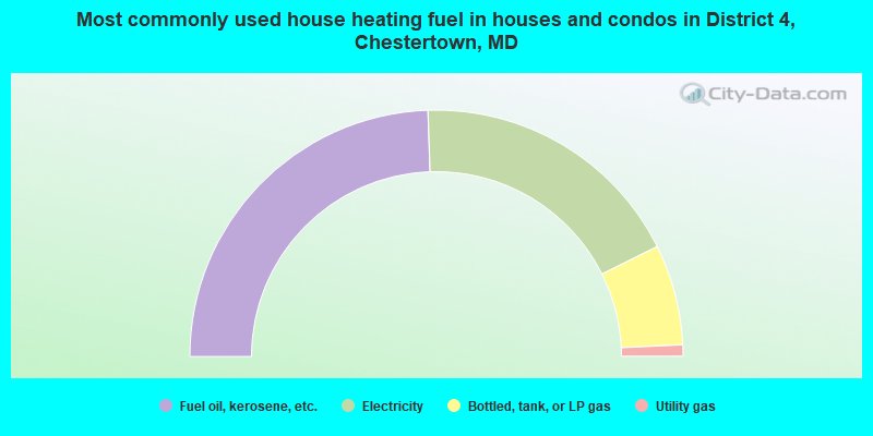
- 48.9%Fuel oil, kerosene, etc.
- 36.4%Electricity
- 13.2%Bottled, tank, or LP gas
- 1.5%Utility gas
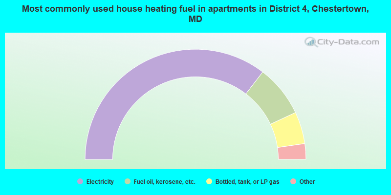
- 70.9%Electricity
- 15.2%Fuel oil, kerosene, etc.
- 9.4%Bottled, tank, or LP gas
- 3.1%Utility gas
- 0.7%Other fuel
- 0.7%No fuel used
District 4, Chestertown compared to Maryland state average:
- Median household income below state average.
- Unemployed percentage significantly below state average.
- Hispanic race population percentage significantly below state average.
- Foreign-born population percentage significantly below state average.
- Length of stay since moving in significantly above state average.
- Number of rooms per house significantly below state average.
- House age significantly below state average.
- Institutionalized population percentage significantly above state average.
- Number of college students above state average.
District 4, Chestertown on our top lists:
- #4 on the list of "Top 101 cities with largest percentage of females in occupations: counselors, social workers, and other community and social service specialists (population 5,000+)"
- #5 on the list of "Top 101 cities with largest percentage of females in industries: used merchandise, gift, novelty, and souvenir, and other miscellaneous stores (population 5,000+)"
- #6 on the list of "Top 101 cities with largest percentage of males in occupations: social scientists and related workers (population 5,000+)"
- #12 on the list of "Top 101 cities with largest percentage of males in occupations: entertainers and performers, sports, and related workers (population 5,000+)"
- #12 on the list of "Top 101 cities with largest percentage of females in occupations: postsecondary teachers (population 5,000+)"
- #13 on the list of "Top 101 cities with largest percentage of males in occupations: information and record clerks except customer service representatives (population 5,000+)"
- #13 on the list of "Top 101 cities with largest percentage of males in occupations: transportation, tourism, and lodging attendants (population 5,000+)"
- #22 on the list of "Top 101 cities with largest percentage of females in industries: religious, grantmaking, civic, professional, and similar organizations (population 5,000+)"
- #26 on the list of "Top 101 cities with largest percentage of females in industries: paper (population 5,000+)"
- #32 on the list of "Top 101 cities with largest percentage of males in industries: u. s. postal service (population 5,000+)"
- #34 on the list of "Top 101 cities with largest percentage of males in industries: other direct selling establishments (population 5,000+)"
- #37 on the list of "Top 101 cities with the most people walking to work (population 5,000+)"
- #37 on the list of "Top 101 cities with largest percentage of males in industries: music stores (population 5,000+)"
- #42 on the list of "Top 100 cities with the largest percentage of females (pop. 5,000+)"
- #48 on the list of "Top 101 cities with the largest percentage of people in short-term care, detention or diagnostic centers for delinquent children (population 1,000+)"
- #64 on the list of "Top 101 cities with largest percentage of males in industries: metal and metal products (population 5,000+)"
- #65 on the list of "Top 101 cities with the largest percentage of people in hospitals or wards for drug/alcohol abuse (population 1,000+)"
- #78 on the list of "Top 100 cities with highest percentage of college students (pop. 5,000+)"
- #83 on the list of "Top 101 cities with largest percentage of females in industries: educational services (population 5,000+)"
- #85 on the list of "Top 101 cities with largest percentage of males in industries: petroleum and coal products (population 5,000+)"
- #95 on the list of "Top 101 counties with the highest Particulate Matter (PM2.5) Annual air pollution readings in 2012 (µg/m3)"