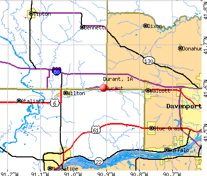
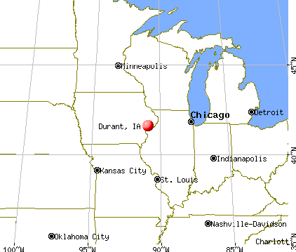
Durant, Iowa
Submit your own pictures of this city and show them to the world
- OSM Map
- General Map
- Google Map
- MSN Map
Population change since 2000: +10.3%
 |
| Males: 918 | |
| Females: 932 |
| Median resident age: | 42.7 years |
| Iowa median age: | 38.9 years |
| Durant: | $75,558 |
| IA: | $69,588 |
Estimated per capita income in 2022: $42,669 (it was $19,399 in 2000)
Durant city income, earnings, and wages data
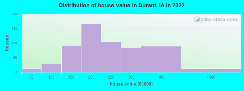
Estimated median house or condo value in 2022: $207,138 (it was $89,900 in 2000)
| Durant: | $207,138 |
| IA: | $194,600 |
Mean prices in 2022: all housing units: $232,238; detached houses: $241,839; townhouses or other attached units: $192,911; in 2-unit structures: $290,136; in 3-to-4-unit structures: $151,393; in 5-or-more-unit structures: $181,876; mobile homes: $47,996
Median gross rent in 2022: $774.
(7.2% for White Non-Hispanic residents, 52.9% for Black residents)
Detailed information about poverty and poor residents in Durant, IA

Compare current foreclosures near Durant, IA:
| Photo | Address | Area | Beds / Baths | Price | Details |
|---|---|---|---|---|---|

|
#1
10th Ave
Durant, IA 52747
|
1,447 sq. feet
|
1 baths 2 beds |
show details | |

|
#2
6th St
Durant, IA 52747
|
1,244 sq. feet
|
1 baths 3 beds |
show details | |

|
#3
150th St
Durant, IA 52747
|
- sq. feet
|
- baths - beds |
show details | |

|
#4
N Lincoln Ave
Davenport, IA 52804
|
952 sq. feet
|
1 baths 2 beds |
$179,900
|
show details |

|
#5
Clinton St
Muscatine, IA 52761
|
1,076 sq. feet
|
1 baths 2 beds |
$159,500
|
show details |

|
#6
5th St
Buffalo, IA 52728
|
- sq. feet
|
2 baths 4 beds |
$26,000
|
show details |

|
#7
139th St W
Taylor Ridge, IL 61284
|
720 sq. feet
|
1 baths 2 beds |
show details | |

|
#8
Cypress St
Muscatine, IA 52761
|
1,117 sq. feet
|
1 baths 3 beds |
show details | |

|
#9
W 54th St
Davenport, IA 52806
|
1,180 sq. feet
|
1 baths 2 beds |
show details | |

|
#10
N Elsie Ave
Davenport, IA 52806
|
916 sq. feet
|
2 baths 4 beds |
show details |
| Photo | Address | Area | Beds / Baths | Price | Details |
|---|---|---|---|---|---|

|
#11
78th Ave W
Taylor Ridge, IL 61284
|
1,288 sq. feet
|
2 baths 3 beds |
show details | |

|
#12
Mulberry Ave
Muscatine, IA 52761
|
1,201 sq. feet
|
1 baths 3 beds |
show details | |

|
#13
Waverly Rd
Davenport, IA 52804
|
1,194 sq. feet
|
1 baths 2 beds |
show details | |

|
#14
Mulberry St
Tipton, IA 52772
|
2,452 sq. feet
|
2 baths 5 beds |
show details | |

|
#15
Rockingham Rd
Davenport, IA 52802
|
1,666 sq. feet
|
2 baths 3 beds |
show details | |

|
#16
E 9th St
Muscatine, IA 52761
|
2,084 sq. feet
|
1 baths 5 beds |
show details | |

|
#17
E 1st Ave
Donahue, IA 52746
|
1,680 sq. feet
|
1 baths 4 beds |
show details | |

|
#18
Locust St
Tipton, IA 52772
|
1,953 sq. feet
|
1 baths 3 beds |
show details | |

|
#19
290th St
Atalissa, IA 52720
|
982 sq. feet
|
1 baths 3 beds |
show details | |

|
#20
Busch St
Muscatine, IA 52761
|
1,696 sq. feet
|
2 baths 3 beds |
show details |
| Photo | Address | Area | Beds / Baths | Price | Details |
|---|---|---|---|---|---|

|
#21
N 8th St
Eldridge, IA 52748
|
972 sq. feet
|
2 baths 4 beds |
show details | |

|
#22
Devitt Ave
Muscatine, IA 52761
|
2,604 sq. feet
|
1 baths 3 beds |
show details | |

|
#23
E 2nd St
Tipton, IA 52772
|
937 sq. feet
|
1 baths 2 beds |
show details | |

|
#24
W 6th St
Muscatine, IA 52761
|
1,218 sq. feet
|
1 baths 2 beds |
show details | |

|
#25
Sunset Bch
Montpelier, IA 52759
|
1,516 sq. feet
|
1 baths 3 beds |
show details | |

|
#26
Buell St
Muscatine, IA 52761
|
1,325 sq. feet
|
1 baths 3 beds |
show details | |

|
#27
Park Ave
Muscatine, IA 52761
|
1,448 sq. feet
|
1 baths 4 beds |
show details | |

|
#28
Sherman St
Muscatine, IA 52761
|
1,228 sq. feet
|
1 baths 2 beds |
show details | |

|
#29
E 4th St
Tipton, IA 52772
|
1,596 sq. feet
|
1 baths 3 beds |
show details | |

|
#30
W 2nd St
Tipton, IA 52772
|
1,575 sq. feet
|
1 baths 4 beds |
show details |
| Photo | Address | Area | Beds / Baths | Price | Details |
|---|---|---|---|---|---|

|
#31
Bryan Ave
Muscatine, IA 52761
|
2,720 sq. feet
|
1 baths 3 beds |
show details | |

|
#32
Grand Ave
Muscatine, IA 52761
|
1,247 sq. feet
|
1 baths 3 beds |
show details | |

|
#33
Cobblestone Dr
Muscatine, IA 52761
|
1,552 sq. feet
|
1 baths 3 beds |
show details | |

|
#34
E 7th St
Tipton, IA 52772
|
1,732 sq. feet
|
1 baths 4 beds |
show details | |

|
#35
Hummingbird Ln
Muscatine, IA 52761
|
2,370 sq. feet
|
1 baths 4 beds |
show details | |

|
#36
Hershey Ave
Muscatine, IA 52761
|
1,352 sq. feet
|
1 baths 3 beds |
show details | |

|
#37
Sweetland Rd
Muscatine, IA 52761
|
2,123 sq. feet
|
2 baths 3 beds |
show details | |

|
#38
Iowa Ave
Muscatine, IA 52761
|
1,336 sq. feet
|
1 baths 3 beds |
show details | |

|
#39
W Hayes St
Davenport, IA 52804
|
- sq. feet
|
- baths - beds |
show details | |

|
#40
W 55th St
Davenport, IA 52806
|
- sq. feet
|
- baths - beds |
show details |
| Photo | Address | Area | Beds / Baths | Price | Details |
|---|---|---|---|---|---|

|
#41
Welshire Dr
Davenport, IA 52806
|
- sq. feet
|
- baths - beds |
show details | |

|
#42
E Vine St
Wheatland, IA 52777
|
- sq. feet
|
- baths - beds |
show details | |

|
#43
Cyril Ave
Muscatine, IA 52761
|
- sq. feet
|
- baths - beds |
show details | |

|
#44
E South St
Tipton, IA 52772
|
- sq. feet
|
- baths - beds |
show details | |

|
#45
W 15th St Apt 131
Davenport, IA 52804
|
- sq. feet
|
- baths - beds |
show details | |

|
#46
N 7th St
Eldridge, IA 52748
|
- sq. feet
|
- baths - beds |
show details | |

|
#47
W 61st St
Davenport, IA 52806
|
- sq. feet
|
- baths - beds |
show details | |

|
#48
N Nevada Ave
Davenport, IA 52804
|
- sq. feet
|
- baths - beds |
show details | |

|
#49
Jefferson St
Buffalo, IA 52728
|
- sq. feet
|
- baths - beds |
show details | |

|
Check over 1 million property listings on Foreclosure.com!
|
browse all offers | |||


- 1,74391.4%White alone
- 623.2%Two or more races
- 562.9%Hispanic
- 221.2%Asian alone
- 140.7%Black alone
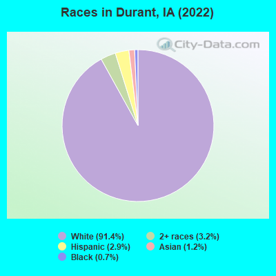
Races in Durant detailed stats: ancestries, foreign born residents, place of birth
Type |
2020 |
2021 |
2022 |
|---|---|---|---|
| Murders (per 100,000) | 0 (0.0) | 0 (0.0) | 0 (0.0) |
| Rapes (per 100,000) | 1 (53.6) | 0 (0.0) | 0 (0.0) |
| Robberies (per 100,000) | 0 (0.0) | 0 (0.0) | 0 (0.0) |
| Assaults (per 100,000) | 0 (0.0) | 0 (0.0) | 0 (0.0) |
| Burglaries (per 100,000) | 3 (160.9) | 0 (0.0) | 1 (54.3) |
| Thefts (per 100,000) | 9 (482.8) | 4 (215.5) | 3 (162.9) |
| Auto thefts (per 100,000) | 1 (53.6) | 0 (0.0) | 0 (0.0) |
| Arson (per 100,000) | 0 (0.0) | 0 (0.0) | 0 (0.0) |
| City-Data.com crime index | 77.8 | 8.6 | 10.3 |
The City-Data.com crime index weighs serious crimes and violent crimes more heavily. Higher means more crime, U.S. average is 246.1. It adjusts for the number of visitors and daily workers commuting into cities.
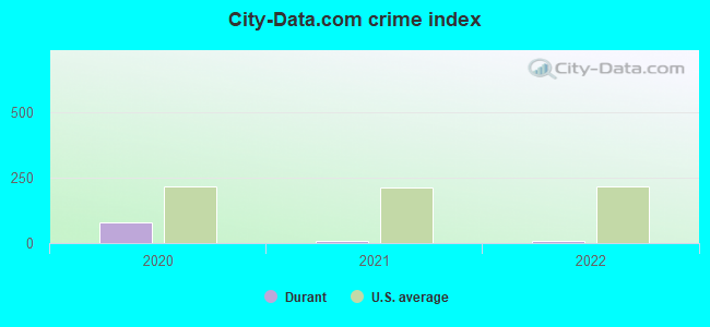
Crime rate in Durant detailed stats: murders, rapes, robberies, assaults, burglaries, thefts, arson
Full-time law enforcement employees in 2021, including police officers: 4 (4 officers - 4 male; 0 female).
| Officers per 1,000 residents here: | 2.16 |
| Iowa average: | 1.76 |
 Recent articles from our blog. Our writers, many of them Ph.D. graduates or candidates, create easy-to-read articles on a wide variety of topics.

 | Moving to QC. Looking for info (18 replies) |
| Questions from a Texas looking to move (10 replies) |
| Smaller IA Cities (7 replies) |
| Moving to Muscatine (5 replies) |
| Rental homes in Davenport, Iowa...help! (2 replies) |
| Relocating to The QC (9 replies) |
Latest news from Durant, IA collected exclusively by city-data.com from local newspapers, TV, and radio stations
Ancestries: German (51.6%), American (7.9%), English (5.4%), Irish (5.0%), Scottish (2.9%), Swedish (1.8%).
Current Local Time: CST time zone
Incorporated on 07/1/1867
Elevation: 710 feet
Land area: 1.00 square miles.
Population density: 1,859 people per square mile (low).
29 residents are foreign born
| This city: | 1.5% |
| Iowa: | 5.6% |
Median real estate property taxes paid for housing units with mortgages in 2022: $2,598 (1.3%)
Median real estate property taxes paid for housing units with no mortgage in 2022: $3,039 (1.5%)
Nearest city with pop. 50,000+: Davenport, IA  (17.0 miles , pop. 98,359).
Nearest city with pop. 200,000+: Madison, WI (128.0 miles , pop. 208,054).
Nearest city with pop. 1,000,000+: Chicago, IL (167.6 miles , pop. 2,896,016).
Nearest cities:
), ), )Latitude: 41.60 N, Longitude: 90.91 W
Area code: 563


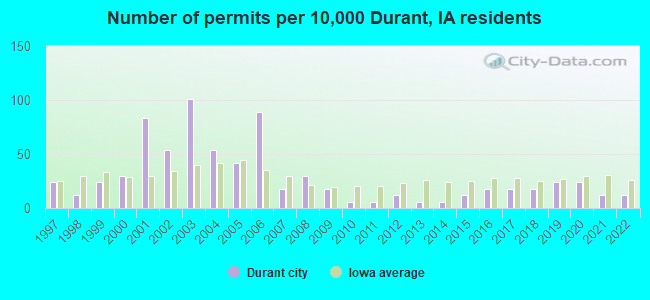
Single-family new house construction building permits:
- 2022: 2 buildings, average cost: $169,000
- 2021: 2 buildings, average cost: $291,000
- 2020: 4 buildings, average cost: $219,300
- 2019: 4 buildings, average cost: $173,800
- 2018: 3 buildings, average cost: $167,900
- 2017: 3 buildings, average cost: $170,000
- 2016: 3 buildings, average cost: $146,000
- 2015: 2 buildings, average cost: $227,500
- 2014: 1 building, cost: $254,200
- 2013: 1 building, cost: $160,000
- 2012: 2 buildings, average cost: $226,000
- 2011: 1 building, cost: $195,000
- 2010: 1 building, cost: $224,000
- 2009: 3 buildings, average cost: $199,000
- 2008: 5 buildings, average cost: $264,400
- 2007: 3 buildings, average cost: $186,300
- 2006: 15 buildings, average cost: $173,900
- 2005: 7 buildings, average cost: $160,600
- 2004: 9 buildings, average cost: $183,100
- 2003: 17 buildings, average cost: $142,300
- 2002: 9 buildings, average cost: $151,100
- 2001: 14 buildings, average cost: $137,200
- 2000: 5 buildings, average cost: $119,600
- 1999: 4 buildings, average cost: $105,300
- 1998: 2 buildings, average cost: $135,000
- 1997: 4 buildings, average cost: $110,000
| Here: | 2.7% |
| Iowa: | 2.7% |
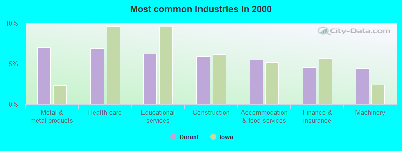
- Metal & metal products (7.0%)
- Health care (6.9%)
- Educational services (6.2%)
- Construction (5.9%)
- Accommodation & food services (5.4%)
- Finance & insurance (4.5%)
- Machinery (4.4%)
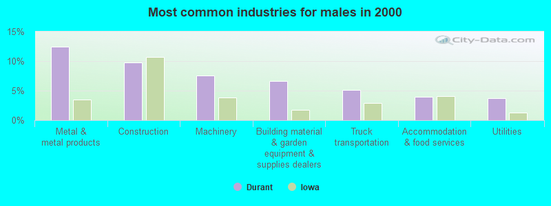
- Metal & metal products (12.4%)
- Construction (9.8%)
- Machinery (7.5%)
- Building material & garden equipment & supplies dealers (6.7%)
- Truck transportation (5.1%)
- Accommodation & food services (4.0%)
- Utilities (3.8%)
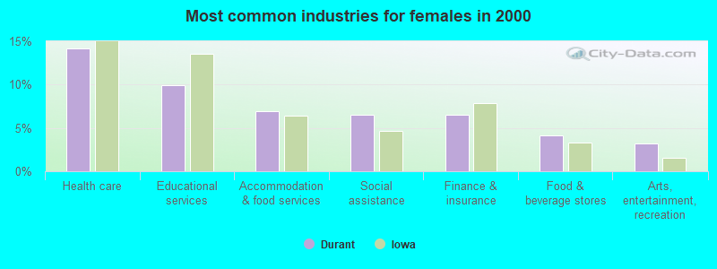
- Health care (14.2%)
- Educational services (10.0%)
- Accommodation & food services (7.0%)
- Social assistance (6.5%)
- Finance & insurance (6.5%)
- Food & beverage stores (4.2%)
- Arts, entertainment, recreation (3.2%)
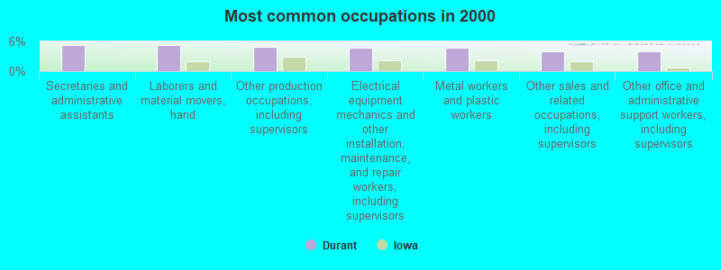
- Secretaries and administrative assistants (5.3%)
- Laborers and material movers, hand (5.2%)
- Other production occupations, including supervisors (5.0%)
- Electrical equipment mechanics and other installation, maintenance, and repair workers, including supervisors (4.6%)
- Metal workers and plastic workers (4.6%)
- Other sales and related occupations, including supervisors (4.0%)
- Other office and administrative support workers, including supervisors (4.0%)
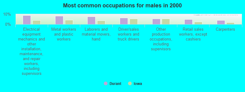
- Electrical equipment mechanics and other installation, maintenance, and repair workers, including supervisors (8.6%)
- Metal workers and plastic workers (8.2%)
- Laborers and material movers, hand (7.5%)
- Driver/sales workers and truck drivers (6.4%)
- Other production occupations, including supervisors (5.5%)
- Retail sales workers, except cashiers (4.9%)
- Carpenters (4.0%)
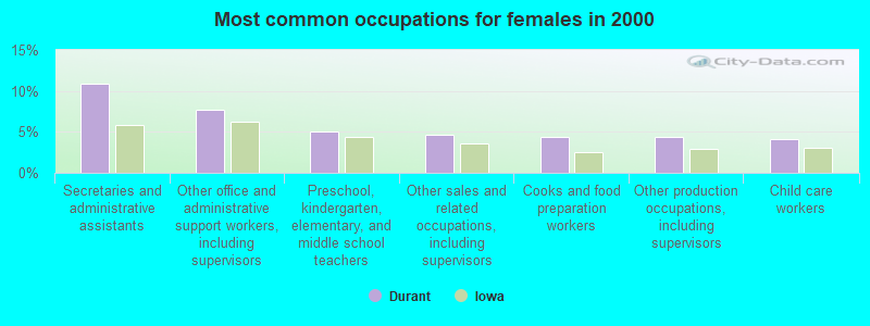
- Secretaries and administrative assistants (10.9%)
- Other office and administrative support workers, including supervisors (7.7%)
- Preschool, kindergarten, elementary, and middle school teachers (5.1%)
- Other sales and related occupations, including supervisors (4.6%)
- Cooks and food preparation workers (4.4%)
- Other production occupations, including supervisors (4.4%)
- Child care workers (4.2%)
Average climate in Durant, Iowa
Based on data reported by over 4,000 weather stations


|
|


(lower is better)
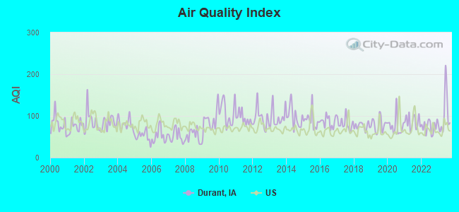
Air Quality Index (AQI) level in 2023 was 101. This is worse than average.
| City: | 101 |
| U.S.: | 73 |
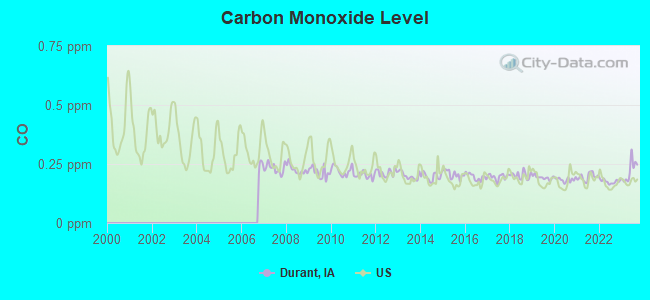
Carbon Monoxide (CO) [ppm] level in 2023 was 0.220. This is about average. Closest monitor was 17.4 miles away from the city center.
| City: | 0.220 |
| U.S.: | 0.251 |
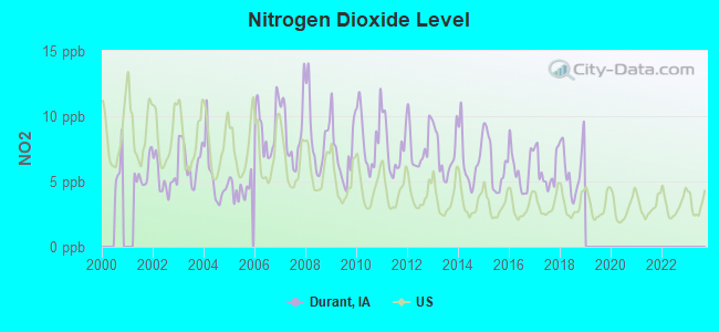
Nitrogen Dioxide (NO2) [ppb] level in 2018 was 6.00. This is about average. Closest monitor was 17.4 miles away from the city center.
| City: | 6.00 |
| U.S.: | 5.11 |
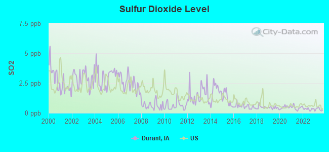
Sulfur Dioxide (SO2) [ppb] level in 2023 was 0.300. This is significantly better than average. Closest monitor was 14.2 miles away from the city center.
| City: | 0.300 |
| U.S.: | 1.515 |
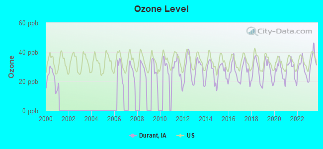
Ozone [ppb] level in 2023 was 33.9. This is about average. Closest monitor was 17.1 miles away from the city center.
| City: | 33.9 |
| U.S.: | 33.3 |
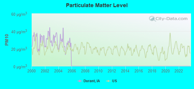
Particulate Matter (PM10) [µg/m3] level in 2005 was 23.6. This is worse than average. Closest monitor was 14.7 miles away from the city center.
| City: | 23.6 |
| U.S.: | 19.2 |
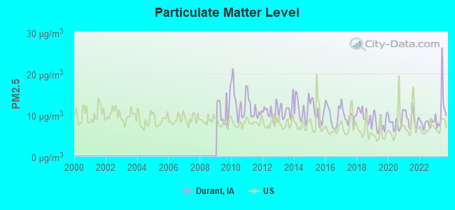
Particulate Matter (PM2.5) [µg/m3] level in 2023 was 11.3. This is worse than average. Closest monitor was 15.1 miles away from the city center.
| City: | 11.3 |
| U.S.: | 8.1 |
Tornado activity:
Durant-area historical tornado activity is near Iowa state average. It is 85% greater than the overall U.S. average.
On 4/11/1965, a category F4 (max. wind speeds 207-260 mph) tornado 17.3 miles away from the Durant city center killed one person and injured 3 people and caused between $500,000 and $5,000,000 in damages.
On 5/9/1995, a category F3 (max. wind speeds 158-206 mph) tornado 2.5 miles away from the city center caused between $500,000 and $5,000,000 in damages.
Earthquake activity:
Durant-area historical earthquake activity is significantly above Iowa state average. It is 132% greater than the overall U.S. average.On 4/18/2008 at 09:36:59, a magnitude 5.4 (5.1 MB, 4.8 MS, 5.4 MW, 5.2 MW, Class: Moderate, Intensity: VI - VII) earthquake occurred 270.3 miles away from the city center
On 6/10/1987 at 23:48:54, a magnitude 5.1 (4.9 MB, 4.4 MS, 4.6 MS, 5.1 LG) earthquake occurred 249.9 miles away from the city center
On 4/18/2008 at 09:36:59, a magnitude 5.2 (5.2 MW, Depth: 8.9 mi) earthquake occurred 270.3 miles away from Durant center
On 6/28/2004 at 06:10:52, a magnitude 4.2 (4.2 MW, Depth: 6.2 mi, Class: Light, Intensity: IV - V) earthquake occurred 104.5 miles away from the city center
On 6/18/2002 at 17:37:15, a magnitude 5.0 (4.3 MB, 4.6 MW, 5.0 LG) earthquake occurred 300.2 miles away from Durant center
On 4/18/2008 at 15:14:16, a magnitude 4.8 (4.5 MB, 4.8 MW, 4.6 MW) earthquake occurred 270.2 miles away from Durant center
Magnitude types: regional Lg-wave magnitude (LG), body-wave magnitude (MB), surface-wave magnitude (MS), moment magnitude (MW)
Natural disasters:
The number of natural disasters in Cedar County (16) is near the US average (15).Major Disasters (Presidential) Declared: 14
Emergencies Declared: 1
Causes of natural disasters: Floods: 11, Storms: 11, Tornadoes: 5, Winds: 2, Winter Storms: 2, Hurricane: 1, Other: 1 (Note: some incidents may be assigned to more than one category).

Hospitals and medical centers near Durant:
- BETHESDA CARE CENTER (Nursing Home, about 14 miles away; MUSCATINE, IA)
- CARRINGTON PLACE AT MUSCATINE (Nursing Home, about 14 miles away; MUSCATINE, IA)
- TRINITY MUSCATINE Acute Care Hospitals (about 14 miles away; MUSCATINE, IA)
- UNIVERSITY OF IOWA HOSPITAL AND CLINICS - MUSCATINE (Dialysis Facility, about 14 miles away; MUSCATINE, IA)
- UNITY HOSPICE (Hospital, about 14 miles away; MUSCATINE, IA)
- ALL-AMERICAN CARE CENTER (Nursing Home, about 14 miles away; MUSCATINE, IA)
- MEADOW LAWN HEALTH CARE (Nursing Home, about 15 miles away; DAVENPORT, IA)
Colleges/universities with over 2000 students nearest to Durant:
- Saint Ambrose University (about 18 miles; Davenport, IA; Full-time enrollment: 3,053)
- Eastern Iowa Community College District (about 19 miles; Davenport, IA; FT enrollment: 5,507)
- Kaplan University-Davenport Campus (about 19 miles; Davenport, IA; FT enrollment: 60,376)
- Augustana College (about 20 miles; Rock Island, IL; FT enrollment: 2,555)
- Black Hawk College (about 26 miles; Moline, IL; FT enrollment: 5,086)
- University of Iowa (about 33 miles; Iowa City, IA; FT enrollment: 24,735)
- Ashford University (about 41 miles; Clinton, IA; FT enrollment: 73,330)
Public high school in Durant:
- DURANT HIGH SCHOOL (Students: 285, Location: 408 7TH ST, Grades: 9-12)
Public elementary/middle schools in Durant:
- DURANT MIDDLE SCHOOL (Students: 244, Location: 408 7TH ST, Grades: 5-8)
- DURANT ELEMENTARY SCHOOL (Students: 217, Location: 408 7TH ST, Grades: PK-4)
Points of interest:
Notable locations in Durant: Durant Police Department (A), Durant Fire Station (B), Durant City Hall (C), Durant City Library (D), Durant Ambulance Service Incorporated (E). Display/hide their locations on the map
Churches in Durant include: Saint Pauls Episcopal Church (A), Gloria Dei Lutheran Church (B). Display/hide their locations on the map
Park in Durant: Dutton Park (1). Display/hide its location on the map
Hotel: Dew Drop Inn (602 5th Avenue).
Drinking water stations with addresses in Durant and their reported violations in the past:
DURANT WATER SUPPLY (Population served: 1,832, Groundwater):Past monitoring violations:WAHKONSA COUNTRY CLUB (Address: 2358 VERMONT AVE , Population served: 60, Groundwater):
- One routine major monitoring violation
Past monitoring violations:
- One routine major monitoring violation
- One regular monitoring violation
| This city: | 2.5 people |
| Iowa: | 2.4 people |
| This city: | 68.9% |
| Whole state: | 64.7% |
| This city: | 7.0% |
| Whole state: | 6.7% |
Likely homosexual households (counted as self-reported same-sex unmarried-partner households)
- Lesbian couples: 0.0% of all households
- Gay men: 0.4% of all households
11 people in other noninstitutional group quarters in 2000
Banks with branches in Durant (2011 data):
- Liberty Trust & Savings Bank: at 502 Eighth Avenue, branch established on 1905/01/01. Info updated 2006/11/03: Bank assets: $135.1 mil, Deposits: $104.6 mil, local headquarters, positive income, Agricultural Specialization, 4 total offices, Holding Company: Liberty Bancorporation
For population 15 years and over in Durant:
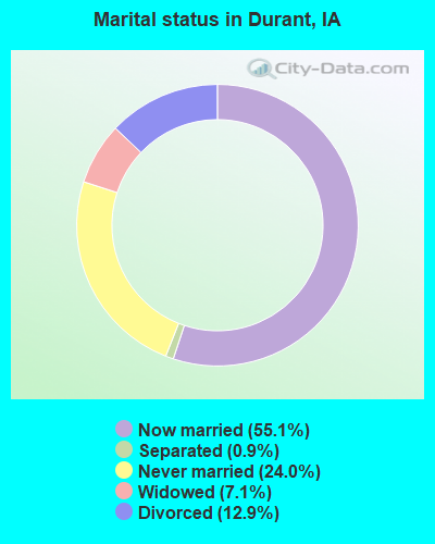
- Never married: 24.0%
- Now married: 55.1%
- Separated: 0.9%
- Widowed: 7.1%
- Divorced: 12.9%
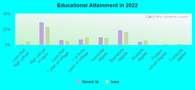
For population 25 years and over in Durant:
- High school or higher: 97.9%
- Bachelor's degree or higher: 29.1%
- Graduate or professional degree: 6.9%
- Unemployed: 2.0%
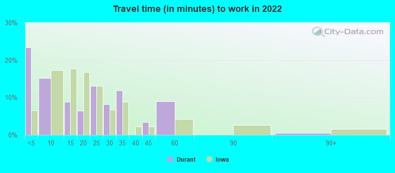
- Mean travel time to work (commute): 20.0 minutes
| Here: | 8.5 |
| Iowa average: | 10.5 |
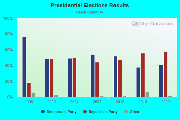
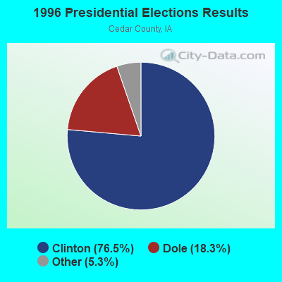
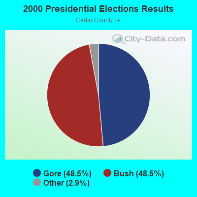
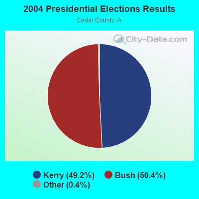
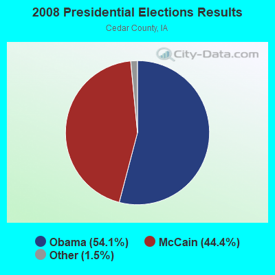
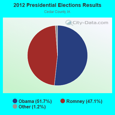
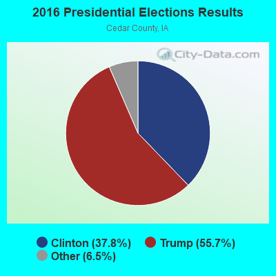
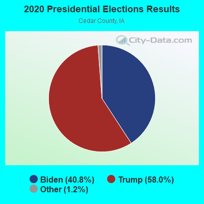
Graphs represent county-level data. Detailed 2008 Election Results
Religion statistics for Durant, IA (based on Cedar County data)
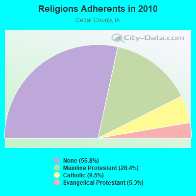
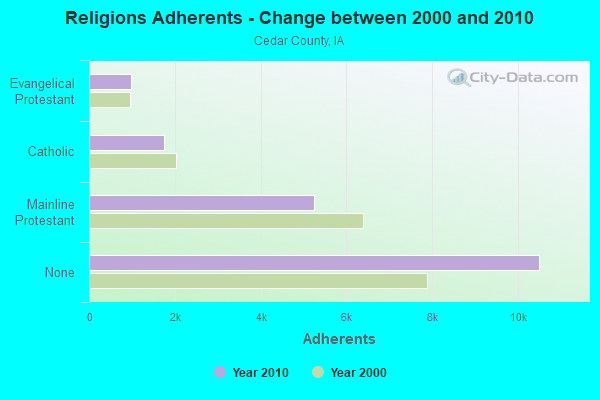
| Religion | Adherents | Congregations |
|---|---|---|
| Mainline Protestant | 5,250 | 19 |
| Catholic | 1,759 | 3 |
| Evangelical Protestant | 987 | 10 |
| Other | 4 | - |
| None | 10,499 | - |
Food Environment Statistics:
| Cedar County: | 3.34 / 10,000 pop. |
| State: | 2.14 / 10,000 pop. |
| This county: | 0.56 / 10,000 pop. |
| State: | 0.43 / 10,000 pop. |
| This county: | 7.24 / 10,000 pop. |
| Iowa: | 5.55 / 10,000 pop. |
| This county: | 7.79 / 10,000 pop. |
| Iowa: | 8.01 / 10,000 pop. |
| This county: | 7.6% |
| Iowa: | 7.8% |
| This county: | 27.6% |
| State: | 27.3% |
| Cedar County: | 7.2% |
| Iowa: | 14.5% |
Health and Nutrition:
| Durant: | 55.2% |
| State: | 49.5% |
| Here: | 53.1% |
| Iowa: | 46.1% |
| Durant: | 27.3 |
| Iowa: | 28.6 |
| Here: | 17.6% |
| State: | 21.4% |
| Durant: | 7.6% |
| State: | 10.4% |
| Here: | 7.1 |
| Iowa: | 6.8 |
| Durant: | 31.2% |
| Iowa: | 33.8% |
| Durant: | 61.0% |
| Iowa: | 55.9% |
| Durant: | 79.4% |
| Iowa: | 77.7% |
More about Health and Nutrition of Durant, IA Residents
| Local government employment and payroll (March 2022) | |||||
| Function | Full-time employees | Monthly full-time payroll | Average yearly full-time wage | Part-time employees | Monthly part-time payroll |
|---|---|---|---|---|---|
| Electric Power | 5 | $32,279 | $77,470 | 0 | $0 |
| Police Protection - Officers | 4 | $21,273 | $63,819 | 1 | $1,050 |
| Sewerage | 2 | $9,960 | $59,760 | 0 | $0 |
| Financial Administration | 2 | $8,917 | $53,502 | 0 | $0 |
| Water Supply | 1 | $5,519 | $66,228 | 0 | $0 |
| Streets and Highways | 1 | $4,689 | $56,268 | 0 | $0 |
| Other and Unallocable | 0 | $0 | 1 | $548 | |
| Parks and Recreation | 0 | $0 | 3 | $2,316 | |
| Totals for Government | 15 | $82,639 | $66,111 | 5 | $3,914 |
Durant government finances - Expenditure in 2017 (per resident):
- Construction - Sewerage: $752,000 ($406.49)
Water Utilities: $105,000 ($56.76)
- Current Operations - Regular Highways: $2,376,000 ($1284.32)
Electric Utilities: $1,748,000 ($944.86)
Sewerage: $320,000 ($172.97)
Police Protection: $303,000 ($163.78)
Water Utilities: $229,000 ($123.78)
Parks and Recreation: $159,000 ($85.95)
Solid Waste Management: $153,000 ($82.70)
General - Other: $151,000 ($81.62)
Local Fire Protection: $131,000 ($70.81)
General Public Buildings: $123,000 ($66.49)
Central Staff Services: $90,000 ($48.65)
Libraries: $70,000 ($37.84)
Financial Administration: $63,000 ($34.05)
Health - Other: $35,000 ($18.92)
Judicial and Legal Services: $29,000 ($15.68)
Protective Inspection and Regulation - Other: $16,000 ($8.65)
Miscellaneous Commercial Activities - Other: $3,000 ($1.62)
- Electric Utilities - Interest on Debt: $26,000 ($14.05)
- General - Interest on Debt: $437,000 ($236.22)
- Intergovernmental to Local - Other - Electric Utilities: $124,000 ($67.03)
Other - Libraries: $63,000 ($34.05)
- Total Salaries and Wages: $886,000 ($478.92)
- Water Utilities - Interest on Debt: $8,000 ($4.32)
Durant government finances - Revenue in 2017 (per resident):
- Charges - Sewerage: $583,000 ($315.14)
Solid Waste Management: $151,000 ($81.62)
- Local Intergovernmental - Other: $70,000 ($37.84)
- Miscellaneous - Sale of Property: $85,000 ($45.95)
Interest Earnings: $24,000 ($12.97)
General Revenue - Other: $20,000 ($10.81)
Rents: $20,000 ($10.81)
Special Assessments: $12,000 ($6.49)
Fines and Forfeits: $1,000 ($0.54)
- Revenue - Electric Utilities: $1,985,000 ($1072.97)
Water Utilities: $299,000 ($161.62)
- State Intergovernmental - Highways: $227,000 ($122.70)
General Local Government Support: $60,000 ($32.43)
Other: $29,000 ($15.68)
- Tax - Property: $1,214,000 ($656.22)
General Sales and Gross Receipts: $164,000 ($88.65)
Other License: $85,000 ($45.95)
Public Utilities Sales: $4,000 ($2.16)
Durant government finances - Debt in 2017 (per resident):
- Long Term Debt - Beginning Outstanding - Unspecified Public Purpose: $11,766,000 ($6360.00)
Outstanding Unspecified Public Purpose: $10,972,000 ($5930.81)
Retired Unspecified Public Purpose: $794,000 ($429.19)
Durant government finances - Cash and Securities in 2017 (per resident):
- Other Funds - Cash and Securities: $5,499,000 ($2972.43)
Businesses in Durant, IA
- Ford: 1
- MasterBrand Cabinets: 1
- Subway: 1
Strongest AM radio stations in Durant:
- WOC (1420 AM; 5 kW; DAVENPORT, IA; Owner: CITICASTERS LICENSES, L.P.)
- WKBF (1270 AM; 5 kW; ROCK ISLAND, IL; Owner: MERCURY BROADCASTING COMPANY, INC.)
- KCJJ (1630 AM; 10 kW; IOWA CITY, IA; Owner: RIVER CITY RADIO, INC.)
- WSUI (910 AM; 5 kW; IOWA CITY, IA; Owner: THE UNIVERSITY OF IOWA)
- KXEL (1540 AM; 50 kW; WATERLOO, IA; Owner: KXEL BROADCASTING COMPANY, INC.)
- WMT (600 AM; 5 kW; CEDAR RAPIDS, IA; Owner: CITICASTERS LICENSES, L.P.)
- WSCR (670 AM; 50 kW; CHICAGO, IL; Owner: INFINITY BROADCASTING OPERATIONS, INC.)
- WHO (1040 AM; 50 kW; DES MOINES, IA; Owner: CITICASTERS LICENSES, L.P.)
- WGN (720 AM; 50 kW; CHICAGO, IL; Owner: WGN CONTINENTAL BROADCASTING CO.)
- WTMJ (620 AM; 50 kW; MILWAUKEE, WI; Owner: JOURNAL BROADCAST CORPORATION)
- WBBM (780 AM; 50 kW; CHICAGO, IL; Owner: INFINITY BROADCASTING OPERATIONS, INC.)
- WLS (890 AM; 50 kW; CHICAGO, IL; Owner: WLS, INC.)
- WMVP (1000 AM; 50 kW; CHICAGO, IL; Owner: ABC, INC.)
Strongest FM radio stations in Durant:
- KBEA-FM (99.7 FM; MUSCATINE, IA; Owner: CUMULUS LICENSING CORP.)
- KSUI (91.7 FM; IOWA CITY, IA; Owner: THE UNIVERSITY OF IOWA)
- WLLR-FM (103.7 FM; DAVENPORT, IA; Owner: CITICASTERS LICENSES, L.P.)
- WVIK (90.3 FM; ROCK ISLAND, IL; Owner: AUGUSTANA COLLEGE)
- KCQQ (106.5 FM; DAVENPORT, IA; Owner: CITICASTERS LICENSES, L.P.)
- KMXG (96.1 FM; CLINTON, IA; Owner: CITICASTERS LICENSES, L.P.)
- KWCC (93.1 FM; MUSCATINE, IA; Owner: WPW BROADCASTING, INC.)
- KUUL (101.3 FM; EAST MOLINE, IL; Owner: CITICASTERS LICENSES, L.P.)
- WHTS (98.9 FM; ROCK ISLAND, IL; Owner: MERCURY BROADCASTING COMPANY, INC.)
- KBOB-FM (104.9 FM; GENESEO, IL; Owner: CUMULUS LICENSING CORP.)
- WDLM-FM (89.3 FM; EAST MOLINE, IL; Owner: THE MOODY BIBLE INSTITUTE OF CHICAGO)
TV broadcast stations around Durant:
- K16EL (Channel 66; DAVENPORT, IA; Owner: THREE ANGELS BROADCASTING NETWORK)
- KIIN (Channel 12; IOWA CITY, IA; Owner: IOWA PUBLIC BROADCASTING BOARD)
- KWKB (Channel 20; IOWA CITY, IA; Owner: KM TELEVISION OF IOWA, L.L.C.)
- WHBF-TV (Channel 4; ROCK ISLAND, IL; Owner: CORONET COMMUNICATIONS COMPANY)
- WBQD-LP (Channel 26; DAVENPORT, IA; Owner: FOUR SEASONS PEORIA, LLC)
- KWQC-TV (Channel 6; DAVENPORT, IA; Owner: YOUNG BROADCASTING OF DAVENPORT, INC.)
- KLJB-TV (Channel 18; DAVENPORT, IA; Owner: QUAD CITIES TELEVISION ACQUISITION CORP.)
- K62FU (Channel 62; MUSCATINE, IA; Owner: TRINITY BROADCASTING NETWORK)
- WQAD-TV (Channel 8; MOLINE, IL; Owner: NEW YORK TIMES MANAGEMENT SERVICES)
- K61HD (Channel 61; DAVENPORT, IA; Owner: TRINITY BROADCASTING NETWORK)
- KFXA (Channel 28; CEDAR RAPIDS, IA; Owner: SECOND GENERATION OF IOWA, LTD.)
- KQIN (Channel 36; DAVENPORT, IA; Owner: IOWA PUBLIC BROADCASTING BOARD)
- WQPT-TV (Channel 24; MOLINE, IL; Owner: BLACK HAWK COLLEGE)
Durant fatal accident list:
- National Bridge Inventory (NBI) Statistics
- 25Number of bridges
- 197ft / 60.0mTotal length
- 133,425Total average daily traffic
- 51,774Total average daily truck traffic
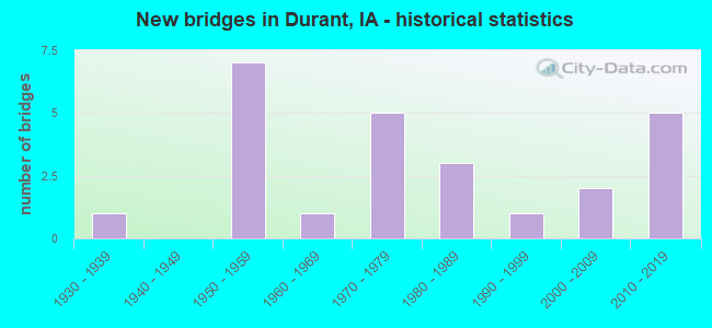
- New bridges - historical statistics
- 11930-1939
- 71950-1959
- 11960-1969
- 51970-1979
- 31980-1989
- 11990-1999
- 22000-2009
- 52010-2019
FCC Registered Cell Phone Towers:
1 (See the full list of FCC Registered Cell Phone Towers in Durant)FCC Registered Antenna Towers:
13 (See the full list of FCC Registered Antenna Towers)FCC Registered Broadcast Land Mobile Towers:
7- Lat: 41.618889 Lon: -90.923194, Call Sign: WNCG721,
Assigned Frequencies: 463.262 MHz, Grant Date: 06/02/2015, Expiration Date: 05/17/2025, Registrant: Business Radio, 1418 5th Street, Coralville, IA 52241, Phone: (319) 354-2204, Fax: (319) 351-2938, Email:
- Rr 1 1 Mi S Of Durant On Cr (Lat: 41.579722 Lon: -91.914889), Call Sign: WZM223, Licensee ID: L00030919,
Assigned Frequencies: 153.005 MHz, Grant Date: 02/26/2014, Expiration Date: 05/10/2024, Registrant: Treimer Industries Inc, 3277 102nd St, Durant, IA 52747, Phone: (563) 785-4427, Fax: (563) 785-4428, Email:
- Lat: 41.603361 Lon: -90.913333, Call Sign: WQLQ962,
Assigned Frequencies: 159.937 MHz, 160.072 MHz, 160.192 MHz, Grant Date: 03/07/2020, Expiration Date: 04/05/2030, Certifier: Ryan Blahosky, Registrant: Federal License Management, 175 Pine St, Suite 104, Williamsport, PA 17701-6549, Phone: (866) 908-2220, Fax: (570) 323-4002, Email:
- Lat: 41.572722 Lon: -90.892861, Call Sign: WQRG722,
Assigned Frequencies: 159.870 MHz, Grant Date: 05/09/2013, Expiration Date: 05/09/2023, Cancellation Date: 07/15/2023, Certifier: Brian Schlapkohl, Registrant: Midwest Wireless, 5915 Brady Street, Davenport, IA 52806, Phone: (563) 386-7344, Fax: (563) 386-9011, Email:
- Lat: 41.641667 Lon: -90.899444, Call Sign: WQTS404,
Assigned Frequencies: 452.075 MHz, Grant Date: 04/02/2014, Expiration Date: 04/02/2024, Certifier: Loren Keppy, Registrant: Midwest Wireless, 5915 N Brady Street, Davenport, IA 52806, Phone: (563) 386-7344, Fax: (563) 386-9011, Email:
- Lat: 41.609861 Lon: -90.950611, Call Sign: WQVF559,
Assigned Frequencies: 151.857 MHz, Grant Date: 01/27/2015, Expiration Date: 01/27/2025, Certifier: Tom Fitzer, Registrant: Communication Engineering Co., 405 Boyson Rd, Hiawatha, IA 52233, Phone: (319) 731-1275, Fax: (319) 395-6096, Email:
- 220th Street (Lat: 41.625917 Lon: -90.805944), Type: Ltower, Structure height: 79.2 m, Overall height: 82.3 m, Call Sign: WRNC911,
Assigned Frequencies: 769.356 MHz, 769.843 MHz, 770.781 MHz, 771.393 MHz, Grant Date: 07/16/2021, Expiration Date: 07/16/2031, Certifier: David Donovan, Registrant: Racom Corp., 201 W. State St., Marshalltown, IA 50158, Phone: (888) 752-1016, Email:
FCC Registered Microwave Towers:
10 (See the full list of FCC Registered Microwave Towers in this town)FCC Registered Amateur Radio Licenses:
4- Call Sign: KD6SXA, Licensee ID: L00269096, Grant Date: 01/15/2013, Expiration Date: 02/23/2023, Cancellation Date: 06/16/2015, Certifier: Arnold J Alt Iii, Registrant: Arnold J Alt Iii, 607 15th Ave, Durant, IA 52747
- Call Sign: K0BDU, Previous Call Sign: KD0BDU, Licensee ID: L01160080, Grant Date: 02/12/2019, Expiration Date: 03/03/2029, Certifier: Casey A Jones, Registrant: Casey A Jones, 1109 6th St., Durant, IA 52747
- Call Sign: KE0IMC, Licensee ID: L02013986, Grant Date: 04/05/2016, Expiration Date: 04/05/2026, Certifier: John H Alt, Registrant: John H Alt, 607 15th Ave, Durant, IA 52747
- Call Sign: KF0OAC, Licensee ID: L02718291, Grant Date: 10/26/2023, Expiration Date: 10/26/2033, Certifier: Adam M Sterner, Registrant: Adam M Sterner, 1208 3rd St, Durant, IA 52747-9780
FAA Registered Aircraft:
3- Aircraft: TODD S FUSCO FUSCO BARRACUDA (Category: Land, Seats: 2, Weight: Up to 12,499 Pounds), Engine: Reciprocating
N-Number: 514TF, N514TF, N-514TF, Serial Number: 001, Certificate Issue Date: 10/12/2018
Registrant (Individual): Todd S Fusco, 606 7th Ave, Durant, IA 52747 - Aircraft: PIPER PA-28-140 (Category: Land, Seats: 4, Weight: Up to 12,499 Pounds, Speed: 107 mph), Engine: LYCOMING 0-320 SERIES (180 HP) (Reciprocating)
N-Number: 6676W, N6676W, N-6676W, Serial Number: 28-20783, Year manufactured: 1965, Airworthiness Date: 03/15/1965, Certificate Issue Date: 08/03/1987
Registrant (Corporation): Workman Industries Inc, 21705 20th Ave, Durant, IA 52747 - Aircraft: CIRRUS DESIGN CORP SR22T (Category: Land, Seats: 5, Weight: Up to 12,499 Pounds), Engine: CONT MOTOR TSIO-550-K (315 HP) (Reciprocating)
N-Number: 811EA, N811EA, N-811EA, Serial Number: 1265, Year manufactured: 2016, Airworthiness Date: 02/29/2016, Certificate Issue Date: 04/25/2017
Registrant (LLC): C B M Aviation LLC, 1314 Vail Ave, Durant, IA 52747
2002 - 2017 National Fire Incident Reporting System (NFIRS) incidents
- Fire incident types reported to NFIRS in Durant, IA
- 7853.8%Outside Fires
- 3121.4%Mobile Property/Vehicle Fires
- 2819.3%Structure Fires
- 85.5%Other
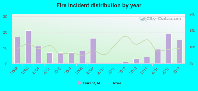 Based on the data from the years 2002 - 2017 the average number of fires per year is 9. The highest number of fires - 21 took place in 2003, and the least - 0 in 2010. The data has a decreasing trend.
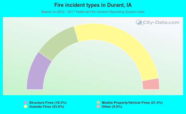 When looking into fire subcategories, the most incidents belonged to: Outside Fires (53.8%), and Mobile Property/Vehicle Fires (21.4%).
| Most common first names in Durant, IA among deceased individuals | ||
| Name | Count | Lived (average) |
|---|---|---|
| John | 20 | 73.6 years |
| William | 19 | 80.5 years |
| Henry | 13 | 80.0 years |
| Walter | 12 | 86.3 years |
| Arthur | 11 | 74.1 years |
| Raymond | 10 | 80.1 years |
| Leroy | 10 | 73.5 years |
| Dorothy | 10 | 80.3 years |
| Robert | 10 | 68.1 years |
| Ella | 9 | 84.6 years |
| Most common last names in Durant, IA among deceased individuals | ||
| Last name | Count | Lived (average) |
|---|---|---|
| Schlapkohl | 10 | 82.6 years |
| Wulf | 10 | 80.0 years |
| Paustian | 10 | 84.2 years |
| Moeller | 9 | 72.8 years |
| Finck | 9 | 72.8 years |
| Otto | 8 | 78.1 years |
| Petersen | 7 | 80.4 years |
| Krebs | 7 | 79.4 years |
| Bockwoldt | 7 | 82.0 years |
| Hamann | 7 | 83.5 years |
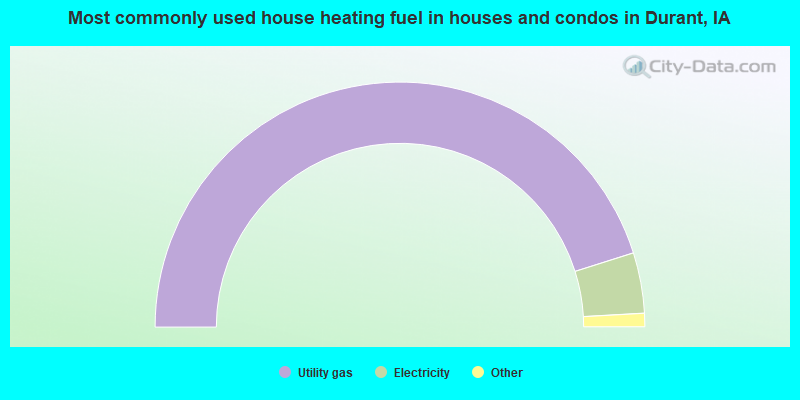
- 90.4%Utility gas
- 8.0%Electricity
- 0.5%Bottled, tank, or LP gas
- 0.5%Fuel oil, kerosene, etc.
- 0.5%Other fuel
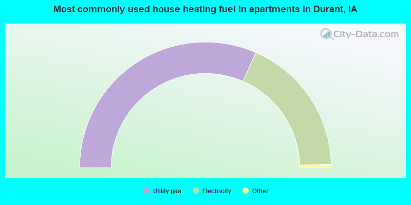
- 63.6%Utility gas
- 36.4%Electricity
Durant compared to Iowa state average:
- Unemployed percentage significantly below state average.
- Black race population percentage significantly below state average.
- Hispanic race population percentage below state average.
- Median age below state average.
- Foreign-born population percentage significantly below state average.
- Length of stay since moving in above state average.

|
Total of 14 patent applications in 2008-2024.