East Mayes, Oklahoma
Submit your own pictures of this place and show them to the world
- OSM Map
- General Map
- Google Map
- MSN Map

| Males: 4,042 | |
| Females: 4,065 |
| Median resident age: | 39.9 years |
| Oklahoma median age: | 35.5 years |
Zip code: 74366
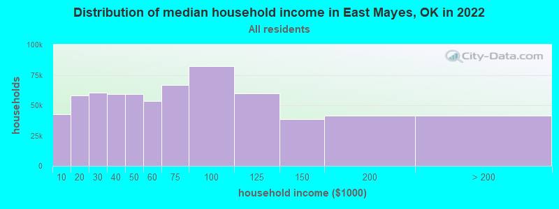
| East Mayes: | $49,739 |
| OK: | $59,673 |
Estimated per capita income in 2022: $27,997 (it was $14,824 in 2000)
East Mayes CCD income, earnings, and wages data
Estimated median house or condo value in 2022: $150,134 (it was $55,500 in 2000)
| East Mayes: | $150,134 |
| OK: | $191,700 |
Detailed information about poverty and poor residents in East Mayes, OK


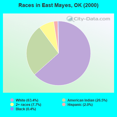
- 4,96463.4%White alone
- 2,07426.5%American Indian alone
- 6037.7%Two or more races
- 1532.0%Hispanic
- 300.4%Black alone
- 70.09%Asian alone
- 40.05%Other race alone
Races in East Mayes detailed stats: ancestries, foreign born residents, place of birth
 Recent articles from our blog. Our writers, many of them Ph.D. graduates or candidates, create easy-to-read articles on a wide variety of topics.
Current Local Time: CST time zone
Land area: 116.3 square miles.
Population density: 70 people per square mile (very low).

| East Mayes CCD: | 0.6% ($306) |
| Oklahoma: | 0.8% ($523) |
Nearest city with pop. 50,000+: Broken Arrow, OK  (47.2 miles , pop. 74,859).
Nearest city with pop. 200,000+: Tulsa, OK (51.8 miles , pop. 393,049).
Nearest city with pop. 1,000,000+: Dallas, TX (268.2 miles , pop. 1,188,580).
Nearest cities:
), Latitude: 36.41 N, Longitude: 95.08 W
Area code commonly used in this area: 918

| Here: | 3.1% |
| Oklahoma: | 3.2% |
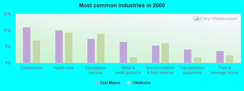
- Construction (11.0%)
- Health care (10.1%)
- Educational services (7.5%)
- Metal & metal products (6.5%)
- Accommodation & food services (5.4%)
- Transportation equipment (4.2%)
- Food & beverage stores (3.7%)
- Construction (19.2%)
- Metal & metal products (10.6%)
- Utilities (5.4%)
- Transportation equipment (4.1%)
- Machinery (3.8%)
- Agriculture, forestry, fishing & hunting (3.0%)
- Motor vehicle & parts dealers (3.0%)
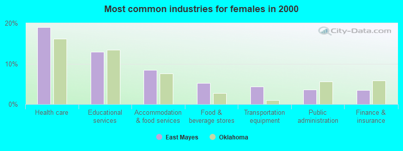
- Health care (19.0%)
- Educational services (12.9%)
- Accommodation & food services (8.5%)
- Food & beverage stores (5.3%)
- Transportation equipment (4.3%)
- Public administration (3.6%)
- Finance & insurance (3.4%)
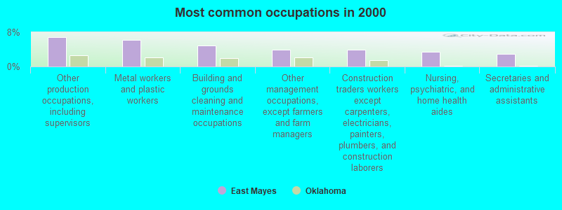
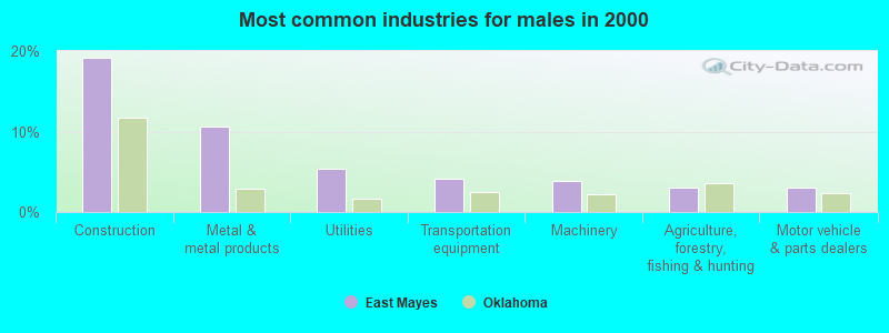
- Other production occupations, including supervisors (6.8%)
- Metal workers and plastic workers (6.2%)
- Building and grounds cleaning and maintenance occupations (4.9%)
- Other management occupations, except farmers and farm managers (3.9%)
- Construction traders workers except carpenters, electricians, painters, plumbers, and construction laborers (3.9%)
- Nursing, psychiatric, and home health aides (3.4%)
- Secretaries and administrative assistants (3.0%)
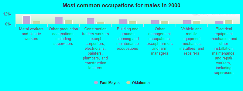
- Metal workers and plastic workers (10.3%)
- Other production occupations, including supervisors (8.7%)
- Construction traders workers except carpenters, electricians, painters, plumbers, and construction laborers (7.2%)
- Building and grounds cleaning and maintenance occupations (5.7%)
- Other management occupations, except farmers and farm managers (5.2%)
- Vehicle and mobile equipment mechanics, installers, and repairers (4.8%)
- Electrical equipment mechanics and other installation, maintenance, and repair workers, including supervisors (4.2%)

- Nursing, psychiatric, and home health aides (7.3%)
- Secretaries and administrative assistants (6.5%)
- Cashiers (4.7%)
- Other production occupations, including supervisors (4.6%)
- Preschool, kindergarten, elementary, and middle school teachers (4.1%)
- Building and grounds cleaning and maintenance occupations (4.1%)
- Retail sales workers, except cashiers (3.6%)
Average climate in East Mayes, Oklahoma
Based on data reported by over 4,000 weather stations


(lower is better)
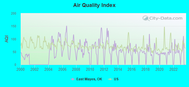
Air Quality Index (AQI) level in 2022 was 52.5. This is better than average.
| City: | 52.5 |
| U.S.: | 72.6 |
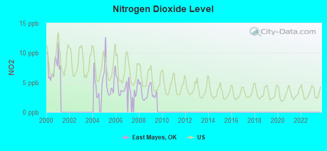
Nitrogen Dioxide (NO2) [ppb] level in 2009 was 3.29. This is significantly better than average. Closest monitor was 13.8 miles away from the city center.
| City: | 3.29 |
| U.S.: | 5.11 |
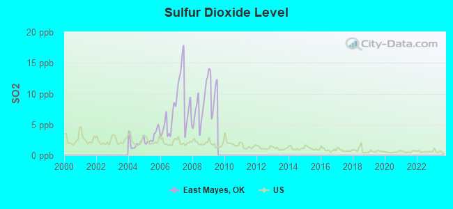
Sulfur Dioxide (SO2) [ppb] level in 2009 was 10.5. This is significantly worse than average. Closest monitor was 16.0 miles away from the city center.
| City: | 10.5 |
| U.S.: | 1.5 |
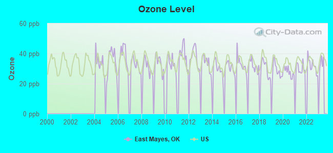
Ozone [ppb] level in 2022 was 32.1. This is about average. Closest monitor was 16.0 miles away from the city center.
| City: | 32.1 |
| U.S.: | 33.3 |
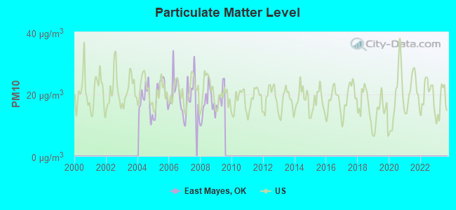
Particulate Matter (PM10) [µg/m3] level in 2009 was 19.4. This is about average. Closest monitor was 13.8 miles away from the city center.
| City: | 19.4 |
| U.S.: | 19.2 |
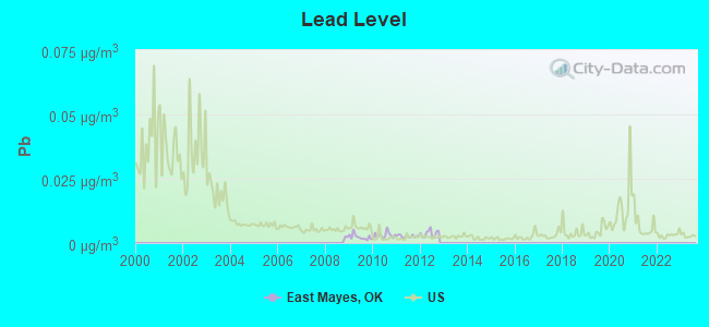
Lead (Pb) [µg/m3] level in 2012 was 0.00370. This is significantly better than average. Closest monitor was 15.1 miles away from the city center.
| City: | 0.00370 |
| U.S.: | 0.00931 |
Tornado activity:
East Mayes-area historical tornado activity is near Oklahoma state average. It is 145% greater than the overall U.S. average.
On 4/3/1956, a category F4 (max. wind speeds 207-260 mph) tornado 25.4 miles away from the East Mayes place center injured 59 people and caused between $500,000 and $5,000,000 in damages.
On 5/9/1959, a category F3 (max. wind speeds 158-206 mph) tornado 2.7 miles away from the place center injured 3 people and caused between $50,000 and $500,000 in damages.
Earthquake activity:
East Mayes-area historical earthquake activity is significantly above Oklahoma state average. It is 718% greater than the overall U.S. average.On 9/3/2016 at 12:02:44, a magnitude 5.8 (5.8 MW, Depth: 3.5 mi, Class: Moderate, Intensity: VI - VII) earthquake occurred 103.1 miles away from East Mayes center
On 11/6/2011 at 03:53:10, a magnitude 5.7 (5.7 MW, Depth: 3.2 mi) earthquake occurred 112.4 miles away from East Mayes center
On 11/7/2016 at 01:44:24, a magnitude 5.0 (5.0 MW, Depth: 2.8 mi) earthquake occurred 100.6 miles away from East Mayes center
On 11/5/2011 at 07:12:45, a magnitude 4.8 (4.8 MW, Depth: 1.9 mi, Class: Light, Intensity: IV - V) earthquake occurred 111.7 miles away from the city center
On 11/8/2011 at 02:46:57, a magnitude 4.8 (4.8 MW, Depth: 3.1 mi) earthquake occurred 113.5 miles away from the city center
On 11/12/2014 at 21:40:00, a magnitude 4.9 (4.9 MW, Depth: 2.5 mi) earthquake occurred 152.8 miles away from East Mayes center
Magnitude types: moment magnitude (MW)
Natural disasters:
The number of natural disasters in Mayes County (26) is a lot greater than the US average (15).Major Disasters (Presidential) Declared: 17
Emergencies Declared: 5
Causes of natural disasters: Floods: 12, Storms: 11, Winter Storms: 11, Tornadoes: 9, Fires: 2, Winds: 2, Hurricane: 1, Snowstorm: 1, Other: 1 (Note: some incidents may be assigned to more than one category).
Hospitals and medical centers near East Mayes:
- PARKHILL NORTH NURSING HOME (Nursing Home, about 10 miles away; SALINA, OK)
- COLONIAL TERRACE CARE CENTER (Nursing Home, about 15 miles away; PRYOR, OK)
- GRAND VALLEY CARE CTR INC (Nursing Home, about 15 miles away; PRYOR, OK)
- INTEGRIS MAYES COUNTY MEDICAL CENTER Acute Care Hospitals (about 15 miles away; PRYOR, OK)
- MOOTS OSTEOPATHIC HOSPITAL (Hospital, about 16 miles away; PRYOR, OK)
- DVA RENAL HEALTHCARE - PRYOR (Dialysis Facility, about 16 miles away; PRYOR, OK)
- SHADY REST CARE CENTER (Nursing Home, about 16 miles away; PRYOR, OK)
Colleges/universities with over 2000 students nearest to East Mayes:
- Rogers State University (about 32 miles; Claremore, OK; Full-time enrollment: 3,482)
- John Brown University (about 33 miles; Siloam Springs, AR; FT enrollment: 2,097)
- Northeastern Oklahoma A&M College (about 35 miles; Miami, OK; FT enrollment: 2,075)
- Northeastern State University (about 35 miles; Tahlequah, OK; FT enrollment: 6,895)
- Crowder College (about 49 miles; Neosho, MO; FT enrollment: 3,675)
- NorthWest Arkansas Community College (about 51 miles; Bentonville, AR; FT enrollment: 5,634)
- Tulsa Community College (about 51 miles; Tulsa, OK; FT enrollment: 12,480)
Points of interest:
Notable locations in East Mayes: City of Vinita Water Intake (A), Cabin Creek Fire Department (B), Spavinaw Fire Department (C), Langley Fire Department (D), Salina Fire Department (E), Strang Fire Department (F), Disney Fire Department (G). Display/hide their locations on the map
Churches in East Mayes include: Blue Springs Church (A), Ribbon Church (B), New Jordan Church (C), Standing Rock Church (D), Military Church (E). Display/hide their locations on the map
Cemeteries: West Cemetery (1), Wickliffe Cemetery (2), Grass Cemetery (3), Military Cemetery (4), Ross Mayes Cemetery (5), Spavinaw Cemetery (6). Display/hide their locations on the map
Reservoirs: Lake O the Cherokees (A), Spavinaw Lake (B). Display/hide their locations on the map
Creeks: Wickliffe Creek (A), Big Cabin Creek (B), Summerfield Creek (C), Spavinaw Creek (D), Saline Creek (E), Mustang Creek (F), Elm Creek (G). Display/hide their locations on the map
Parks in East Mayes include: Recreation Area Number 3 (1), Recreation Area Number 2 (2), Recreation Area Number 1 (3), Spavinaw State Park (4), Cherokee State Park (5), Salina State Park (6). Display/hide their locations on the map
| This place: | 2.5 people |
| Oklahoma: | 2.5 people |
| This place: | 67.8% |
| Whole state: | 66.8% |
| This place: | 6.6% |
| Whole state: | 5.9% |
Likely homosexual households (counted as self-reported same-sex unmarried-partner households)
- Lesbian couples: 0.3% of all households
- Gay men: 0.4% of all households
| This place: | 19.3% |
| Whole state: | 14.7% |
| This place: | 6.9% |
| Whole state: | 6.1% |
People in group quarters in East Mayes in 2010:
- 127 people in group homes intended for adults
- 58 people in nursing facilities/skilled-nursing facilities
- 8 people in emergency and transitional shelters (with sleeping facilities) for people experiencing homelessness
People in group quarters in East Mayes in 2000:
- 66 people in mental (psychiatric) hospitals or wards
- 64 people in nursing homes
- 24 people in other group homes
- 21 people in other noninstitutional group quarters
For population 15 years and over in East Mayes:
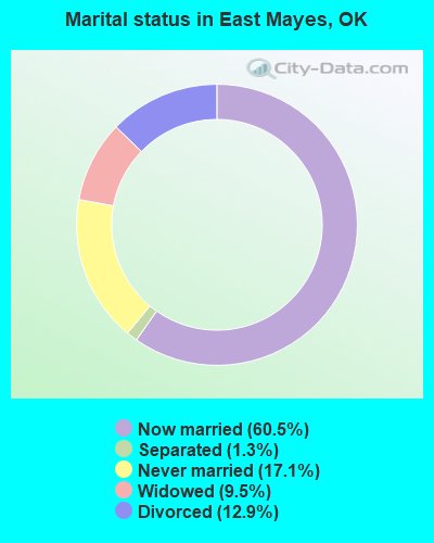
- Never married: 17.1%
- Now married: 60.5%
- Separated: 1.3%
- Widowed: 9.5%
- Divorced: 12.9%
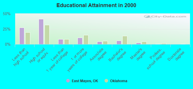
For population 25 years and over in East Mayes:
- High school or higher: 72.9%
- Bachelor's degree or higher: 8.7%
- Graduate or professional degree: 3.1%
- Unemployed: 5.6%
- Mean travel time to work (commute): 27.8 minutes
| Here: | 10.1 |
| Oklahoma average: | 11.7 |
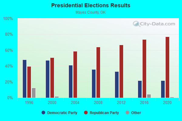
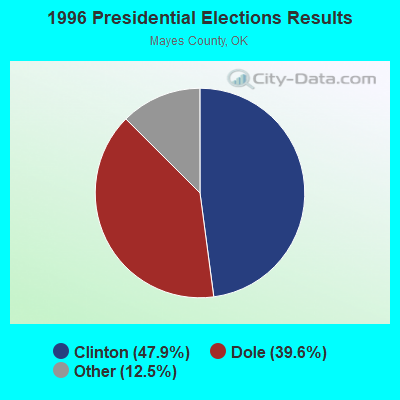
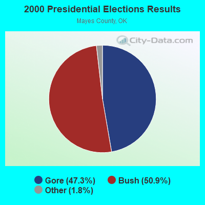
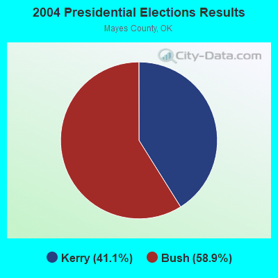
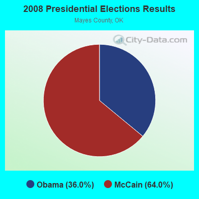
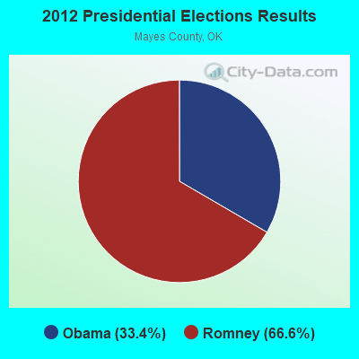
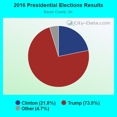
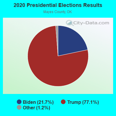
Graphs represent county-level data. Detailed 2008 Election Results
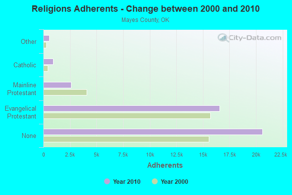
Religion statistics for East Mayes, OK (based on Mayes County data)
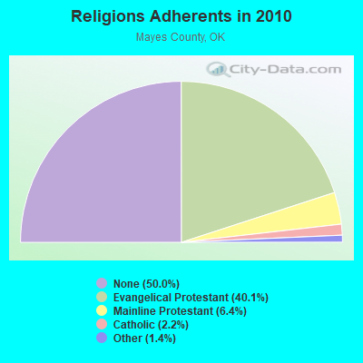
| Religion | Adherents | Congregations |
|---|---|---|
| Evangelical Protestant | 16,552 | 100 |
| Mainline Protestant | 2,623 | 12 |
| Catholic | 900 | 2 |
| Other | 571 | 3 |
| None | 20,613 | - |
Food Environment Statistics:
| This county: | 3.03 / 10,000 pop. |
| Oklahoma: | 1.97 / 10,000 pop. |
| This county: | 0.51 / 10,000 pop. |
| State: | 0.76 / 10,000 pop. |
| Mayes County: | 5.81 / 10,000 pop. |
| Oklahoma: | 4.35 / 10,000 pop. |
| Here: | 7.33 / 10,000 pop. |
| Oklahoma: | 6.89 / 10,000 pop. |
| This county: | 11.6% |
| Oklahoma: | 10.3% |
| Here: | 31.9% |
| Oklahoma: | 29.2% |
Strongest AM radio stations in East Mayes:
- KFAQ (1170 AM; 50 kW; TULSA, OK; Owner: JOURNAL BROADCAST CORPORATION)
- KRMG (740 AM; 50 kW; TULSA, OK; Owner: CXR HOLDINGS, INC.)
- KTBZ (1430 AM; 25 kW; TULSA, OK; Owner: CLEAR CHANNEL BROADCASTING LICENSES, INC.)
- KMUS (1380 AM; 20 kW; MUSKOGEE, OK; Owner: ABC, INC.)
- KGGF (690 AM; 10 kW; COFFEYVILLE, KS; Owner: KGGF-KUSN, INC.)
- KUOA (1290 AM; 5 kW; SILOAM SPRINGS, AR; Owner: KUOA, INC.)
- KFAY (1030 AM; 10 kW; FARMINGTON, AR; Owner: CUMULUS LICENSING CORP)
- KBTN (1420 AM; 10 kW; NEOSHO, MO; Owner: PETRACOM OF JOPLIN, L.L.C.)
- KMUR (1570 AM; 1 kW; PRYOR, OK)
- KXTD (1530 AM; daytime; 5 kW; WAGONER, OK; Owner: GAYTAN-GALVAN LIMITED LIABILITY COMP)
- WMBH (1560 AM; 10 kW; JOPLIN, MO)
- KKOW (860 AM; 10 kW; PITTSBURG, KS; Owner: AMERICAN MEDIA INVESTMENTS)
- KURM (790 AM; 5 kW; ROGERS, AR; Owner: KERM, INC)
Strongest FM radio stations in East Mayes:
- KGND (107.5 FM; KETCHUM, OK; Owner: NORTHEAST OKLAHOMA BROADCAST NETWORK)
- KITO-FM (96.1 FM; VINITA, OK; Owner: DLB BROADCASTING CORPORATION)
- KQLL-FM (106.1 FM; OWASSO, OK; Owner: CLEAR CHANNEL BROADCASTING LICENSES, INC.)
- KEMX (94.5 FM; LOCUST GROVE, OK; Owner: KXOJ, INC.)
- KNYD (90.5 FM; BROKEN ARROW, OK; Owner: CREATIVE EDUCATIONAL MEDIA CORP. INC)
- KJSR (103.3 FM; TULSA, OK; Owner: CXR HOLDINGS, INC.)
- KMYZ-FM (104.5 FM; PRYOR, OK; Owner: SHAMROCK COMMUNICATIONS, INC.)
- KURM-FM (100.3 FM; SOUTHWEST CITY, MO; Owner: KERM, INC.)
- KWGS (89.5 FM; TULSA, OK; Owner: THE UNIVERSITY OF TULSA)
- KGVE (99.3 FM; GROVE, OK; Owner: CALEB CORPORATION)
- KTFR (100.7 FM; CHELSEA, OK; Owner: MICHAEL P. STEPHENS)
TV broadcast stations around East Mayes:
- KJRH (Channel 2; TULSA, OK; Owner: SCRIPPS HOWARD BROADCASTING COMPANY)
- KOED-TV (Channel 11; TULSA, OK; Owner: OKLAHOMA EDUCATIONAL TELEVISION AUTHORITY)
- KTUL (Channel 8; TULSA, OK; Owner: KTUL, LLC)
- KOTV (Channel 6; TULSA, OK; Owner: GRIFFIN LICENSING, L.L.C.)
- KTFO (Channel 41; TULSA, OK; Owner: CLEAR CHANNEL BROADCASTING LICENSES, INC.)
- KRSC-TV (Channel 35; CLAREMORE, OK; Owner: BOARD OF REGENTS OF OKLAHOMA COLLEGES)
- KWHB (Channel 47; TULSA, OK; Owner: LESEA BROADCASTING CORPORATION)
- KOKI-TV (Channel 23; TULSA, OK; Owner: CLEAR CHANNEL BROADCASTING LICENSES, INC.)
- KDOR (Channel 17; BARTLESVILLE, OK; Owner: TRINITY BROADCASTING NETWORK)
FCC Registered Antenna Towers:
6- Marin Fettman, 9690 E. 470 Near N. 445 (Tu02984b) (Lat: 36.335028 Lon: -95.083139), Type: 106.7, Overall height: 106.7 m, Registrant: T-Mobile Central LLC (F/K/A Voicestream Pcs I, LLC), Marin.Fettman@t-Mobile.Com, , Belle-vue, Phone: (425) 383-4000
- Marin Fettman, 9690 E. 470 Near N. 445 (Tu02984b) (Lat: 36.335028 Lon: -95.083139), Type: 106.7, Overall height: 106.7 m, Registrant: T-Mobile Central LLC (F/K/A Voicestream Pcs I, LLC), Marin.Fettman@t-Mobile.Com, , Belle-vue, Phone: (425) 383-4000
- Property Management, 9690 E. 470 Near N. 445 (Tu02984b) (Lat: 36.335028 Lon: -95.083139), Type: 106.7, Overall height: 106.7 m, Registrant: Wireless Applications Corporation, Fcc@wacorp.Net, , Belle-vue, Phone: (425) 643-5000
- Kristin A Steiner, 9690 E. 470 Near N. 445 (Tu02984b) (Lat: 36.335028 Lon: -95.083139), Type: 106.7, Overall height: 106.7 m, Registrant: Pm@mobilitie.Com, , Newpo-rt Beach, Phone: (949) 515-1500
- Edward G Roach, 9690 E. 470 Near N. 445 (Tu02984b) (Lat: 36.335028 Lon: -95.083139), Type: 106.7, Overall height: 106.7 m, Registrant: Sba Monarch Towers Ii, LLC, Eroach@sbasite.Com, , Boca -Raton, Phone: (561) 995-7670
- Edward G Roach, 9690 E. 470 Near N. 445 (Tu02984b) (Lat: 36.335028 Lon: -95.083139), Type: 106.7, Structure height: 40097 m, Overall height: 106.7 m, Registrant: Sba Monarch Towers Ii, LLC, Eroach@sbasite.Com, , Boca -Raton, Phone: (561) 995-7670
FCC Registered Microwave Towers:
1- TU02984B, 9690 E. 470 Near N. 445 (Tu02984b) (Lat: 36.335028 Lon: -95.083139), Type: Gtower, Structure height: 106.7 m, Call Sign: WQVR371,
Assigned Frequencies: 11645.0 MHz, 11645.0 MHz, 11645.0 MHz, 11645.0 MHz, 11645.0 MHz, 11645.0 MHz, 11645.0 MHz, 11645.0 MHz, 11645.0 MHz, 11645.0 MHz... (+9 more), Grant Date: 04/21/2015, Expiration Date: 04/21/2025, Certifier: David Werblow, Registrant: T-Mobile Usa, Inc., 12920 Se 38th Street, Bellevue, WA 98006, Phone: (425) 383-8401, Fax: (425) 383-4040, Email:
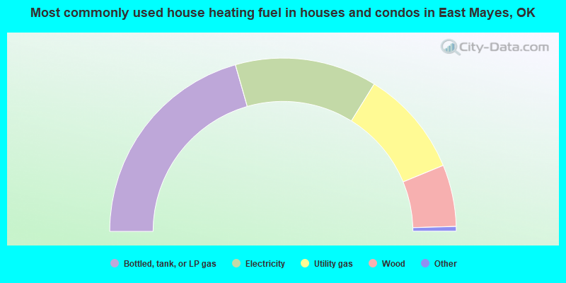
- 41.1%Bottled, tank, or LP gas
- 26.5%Electricity
- 19.9%Utility gas
- 11.5%Wood
- 0.4%Other fuel
- 0.3%Fuel oil, kerosene, etc.
- 0.2%No fuel used
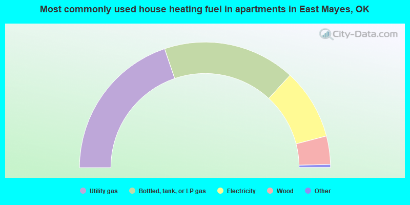
- 39.6%Utility gas
- 34.1%Bottled, tank, or LP gas
- 18.2%Electricity
- 7.3%Wood
- 0.5%No fuel used
- 0.3%Other fuel
East Mayes compared to Oklahoma state average:
- Unemployed percentage below state average.
- Black race population percentage significantly below state average.
- Hispanic race population percentage significantly below state average.
- Foreign-born population percentage significantly below state average.
- Renting percentage below state average.
- Length of stay since moving in significantly above state average.
- Number of rooms per house significantly below state average.
- House age significantly below state average.
- Number of college students below state average.
- Percentage of population with a bachelor's degree or higher below state average.
East Mayes on our top lists:
- #9 on the list of "Top 101 cities with largest percentage of females in industries: hardware, plumbing and heating equipment, and supplies merchant wholesalers (population 5,000+)"
- #16 on the list of "Top 101 cities with largest percentage of males in occupations: metal workers and plastic workers (population 5,000+)"
- #19 on the list of "Top 101 cities with largest percentage of males in industries: metal and metal products (population 5,000+)"
- #22 on the list of "Top 101 cities with largest percentage of males in occupations: construction trades workers except carpenters, electricians, painters, plumbers, and construction laborers (population 5,000+)"
- #26 on the list of "Top 101 cities with largest percentage of females in occupations: nursing, psychiatric, and home health aides (population 5,000+)"
- #40 on the list of "Top 101 cities with largest percentage of females in industries: transportation equipment (population 5,000+)"
- #58 on the list of "Top 101 cities with largest percentage of males in industries: petroleum and coal products (population 5,000+)"
- #65 on the list of "Top 101 cities with largest percentage of females in occupations: plant and system operators (population 5,000+)"
- #70 on the list of "Top 101 cities with largest percentage of females in occupations: carpenters (population 5,000+)"
- #70 on the list of "Top 101 cities with largest percentage of males in industries: nonmetallic mineral products (population 5,000+)"
- #72 on the list of "Top 101 cities with largest percentage of females in industries: motor vehicle and parts dealers (population 5,000+)"
- #77 on the list of "Top 101 cities with the largest percentage of people in mental (psychiatric) hospitals or wards (population 1,000+)"
- #81 on the list of "Top 101 cities with largest percentage of females in occupations: assemblers and fabricators (population 5,000+)"
- #82 on the list of "Top 101 cities with largest percentage of females in industries: truck transportation (population 5,000+)"
- #90 on the list of "Top 101 cities with largest percentage of females in industries: apparel (population 5,000+)"
- #101 on the list of "Top 101 cities with largest percentage of males in industries: machinery (population 5,000+)"
- #2 on the list of "Top 101 counties with the lowest lead air pollution readings in 2012 (µg/m3)"
- #24 on the list of "Top 101 counties with the highest lead air pollution readings in 2012 (µg/m3)"
- #71 on the list of "Top 101 counties with the highest surface withdrawal of fresh water for public supply"
- #78 on the list of "Top 101 counties with the highest Ozone (1-hour) air pollution readings in 2012 (ppm)"
- #101 on the list of "Top 101 counties with the highest total withdrawal of fresh water for public supply"