Ellenburg, New York
Submit your own pictures of this town and show them to the world
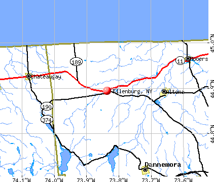
- OSM Map
- General Map
- Google Map
- MSN Map
Population change since 2000: -3.8%
 |
| Males: 881 | |
| Females: 862 |
| Median resident age: | 42.8 years |
| New York median age: | 40.7 years |
Zip codes: 12934.
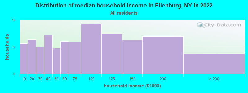
| Ellenburg: | $59,458 |
| NY: | $79,557 |
Estimated per capita income in 2022: $32,450 (it was $16,559 in 2000)
Ellenburg town income, earnings, and wages data
Estimated median house or condo value in 2022: $132,512 (it was $55,500 in 2000)
| Ellenburg: | $132,512 |
| NY: | $400,400 |
Mean prices in 2022: all housing units: $199,088; detached houses: $212,279; townhouses or other attached units: $165,284; in 2-unit structures: $545,537; in 3-to-4-unit structures: $216,109; in 5-or-more-unit structures: $548,924; mobile homes: $82,996
Detailed information about poverty and poor residents in Ellenburg, NY


- 1,69997.5%White alone
- 171.0%Two or more races
- 130.7%Hispanic
- 60.3%American Indian alone
- 60.3%Asian alone
- 20.1%Black alone
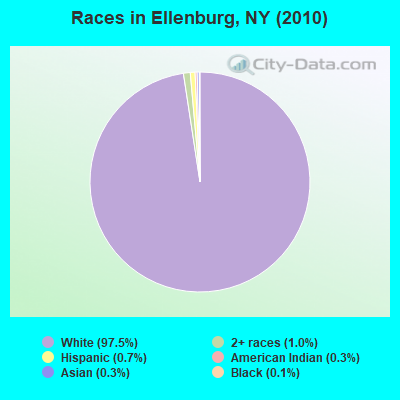
Races in Ellenburg detailed stats: ancestries, foreign born residents, place of birth
 Recent articles from our blog. Our writers, many of them Ph.D. graduates or candidates, create easy-to-read articles on a wide variety of topics.

 | Is the Plattsburgh area the best kept secret in NY State? (262 replies) |
| smaller Upstate NY cities and towns/African American communities (5948 replies) |
| The Adirondacks vs. Vermont (40 replies) |
| Schoharie County Wind Farm Notification (45 replies) |
| Chateaugay/Malone area for an active, young family? (5 replies) |
Latest news from Ellenburg, NY collected exclusively by city-data.com from local newspapers, TV, and radio stations
Ancestries: French (32.0%), Irish (15.0%), French Canadian (11.8%), English (10.5%), United States (8.7%), German (3.3%).
Current Local Time: EST time zone
Land area: 106.4 square miles.
Population density: 16 people per square mile (very low).
54 residents are foreign born (1.7% North America, 0.6% Asia, 0.5% Europe).
| This town: | 3.0% |
| New York: | 20.4% |
| Ellenburg town: | 1.7% ($953) |
| New York: | 1.9% ($2,847) |
Nearest city with pop. 50,000+: Utica, NY  (137.7 miles , pop. 60,651).
Nearest city with pop. 200,000+: Rochester, NY (217.5 miles , pop. 219,773).
Nearest city with pop. 1,000,000+: Bronx, NY (276.8 miles , pop. 1,332,650).
Nearest cities:
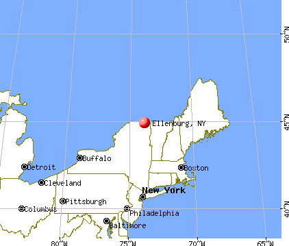
), ), ), )Latitude: 44.85 N, Longitude: 73.92 W
Area code commonly used in this area: 518

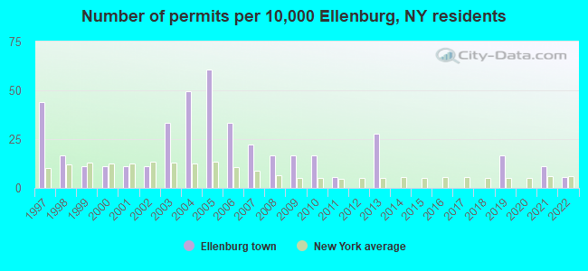
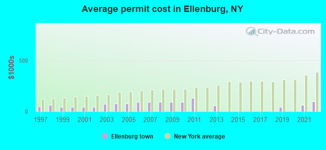
Single-family new house construction building permits:
- 2022: 1 building, cost: $100,000
- 2021: 2 buildings, average cost: $65,000
- 2019: 3 buildings, average cost: $41,700
- 2013: 5 buildings, average cost: $57,000
- 2011: 1 building, cost: $130,000
- 2010: 3 buildings, average cost: $91,700
- 2009: 3 buildings, average cost: $91,700
- 2008: 3 buildings, average cost: $91,700
- 2007: 4 buildings, average cost: $91,700
- 2006: 6 buildings, average cost: $91,700
- 2005: 11 buildings, average cost: $78,700
- 2004: 9 buildings, average cost: $80,100
- 2003: 6 buildings, average cost: $74,200
- 2002: 2 buildings, average cost: $42,500
- 2001: 2 buildings, average cost: $42,500
- 2000: 2 buildings, average cost: $42,500
- 1999: 2 buildings, average cost: $42,500
- 1998: 3 buildings, average cost: $61,700
- 1997: 8 buildings, average cost: $47,000
| Here: | 4.0% |
| New York: | 4.4% |
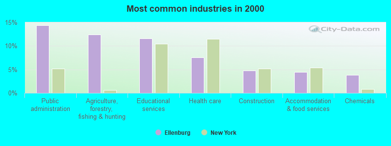
- Public administration (14.4%)
- Agriculture, forestry, fishing & hunting (12.4%)
- Educational services (11.5%)
- Health care (7.6%)
- Construction (4.7%)
- Accommodation & food services (4.5%)
- Chemicals (3.8%)
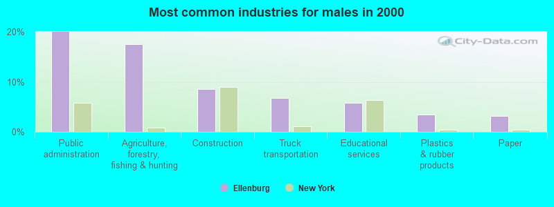
- Public administration (20.0%)
- Agriculture, forestry, fishing & hunting (17.6%)
- Construction (8.6%)
- Truck transportation (6.8%)
- Educational services (5.9%)
- Plastics & rubber products (3.4%)
- Paper (3.2%)
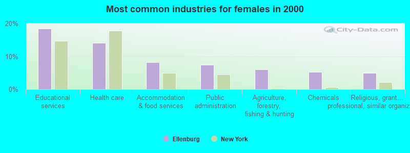
- Educational services (18.5%)
- Health care (14.1%)
- Accommodation & food services (8.3%)
- Public administration (7.5%)
- Agriculture, forestry, fishing & hunting (6.1%)
- Chemicals (5.2%)
- Religious, grantmaking, civic, professional, similar organizations (5.0%)
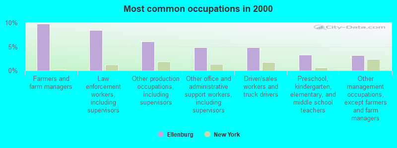
- Farmers and farm managers (9.8%)
- Law enforcement workers, including supervisors (8.4%)
- Other production occupations, including supervisors (6.1%)
- Other office and administrative support workers, including supervisors (4.8%)
- Driver/sales workers and truck drivers (4.8%)
- Preschool, kindergarten, elementary, and middle school teachers (3.3%)
- Other management occupations, except farmers and farm managers (3.2%)
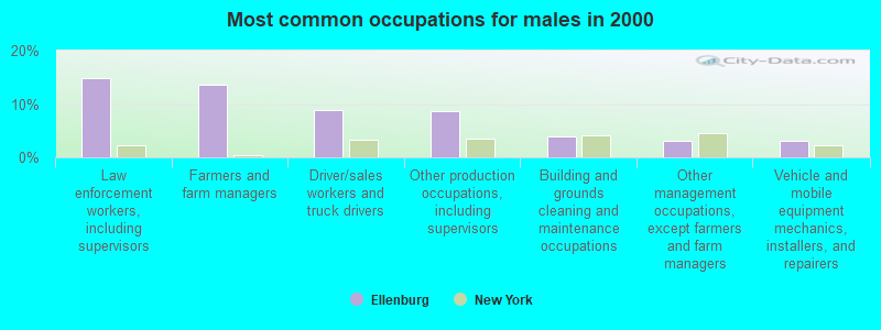
- Law enforcement workers, including supervisors (14.9%)
- Farmers and farm managers (13.5%)
- Driver/sales workers and truck drivers (8.8%)
- Other production occupations, including supervisors (8.6%)
- Building and grounds cleaning and maintenance occupations (3.8%)
- Other management occupations, except farmers and farm managers (3.2%)
- Vehicle and mobile equipment mechanics, installers, and repairers (3.2%)
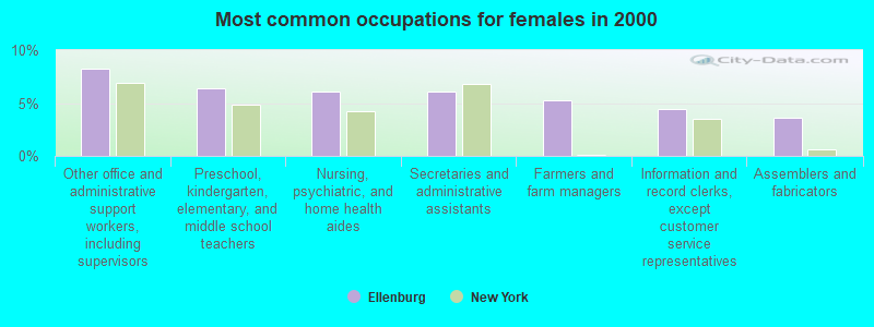
- Other office and administrative support workers, including supervisors (8.3%)
- Preschool, kindergarten, elementary, and middle school teachers (6.4%)
- Nursing, psychiatric, and home health aides (6.1%)
- Secretaries and administrative assistants (6.1%)
- Farmers and farm managers (5.2%)
- Information and record clerks, except customer service representatives (4.4%)
- Assemblers and fabricators (3.6%)
Average climate in Ellenburg, New York
Based on data reported by over 4,000 weather stations


Earthquake activity:
Ellenburg-area historical earthquake activity is above New York state average. It is 77% smaller than the overall U.S. average.On 4/20/2002 at 10:50:47, a magnitude 5.3 (5.3 ML, Depth: 3.0 mi, Class: Moderate, Intensity: VI - VII) earthquake occurred 25.7 miles away from the city center
On 4/20/2002 at 10:50:47, a magnitude 5.2 (5.2 MB, 4.2 MS, 5.2 MW, 5.0 MW) earthquake occurred 26.9 miles away from Ellenburg center
On 10/7/1983 at 10:18:46, a magnitude 5.3 (5.1 MB, 5.3 LG, 5.1 ML) earthquake occurred 65.4 miles away from the city center
On 1/19/1982 at 00:14:42, a magnitude 4.7 (4.5 MB, 4.7 MD, 4.5 LG, Class: Light, Intensity: IV - V) earthquake occurred 148.0 miles away from the city center
On 10/16/2012 at 23:12:25, a magnitude 4.7 (4.7 ML, Depth: 10.0 mi) earthquake occurred 183.4 miles away from Ellenburg center
On 4/8/2003 at 15:06:14, a magnitude 3.7 (3.7 MB, Depth: 6.2 mi, Class: Light, Intensity: II - III) earthquake occurred 26.3 miles away from the city center
Magnitude types: regional Lg-wave magnitude (LG), body-wave magnitude (MB), duration magnitude (MD), local magnitude (ML), surface-wave magnitude (MS), moment magnitude (MW)
Natural disasters:
The number of natural disasters in Clinton County (15) is near the US average (15).Major Disasters (Presidential) Declared: 9
Emergencies Declared: 5
Causes of natural disasters: Floods: 5, Storms: 5, Hurricanes: 3, Winter Storms: 2, Blizzard: 1, Earthquake: 1, Power Outage: 1, Snowstorm: 1, Tornado: 1, Wind: 1, Other: 2 (Note: some incidents may be assigned to more than one category).
Colleges/universities with over 2000 students nearest to Ellenburg:
- SUNY College at Plattsburgh (about 25 miles; Plattsburgh, NY; Full-time enrollment: 5,934)
- University of Vermont (about 44 miles; Burlington, VT; FT enrollment: 11,566)
- Champlain College (about 44 miles; Burlington, VT; FT enrollment: 2,623)
- Community College of Vermont (about 44 miles; Winooski, VT; FT enrollment: 3,394)
- Saint Michael's College (about 45 miles; Colchester, VT; FT enrollment: 2,336)
- SUNY College at Potsdam (about 54 miles; Potsdam, NY; FT enrollment: 4,307)
- Clarkson University (about 55 miles; Potsdam, NY; FT enrollment: 3,472)
Public high school in Ellenburg:
- NORTHERN ADIRONDACK MIDDLE/HIGH SCHOOL (Location: 5586 RT 11, Grades: 6-12)
Public elementary/middle school in Ellenburg:
- NORTHERN ADIRONDACK ELEMENTARY SCHOOL (Students: 398, Location: 5572 RT 11, Grades: KG-5)
Points of interest:
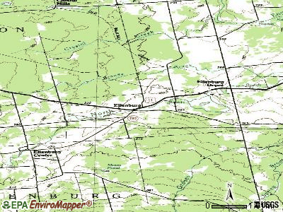
Notable locations in Ellenburg: Star (A), Silver Lane Dairy (B), Sarah A Munsil Free Library (C), Ellenburg Depot Fire Department (D), Ellenburg Center Fire Department (E). Display/hide their locations on the map
Churches in Ellenburg include: Saint Edmund's Church (A), Wesleyan Church (B). Display/hide their locations on the map
Cemeteries: Saint Edmunds Cemetery (1), West Hill Cemetery (2), Sheldon Hill Cemetery (3), Star Road Cemetery (4), Hutchins Cemetery (5). Display/hide their locations on the map
Lake: Moon Pond (A). Display/hide its location on the map
Streams, rivers, and creeks: Weed Brook (A). Display/hide its location on the map
Drinking water stations with addresses in Ellenburg and their reported violations in the past:
ELLENBURG TOWN HALL (Population served: 100, Groundwater):Past monitoring violations:
- 3 routine major monitoring violations
- 2 regular monitoring violations
Drinking water stations with addresses in Ellenburg that have no violations reported:
- MATTHEWS' MOTEL (Population served: 25, Primary Water Source Type: Groundwater)
| This town: | 2.4 people |
| New York: | 2.6 people |
| This town: | 69.8% |
| Whole state: | 63.5% |
| This town: | 6.6% |
| Whole state: | 6.8% |
Likely homosexual households (counted as self-reported same-sex unmarried-partner households)
- Lesbian couples: 0.1% of all households
- Gay men: 0.0% of all households
| This town: | 13.4% |
| Whole state: | 14.6% |
| This town: | 4.4% |
| Whole state: | 7.4% |
3 people in religious group quarters in 2000
For population 15 years and over in Ellenburg:
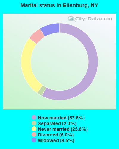
- Never married: 25.6%
- Now married: 57.6%
- Separated: 2.3%
- Widowed: 8.5%
- Divorced: 6.0%
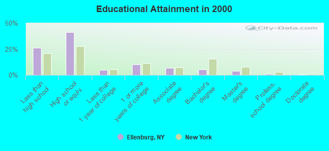
For population 25 years and over in Ellenburg:
- High school or higher: 74.0%
- Bachelor's degree or higher: 10.8%
- Graduate or professional degree: 5.2%
- Unemployed: 5.4%
- Mean travel time to work (commute): 28.7 minutes
| Here: | 12.1 |
| New York average: | 14.2 |
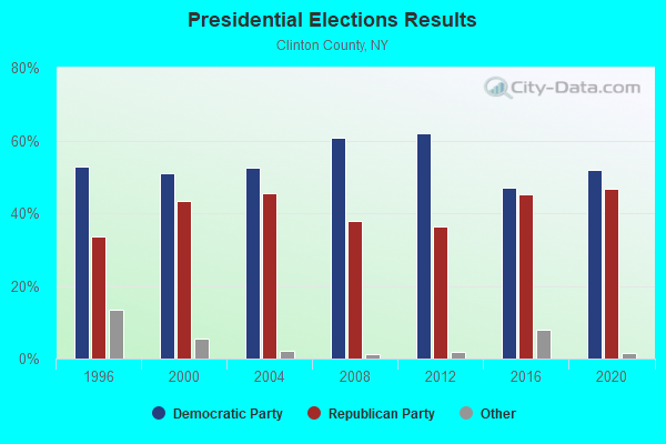
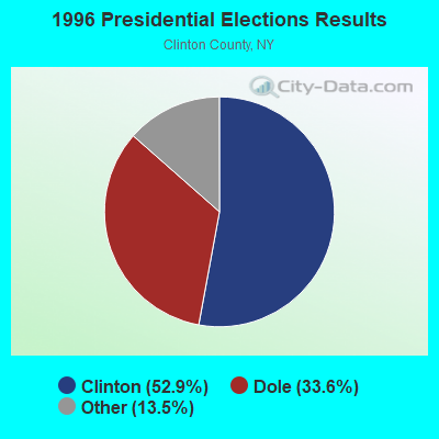
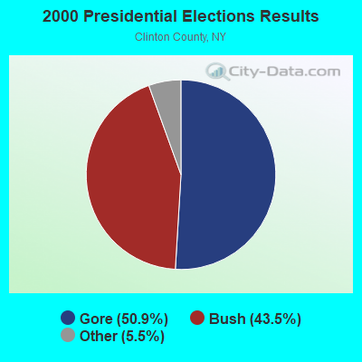
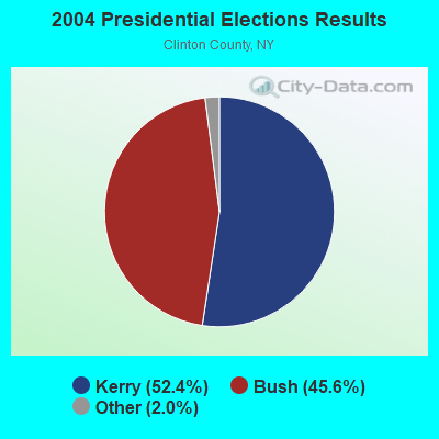
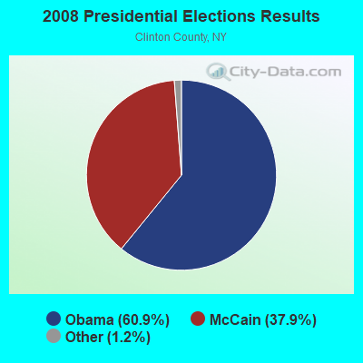
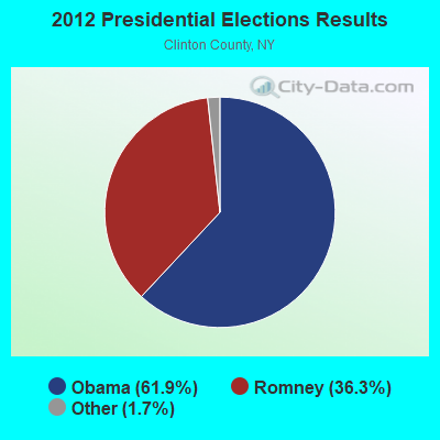
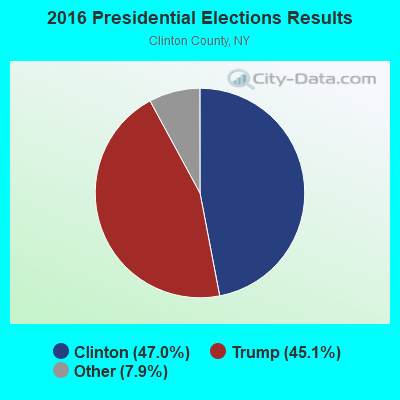
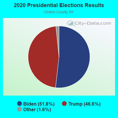
Graphs represent county-level data. Detailed 2008 Election Results
Religion statistics for Ellenburg, NY (based on Clinton County data)
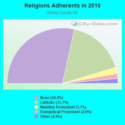
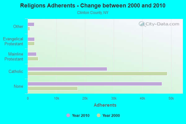
| Religion | Adherents | Congregations |
|---|---|---|
| Catholic | 27,695 | 31 |
| Mainline Protestant | 3,038 | 21 |
| Evangelical Protestant | 2,417 | 21 |
| Other | 2,266 | 7 |
| None | 46,712 | - |
Food Environment Statistics:
| This county: | 2.92 / 10,000 pop. |
| New York: | 4.13 / 10,000 pop. |
| Here: | 0.12 / 10,000 pop. |
| New York: | 0.06 / 10,000 pop. |
| This county: | 0.61 / 10,000 pop. |
| State: | 0.92 / 10,000 pop. |
| This county: | 6.21 / 10,000 pop. |
| New York: | 1.68 / 10,000 pop. |
| Clinton County: | 8.90 / 10,000 pop. |
| State: | 8.82 / 10,000 pop. |
| This county: | 7.3% |
| New York: | 8.2% |
| This county: | 25.4% |
| State: | 23.8% |
| This county: | 13.4% |
| New York: | 15.6% |
Strongest AM radio stations in Ellenburg:
- WICY (1490 AM; 50 kW; MALONE, NY; Owner: CARTIER COMMUNICATIONS INC.)
- WCHP (760 AM; 35 kW; CHAMPLAIN, NY; Owner: CHAMPLAIN RADIO, INC.)
- WTWK (1070 AM; daytime; 5 kW; PLATTSBURGH, NY; Owner: CHAMPLAIN COMMUNICATIONS CORPORATION)
- WEAV (960 AM; 5 kW; PLATTSBURGH, NY; Owner: CLEAR CHANNEL BROADCASTING LICENSES, INC.)
- WVMT (620 AM; 5 kW; BURLINGTON, VT; Owner: SISON BROADCASTING, INC.)
- WIRD (920 AM; 5 kW; LAKE PLACID, NY; Owner: RADIO LAKE PLACID INC)
- WGY (810 AM; 50 kW; SCHENECTADY, NY; Owner: CLEAR CHANNEL BROADCASTING LICENSES, INC.)
- WVAA (1390 AM; 5 kW; BURLINGTON, VT; Owner: RADIO VERMONT, KDR, LLC)
- WNNZ (640 AM; 50 kW; WESTFIELD, MA; Owner: CLEAR CHANNEL BROADCASTING LICENSES, INC.)
- WDEV (550 AM; 5 kW; WATERBURY, VT; Owner: RADIO VERMONT, INC.)
- WRKO (680 AM; 50 kW; BOSTON, MA; Owner: ENTERCOM BOSTON LICENSE, LLC)
- WPTR (1540 AM; 50 kW; ALBANY, NY; Owner: KIMTRON, INC.)
- WCRN (830 AM; 50 kW; WORCESTER, MA; Owner: CARTER BROADCASTING CORPORATION)
Strongest FM radio stations in Ellenburg:
- WCEL (91.9 FM; PLATTSBURGH, NY; Owner: WAMC)
- WYUL (94.7 FM; CHATEAUGAY, NY; Owner: CARTIER COMMUNICATIONS INC.)
- WBTZ (99.9 FM; PLATTSBURGH, NY; Owner: PLATTSBURGH BROADCASTING CORPORATION)
- WXLU (88.3 FM; PERU, NY; Owner: THE ST. LAWRENCE UNIVERSITY)
- WEZF (92.9 FM; BURLINGTON, VT; Owner: CAPSTAR TX LIMITED PARTNERSHIP)
- WVPS (107.9 FM; BURLINGTON, VT; Owner: VERMONT PUBLIC RADIO)
- WLKC (103.3 FM; WATERBURY, VT; Owner: RADIO BROADCASTING SERVICES, INC.)
- WCVT (101.7 FM; STOWE, VT; Owner: RADIO VERMONT CLASSICS, L.L.C.)
- WVNV (96.5 FM; MALONE, NY; Owner: CARTIER COMMUNICATIONS INC.)
- WNCS (104.7 FM; MONTPELIER, VT; Owner: MONTPELIER BROADCASTING, INC.)
- WSLO (90.9 FM; MALONE, NY; Owner: THE ST. LAWRENCE UNIVERSITY)
TV broadcast stations around Ellenburg:
- W49BI (Channel 49; ELLENBURG, NY; Owner: PLATTSBURGH PARTNERS)
- WCFE-TV (Channel 57; PLATTSBURGH, NY; Owner: MOUNTAIN LAKE PUBLIC TELEVISION COUNCIL)
- WPTZ (Channel 5; NORTH POLE, NY; Owner: HEARST-ARGYLE STATIONS, INC.)
- Ellenburg, New York
- Fatal accident count14
- Vehicles involved in fatal accidents21
- Fatal accidents involving drunk persons:5
- Fatalities14
- Persons involved in fatal accidents34
- Pedestrians involved in fatal accidents0
- New York average
- Fatal accident count13314
- Vehicles involved in fatal accidents20059
- Fatal accidents involving drunk persons3111
- Fatalities14352
- Persons involved in fatal accidents32005
- Pedestrians involved in fatal accidents4488
- National Bridge Inventory (NBI) Statistics
- 12Number of bridges
- 66ft / 20.0mTotal length
- $8,839,000Total costs
- 12,396Total average daily traffic
- 1,503Total average daily truck traffic
- 13,521Total future (year 2035) average daily traffic
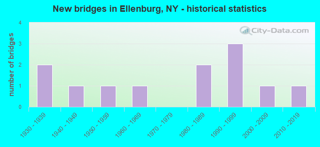
- New bridges - historical statistics
- 21930-1939
- 11940-1949
- 11950-1959
- 11960-1969
- 21980-1989
- 31990-1999
- 12000-2009
- 12010-2019
FCC Registered Broadcast Land Mobile Towers:
4- WEST HILL, 878 West Hill Road (Lat: 44.852139 Lon: -73.973528), Type: Ltower, Structure height: 55 m, Overall height: 58.4 m, Call Sign: WPCJ415,
Assigned Frequencies: 851.887 MHz, 852.362 MHz, 852.562 MHz, 852.812 MHz, 853.062 MHz, 852.162 MHz, 851.312 MHz, Grant Date: 05/19/2015, Expiration Date: 07/20/2025, Certifier: James King, Registrant: V-Comm, L.L.C., 2540 Us Highway 130, Suite 101, Cranbury, NJ 08512, Phone: (609) 655-1200, Fax: (609) 409-1927, Email:
- Westhill (Lat: 44.854194 Lon: -73.978750), Type: Tower, Structure height: 51 m, Overall height: 54 m, Call Sign: WPVK914,
Assigned Frequencies: 456.250 MHz, Grant Date: 05/17/2012, Expiration Date: 07/08/2022, Cancellation Date: 09/24/2022, Certifier: Frank A Miller, Registrant: New York Power Authority, 123 Main Street, White Plains, NY 10601, Phone: (914) 681-6225, Fax: (914) 681-6805, Email:
- WEST HILL, 878 West Hill Road (Lat: 44.852139 Lon: -73.973528), Type: Ltower, Structure height: 55 m, Overall height: 58.4 m, Call Sign: WPVX589,
Assigned Frequencies: 153.875 MHz, Grant Date: 08/24/2022, Expiration Date: 08/30/2032, Certifier: James A King, Registrant: V-Comm, L.L.C, 2147 Route 27 South, Suite 102, Edison, NJ 08817, Phone: (609) 655-1200, Fax: (609) 409-1927, Email:
- WEST HILL, 878 West Hill Road (Lat: 44.852139 Lon: -73.973528), Type: Ltower, Structure height: 55 m, Overall height: 58.4 m, Call Sign: WRTR329,
Assigned Frequencies: 852.162 MHz, Grant Date: 07/15/2022, Expiration Date: 07/15/2032, Certifier: Eric R Day, Registrant: V-Comm, L.L.C., 2147 Route 27, Suite 102, Edison, NJ 08817, Phone: (609) 655-1200, Email:
FCC Registered Paging Towers:
1- West Hill (Lat: 44.852806 Lon: -73.974306), Call Sign: KQZ790,
Assigned Frequencies: 72.0800 MHz, Grant Date: 04/02/2019, Expiration Date: 04/01/2029, Certifier: Kathy M Paskevich, Registrant: Jkl Communications LLC, 142 Avenue C, Williston, VT 05495, Phone: (802) 860-0000, Fax: (802) 860-5037, Email:
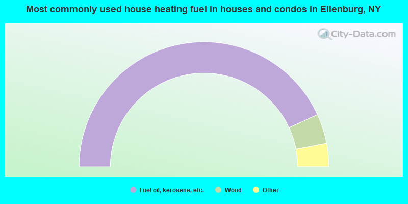
- 86.3%Fuel oil, kerosene, etc.
- 7.7%Wood
- 3.5%Electricity
- 2.1%Bottled, tank, or LP gas
- 0.4%Coal or coke
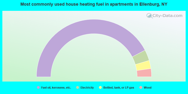
- 84.7%Fuel oil, kerosene, etc.
- 6.1%Electricity
- 4.6%Bottled, tank, or LP gas
- 4.6%Wood
Ellenburg compared to New York state average:
- Median house value significantly below state average.
- Unemployed percentage below state average.
- Black race population percentage significantly below state average.
- Hispanic race population percentage significantly below state average.
- Foreign-born population percentage significantly below state average.
- Renting percentage below state average.
- Length of stay since moving in significantly above state average.
- Number of rooms per house significantly below state average.
- House age significantly below state average.
- Percentage of population with a bachelor's degree or higher significantly below state average.