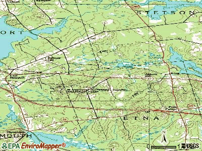
Etna, Maine

Submit your own pictures of this town and show them to the world
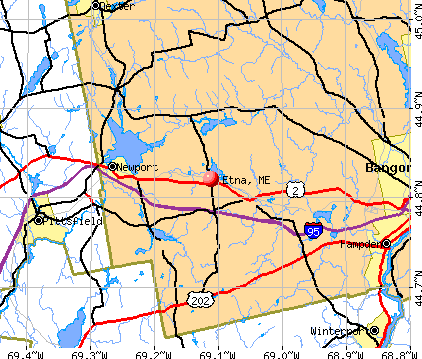
- OSM Map
- General Map
- Google Map
- MSN Map
Population change since 2000: +23.1%
| Males: 632 | |
| Females: 614 |
| Median resident age: | 39.1 years |
| Maine median age: | 43.0 years |
Zip codes: 04434.
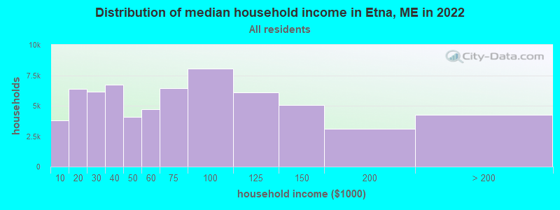
| Etna: | $60,076 |
| ME: | $69,543 |
Estimated per capita income in 2022: $29,416 (it was $14,633 in 2000)
Etna town income, earnings, and wages data
Estimated median house or condo value in 2022: $186,308 (it was $71,600 in 2000)
| Etna: | $186,308 |
| ME: | $290,600 |
Mean prices in 2022: all housing units: $235,563; detached houses: $252,705; townhouses or other attached units: $267,749; in 2-unit structures: $255,332; in 3-to-4-unit structures: $815,300; in 5-or-more-unit structures: $185,873; mobile homes: $93,017; occupied boats, rvs, vans, etc.: $21,333
Detailed information about poverty and poor residents in Etna, ME


- 1,20296.5%White alone
- 141.1%Hispanic
- 90.7%Black alone
- 80.6%American Indian alone
- 80.6%Two or more races
- 50.4%Asian alone
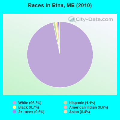
Races in Etna detailed stats: ancestries, foreign born residents, place of birth
According to our research of Maine and other state lists, there were 2 registered sex offenders living in Etna, Maine as of April 29, 2024.
The ratio of all residents to sex offenders in Etna is 623 to 1.
The ratio of registered sex offenders to all residents in this city is lower than the state average.
 Recent articles from our blog. Our writers, many of them Ph.D. graduates or candidates, create easy-to-read articles on a wide variety of topics.

 | Maine weather thread (3207 replies) |
| off grid living in maine (39 replies) |
| Rural Maine questions (North or Central) (24 replies) |
| Looking for Land or Small Dwelling - ASKING KINDLY FOR YOUR HELP :) (4 replies) |
| Poland Maine Cabin/Camp Question??? (21 replies) |
| Building Moving Companies in ME??? (2 replies) |
Latest news from Etna, ME collected exclusively by city-data.com from local newspapers, TV, and radio stations
Ancestries: English (17.9%), Irish (15.7%), French (13.5%), United States (11.5%), German (4.4%), Scottish (4.3%).
Current Local Time: EST time zone
Incorporated on 02/15/1820
Elevation: 234 feet
Land area: 24.4 square miles.
Population density: 51 people per square mile (very low).
14 residents are foreign born
| This town: | 1.4% |
| Maine: | 2.9% |
| Etna town: | 1.2% ($825) |
| Maine: | 1.5% ($1,417) |
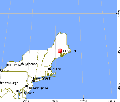
Nearest city with pop. 50,000+: Portland, ME  (95.9 miles , pop. 64,249).
Nearest city with pop. 200,000+: Boston, MA (196.7 miles , pop. 589,141).
Nearest city with pop. 1,000,000+: Bronx, NY (363.4 miles , pop. 1,332,650).
Nearest cities:
), ), ), ), )Latitude: 44.79 N, Longitude: 69.13 W
Area code: 207

| Here: | 4.6% |
| Maine: | 3.4% |
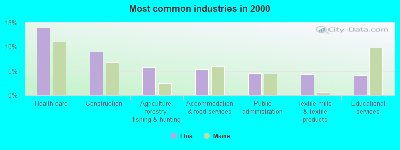
- Health care (14.0%)
- Construction (9.0%)
- Agriculture, forestry, fishing & hunting (5.8%)
- Accommodation & food services (5.4%)
- Public administration (4.6%)
- Textile mills & textile products (4.4%)
- Educational services (4.2%)
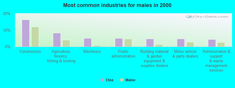
- Construction (16.3%)
- Agriculture, forestry, fishing & hunting (8.3%)
- Machinery (5.2%)
- Public administration (5.2%)
- Building material & garden equipment & supplies dealers (4.8%)
- Motor vehicle & parts dealers (4.8%)
- Administrative & support & waste management services (4.4%)
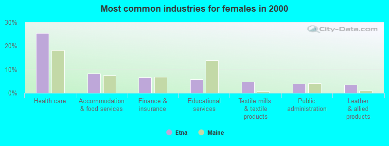
- Health care (25.4%)
- Accommodation & food services (8.3%)
- Finance & insurance (6.6%)
- Educational services (5.7%)
- Textile mills & textile products (4.8%)
- Public administration (3.9%)
- Leather & allied products (3.5%)
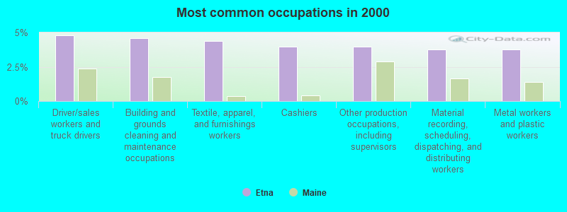
- Driver/sales workers and truck drivers (4.8%)
- Building and grounds cleaning and maintenance occupations (4.6%)
- Textile, apparel, and furnishings workers (4.4%)
- Cashiers (4.0%)
- Other production occupations, including supervisors (4.0%)
- Material recording, scheduling, dispatching, and distributing workers (3.8%)
- Metal workers and plastic workers (3.8%)
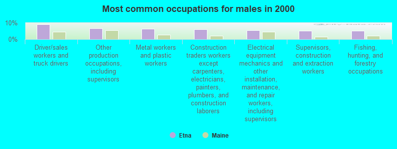
- Driver/sales workers and truck drivers (9.1%)
- Other production occupations, including supervisors (6.7%)
- Metal workers and plastic workers (6.3%)
- Construction traders workers except carpenters, electricians, painters, plumbers, and construction laborers (6.0%)
- Electrical equipment mechanics and other installation, maintenance, and repair workers, including supervisors (5.6%)
- Supervisors, construction and extraction workers (5.2%)
- Fishing, hunting, and forestry occupations (5.2%)

- Textile, apparel, and furnishings workers (9.2%)
- Cashiers (7.5%)
- Other office and administrative support workers, including supervisors (6.6%)
- Building and grounds cleaning and maintenance occupations (5.7%)
- Registered nurses (4.8%)
- Other management occupations, except farmers and farm managers (3.9%)
- Cooks and food preparation workers (3.9%)
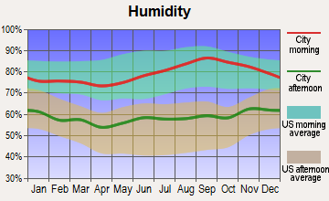
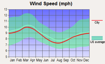
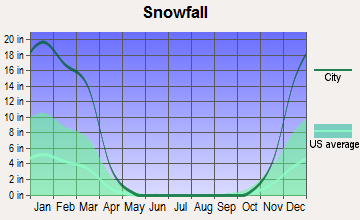
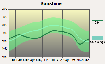
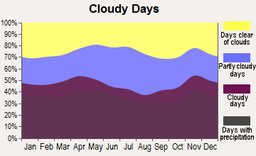
Average climate in Etna, Maine
Based on data reported by over 4,000 weather stations
(lower is better)
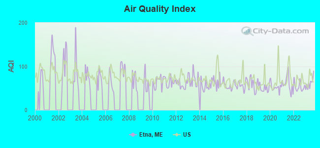
Air Quality Index (AQI) level in 2023 was 61.1. This is about average.
| City: | 61.1 |
| U.S.: | 72.6 |
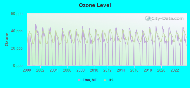
Ozone [ppb] level in 2023 was 33.6. This is about average. Closest monitor was 8.4 miles away from the city center.
| City: | 33.6 |
| U.S.: | 33.3 |
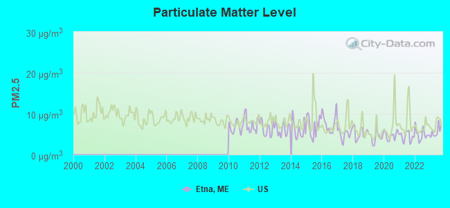
Particulate Matter (PM2.5) [µg/m3] level in 2023 was 5.62. This is significantly better than average. Closest monitor was 17.8 miles away from the city center.
| City: | 5.62 |
| U.S.: | 8.11 |
Earthquake activity:
Etna-area historical earthquake activity is significantly above Maine state average. It is 81% smaller than the overall U.S. average.On 4/20/2002 at 10:50:47, a magnitude 5.3 (5.3 ML, Depth: 3.0 mi, Class: Moderate, Intensity: VI - VII) earthquake occurred 225.4 miles away from the city center
On 10/16/2012 at 23:12:25, a magnitude 4.7 (4.7 ML, Depth: 10.0 mi, Class: Light, Intensity: IV - V) earthquake occurred 111.7 miles away from the city center
On 4/20/2002 at 10:50:47, a magnitude 5.2 (5.2 MB, 4.2 MS, 5.2 MW, 5.0 MW) earthquake occurred 226.6 miles away from Etna center
On 10/7/1983 at 10:18:46, a magnitude 5.3 (5.1 MB, 5.3 LG, 5.1 ML) earthquake occurred 263.9 miles away from the city center
On 1/19/1982 at 00:14:42, a magnitude 4.7 (4.5 MB, 4.7 MD, 4.5 LG) earthquake occurred 151.4 miles away from the city center
On 2/26/1999 at 03:38:43, a magnitude 3.8 (3.8 LG, Depth: 2.0 mi, Class: Light, Intensity: II - III) earthquake occurred 28.5 miles away from Etna center
Magnitude types: regional Lg-wave magnitude (LG), body-wave magnitude (MB), duration magnitude (MD), local magnitude (ML), surface-wave magnitude (MS), moment magnitude (MW)
Natural disasters:
The number of natural disasters in Penobscot County (19) is greater than the US average (15).Major Disasters (Presidential) Declared: 11
Emergencies Declared: 7
Causes of natural disasters: Floods: 9, Storms: 8, Snows: 5, Heavy Rains: 2, Blizzard: 1, Hurricane: 1, Ice Storm: 1, Snowfall: 1, Wind: 1, Winter Storm: 1, Other: 2 (Note: some incidents may be assigned to more than one category).
Hospitals and medical centers near Etna:
- BIRCH GROVE REHAB AND LIVING CTR (Nursing Home, about 12 miles away; PITTSFIELD, ME)
- PITTSFIELD REHAB AND NURSING (Nursing Home, about 12 miles away; PITTSFIELD, ME)
- SEBASTICOOK VALLEY HOSPITAL Critical Access Hospitals (about 13 miles away; PITTSFIELD, ME)
- SQUARE ROAD GROUP HOME (Hospital, about 13 miles away; SAINT ALBANS, ME)
- BANGOR AREA VISITING NURSES (Home Health Center, about 16 miles away; BANGOR, ME)
- HOSPICE OF EASTERN MAINE (Hospital, about 16 miles away; BANGOR, ME)
Colleges/universities with over 2000 students nearest to Etna:
- Husson University (about 18 miles; Bangor, ME; Full-time enrollment: 2,421)
- University of Maine (about 24 miles; Orono, ME; FT enrollment: 8,931)
- University of Maine at Augusta (about 46 miles; Augusta, ME; FT enrollment: 3,204)
- University of Maine at Farmington (about 51 miles; Farmington, ME; FT enrollment: 2,036)
- Saint Joseph's College of Maine (about 95 miles; Standish, ME; FT enrollment: 2,010)
- Southern Maine Community College (about 96 miles; South Portland, ME; FT enrollment: 4,666)
- University of Southern Maine (about 97 miles; Portland, ME; FT enrollment: 6,647)
Public elementary/middle school in Etna:
- ETNA-DIXMONT SCHOOL (Students: 279, Location: 2100 DIXMONT ROAD, Grades: PK-8)
Points of interest:
Notable locations in Etna: Camp Etna (A), Etna Municipal Fire Department (B), Etna Fire Department First Responders (C). Display/hide their locations on the map
Cemeteries: Stuart Cemetery (1), Pleasant Hill Cemetery (2), Etna Cemetery (3). Display/hide their locations on the map
Swamps: Etna Bog (A). Display/hide its location on the map
| This town: | 2.6 people |
| Maine: | 2.3 people |
| This town: | 70.3% |
| Whole state: | 62.9% |
| This town: | 14.3% |
| Whole state: | 9.4% |
Likely homosexual households (counted as self-reported same-sex unmarried-partner households)
- Lesbian couples: 0.6% of all households
- Gay men: 0.6% of all households
| This town: | 18.1% |
| Whole state: | 10.9% |
| This town: | 4.9% |
| Whole state: | 4.1% |
For population 15 years and over in Etna:
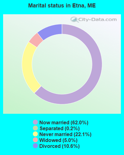
- Never married: 22.1%
- Now married: 62.0%
- Separated: 0.2%
- Widowed: 5.0%
- Divorced: 10.6%
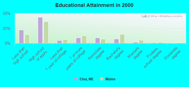
For population 25 years and over in Etna:
- High school or higher: 77.9%
- Bachelor's degree or higher: 10.5%
- Graduate or professional degree: 3.3%
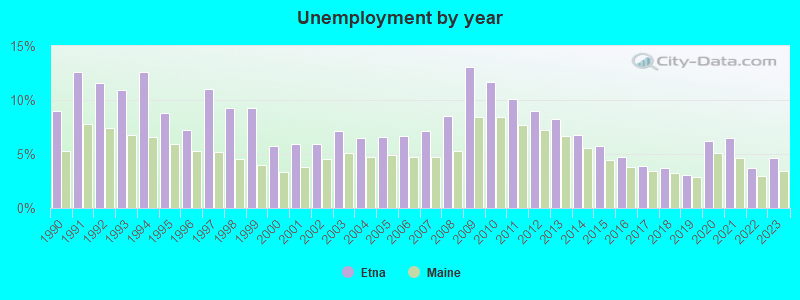
- Unemployed: 9.1%
- Mean travel time to work (commute): 33.0 minutes

| Here: | 9.5 |
| Maine average: | 11.2 |


Graphs represent county-level data. Detailed 2008 Election Results
Religion statistics for Etna, ME (based on Penobscot County data)


| Religion | Adherents | Congregations |
|---|---|---|
| Catholic | 16,581 | 15 |
| Mainline Protestant | 9,715 | 59 |
| Evangelical Protestant | 7,523 | 80 |
| Other | 2,936 | 22 |
| Orthodox | 300 | 1 |
| None | 116,868 | - |
Food Environment Statistics:
| Penobscot County: | 2.29 / 10,000 pop. |
| Maine: | 2.80 / 10,000 pop. |
| Penobscot County: | 0.13 / 10,000 pop. |
| Maine: | 0.14 / 10,000 pop. |
| This county: | 2.56 / 10,000 pop. |
| Maine: | 2.20 / 10,000 pop. |
| Penobscot County: | 5.72 / 10,000 pop. |
| Maine: | 5.75 / 10,000 pop. |
| Penobscot County: | 7.41 / 10,000 pop. |
| Maine: | 11.02 / 10,000 pop. |
| This county: | 9.0% |
| Maine: | 8.2% |
| Here: | 28.0% |
| State: | 25.0% |
Strongest AM radio stations in Etna:
- WZON (620 AM; 5 kW; BANGOR, ME; Owner: THE ZONE CORPORATION)
- WABI (910 AM; 5 kW; BANGOR, ME; Owner: CLEAR CHANNEL BROADCASTING LICENSES, INC.)
- WSKW (1160 AM; 10 kW; SKOWHEGAN, ME; Owner: MOUNTAIN WIRELESS, INCORPORATED)
- WTME (780 AM; 10 kW; RUMFORD, ME; Owner: MOUNTAIN VALLEY BROADCASTING, INC.)
- WDEA (1370 AM; 5 kW; ELLSWORTH, ME; Owner: CUMULUS LICENSING CORP.)
- WRKO (680 AM; 50 kW; BOSTON, MA; Owner: ENTERCOM BOSTON LICENSE, LLC)
- WFAU (1280 AM; 5 kW; GARDINER, ME; Owner: CAPSTAR TX LIMITED PARTNERSHIP)
- WNZS (1340 AM; 1 kW; VEAZIE, ME; Owner: WATERFRONT COMMUNICATIONS INC.)
- WEEI (850 AM; 50 kW; BOSTON, MA; Owner: ENTERCOM BOSTON LICENSE, LLC)
- WBZ (1030 AM; 50 kW; BOSTON, MA; Owner: INFINITY BROADCASTING OPERATIONS, INC.)
- WCRN (830 AM; 50 kW; WORCESTER, MA; Owner: CARTER BROADCASTING CORPORATION)
- WNNZ (640 AM; 50 kW; WESTFIELD, MA; Owner: CLEAR CHANNEL BROADCASTING LICENSES, INC.)
- WMTW (870 AM; 10 kW; GORHAM, ME; Owner: RADIO PARTNERS OF MAINE, L.P.)
Strongest FM radio stations in Etna:
- WWBX (97.1 FM; BANGOR, ME; Owner: CLEAR CHANNEL BROADCASTING LICENSES, INC.)
- WBFB (104.7 FM; BELFAST, ME; Owner: CLEAR CHANNEL BROADCASTING LICENSES, INC.)
- WQCB (106.5 FM; BREWER, ME; Owner: CUMULUS LICENSING CORP.)
- WKIT-FM (100.3 FM; BREWER, ME; Owner: THE ZONE CORPORATION)
- WJCX (99.5 FM; PITTSFIELD, ME; Owner: CSN INTERNATIONAL)
- WGUY (102.1 FM; DEXTER, ME; Owner: CONCORD MEDIA GROUP, INC.)
- WWMJ (95.7 FM; ELLSWORTH, ME; Owner: CUMULUS LICENSING CORP.)
- WFZX (101.7 FM; SEARSPORT, ME; Owner: CLEAR CHANNEL BROADCASTING LICENSES, INC.)
- WVOM (103.9 FM; HOWLAND, ME; Owner: CLEAR CHANNEL BROADCASTING LICENSES, INC.)
- WTOS-FM (105.1 FM; SKOWHEGAN, ME; Owner: CAPSTAR TX LIMITED PARTNERSHIP)
- WHCF (88.5 FM; BANGOR, ME; Owner: BANGOR BAPTIST CHURCH)
- WMEH (90.9 FM; BANGOR, ME; Owner: MAINE PUBLIC BROADCASTING CORPORATION)
- WEZQ (92.9 FM; BANGOR, ME; Owner: CUMULUS LICENSING CORP.)
- WMEP (90.5 FM; CAMDEN, ME; Owner: MAINE PUBLIC BROADCASTING CORP.)
- WQSS (102.5 FM; CAMDEN, ME; Owner: CLEAR CHANNEL BROADCASTING LICENSES, INC.)
- WCTB (93.5 FM; FAIRFIELD, ME; Owner: MOUNTAIN WIRELESS, INC.)
- WBZN (107.3 FM; OLD TOWN, ME; Owner: CUMULUS LICENSING CORP.)
- WERU-FM (89.9 FM; BLUE HILL, ME; Owner: SALT POND COMMUNITY B/C COMPANY)
- WHQO (107.9 FM; SKOWHEGAN, ME; Owner: MOUNTAIN WIRELESS, INC.)
- WWWA (95.3 FM; WINSLOW, ME; Owner: LIGHT OF LIFE MINISTRIES, INC.)
TV broadcast stations around Etna:
- WABI-TV (Channel 5; BANGOR, ME; Owner: COMMUNITY BROADCASTING SERVICE)
- W36CK (Channel 36; BANGOR, ME; Owner: TRINITY BROADCASTING NETWORK)
- WCKD-LP (Channel 30; BANGOR/DEDHAM, ME; Owner: J. MCLEOD, ME FAMILY B/CING., INC.)
- WLBZ (Channel 2; BANGOR, ME; Owner: PACIFIC AND SOUTHERN COMPANY, INC.)
- WBGR-LP (Channel 33; BANGOR/DEDHAM, ME; Owner: MAINE FAMILY BROADCASTING, INC.)
- WMEB-TV (Channel 12; ORONO, ME; Owner: MAINE PUBLIC BROADCASTING CORPORATION)
- Etna, Maine
- Fatal accident count12
- Vehicles involved in fatal accidents17
- Fatal accidents involving drunk persons:0
- Fatalities12
- Persons involved in fatal accidents21
- Pedestrians involved in fatal accidents0
- Maine average
- Fatal accident count1800
- Vehicles involved in fatal accidents2646
- Fatal accidents involving drunk persons637
- Fatalities1984
- Persons involved in fatal accidents4413
- Pedestrians involved in fatal accidents126
- National Bridge Inventory (NBI) Statistics
- 3Number of bridges
- 56ft / 17.1mTotal length
- 20,556Total average daily traffic
- 1,027Total average daily truck traffic
- 28,828Total future (year 2036) average daily traffic
FCC Registered Antenna Towers:
30 (See the full list of FCC Registered Antenna Towers in Etna)FCC Registered Microwave Towers:
1- ETNA, 6 M S Of Sr-69 & 1.3 M W Sr143 (Lat: 44.780611 Lon: -69.130028), Overall height: 80.2 m, Call Sign: WLT436,
Assigned Frequencies: 2162.00 MHz, Grant Date: 06/14/1993, Expiration Date: 02/01/2001, Cancellation Date: 05/06/2001, Registrant: Bangor Cellular Telephone LP, 8410 W Bryn Mawr Ave, Chicago, IL 60631
FCC Registered Amateur Radio Licenses:
5- Call Sign: N1FHT, Previous Call Sign: KA2DNE, Grant Date: 11/10/1987, Expiration Date: 11/10/1997, Cancellation Date: 11/11/1999, Registrant: Charles A Vaclavik, Box 76b Rfd 1, Etna, ME 04434
- Call Sign: N1QPK, Licensee ID: L00761000, Grant Date: 09/26/2023, Expiration Date: 11/09/2033, Certifier: Alison R Carter, Registrant: Alison R Carter, 34 Old County Rd, Etna, ME 04434
- Call Sign: KB1FDO, Licensee ID: L00237711, Grant Date: 06/12/2020, Expiration Date: 06/12/2030, Certifier: Victor M Fratello, Registrant: Victor M Fratello, 582 Stage Road, Etna, ME 04434-3216
- Call Sign: KJ4GBD, Licensee ID: L01424974, Grant Date: 07/11/2018, Expiration Date: 08/20/2028, Certifier: Christopher M Carter, Registrant: Christopher M Carter, 34 Old County Rd, Etna, ME 04434
- Call Sign: KC1RPE, Licensee ID: L02579085, Grant Date: 07/13/2022, Expiration Date: 07/13/2032, Certifier: John A Storen, Registrant: John A Storen, 1042 W Etna Rd, Etna, ME 04434-3431
2003 - 2018 National Fire Incident Reporting System (NFIRS) incidents
- Fire incident types reported to NFIRS in Etna, ME
- 9672.7%Structure Fires
- 2720.5%Outside Fires
- 75.3%Mobile Property/Vehicle Fires
- 21.5%Other
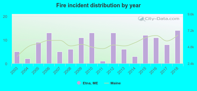 Based on the data from the years 2003 - 2018 the average number of fires per year is 8. The highest number of reported fires - 14 took place in 2018, and the least - 1 in 2011. The data has an increasing trend.
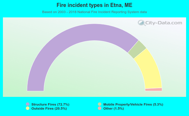 When looking into fire subcategories, the most reports belonged to: Structure Fires (72.7%), and Outside Fires (20.5%).
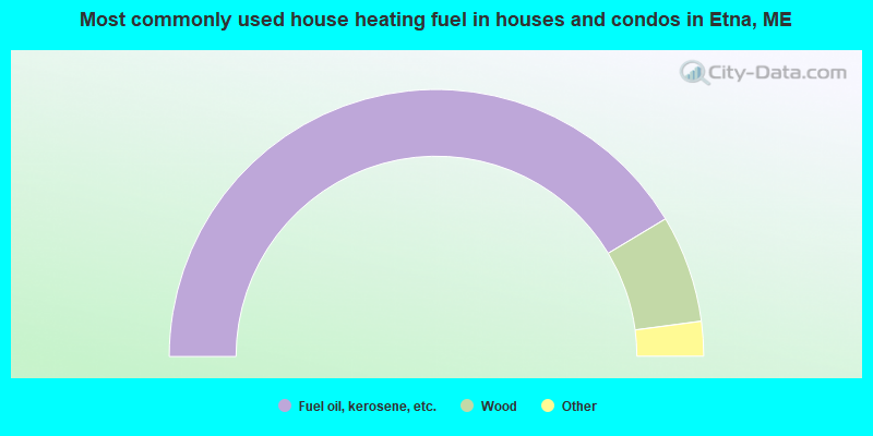
- 82.7%Fuel oil, kerosene, etc.
- 13.0%Wood
- 2.5%Bottled, tank, or LP gas
- 1.1%Coal or coke
- 0.6%Electricity
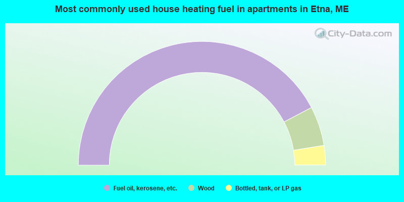
- 84.6%Fuel oil, kerosene, etc.
- 10.3%Wood
- 5.1%Bottled, tank, or LP gas
Etna compared to Maine state average:
- Median house value below state average.
- Black race population percentage below state average.
- Foreign-born population percentage significantly below state average.
- Renting percentage below state average.
- Length of stay since moving in significantly above state average.
- Number of rooms per house significantly below state average.
- House age significantly below state average.
- Percentage of population with a bachelor's degree or higher significantly below state average.