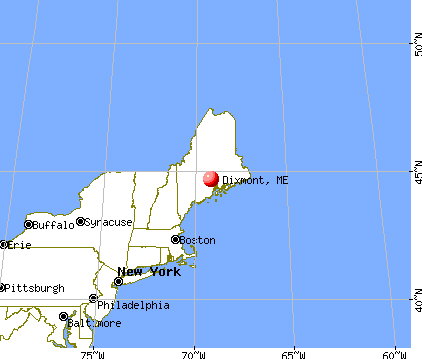
Dixmont, Maine
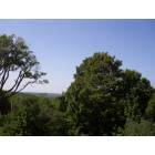
Submit your own pictures of this town and show them to the world
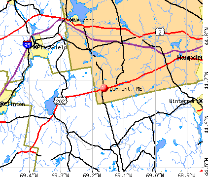
- OSM Map
- General Map
- Google Map
- MSN Map
Population change since 2000: +10.9%
 |
| Males: 594 | |
| Females: 587 |
| Median resident age: | 44.8 years |
| Maine median age: | 43.0 years |
Zip codes: 04932.
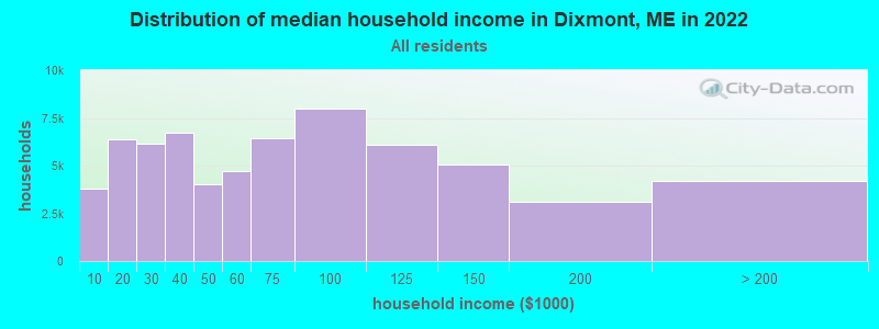
| Dixmont: | $60,028 |
| ME: | $69,543 |
Estimated per capita income in 2022: $31,815 (it was $15,826 in 2000)
Dixmont town income, earnings, and wages data
Estimated median house or condo value in 2022: $204,783 (it was $78,700 in 2000)
| Dixmont: | $204,783 |
| ME: | $290,600 |
Mean prices in 2022: all housing units: $235,563; detached houses: $252,705; townhouses or other attached units: $267,749; in 2-unit structures: $255,332; in 3-to-4-unit structures: $815,300; in 5-or-more-unit structures: $185,873; mobile homes: $93,017; occupied boats, rvs, vans, etc.: $21,333
Detailed information about poverty and poor residents in Dixmont, ME
Compare current foreclosures near Dixmont, ME:
| Photo | Address | Area | Beds / Baths | Price | Details |
|---|---|---|---|---|---|

|
#1
Mount Ephraim Rd
Searsport, ME 04974
|
1,972 sq. feet
|
2 baths 4 beds |
$154,900
|
show details |

|
#2
Kenduskeag Levant Rd
Kenduskeag, ME 04450
|
- sq. feet
|
2 baths 3 beds |
show details | |

|
#3
Main St
Pittsfield, ME 04967
|
1,940 sq. feet
|
2 baths 4 beds |
show details | |

|
#4
Western Ave
Hampden, ME 04444
|
1,976 sq. feet
|
2 baths 4 beds |
show details | |

|
#5
Ichabod Ln
Hampden, ME 04444
|
960 sq. feet
|
1 baths 3 beds |
show details | |

|
#6
Elm St
Newport, ME 04953
|
2,440 sq. feet
|
2 baths 4 beds |
show details | |

|
#7
Western Ave
Hampden, ME 04444
|
1,825 sq. feet
|
1 baths 3 beds |
show details | |

|
#8
Smokey Ln
Bangor, ME 04401
|
2,434 sq. feet
|
2 baths 3 beds |
show details | |

|
#9
Pleasant Hill Ln
Orrington, ME 04474
|
- sq. feet
|
- baths - beds |
show details | |

|
#10
Muskrat Farm Rd
Stockton Springs, ME 04981
|
- sq. feet
|
- baths - beds |
show details |
| Photo | Address | Area | Beds / Baths | Price | Details |
|---|---|---|---|---|---|

|
#11
Wolfboro Rd
Stetson, ME 04488
|
- sq. feet
|
- baths - beds |
show details | |

|
#12
Hampden Rd
Carmel, ME 04419
|
- sq. feet
|
- baths - beds |
show details | |

|
#13
Loop Rd
Searsport, ME 04974
|
- sq. feet
|
- baths - beds |
show details | |

|
#14
Karen St
Palmyra, ME 04965
|
- sq. feet
|
- baths - beds |
show details | |

|
#15
Indian Hill Ln
Frankfort, ME 04438
|
- sq. feet
|
- baths - beds |
show details | |

|
#16
Ames Ct
Pittsfield, ME 04967
|
- sq. feet
|
- baths - beds |
show details | |
|
|
#17
York Rd
Bangor, ME 04401
|
- sq. feet
|
- baths - beds |
show details | |

|
#18
Harrison St
Pittsfield, ME 04967
|
- sq. feet
|
- baths - beds |
show details | |

|
#19
Belfast Rd
Thorndike, ME 04986
|
- sq. feet
|
- baths - beds |
show details | |

|
Check over 1 million property listings on Foreclosure.com!
|
browse all offers | |||

- 1,15697.9%White alone
- 100.8%Hispanic
- 70.6%American Indian alone
- 50.4%Two or more races
- 20.2%Asian alone
- 10.08%Black alone
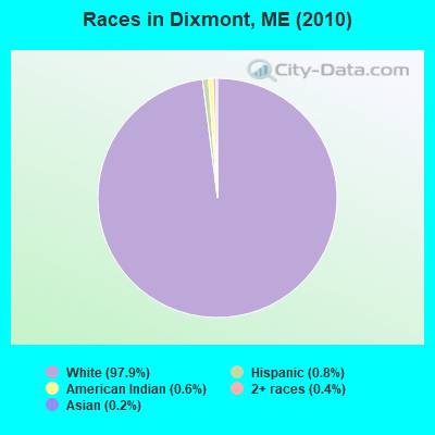
Races in Dixmont detailed stats: ancestries, foreign born residents, place of birth
According to our research of Maine and other state lists, there were 3 registered sex offenders living in Dixmont, Maine as of April 29, 2024.
The ratio of all residents to sex offenders in Dixmont is 394 to 1.
 Recent articles from our blog. Our writers, many of them Ph.D. graduates or candidates, create easy-to-read articles on a wide variety of topics.

 | Maine weather thread (3207 replies) |
| Cannabis industry (28 replies) |
| Show us your bed warmers! (41 replies) |
| Hunting for meat intake/trapping for income (63 replies) |
| What do you like and don't like about living in Maine? (102 replies) |
| Old One Room Schoolhouses in Dixmont (9 replies) |
Latest news from Dixmont, ME collected exclusively by city-data.com from local newspapers, TV, and radio stations
Ancestries: English (15.4%), United States (14.4%), Irish (12.9%), German (10.0%), French (9.5%), Scottish (5.6%).
Current Local Time: EST time zone
Incorporated on 02/28/1807
Elevation: 543 feet
Land area: 36.3 square miles.
Population density: 32 people per square mile (very low).
15 residents are foreign born
| This town: | 1.4% |
| Maine: | 2.9% |
| Dixmont town: | 0.8% ($659) |
| Maine: | 1.5% ($1,417) |
Nearest city with pop. 50,000+: Portland, ME  (90.8 miles , pop. 64,249).
Nearest city with pop. 200,000+: Boston, MA (191.1 miles , pop. 589,141).
Nearest city with pop. 1,000,000+: Bronx, NY (358.7 miles , pop. 1,332,650).
Nearest cities:
), ), ), ), ), )Latitude: 44.69 N, Longitude: 69.12 W
Area code commonly used in this area: 207

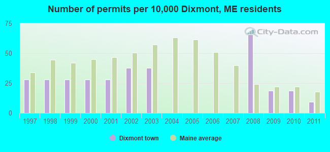
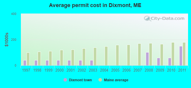
Single-family new house construction building permits:
- 2011: 1 building, cost: $150,000
- 2010: 2 buildings, average cost: $58,800
- 2009: 2 buildings, average cost: $58,800
- 2008: 7 buildings, average cost: $101,600
- 2003: 4 buildings, average cost: $41,000
- 2002: 4 buildings, average cost: $41,000
- 2001: 3 buildings, average cost: $41,000
- 2000: 3 buildings, average cost: $41,000
- 1999: 3 buildings, average cost: $41,000
- 1998: 3 buildings, average cost: $41,000
- 1997: 3 buildings, average cost: $41,000
| Here: | 5.2% |
| Maine: | 3.4% |

- Construction (11.5%)
- Educational services (7.8%)
- Health care (7.0%)
- Public administration (7.0%)
- Professional, scientific, technical services (3.5%)
- Machinery (3.3%)
- Administrative & support & waste management services (3.1%)
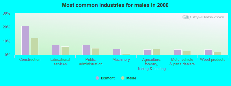
- Construction (20.9%)
- Educational services (7.2%)
- Public administration (7.2%)
- Machinery (4.3%)
- Agriculture, forestry, fishing & hunting (4.0%)
- Motor vehicle & parts dealers (4.0%)
- Wood products (4.0%)
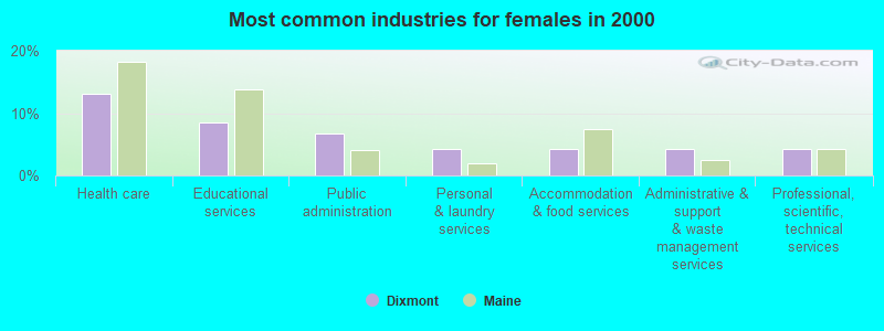
- Health care (13.1%)
- Educational services (8.4%)
- Public administration (6.8%)
- Personal & laundry services (4.2%)
- Accommodation & food services (4.2%)
- Administrative & support & waste management services (4.2%)
- Professional, scientific, technical services (4.2%)

- Driver/sales workers and truck drivers (4.7%)
- Secretaries and administrative assistants (4.3%)
- Other management occupations, except farmers and farm managers (4.1%)
- Other office and administrative support workers, including supervisors (4.1%)
- Material recording, scheduling, dispatching, and distributing workers (3.9%)
- Other sales and related occupations, including supervisors (3.7%)
- Other production occupations, including supervisors (3.5%)
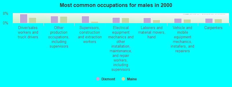
- Driver/sales workers and truck drivers (7.6%)
- Other production occupations, including supervisors (5.8%)
- Supervisors, construction and extraction workers (5.8%)
- Electrical equipment mechanics and other installation, maintenance, and repair workers, including supervisors (4.7%)
- Laborers and material movers, hand (4.3%)
- Vehicle and mobile equipment mechanics, installers, and repairers (4.0%)
- Carpenters (4.0%)
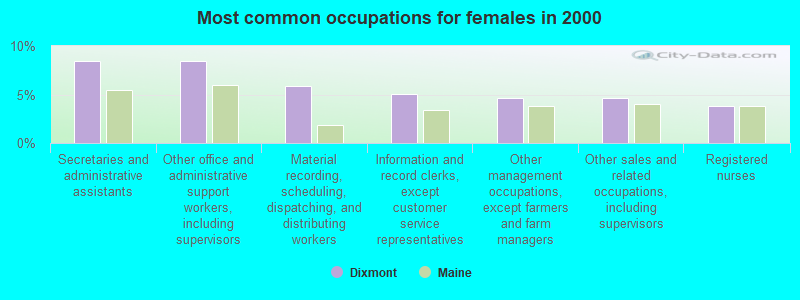
- Secretaries and administrative assistants (8.4%)
- Other office and administrative support workers, including supervisors (8.4%)
- Material recording, scheduling, dispatching, and distributing workers (5.9%)
- Information and record clerks, except customer service representatives (5.1%)
- Other management occupations, except farmers and farm managers (4.6%)
- Other sales and related occupations, including supervisors (4.6%)
- Registered nurses (3.8%)
Average climate in Dixmont, Maine
Based on data reported by over 4,000 weather stations


(lower is better)
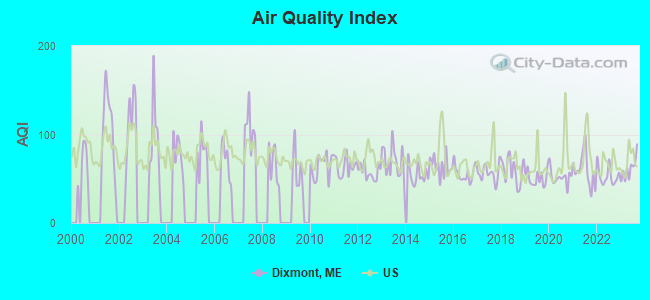
Air Quality Index (AQI) level in 2023 was 61.1. This is about average.
| City: | 61.1 |
| U.S.: | 72.6 |
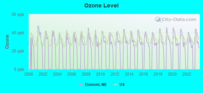
Ozone [ppb] level in 2023 was 33.6. This is about average. Closest monitor was 7.7 miles away from the city center.
| City: | 33.6 |
| U.S.: | 33.3 |
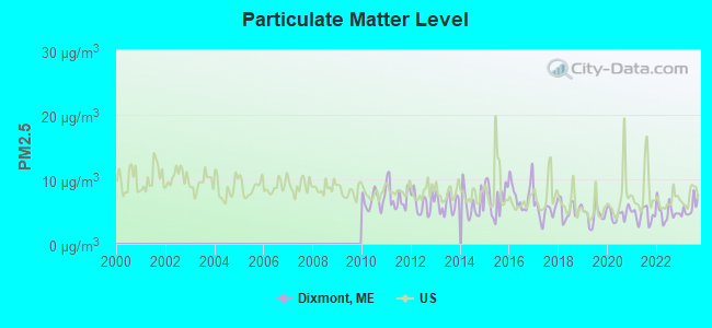
Particulate Matter (PM2.5) [µg/m3] level in 2023 was 5.62. This is significantly better than average. Closest monitor was 19.0 miles away from the city center.
| City: | 5.62 |
| U.S.: | 8.11 |
Earthquake activity:
Dixmont-area historical earthquake activity is significantly above Maine state average. It is 79% smaller than the overall U.S. average.On 4/20/2002 at 10:50:47, a magnitude 5.3 (5.3 ML, Depth: 3.0 mi, Class: Moderate, Intensity: VI - VII) earthquake occurred 225.5 miles away from Dixmont center
On 10/16/2012 at 23:12:25, a magnitude 4.7 (4.7 ML, Depth: 10.0 mi, Class: Light, Intensity: IV - V) earthquake occurred 107.2 miles away from Dixmont center
On 4/20/2002 at 10:50:47, a magnitude 5.2 (5.2 MB, 4.2 MS, 5.2 MW, 5.0 MW) earthquake occurred 226.7 miles away from the city center
On 10/7/1983 at 10:18:46, a magnitude 5.3 (5.1 MB, 5.3 LG, 5.1 ML) earthquake occurred 263.1 miles away from the city center
On 1/19/1982 at 00:14:42, a magnitude 4.7 (4.5 MB, 4.7 MD, 4.5 LG) earthquake occurred 147.9 miles away from the city center
On 2/26/1999 at 03:38:43, a magnitude 3.8 (3.8 LG, Depth: 2.0 mi, Class: Light, Intensity: II - III) earthquake occurred 24.3 miles away from Dixmont center
Magnitude types: regional Lg-wave magnitude (LG), body-wave magnitude (MB), duration magnitude (MD), local magnitude (ML), surface-wave magnitude (MS), moment magnitude (MW)
Natural disasters:
The number of natural disasters in Penobscot County (19) is greater than the US average (15).Major Disasters (Presidential) Declared: 11
Emergencies Declared: 7
Causes of natural disasters: Floods: 9, Storms: 8, Snows: 5, Heavy Rains: 2, Blizzard: 1, Hurricane: 1, Ice Storm: 1, Snowfall: 1, Wind: 1, Winter Storm: 1, Other: 2 (Note: some incidents may be assigned to more than one category).
Hospitals and medical centers near Dixmont:
Colleges/universities with over 2000 students nearest to Dixmont:
- Husson University (about 19 miles; Bangor, ME; Full-time enrollment: 2,421)
- University of Maine (about 27 miles; Orono, ME; FT enrollment: 8,931)
- University of Maine at Augusta (about 42 miles; Augusta, ME; FT enrollment: 3,204)
- University of Maine at Farmington (about 51 miles; Farmington, ME; FT enrollment: 2,036)
- Saint Joseph's College of Maine (about 90 miles; Standish, ME; FT enrollment: 2,010)
- Southern Maine Community College (about 91 miles; South Portland, ME; FT enrollment: 4,666)
- University of Southern Maine (about 92 miles; Portland, ME; FT enrollment: 6,647)
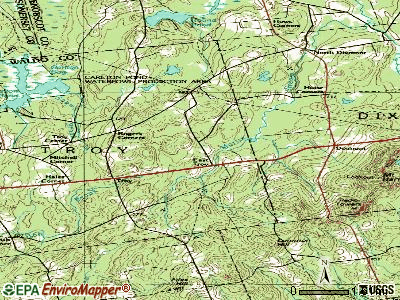
Points of interest:
Notable locations in Dixmont: Huise Corners (A), Simpson Corners (B), Dixmont Volunteer Fire Department North Station (C), Dixmont Volunteer Fire Department East Dixmont Station (D), Community Ambulance Service (E), Hog Hill (F), Dixmont Volunteer Fire Department Main Station (G). Display/hide their locations on the map
Church in Dixmont: Dixmont Corner Church (A). Display/hide its location on the map
Cemeteries: Stephen Cemetery (1), Simpson Corners Cemetery (2), Porter Cemetery (3), Mudgett Cemetery (4), Monk Cemetery (5), Jewel Cemetery (6), Dixmont Corner Cemetery (7). Display/hide their locations on the map
Lakes and swamps: Center Pond (A), Wellmans Pond (B), Skinner Bog (C), Cates Meadows (D), Chase Bog (E). Display/hide their locations on the map
Streams, rivers, and creeks: Olney Brook (A), Folsom Brook (B). Display/hide their locations on the map
Birthplace of: Levi S. Gould - Politician.
| This town: | 2.4 people |
| Maine: | 2.3 people |
| This town: | 71.1% |
| Whole state: | 62.9% |
| This town: | 8.2% |
| Whole state: | 9.4% |
Likely homosexual households (counted as self-reported same-sex unmarried-partner households)
- Lesbian couples: 0.8% of all households
- Gay men: 0.0% of all households
| This town: | 16.1% |
| Whole state: | 10.9% |
| This town: | 5.0% |
| Whole state: | 4.1% |
For population 15 years and over in Dixmont:
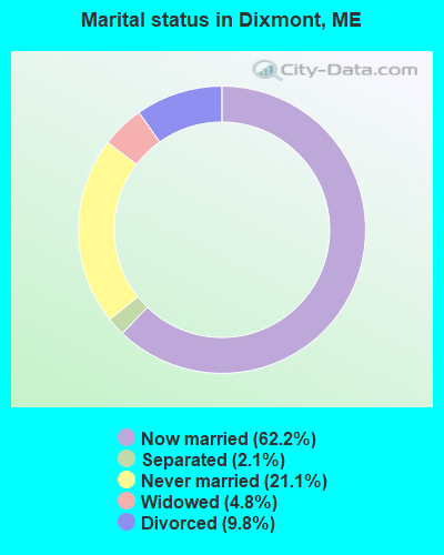
- Never married: 21.1%
- Now married: 62.2%
- Separated: 2.1%
- Widowed: 4.8%
- Divorced: 9.8%
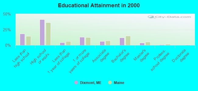
For population 25 years and over in Dixmont:
- High school or higher: 81.7%
- Bachelor's degree or higher: 16.6%
- Graduate or professional degree: 4.6%
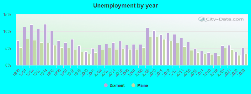
- Unemployed: 6.4%
- Mean travel time to work (commute): 33.1 minutes
| Here: | 10.9 |
| Maine average: | 11.2 |


Graphs represent county-level data. Detailed 2008 Election Results
Religion statistics for Dixmont, ME (based on Penobscot County data)


| Religion | Adherents | Congregations |
|---|---|---|
| Catholic | 16,581 | 15 |
| Mainline Protestant | 9,715 | 59 |
| Evangelical Protestant | 7,523 | 80 |
| Other | 2,936 | 22 |
| Orthodox | 300 | 1 |
| None | 116,868 | - |
Food Environment Statistics:
| Penobscot County: | 2.29 / 10,000 pop. |
| Maine: | 2.80 / 10,000 pop. |
| This county: | 0.13 / 10,000 pop. |
| Maine: | 0.14 / 10,000 pop. |
| Here: | 2.56 / 10,000 pop. |
| Maine: | 2.20 / 10,000 pop. |
| This county: | 5.72 / 10,000 pop. |
| Maine: | 5.75 / 10,000 pop. |
| Penobscot County: | 7.41 / 10,000 pop. |
| Maine: | 11.02 / 10,000 pop. |
| This county: | 9.0% |
| Maine: | 8.2% |
| Penobscot County: | 28.0% |
| Maine: | 25.0% |
Strongest AM radio stations in Dixmont:
- WZON (620 AM; 5 kW; BANGOR, ME; Owner: THE ZONE CORPORATION)
- WABI (910 AM; 5 kW; BANGOR, ME; Owner: CLEAR CHANNEL BROADCASTING LICENSES, INC.)
- WSKW (1160 AM; 10 kW; SKOWHEGAN, ME; Owner: MOUNTAIN WIRELESS, INCORPORATED)
- WDEA (1370 AM; 5 kW; ELLSWORTH, ME; Owner: CUMULUS LICENSING CORP.)
- WTME (780 AM; 10 kW; RUMFORD, ME; Owner: MOUNTAIN VALLEY BROADCASTING, INC.)
- WRKO (680 AM; 50 kW; BOSTON, MA; Owner: ENTERCOM BOSTON LICENSE, LLC)
- WFAU (1280 AM; 5 kW; GARDINER, ME; Owner: CAPSTAR TX LIMITED PARTNERSHIP)
- WEEI (850 AM; 50 kW; BOSTON, MA; Owner: ENTERCOM BOSTON LICENSE, LLC)
- WBZ (1030 AM; 50 kW; BOSTON, MA; Owner: INFINITY BROADCASTING OPERATIONS, INC.)
- WNZS (1340 AM; 1 kW; VEAZIE, ME; Owner: WATERFRONT COMMUNICATIONS INC.)
- WCRN (830 AM; 50 kW; WORCESTER, MA; Owner: CARTER BROADCASTING CORPORATION)
- WNNZ (640 AM; 50 kW; WESTFIELD, MA; Owner: CLEAR CHANNEL BROADCASTING LICENSES, INC.)
- WMTW (870 AM; 10 kW; GORHAM, ME; Owner: RADIO PARTNERS OF MAINE, L.P.)
Strongest FM radio stations in Dixmont:
- WWBX (97.1 FM; BANGOR, ME; Owner: CLEAR CHANNEL BROADCASTING LICENSES, INC.)
- WBFB (104.7 FM; BELFAST, ME; Owner: CLEAR CHANNEL BROADCASTING LICENSES, INC.)
- WKIT-FM (100.3 FM; BREWER, ME; Owner: THE ZONE CORPORATION)
- WFZX (101.7 FM; SEARSPORT, ME; Owner: CLEAR CHANNEL BROADCASTING LICENSES, INC.)
- WQCB (106.5 FM; BREWER, ME; Owner: CUMULUS LICENSING CORP.)
- WWMJ (95.7 FM; ELLSWORTH, ME; Owner: CUMULUS LICENSING CORP.)
- WMEP (90.5 FM; CAMDEN, ME; Owner: MAINE PUBLIC BROADCASTING CORP.)
- WQSS (102.5 FM; CAMDEN, ME; Owner: CLEAR CHANNEL BROADCASTING LICENSES, INC.)
- WMEH (90.9 FM; BANGOR, ME; Owner: MAINE PUBLIC BROADCASTING CORPORATION)
- WVOM (103.9 FM; HOWLAND, ME; Owner: CLEAR CHANNEL BROADCASTING LICENSES, INC.)
- WTOS-FM (105.1 FM; SKOWHEGAN, ME; Owner: CAPSTAR TX LIMITED PARTNERSHIP)
- WGUY (102.1 FM; DEXTER, ME; Owner: CONCORD MEDIA GROUP, INC.)
- WEZQ (92.9 FM; BANGOR, ME; Owner: CUMULUS LICENSING CORP.)
- WHCF (88.5 FM; BANGOR, ME; Owner: BANGOR BAPTIST CHURCH)
- WJCX (99.5 FM; PITTSFIELD, ME; Owner: CSN INTERNATIONAL)
- WERU-FM (89.9 FM; BLUE HILL, ME; Owner: SALT POND COMMUNITY B/C COMPANY)
- WCTB (93.5 FM; FAIRFIELD, ME; Owner: MOUNTAIN WIRELESS, INC.)
- WWWA (95.3 FM; WINSLOW, ME; Owner: LIGHT OF LIFE MINISTRIES, INC.)
- WHQO (107.9 FM; SKOWHEGAN, ME; Owner: MOUNTAIN WIRELESS, INC.)
- WBZN (107.3 FM; OLD TOWN, ME; Owner: CUMULUS LICENSING CORP.)
TV broadcast stations around Dixmont:
- WABI-TV (Channel 5; BANGOR, ME; Owner: COMMUNITY BROADCASTING SERVICE)
- W36CK (Channel 36; BANGOR, ME; Owner: TRINITY BROADCASTING NETWORK)
- WCKD-LP (Channel 30; BANGOR/DEDHAM, ME; Owner: J. MCLEOD, ME FAMILY B/CING., INC.)
- WLBZ (Channel 2; BANGOR, ME; Owner: PACIFIC AND SOUTHERN COMPANY, INC.)
- WBGR-LP (Channel 33; BANGOR/DEDHAM, ME; Owner: MAINE FAMILY BROADCASTING, INC.)
- WMEB-TV (Channel 12; ORONO, ME; Owner: MAINE PUBLIC BROADCASTING CORPORATION)
- Dixmont, Maine
- Fatal accident count12
- Vehicles involved in fatal accidents16
- Fatal accidents involving drunk persons:2
- Fatalities13
- Persons involved in fatal accidents27
- Pedestrians involved in fatal accidents3
- Maine average
- Fatal accident count1441
- Vehicles involved in fatal accidents2053
- Fatal accidents involving drunk persons578
- Fatalities1601
- Persons involved in fatal accidents3485
- Pedestrians involved in fatal accidents87
- National Bridge Inventory (NBI) Statistics
- 2Number of bridges
- 10ft / 3.4mTotal length
- 1,447Total average daily traffic
- 72Total average daily truck traffic
- 2,205Total future (year 2036) average daily traffic
FCC Registered Antenna Towers:
29 (See the full list of FCC Registered Antenna Towers in Dixmont)FCC Registered Commercial Land Mobile Towers:
1 (See the full list of FCC Registered Commercial Land Mobile Towers in Dixmont, ME)FCC Registered Private Land Mobile Towers:
1 (See the full list of FCC Registered Private Land Mobile Towers)FCC Registered Broadcast Land Mobile Towers:
6 (See the full list of FCC Registered Broadcast Land Mobile Towers)FCC Registered Microwave Towers:
16 (See the full list of FCC Registered Microwave Towers in this town)FCC Registered Paging Towers:
5 (See the full list of FCC Registered Paging Towers)FCC Registered Amateur Radio Licenses:
7- Call Sign: N1XMX, Licensee ID: L00270577, Grant Date: 03/22/2016, Expiration Date: 06/05/2026, Certifier: Mike Foster, Registrant: Mike Foster, Dixmont, ME 04932
- Call Sign: N3LGN, Licensee ID: L00176908, Grant Date: 11/17/2011, Expiration Date: 01/07/2022, Cancellation Date: 01/09/2024, Registrant: Paul C Rothwell, 4318 Kennebec Rd., Dixmont, ME 04932
- Call Sign: WA1ERI, Grant Date: 03/25/1996, Expiration Date: 03/25/2006, Cancellation Date: 03/26/2008, Registrant: William P Hamernick, Garland Rd, Dixmont, ME 04932
- Call Sign: KB1ITR, Licensee ID: L00571277, Grant Date: 12/07/2022, Expiration Date: 12/07/2032, Certifier: Matthew V Harzewski, Registrant: Matthew V Harzewski, 306 Moosehead Trl, Dixmont, ME 04932
- Call Sign: KC1IPY, Licensee ID: L02146289, Grant Date: 11/28/2017, Expiration Date: 11/28/2027, Cancellation Date: 12/13/2017, Certifier: Randall S Fairman, Registrant: Randall S Fairman, 4219 Kennebec Road, Dixmont, ME 04932
- Call Sign: AC1EA, Previous Call Sign: KC1IPY, Licensee ID: L02146289, Grant Date: 11/28/2017, Expiration Date: 11/28/2027, Certifier: Randall S Fairman, Registrant: Randall S Fairman, 4219 Kennebec Road, Dixmont, ME 04932
- Call Sign: K1NKX, Previous Call Sign: K1WME, Licensee ID: L01864437, Grant Date: 05/29/2019, Expiration Date: 05/29/2029, Certifier: Timothy E Clark, Registrant: Timothy E Clark, 197 Mitchell Rd, Dixmont, ME 04932
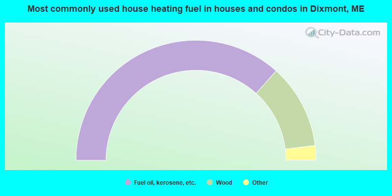
- 73.3%Fuel oil, kerosene, etc.
- 22.8%Wood
- 2.2%Bottled, tank, or LP gas
- 1.7%Electricity
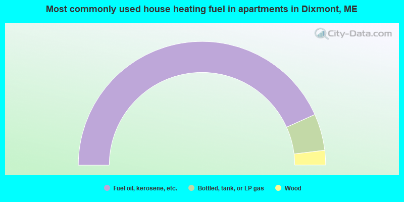
- 86.5%Fuel oil, kerosene, etc.
- 9.6%Bottled, tank, or LP gas
- 3.8%Wood
Dixmont compared to Maine state average:
- Unemployed percentage below state average.
- Black race population percentage significantly below state average.
- Hispanic race population percentage below state average.
- Foreign-born population percentage significantly below state average.
- Renting percentage significantly below state average.
- Length of stay since moving in significantly above state average.
- Number of rooms per house significantly below state average.
- House age significantly below state average.
- Percentage of population with a bachelor's degree or higher below state average.