Ewa, Hawaii

Ewa: *Sunset at the Bush*aka*Habush* Ewa Beach, Hawaii.
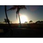
Ewa: *Sunset at the Bush*aka*Habush* Ewa Beach, Hawaii.
Ewa: Ocean Pointe, Ewa Beach, Hawaii
- add
your
Submit your own pictures of this place and show them to the world
- OSM Map
- General Map
- Google Map
- MSN Map

| Males: 142,479 | |
| Females: 137,204 |
| Median resident age: | 33.9 years |
| Hawaii median age: | 36.2 years |
Zip code: 96797
| Ewa: | $115,405 |
| HI: | $92,458 |
Estimated per capita income in 2022: $41,769 (it was $21,070 in 2000)
Ewa CCD income, earnings, and wages data
Estimated median house or condo value in 2022: $781,827 (it was $245,500 in 2000)
| Ewa: | $781,827 |
| HI: | $820,100 |
Mean prices in 2022: all housing units: $999,130; detached houses: over $1,000,000; townhouses or other attached units: $982,127; in 2-unit structures: $920,464; in 3-to-4-unit structures: $717,340; in 5-or-more-unit structures: $577,655; mobile homes: over $1,000,000; occupied boats, rvs, vans, etc.: $319,807
Detailed information about poverty and poor residents in Ewa, HI


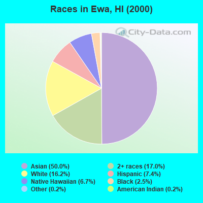
- 136,11050.0%Asian alone
- 46,35717.0%Two or more races
- 44,08616.2%White alone
- 20,0297.4%Hispanic
- 18,1346.7%Native Hawaiian and Other
Pacific Islander alone - 6,6902.5%Black alone
- 4530.2%American Indian alone
- 4690.2%Other race alone
Races in Ewa detailed stats: ancestries, foreign born residents, place of birth
 Recent articles from our blog. Our writers, many of them Ph.D. graduates or candidates, create easy-to-read articles on a wide variety of topics.
Current Local Time: HST (no DST) time zone
Elevation: 49 feet
Land area: 164.9 square miles.
Population density: 1,696 people per square mile (low).

| Ewa CCD: | 0.3% ($776) |
| Hawaii: | 0.3% ($765) |
Nearest city with pop. 1,000,000+: Los Angeles, CA  (2560.8 miles , pop. 3,694,820).
Nearest cities:
), ), ), ), )Latitude: 21.39 N, Longitude: 158.00 W

| Here: | 2.9% |
| Hawaii: | 2.9% |
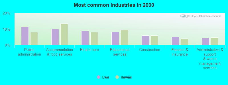
- Public administration (11.4%)
- Accommodation & food services (10.0%)
- Health care (8.8%)
- Educational services (8.2%)
- Construction (6.0%)
- Finance & insurance (5.1%)
- Administrative & support & waste management services (4.5%)
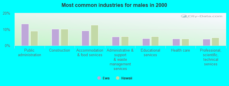
- Public administration (13.5%)
- Construction (10.2%)
- Accommodation & food services (9.2%)
- Administrative & support & waste management services (5.6%)
- Educational services (4.4%)
- Health care (4.3%)
- Professional, scientific, technical services (4.1%)
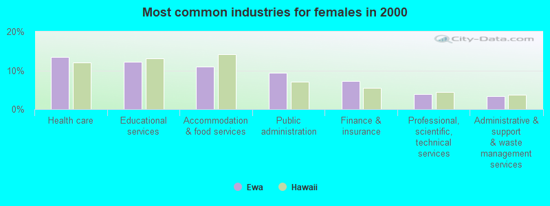
- Health care (13.5%)
- Educational services (12.2%)
- Accommodation & food services (10.9%)
- Public administration (9.3%)
- Finance & insurance (7.3%)
- Professional, scientific, technical services (3.9%)
- Administrative & support & waste management services (3.3%)
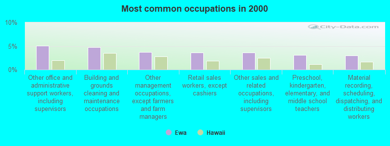
- Other office and administrative support workers, including supervisors (5.1%)
- Building and grounds cleaning and maintenance occupations (4.8%)
- Other management occupations, except farmers and farm managers (3.7%)
- Retail sales workers, except cashiers (3.6%)
- Other sales and related occupations, including supervisors (3.6%)
- Preschool, kindergarten, elementary, and middle school teachers (3.1%)
- Material recording, scheduling, dispatching, and distributing workers (3.0%)
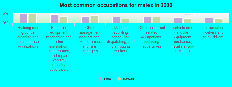
- Building and grounds cleaning and maintenance occupations (5.5%)
- Electrical equipment mechanics and other installation, maintenance, and repair workers, including supervisors (5.3%)
- Other management occupations, except farmers and farm managers (4.2%)
- Material recording, scheduling, dispatching, and distributing workers (3.7%)
- Other sales and related occupations, including supervisors (3.5%)
- Vehicle and mobile equipment mechanics, installers, and repairers (3.4%)
- Driver/sales workers and truck drivers (3.3%)
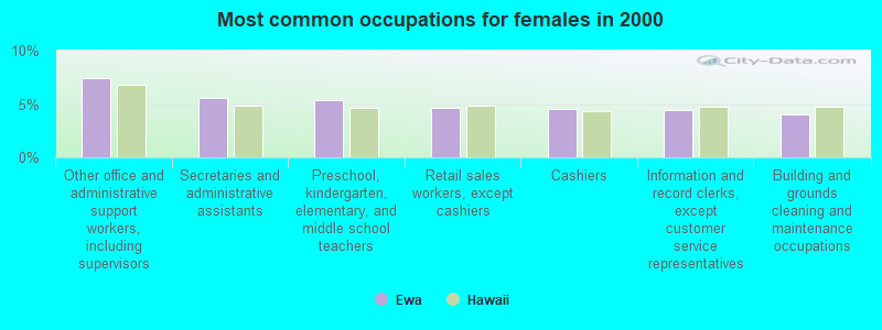
- Other office and administrative support workers, including supervisors (7.5%)
- Secretaries and administrative assistants (5.5%)
- Preschool, kindergarten, elementary, and middle school teachers (5.4%)
- Retail sales workers, except cashiers (4.7%)
- Cashiers (4.5%)
- Information and record clerks, except customer service representatives (4.4%)
- Building and grounds cleaning and maintenance occupations (4.0%)
Average climate in Ewa, Hawaii
Based on data reported by over 4,000 weather stations


(lower is better)
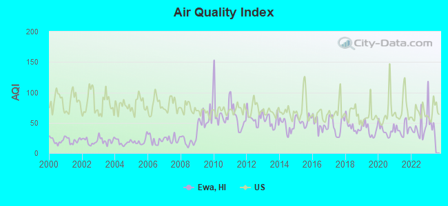
Air Quality Index (AQI) level in 2022 was 39.4. This is significantly better than average.
| City: | 39.4 |
| U.S.: | 72.6 |
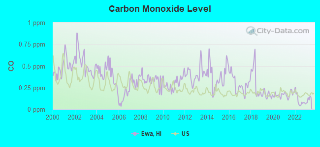
Carbon Monoxide (CO) [ppm] level in 2022 was 0.101. This is significantly better than average. Closest monitor was 7.5 miles away from the city center.
| City: | 0.101 |
| U.S.: | 0.251 |
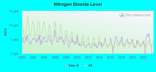
Nitrogen Dioxide (NO2) [ppb] level in 2022 was 5.88. This is about average. Closest monitor was 1.3 miles away from the city center.
| City: | 5.88 |
| U.S.: | 5.11 |

Sulfur Dioxide (SO2) [ppb] level in 2022 was 0.178. This is significantly better than average. Closest monitor was 1.3 miles away from the city center.
| City: | 0.178 |
| U.S.: | 1.515 |
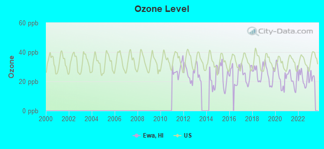
Ozone [ppb] level in 2022 was 22.1. This is significantly better than average. Closest monitor was 7.5 miles away from the city center.
| City: | 22.1 |
| U.S.: | 33.3 |
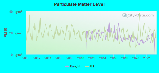
Particulate Matter (PM10) [µg/m3] level in 2022 was 14.7. This is better than average. Closest monitor was 1.9 miles away from the city center.
| City: | 14.7 |
| U.S.: | 19.2 |
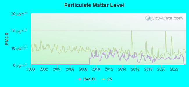
Particulate Matter (PM2.5) [µg/m3] level in 2022 was 4.12. This is significantly better than average. Closest monitor was 1.9 miles away from the city center.
| City: | 4.12 |
| U.S.: | 8.11 |
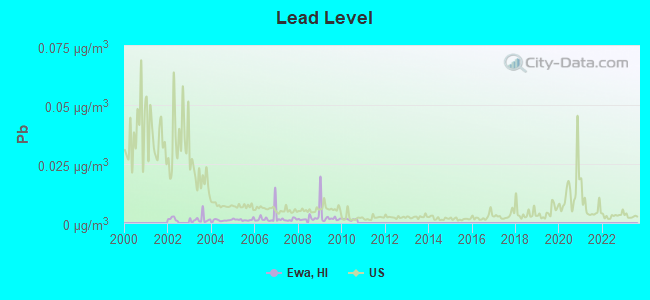
Lead (Pb) [µg/m3] level in 2010 was 0.00154. This is significantly better than average. Closest monitor was 1.9 miles away from the city center.
| City: | 0.00154 |
| U.S.: | 0.00931 |
Earthquake activity:
Ewa-area historical earthquake activity is significantly above Hawaii state average. It is 1089% greater than the overall U.S. average.On 11/29/1975 at 14:47:40, a magnitude 7.2 (6.0 MB, 7.1 MS, 7.2 UK, 7.2 MS, Class: Major, Intensity: VIII - XII) earthquake occurred 234.3 miles away from the city center, causing 2 deaths (2 shaking deaths)
On 8/21/1951 at 10:57:00, a magnitude 6.9 (6.9 UK, Class: Strong, Intensity: VII - IX) earthquake occurred 172.1 miles away from Ewa center
On 10/15/2006 at 17:07:49, a magnitude 6.7 (6.2 MB, 6.6 MS, 6.7 MW) earthquake occurred 167.7 miles away from the city center
On 10/15/2006 at 17:07:49, a magnitude 6.7 (6.7 MD, Depth: 23.7 mi) earthquake occurred 169.7 miles away from the city center
On 5/4/2018 at 22:32:54, a magnitude 6.9 (6.9 MW, Depth: 3.6 mi) earthquake occurred 241.6 miles away from Ewa center
On 11/16/1983 at 16:13:00, a magnitude 6.7 (6.4 MB, 6.7 MS, 6.7 MW) earthquake occurred 217.1 miles away from the city center, causing $6,000,000 total damage
Magnitude types: body-wave magnitude (MB), duration magnitude (MD), surface-wave magnitude (MS), moment magnitude (MW)
Natural disasters:
The number of natural disasters in Honolulu County (16) is near the US average (15).Major Disasters (Presidential) Declared: 10
Emergencies Declared: 1
Causes of natural disasters: Floods: 7, Storms: 7, Fires: 3, Mudslides: 3, Landslides: 2, Earthquake: 1, Flash Flood: 1, Heavy Rain: 1, Hurricane: 1, Tsunami Wave: 1, Typhoon: 1, Other: 1 (Note: some incidents may be assigned to more than one category).
Hospitals and medical centers near Ewa:
- PEARL CITY NURSING HOME (Nursing Home, about 2 miles away; PEARL CITY, HI)
- KAHI MOHALA (Hospital, about 3 miles away; EWA BEACH, HI)
- WAIMANO TRAINING SCHOOL AND HOSPITAL (Nursing Home, about 4 miles away; PEARL CITY, HI)
- KAISER FOUNDATION HOSPITAL Acute Care Hospitals (about 7 miles away; HONOLULU, HI)
- KFH - MALAMA 'OHANA NURSING AND REHAB CENTER (Nursing Home, about 7 miles away; HONOLULU, HI)
- MALAMA OHANA SCF (Nursing Home, about 7 miles away; HONOLULU, HI)
- PRIME CARE SERVICES HAWAII INC (Home Health Center, about 7 miles away; HONOLULU, HI)
Colleges/universities with over 2000 students nearest to Ewa:
- Leeward Community College (about 1 miles; Pearl City, HI; Full-time enrollment: 4,589)
- Honolulu Community College (about 10 miles; Honolulu, HI; FT enrollment: 2,538)
- Hawaii Pacific University (about 11 miles; Honolulu, HI; FT enrollment: 5,506)
- University of Hawaii at Manoa (about 14 miles; Honolulu, HI; FT enrollment: 16,461)
- Chaminade University of Honolulu (about 15 miles; Honolulu, HI; FT enrollment: 2,610)
- Kapiolani Community College (about 16 miles; Honolulu, HI; FT enrollment: 5,069)
- Brigham Young University-Hawaii (about 18 miles; Laie, HI; FT enrollment: 3,527)
Points of interest:
Notable locations in Ewa: Makalena Golf Course (A), Pacific Tsunami Warning Center (B), Pearl Country Club (C), Pearl Harbor Yacht Club (D), Puuloa Rifle Range (E), Keaīwa Heiau (F), Gentry Business Park (G), Hawai‘i Country Club (H), Waikele Golf Club (I), Mililani Golf Course (J), USS Arizona Memorial (K), Campbell Industrial Park (L), Waipio Peninsula Sports Complex (M), Honolulu Observatory (N), Beckoning Point Deperming Facility (O), Dry Dock Number 1 (P), Dry Dock Number 2 (Q), Dry Dock Number 3 (R), Dry Dock Number 4 (S), Hickman Field Wharf (T). Display/hide their locations on the map
Shopping Centers: Mililani Marketplace Shopping Center (1), Mililani Shopping Center (2), Mililani Town Center Shopping Center (3), Pearl City Shopping Center (4), Pearl Ridge Shopping Center (5), Waikele Shopping Center (6), Waimalu Plaza Shopping Center (7), Waipahu Shopping Plaza Shopping Center (8), Waipahu Shopping Village Shopping Center (9). Display/hide their locations on the map
Churches in Ewa include: Waipahu United Church of Christ (A), Waipahu Soto Zen Temple (B), Waipahu Seventh Day Adventist Church (C), Waipahu Samoan Assembly of God Church (D), Waipahu Hongwanji Mission (E), Aiea Hongwanji Mission (F), Waipahu Free Will Baptist Church (G), Saint Nicholas Episcopal Church (H), Aloha Jewish Chapel (I). Display/hide their locations on the map
Cemeteries: Mililani Memorial Park (1), Ewa Community Cemetery (2). Display/hide their locations on the map
Lakes, reservoirs, and swamps: Okiokiolepe Pond (A), Loko Paaiau (B), Pouhala Marsh (C). Display/hide their locations on the map
Streams, rivers, and creeks: Waikakalaua Stream (A), Kīpapa Stream (B), Waiawa Stream (C), Waimalu Stream (D), Waimano Stream (E), Waikele Stream (F), Mānana Stream (G), Kapakahi Stream (H), Kalauao Stream (I). Display/hide their locations on the map
Parks in Ewa include: Kapolei Neighborhood Park (1), Laulani Community Park (2), Holanailii Park (3), Hokuohiahi Park (4), Kalaeloa Regional Park (5), Keaīwa Heiau State Recreation Area (6), Ewa Beach Community Park (7), Aiea Field Annex (8), USS Utah (9). Display/hide their locations on the map
Beaches: Hickam Harbor Beach (A), Ula‘ula (B), Kai Beach (C), Nimitz Beach (D), One‘ula Beach (E), Nimitz Officers Beach (F), Manners Beach (G), Kupaka (H). Display/hide their locations on the map
| This place: | 3.3 people |
| Hawaii: | 2.9 people |
| This place: | 79.2% |
| Whole state: | 68.9% |
| This place: | 6.0% |
| Whole state: | 7.3% |
Likely homosexual households (counted as self-reported same-sex unmarried-partner households)
- Lesbian couples: 0.5% of all households
- Gay men: 0.3% of all households
| This place: | 6.2% |
| Whole state: | 10.7% |
| This place: | 2.9% |
| Whole state: | 5.0% |
People in group quarters in Ewa in 2010:
- 3,411 people in military ships
- 1,254 people in military barracks and dormitories (nondisciplinary)
- 1,203 people in state prisons
- 754 people in emergency and transitional shelters (with sleeping facilities) for people experiencing homelessness
- 701 people in nursing facilities/skilled-nursing facilities
- 351 people in workers' group living quarters and job corps centers
- 349 people in group homes intended for adults
- 111 people in other noninstitutional facilities
- 78 people in residential treatment centers for adults
- 60 people in mental (psychiatric) hospitals and psychiatric units in other hospitals
- 27 people in military disciplinary barracks and jails
- 23 people in in-patient hospice facilities
- 22 people in maritime/merchant vessels
- 21 people in group homes for juveniles (non-correctional)
- 12 people in residential treatment centers for juveniles (non-correctional)
- 11 people in correctional residential facilities
People in group quarters in Ewa in 2000:
- 2,487 people in military ships
- 1,720 people in military barracks, etc.
- 1,487 people in state prisons
- 712 people in other group homes
- 371 people in homes for the mentally ill
- 251 people in homes for the mentally retarded
- 184 people in other noninstitutional group quarters
- 172 people in homes for the physically handicapped
- 161 people in nursing homes
- 86 people in wards in general hospitals for patients who have no usual home elsewhere
- 55 people in hospitals or wards for drug/alcohol abuse
- 38 people in religious group quarters
- 21 people in hospitals/wards and hospices for chronically ill
- 20 people in hospices or homes for chronically ill
- 19 people in homes or halfway houses for drug/alcohol abuse
- 19 people in other nonhousehold living situations
- 17 people in military transient quarters for temporary residents
- 13 people in agriculture workers' dormitories on farms
- 11 people in schools, hospitals, or wards for the intellectually disabled
- 9 people in unknown juvenile institutions
- 6 people in crews of maritime vessels
- 5 people in mental (psychiatric) hospitals or wards
- 2 people in other workers' dormitories
For population 15 years and over in Ewa:
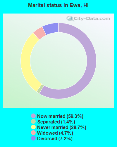
- Never married: 28.7%
- Now married: 59.3%
- Separated: 1.4%
- Widowed: 4.7%
- Divorced: 7.2%
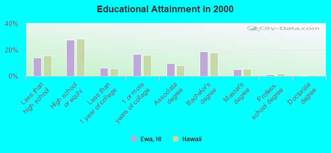
For population 25 years and over in Ewa:
- High school or higher: 85.9%
- Bachelor's degree or higher: 25.1%
- Graduate or professional degree: 6.6%
- Unemployed: 5.4%
- Mean travel time to work (commute): 30.5 minutes
| Here: | 12.2 |
| Hawaii average: | 12.8 |
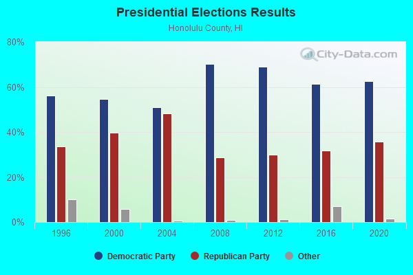
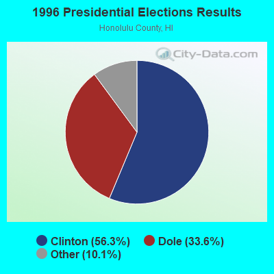
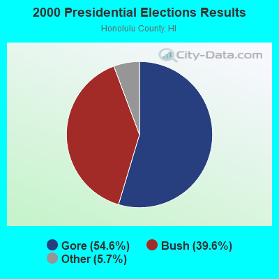
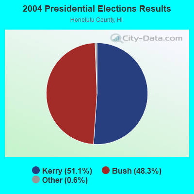
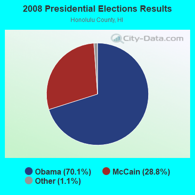
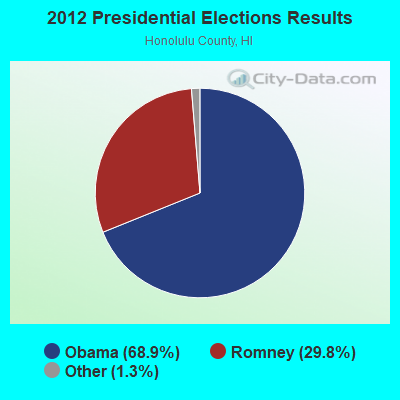
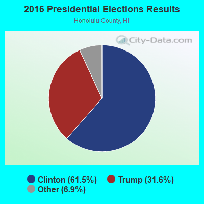
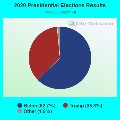
Graphs represent county-level data. Detailed 2008 Election Results
Religion statistics for Ewa, HI (based on Honolulu County data)
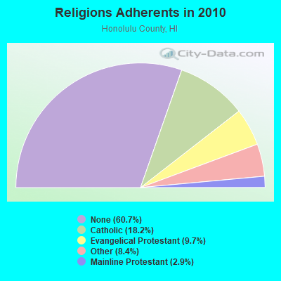
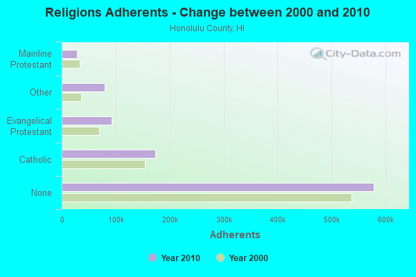
| Religion | Adherents | Congregations |
|---|---|---|
| Catholic | 173,716 | 39 |
| Evangelical Protestant | 92,310 | 382 |
| Other | 80,221 | 204 |
| Mainline Protestant | 28,013 | 115 |
| Orthodox | 300 | 4 |
| None | 578,647 | - |
Food Environment Statistics:
| Honolulu County: | 2.17 / 10,000 pop. |
| Hawaii: | 2.30 / 10,000 pop. |
| This county: | 0.10 / 10,000 pop. |
| State: | 0.09 / 10,000 pop. |
| Honolulu County: | 1.40 / 10,000 pop. |
| Hawaii: | 1.57 / 10,000 pop. |
| Honolulu County: | 1.57 / 10,000 pop. |
| State: | 1.72 / 10,000 pop. |
| Here: | 8.15 / 10,000 pop. |
| State: | 9.00 / 10,000 pop. |
| This county: | 8.3% |
| Hawaii: | 8.1% |
| Honolulu County: | 20.5% |
| Hawaii: | 20.8% |
| This county: | 8.9% |
| State: | 9.2% |
4.80% of this county's 2021 resident taxpayers lived in other counties in 2020 ($72,704 average adjusted gross income)
| Here: | 4.80% |
| Hawaii average: | 4.91% |
0.27% of residents moved from foreign countries ($4,064 average AGI)
Honolulu County: 0.27% Hawaii average: 0.19%
Top counties from which taxpayers relocated into this county between 2020 and 2021:
| from San Diego County, CA | |
| from Los Angeles County, CA | |
| from Hawaii County, HI |
5.90% of this county's 2020 resident taxpayers moved to other counties in 2021 ($71,643 average adjusted gross income)
| Here: | 5.90% |
| Hawaii average: | 5.53% |
0.21% of residents moved to foreign countries ($2,928 average AGI)
Honolulu County: 0.21% Hawaii average: 0.15%
Top counties to which taxpayers relocated from this county between 2020 and 2021:
| to Clark County, NV | |
| to San Diego County, CA | |
| to Hawaii County, HI |
Strongest AM radio stations in Ewa:
- KHNR (650 AM; 10 kW; HONOLULU, HI; Owner: SALEM MEDIA OF HAWAII, INC.)
- KJPN (1370 AM; 6 kW; PEARL CITY, HI; Owner: DIAMOND BROADCASTING CORPORATION)
- KHCM (940 AM; 10 kW; WAIPAHU, HI; Owner: SALEM MEDIA OF HAWAII, INC.)
- KLHT (1040 AM; 10 kW; HONOLULU, HI; Owner: CALVARY CHAPEL OF HONOLULU, INC.)
- KSSK (590 AM; 8 kW; HONOLULU, HI; Owner: CAPSTAR TX LIMITED PARTNERSHIP)
- KHVH (830 AM; 10 kW; HONOLULU, HI; Owner: CAPSTAR TX LIMITED PARTNERSHIP)
- KORL (690 AM; 10 kW; HONOLULU, HI; Owner: NEW WAVE BROADCASTING, L.P.)
- KUMU (1500 AM; 10 kW; HONOLULU, HI; Owner: MAVERICK MEDIA OF OAHU LICENSE LLC)
- KGU (760 AM; 10 kW; HONOLULU, HI; Owner: SALEM MEDIA OF HAWAII, INC.)
- KHBZ (990 AM; 5 kW; HONOLULU, HI; Owner: CAPSTAR TX LIMITED PARTNERSHIP)
- KNDI (1270 AM; 5 kW; HONOLULU, HI; Owner: BROADCAST HOUSE OF THE PACIFIC INC.)
- KKEA (1420 AM; 5 kW; HONOLULU, HI; Owner: BLOW UP, LLC)
- KREA (1540 AM; 5 kW; HONOLULU, HI; Owner: JMK COMMUNICATIONS,INC.)
Strongest FM radio stations in Ewa:
- KAIM-FM (95.5 FM; HONOLULU, HI; Owner: SALEM MEDIA OF HAWAII, INC.)
- KSSK-FM (92.3 FM; WAIPAHU, HI; Owner: CAPSTAR TX LIMITED PARTNERSHIP)
- KAHA (105.9 FM; HONOLULU, HI; Owner: KASA MOKU KA PAWA BROADCASTING, INC.)
- KCCN-FM (100.3 FM; HONOLULU, HI; Owner: CXR HOLDINGS, INC.)
- KGMZ-FM (107.9 FM; AIEA, HI; Owner: HONOLULU BROADCASTING, INC.)
- KINE-FM (105.1 FM; HONOLULU, HI; Owner: CXR HOLDINGS, INC.)
- KUCD (101.9 FM; PEARL CITY, HI; Owner: CAPSTAR TX LIMITED PARTNERSHIP)
- KDDB (102.7 FM; WAIPAHU, HI; Owner: NEW WAVE BROADCASTING, L.P.)
- KPOI-FM (97.5 FM; HONOLULU, HI; Owner: NEW WAVE BROADCASTING, L.P.)
- KIPO (89.3 FM; HONOLULU, HI; Owner: HAWAII PUBLIC RADIO)
- KQMQ-FM (93.1 FM; HONOLULU, HI; Owner: NEW WAVE BROADCASTING, L.P.)
- KHUI (99.5 FM; HONOLULU, HI; Owner: NEW WAVE BROADCASTING, L.P.)
- KXME (104.3 FM; KANEOHE, HI; Owner: CXR HOLDINGS, INC.)
- KRTR-FM (96.3 FM; KAILUA, HI; Owner: CXR HOLDINGS, INC.)
- K215EH (90.9 FM; KAILUA, HI; Owner: CALVARY CHAPEL OF TWIN FALLS, INC.)
- K214CY (90.7 FM; MAILI, HI; Owner: EDUCATIONAL MEDIA FOUNDATION)
TV broadcast stations around Ewa:
- KWHE (Channel 14; HONOLULU, HI; Owner: LESEA BROADCASTING CORPORATION)
- KHON-TV (Channel 2; HONOLULU, HI; Owner: EMMIS TELEVISION LICENSE CORPORATION)
- KGMB (Channel 9; HONOLULU, HI; Owner: EMMIS TELEVISION LICENSE CORPORATION)
- KIKU (Channel 20; HONOLULU, HI; Owner: KHLS, INC.)
- KITV (Channel 4; HONOLULU, HI; Owner: KITV HEARST-ARGYLE TV, INC. (CA CORP.))
- KBFD (Channel 32; HONOLULU, HI; Owner: THE ALLEN BROADCASTING CORP.)
- KHLU-LP (Channel 60; HONOLULU, HI; Owner: HTV/HTN/HAWAIIAN TV NETWORK, LTD.)
- KHET (Channel 11; HONOLULU, HI; Owner: HAWAII PUBLIC TELEVISION FOUNDATION)
- K54EX (Channel 54; HONOLULU, HI; Owner: CRAIG ALLYN JUE)
- KAAH (Channel 26; HONOLULU, HI; Owner: TRINITY BROADCASTING NETWORK)
- KHNL (Channel 13; HONOLULU, HI; Owner: RAYCOM NATIONAL, INC.)
- KFVE (Channel 5; HONOLULU, HI; Owner: RAYCOM NATIONAL, INC.)
- KALO (Channel 38; HONOLULU, HI; Owner: PACIFICA BROADCASTING COMPANY)
- KWBN (Channel 44; HONOLULU, HI; Owner: HO'ONA'AUAO COMMUNITY TV, INC.)
- KHHI-LP (Channel 48; HONOLULU, HI; Owner: EQUITY BROADCASTING CORPORATION)
- K42CO (Channel 42; HONOLULU, HI; Owner: OCEANIA BROADCASTING NETWORK, INC.)
- KPXO (Channel 66; KANEOHE, HI; Owner: PAXSON HAWAII LICENSE, INC.)
- K56EX (Channel 56; HONOLULU, HI; Owner: VICTOR AGMATA, JR.)
- National Bridge Inventory (NBI) Statistics
- 2Number of bridges
- 7ft / 1.7mTotal length
- $380,000Total costs
- 12,932Total average daily traffic
- 16,165Total future (year 2025) average daily traffic
FCC Registered Antenna Towers:
30 (See the full list of FCC Registered Antenna Towers in Ewa)FCC Registered Private Land Mobile Towers:
1 (See the full list of FCC Registered Private Land Mobile Towers in Ewa, HI)FCC Registered Broadcast Land Mobile Towers:
9 (See the full list of FCC Registered Broadcast Land Mobile Towers)FCC Registered Microwave Towers:
5 (See the full list of FCC Registered Microwave Towers in this town)FCC Registered Paging Towers:
2 (See the full list of FCC Registered Paging Towers)FCC Registered Maritime Coast & Aviation Ground Towers:
1 (See the full list of FCC Registered Maritime Coast & Aviation Ground Towers)FCC Registered Amateur Radio Licenses:
6- Call Sign: KH6GOZ, Grant Date: 09/30/1996, Expiration Date: 09/30/2006, Cancellation Date: 10/01/2008, Registrant: Carl L Mc Kean, 92-770 Maalili Pl, Ewa, HI 96706
- Call Sign: WH6BVS, Grant Date: 12/22/1987, Expiration Date: 12/22/1997, Cancellation Date: 12/23/1999, Registrant: Abel C Aiona, 92-365 Laahaina Pl, Ewa, HI 96707
- Call Sign: WH6BVW, Grant Date: 12/22/1987, Expiration Date: 12/22/1997, Cancellation Date: 12/23/1999, Registrant: Norina L Aiona, 92-365 Laahaina Pl, Ewa, HI 96707
- Call Sign: WH6BVY, Grant Date: 12/22/1987, Expiration Date: 12/22/1997, Cancellation Date: 12/23/1999, Registrant: Romel G Marcelino, 91-1729 Bond St, Ewa, HI 96706
- Call Sign: WH6CHV, Licensee ID: L00170704, Grant Date: 09/27/2010, Expiration Date: 12/24/2020, Cancellation Date: 12/28/2022, Certifier: Nelson Manzanillo, Registrant: Nelson Manzanillo, 91-1347 Puuhala St, Ewa, HI 96706
- Call Sign: WH6CIP, Grant Date: 08/07/1990, Expiration Date: 08/07/2000, Cancellation Date: 08/08/2002, Registrant: Nelson L Manzanillo, 91-1347 Puuhala St, Ewa, HI 96706
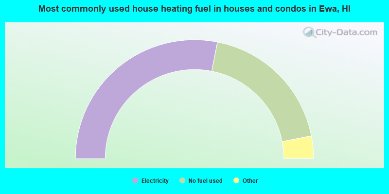
- 56.2%Electricity
- 37.7%No fuel used
- 3.5%Utility gas
- 1.7%Solar energy
- 0.7%Bottled, tank, or LP gas
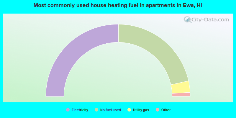
- 50.3%Electricity
- 42.9%No fuel used
- 5.1%Utility gas
- 0.9%Bottled, tank, or LP gas
- 0.9%Solar energy
Ewa compared to Hawaii state average:
- Unemployed percentage below state average.
- Median age below state average.
- Foreign-born population percentage significantly below state average.
- Length of stay since moving in significantly above state average.
- Number of rooms per house significantly below state average.
- House age significantly below state average.
Ewa, HI compared to other similar cities:
Ewa on our top lists:
- #3 on the list of "Top 101 cities with largest percentage of males in occupations: transportation, tourism, and lodging attendants (population 50,000+)"
- #4 on the list of "Top 101 cities with largest percentage of females in industries: jewelry, luggage, and leather goods stores (population 50,000+)"
- #4 on the list of "Top 101 cities with largest percentage of females in occupations: supervisors of transportation and material moving workers (population 50,000+)"
- #4 on the list of "Top 101 cities with the smallest temperature differences during a year (population 50,000+)"
- #5 on the list of "Top 101 cities with largest percentage of males in industries: department and other general merchandise stores (population 50,000+)"
- #5 on the list of "Top 101 cities with largest percentage of males in industries: air transportation (population 50,000+)"
- #6 on the list of "Top 101 cities with largest percentage of females in occupations: retail sales workers except cashiers (population 50,000+)"
- #6 on the list of "Top 101 cities with largest percentage of females in industries: air transportation (population 50,000+)"
- #7 on the list of "Top 101 cities with largest percentage of males in occupations: cooks and food preparation workers (population 50,000+)"
- #8 on the list of "Top 101 cities with largest percentage of males in occupations: other protective service workers including supervisors (population 50,000+)"
- #8 on the list of "Top 101 cities with largest percentage of males in industries: alcoholic beverages merchant wholesalers (population 50,000+)"
- #8 on the list of "Top 100 low-educated but high-earning cities (pop. 50,000+)"
- #8 on the list of "Top 101 cities with largest percentage of females in occupations: cooks and food preparation workers (population 50,000+)"
- #9 on the list of "Top 101 cities with largest percentage of males in industries: groceries and related products merchant wholesalers (population 50,000+)"
- #9 on the list of "Top 101 cities with largest percentage of females in industries: groceries and related products merchant wholesalers (population 50,000+)"
- #9 on the list of "Top 101 cities with largest percentage of females in industries: other direct selling establishments (population 50,000+)"
- #14 on the list of "Top 101 cities with largest percentage of females in industries: clothing and accessories, including shoe, stores (population 50,000+)"
- #15 on the list of "Top 101 cities with the largest percentage of people in military ships (population 1,000+)"
- #16 on the list of "Top 101 cities with largest percentage of females in industries: used merchandise, gift, novelty, and souvenir, and other miscellaneous stores (population 50,000+)"
- #17 on the list of "Top 101 cities with largest percentage of males in industries: other transportation, and support activities, and couriers (population 50,000+)"
- #94 (96797) on the list of "Top 101 zip codes with the largest percentage of Portuguese first ancestries"
- #7 on the list of "Top 101 counties with the lowest average weight of females"
- #15 on the list of "Top 101 counties with the highest ground withdrawal of fresh water for public supply"
- #21 on the list of "Top 101 counties with the most Other congregations"
- #25 on the list of "Top 101 counties with the most Other adherents"
- #25 on the list of "Top 101 counties with the highest carbon monoxide air pollution readings in 2012 (ppm)"