Fort Motte-Lone Star, South Carolina
Submit your own pictures of this place and show them to the world
- OSM Map
- Google Map
- MSN Map
| Males: 498 | |
| Females: 536 |
| Median resident age: | 43.3 years |
| South Carolina median age: | 35.4 years |
Zip code: 29135
| Fort Motte-Lone Star: | $54,507 |
| SC: | $64,115 |
Estimated per capita income in 2022: $36,678 (it was $20,369 in 2000)
Fort Motte-Lone Star CCD income, earnings, and wages data
Estimated median house or condo value in 2022: $179,841 (it was $70,700 in 2000)
| Fort Motte-Lone Star: | $179,841 |
| SC: | $254,600 |
Mean prices in 2022: all housing units: $239,267; detached houses: $292,115; townhouses or other attached units: $111,548; mobile homes: $94,500
Fort Motte-Lone Star, SC residents, houses, and apartments details
Detailed information about poverty and poor residents in Fort Motte-Lone Star, SC


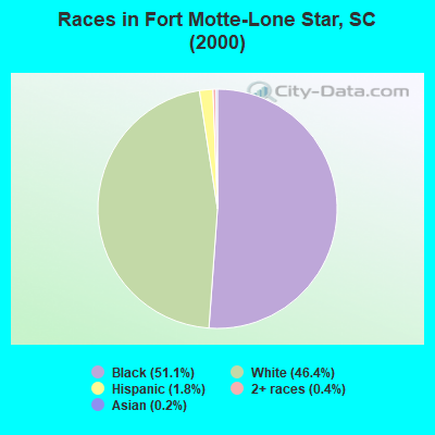
- 54551.1%Black alone
- 49546.4%White alone
- 191.8%Hispanic
- 40.4%Two or more races
- 20.2%Asian alone
- 10.09%American Indian alone
Races in Fort Motte-Lone Star detailed stats: ancestries, foreign born residents, place of birth
 Recent articles from our blog. Our writers, many of them Ph.D. graduates or candidates, create easy-to-read articles on a wide variety of topics.
Current Local Time: EST time zone
Land area: 78.7 square miles.
Population density: 13 people per square mile (very low).
| Fort Motte-Lone Star CCD: | 0.6% ($417) |
| South Carolina: | 0.6% ($510) |
Nearest city with pop. 50,000+: Columbia, SC  (31.9 miles , pop. 116,278).
Nearest city with pop. 200,000+: Charlotte, NC (106.3 miles , pop. 540,828).
Nearest city with pop. 1,000,000+: Philadelphia, PA (532.0 miles , pop. 1,517,550).
Nearest cities:
), ), ), ), ), Latitude: 33.68 N, Longitude: 80.63 W
Area code commonly used in this area: 803
| Here: | 3.2% |
| South Carolina: | 3.1% |
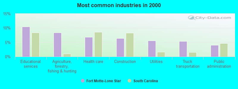
- Educational services (10.5%)
- Agriculture, forestry, fishing & hunting (8.4%)
- Health care (6.9%)
- Construction (6.4%)
- Utilities (5.6%)
- Truck transportation (5.4%)
- Public administration (4.1%)
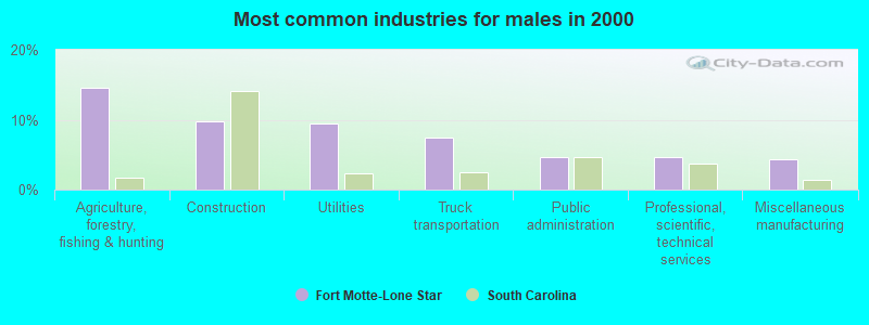
- Agriculture, forestry, fishing & hunting (14.6%)
- Construction (9.8%)
- Utilities (9.4%)
- Truck transportation (7.5%)
- Public administration (4.7%)
- Professional, scientific, technical services (4.7%)
- Miscellaneous manufacturing (4.3%)
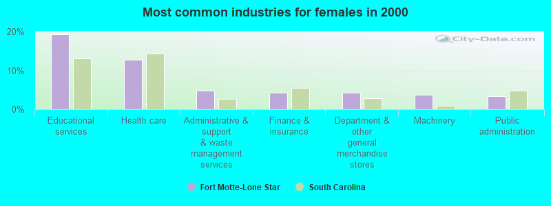
- Educational services (19.2%)
- Health care (12.7%)
- Administrative & support & waste management services (4.7%)
- Finance & insurance (4.2%)
- Department & other general merchandise stores (4.2%)
- Machinery (3.8%)
- Public administration (3.3%)
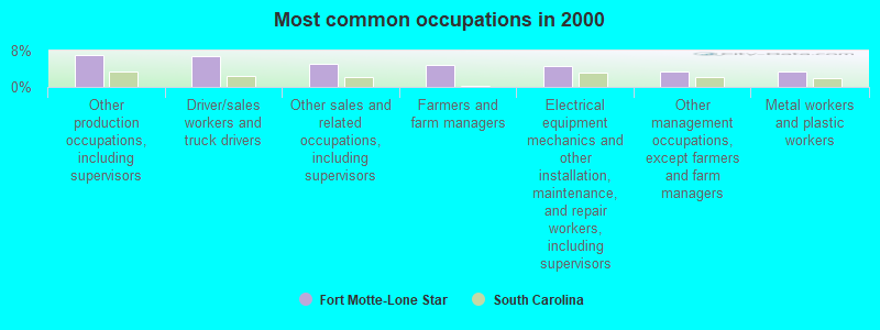
- Other production occupations, including supervisors (7.1%)
- Driver/sales workers and truck drivers (6.9%)
- Other sales and related occupations, including supervisors (5.1%)
- Farmers and farm managers (4.9%)
- Electrical equipment mechanics and other installation, maintenance, and repair workers, including supervisors (4.7%)
- Other management occupations, except farmers and farm managers (3.4%)
- Metal workers and plastic workers (3.4%)
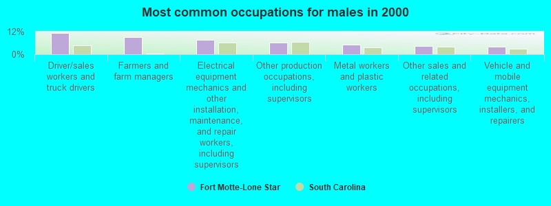
- Driver/sales workers and truck drivers (11.4%)
- Farmers and farm managers (9.1%)
- Electrical equipment mechanics and other installation, maintenance, and repair workers, including supervisors (7.5%)
- Other production occupations, including supervisors (6.3%)
- Metal workers and plastic workers (5.1%)
- Other sales and related occupations, including supervisors (4.3%)
- Vehicle and mobile equipment mechanics, installers, and repairers (3.9%)
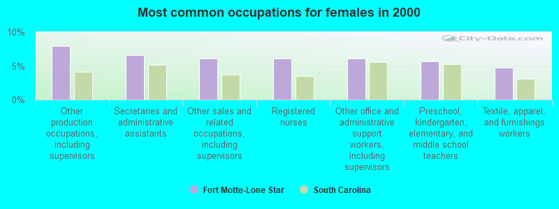
- Other production occupations, including supervisors (8.0%)
- Secretaries and administrative assistants (6.6%)
- Other sales and related occupations, including supervisors (6.1%)
- Registered nurses (6.1%)
- Other office and administrative support workers, including supervisors (6.1%)
- Preschool, kindergarten, elementary, and middle school teachers (5.6%)
- Textile, apparel, and furnishings workers (4.7%)
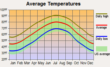
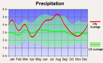
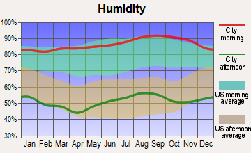
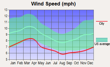
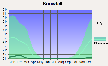
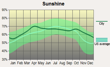
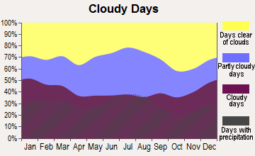
Average climate in Fort Motte-Lone Star, South Carolina
Based on data reported by over 4,000 weather stations
(lower is better)
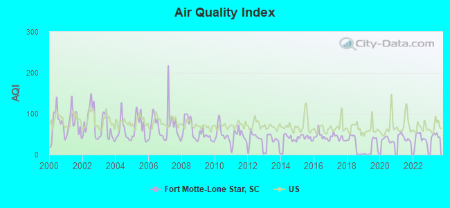
Air Quality Index (AQI) level in 2023 was 46.6. This is significantly better than average.
| City: | 46.6 |
| U.S.: | 72.6 |
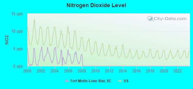
Nitrogen Dioxide (NO2) [ppb] level in 2007 was 2.17. This is significantly better than average. Closest monitor was 12.7 miles away from the city center.
| City: | 2.17 |
| U.S.: | 5.11 |
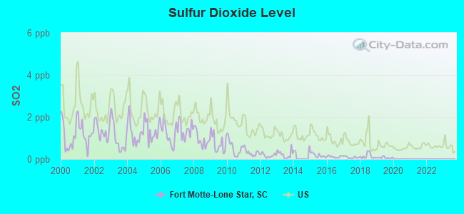
Sulfur Dioxide (SO2) [ppb] level in 2019 was 0.0671. This is significantly better than average. Closest monitor was 12.7 miles away from the city center.
| City: | 0.0671 |
| U.S.: | 1.5147 |
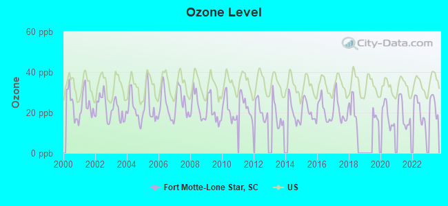
Ozone [ppb] level in 2023 was 24.2. This is better than average. Closest monitor was 12.7 miles away from the city center.
| City: | 24.2 |
| U.S.: | 33.3 |
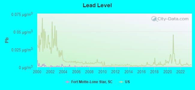
Lead (Pb) [µg/m3] level in 2007 was 0.00019. This is significantly better than average. Closest monitor was 12.7 miles away from the city center.
| City: | 0.00019 |
| U.S.: | 0.00931 |
Tornado activity:
Fort Motte-Lone Star-area historical tornado activity is slightly above South Carolina state average. It is 20% greater than the overall U.S. average.
On 4/15/2007, a category F3 (max. wind speeds 158-206 mph) tornado 10.9 miles away from the Fort Motte-Lone Star place center killed one person and injured 5 people.
On 12/10/2004, a category F3 tornado 12.1 miles away from the place center injured one person.
Earthquake activity:
Fort Motte-Lone Star-area historical earthquake activity is significantly above South Carolina state average. It is 36% smaller than the overall U.S. average.On 11/22/1974 at 05:25:55, a magnitude 4.7 (4.7 MB, Class: Light, Intensity: IV - V) earthquake occurred 60.8 miles away from the city center
On 8/2/1974 at 08:52:09, a magnitude 4.9 (4.3 MB, 4.9 LG) earthquake occurred 107.5 miles away from Fort Motte-Lone Star center
On 8/9/2020 at 12:07:37, a magnitude 5.1 (5.1 MW, Depth: 4.7 mi, Class: Moderate, Intensity: VI - VII) earthquake occurred 195.2 miles away from the city center
On 8/23/2011 at 17:51:04, a magnitude 5.8 (5.8 MW, Depth: 3.7 mi) earthquake occurred 329.4 miles away from Fort Motte-Lone Star center
On 8/21/1992 at 16:31:55, a magnitude 4.4 (4.1 MB, 4.1 LG, 4.4 LG, Depth: 6.2 mi) earthquake occurred 52.8 miles away from Fort Motte-Lone Star center
On 2/15/2014 at 03:23:38, a magnitude 4.1 (4.1 MW, Depth: 3.2 mi) earthquake occurred 84.4 miles away from the city center
Magnitude types: regional Lg-wave magnitude (LG), body-wave magnitude (MB), moment magnitude (MW)
Natural disasters:
The number of natural disasters in Calhoun County (18) is near the US average (15).Major Disasters (Presidential) Declared: 9
Emergencies Declared: 6
Causes of natural disasters: Hurricanes: 8, Floods: 3, Storms: 3, Winter Storms: 3, Drought: 1, Ice Storm: 1, Tropical Storm: 1, Other: 1 (Note: some incidents may be assigned to more than one category).
Colleges/universities with over 2000 students nearest to Fort Motte-Lone Star:
- Orangeburg Calhoun Technical College (about 15 miles; Orangeburg, SC; Full-time enrollment: 2,113)
- South Carolina State University (about 18 miles; Orangeburg, SC; FT enrollment: 3,481)
- Central Carolina Technical College (about 24 miles; Sumter, SC; FT enrollment: 3,108)
- University of South Carolina-Columbia (about 32 miles; Columbia, SC; FT enrollment: 27,789)
- Benedict College (about 33 miles; Columbia, SC; FT enrollment: 3,039)
- Midlands Technical College (about 34 miles; West Columbia, SC; FT enrollment: 8,916)
- Denmark Technical College (about 38 miles; Denmark, SC; FT enrollment: 2,050)
Points of interest:
Notable locations in Fort Motte-Lone Star: Langsyne Plantation (A), Low Falls Landing (B), Saw Dust Landing (C), Fort Motte Fire Department Lone Star (D), Fort Motte Fire Department (E). Display/hide their locations on the map
Churches in Fort Motte-Lone Star include: Red Church (A), Saint Luke Church (B), Saint Mark Church (C), Saint Paul Church (D), Savannah Chapel (E), Bethel Church (F), Cedar Falls Church (G), Haynes Chapel (H), Bethel Church (I). Display/hide their locations on the map
Cemetery: Goodin Cemetery (1). Display/hide its location on the map
Reservoirs: Campbell Pond (A), Hutto Pond (B), Huttos Lake (C), Shehane Cabin Pond (D), Reid Pond (E), Reid House Pond (F), J L Wannamaker Cabin Pond (G), Gadden Pond (H). Display/hide their locations on the map
Creeks: Squirrel Creek (A), Warley Creek (B), True Blue Creek (C), Buckhead Creek (D), Halfway Swamp Creek (E), Bates Mill Creek (F). Display/hide their locations on the map
| This place: | 2.3 people |
| South Carolina: | 2.5 people |
| This place: | 64.1% |
| Whole state: | 67.5% |
| This place: | 3.1% |
| Whole state: | 6.0% |
No gay or lesbian households reported
| This place: | 21.6% |
| Whole state: | 14.1% |
| This place: | 10.1% |
| Whole state: | 6.5% |
For population 15 years and over in Fort Motte-Lone Star:

- Never married: 23.6%
- Now married: 56.5%
- Separated: 4.7%
- Widowed: 11.7%
- Divorced: 8.2%
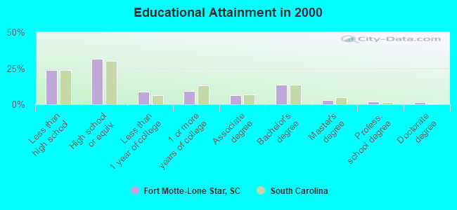
For population 25 years and over in Fort Motte-Lone Star:
- High school or higher: 76.0%
- Bachelor's degree or higher: 19.9%
- Graduate or professional degree: 6.2%
- Unemployed: 5.5%
- Mean travel time to work (commute): 33.0 minutes
| Here: | 14.8 |
| South Carolina average: | 13.2 |
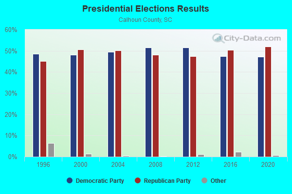
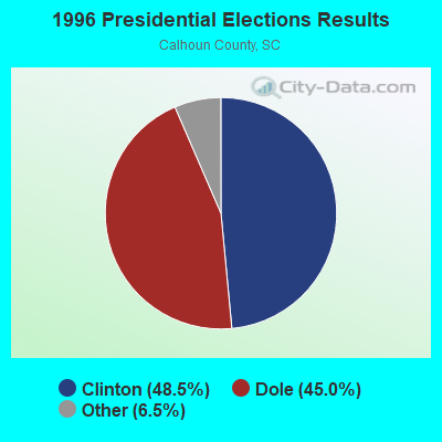
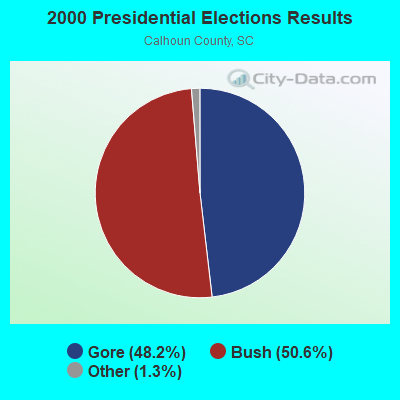
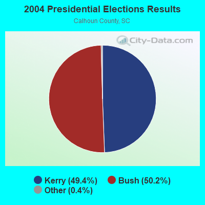
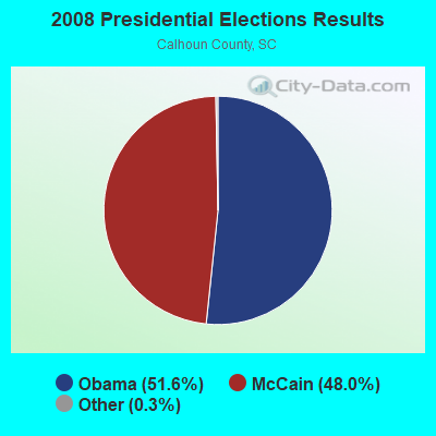
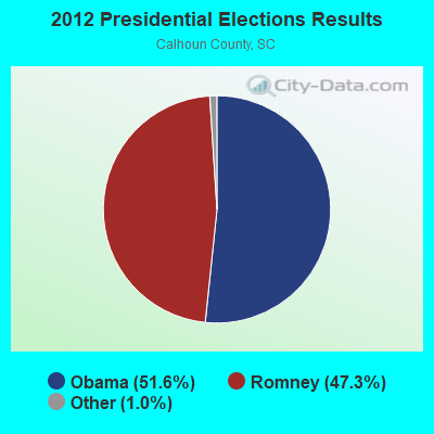
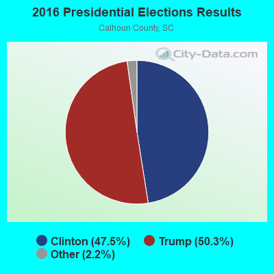
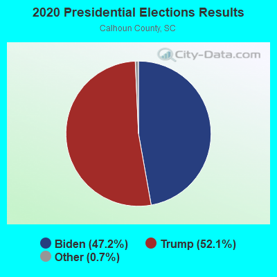
Graphs represent county-level data. Detailed 2008 Election Results
Religion statistics for Fort Motte-Lone Star, SC (based on Calhoun County data)
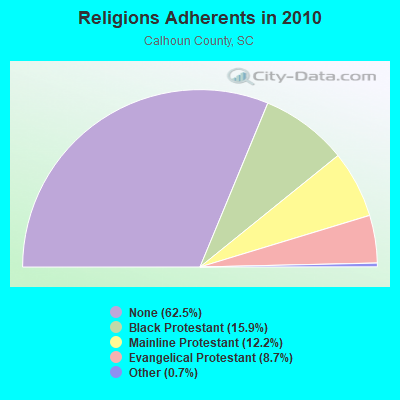
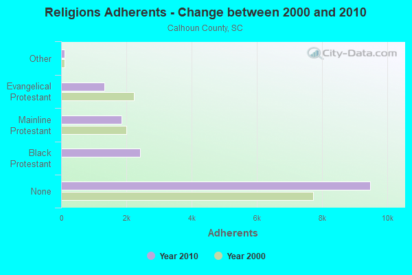
| Religion | Adherents | Congregations |
|---|---|---|
| Black Protestant | 2,411 | 15 |
| Mainline Protestant | 1,857 | 14 |
| Evangelical Protestant | 1,318 | 11 |
| Other | 106 | 1 |
| Catholic | - | - |
| None | 9,483 | - |
Food Environment Statistics:
| Calhoun County: | 0.68 / 10,000 pop. |
| South Carolina: | 1.99 / 10,000 pop. |
| Calhoun County: | 0.68 / 10,000 pop. |
| State: | 0.85 / 10,000 pop. |
| This county: | 8.82 / 10,000 pop. |
| South Carolina: | 5.38 / 10,000 pop. |
| Calhoun County: | 1.36 / 10,000 pop. |
| South Carolina: | 7.75 / 10,000 pop. |
| This county: | 13.0% |
| South Carolina: | 10.6% |
| This county: | 33.0% |
| State: | 29.4% |
| This county: | 15.6% |
| South Carolina: | 13.4% |
Strongest AM radio stations in Fort Motte-Lone Star:
- WCEO (840 AM; daytime; 50 kW; COLUMBIA, SC; Owner: EASTERN BROADCASTING GROUP, INC.)
- WBAJ (890 AM; daytime; 50 kW; BLYTHEWOOD, SC; Owner: FAMILY FIRST)
- WQKI (710 AM; daytime; 1 kW; ST. MATTHEWS, SC; Owner: MILLER COMMUNICATIONS, INC.)
- WYMB (920 AM; 2 kW; MANNING, SC; Owner: CUMULUS LICENSING CORP.)
- WVOC (560 AM; 5 kW; COLUMBIA, SC; Owner: CAPSTAR TX LIMITED PARTNERSHIP)
- WIQB (1050 AM; 25 kW; CONWAY, SC; Owner: CUMULUS LICENSING CORP.)
- WAGL (1560 AM; daytime; 50 kW; LANCASTER, SC; Owner: PALMETTO BROADCASTING SYSTEM, INC.)
- WLGO (1170 AM; daytime; 10 kW; LEXINGTON, SC; Owner: LEVAS COMMUNICATIONS, LLC)
- WQTK (950 AM; 10 kW; MONCKS CORNER, SC; Owner: KIRKMAN BROADCASTING, INC.)
- WQIZ (810 AM; daytime; 5 kW; ST. GEORGE, SC; Owner: RADIO PROPERTIES, LLC)
- WBT (1110 AM; 50 kW; CHARLOTTE, NC; Owner: JEFFERSON-PILOT COMMUNICATNS CO. OF NORTH CAROLINA)
- WBCU (1460 AM; 50 kW; UNION, SC)
- WLFJ (660 AM; daytime; 50 kW; GREENVILLE, SC; Owner: CLEAR CHANNEL BROADCASTING LICENSES, INC.)
Strongest FM radio stations in Fort Motte-Lone Star:
- WQKI-FM (93.9 FM; ST. MATTHEWS, SC; Owner: MILLER COMMUNICATIONS, INC.)
- WWDM (101.3 FM; SUMTER, SC; Owner: URBAN RADIO OF SOUTH CAROLINA, LLC)
- WTCB (106.7 FM; ORANGEBURG, SC; Owner: CITADEL BROADCASTING COMPANY)
- WHXT (103.9 FM; ORANGEBURG, SC; Owner: URBAN RADIO OF SOUTH CAROLINA, LLC)
- WCSQ (92.5 FM; MONCKS CORNER, SC; Owner: APEX BROADCASTING, INC.)
- WRJA-FM (88.1 FM; SUMTER, SC; Owner: SOUTH CAROLINA EDUCATIONAL TV COMMISSION)
- WMHK (89.7 FM; COLUMBIA, SC; Owner: COLUMBIA BIBLE COLLEGE B/CING CO.)
- WORG (100.3 FM; ELLOREE, SC; Owner: GARRIS COMMUNICATIONS, INC)
- WNOK (104.7 FM; COLUMBIA, SC; Owner: CAPSTAR TX LIMITED PARTNERSHIP)
- WLJI (98.3 FM; SUMMERTON, SC; Owner: GLORY COMMUNICATIONS, INC .)
- WIGL (102.9 FM; ORANGEBURG, SC; Owner: MILLER COMMUNICATIONS, INC.)
- WCOS-FM (97.5 FM; COLUMBIA, SC; Owner: CAPSTAR TX LIMITED PARTNERSHIP)
- W207BQ (89.3 FM; COLUMBIA, SC; Owner: CALVARY CHAPEL OF TWIN FALLS, INC.)
- WLTR (91.3 FM; COLUMBIA, SC; Owner: SOUTH CAROLINA EDUCATIONAL TV COMMISSION)
- WNKT (107.5 FM; ST. GEORGE, SC; Owner: CITADEL BROADCASTING COMPANY)
- WIBZ (95.5 FM; WEDGEFIELD, SC; Owner: MILLER COMMUNICATIONS, INC.)
- WGFG (105.1 FM; BRANCHVILLE, SC; Owner: MILLER COMMUNICATIONS, INC.)
- WSSB-FM (90.3 FM; ORANGEBURG, SC; Owner: SOUTH CAROLINA STATE UNIVERSITY)
- WSPX (94.5 FM; BOWMAN, SC; Owner: GLORY COMMUNICATIONS, INC.)
- W205BO (88.9 FM; SUMTER, SC; Owner: PENSACOLA CHRISTIAN COLLEGE, INC.)
TV broadcast stations around Fort Motte-Lone Star:
- WLTX (Channel 19; COLUMBIA, SC; Owner: PACIFIC AND SOUTHERN COMPANY, INC.)
- WOLO-TV (Channel 25; COLUMBIA, SC; Owner: SOUTH CAROLINA BROADCASTING PARTNERS)
- WACH (Channel 57; COLUMBIA, SC; Owner: RAYCOM AMERICA, INC.)
- WRJA-TV (Channel 27; SUMTER, SC; Owner: SOUTH CAROLINA EDUCATIONAL TV COMMISSION)
- WIS (Channel 10; COLUMBIA, SC; Owner: LIBCO, INC.)
- W31BS (Channel 31; ORANGEBURG, SC; Owner: DOVE BROADCASTING INC.)
- W55CQ (Channel 55; ORANGEBURG, SC; Owner: TRINITY BROADCASTING NETWORK)
- WBHQ (Channel 63; SUMTER, SC; Owner: COLUMBIA BROADCASTING, INC.)
- WRLK-TV (Channel 35; COLUMBIA, SC; Owner: SOUTH CAROLINA EDUCATIONAL TV COMMISSION)
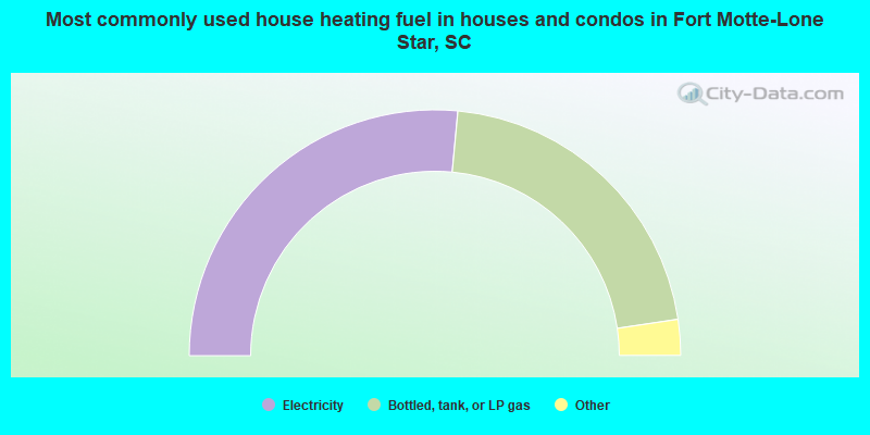
- 53.0%Electricity
- 42.3%Bottled, tank, or LP gas
- 2.2%Wood
- 1.9%Utility gas
- 0.5%Fuel oil, kerosene, etc.
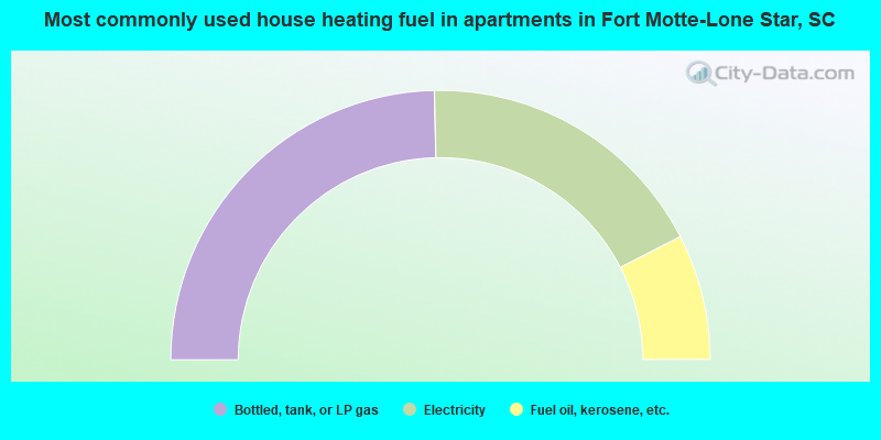
- 49.3%Bottled, tank, or LP gas
- 35.6%Electricity
- 15.1%Fuel oil, kerosene, etc.
Fort Motte-Lone Star compared to South Carolina state average:
- Unemployed percentage below state average.
- Black race population percentage above state average.
- Hispanic race population percentage significantly below state average.
- Median age above state average.
- Foreign-born population percentage significantly below state average.
- Length of stay since moving in significantly above state average.
- Number of rooms per house significantly below state average.
- House age significantly below state average.