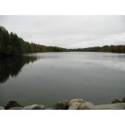
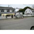
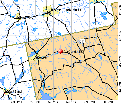
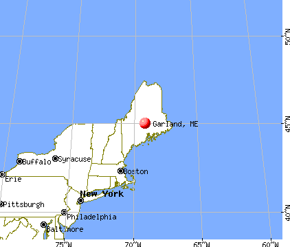
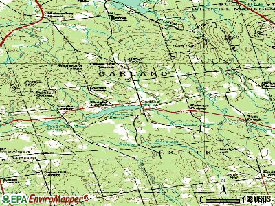
Garland, Maine
Submit your own pictures of this town and show them to the world
- OSM Map
- General Map
- Google Map
- MSN Map
Population change since 2000: +11.6%
 |
| Males: 573 | |
| Females: 532 |
| Median resident age: | 44.6 years |
| Maine median age: | 43.0 years |
Zip codes: 04939.
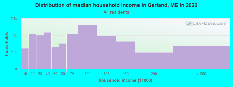
| Garland: | $49,051 |
| ME: | $69,543 |
Estimated per capita income in 2022: $25,378 (it was $12,624 in 2000)
Garland town income, earnings, and wages data
Estimated median house or condo value in 2022: $158,466 (it was $60,900 in 2000)
| Garland: | $158,466 |
| ME: | $290,600 |
Mean prices in 2022: all housing units: $235,563; detached houses: $252,705; townhouses or other attached units: $267,749; in 2-unit structures: $255,332; in 3-to-4-unit structures: $815,300; in 5-or-more-unit structures: $185,873; mobile homes: $93,017; occupied boats, rvs, vans, etc.: $21,333
Detailed information about poverty and poor residents in Garland, ME


Compare current foreclosures near Garland, ME:
| Photo | Address | Area | Beds / Baths | Price | Details |
|---|---|---|---|---|---|

|
#1
Grange St
Dover Foxcroft, ME 04426
|
- sq. feet
|
4 baths 4 beds |
show details | |

|
#2
Main St
Corinth, ME 04427
|
1,573 sq. feet
|
2 baths 3 beds |
show details | |

|
#3
Upper Cross Rd
Hudson, ME 04449
|
1,344 sq. feet
|
2 baths 3 beds |
show details | |

|
#4
Kenduskeag Levant Rd
Kenduskeag, ME 04450
|
- sq. feet
|
2 baths 3 beds |
show details | |

|
#5
Elm St
Newport, ME 04953
|
2,440 sq. feet
|
2 baths 4 beds |
show details | |

|
#6
Exeter Rd
Corinth, ME 04427
|
- sq. feet
|
- baths - beds |
show details | |

|
#7
Morison Ave
Corinth, ME 04427
|
- sq. feet
|
- baths - beds |
show details | |

|
#8
Wolfboro Rd
Stetson, ME 04488
|
- sq. feet
|
- baths - beds |
show details | |

|
#9
Range Rd
Dover Foxcroft, ME 04426
|
- sq. feet
|
- baths - beds |
show details | |

|
#10
Range Rd
Dover Foxcroft, ME 04426
|
- sq. feet
|
- baths - beds |
show details |
| Photo | Address | Area | Beds / Baths | Price | Details |
|---|---|---|---|---|---|

|
#11
Milo Rd
Sebec, ME 04481
|
- sq. feet
|
- baths - beds |
show details | |

|
#12
Broadway
Kenduskeag, ME 04450
|
- sq. feet
|
- baths - beds |
show details | |

|
#13
Lewis Trailer Park Rd
Milo, ME 04463
|
- sq. feet
|
- baths - beds |
show details | |

|
#14
Hudson Hill Rd
Hudson, ME 04449
|
- sq. feet
|
- baths - beds |
show details | |

|
#15
Hudson Rd
Hudson, ME 04449
|
- sq. feet
|
- baths - beds |
show details | |

|
Check over 1 million property listings on Foreclosure.com!
|
browse all offers | |||

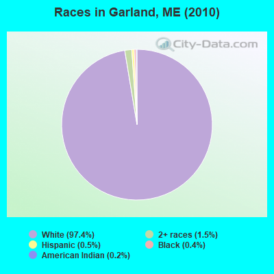
- 1,07697.4%White alone
- 171.5%Two or more races
- 60.5%Hispanic
- 40.4%Black alone
- 20.2%American Indian alone
Races in Garland detailed stats: ancestries, foreign born residents, place of birth
According to our research of Maine and other state lists, there were 5 registered sex offenders living in Garland, Maine as of April 27, 2024.
The ratio of all residents to sex offenders in Garland is 221 to 1.
 Recent articles from our blog. Our writers, many of them Ph.D. graduates or candidates, create easy-to-read articles on a wide variety of topics.

 | Opinions on making a move to Maine or New Hampshire (12 replies) |
| Maine weather thread (3207 replies) |
| Maine Governor: Drug Dealers Often 'Impregnate a Young White Gir'l (110 replies) |
| Where would you live in Bangor? (7 replies) |
| Need recs for land surveyor in Garland area (3 replies) |
| Camps, "temporary" structures and permits? (84 replies) |
Latest news from Garland, ME collected exclusively by city-data.com from local newspapers, TV, and radio stations
Ancestries: English (16.5%), United States (12.9%), French (10.4%), Irish (9.5%), French Canadian (4.1%), Scottish (3.3%).
Current Local Time: EST time zone
Incorporated on 02/16/1811
Elevation: 363 feet
Land area: 37.8 square miles.
Population density: 29 people per square mile (very low).
15 residents are foreign born
| This town: | 1.5% |
| Maine: | 2.9% |
| Garland town: | 1.2% ($712) |
| Maine: | 1.5% ($1,417) |
Nearest city with pop. 50,000+: Portland, ME  (110.3 miles , pop. 64,249).
Nearest city with pop. 200,000+: Boston, MA (211.9 miles , pop. 589,141).
Nearest city with pop. 1,000,000+: Bronx, NY (375.9 miles , pop. 1,332,650).
Nearest cities:
), ), ), Latitude: 45.05 N, Longitude: 69.16 W
Area code commonly used in this area: 207

| Here: | 7.1% |
| Maine: | 3.4% |
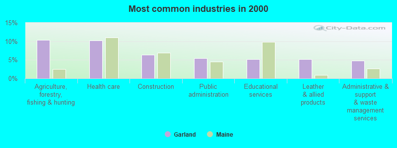
- Agriculture, forestry, fishing & hunting (10.4%)
- Health care (10.2%)
- Construction (6.3%)
- Public administration (5.4%)
- Educational services (5.2%)
- Leather & allied products (5.2%)
- Administrative & support & waste management services (4.8%)
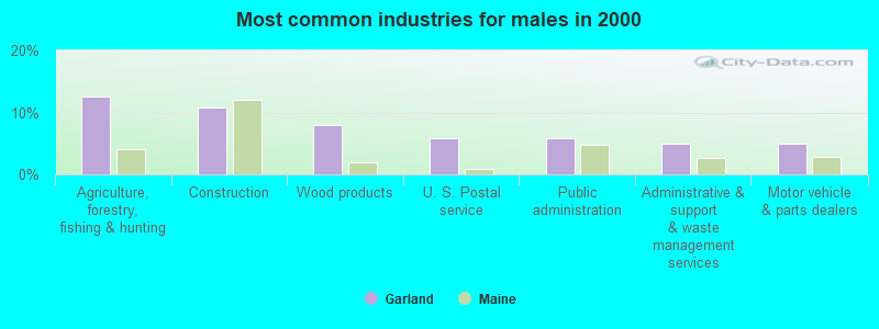
- Agriculture, forestry, fishing & hunting (12.5%)
- Construction (10.8%)
- Wood products (7.9%)
- U. S. Postal service (5.8%)
- Public administration (5.8%)
- Administrative & support & waste management services (5.0%)
- Motor vehicle & parts dealers (5.0%)
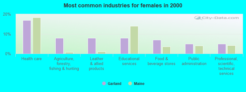
- Health care (16.8%)
- Agriculture, forestry, fishing & hunting (7.9%)
- Leather & allied products (7.9%)
- Educational services (7.9%)
- Food & beverage stores (6.9%)
- Public administration (5.0%)
- Professional, scientific, technical services (5.0%)
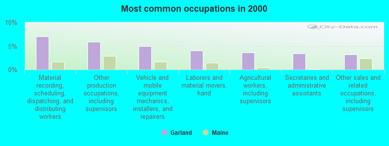
- Material recording, scheduling, dispatching, and distributing workers (7.0%)
- Other production occupations, including supervisors (5.9%)
- Vehicle and mobile equipment mechanics, installers, and repairers (5.0%)
- Laborers and material movers, hand (4.1%)
- Agricultural workers, including supervisors (3.6%)
- Secretaries and administrative assistants (3.4%)
- Other sales and related occupations, including supervisors (3.2%)
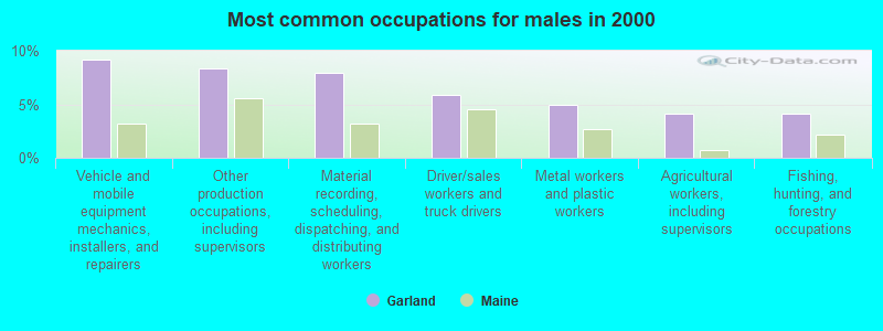
- Vehicle and mobile equipment mechanics, installers, and repairers (9.2%)
- Other production occupations, including supervisors (8.3%)
- Material recording, scheduling, dispatching, and distributing workers (7.9%)
- Driver/sales workers and truck drivers (5.8%)
- Metal workers and plastic workers (5.0%)
- Agricultural workers, including supervisors (4.2%)
- Fishing, hunting, and forestry occupations (4.2%)
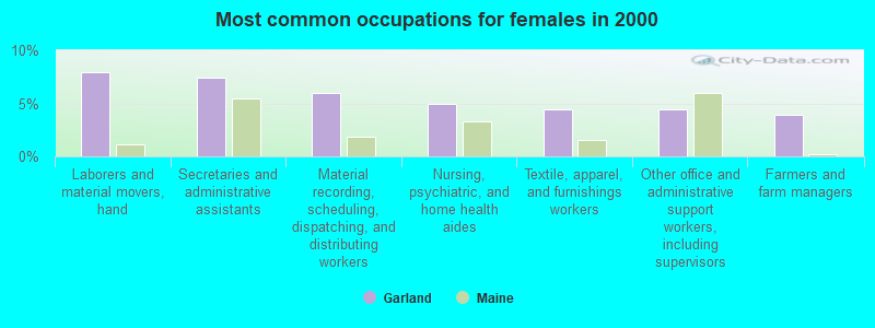
- Laborers and material movers, hand (7.9%)
- Secretaries and administrative assistants (7.4%)
- Material recording, scheduling, dispatching, and distributing workers (5.9%)
- Nursing, psychiatric, and home health aides (5.0%)
- Textile, apparel, and furnishings workers (4.5%)
- Other office and administrative support workers, including supervisors (4.5%)
- Farmers and farm managers (4.0%)
Average climate in Garland, Maine
Based on data reported by over 4,000 weather stations


(lower is better)
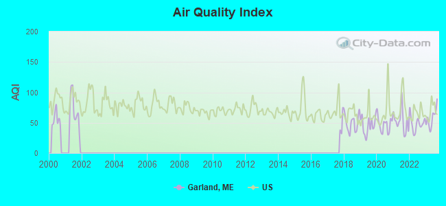
Air Quality Index (AQI) level in 2023 was 57.5. This is better than average.
| City: | 57.5 |
| U.S.: | 72.6 |
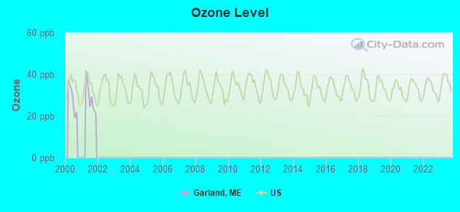
Ozone [ppb] level in 2001 was 28.8. This is about average. Closest monitor was 8.4 miles away from the city center.
| City: | 28.8 |
| U.S.: | 33.3 |
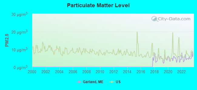
Particulate Matter (PM2.5) [µg/m3] level in 2023 was 5.62. This is significantly better than average. Closest monitor was 24.8 miles away from the city center.
| City: | 5.62 |
| U.S.: | 8.11 |
Earthquake activity:
Garland-area historical earthquake activity is significantly above Maine state average. It is 81% smaller than the overall U.S. average.On 4/20/2002 at 10:50:47, a magnitude 5.3 (5.3 ML, Depth: 3.0 mi, Class: Moderate, Intensity: VI - VII) earthquake occurred 225.8 miles away from Garland center
On 10/16/2012 at 23:12:25, a magnitude 4.7 (4.7 ML, Depth: 10.0 mi, Class: Light, Intensity: IV - V) earthquake occurred 124.7 miles away from Garland center
On 4/20/2002 at 10:50:47, a magnitude 5.2 (5.2 MB, 4.2 MS, 5.2 MW, 5.0 MW) earthquake occurred 227.1 miles away from Garland center
On 10/7/1983 at 10:18:46, a magnitude 5.3 (5.1 MB, 5.3 LG, 5.1 ML) earthquake occurred 266.6 miles away from the city center
On 1/19/1982 at 00:14:42, a magnitude 4.7 (4.5 MB, 4.7 MD, 4.5 LG) earthquake occurred 161.5 miles away from Garland center
On 2/26/1999 at 03:38:43, a magnitude 3.8 (3.8 LG, Depth: 2.0 mi, Class: Light, Intensity: II - III) earthquake occurred 43.1 miles away from Garland center
Magnitude types: regional Lg-wave magnitude (LG), body-wave magnitude (MB), duration magnitude (MD), local magnitude (ML), surface-wave magnitude (MS), moment magnitude (MW)
Natural disasters:
The number of natural disasters in Penobscot County (19) is greater than the US average (15).Major Disasters (Presidential) Declared: 11
Emergencies Declared: 7
Causes of natural disasters: Floods: 9, Storms: 8, Snows: 5, Heavy Rains: 2, Blizzard: 1, Hurricane: 1, Ice Storm: 1, Snowfall: 1, Wind: 1, Winter Storm: 1, Other: 2 (Note: some incidents may be assigned to more than one category).
Hospitals and medical centers near Garland:
- DEXTER HEALTH CARE (Nursing Home, about 7 miles away; DEXTER, ME)
- MAYO REGIONAL HOSPITAL Critical Access Hospitals (about 11 miles away; DOVER FOXCROFT, ME)
- HIBBARD NURSING HOME (Nursing Home, about 11 miles away; DOVER FOXCROFT, ME)
- SQUARE ROAD GROUP HOME (Hospital, about 13 miles away; SAINT ALBANS, ME)
Colleges/universities with over 2000 students nearest to Garland:
- Husson University (about 24 miles; Bangor, ME; Full-time enrollment: 2,421)
- University of Maine (about 27 miles; Orono, ME; FT enrollment: 8,931)
- University of Maine at Farmington (about 56 miles; Farmington, ME; FT enrollment: 2,036)
- University of Maine at Augusta (about 59 miles; Augusta, ME; FT enrollment: 3,204)
- Saint Joseph's College of Maine (about 107 miles; Standish, ME; FT enrollment: 2,010)
- Southern Maine Community College (about 111 miles; South Portland, ME; FT enrollment: 4,666)
- University of Southern Maine (about 111 miles; Portland, ME; FT enrollment: 6,647)
Points of interest:
Notable location: Garland Volunteer Fire Department (A). Display/hide its location on the map
Cemetery: Burnham Cemetery (1). Display/hide its location on the map
Lakes and reservoirs: West Garland Pond (A), Garland Pond (B). Display/hide their locations on the map
Streams, rivers, and creeks: Burnham Brook (A). Display/hide its location on the map
Park in Garland: Bud Leavitt Wildlife Management Area (1). Display/hide its location on the map
Drinking water stations with addresses in Garland and their reported violations in the past:
COUNTRYSIDE RESTAURANT (Population served: 250, Groundwater):Past monitoring violations:
- 2 routine major monitoring violations
- One regular monitoring violation
| This town: | 2.5 people |
| Maine: | 2.3 people |
| This town: | 72.2% |
| Whole state: | 62.9% |
| This town: | 8.4% |
| Whole state: | 9.4% |
Likely homosexual households (counted as self-reported same-sex unmarried-partner households)
- Lesbian couples: 0.0% of all households
- Gay men: 0.2% of all households
| This town: | 20.0% |
| Whole state: | 10.9% |
| This town: | 6.2% |
| Whole state: | 4.1% |
For population 15 years and over in Garland:
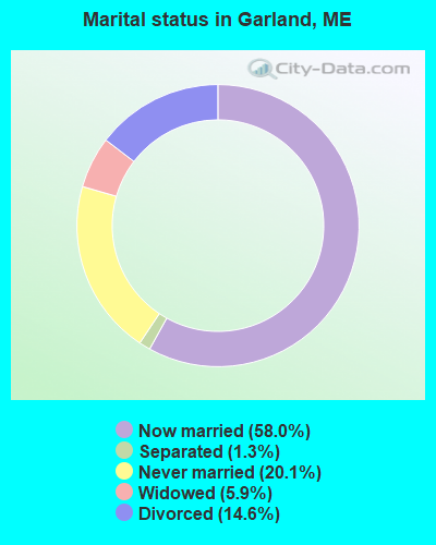
- Never married: 20.1%
- Now married: 58.0%
- Separated: 1.3%
- Widowed: 5.9%
- Divorced: 14.6%
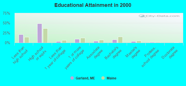
For population 25 years and over in Garland:
- High school or higher: 78.9%
- Bachelor's degree or higher: 12.7%
- Graduate or professional degree: 4.7%
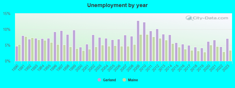
- Unemployed: 4.9%
- Mean travel time to work (commute): 27.6 minutes
| Here: | 10.0 |
| Maine average: | 11.2 |


Graphs represent county-level data. Detailed 2008 Election Results
Religion statistics for Garland, ME (based on Penobscot County data)


| Religion | Adherents | Congregations |
|---|---|---|
| Catholic | 16,581 | 15 |
| Mainline Protestant | 9,715 | 59 |
| Evangelical Protestant | 7,523 | 80 |
| Other | 2,936 | 22 |
| Orthodox | 300 | 1 |
| None | 116,868 | - |
Food Environment Statistics:
| Penobscot County: | 2.29 / 10,000 pop. |
| Maine: | 2.80 / 10,000 pop. |
| This county: | 0.13 / 10,000 pop. |
| Maine: | 0.14 / 10,000 pop. |
| Penobscot County: | 2.56 / 10,000 pop. |
| Maine: | 2.20 / 10,000 pop. |
| Here: | 5.72 / 10,000 pop. |
| Maine: | 5.75 / 10,000 pop. |
| Penobscot County: | 7.41 / 10,000 pop. |
| State: | 11.02 / 10,000 pop. |
| This county: | 9.0% |
| Maine: | 8.2% |
| Penobscot County: | 28.0% |
| Maine: | 25.0% |
Strongest AM radio stations in Garland:
- WZON (620 AM; 5 kW; BANGOR, ME; Owner: THE ZONE CORPORATION)
- WSKW (1160 AM; 10 kW; SKOWHEGAN, ME; Owner: MOUNTAIN WIRELESS, INCORPORATED)
- WABI (910 AM; 5 kW; BANGOR, ME; Owner: CLEAR CHANNEL BROADCASTING LICENSES, INC.)
- WTME (780 AM; 10 kW; RUMFORD, ME; Owner: MOUNTAIN VALLEY BROADCASTING, INC.)
- WRKO (680 AM; 50 kW; BOSTON, MA; Owner: ENTERCOM BOSTON LICENSE, LLC)
- WDEA (1370 AM; 5 kW; ELLSWORTH, ME; Owner: CUMULUS LICENSING CORP.)
- WEEI (850 AM; 50 kW; BOSTON, MA; Owner: ENTERCOM BOSTON LICENSE, LLC)
- WBZ (1030 AM; 50 kW; BOSTON, MA; Owner: INFINITY BROADCASTING OPERATIONS, INC.)
- WCRN (830 AM; 50 kW; WORCESTER, MA; Owner: CARTER BROADCASTING CORPORATION)
- WNNZ (640 AM; 50 kW; WESTFIELD, MA; Owner: CLEAR CHANNEL BROADCASTING LICENSES, INC.)
- WNZS (1340 AM; 1 kW; VEAZIE, ME; Owner: WATERFRONT COMMUNICATIONS INC.)
- WCHP (760 AM; 35 kW; CHAMPLAIN, NY; Owner: CHAMPLAIN RADIO, INC.)
- WFAU (1280 AM; 5 kW; GARDINER, ME; Owner: CAPSTAR TX LIMITED PARTNERSHIP)
Strongest FM radio stations in Garland:
- WQCB (106.5 FM; BREWER, ME; Owner: CUMULUS LICENSING CORP.)
- WGUY (102.1 FM; DEXTER, ME; Owner: CONCORD MEDIA GROUP, INC.)
- WWBX (97.1 FM; BANGOR, ME; Owner: CLEAR CHANNEL BROADCASTING LICENSES, INC.)
- WVOM (103.9 FM; HOWLAND, ME; Owner: CLEAR CHANNEL BROADCASTING LICENSES, INC.)
- WDME-FM (103.1 FM; DOVER-FOXCROFT, ME; Owner: THE ZONE CORPORATION)
- WHCF (88.5 FM; BANGOR, ME; Owner: BANGOR BAPTIST CHURCH)
- WTOS-FM (105.1 FM; SKOWHEGAN, ME; Owner: CAPSTAR TX LIMITED PARTNERSHIP)
- WBZN (107.3 FM; OLD TOWN, ME; Owner: CUMULUS LICENSING CORP.)
- WBFB (104.7 FM; BELFAST, ME; Owner: CLEAR CHANNEL BROADCASTING LICENSES, INC.)
- WKIT-FM (100.3 FM; BREWER, ME; Owner: THE ZONE CORPORATION)
- WJCX (99.5 FM; PITTSFIELD, ME; Owner: CSN INTERNATIONAL)
- WWMJ (95.7 FM; ELLSWORTH, ME; Owner: CUMULUS LICENSING CORP.)
- WMEH (90.9 FM; BANGOR, ME; Owner: MAINE PUBLIC BROADCASTING CORPORATION)
- WEZQ (92.9 FM; BANGOR, ME; Owner: CUMULUS LICENSING CORP.)
- WHQO (107.9 FM; SKOWHEGAN, ME; Owner: MOUNTAIN WIRELESS, INC.)
TV broadcast stations around Garland:
- WABI-TV (Channel 5; BANGOR, ME; Owner: COMMUNITY BROADCASTING SERVICE)
- W36CK (Channel 36; BANGOR, ME; Owner: TRINITY BROADCASTING NETWORK)
- W27CE (Channel 19; DOVER-FOXCROFT, ME; Owner: TRINITY BROADCASTING NETWORK)
Garland fatal accident list:
Aug 30, 2018 11:01 AM, Sr-Corinth Road, Lat: 45.033169, Lon: -69.135411, Vehicles: 1, Persons: 1, Fatalities: 1
Aug 7, 2004 00:14 AM, Campbell Road, Vehicles: 1, Persons: 1, Fatalities: 1, Drunk persons involved: 1
Aug 11, 2004 07:55 PM, Oliver Hill Road, Vehicles: 1, Persons: 1, Fatalities: 1
Nov 5, 1997 03:55 PM, 94, Vehicles: 1, Persons: 3, Fatalities: 1
Sep 4, 1987 03:55 PM, 16601674, Vehicles: 1, Persons: 1, Fatalities: 1, Drunk persons involved: 1
- National Bridge Inventory (NBI) Statistics
- 3Number of bridges
- 13ft / 4.2mTotal length
- 104,359Total average daily traffic
- 5,217Total average daily truck traffic
- 4,881Total future (year 2036) average daily traffic
FCC Registered Antenna Towers:
17 (See the full list of FCC Registered Antenna Towers in Garland)FCC Registered Commercial Land Mobile Towers:
1 (See the full list of FCC Registered Commercial Land Mobile Towers in Garland, ME)FCC Registered Private Land Mobile Towers:
1 (See the full list of FCC Registered Private Land Mobile Towers)FCC Registered Broadcast Land Mobile Towers:
8 (See the full list of FCC Registered Broadcast Land Mobile Towers)FCC Registered Microwave Towers:
3- STATION, Mansfield Ledge (Lat: 45.057278 Lon: -69.190306), Overall height: 217.9 m, Call Sign: WNTT578,
Assigned Frequencies: 955.600 MHz, Grant Date: 09/12/2018, Expiration Date: 11/24/2028, Registrant: State Of Maine, O.I.T., Radio Operations, 66 Industrial Drive, Augusta, ME 04333-0147, Phone: (207) 624-9990, Email:
- GARLAND, Oliver Hill Road (Lat: 45.067250 Lon: -69.166250), Type: Mast, Structure height: 36.6 m, Call Sign: WQOZ232,
Assigned Frequencies: 956.900 MHz, 6635.00 MHz, 6635.00 MHz, 6635.00 MHz, 6635.00 MHz, 6635.00 MHz, 6635.00 MHz, 6635.00 MHz, 6635.00 MHz, Grant Date: 12/21/2021, Expiration Date: 03/09/2032, Certifier: David J Plourde, Registrant: State Of Maine, O.I.T., Radio Operations Mscn, 66 Industrial Drive, Augusta, ME 04333-0147, Phone: (207) 624-9990, Email:
- Shaw Rd, 238 Foss Hill Rd / Us-Me-5005 (Lat: 45.056750 Lon: -69.190750), Type: Gtower, Structure height: 217 m, Overall height: 218.5 m, Call Sign: WQVA977,
Assigned Frequencies: 11385.0 MHz, 11385.0 MHz, 11385.0 MHz, 11385.0 MHz, 11385.0 MHz, 11385.0 MHz, 11385.0 MHz, 11385.0 MHz, 11385.0 MHz, Grant Date: 12/11/2014, Expiration Date: 12/11/2024, Cancellation Date: 07/24/2020, Certifier: Jessica B Lyons, Registrant: At&t Mobility LLC, 208 S. Akard Street, Room 2100, Dallas, TX 75202, Phone: (855) 699-7073, Email:
FCC Registered Paging Towers:
1- Approx 2 Mi. Nw Ofgarland, Memphis (Lat: 45.057278 Lon: -69.190306), Type: Tower, Structure height: 217 m, Overall height: 217.9 m, Call Sign: KNKC725,
Assigned Frequencies: 152.780 MHz, Grant Date: 05/11/1999, Expiration Date: 04/01/2009, Cancellation Date: 01/30/2009, Certifier: Shawn E Endsley, Registrant: Usa Mobility Wireless, Inc., 300 Technology Drive #400, Plano, TX 75074, Phone: (972) 801-1626, Fax: (972) 801-1699, Email:
FCC Registered Amateur Radio Licenses:
22 (See the full list of FCC Registered Amateur Radio Licenses in Garland)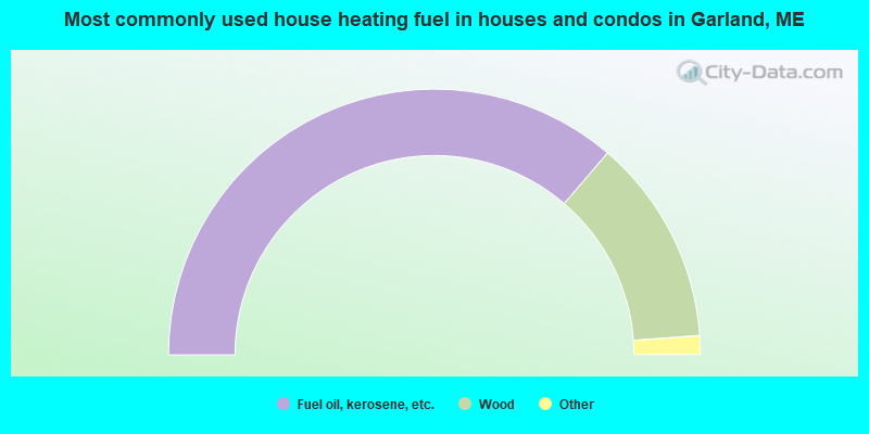
- 72.5%Fuel oil, kerosene, etc.
- 25.1%Wood
- 1.7%Bottled, tank, or LP gas
- 0.6%Coal or coke
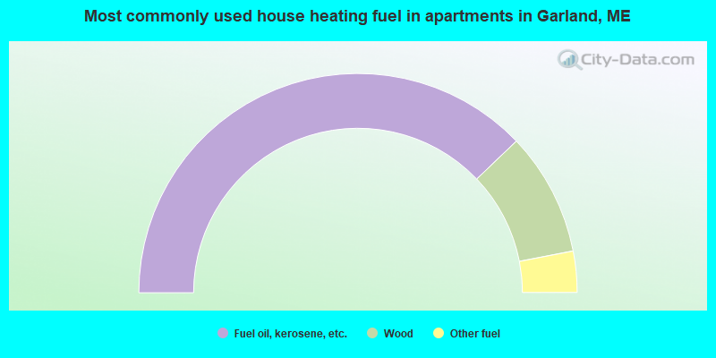
- 75.8%Fuel oil, kerosene, etc.
- 18.2%Wood
- 6.1%Other fuel
Garland compared to Maine state average:
- Median house value below state average.
- Unemployed percentage below state average.
- Black race population percentage significantly below state average.
- Hispanic race population percentage significantly below state average.
- Foreign-born population percentage significantly below state average.
- Renting percentage significantly below state average.
- Length of stay since moving in significantly above state average.
- Number of rooms per house significantly below state average.
- House age significantly below state average.
- Number of college students below state average.
- Percentage of population with a bachelor's degree or higher below state average.

|
Total of 1 patent application in 2008-2024.