Habersham, Tennessee
Submit your own pictures of this place and show them to the world
- OSM Map
- General Map
- Google Map
- MSN Map

| Males: 1,829 | |
| Females: 1,840 |
| Median resident age: | 35.9 years |
| Tennessee median age: | 35.9 years |
Zip code: 37766
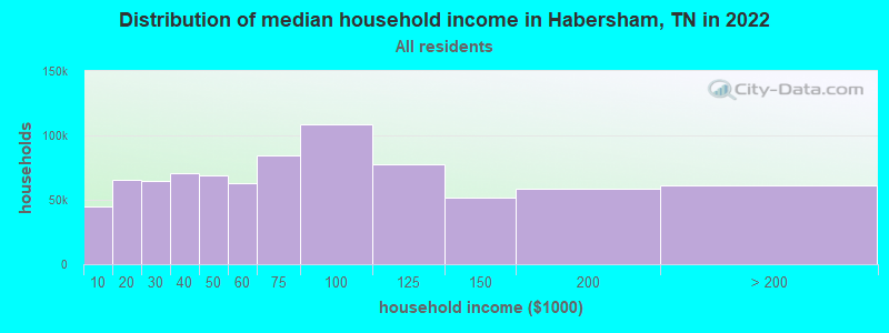
| Habersham: | $40,788 |
| TN: | $65,254 |
Estimated per capita income in 2022: $21,145 (it was $10,308 in 2000)
Habersham CCD income, earnings, and wages data
Estimated median house or condo value in 2022: $90,355 (it was $29,900 in 2000)
| Habersham: | $90,355 |
| TN: | $284,800 |
Detailed information about poverty and poor residents in Habersham, TN
Compare current foreclosures near Habersham, TN:
| Photo | Address | Area | Beds / Baths | Price | Details |
|---|---|---|---|---|---|

|
#1
S Sudenny Ln
La Follette, TN 37766
|
504 sq. feet
|
2 baths - beds |
show details | |

|
#2
Rose Hill Dr
La Follette, TN 37766
|
- sq. feet
|
1 baths 3 beds |
show details | |

|
#3
Buena Vista Ln
La Follette, TN 37766
|
1,160 sq. feet
|
1 baths - beds |
show details | |

|
#4
Terry Ln
Caryville, TN 37714
|
1,404 sq. feet
|
1 baths - beds |
show details | |

|
#5
Cherry St # A
La Follette, TN 37766
|
1,288 sq. feet
|
1 baths - beds |
show details | |

|
#6
S High Knob Rd
La Follette, TN 37766
|
1,008 sq. feet
|
1 baths - beds |
show details | |

|
#7
W Chestnut St
La Follette, TN 37766
|
972 sq. feet
|
1 baths - beds |
show details | |

|
#8
Hatmaker Dr
La Follette, TN 37766
|
1,208 sq. feet
|
2 baths - beds |
show details | |

|
#9
Mcneeley Dr
La Follette, TN 37766
|
1,242 sq. feet
|
2 baths - beds |
show details | |

|
#10
College Park Rd
La Follette, TN 37766
|
1,456 sq. feet
|
2 baths - beds |
show details |
| Photo | Address | Area | Beds / Baths | Price | Details |
|---|---|---|---|---|---|

|
#11
Jane Way Ln
Jacksboro, TN 37757
|
1,660 sq. feet
|
1 baths - beds |
show details | |

|
#12
Demory Rd
La Follette, TN 37766
|
768 sq. feet
|
1 baths - beds |
show details | |

|
#13
Hatmaker Ln
La Follette, TN 37766
|
658 sq. feet
|
1 baths - beds |
show details | |

|
#14
Vinsant Estates Rd
Jacksboro, TN 37757
|
1,920 sq. feet
|
2 baths - beds |
show details | |

|
#15
Gail Ln
Jacksboro, TN 37757
|
1,008 sq. feet
|
1 baths - beds |
show details | |

|
#16
Asbury Rd
Jacksboro, TN 37757
|
1,020 sq. feet
|
1 baths - beds |
show details | |

|
#17
Grantsboro Rd
La Follette, TN 37766
|
1,330 sq. feet
|
1 baths - beds |
show details | |

|
#18
Bruce Gap Rd
Caryville, TN 37714
|
1,248 sq. feet
|
1 baths - beds |
show details | |

|
#19
Bluff Trce
Jacksboro, TN 37757
|
3,982 sq. feet
|
3 baths - beds |
show details | |

|
#20
Dower Ln
Caryville, TN 37714
|
1,344 sq. feet
|
2 baths - beds |
show details |
| Photo | Address | Area | Beds / Baths | Price | Details |
|---|---|---|---|---|---|

|
#21
N Shorewood Ln
Caryville, TN 37714
|
2,009 sq. feet
|
3 baths - beds |
show details | |

|
#22
Murrayville Rd
La Follette, TN 37766
|
1,450 sq. feet
|
2 baths - beds |
show details | |

|
#23
Hembree Ln
Caryville, TN 37714
|
1,080 sq. feet
|
- baths - beds |
show details | |

|
#24
Emerald Glen Dr
Caryville, TN 37714
|
1,508 sq. feet
|
2 baths - beds |
show details | |

|
#25
Oak Grove Rd
Lake City, TN 37769
|
1,200 sq. feet
|
1 baths - beds |
show details | |

|
#26
Straight Fork Rd
Huntsville, TN 37756
|
1,036 sq. feet
|
2 baths - beds |
show details | |

|
#27
Toppy Russell Rd
Speedwell, TN 37870
|
1,404 sq. feet
|
1 baths - beds |
show details | |

|
#28
Brantley Acres Rd
Speedwell, TN 37870
|
1,836 sq. feet
|
2 baths - beds |
show details | |

|
#29
Kenzie Ln
La Follette, TN 37766
|
1,100 sq. feet
|
2 baths - beds |
show details | |

|
#30
Parrott St
Jacksboro, TN 37757
|
1,320 sq. feet
|
1 baths - beds |
show details |
| Photo | Address | Area | Beds / Baths | Price | Details |
|---|---|---|---|---|---|

|
#31
Stonewall Ln
La Follette, TN 37766
|
1,120 sq. feet
|
1 baths - beds |
show details | |

|
#32
Morton Rd
La Follette, TN 37766
|
1,118 sq. feet
|
1 baths - beds |
show details | |

|
#33
Alex Smith Ln
La Follette, TN 37766
|
1,792 sq. feet
|
1 baths - beds |
show details | |

|
#34
Magnolia Ln
La Follette, TN 37766
|
1,174 sq. feet
|
1 baths - beds |
show details | |

|
#35
Kimberly Rd
La Follette, TN 37766
|
960 sq. feet
|
1 baths - beds |
show details | |

|
#36
E Prospect St
La Follette, TN 37766
|
792 sq. feet
|
1 baths - beds |
show details | |

|
#37
Lone Rd
Pioneer, TN 37847
|
896 sq. feet
|
1 baths - beds |
show details | |

|
#38
Hickory Hill Cir
Duff, TN 37729
|
1,120 sq. feet
|
1 baths - beds |
show details | |

|
#39
Indian Mountain Rd
Jellico, TN 37762
|
552 sq. feet
|
1 baths - beds |
show details | |

|
#40
Imperial Heights Ln
La Follette, TN 37766
|
728 sq. feet
|
1 baths - beds |
show details |
| Photo | Address | Area | Beds / Baths | Price | Details |
|---|---|---|---|---|---|

|
#41
White Oak Rd
Duff, TN 37729
|
1,302 sq. feet
|
1 baths - beds |
show details | |

|
#42
Chapman Crest Dr
La Follette, TN 37766
|
1,379 sq. feet
|
1 baths - beds |
show details | |

|
#43
Ivydale Rd
La Follette, TN 37766
|
1,260 sq. feet
|
1 baths - beds |
show details | |

|
#44
Sled Creek Rd
Duff, TN 37729
|
1,105 sq. feet
|
1 baths - beds |
show details | |

|
#45
Lick Creek Ln
La Follette, TN 37766
|
1,444 sq. feet
|
1 baths - beds |
show details | |

|
#46
S Cumberland Ave
La Follette, TN 37766
|
754 sq. feet
|
1 baths - beds |
show details | |

|
#47
Pruden Rd
Clairfield, TN 37715
|
- sq. feet
|
- baths - beds |
show details | |

|
#48
Lucy Ann Ln
Jacksboro, TN 37757
|
- sq. feet
|
- baths - beds |
show details | |

|
#49
Mount Paran Rd
Jacksboro, TN 37757
|
- sq. feet
|
- baths - beds |
show details | |

|
Check over 1 million property listings on Foreclosure.com!
|
browse all offers | |||

- 3,52397.7%White alone
- 451.2%Two or more races
- 240.7%Hispanic
- 120.3%American Indian alone
- 20.06%Asian alone
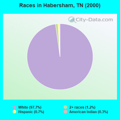
Races in Habersham detailed stats: ancestries, foreign born residents, place of birth
 Recent articles from our blog. Our writers, many of them Ph.D. graduates or candidates, create easy-to-read articles on a wide variety of topics.
Current Local Time: EST time zone
Elevation: 1260 feet
Land area: 170.1 square miles.
Population density: 22 people per square mile (very low).
| Habersham CCD: | 0.7% ($199) |
| Tennessee: | 0.8% ($715) |
Nearest city with pop. 50,000+: Knoxville, TN  (36.7 miles , pop. 173,890).
Nearest city with pop. 200,000+: Fayette, KY (108.8 miles , pop. 260,512).
Nearest city with pop. 1,000,000+: Chicago, IL (416.7 miles , pop. 2,896,016).
Nearest cities:
), ), ), Latitude: 36.49 N, Longitude: 84.11 W
Area code commonly used in this area: 423

| Here: | 3.6% |
| Tennessee: | 3.0% |
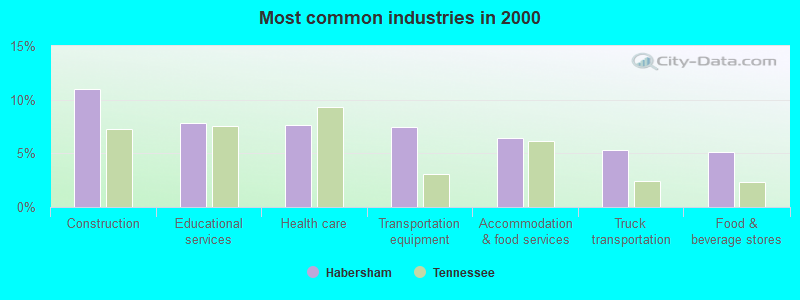
- Construction (11.0%)
- Educational services (7.8%)
- Health care (7.6%)
- Transportation equipment (7.4%)
- Accommodation & food services (6.5%)
- Truck transportation (5.3%)
- Food & beverage stores (5.1%)
- Construction (20.6%)
- Transportation equipment (10.9%)
- Truck transportation (7.5%)
- Mining, quarrying, oil & gas extraction (7.4%)
- Metal & metal products (7.4%)
- Food & beverage stores (4.7%)
- Beverage & tobacco products (3.2%)
- Health care (16.4%)
- Educational services (14.7%)
- Accommodation & food services (13.9%)
- Finance & insurance (7.7%)
- Department & other general merchandise stores (5.6%)
- Food & beverage stores (5.6%)
- Apparel (4.8%)
- Other production occupations, including supervisors (8.7%)
- Driver/sales workers and truck drivers (7.9%)
- Material recording, scheduling, dispatching, and distributing workers (5.6%)
- Metal workers and plastic workers (5.6%)
- Other sales and related occupations, including supervisors (4.5%)
- Laborers and material movers, hand (3.9%)
- Nursing, psychiatric, and home health aides (3.7%)
- Driver/sales workers and truck drivers (13.7%)
- Other production occupations, including supervisors (12.0%)
- Metal workers and plastic workers (7.4%)
- Laborers and material movers, hand (7.2%)
- Construction traders workers except carpenters, electricians, painters, plumbers, and construction laborers (6.5%)
- Vehicle and mobile equipment mechanics, installers, and repairers (5.9%)
- Material recording, scheduling, dispatching, and distributing workers (5.5%)
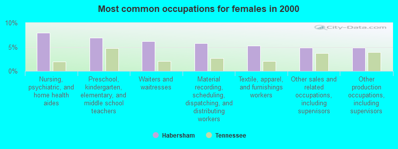
- Nursing, psychiatric, and home health aides (7.9%)
- Preschool, kindergarten, elementary, and middle school teachers (6.9%)
- Waiters and waitresses (6.2%)
- Material recording, scheduling, dispatching, and distributing workers (5.8%)
- Textile, apparel, and furnishings workers (5.2%)
- Other sales and related occupations, including supervisors (4.8%)
- Other production occupations, including supervisors (4.8%)
Average climate in Habersham, Tennessee
Based on data reported by over 4,000 weather stations


(lower is better)
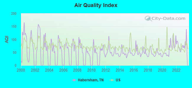
Air Quality Index (AQI) level in 2023 was 80.8. This is about average.
| City: | 80.8 |
| U.S.: | 72.6 |
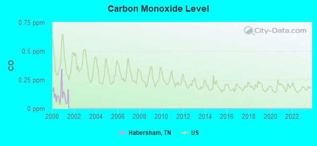
Carbon Monoxide (CO) [ppm] level in 2000 was 0.127. This is significantly better than average. Closest monitor was 22.6 miles away from the city center.
| City: | 0.127 |
| U.S.: | 0.251 |
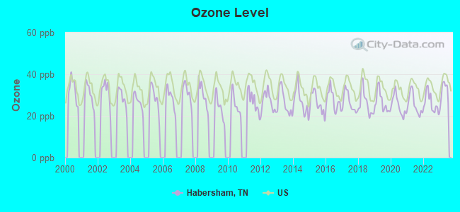
Ozone [ppb] level in 2023 was 31.5. This is about average. Closest monitor was 15.9 miles away from the city center.
| City: | 31.5 |
| U.S.: | 33.3 |
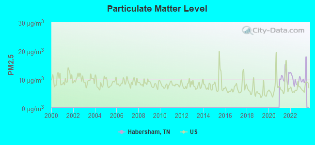
Particulate Matter (PM2.5) [µg/m3] level in 2022 was 9.68. This is about average. Closest monitor was 22.6 miles away from the city center.
| City: | 9.68 |
| U.S.: | 8.11 |
Tornado activity:
Habersham-area historical tornado activity is below Tennessee state average. It is 23% smaller than the overall U.S. average.
On 4/3/1974, a category F4 (max. wind speeds 207-260 mph) tornado 29.5 miles away from the Habersham place center .
On 3/12/1967, a category F3 (max. wind speeds 158-206 mph) tornado 12.8 miles away from the place center .
Earthquake activity:
Habersham-area historical earthquake activity is significantly above Tennessee state average. It is 81% greater than the overall U.S. average.On 7/27/1980 at 18:52:21, a magnitude 5.2 (5.1 MB, 4.7 MS, 5.0 UK, 5.2 UK, Class: Moderate, Intensity: VI - VII) earthquake occurred 119.3 miles away from Habersham center
On 11/30/1973 at 07:48:41, a magnitude 4.7 (4.7 MB, 4.6 ML, Class: Light, Intensity: IV - V) earthquake occurred 48.2 miles away from the city center
On 8/9/2020 at 12:07:37, a magnitude 5.1 (5.1 MW, Depth: 4.7 mi) earthquake occurred 167.9 miles away from the city center
On 4/18/2008 at 09:36:59, a magnitude 5.4 (5.1 MB, 4.8 MS, 5.4 MW, 5.2 MW) earthquake occurred 247.7 miles away from the city center
On 4/29/2003 at 08:59:39, a magnitude 4.9 (4.4 MB, 4.6 MW, 4.9 LG) earthquake occurred 162.1 miles away from the city center
On 12/12/2018 at 09:14:43, a magnitude 4.4 (4.4 MW, Depth: 4.9 mi) earthquake occurred 69.6 miles away from Habersham center
Magnitude types: regional Lg-wave magnitude (LG), body-wave magnitude (MB), local magnitude (ML), surface-wave magnitude (MS), moment magnitude (MW)
Natural disasters:
The number of natural disasters in Campbell County (19) is greater than the US average (15).Major Disasters (Presidential) Declared: 14
Emergencies Declared: 2
Causes of natural disasters: Floods: 14, Storms: 12, Tornadoes: 5, Winter Storms: 4, Winds: 3, Flash Flood: 1, Heavy Rain: 1, Hurricane: 1, Ice Storm: 1, Landslide: 1, Mudslide: 1, Snowfall: 1, Other: 1 (Note: some incidents may be assigned to more than one category).
Hospitals and medical centers near Habersham:
- SUNBELT HOMECARE (Home Health Center, about 7 miles away; JELLICO, TN)
- BEECH TREE MANOR (Nursing Home, about 7 miles away; JELLICO, TN)
- JELLICO COMMUNITY HOSPITAL Acute Care Hospitals (about 7 miles away; JELLICO, TN)
- TENNOVA HEALTHCARE-LAFOLLETT MEDICAL CENTER Acute Care Hospitals (about 7 miles away; LA FOLLETTE, TN)
- FMC LAFOLLETTE (Dialysis Facility, about 8 miles away; LAFOLLETTE, TN)
- MOUNTAIN VIEW NURSING HOME (Nursing Home, about 8 miles away; LAFOLLETTE, TN)
- CUMBERLAND VILLAGE CARE AND REHABILITATION CENTER (Nursing Home, about 10 miles away; LAFOLLETTE, TN)
Colleges/universities with over 2000 students nearest to Habersham:
- University of the Cumberlands (about 18 miles; Williamsburg, KY; Full-time enrollment: 3,585)
- Lincoln Memorial University (about 27 miles; Harrogate, TN; FT enrollment: 3,706)
- Pellissippi State Community College (about 38 miles; Knoxville, TN; FT enrollment: 7,271)
- The University of Tennessee-Knoxville (about 39 miles; Knoxville, TN; FT enrollment: 25,483)
- Somerset Community College (about 49 miles; Somerset, KY; FT enrollment: 4,698)
- Roane State Community College (about 51 miles; Harriman, TN; FT enrollment: 4,302)
- Walters State Community College (about 52 miles; Morristown, TN; FT enrollment: 4,359)
Points of interest:
Notable location: White Oak Volunteer Fire Department (A). Display/hide its location on the map
Churches in Habersham include: Anthras Baptist Church (A), Bairds Chapel (B), Primroy Church (C), Friendly Valley Church (D), Stanville Church (E), Walnut Grove Church (F), Woodson Gap Baptist Church (G), White Oak Missionary Baptist Church (H), White Oak Church of Christ (I). Display/hide their locations on the map
Cemeteries: Samp Meredith Cemetery (1), Johnson Cemetery (2), Walden Cemetery (3), Perkins Cemetery (4), Peabody Cemetery (5), Gibson Cemetery (6), Bowlin Cemetery (7). Display/hide their locations on the map
Reservoirs: La Follette Reservoir (A), Eblen-Powell Number Two Reservoir (B), Eblen-Powell Number One Reservoir (C). Display/hide their locations on the map
Streams, rivers, and creeks: Major Branch (A), Leonard Branch (B), Jim Branch (C), Jennings Creek (D), Houston Ayers Branch (E), Horse Creek (F), Hogcamp Branch (G), Hickory Creek (H), Hatmaker Branch (I). Display/hide their locations on the map
| This place: | 2.6 people |
| Tennessee: | 2.5 people |
| This place: | 63.4% |
| Whole state: | 69.8% |
| This place: | 3.8% |
| Whole state: | 4.2% |
Likely homosexual households (counted as self-reported same-sex unmarried-partner households)
- Lesbian couples: 0.1% of all households
- Gay men: 0.1% of all households
| This place: | 24.9% |
| Whole state: | 13.5% |
| This place: | 10.2% |
| Whole state: | 5.8% |
For population 15 years and over in Habersham:
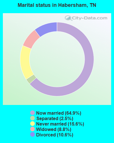
- Never married: 15.6%
- Now married: 64.9%
- Separated: 2.5%
- Widowed: 8.8%
- Divorced: 10.6%
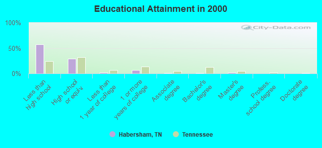
For population 25 years and over in Habersham:
- High school or higher: 42.3%
- Bachelor's degree or higher: 3.1%
- Graduate or professional degree: 1.8%
- Unemployed: 9.6%
- Mean travel time to work (commute): 34.3 minutes
| Here: | 18.9 |
| Tennessee average: | 13.3 |
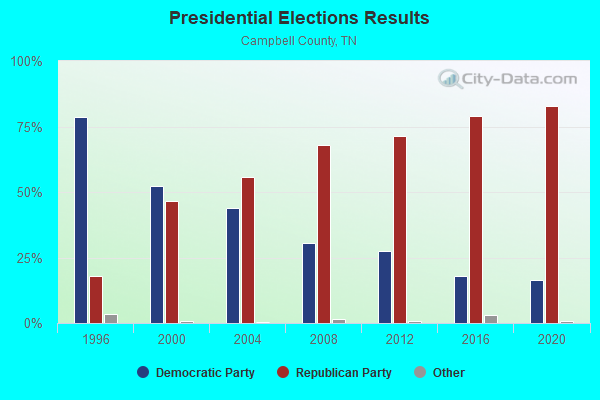
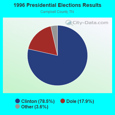
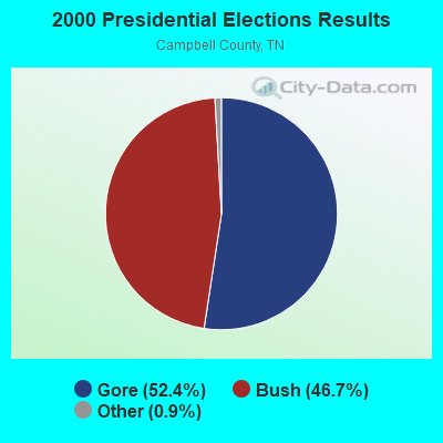
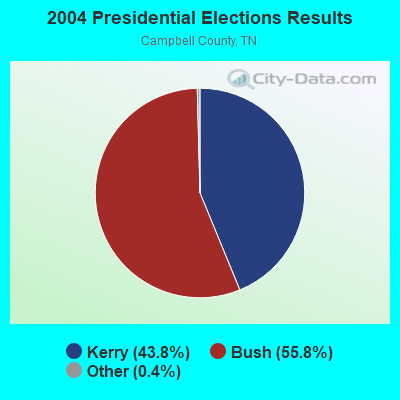
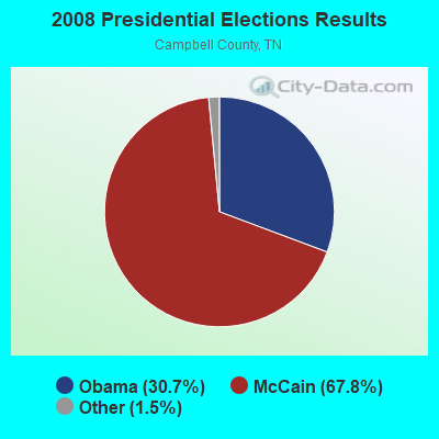

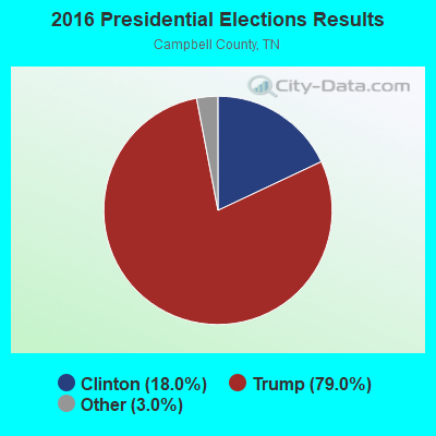
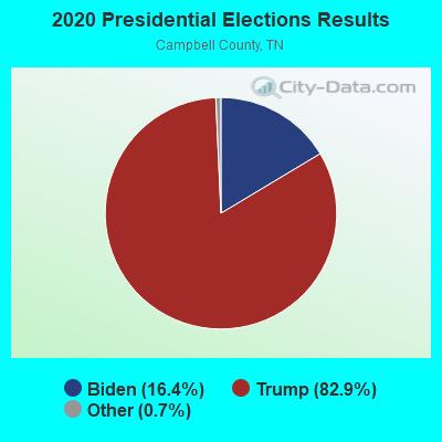
Graphs represent county-level data. Detailed 2008 Election Results
Religion statistics for Habersham, TN (based on Campbell County data)
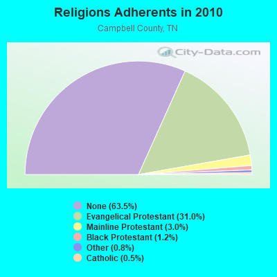
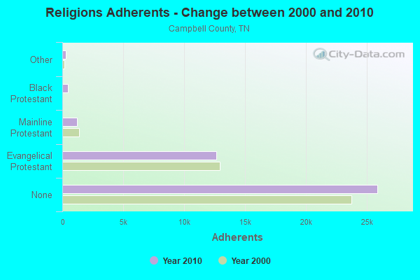
| Religion | Adherents | Congregations |
|---|---|---|
| Evangelical Protestant | 12,641 | 56 |
| Mainline Protestant | 1,231 | 9 |
| Black Protestant | 481 | 3 |
| Other | 311 | 3 |
| Catholic | 190 | 1 |
| None | 25,862 | - |
Food Environment Statistics:
| This county: | 2.46 / 10,000 pop. |
| Tennessee: | 1.99 / 10,000 pop. |
| Campbell County: | 0.25 / 10,000 pop. |
| Tennessee: | 0.17 / 10,000 pop. |
| Campbell County: | 0.25 / 10,000 pop. |
| Tennessee: | 0.65 / 10,000 pop. |
| This county: | 6.88 / 10,000 pop. |
| Tennessee: | 5.16 / 10,000 pop. |
| Campbell County: | 3.44 / 10,000 pop. |
| State: | 6.56 / 10,000 pop. |
| Campbell County: | 13.3% |
| Tennessee: | 11.4% |
| Campbell County: | 30.7% |
| Tennessee: | 30.2% |
| Here: | 15.7% |
| Tennessee: | 13.5% |
Strongest AM radio stations in Habersham:
- WKVL (850 AM; daytime; 50 kW; KNOXVILLE, TN; Owner: HORNE RADIO, LLC)
- WJJT (1540 AM; 1 kW; JELLICO, TN; Owner: DOUGLAS BROADCASTING CORPORATION)
- WEKC (710 AM; daytime; 4 kW; WILLIAMSBURG, KY; Owner: GERALD PARKS)
- WLAF (1450 AM; 1 kW; LA FOLLETTE, TN; Owner: CAMPBELL COUNTY B/CING. CORP.)
- WQBB (1040 AM; daytime; 10 kW; POWELL, TN; Owner: JOURNAL BROADCAST CORPORATION)
- WNOX (990 AM; 10 kW; KNOXVILLE, TN)
- WMIK (560 AM; 2 kW; MIDDLESBORO, KY; Owner: GATEWAY BROADCASTING, INC.)
- WEZJ (1440 AM; 2 kW; WILLIAMSBURG, KY; Owner: WHITLEY BROADCASTING CO., INC.)
- WVLZ (1180 AM; daytime; 10 kW; KNOXVILLE, TN; Owner: KIRKLAND WIRELESS BROADCASTERS, INC.)
- WRJZ (620 AM; 5 kW; KNOXVILLE, TN; Owner: TENNESSEE MEDIA ASSOCIATES, INC)
- WATO (1290 AM; 5 kW; OAK RIDGE, TN)
- WKDP (1330 AM; 5 kW; CORBIN, KY; Owner: EUBANKS BROADCASTING, INC.)
- WFGW (1010 AM; 50 kW; BLACK MOUNTAIN, NC; Owner: BLUE RIDGE BROADCASTING CORP.)
Strongest FM radio stations in Habersham:
- WDVX (89.9 FM; CLINTON, TN; Owner: CUMBERLAND COMMUNITIES COMMUNI CORP.)
- WMIK-FM (92.7 FM; MIDDLESBORO, KY; Owner: GATEWAY BROADCASTING, INC.)
- WEKX (102.7 FM; JELLICO, TN; Owner: WHITLEY BROADCASTING CO., INC.)
- WQLA-FM (104.9 FM; LA FOLLETTE, TN; Owner: LAFOLLETTE BROADCASTERS, INC.)
- WIMZ-FM (103.5 FM; KNOXVILLE, TN; Owner: SOUTH CENTRAL COMM., CORP.)
- WOKI-FM (100.3 FM; OAK RIDGE, TN; Owner: OAK RIDGE FM, INC.)
- WUOT (91.9 FM; KNOXVILLE, TN; Owner: UNIVERSITY OF TENNESSEE)
- WEZJ-FM (104.3 FM; WILLIAMSBURG, KY; Owner: WHITLEY BROADCASTING CO., INC.)
- WCTU (105.9 FM; TAZEWELL, TN; Owner: STAIR COMPANY, INC)
- WJXB-FM (97.5 FM; KNOXVILLE, TN; Owner: SOUTH CENTRAL COMMUNICATIONS CORP.)
- WIVK-FM (107.7 FM; KNOXVILLE, TN; Owner: CITADEL BROADCASTING COMPANY)
- WWST (102.1 FM; SEVIERVILLE, TN; Owner: JOURNAL BROADCAST CORPORATION)
- WRIL (106.3 FM; PINEVILLE, KY; Owner: PINE HILLS BROADCASTING, INC.)
- WRMX-FM (106.7 FM; NORRIS, TN; Owner: SOUTH CENTRAL COMMUNICATIONS CORPORATION)
- WYLV (89.1 FM; ALCOA, TN; Owner: FOOTHILLS BROADCASTING, INC.)
- WYFC (95.3 FM; CLINTON, TN; Owner: BIBLE BROADCASTING NETWORK, INC.)
- WECO-FM (101.3 FM; WARTBURG, TN; Owner: MORGAN COUNTY BROADCASTING CO., INC.)
- WKDP-FM (99.5 FM; CORBIN, KY; Owner: EUBANKS BROADCASTING, INC.)
- WCTT-FM (107.3 FM; CORBIN, KY; Owner: ENCORE COMMUNICATIONS, INC.)
TV broadcast stations around Habersham:
- WPXK (Channel 54; JELLICO, TN; Owner: PAXSON KNOXVILLE LICENSE, INC.)
- WKOP-TV (Channel 15; KNOXVILLE, TN; Owner: EAST TENNESSEE PUBLIC COMMUNICATIONS CORP.)
- WVLT-TV (Channel 8; KNOXVILLE, TN; Owner: WVLT LICENSEE CORP.)
- WBIR-TV (Channel 10; KNOXVILLE, TN; Owner: GANNETT PACIFIC CORPORATION)
- WATE-TV (Channel 6; KNOXVILLE, TN; Owner: WATE, G.P.)
- WTNZ (Channel 43; KNOXVILLE, TN; Owner: RAYCOM AMERICA, INC.)
- WEEE-LP (Channel 32; KNOXVILLE, TN; Owner: TIGER EYE BROADCASTING CORPORATION)
- WDTT-LP (Channel 38; LENOIR CITY, TN; Owner: WORD OF GOD FELLOWSHIP, INC.)
- WEZK-LP (Channel 28; KNOXVILLE, TN; Owner: SOUTH CENTRAL COMMUNICATIONS CORP.)
- W46DC (Channel 46; KNOXVILLE, TN; Owner: TRINITY BROADCASTING NETWORK)
FCC Registered Broadcast Land Mobile Towers:
1- Westbourne Substation (Lat: 36.509722 Lon: -84.024778), Type: Tower, Structure height: 21.3 m, Call Sign: WQET427,
Assigned Frequencies: 159.630 MHz, Grant Date: 02/11/2016, Expiration Date: 04/10/2026, Certifier: Zane Howard, Registrant: Overbay Communications, 122 Rusty Road, Jacksboro, TN 37757, Phone: (865) 617-2500, Fax: (423) 566-6533, Email:
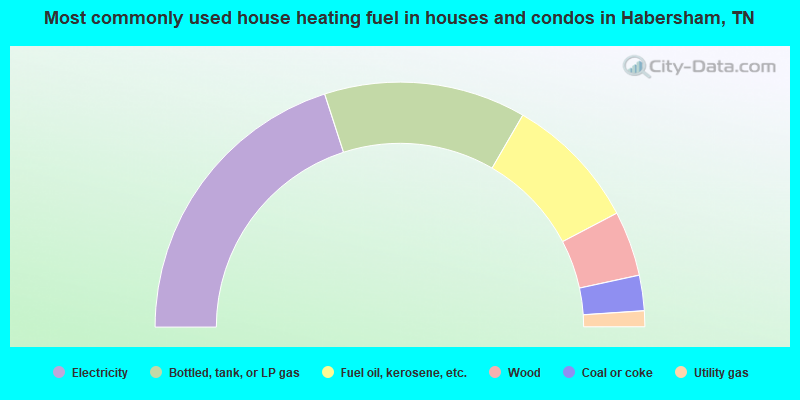
- 40.1%Electricity
- 26.7%Bottled, tank, or LP gas
- 17.9%Fuel oil, kerosene, etc.
- 8.6%Wood
- 4.7%Coal or coke
- 2.1%Utility gas
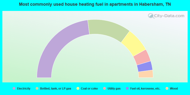
- 45.9%Electricity
- 24.3%Bottled, tank, or LP gas
- 13.5%Coal or coke
- 6.9%Utility gas
- 5.0%Fuel oil, kerosene, etc.
- 4.2%Wood
Habersham compared to Tennessee state average:
- Median household income below state average.
- Median house value significantly below state average.
- Black race population percentage significantly below state average.
- Hispanic race population percentage significantly below state average.
- Foreign-born population percentage significantly below state average.
- Renting percentage significantly below state average.
- Length of stay since moving in significantly above state average.
- Number of rooms per house significantly below state average.
- House age significantly below state average.
- Number of college students below state average.
- Percentage of population with a bachelor's degree or higher significantly below state average.