Harrisburg, South Dakota
Submit your own pictures of this city and show them to the world
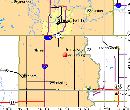
- OSM Map
- General Map
- Google Map
- MSN Map
Population change since 2000: +782.2%
| Males: 4,273 | |
| Females: 4,178 |
| Median resident age: | 31.1 years |
| South Dakota median age: | 38.5 years |
Zip codes: 57032.
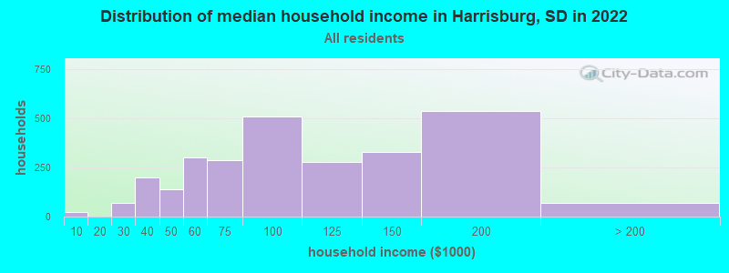
| Harrisburg: | $88,293 |
| SD: | $69,728 |
Estimated per capita income in 2022: $34,900 (it was $17,414 in 2000)
Harrisburg city income, earnings, and wages data
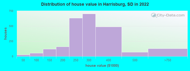
Estimated median house or condo value in 2022: $297,924 (it was $94,600 in 2000)
| Harrisburg: | $297,924 |
| SD: | $245,000 |
Mean prices in 2022: all housing units: $283,670; detached houses: $280,085; townhouses or other attached units: $297,648
Median gross rent in 2022: $1,088.
(2.4% for White Non-Hispanic residents, 0.3% for two or more races residents)
Detailed information about poverty and poor residents in Harrisburg, SD

Compare current foreclosures near Harrisburg, SD:
| Photo | Address | Area | Beds / Baths | Price | Details |
|---|---|---|---|---|---|

|
#1
E Maple St
Harrisburg, SD 57032
|
884 sq. feet
|
1 baths 2 beds |
show details | |

|
#2
Greyhawk Ct
Harrisburg, SD 57032
|
2,375 sq. feet
|
4 baths 4 beds |
show details | |

|
#3
N Cliff Ave
Harrisburg, SD 57032
|
- sq. feet
|
- baths - beds |
show details | |

|
#4
S Shebal Ave Unit B
Harrisburg, SD 57032
|
- sq. feet
|
- baths - beds |
show details | |

|
#5
S Cliff Ave Apt 804
Harrisburg, SD 57032
|
- sq. feet
|
- baths - beds |
show details | |

|
#6
Cottonwood Dr
Harrisburg, SD 57032
|
- sq. feet
|
- baths - beds |
show details | |

|
#7
Vernon Dr, Unit 1
Harrisburg, SD 57032
|
- sq. feet
|
- baths - beds |
show details | |

|
#8
W Elm St, Unit 6
Harrisburg, SD 57032
|
- sq. feet
|
- baths - beds |
show details | |

|
#9
N Dubuque Ave
Sioux Falls, SD 57110
|
1,132 sq. feet
|
1 baths 2 beds |
show details | |

|
#10
S Phillips Ave
Sioux Falls, SD 57105
|
884 sq. feet
|
1 baths 2 beds |
show details |
| Photo | Address | Area | Beds / Baths | Price | Details |
|---|---|---|---|---|---|

|
#11
S Jessica Ave
Sioux Falls, SD 57103
|
936 sq. feet
|
1 baths 2 beds |
show details | |

|
#12
W 26th St
Sioux Falls, SD 57105
|
1,357 sq. feet
|
5 baths 3 beds |
show details | |

|
#13
W Madison St
Sioux Falls, SD 57104
|
1,289 sq. feet
|
3 baths 3 beds |
show details | |

|
#14
E 24th St
Sioux Falls, SD 57103
|
1,372 sq. feet
|
3 baths 3 beds |
show details | |

|
#15
S Duluth Ave
Sioux Falls, SD 57105
|
1,080 sq. feet
|
3 baths 2 beds |
show details | |

|
#16
S Holbrook Ave
Sioux Falls, SD 57106
|
1,308 sq. feet
|
3 baths 3 beds |
show details | |

|
#17
E Belmont St
Sioux Falls, SD 57110
|
2,058 sq. feet
|
4 baths 3 beds |
show details | |

|
#18
N Blauvelt Ave
Sioux Falls, SD 57103
|
1,721 sq. feet
|
3 baths 2 beds |
show details | |

|
#19
S 4th Ave
Sioux Falls, SD 57105
|
2,187 sq. feet
|
3 baths 3 beds |
show details | |

|
#20
E Belmont St
Sioux Falls, SD 57110
|
1,612 sq. feet
|
3 baths 2 beds |
show details |
| Photo | Address | Area | Beds / Baths | Price | Details |
|---|---|---|---|---|---|

|
#21
W Mcclellan St
Sioux Falls, SD 57104
|
912 sq. feet
|
3 baths 2 beds |
show details | |

|
#22
W Lavern Wipf St
Sioux Falls, SD 57106
|
1,132 sq. feet
|
2 baths 2 beds |
show details | |

|
#23
N Main Ave
Sioux Falls, SD 57104
|
680 sq. feet
|
2 baths 2 beds |
show details | |

|
#24
S Tayberry Ave
Sioux Falls, SD 57106
|
2,092 sq. feet
|
3 baths 3 beds |
show details | |

|
#25
W 10th St # 7
Sioux Falls, SD 57107
|
1,448 sq. feet
|
3 baths 2 beds |
show details | |

|
#26
W Chickadee Pl
Sioux Falls, SD 57107
|
1,216 sq. feet
|
3 baths 3 beds |
show details | |

|
#27
N Pelican Pl
Sioux Falls, SD 57107
|
1,064 sq. feet
|
3 baths 3 beds |
show details | |

|
#28
W Paradise Pl
Sioux Falls, SD 57107
|
1,275 sq. feet
|
3 baths 3 beds |
show details | |

|
#29
N Mgm Pl
Sioux Falls, SD 57104
|
1,560 sq. feet
|
3 baths 3 beds |
show details | |

|
#30
S Oxford Ave
Sioux Falls, SD 57106
|
1,728 sq. feet
|
3 baths 2 beds |
show details |
| Photo | Address | Area | Beds / Baths | Price | Details |
|---|---|---|---|---|---|

|
#31
W 52nd St
Sioux Falls, SD 57106
|
1,994 sq. feet
|
3 baths 2 beds |
show details | |

|
#32
N Euclid Ave
Sioux Falls, SD 57104
|
1,118 sq. feet
|
2 baths 3 beds |
show details | |

|
#33
N Indiana Ave
Sioux Falls, SD 57103
|
1,042 sq. feet
|
3 baths 2 beds |
show details | |

|
#34
S Terry Ave
Sioux Falls, SD 57106
|
1,496 sq. feet
|
3 baths 3 beds |
show details | |

|
#35
E 3rd St Apt 6
Sioux Falls, SD 57110
|
1,060 sq. feet
|
2 baths 2 beds |
show details | |

|
#36
N Duluth Ave
Sioux Falls, SD 57104
|
1,149 sq. feet
|
2 baths 3 beds |
show details | |

|
#37
E 19th St
Sioux Falls, SD 57103
|
1,808 sq. feet
|
3 baths 3 beds |
show details | |

|
#38
N Lowell Ave
Sioux Falls, SD 57103
|
1,780 sq. feet
|
3 baths 3 beds |
show details | |

|
#39
S Edinborough Dr
Sioux Falls, SD 57106
|
1,784 sq. feet
|
4 baths 3 beds |
show details | |

|
#40
S Point Dr
Sioux Falls, SD 57103
|
1,596 sq. feet
|
3 baths 3 beds |
show details |
| Photo | Address | Area | Beds / Baths | Price | Details |
|---|---|---|---|---|---|

|
#41
S Clover Ave
Sioux Falls, SD 57110
|
1,554 sq. feet
|
3 baths 3 beds |
show details | |

|
#42
S Bruce Rd
Sioux Falls, SD 57105
|
1,482 sq. feet
|
3 baths 3 beds |
show details | |

|
#43
S Leah Cir
Sioux Falls, SD 57106
|
1,758 sq. feet
|
3 baths 3 beds |
show details | |

|
#44
W Mesa Pass
Sioux Falls, SD 57106
|
1,228 sq. feet
|
2 baths 3 beds |
show details | |

|
#45
W 53rd St
Sioux Falls, SD 57106
|
1,808 sq. feet
|
3 baths 3 beds |
show details | |

|
#46
S Samantha Dr
Sioux Falls, SD 57106
|
1,480 sq. feet
|
3 baths 2 beds |
show details | |

|
#47
S Cathy Ave
Sioux Falls, SD 57106
|
1,724 sq. feet
|
4 baths 3 beds |
show details | |

|
#48
482nd Ave
Brandon, SD 57005
|
3,056 sq. feet
|
5 baths 4 beds |
show details | |

|
#49
S Foster Ave
Sioux Falls, SD 57103
|
1,240 sq. feet
|
2 baths 3 beds |
show details | |

|
Check over 1 million property listings on Foreclosure.com!
|
browse all offers | |||


- 6,78192.7%White alone
- 2132.9%Hispanic
- 1912.6%Two or more races
- 1061.4%Asian alone
- 80.1%American Indian alone
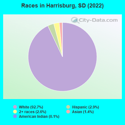
Races in Harrisburg detailed stats: ancestries, foreign born residents, place of birth
According to our research of South Dakota and other state lists, there were 7 registered sex offenders living in Harrisburg, South Dakota as of April 28, 2024.
The ratio of all residents to sex offenders in Harrisburg is 745 to 1.
The ratio of registered sex offenders to all residents in this city is much lower than the state average.
 Recent articles from our blog. Our writers, many of them Ph.D. graduates or candidates, create easy-to-read articles on a wide variety of topics.

 | City/Town Recommendations (4 replies) |
| Small town around Sioux Falls? Recommendations? (18 replies) |
| SE Sioux Falls or Brandon? (5 replies) |
| My short experience in Sioux Falls (61 replies) |
| Looks so Pretty (1 reply) |
| Harrisburg vs. Tea (9 replies) |
Latest news from Harrisburg, SD collected exclusively by city-data.com from local newspapers, TV, and radio stations
Ancestries: German (24.3%), Dutch (11.5%), European (9.6%), English (6.3%), American (5.8%), Norwegian (4.9%).
Current Local Time: CST time zone
Elevation: 1428 feet
Land area: 0.91 square miles.
Population density: 9,282 people per square mile (high).
211 residents are foreign born (1.6% Asia, 1.0% Latin America).
| This city: | 2.7% |
| South Dakota: | 3.8% |
Median real estate property taxes paid for housing units with mortgages in 2022: $3,562 (1.2%)
Median real estate property taxes paid for housing units with no mortgage in 2022: $2,499 (0.9%)
Nearest city with pop. 50,000+: Sioux Falls, SD  (7.6 miles , pop. 123,975).
Nearest city with pop. 200,000+: Omaha, NE (154.0 miles , pop. 390,007).
Nearest city with pop. 1,000,000+: Chicago, IL (471.5 miles , pop. 2,896,016).
Nearest cities:
), ), ), ), Latitude: 43.43 N, Longitude: 96.70 W
Area code commonly used in this area: 605
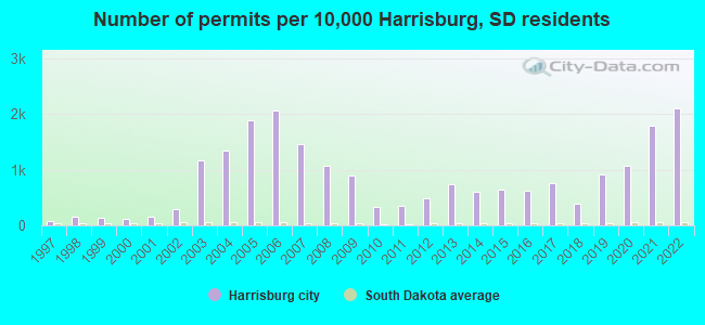
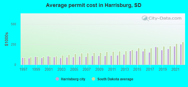
Single-family new house construction building permits:
- 2022: 201 buildings, average cost: $254,100
- 2021: 172 buildings, average cost: $229,900
- 2020: 103 buildings, average cost: $196,700
- 2019: 88 buildings, average cost: $181,400
- 2018: 37 buildings, average cost: $221,100
- 2017: 72 buildings, average cost: $152,800
- 2016: 60 buildings, average cost: $167,000
- 2015: 62 buildings, average cost: $172,600
- 2014: 57 buildings, average cost: $173,100
- 2013: 71 buildings, average cost: $128,100
- 2012: 46 buildings, average cost: $116,700
- 2011: 34 buildings, average cost: $113,400
- 2010: 32 buildings, average cost: $111,800
- 2009: 85 buildings, average cost: $111,200
- 2008: 102 buildings, average cost: $110,600
- 2007: 139 buildings, average cost: $100,900
- 2006: 197 buildings, average cost: $103,800
- 2005: 181 buildings, average cost: $97,300
- 2004: 129 buildings, average cost: $94,300
- 2003: 111 buildings, average cost: $87,200
- 2002: 28 buildings, average cost: $95,900
- 2001: 14 buildings, average cost: $106,500
- 2000: 11 buildings, average cost: $83,900
- 1999: 13 buildings, average cost: $100,400
- 1998: 15 buildings, average cost: $81,200
- 1997: 7 buildings, average cost: $89,700
| Here: | 1.6% |
| South Dakota: | 2.0% |
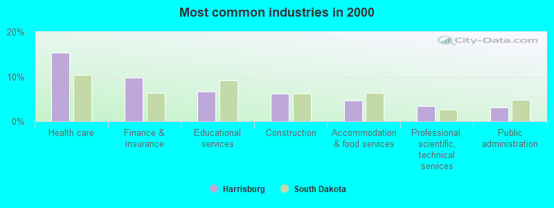
- Health care (15.3%)
- Finance & insurance (9.8%)
- Educational services (6.6%)
- Construction (6.3%)
- Accommodation & food services (4.7%)
- Professional, scientific, technical services (3.5%)
- Public administration (3.1%)
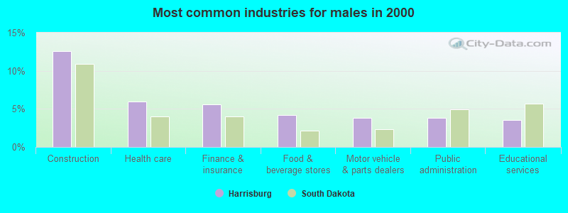
- Construction (12.6%)
- Health care (5.9%)
- Finance & insurance (5.6%)
- Food & beverage stores (4.2%)
- Motor vehicle & parts dealers (3.8%)
- Public administration (3.8%)
- Educational services (3.5%)
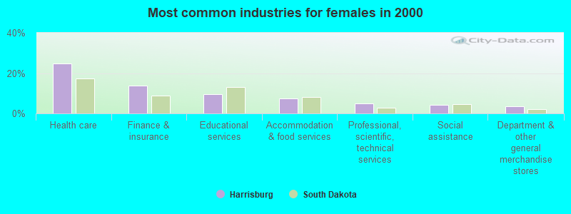
- Health care (24.7%)
- Finance & insurance (13.9%)
- Educational services (9.7%)
- Accommodation & food services (7.3%)
- Professional, scientific, technical services (4.9%)
- Social assistance (4.2%)
- Department & other general merchandise stores (3.5%)
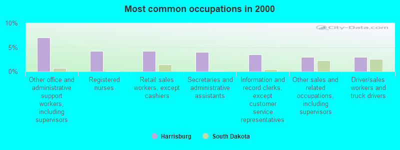
- Other office and administrative support workers, including supervisors (7.0%)
- Registered nurses (4.2%)
- Retail sales workers, except cashiers (4.2%)
- Secretaries and administrative assistants (4.0%)
- Information and record clerks, except customer service representatives (3.5%)
- Other sales and related occupations, including supervisors (3.0%)
- Driver/sales workers and truck drivers (3.0%)
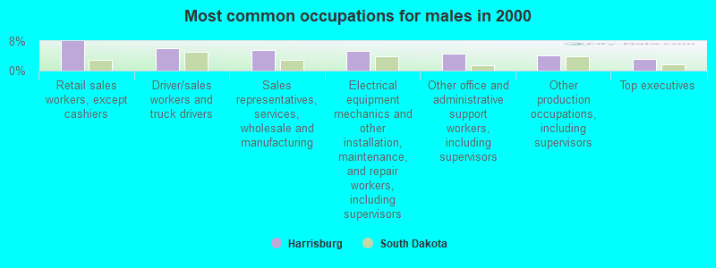
- Retail sales workers, except cashiers (8.0%)
- Driver/sales workers and truck drivers (5.9%)
- Sales representatives, services, wholesale and manufacturing (5.6%)
- Electrical equipment mechanics and other installation, maintenance, and repair workers, including supervisors (5.2%)
- Other office and administrative support workers, including supervisors (4.5%)
- Other production occupations, including supervisors (4.2%)
- Top executives (3.1%)
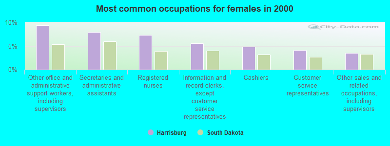
- Other office and administrative support workers, including supervisors (9.4%)
- Secretaries and administrative assistants (8.0%)
- Registered nurses (7.3%)
- Information and record clerks, except customer service representatives (5.6%)
- Cashiers (4.9%)
- Customer service representatives (4.2%)
- Other sales and related occupations, including supervisors (3.5%)
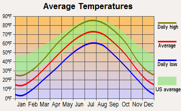
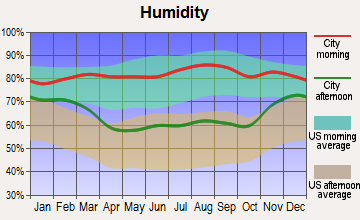
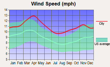
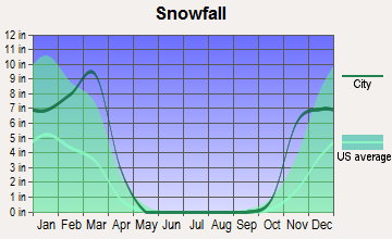
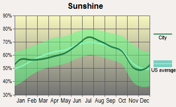
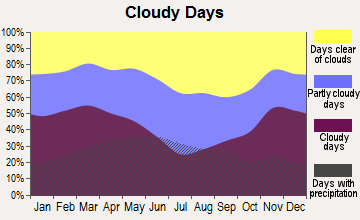
Average climate in Harrisburg, South Dakota
Based on data reported by over 4,000 weather stations
(lower is better)
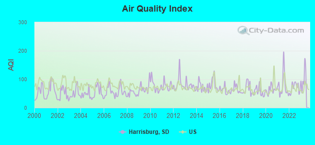
Air Quality Index (AQI) level in 2022 was 69.5. This is about average.
| City: | 69.5 |
| U.S.: | 72.6 |
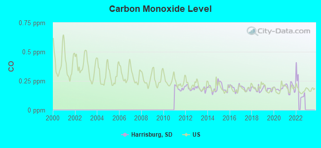
Carbon Monoxide (CO) [ppm] level in 2022 was 0.195. This is better than average. Closest monitor was 8.2 miles away from the city center.
| City: | 0.195 |
| U.S.: | 0.251 |
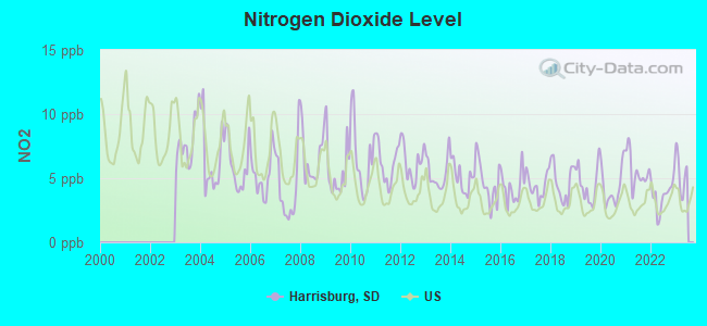
Nitrogen Dioxide (NO2) [ppb] level in 2022 was 3.69. This is better than average. Closest monitor was 7.5 miles away from the city center.
| City: | 3.69 |
| U.S.: | 5.11 |
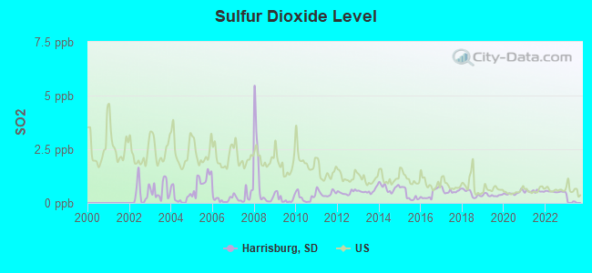
Sulfur Dioxide (SO2) [ppb] level in 2022 was 0.525. This is significantly better than average. Closest monitor was 7.5 miles away from the city center.
| City: | 0.525 |
| U.S.: | 1.515 |
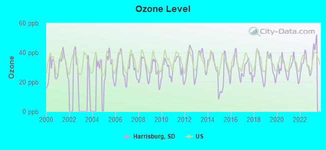
Ozone [ppb] level in 2022 was 31.5. This is about average. Closest monitor was 7.5 miles away from the city center.
| City: | 31.5 |
| U.S.: | 33.3 |

Particulate Matter (PM10) [µg/m3] level in 2022 was 20.6. This is about average. Closest monitor was 6.5 miles away from the city center.
| City: | 20.6 |
| U.S.: | 19.2 |
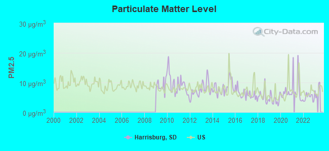
Particulate Matter (PM2.5) [µg/m3] level in 2022 was 5.03. This is significantly better than average. Closest monitor was 7.5 miles away from the city center.
| City: | 5.03 |
| U.S.: | 8.11 |
Tornado activity:
Harrisburg-area historical tornado activity is above South Dakota state average. It is 95% greater than the overall U.S. average.
On 6/7/1993, a category F4 (max. wind speeds 207-260 mph) tornado 23.0 miles away from the Harrisburg city center injured 5 people and caused between $5,000,000 and $50,000,000 in damages.
On 6/7/1965, a category F4 tornado 23.3 miles away from the city center killed one person and caused between $500,000 and $5,000,000 in damages.
Earthquake activity:
Harrisburg-area historical earthquake activity is significantly above South Dakota state average. It is 186% greater than the overall U.S. average.On 3/4/1983 at 06:32:18, a magnitude 4.6 (4.4 MB, 4.6 LG, 4.4 ML, Class: Light, Intensity: IV - V) earthquake occurred 145.8 miles away from Harrisburg center
On 7/9/1975 at 14:54:15, a magnitude 4.6 (4.6 MB) earthquake occurred 158.2 miles away from the city center
On 11/3/2002 at 20:41:56, a magnitude 4.3 (4.3 MB, Depth: 3.1 mi) earthquake occurred 120.1 miles away from the city center
On 10/25/1990 at 06:25:25, a magnitude 3.9 (3.6 MB, 3.9 LG, Depth: 3.1 mi, Class: Light, Intensity: II - III) earthquake occurred 92.4 miles away from the city center
On 8/18/1959 at 06:37:13, a magnitude 7.7 (7.7 UK, Class: Major, Intensity: VIII - XII) earthquake occurred 698.1 miles away from the city center, causing $26,000,000 total damage
On 6/5/1993 at 01:24:53, a magnitude 4.1 (4.1 LG, Depth: 6.2 mi) earthquake occurred 156.5 miles away from Harrisburg center
Magnitude types: regional Lg-wave magnitude (LG), body-wave magnitude (MB), local magnitude (ML)
Natural disasters:
The number of natural disasters in Lincoln County (14) is near the US average (15).Major Disasters (Presidential) Declared: 10
Emergencies Declared: 2
Causes of natural disasters: Floods: 9, Storms: 7, Tornadoes: 4, Winter Storms: 3, Snowstorms: 2, Blizzard: 1, Drought: 1, Hurricane: 1, Other: 1 (Note: some incidents may be assigned to more than one category).
Hospitals and medical centers near Harrisburg:
- COMPASSIONATE CARE HOSPICE (Hospital, about 3 miles away; SIOUX FALLS, SD)
- AVERA HEART HOSPITAL OF SOUTH DAKOTA Acute Care Hospitals (about 5 miles away; SIOUX FALLS, SD)
- AMEDISYS HOME HEALTH OF SIOUX FALLS (Home Health Center, about 6 miles away; SIOUX FALLS, SD)
- AVERA MCKENNAN HOSPICE AND PALLIATIVE CARE (Hospital, about 6 miles away; SIOUX FALLS, SD)
- AVERA PRINCE OF PEACE (Nursing Home, about 6 miles away; SIOUX FALLS, SD)
- PRINCE OF PEACE RETIREMENT COMMUNITY (Nursing Home, about 6 miles away; SIOUX FALLS, SD)
- INTERIM HEALTHCARE (Home Health Center, about 6 miles away; SIOUX FALLS, SD)
Colleges/universities with over 2000 students nearest to Harrisburg:
- Southeast Technical Institute (about 11 miles; Sioux Falls, SD; Full-time enrollment: 2,386)
- University of South Dakota (about 47 miles; Vermillion, SD; FT enrollment: 7,328)
- South Dakota State University (about 62 miles; Brookings, SD; FT enrollment: 10,392)
- Western Iowa Tech Community College (about 68 miles; Sioux City, IA; FT enrollment: 3,544)
- Wayne State College (about 84 miles; Wayne, NE; FT enrollment: 3,121)
- Southwest Minnesota State University (about 85 miles; Marshall, MN; FT enrollment: 3,711)
- Buena Vista University (about 93 miles; Storm Lake, IA; FT enrollment: 2,522)
Public high school in Harrisburg:
- HARRISBURG HIGH SCHOOL - 01 (Students: 295, Location: 1300 W. WILLOW ST., Grades: 9-12)
Public elementary/middle schools in Harrisburg:
- HARRISBURG SOUTH MIDDLE SCHOOL - 03 (Students: 408, Location: 600 S. CLIFF AVE., Grades: 6-8)
- LIBERTY ELEMENTARY - 02 (Location: 200 WILLOW ST, Grades: PK-5)
- FREEDOM ELEM - 06 (Location: 1101 TOM SAWYER TRAIL, Grades: PK-5)
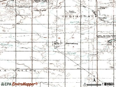
Points of interest:
Notable locations in Harrisburg: Harrisburg Fire Department (A), Harrisburg City Hall (B), Harrisburg Community Library (C). Display/hide their locations on the map
Drinking water stations with addresses in Harrisburg that have no violations reported:
- LINCOLN COUNTY RURAL WATER SYSTEM (Population served: 5,425, Primary Water Source Type: Purch groundwater)
- LINCOLN COUNTY RURAL WATER SYSTEM (Population served: 5,425, Primary Water Source Type: Purch groundwater)
- HARRISBURG (Population served: 4,089, Primary Water Source Type: Purch groundwater)
| This city: | 2.9 people |
| South Dakota: | 2.4 people |
| This city: | 79.6% |
| Whole state: | 64.2% |
| This city: | 8.9% |
| Whole state: | 6.5% |
Likely homosexual households (counted as self-reported same-sex unmarried-partner households)
- Lesbian couples: 0.2% of all households
- Gay men: 0.4% of all households
Banks with branches in Harrisburg (2011 data):
- Home Federal Bank: Harrisburg Branch at 220 S. Cliff Avenue, Suite 126, branch established on 2005/10/19. Info updated 2011/07/21: Bank assets: $1,224.2 mil, Deposits: $946.5 mil, headquarters in Sioux Falls, SD, positive income, Commercial Lending Specialization, 34 total offices
- The First National Bank in Sioux Falls: Harrisburg Branch at 408 North Cliff Avenue, branch established on 2004/12/21. Info updated 2007/05/31: Bank assets: $1,054.1 mil, Deposits: $755.9 mil, headquarters in Sioux Falls, SD, positive income, 18 total offices, Holding Company: Minnehaha Banshares, Inc.
For population 15 years and over in Harrisburg:
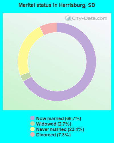
- Never married: 23.4%
- Now married: 66.7%
- Separated: 0.0%
- Widowed: 2.7%
- Divorced: 7.3%
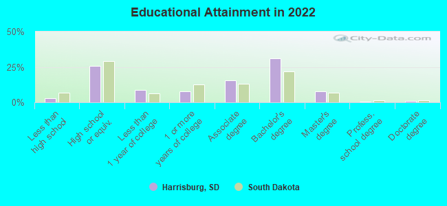
For population 25 years and over in Harrisburg:
- High school or higher: 97.2%
- Bachelor's degree or higher: 40.0%
- Graduate or professional degree: 7.2%
- Unemployed: 2.2%
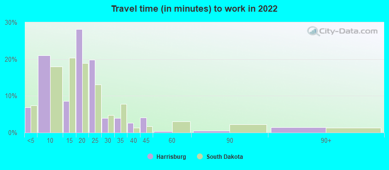
- Mean travel time to work (commute): 11.9 minutes
| Here: | 9.8 |
| South Dakota average: | 10.5 |
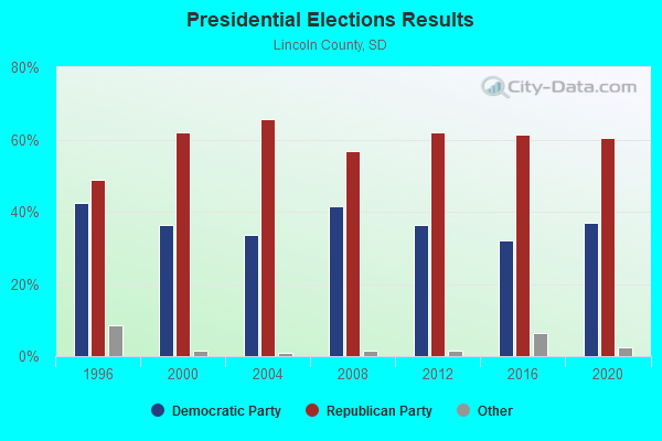
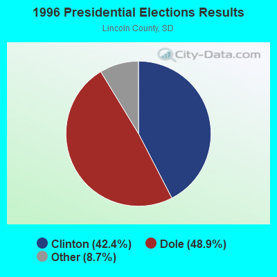
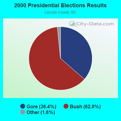
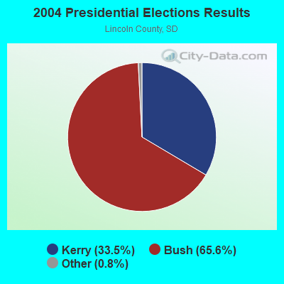
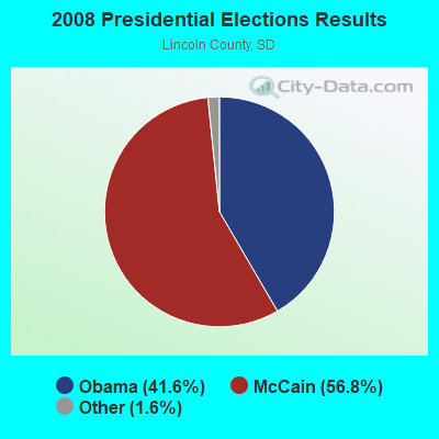
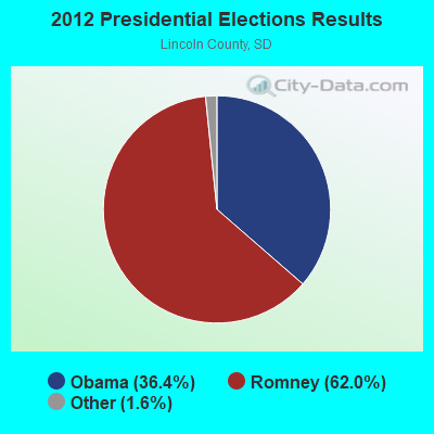
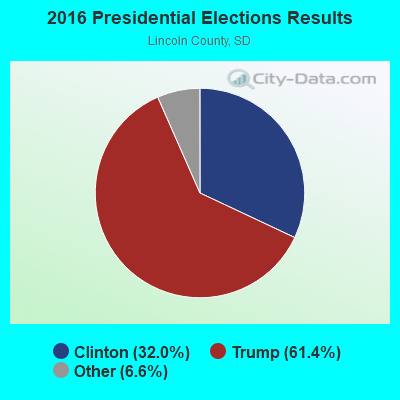

Graphs represent county-level data. Detailed 2008 Election Results
Religion statistics for Harrisburg, SD (based on Lincoln County data)
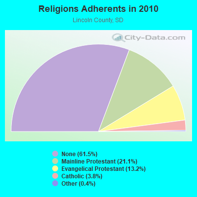
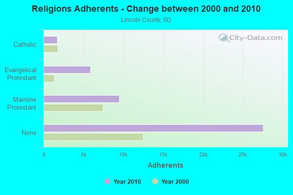
| Religion | Adherents | Congregations |
|---|---|---|
| Mainline Protestant | 9,459 | 19 |
| Evangelical Protestant | 5,901 | 26 |
| Catholic | 1,706 | 4 |
| Other | 189 | 1 |
| None | 27,573 | - |
Food Environment Statistics:
| Lincoln County: | 1.06 / 10,000 pop. |
| State: | 2.84 / 10,000 pop. |
| Lincoln County: | 0.27 / 10,000 pop. |
| State: | 0.65 / 10,000 pop. |
| Lincoln County: | 4.51 / 10,000 pop. |
| South Dakota: | 6.68 / 10,000 pop. |
| Lincoln County: | 5.30 / 10,000 pop. |
| State: | 9.21 / 10,000 pop. |
| This county: | 5.2% |
| State: | 7.7% |
| This county: | 25.1% |
| State: | 27.7% |
| Here: | 13.1% |
| South Dakota: | 14.9% |
Health and Nutrition:
| This city: | 61.7% |
| State: | 51.4% |
| Harrisburg: | 67.6% |
| South Dakota: | 49.4% |
| Here: | 26.8 |
| South Dakota: | 28.5 |
| Harrisburg: | 16.9% |
| State: | 20.6% |
| Here: | 5.3% |
| State: | 9.7% |
| This city: | 7.1 |
| South Dakota: | 6.9 |
| This city: | 28.7% |
| State: | 34.1% |
| Here: | 70.6% |
| South Dakota: | 58.1% |
| This city: | 86.5% |
| South Dakota: | 78.7% |
More about Health and Nutrition of Harrisburg, SD Residents
| Local government employment and payroll (March 2022) | |||||
| Function | Full-time employees | Monthly full-time payroll | Average yearly full-time wage | Part-time employees | Monthly part-time payroll |
|---|---|---|---|---|---|
| Streets and Highways | 3 | $15,925 | $63,700 | 1 | $2,028 |
| Financial Administration | 2 | $10,704 | $64,224 | 0 | $0 |
| Other Government Administration | 2 | $15,099 | $90,594 | 17 | $3,739 |
| Water Supply | 2 | $10,832 | $64,992 | 0 | $0 |
| Sewerage | 1 | $5,219 | $62,628 | 0 | $0 |
| Parks and Recreation | 1 | $4,440 | $53,280 | 1 | $1,025 |
| Other and Unallocable | 0 | $0 | 3 | $2,502 | |
| Local Libraries | 0 | $0 | 6 | $8,919 | |
| Totals for Government | 11 | $62,219 | $67,875 | 28 | $18,214 |
Harrisburg government finances - Expenditure in 2021 (per resident):
- Current Operations - Sewerage: $1,687,000 ($199.62)
Central Staff Services: $604,000 ($71.47)
Regular Highways: $542,000 ($64.13)
Water Utilities: $439,000 ($51.95)
General - Other: $376,000 ($44.49)
Police Protection: $301,000 ($35.62)
Financial Administration: $232,000 ($27.45)
Parks and Recreation: $206,000 ($24.38)
Local Fire Protection: $64,000 ($7.57)
Libraries: $62,000 ($7.34)
Protective Inspection and Regulation - Other: $32,000 ($3.79)
Health - Other: $29,000 ($3.43)
Solid Waste Management: $11,000 ($1.30)
- General - Interest on Debt: $178,000 ($21.06)
- Water Utilities - Interest on Debt: $115,000 ($13.61)
Harrisburg government finances - Revenue in 2021 (per resident):
- Charges - Sewerage: $1,693,000 ($200.33)
Parks and Recreation: $48,000 ($5.68)
Other: $26,000 ($3.08)
Solid Waste Management: $2,000 ($0.24)
- Federal Intergovernmental - Other: $1,000 ($0.12)
- Miscellaneous - General Revenue - Other: $616,000 ($72.89)
Sale of Property: $90,000 ($10.65)
Interest Earnings: $43,000 ($5.09)
Donations From Private Sources: $17,000 ($2.01)
Fines and Forfeits: $5,000 ($0.59)
Rents: $3,000 ($0.35)
- Revenue - Water Utilities: $943,000 ($111.58)
- State Intergovernmental - Other: $216,000 ($25.56)
General Local Government Support: $89,000 ($10.53)
Highways: $15,000 ($1.77)
- Tax - General Sales and Gross Receipts: $1,759,000 ($208.14)
Property: $1,351,000 ($159.86)
Other License: $185,000 ($21.89)
Amusements Sales: $1,000 ($0.12)
Harrisburg government finances - Debt in 2021 (per resident):
- Long Term Debt - Beginning Outstanding - Unspecified Public Purpose: $9,502,000 ($1124.36)
Outstanding Unspecified Public Purpose: $9,042,000 ($1069.93)
Retired Unspecified Public Purpose: $460,000 ($54.43)
Beginning Outstanding - Public Debt for Private Purpose: $99,000 ($11.71)
Retired Nonguaranteed - Public Debt for Private Purpose: $99,000 ($11.71)
Harrisburg government finances - Cash and Securities in 2021 (per resident):
- Bond Funds - Cash and Securities: $1,029,000 ($121.76)
- Other Funds - Cash and Securities: $7,223,000 ($854.69)
- Sinking Funds - Cash and Securities: $108,000 ($12.78)
Businesses in Harrisburg, SD
- Subway: 1
Strongest AM radio stations in Harrisburg:
- KSOO (1140 AM; 10 kW; SIOUX FALLS, SD; Owner: SOUTHERN MINNESOTA BROADCASTING CO.)
- KXRB (1000 AM; 10 kW; SIOUX FALLS, SD)
- KELO (1320 AM; 5 kW; SIOUX FALLS, SD; Owner: MIDCONTINENT RADIO OF S.D., INC.)
- KWSN (1230 AM; 1 kW; SIOUX FALLS, SD; Owner: MIDCONTINENT RADIO OF S.D., INC.)
- KNWC (1270 AM; 5 kW; SIOUX FALLS, SD; Owner: NORTHWESTERN COLLEGE)
- KLOH (1050 AM; 9 kW; PIPESTONE, MN; Owner: WALLACE CHRISTENSEN)
- WNAX (570 AM; 5 kW; YANKTON, SD; Owner: SAGA COMMUNICATIONS, INC.)
- KSQB (1520 AM; daytime; 0 kW; SIOUX FALLS, SD; Owner: L A SKYWAVE, INC.)
- KFAB (1110 AM; 50 kW; OMAHA, NE; Owner: CAPSTAR TX LIMITED PARTNERSHIP)
- KOIL (1020 AM; 50 kW; PLATTSMOUTH, NE; Owner: WAITT RADIO, INC.)
- KKAR (1290 AM; 50 kW; OMAHA, NE; Owner: WAITT RADIO, INC.)
- WCCO (830 AM; 50 kW; MINNEAPOLIS, MN; Owner: INFINITY MEDIA CORPORATION)
- KFAN (1130 AM; 50 kW; MINNEAPOLIS, MN; Owner: AMFM RADIO LICENSES, L.L.C.)
Strongest FM radio stations in Harrisburg:
- KELO-FM (92.5 FM; SIOUX FALLS, SD; Owner: MIDCONTINENT RADIO OF SOUTH DAKOTA, INC.)
- KNWC-FM (96.5 FM; SIOUX FALLS, SD; Owner: NORTHWESTERN COLLEGE)
- KYBB (102.7 FM; CANTON, SD; Owner: SOUTHERN MINNESOTA B/C COMPANY)
- KMXC (97.3 FM; SIOUX FALLS, SD; Owner: SOUTHERN MINNESOTA BROADCASTING CO.)
- KRRO (103.7 FM; SIOUX FALLS, SD; Owner: MIDCONTINENT RADIO OF S.D., INC.)
- KAUR (89.1 FM; SIOUX FALLS, SD; Owner: AUGUSTANA COLLEGE ASSOCIATION)
- KRSD (88.1 FM; SIOUX FALLS, SD; Owner: MINNESOTA PUBLIC RADIO)
- KCFS (94.5 FM; SIOUX FALLS, SD; Owner: UNIVERSITY OF SIOUX FALLS)
- KCSD (90.9 FM; SIOUX FALLS, SD; Owner: UNIVERSITY OF SIOUX FALLS)
- KKLS-FM (104.7 FM; SIOUX FALLS, SD; Owner: SOUTHERN MINNESOTA BROADCASTING CO.)
- K261CI (100.1 FM; SIOUX FALLS, SD; Owner: SOUTHERN MINNESOTA B/CNG COMPANY)
- KLQL (101.1 FM; LUVERNE, MN; Owner: THREE EAGLES OF LUVERNE, INC.)
- KUSD (89.7 FM; VERMILLION, SD; Owner: S/DAKOTA BD OF DIR FOR ED. TELECOMUN)
- KTWB (101.9 FM; SIOUX FALLS, SD; Owner: MIDCONTINENT RADIO OF SOUTH DAKOTA, INC.)
- KIKN-FM (100.5 FM; SALEM, SD; Owner: SOUTHERN MINNESOTA B/CNG. COMPANY)
- KVCF (90.5 FM; FREEMAN, SD; Owner: VCY AMERICA, INC.)
- KKHG (107.9 FM; FLANDREAU, SD; Owner: LA COMMUNIQUE, INC.)
- K252DG (98.3 FM; SIOUX FALLS, SD; Owner: CHRISTIAN HERITAGE BROADCASTING, INC.)
- KSOU-FM (93.9 FM; SIOUX CENTER, IA; Owner: WMMP, LLC)
- KSQB-FM (95.7 FM; DELL RAPIDS, SD; Owner: L A RADIO, INC.)
TV broadcast stations around Harrisburg:
- KTTW (Channel 17; SIOUX FALLS, SD; Owner: INDEPENDENT COMMUNICATIONS, INC.)
- KELO-TV (Channel 11; SIOUX FALLS, SD; Owner: YOUNG BROADCASTING OF SIOUX FALLS, INC.)
- KDLT-TV (Channel 46; SIOUX FALLS, SD; Owner: RED RIVER BROADCAST CO., LLC)
- K67GH (Channel 67; OTTUMWA, IA; Owner: MS COMMUNICATIONS, LLC)
- KSFY-TV (Channel 13; SIOUX FALLS, SD; Owner: ELCOM OF SOUTH DAKOTA, INC.)
- KAUN (Channel 36; SIOUX FALLS, SD; Owner: RAPID BROADCASTING COMPANY)
- K53EG (Channel 53; SIOUX FALLS, SD; Owner: SIOUXLAND CHRISTIAN BROADCASTING)
- K56GF (Channel 56; SIOUX FALLS, SD; Owner: TRINITY BROADCASTING NETWORK)
- K48DK (Channel 48; SIOUX FALLS, SD; Owner: STUART E. MOEN)
- KDLV-TV (Channel 5; MITCHELL, SD; Owner: RED RIVER BROADCAST CO., LLC)
- KXWB-LP (Channel 42; SIOUX FALLS, SD; Owner: RAPID BROADCASTING COMPANY)
- KCSD-TV (Channel 23; SIOUX FALLS, SD; Owner: SOUTH DAKOTA BOARD OF DIRECTORS FOR ED. TELECOMMUNICATIONS)
- KUSD-TV (Channel 2; VERMILLION, SD; Owner: SOUTH DAKOTA BOARD OF DIRECTORS FOR ED. TELECOMMUNICATIONS)
- KCPO-LP (Channel 26; SIOUX FALLS, SD; Owner: G.I.G., INC.)
- KBNW-LP (Channel 44; SIOUX FALLS, SD; Owner: RAPID BROADCASTING COMPANY)
- K25AA (Channel 25; ROCK RAPIDS, ETC., IA; Owner: IOWA PUBLIC BROADCASTING BOARD)
- K52ES (Channel 52; NORFOLK, NE; Owner: TRINITY BROADCASTING NETWORK)
- National Bridge Inventory (NBI) Statistics
- 6Number of bridges
- 30ft / 9.0mTotal length
- $600,000Total costs
- 11,599Total average daily traffic
- 683Total average daily truck traffic
- 25,521Total future (year 2032) average daily traffic
FCC Registered Antenna Towers:
17 (See the full list of FCC Registered Antenna Towers in Harrisburg)FCC Registered Broadcast Land Mobile Towers:
5- 1300 E Willow St. (Lat: 43.434389 Lon: -96.719361), Type: Mast, Structure height: 13.7 m, Overall height: 16.7 m, Call Sign: WQDL256,
Assigned Frequencies: 72.1600 MHz, Grant Date: 06/30/2015, Expiration Date: 09/22/2025, Certifier: Rollin Fink, Registrant: Primex Wireless, Inc., 965 Wells Street, Lake Geneva, WI 53147, Phone: (262) 729-4858, Email:
- One Enterprise Street (Lat: 43.459833 Lon: -96.701667), Call Sign: WQDT527,
Assigned Frequencies: 462.225 MHz, 462.300 MHz, Grant Date: 10/26/2005, Expiration Date: 10/26/2015, Cancellation Date: 12/26/2015, Certifier: Andrew Gilbert, Registrant: Psion Teklogix, 1810 Airport Exchange Blvd, Erlanger, KY 41018, Phone: (859) 372-4266, Fax: (859) 372-4185, Email:
- Lat: 43.374222 Lon: -96.646861, Call Sign: WQOM204,
Assigned Frequencies: 468.237 MHz, Grant Date: 09/16/2021, Expiration Date: 11/14/2031, Certifier: Sherwood Beek, Registrant: Two Way Solutions Inc, 700 E. 3rd. St., Sioux Falls, SD 57103, Phone: (605) 334-9816, Fax: (605) 334-1554, Email:
- Lat: 43.427972 Lon: -96.705028, Call Sign: WRFB610,
Assigned Frequencies: 468.875 MHz, 463.875 MHz, 466.850 MHz, 461.850 MHz, Grant Date: 01/24/2020, Expiration Date: 01/24/2030, Certifier: Toby Huizenga, Registrant: Two Way Solutions Inc, 700 E 3rd St, Sioux Falls, SD 57103, Phone: (605) 334-9816, Fax: (605) 334-1554, Email:
- 47671 272nd St (Lat: 43.445361 Lon: -96.673722), Call Sign: WROX913,
Assigned Frequencies: 451.412 MHz, 452.412 MHz, Grant Date: 12/28/2021, Expiration Date: 12/28/2031, Certifier: Gaylon Johnson, Registrant: Two Way Solutions Inc, 700 E 3rd St, Sioux Falls, SD 57103, Phone: (605) 334-9816, Email:
FCC Registered Microwave Towers:
3- HARRISBURG, Lat: 43.429889 Lon: -96.696806, Call Sign: WQHJ770,
Assigned Frequencies: 956.431 MHz, Grant Date: 06/01/2017, Expiration Date: 08/16/2027, Certifier: Mary Mcclung, Registrant: Vantek Communications, 221 S Jessica Ave, Sioux Falls, SD 57103, Phone: (605) 996-1200, Fax: (605) 996-6206, Email:
- HARRISBURG, Lat: 43.430000 Lon: -96.698056, Call Sign: WQKP978,
Assigned Frequencies: 956.393 MHz, Grant Date: 08/07/2009, Expiration Date: 08/07/2019, Cancellation Date: 10/12/2019, Certifier: Robin Dykstra, Registrant: Sensus, 450 N Gallatin Avenue, Uniontown, PA 15401, Phone: (800) 638-3748, Fax: (800) 888-2403, Email:
- HARRISBURG, 715 Grand Ave (Lat: 43.423278 Lon: -96.695583), Type: Tower, Structure height: 57.9 m, Call Sign: WQLC287,
Assigned Frequencies: 10795.0 MHz, 10755.0 MHz, 10875.0 MHz, 10835.0 MHz, Grant Date: 12/01/2009, Expiration Date: 12/01/2019, Cancellation Date: 08/26/2013, Certifier: Joseph H Beran, Registrant: Lukas, Nace, Gutierrez & Sachs, LLP, 8300 Greensboro Drive, Suite 1200, Mclean, VA 22102, Phone: (703) 584-8661, Email:
FCC Registered Amateur Radio Licenses:
24 (See the full list of FCC Registered Amateur Radio Licenses in Harrisburg)FAA Registered Aircraft:
8 (See the full list of FAA Registered Aircraft in Harrisburg)2003 - 2018 National Fire Incident Reporting System (NFIRS) incidents
- Fire incident types reported to NFIRS in Harrisburg, SD
- 14251.6%Outside Fires
- 7426.9%Structure Fires
- 3713.5%Mobile Property/Vehicle Fires
- 228.0%Other
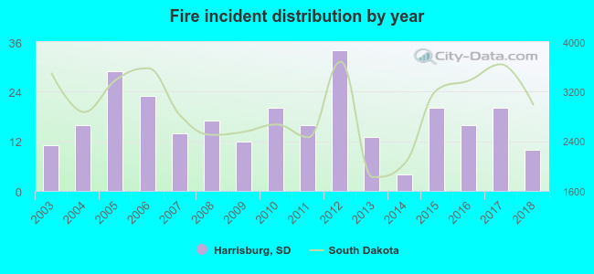 According to the data from the years 2003 - 2018 the average number of fire incidents per year is 17. The highest number of fires - 34 took place in 2012, and the least - 4 in 2014. The data has a declining trend.
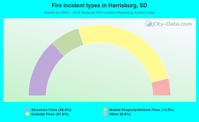 When looking into fire subcategories, the most incidents belonged to: Outside Fires (51.6%), and Structure Fires (26.9%).
| Most common first names in Harrisburg, SD among deceased individuals | ||
| Name | Count | Lived (average) |
|---|---|---|
| John | 7 | 62.6 years |
| William | 6 | 71.2 years |
| Robert | 6 | 60.7 years |
| Clarence | 5 | 77.6 years |
| Mary | 5 | 86.2 years |
| Harold | 5 | 70.8 years |
| George | 5 | 79.6 years |
| Joseph | 5 | 78.4 years |
| Herman | 4 | 77.2 years |
| Alfred | 4 | 80.3 years |
| Most common last names in Harrisburg, SD among deceased individuals | ||
| Last name | Count | Lived (average) |
|---|---|---|
| Harris | 6 | 72.0 years |
| Johnson | 5 | 81.8 years |
| Slack | 5 | 81.2 years |
| Olson | 5 | 82.2 years |
| Abbott | 4 | 71.5 years |
| Hill | 4 | 78.3 years |
| Timm | 4 | 73.3 years |
| Knabach | 4 | 86.2 years |
| Spielman | 4 | 74.5 years |
| Larson | 4 | 84.3 years |
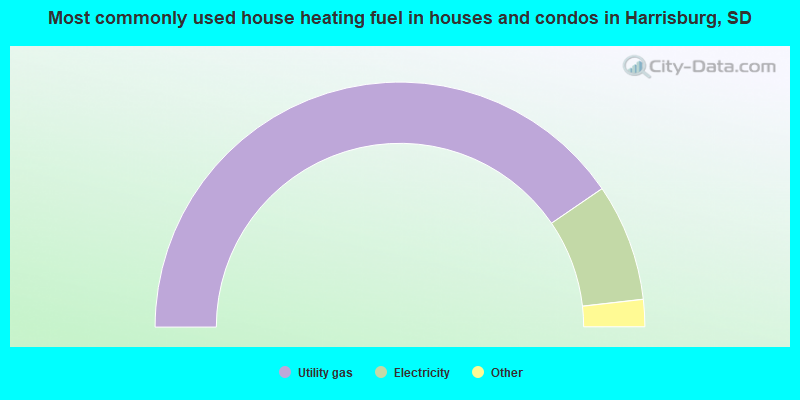
- 80.9%Utility gas
- 15.5%Electricity
- 2.4%Bottled, tank, or LP gas
- 1.1%No fuel used
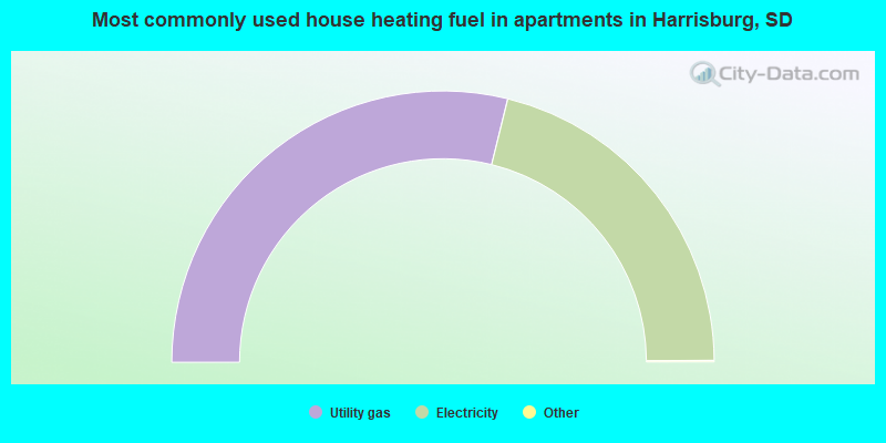
- 57.8%Utility gas
- 42.2%Electricity
Harrisburg compared to South Dakota state average:
- Unemployed percentage significantly below state average.
- Black race population percentage significantly below state average.
- Hispanic race population percentage significantly above state average.
- Foreign-born population percentage significantly above state average.
- Renting percentage below state average.
- Length of stay since moving in significantly above state average.
- House age significantly below state average.
- Number of college students significantly above state average.
- Percentage of population with a bachelor's degree or higher above state average.
Harrisburg on our top lists:
- #69 on the list of "Top 100 fastest growing cities from 2000 to 2014"
- #46 on the list of "Top 101 counties with the largest number of children under 18 without health insurance coverage in 2000"
- #49 on the list of "Top 101 counties with the highest percentage of residents relocating from other counties between 2010 and 2011"
- #58 on the list of "Top 101 counties with the lowest number of deaths per 1000 residents 2007-2013"
State forum archive:

|
|
Total of 48 patent applications in 2008-2024.