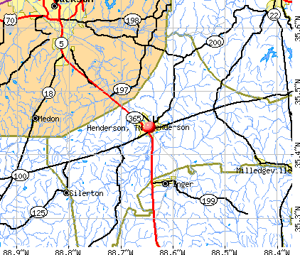
Henderson, Tennessee
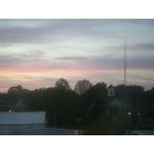
Henderson: The sunset over the court house
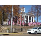
Henderson: Flags flying outside the County Courthouse on Veteran's Day November 11th, 2011
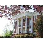
Henderson: Chester County Court House in Henderson, TN
- add
your
Submit your own pictures of this city and show them to the world
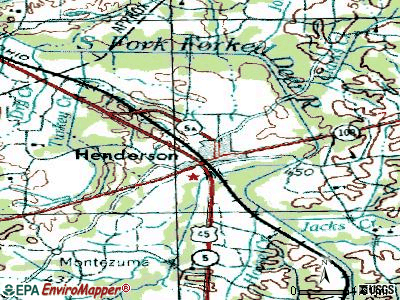
- OSM Map
- General Map
- Google Map
- MSN Map
Population change since 2000: +13.3%
 |
| Males: 3,063 | |
| Females: 3,360 |
| Median resident age: | 27.0 years |
| Tennessee median age: | 39.2 years |
Zip codes: 38340.
| Henderson: | $44,916 |
| TN: | $65,254 |
Estimated per capita income in 2022: $18,226 (it was $16,735 in 2000)
Henderson city income, earnings, and wages data
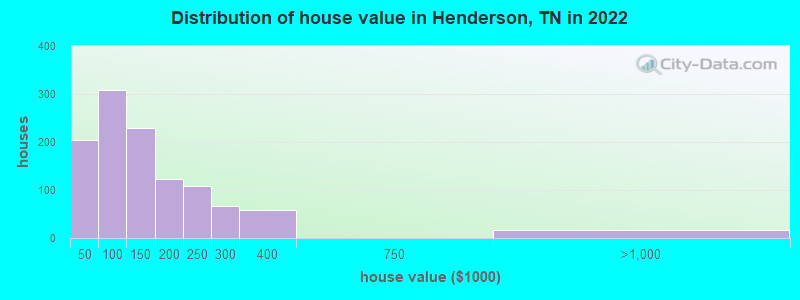
Estimated median house or condo value in 2022: $143,443 (it was $75,200 in 2000)
| Henderson: | $143,443 |
| TN: | $284,800 |
Mean prices in 2022: all housing units: $154,917; detached houses: $158,520; mobile homes: $53,392
Median gross rent in 2022: $703.
(14.8% for White Non-Hispanic residents, 43.0% for Black residents, 13.1% for Hispanic or Latino residents, 25.3% for two or more races residents)
Detailed information about poverty and poor residents in Henderson, TN


Compare current foreclosures in Henderson, TN:
| Photo | Address | Area | Beds / Baths | Price | Details |
|---|---|---|---|---|---|

|
#1
Harmony Ln
Henderson, TN 38340
|
1,730 sq. feet
|
2 baths - beds |
show details | |

|
#2
Village Way
Henderson, TN 38340
|
- sq. feet
|
2 baths - beds |
show details | |

|
#3
Barham Ln
Henderson, TN 38340
|
1,344 sq. feet
|
1 baths - beds |
show details | |

|
#4
Old Montezuma Rd
Henderson, TN 38340
|
1,200 sq. feet
|
1 baths - beds |
show details | |

|
#5
Fourth St
Henderson, TN 38340
|
1,092 sq. feet
|
1 baths - beds |
show details | |

|
#6
Sanford St
Henderson, TN 38340
|
1,305 sq. feet
|
2 baths - beds |
show details | |

|
#7
Mitchell Ln
Henderson, TN 38340
|
1,456 sq. feet
|
2 baths - beds |
show details | |

|
#8
Melodie Cir
Henderson, TN 38340
|
1,036 sq. feet
|
1 baths - beds |
show details | |

|
#9
Cedar Brook Ln
Henderson, TN 38340
|
1,519 sq. feet
|
2 baths - beds |
show details | |

|
#10
Sanford St
Henderson, TN 38340
|
1,066 sq. feet
|
1 baths - beds |
show details |
| Photo | Address | Area | Beds / Baths | Price | Details |
|---|---|---|---|---|---|

|
#11
Regina Dr
Henderson, TN 38340
|
1,200 sq. feet
|
2 baths - beds |
show details | |

|
#12
Cave Springs Rd
Henderson, TN 38340
|
999 sq. feet
|
1 baths - beds |
show details | |

|
#13
Beechwood St
Henderson, TN 38340
|
1,109 sq. feet
|
1 baths - beds |
show details | |

|
#14
Sand Ave
Henderson, TN 38340
|
1,305 sq. feet
|
3 baths - beds |
show details | |

|
#15
Baughn St
Henderson, TN 38340
|
1,056 sq. feet
|
1 baths - beds |
show details | |

|
#16
Old Jacks Creek Rd
Henderson, TN 38340
|
1,400 sq. feet
|
1 baths - beds |
show details | |

|
#17
Hill Ave
Henderson, TN 38340
|
1,694 sq. feet
|
1 baths - beds |
show details | |

|
#18
Morgan St
Henderson, TN 38340
|
1,314 sq. feet
|
2 baths - beds |
show details | |

|
#19
White Ave
Henderson, TN 38340
|
1,488 sq. feet
|
1 baths - beds |
show details | |

|
#20
Luray Ave
Henderson, TN 38340
|
1,124 sq. feet
|
1 baths - beds |
show details |
| Photo | Address | Area | Beds / Baths | Price | Details |
|---|---|---|---|---|---|

|
#21
Morgan St
Henderson, TN 38340
|
1,512 sq. feet
|
1 baths - beds |
show details | |

|
#22
Shelton Dr
Henderson, TN 38340
|
1,333 sq. feet
|
1 baths - beds |
show details | |

|
#23
Cooper Ln
Henderson, TN 38340
|
1,860 sq. feet
|
2 baths - beds |
show details | |

|
#24
Galbraith Ave
Henderson, TN 38340
|
2,138 sq. feet
|
2 baths - beds |
show details | |

|
#25
Cloud Cir
Henderson, TN 38340
|
1,067 sq. feet
|
1 baths - beds |
show details | |

|
#26
White Ave
Henderson, TN 38340
|
1,640 sq. feet
|
2 baths - beds |
show details | |

|
#27
Old Finger Rd
Henderson, TN 38340
|
1,344 sq. feet
|
2 baths - beds |
show details | |

|
#28
Hurst Rd
Henderson, TN 38340
|
1,344 sq. feet
|
1 baths - beds |
show details | |

|
#29
Wilson School Rd
Henderson, TN 38340
|
1,860 sq. feet
|
2 baths - beds |
show details | |

|
#30
North Ave
Henderson, TN 38340
|
- sq. feet
|
- baths - beds |
show details |
| Photo | Address | Area | Beds / Baths | Price | Details |
|---|---|---|---|---|---|

|
#31
Sanford St Apt 803
Henderson, TN 38340
|
- sq. feet
|
- baths - beds |
show details | |

|
#32
Mifflin Ave
Henderson, TN 38340
|
- sq. feet
|
- baths - beds |
show details | |

|
#33
Hughes Rd
Henderson, TN 38340
|
1,568 sq. feet
|
- baths - beds |
show details | |

|
#34
E University St Apt 514
Henderson, TN 38340
|
- sq. feet
|
- baths - beds |
show details | |

|
#35
State Route 100 W
Henderson, TN 38340
|
- sq. feet
|
- baths - beds |
show details | |

|
#36
Woods Dr
Henderson, TN 38340
|
- sq. feet
|
- baths - beds |
show details | |

|
#37
Pinehurst Dr
Henderson, TN 38340
|
- sq. feet
|
- baths - beds |
show details | |

|
#38
Fourth St, Apt A11
Henderson, TN 38340
|
- sq. feet
|
- baths - beds |
show details | |

|
#39
Fourth St, Apt A20
Henderson, TN 38340
|
- sq. feet
|
- baths - beds |
show details | |

|
#40
State Route 200
Henderson, TN 38340
|
- sq. feet
|
- baths - beds |
show details |
| Photo | Address | Area | Beds / Baths | Price | Details |
|---|---|---|---|---|---|

|
#41
Plunk Rd
Henderson, TN 38340
|
1,216 sq. feet
|
- baths - beds |
show details | |

|
#42
Tar Creek Rd
Henderson, TN 38340
|
896 sq. feet
|
- baths - beds |
show details | |

|
#43
Talley Store Rd
Henderson, TN 38340
|
- sq. feet
|
- baths - beds |
show details | |

|
#44
Barham Ave
Henderson, TN 38340
|
- sq. feet
|
- baths - beds |
show details | |

|
#45
N Church Ave
Henderson, TN 38340
|
- sq. feet
|
- baths - beds |
show details | |

|
#46
Dudley Cv
Henderson, TN 38340
|
- sq. feet
|
- baths - beds |
show details | |

|
#47
W Third St
Henderson, TN 38340
|
- sq. feet
|
- baths - beds |
show details | |

|
#48
E University St Apt 113
Henderson, TN 38340
|
- sq. feet
|
- baths - beds |
show details | |

|
#49
Simmons Rd
Henderson, TN 38340
|
- sq. feet
|
- baths - beds |
show details | |

|
Check over 1 million property listings on Foreclosure.com!
|
browse all offers | |||


- 4,43168.8%White alone
- 1,35421.0%Black alone
- 4146.4%Hispanic
- 1452.3%Two or more races
- 300.5%Asian alone
- 260.4%Other race alone
Races in Henderson detailed stats: ancestries, foreign born residents, place of birth
According to our research of Tennessee and other state lists, there were 31 registered sex offenders living in Henderson, Tennessee as of April 28, 2024.
The ratio of all residents to sex offenders in Henderson is 213 to 1.
Type |
2009 |
2010 |
2011 |
2012 |
2013 |
2014 |
2015 |
2016 |
2017 |
2018 |
2019 |
2020 |
2021 |
2022 |
|---|---|---|---|---|---|---|---|---|---|---|---|---|---|---|
| Murders (per 100,000) | 1 (15.4) | 0 (0.0) | 1 (15.7) | 0 (0.0) | 0 (0.0) | 0 (0.0) | 0 (0.0) | 0 (0.0) | 1 (15.2) | 0 (0.0) | 0 (0.0) | 0 (0.0) | 1 (15.6) | 0 (0.0) |
| Rapes (per 100,000) | 1 (15.4) | 2 (31.7) | 0 (0.0) | 1 (15.7) | 1 (15.6) | 0 (0.0) | 0 (0.0) | 0 (0.0) | 3 (45.5) | 1 (16.0) | 6 (95.0) | 0 (0.0) | 3 (46.7) | 1 (15.7) |
| Robberies (per 100,000) | 3 (46.3) | 1 (15.9) | 2 (31.4) | 0 (0.0) | 2 (31.3) | 3 (46.0) | 0 (0.0) | 1 (15.2) | 1 (15.2) | 0 (0.0) | 2 (31.7) | 1 (15.7) | 0 (0.0) | 1 (15.7) |
| Assaults (per 100,000) | 40 (617.0) | 22 (348.7) | 23 (361.3) | 26 (408.6) | 21 (328.3) | 20 (306.4) | 22 (335.4) | 25 (379.0) | 34 (516.0) | 26 (417.1) | 31 (491.0) | 32 (503.1) | 19 (295.6) | 27 (423.7) |
| Burglaries (per 100,000) | 44 (678.7) | 84 (1,331) | 55 (864.0) | 73 (1,147) | 61 (953.7) | 45 (689.3) | 36 (548.9) | 41 (621.5) | 38 (576.7) | 16 (256.7) | 17 (269.2) | 26 (408.7) | 17 (264.5) | 11 (172.6) |
| Thefts (per 100,000) | 166 (2,561) | 161 (2,552) | 118 (1,854) | 74 (1,163) | 94 (1,470) | 87 (1,333) | 72 (1,098) | 48 (727.6) | 98 (1,487) | 88 (1,412) | 79 (1,251) | 49 (770.3) | 49 (762.4) | 48 (753.3) |
| Auto thefts (per 100,000) | 8 (123.4) | 5 (79.3) | 5 (78.5) | 3 (47.1) | 5 (78.2) | 10 (153.2) | 5 (76.2) | 4 (60.6) | 3 (45.5) | 10 (160.4) | 10 (158.4) | 9 (141.5) | 1 (15.6) | 8 (125.5) |
| Arson (per 100,000) | 0 (0.0) | 0 (0.0) | 0 (0.0) | 1 (15.7) | 1 (15.6) | 0 (0.0) | 0 (0.0) | 0 (0.0) | 0 (0.0) | 1 (16.0) | 0 (0.0) | 0 (0.0) | 0 (0.0) | 0 (0.0) |
| City-Data.com crime index | 340.3 | 301.5 | 254.0 | 224.9 | 219.4 | 188.9 | 155.5 | 157.8 | 278.0 | 183.5 | 265.3 | 176.1 | 177.8 | 154.3 |
The City-Data.com crime index weighs serious crimes and violent crimes more heavily. Higher means more crime, U.S. average is 246.1. It adjusts for the number of visitors and daily workers commuting into cities.
Crime rate in Henderson detailed stats: murders, rapes, robberies, assaults, burglaries, thefts, arson
Full-time law enforcement employees in 2021, including police officers: 17 (16 officers - 14 male; 2 female).
| Officers per 1,000 residents here: | 2.49 |
| Tennessee average: | 2.57 |
 Recent articles from our blog. Our writers, many of them Ph.D. graduates or candidates, create easy-to-read articles on a wide variety of topics.

 | Special Education Programs in Hendersonville, Mt.Juliet, Gallatin, etc (7 replies) |
| Tennessee Population Estimates 2016 (28 replies) |
| Moving to Henderson, TN..how is it? (10 replies) |
| Thoughts on Jackson area? (18 replies) |
| Martin Tn (26 replies) |
| 5 Tennessee cities among America's "great affordable college towns" (10 replies) |
Latest news from Henderson, TN collected exclusively by city-data.com from local newspapers, TV, and radio stations
Henderson, TN City Guides:
Ancestries: African (29.6%), Irish (13.2%), English (10.3%), American (8.8%), German (5.7%), European (4.3%).
Current Local Time: CST time zone
Incorporated in 1869
Elevation: 462 feet
Land area: 5.72 square miles.
Population density: 1,123 people per square mile (low).
147 residents are foreign born (2.1% Latin America).
| This city: | 2.3% |
| Tennessee: | 5.4% |
Median real estate property taxes paid for housing units with mortgages in 2022: $966 (0.6%)
Median real estate property taxes paid for housing units with no mortgage in 2022: $600 (0.5%)
Nearest city with pop. 50,000+: Jackson, TN  (16.5 miles , pop. 59,643).
Nearest city with pop. 200,000+: Memphis, TN (78.2 miles , pop. 650,100).
Nearest city with pop. 1,000,000+: Chicago, IL (445.6 miles , pop. 2,896,016).
Nearest cities:
), ), ), ), Latitude: 35.44 N, Longitude: 88.64 W
Daytime population change due to commuting: +1,414 (+21.9%)
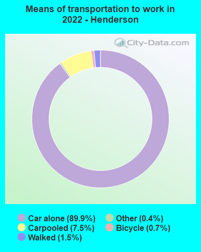
Workers who live and work in this city: 1,272 (55.9%)
Area code: 731

Henderson, Tennessee accommodation & food services, waste management - Economy and Business Data
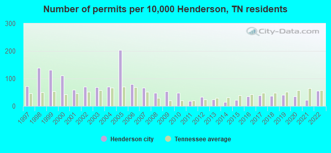
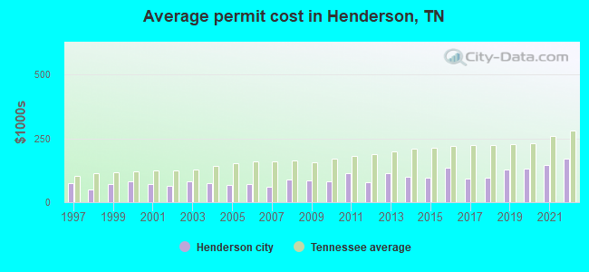
Single-family new house construction building permits:
- 2022: 32 buildings, average cost: $170,100
- 2021: 13 buildings, average cost: $144,400
- 2020: 20 buildings, average cost: $129,500
- 2019: 23 buildings, average cost: $125,600
- 2018: 21 buildings, average cost: $95,900
- 2017: 22 buildings, average cost: $91,300
- 2016: 20 buildings, average cost: $135,000
- 2015: 13 buildings, average cost: $96,600
- 2014: 8 buildings, average cost: $97,500
- 2013: 14 buildings, average cost: $113,000
- 2012: 19 buildings, average cost: $78,600
- 2011: 11 buildings, average cost: $113,600
- 2010: 27 buildings, average cost: $83,000
- 2009: 30 buildings, average cost: $84,900
- 2008: 27 buildings, average cost: $87,700
- 2007: 38 buildings, average cost: $62,000
- 2006: 45 buildings, average cost: $70,600
- 2005: 115 buildings, average cost: $69,400
- 2004: 40 buildings, average cost: $74,700
- 2003: 39 buildings, average cost: $81,500
- 2002: 40 buildings, average cost: $65,000
- 2001: 34 buildings, average cost: $70,100
- 2000: 63 buildings, average cost: $80,000
- 1999: 75 buildings, average cost: $72,400
- 1998: 78 buildings, average cost: $51,300
- 1997: 41 buildings, average cost: $75,800
| Here: | 2.9% |
| Tennessee: | 3.0% |
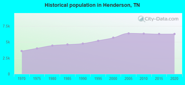
Population change in the 1990s: +555 (+10.9%).
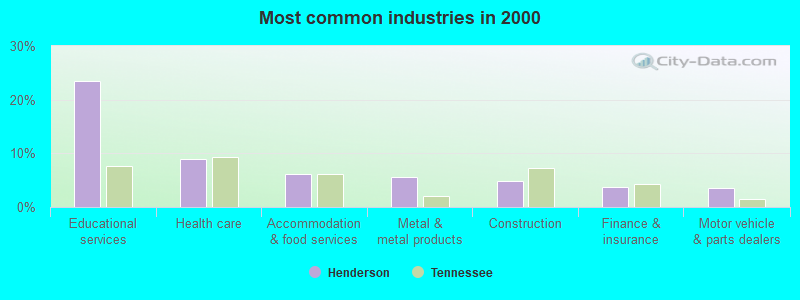
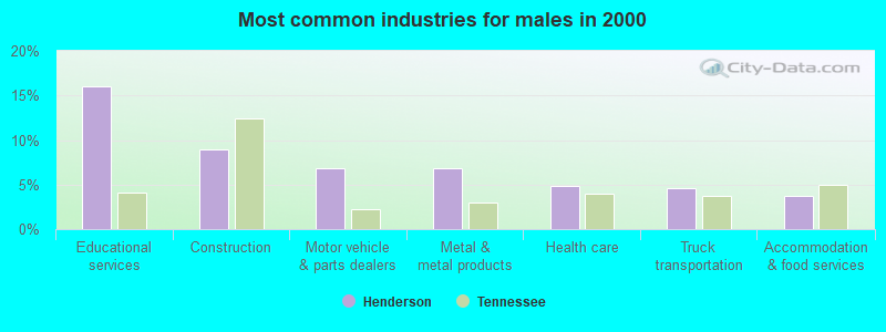
- Educational services (23.4%)
- Health care (8.9%)
- Accommodation & food services (6.2%)
- Metal & metal products (5.6%)
- Construction (4.9%)
- Finance & insurance (3.8%)
- Motor vehicle & parts dealers (3.6%)
- Educational services (16.1%)
- Construction (9.0%)
- Motor vehicle & parts dealers (6.9%)
- Metal & metal products (6.8%)
- Health care (4.9%)
- Truck transportation (4.6%)
- Accommodation & food services (3.8%)
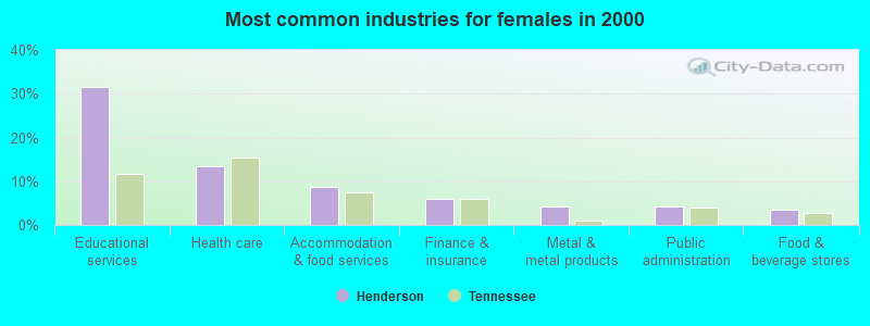
- Educational services (31.4%)
- Health care (13.4%)
- Accommodation & food services (8.8%)
- Finance & insurance (6.0%)
- Metal & metal products (4.3%)
- Public administration (4.1%)
- Food & beverage stores (3.5%)
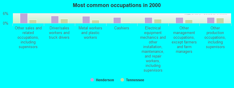
- Other sales and related occupations, including supervisors (6.0%)
- Driver/sales workers and truck drivers (4.6%)
- Metal workers and plastic workers (4.3%)
- Cashiers (3.7%)
- Electrical equipment mechanics and other installation, maintenance, and repair workers, including supervisors (3.7%)
- Other management occupations, except farmers and farm managers (3.6%)
- Other production occupations, including supervisors (3.6%)
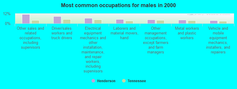
- Other sales and related occupations, including supervisors (11.1%)
- Driver/sales workers and truck drivers (8.8%)
- Electrical equipment mechanics and other installation, maintenance, and repair workers, including supervisors (6.7%)
- Laborers and material movers, hand (5.0%)
- Other management occupations, except farmers and farm managers (4.8%)
- Metal workers and plastic workers (4.5%)
- Vehicle and mobile equipment mechanics, installers, and repairers (3.7%)
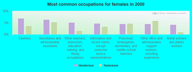
- Cashiers (6.9%)
- Secretaries and administrative assistants (6.4%)
- Other teachers, instructors, education, training, and library occupations (5.1%)
- Information and record clerks, except customer service representatives (4.8%)
- Preschool, kindergarten, elementary, and middle school teachers (4.6%)
- Other office and administrative support workers, including supervisors (4.5%)
- Metal workers and plastic workers (4.2%)
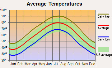
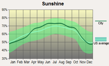
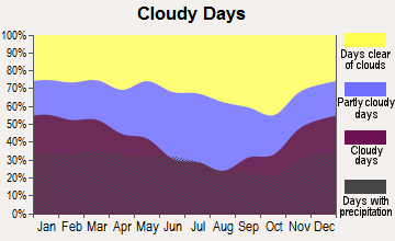
Average climate in Henderson, Tennessee
Based on data reported by over 4,000 weather stations
|
|


(lower is better)
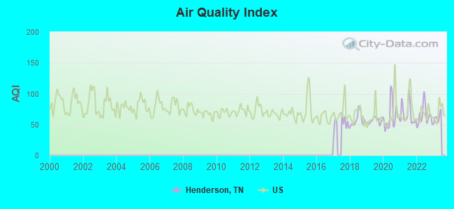
Air Quality Index (AQI) level in 2022 was 64.2. This is about average.
| City: | 64.2 |
| U.S.: | 72.6 |
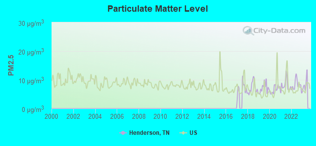
Particulate Matter (PM2.5) [µg/m3] level in 2022 was 8.18. This is about average. Closest monitor was 15.0 miles away from the city center.
| City: | 8.18 |
| U.S.: | 8.11 |
Tornado activity:
Henderson-area historical tornado activity is slightly above Tennessee state average. It is 91% greater than the overall U.S. average.
On 1/17/1999, a category F4 (max. wind speeds 207-260 mph) tornado 13.1 miles away from the Henderson city center killed 6 people and injured 106 people and caused $10 million in damages.
On 4/3/1956, a category F4 tornado 13.6 miles away from the city center killed 3 people and injured 60 people and caused between $500,000 and $5,000,000 in damages.
Earthquake activity:
Henderson-area historical earthquake activity is significantly above Tennessee state average. It is 307% greater than the overall U.S. average.On 3/25/1976 at 00:41:20, a magnitude 5.0 (4.9 MB, 5.0 LG, Class: Moderate, Intensity: VI - VII) earthquake occurred 95.6 miles away from the city center
On 5/4/1991 at 01:18:54, a magnitude 5.0 (4.4 MB, 4.6 LG, 5.0 LG, Depth: 3.1 mi) earthquake occurred 101.8 miles away from the city center
On 9/26/1990 at 13:18:51, a magnitude 5.0 (4.7 MB, 4.8 LG, 5.0 LG, Depth: 7.7 mi) earthquake occurred 129.2 miles away from the city center
On 4/18/2008 at 09:36:59, a magnitude 5.4 (5.1 MB, 4.8 MS, 5.4 MW, 5.2 MW) earthquake occurred 212.3 miles away from Henderson center
On 4/27/1989 at 16:47:49, a magnitude 4.7 (4.6 MB, 4.7 LG, 4.3 LG, Class: Light, Intensity: IV - V) earthquake occurred 74.1 miles away from Henderson center
On 4/18/2008 at 09:36:59, a magnitude 5.2 (5.2 MW, Depth: 8.9 mi) earthquake occurred 212.3 miles away from Henderson center
Magnitude types: regional Lg-wave magnitude (LG), body-wave magnitude (MB), surface-wave magnitude (MS), moment magnitude (MW)
Natural disasters:
The number of natural disasters in Chester County (12) is smaller than the US average (15).Major Disasters (Presidential) Declared: 10
Emergencies Declared: 1
Causes of natural disasters: Floods: 9, Storms: 9, Tornadoes: 5, Winds: 3, Flash Flood: 1, Hurricane: 1, Ice Storm: 1, Winter Storm: 1, Other: 1 (Note: some incidents may be assigned to more than one category).
Hospitals and medical centers in Henderson:
Other hospitals and medical centers near Henderson:
- DAVITA SOUTH JACKSON (Dialysis Facility, about 14 miles away; JACKSON, TN)
- LAURELWOOD HEALTHCARE CENTER (Nursing Home, about 15 miles away; JACKSON, TN)
- (CLOSED) CLOVERDALE TRACE HC AND REHAB (Nursing Home, about 15 miles away; JACKSON, TN)
- JACKSON MANOR (Nursing Home, about 15 miles away; JACKSON, TN)
- MISSION CONVALESCENT HOME (Nursing Home, about 16 miles away; JACKSON, TN)
- COUNTRY HOSPICE (Hospital, about 16 miles away; JACKSON, TN)
- PROCARE SUPPORT SERVICES INC (Hospital, about 16 miles away; JACKSON, TN)
College/University in Henderson:
Colleges/universities with over 2000 students nearest to Henderson:
- Jackson State Community College (about 17 miles; Jackson, TN; Full-time enrollment: 2,958)
- Union University (about 21 miles; Jackson, TN; FT enrollment: 4,051)
- Bethel University (about 49 miles; McKenzie, TN; FT enrollment: 5,878)
- Northeast Mississippi Community College (about 54 miles; Booneville, MS; FT enrollment: 3,024)
- Dyersburg State Community College (about 60 miles; Dyersburg, TN; FT enrollment: 2,211)
- The University of Tennessee-Martin (about 64 miles; Martin, TN; FT enrollment: 7,013)
- University of North Alabama (about 71 miles; Florence, AL; FT enrollment: 5,886)
Public high school in Henderson:
- CHESTER COUNTY HIGH SCHOOL (Students: 780, Location: 552 EAST MAIN ST, Grades: 9-12)
Public elementary/middle schools in Henderson:
- CHESTER COUNTY MIDDLE SCHOOL (Students: 637, Location: 634 EAST MAIN ST, Grades: 4-5)
- CHESTER COUNTY JUNIOR HIGH SCHOOL (Students: 440, Location: 930 EAST MAIN ST, Grades: 6-8)
- EAST CHESTER ELEMENTARY SCHOOL (Students: 419, Location: 708 EAST MAIN ST, Grades: PK-3)
- W CHESTER ELEMENTARY SCHOOL (Students: 316, Location: 1243 WEST MAIN ST, Grades: KG-3)
User-submitted facts and corrections:
- Love and Truth Church located on the 45 bypass is an awesome spirit-filled home church that has changed my life.If you're looking for God and can't find him,come here.Just give it a chance.I did and it was the best thing that I have done in a long time.They have a wonderful praise band and a great place for the kids and teens.My daughter is in fusion and they rock the house with praise for the King of Kings and the Lord of Lords.In God's Grace.
Points of interest:
Notable locations in Henderson: Henderson Industrial Park (A), Chester County Fire Department Headquarters (B), Henderson Fire Department Station 2 (C), Henderson City Hall (D), Chester County Nursing Home (E), Chester County Courthouse (F), Henderson Fire Department (G). Display/hide their locations on the map
Churches in Henderson include: Cool Springs Baptist Church (A), First Pentecostal Church (B), First United Methodist Church (C), Henderson Church of Christ (D), Sanford Hill Baptist Church (E), Henderson First Baptist Church (F). Display/hide their locations on the map
Cemetery: Henderson Cemetery (1). Display/hide its location on the map
Parks in Henderson include: Memorial Park (1), Dixie Youth Park (2). Display/hide their locations on the map
Hotels: College Inn (278 North Church Avenue Ofc), College Inn Motel (278 North Church Avenue Ofc), Americana Inn (550 Sanford Street).
Courts: Chester County - County Court Clerk (133 East Main Street), Chester County - General Sessions Circuit Court Clerk- Circuit Court C (133 East Main Street).
Birthplace of: Dorsey B. Hardeman - Texas politician, Jack Dalton (baseball) - Baseball player, Eddy Arnold - musician.
Drinking water stations with addresses in Henderson and their reported violations in the past:
HENDERSON WATER DEPT. (Population served: 8,752, Groundwater):Past monitoring violations:CHICKASAW ST PARK LAKE LAJOIE GROUP CAMP (Population served: 120, Groundwater):
- Monitoring and Reporting (DBP) - Between OCT-2012 and DEC-2012, Contaminant: Chlorine. Follow-up actions: St Public Notif requested (FEB-13-2013), St Violation/Reminder Notice (FEB-13-2013)
Past monitoring violations:
- 3 routine major monitoring violations
| This city: | 2.5 people |
| Tennessee: | 2.5 people |
| This city: | 66.5% |
| Whole state: | 67.3% |
| This city: | 5.3% |
| Whole state: | 5.8% |
Likely homosexual households (counted as self-reported same-sex unmarried-partner households)
- Lesbian couples: 0.2% of all households
- Gay men: 0.1% of all households
People in group quarters in Henderson in 2010:
- 1,087 people in college/university student housing
- 127 people in nursing facilities/skilled-nursing facilities
- 23 people in local jails and other municipal confinement facilities
People in group quarters in Henderson in 2000:
- 935 people in college dormitories (includes college quarters off campus)
- 136 people in nursing homes
- 25 people in local jails and other confinement facilities (including police lockups)
Banks with branches in Henderson (2011 data):
- Clayton Bank and Trust: Old Main Office Branch, East Branch, North Henderson Drive-In Branch. Info updated 2011/11/16: Bank assets: $628.8 mil, Deposits: $500.3 mil, headquarters in Knoxville, TN, positive income, Commercial Lending Specialization, 14 total offices, Holding Company: Clayton Bancorp, Inc
- Chester County Bank: at Main And Franklin Streets, East Main Branch, Henderson Branch. Info updated 2006/11/03: Bank assets: $62.6 mil, Deposits: $54.8 mil, local headquarters, positive income, 4 total offices, Holding Company: Chester County Bancshares, Inc.
- The Peoples Bank: Henderson Branch at 573 East Main Street, branch established on 1999/12/24. Info updated 2010/06/02: Bank assets: $74.8 mil, Deposits: $68.0 mil, headquarters in Sardis, TN, positive income, 4 total offices, Holding Company: 1st Jackson Bancshares, Inc.
- Regions Bank: Henderson Branch at 611 North Church Street, branch established on 1998/05/18. Info updated 2011/02/24: Bank assets: $123,368.2 mil, Deposits: $98,301.3 mil, headquarters in Birmingham, AL, positive income, Commercial Lending Specialization, 1778 total offices, Holding Company: Regions Financial Corporation
- Decatur County Bank: West Tennessee Bank, A Division Of at 1007 U. S. Highway 45 North, branch established on 2010/07/19. Info updated 2006/11/03: Bank assets: $90.2 mil, Deposits: $77.5 mil, headquarters in Decaturville, TN, negative income in the last year, Commercial Lending Specialization, 3 total offices, Holding Company: Decatur Bancshares, Inc
- First State Bank: First State Mortgage - Henderson Lpo at 102 South Cason, branch established on 2006/02/21. Info updated 2006/11/03: Bank assets: $1,646.2 mil, Deposits: $1,393.0 mil, headquarters in Union City, TN, positive income, Commercial Lending Specialization, 32 total offices, Holding Company: Community First Bancshares, Inc.
For population 15 years and over in Henderson:
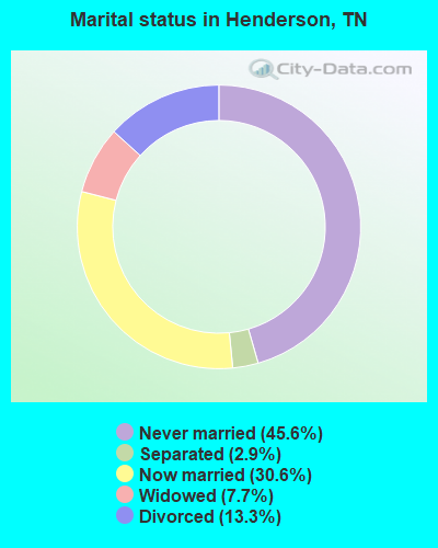
- Never married: 45.6%
- Now married: 30.6%
- Separated: 2.9%
- Widowed: 7.7%
- Divorced: 13.3%
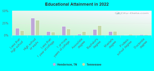
For population 25 years and over in Henderson:
- High school or higher: 84.4%
- Bachelor's degree or higher: 20.6%
- Graduate or professional degree: 9.4%
- Unemployed: 10.4%
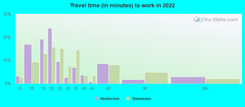
- Mean travel time to work (commute): 19.9 minutes
| Here: | 10.1 |
| Tennessee average: | 11.4 |
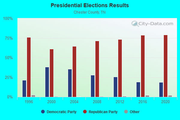
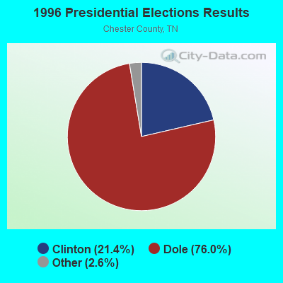
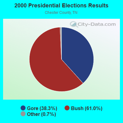
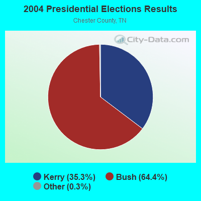
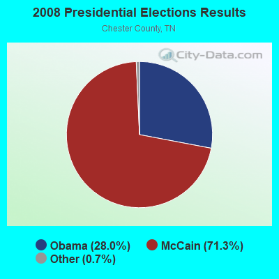
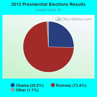
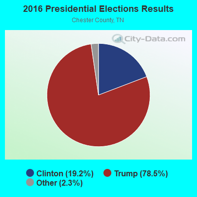
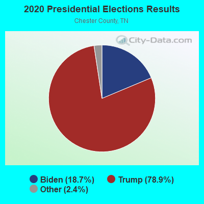
Graphs represent county-level data. Detailed 2008 Election Results
Religion statistics for Henderson, TN (based on Chester County data)
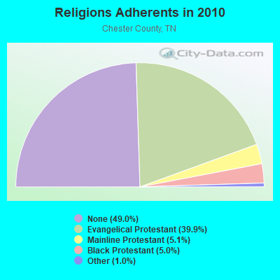
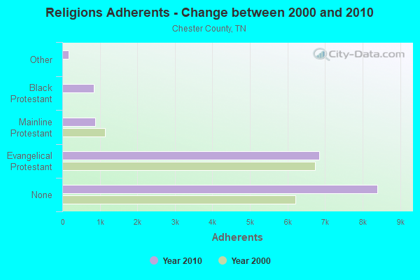
| Religion | Adherents | Congregations |
|---|---|---|
| Evangelical Protestant | 6,837 | 30 |
| Mainline Protestant | 869 | 9 |
| Black Protestant | 848 | 7 |
| Other | 176 | 3 |
| None | 8,401 | - |
Food Environment Statistics:
| Chester County: | 3.11 / 10,000 pop. |
| State: | 1.99 / 10,000 pop. |
| This county: | 4.97 / 10,000 pop. |
| Tennessee: | 5.16 / 10,000 pop. |
| Chester County: | 2.49 / 10,000 pop. |
| Tennessee: | 6.56 / 10,000 pop. |
| Chester County: | 13.1% |
| Tennessee: | 11.4% |
| Here: | 30.9% |
| State: | 30.2% |
| Here: | 11.3% |
| Tennessee: | 13.5% |
Health and Nutrition:
| Here: | 46.4% |
| Tennessee: | 49.3% |
| Henderson: | 42.8% |
| Tennessee: | 46.1% |
| This city: | 29.0 |
| State: | 28.8 |
| Henderson: | 24.6% |
| Tennessee: | 21.0% |
| This city: | 16.3% |
| Tennessee: | 10.5% |
| Henderson: | 6.9 |
| Tennessee: | 6.8 |
| Henderson: | 34.8% |
| Tennessee: | 33.9% |
| Here: | 52.1% |
| Tennessee: | 55.9% |
| Henderson: | 80.5% |
| State: | 79.1% |
More about Health and Nutrition of Henderson, TN Residents
| Local government employment and payroll (March 2022) | |||||
| Function | Full-time employees | Monthly full-time payroll | Average yearly full-time wage | Part-time employees | Monthly part-time payroll |
|---|---|---|---|---|---|
| Police Protection - Officers | 16 | $69,832 | $52,374 | 0 | $0 |
| Solid Waste Management | 11 | $38,588 | $42,096 | 0 | $0 |
| Financial Administration | 8 | $29,534 | $44,301 | 0 | $0 |
| Water Supply | 7 | $27,160 | $46,560 | 0 | $0 |
| Gas Supply | 5 | $18,875 | $45,300 | 0 | $0 |
| Firefighters | 4 | $18,246 | $54,738 | 1 | $299 |
| Other and Unallocable | 4 | $15,082 | $45,246 | 1 | $2,555 |
| Sewerage | 3 | $9,285 | $37,140 | 0 | $0 |
| Other Government Administration | 1 | $2,942 | $35,304 | 0 | $0 |
| Police - Other | 0 | $0 | 1 | $1,278 | |
| Parks and Recreation | 0 | $0 | 2 | $3,891 | |
| Totals for Government | 59 | $229,543 | $46,687 | 5 | $8,023 |
Henderson government finances - Expenditure in 2017 (per resident):
- Construction - Water Utilities: $373,000 ($58.07)
Gas Utilities: $330,000 ($51.38)
Sewerage: $139,000 ($21.64)
- Current Operations - Gas Utilities: $1,673,000 ($260.47)
Regular Highways: $950,000 ($147.91)
Water Utilities: $818,000 ($127.35)
Police Protection: $617,000 ($96.06)
Sewerage: $349,000 ($54.34)
Solid Waste Management: $221,000 ($34.41)
Local Fire Protection: $184,000 ($28.65)
General Public Buildings: $105,000 ($16.35)
Financial Administration: $102,000 ($15.88)
General - Other: $55,000 ($8.56)
Protective Inspection and Regulation - Other: $43,000 ($6.69)
Health - Other: $38,000 ($5.92)
Parks and Recreation: $25,000 ($3.89)
Public Welfare - Other: $15,000 ($2.34)
Miscellaneous Commercial Activities - Other: $14,000 ($2.18)
Central Staff Services: $9,000 ($1.40)
- Gas Utilities - Interest on Debt: $34,000 ($5.29)
- General - Interest on Debt: $190,000 ($29.58)
- Other Capital Outlay - General - Other: $364,000 ($56.67)
Parks and Recreation: $221,000 ($34.41)
Police Protection: $33,000 ($5.14)
Local Fire Protection: $20,000 ($3.11)
Regular Highways: $16,000 ($2.49)
- Total Salaries and Wages: $1,562,000 ($243.19)
- Water Utilities - Interest on Debt: $48,000 ($7.47)
Henderson government finances - Revenue in 2017 (per resident):
- Charges - Sewerage: $654,000 ($101.82)
Solid Waste Management: $483,000 ($75.20)
Other: $410,000 ($63.83)
- Local Intergovernmental - General Local Government Support: $270,000 ($42.04)
- Miscellaneous - Rents: $260,000 ($40.48)
Fines and Forfeits: $185,000 ($28.80)
Interest Earnings: $82,000 ($12.77)
Sale of Property: $26,000 ($4.05)
General Revenue - Other: $3,000 ($0.47)
Donations From Private Sources: $1,000 ($0.16)
- Revenue - Gas Utilities: $2,076,000 ($323.21)
Water Utilities: $1,164,000 ($181.22)
- State Intergovernmental - General Local Government Support: $541,000 ($84.23)
Other: $390,000 ($60.72)
Highways: $195,000 ($30.36)
- Tax - Property: $1,377,000 ($214.39)
Alcoholic Beverage Sales: $207,000 ($32.23)
Occupation and Business License - Other: $127,000 ($19.77)
Public Utility License: $64,000 ($9.96)
Other License: $39,000 ($6.07)
Other Selective Sales: $27,000 ($4.20)
Henderson government finances - Debt in 2017 (per resident):
- Long Term Debt - Beginning Outstanding - Unspecified Public Purpose: $6,797,000 ($1058.23)
Outstanding Unspecified Public Purpose: $5,801,000 ($903.16)
Retired Unspecified Public Purpose: $996,000 ($155.07)
Henderson government finances - Cash and Securities in 2017 (per resident):
- Other Funds - Cash and Securities: $3,010,000 ($468.63)
- Sinking Funds - Cash and Securities: $595,000 ($92.64)
| Businesses in Henderson, TN | ||||
| Name | Count | Name | Count | |
|---|---|---|---|---|
| AutoZone | 1 | McDonald's | 1 | |
| Baskin-Robbins | 1 | Pizza Hut | 1 | |
| Burger King | 1 | RadioShack | 1 | |
| Chevrolet | 1 | SONIC Drive-In | 1 | |
| Domino's Pizza | 1 | Sears | 1 | |
| FedEx | 1 | Subway | 1 | |
| Ford | 1 | Taco Bell | 1 | |
| H&R Block | 1 | U-Haul | 1 | |
| La-Z-Boy | 1 | UPS | 1 | |
Strongest AM radio stations in Henderson:
- WCRV (640 AM; 50 kW; COLLIERVILLE, TN; Owner: BOTT BROADCASTING COMPANY/TENNESSEE)
- WTJS (1390 AM; 5 kW; JACKSON, TN; Owner: CAPSTAR TX LIMITED PARTNERSHIP)
- WDXI (1310 AM; 5 kW; JACKSON, TN; Owner: LIBERTY RADIO II, INC.)
- WGSF (1030 AM; 50 kW; MEMPHIS, TN; Owner: FLINN BROADCASTING CORPORATION)
- WDIA (1070 AM; 50 kW; MEMPHIS, TN; Owner: CLEAR CHANNEL BROADCASTING LICENSES, INC.)
- WMQM (1600 AM; 50 kW; LAKELAND, TN; Owner: WMQM, INC.)
- WSM (650 AM; 50 kW; NASHVILLE, TN; Owner: GAYLORD ENTERTAINMENT COMPANY)
- WCPC (940 AM; 50 kW; HOUSTON, MS; Owner: WCPC BROADCASTING CO., INC.)
- WKDA (1200 AM; 50 kW; NASHVILLE, TN; Owner: RADIO NASHVILLE, INC.)
- WNQM (1300 AM; 50 kW; NASHVILLE, TN; Owner: WNQM. INC.)
- WAMB (1160 AM; 50 kW; DONELSON, TN; Owner: GREAT SOUTHERN BROADCASTING COMPANY, INC.)
- WJAK (1460 AM; 1 kW; JACKSON, TN; Owner: JAMES E. WOLFE, JR.)
- WDTM (1150 AM; daytime; 1 kW; SELMER, TN; Owner: RADIO STATION WDTM, INC)
Strongest FM radio stations in Henderson:
- WHHM-FM (107.7 FM; HENDERSON, TN; Owner: THOMAS RADIO, LLC)
- WFHC (91.5 FM; HENDERSON, TN; Owner: FREED-HARDEMAN UNIVERSITY)
- WFKX (95.7 FM; HENDERSON, TN; Owner: THOMAS RADIO, LLC)
- WMXX-FM (103.1 FM; JACKSON, TN; Owner: GERALD W. HUNT)
- WTNV (104.1 FM; JACKSON, TN; Owner: CAPSTAR TX LIMITED PARTNERSHIP)
- WKNP (90.1 FM; JACKSON, TN; Owner: MID-SOUTH PUBLIC COMMUNICTNS FOUNDTN)
- WIGH (88.7 FM; LEXINGTON, TN; Owner: AMERICAN FAMILY ASSOCIATION)
- WYNU (92.3 FM; MILAN, TN; Owner: CAPSTAR TX LIMITED PARTNERSHIP)
- WNWS-FM (101.5 FM; JACKSON, TN; Owner: RADIOCORP OF JACKSON, INC.)
- WWYN (106.9 FM; MCKENZIE, TN; Owner: RAINBOW MEDIA, INC.)
- WXOQ (105.5 FM; SELMER, TN; Owner: GERALD W. HUNT)
- WSIB (93.9 FM; SELMER, TN; Owner: WDTM INC)
- WOJG (94.7 FM; BOLIVAR, TN; Owner: JOHNNY W. SHAW & OPAL J. SHAW)
- WMOD (96.7 FM; BOLIVAR, TN; Owner: WMOD, INC.)
- WYDL (100.7 FM; MIDDLETON, TN; Owner: FLINN BROADCASTING CORPORATION)
TV broadcast stations around Henderson:
- WBBJ-TV (Channel 7; JACKSON, TN; Owner: TENNESSEE BROADCASTING PARTNERS)
- W25BY (Channel 25; JACKSON, TN; Owner: MS COMMUNICATIONS, LLC)
- W38BY (Channel 38; JACKSON, TN; Owner: MS COMMUNICATIONS, LLC)
- W54BU (Channel 54; JACKSON, TN; Owner: MS COMMUNICATIONS, LLC)
- W22BR (Channel 22; JACKSON, TN; Owner: MS COMMUNICATIONS, LLC)
- W52CZ (Channel 52; JACKSON, TN; Owner: MS COMMUNICATIONS, LLC)
- W64BZ (Channel 64; JACKSON, TN; Owner: MS COMMUNICATIONS, LLC)
- WJTE-LP (Channel 19; JACKSON, TN; Owner: TIGER EYE BROADCASTING CORPORATION)
- W26CJ (Channel 26; JACKSON, TN; Owner: MS COMMUNICATIONS, LLC)
- WLJT (Channel 11; LEXINGTON, TN; Owner: WEST TENNESSEE PUBLIC TV COUNCIL, INC)
- W35AH (Channel 35; JACKSON, TN; Owner: TRINITY BROADCASTING NETWORK)
- WJKT (Channel 16; JACKSON, TN; Owner: CLEAR CHANNEL BROADCASTING LICENSES, INC.)
- W46CG (Channel 46; JACKSON, TN; Owner: MS COMMUNICATIONS, LLC)
- W34BU (Channel 34; ACTON, TN; Owner: MS COMMUNICATIONS, LLC)
- W06AW (Channel 6; SELMER, TN; Owner: WDTM, INC.)
- W62CK (Channel 62; ACTON, TN; Owner: MS COMMUNICATIONS, LLC)
- National Bridge Inventory (NBI) Statistics
- 69Number of bridges
- 965ft / 294mTotal length
- $22,834,000Total costs
- 299,263Total average daily traffic
- 22,313Total average daily truck traffic
- New bridges - historical statistics
- 21920-1929
- 81930-1939
- 11950-1959
- 51960-1969
- 111970-1979
- 141980-1989
- 41990-1999
- 232000-2009
- 12010-2019
FCC Registered Antenna Towers: 51 (See the full list of FCC Registered Antenna Towers)
FCC Registered Commercial Land Mobile Towers: 2 (See the full list of FCC Registered Commercial Land Mobile Towers in Henderson, TN)
FCC Registered Broadcast Land Mobile Towers: 14 (See the full list of FCC Registered Broadcast Land Mobile Towers)
FCC Registered Microwave Towers: 13 (See the full list of FCC Registered Microwave Towers in this town)
FCC Registered Amateur Radio Licenses: 91 (See the full list of FCC Registered Amateur Radio Licenses in Henderson)
FAA Registered Aircraft: 15 (See the full list of FAA Registered Aircraft in Henderson)
2002 - 2018 National Fire Incident Reporting System (NFIRS) incidents
- Fire incident types reported to NFIRS in Henderson, TN
- 44941.1%Outside Fires
- 43239.6%Structure Fires
- 17916.4%Mobile Property/Vehicle Fires
- 322.9%Other
 Based on the data from the years 2002 - 2018 the average number of fire incidents per year is 64. The highest number of reported fire incidents - 96 took place in 2010, and the least - 25 in 2018. The data has a declining trend.
 When looking into fire subcategories, the most reports belonged to: Outside Fires (41.1%), and Structure Fires (39.6%).
| Most common first names in Henderson, TN among deceased individuals | ||
| Name | Count | Lived (average) |
|---|---|---|
| James | 94 | 73.5 years |
| Mary | 92 | 80.9 years |
| John | 87 | 76.7 years |
| William | 86 | 72.5 years |
| Robert | 67 | 76.6 years |
| Willie | 41 | 77.1 years |
| Joe | 31 | 77.0 years |
| Charles | 23 | 68.7 years |
| Thomas | 23 | 76.9 years |
| Ruth | 22 | 82.1 years |
| Most common last names in Henderson, TN among deceased individuals | ||
| Last name | Count | Lived (average) |
|---|---|---|
| Smith | 96 | 76.0 years |
| Johnson | 50 | 76.6 years |
| Jones | 46 | 73.2 years |
| Davis | 40 | 76.0 years |
| Ross | 34 | 76.2 years |
| Thomas | 26 | 77.1 years |
| Morris | 26 | 77.3 years |
| Moore | 25 | 75.0 years |
| Plunk | 25 | 74.2 years |
| Young | 23 | 76.8 years |
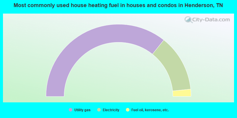
- 71.4%Utility gas
- 25.3%Electricity
- 3.2%Fuel oil, kerosene, etc.
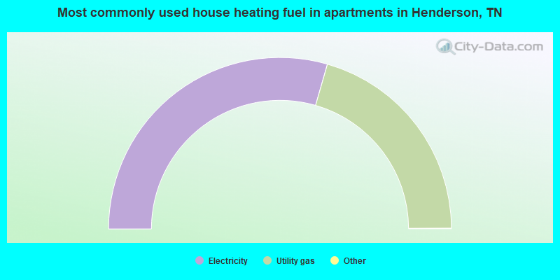
- 59.0%Electricity
- 41.0%Utility gas
Henderson compared to Tennessee state average:
- Median house value below state average.
- Median age significantly below state average.
- Foreign-born population percentage below state average.
- Length of stay since moving in significantly above state average.
- Number of college students above state average.
Henderson on our top lists:
- #55 on the list of "Top 101 cities with the most people taking a motorcycle to work (population 5,000+)"
- #91 on the list of "Top 100 cities with highest percentage of college students (pop. 5,000+)"

|
|
Total of 9 patent applications in 2008-2024.