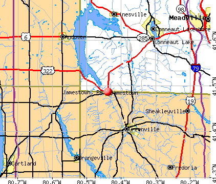
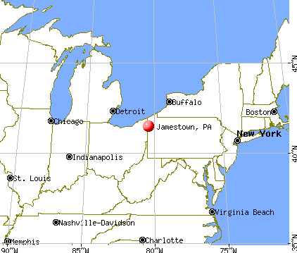
Jamestown, Pennsylvania
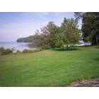
Jamestown: Pymatuning Lake

Jamestown: Wild Phlox that grow everywhere in Pymatuning
Jamestown: Pymatuning Lake
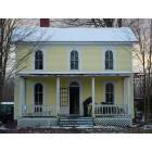
Jamestown: 509 Liberty Street - In process restoration

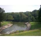
Jamestown: Pymatuning State Park

Jamestown: Pymatuning State Park
- add
your
Submit your own pictures of this borough and show them to the world
- OSM Map
- General Map
- Google Map
- MSN Map
Population change since 2000: -9.4%
 |
| Males: 264 | |
| Females: 312 |
| Median resident age: | 42.6 years |
| Pennsylvania median age: | 40.9 years |
Zip codes: 16134.
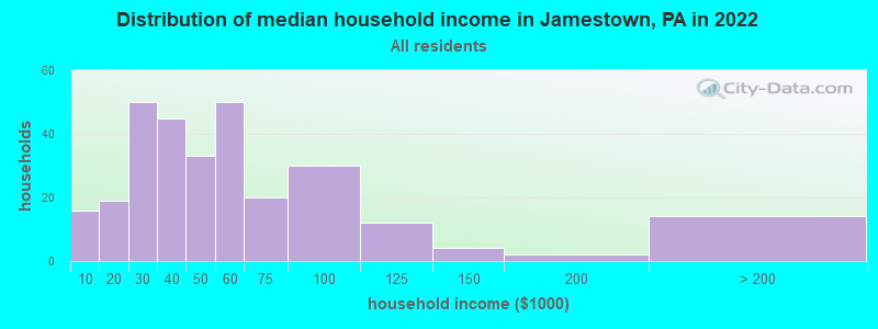
| Jamestown: | $41,189 |
| PA: | $71,798 |
Estimated per capita income in 2022: $26,588 (it was $15,199 in 2000)
Jamestown borough income, earnings, and wages data
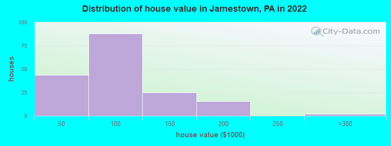
Estimated median house or condo value in 2022: $90,119 (it was $63,300 in 2000)
| Jamestown: | $90,119 |
| PA: | $245,500 |
Mean prices in 2022: all housing units: $83,771; detached houses: $93,665; mobile homes: $33,557
Median gross rent in 2022: $809.
Detailed information about poverty and poor residents in Jamestown, PA
Compare current foreclosures near Jamestown, PA:
| Photo | Address | Area | Beds / Baths | Price | Details |
|---|---|---|---|---|---|

|
#1
N 2nd St
Jamestown, PA 16134
|
1,800 sq. feet
|
2 baths 3 beds |
$189,900
|
show details |

|
#2
Shenango Dr
Jamestown, PA 16134
|
- sq. feet
|
- baths - beds |
show details | |

|
#3
Westford Rd
Jamestown, PA 16134
|
- sq. feet
|
- baths - beds |
show details | |

|
#4
Revere Ln
Jamestown, PA 16134
|
- sq. feet
|
- baths - beds |
show details | |

|
#5
Algoma St
Jamestown, PA 16134
|
- sq. feet
|
- baths - beds |
show details | |

|
#6
Oak St
Sharpsville, PA 16150
|
1,333 sq. feet
|
2 baths 3 beds |
$314,900
|
show details |

|
#7
S 1st St
Jamestown, PA 16134
|
- sq. feet
|
- baths - beds |
show details | |

|
#8
Plymouth Ln
Jamestown, PA 16134
|
- sq. feet
|
- baths - beds |
show details | |

|
#9
Maple Rd
Greenville, PA 16125
|
1,340 sq. feet
|
2 baths 3 beds |
show details | |

|
#10
N Main St
Greenville, PA 16125
|
- sq. feet
|
1 baths 2 beds |
show details |
| Photo | Address | Area | Beds / Baths | Price | Details |
|---|---|---|---|---|---|

|
#11
Everett Hull Rd
Fowler, OH 44418
|
1,920 sq. feet
|
2 baths 3 beds |
show details | |

|
#12
W Lake Rd
Transfer, PA 16154
|
1,900 sq. feet
|
1 baths 3 beds |
show details | |

|
#13
High St
Conneaut Lake, PA 16316
|
1,350 sq. feet
|
1 baths 3 beds |
show details | |

|
#14
Bushnell Campbell Rd
Kinsman, OH 44428
|
- sq. feet
|
2 baths 4 beds |
show details | |

|
#15
S 18th St
Sharpsville, PA 16150
|
- sq. feet
|
1 baths 2 beds |
show details | |

|
#16
Grant St
Fredonia, PA 16124
|
- sq. feet
|
1 baths 3 beds |
show details | |

|
#17
Custer Orangeville Rd
Masury, OH 44438
|
1,876 sq. feet
|
2 baths 3 beds |
show details | |

|
#18
State Route 7
Burghill, OH 44404
|
1,772 sq. feet
|
1 baths 4 beds |
show details | |

|
#19
State Route 7
Williamsfield, OH 44093
|
1,906 sq. feet
|
1 baths 3 beds |
show details | |

|
#20
Youngstown Kingsville Rd
Farmdale, OH 44417
|
1,296 sq. feet
|
1 baths 3 beds |
show details |
| Photo | Address | Area | Beds / Baths | Price | Details |
|---|---|---|---|---|---|

|
#21
Creek Rd
Andover, OH 44003
|
1,116 sq. feet
|
1 baths 3 beds |
show details | |

|
#22
State Route 193
Andover, OH 44003
|
960 sq. feet
|
1 baths 3 beds |
show details | |

|
#23
Drake Stateline Rd NE
Burghill, OH 44404
|
1,344 sq. feet
|
2 baths 3 beds |
show details | |

|
#24
Adamsville Rd
Cochranton, PA 16314
|
- sq. feet
|
2 baths 2 beds |
show details | |

|
#25
Ridge Rd
Cortland, OH 44410
|
2,052 sq. feet
|
2 baths 3 beds |
show details | |

|
#26
Stoddard Hayes Rd
Farmdale, OH 44417
|
1,832 sq. feet
|
2 baths 3 beds |
show details | |

|
#27
Leon Rd
Andover, OH 44003
|
1,140 sq. feet
|
1 baths 3 beds |
show details | |

|
#28
Everett Hull Rd
Cortland, OH 44410
|
1,542 sq. feet
|
2 baths 3 beds |
show details | |

|
#29
Arlington Dr
Greenville, PA 16125
|
- sq. feet
|
1 baths 3 beds |
show details | |

|
#30
Leech Rd
Greenville, PA 16125
|
- sq. feet
|
- baths - beds |
show details |
| Photo | Address | Area | Beds / Baths | Price | Details |
|---|---|---|---|---|---|

|
#31
Us Highway 6
Linesville, PA 16424
|
- sq. feet
|
- baths - beds |
show details | |

|
#32
Gehrton Rd
Conneaut Lake, PA 16316
|
- sq. feet
|
- baths - beds |
show details | |

|
#33
Ontario St
Meadville, PA 16335
|
- sq. feet
|
- baths - beds |
show details | |

|
#34
N Hermitage Rd Lot 80
Transfer, PA 16154
|
- sq. feet
|
- baths - beds |
show details | |

|
#35
19th St
Greenville, PA 16125
|
- sq. feet
|
- baths - beds |
show details | |

|
#36
Bean Rd Lot 101
Hadley, PA 16130
|
- sq. feet
|
- baths - beds |
show details | |

|
#37
Mohawk Rd
Conneaut Lake, PA 16316
|
- sq. feet
|
- baths - beds |
show details | |

|
#38
S Mercer St
Linesville, PA 16424
|
- sq. feet
|
- baths - beds |
show details | |

|
#39
Schumaker St
Conneaut Lake, PA 16316
|
- sq. feet
|
- baths - beds |
show details | |

|
#40
Dicksonburg Rd
Conneautville, PA 16406
|
- sq. feet
|
- baths - beds |
show details |
| Photo | Address | Area | Beds / Baths | Price | Details |
|---|---|---|---|---|---|

|
#41
Dutch Hill Rd
Meadville, PA 16335
|
- sq. feet
|
- baths - beds |
show details | |

|
#42
State Route 305 # 2
Fowler, OH 44418
|
- sq. feet
|
- baths - beds |
show details | |

|
#43
Fuller Aly
Conneaut Lake, PA 16316
|
- sq. feet
|
- baths - beds |
show details | |

|
#44
Evergreen Dr
Linesville, PA 16424
|
- sq. feet
|
- baths - beds |
show details | |

|
#45
Pierce Ave
Sharpsville, PA 16150
|
- sq. feet
|
- baths - beds |
show details | |

|
#46
Laura Brown Rd
Meadville, PA 16335
|
- sq. feet
|
- baths - beds |
show details | |

|
#47
State Route 7
Andover, OH 44003
|
- sq. feet
|
- baths - beds |
show details | |

|
#48
W Lake Rd
Transfer, PA 16154
|
- sq. feet
|
- baths - beds |
show details | |

|
#49
Staff Ave
Cochranton, PA 16314
|
- sq. feet
|
- baths - beds |
show details | |

|
Check over 1 million property listings on Foreclosure.com!
|
browse all offers | |||


- 62397.2%White alone
- 30.5%Black alone
- 30.5%Two or more races
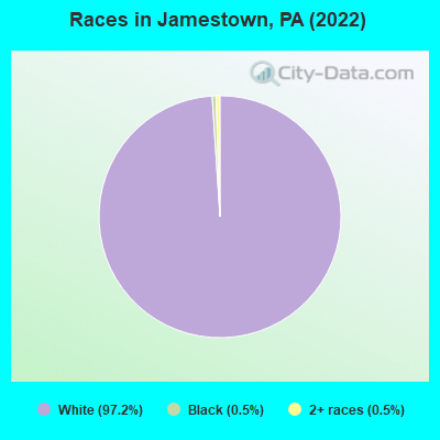
Races in Jamestown detailed stats: ancestries, foreign born residents, place of birth
According to our research of Pennsylvania and other state lists, there were 5 registered sex offenders living in Jamestown, Pennsylvania as of April 27, 2024.
The ratio of all residents to sex offenders in Jamestown is 124 to 1.
Type |
2009 |
2010 |
2011 |
2012 |
2013 |
2014 |
2015 |
2016 |
2017 |
2018 |
2019 |
2020 |
2021 |
2022 |
|---|---|---|---|---|---|---|---|---|---|---|---|---|---|---|
| Murders (per 100,000) | 0 (0.0) | 0 (0.0) | 0 (0.0) | 0 (0.0) | 0 (0.0) | 0 (0.0) | 0 (0.0) | 0 (0.0) | 0 (0.0) | 0 (0.0) | 0 (0.0) | 0 (0.0) | 0 (0.0) | 0 (0.0) |
| Rapes (per 100,000) | 0 (0.0) | 0 (0.0) | 0 (0.0) | 0 (0.0) | 0 (0.0) | 0 (0.0) | 0 (0.0) | 0 (0.0) | 0 (0.0) | 0 (0.0) | 0 (0.0) | 0 (0.0) | 0 (0.0) | 0 (0.0) |
| Robberies (per 100,000) | 0 (0.0) | 0 (0.0) | 0 (0.0) | 0 (0.0) | 0 (0.0) | 0 (0.0) | 0 (0.0) | 0 (0.0) | 0 (0.0) | 0 (0.0) | 0 (0.0) | 0 (0.0) | 0 (0.0) | 0 (0.0) |
| Assaults (per 100,000) | 0 (0.0) | 0 (0.0) | 0 (0.0) | 1 (162.9) | 0 (0.0) | 1 (167.8) | 1 (167.8) | 1 (169.2) | 1 (171.8) | 1 (173.3) | 1 (174.8) | 0 (0.0) | 0 (0.0) | 0 (0.0) |
| Burglaries (per 100,000) | 1 (175.1) | 1 (162.1) | 1 (161.6) | 0 (0.0) | 4 (661.2) | 1 (167.8) | 0 (0.0) | 0 (0.0) | 1 (171.8) | 0 (0.0) | 0 (0.0) | 0 (0.0) | 1 (177.6) | 0 (0.0) |
| Thefts (per 100,000) | 9 (1,576) | 12 (1,945) | 6 (969.3) | 7 (1,140) | 8 (1,322) | 13 (2,181) | 2 (335.6) | 4 (676.8) | 4 (687.3) | 4 (693.2) | 4 (699.3) | 1 (176.1) | 2 (355.2) | 5 (874.1) |
| Auto thefts (per 100,000) | 1 (175.1) | 0 (0.0) | 0 (0.0) | 0 (0.0) | 1 (165.3) | 0 (0.0) | 0 (0.0) | 0 (0.0) | 0 (0.0) | 0 (0.0) | 0 (0.0) | 0 (0.0) | 1 (177.6) | 0 (0.0) |
| Arson (per 100,000) | 0 (0.0) | 0 (0.0) | 0 (0.0) | 0 (0.0) | 0 (0.0) | 0 (0.0) | 0 (0.0) | 0 (0.0) | 0 (0.0) | 0 (0.0) | 0 (0.0) | 0 (0.0) | 0 (0.0) | 0 (0.0) |
| City-Data.com crime index | 89.3 | 89.1 | 50.1 | 78.2 | 112.4 | 132.6 | 47.0 | 60.9 | 73.9 | 62.4 | 62.9 | 7.0 | 40.9 | 35.0 |
The City-Data.com crime index weighs serious crimes and violent crimes more heavily. Higher means more crime, U.S. average is 246.1. It adjusts for the number of visitors and daily workers commuting into cities.
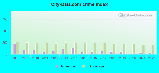
Crime rate in Jamestown detailed stats: murders, rapes, robberies, assaults, burglaries, thefts, arson
Full-time law enforcement employees in 2009, including police officers: 1 (1 officers - 1 male; 0 female).
| Officers per 1,000 residents here: | 1.75 |
| Pennsylvania average: | 2.63 |
 Recent articles from our blog. Our writers, many of them Ph.D. graduates or candidates, create easy-to-read articles on a wide variety of topics.

 | Pittsburgh ranked cloudiest city in the USA (80 replies) |
| Long weekend in ANF - Warren, Kane or Bradford for restaurants, breweries, etc...? (15 replies) |
| peaceful protest (155 replies) |
| UPMC's greed and complete disservice to our community. Non-profit status? I think not! (294 replies) |
| Best Driving Route from Pittsburgh PA to Cooperstown NY (23 replies) |
| Coudersport PA, anyone know this area? (35 replies) |
Latest news from Jamestown, PA collected exclusively by city-data.com from local newspapers, TV, and radio stations
Ancestries: English (22.9%), Irish (17.8%), American (12.7%), German (6.8%), Italian (6.8%), Dutch (3.0%).
Current Local Time: EST time zone
Incorporated in 1854
Land area: 0.78 square miles.
Population density: 742 people per square mile (low).
11 residents are foreign born
| This borough: | 1.7% |
| Pennsylvania: | 7.3% |
Median real estate property taxes paid for housing units with mortgages in 2022: $1,211 (1.2%)
Median real estate property taxes paid for housing units with no mortgage in 2022: $1,050 (1.2%)
Nearest city with pop. 50,000+: Youngstown, OH  (29.1 miles , pop. 82,026).
Nearest city with pop. 200,000+: Akron, OH (63.0 miles , pop. 217,074).
Nearest city with pop. 1,000,000+: Philadelphia, PA (295.8 miles , pop. 1,517,550).
Nearest cities:
), ), ), )Latitude: 41.49 N, Longitude: 80.44 W
Area code commonly used in this area: 724

| Here: | 3.3% |
| Pennsylvania: | 2.9% |
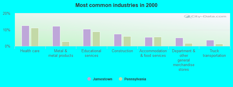
- Health care (12.6%)
- Metal & metal products (12.2%)
- Educational services (10.4%)
- Construction (7.4%)
- Accommodation & food services (5.6%)
- Department & other general merchandise stores (5.2%)
- Truck transportation (3.7%)
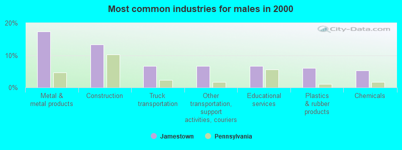
- Metal & metal products (17.3%)
- Construction (13.3%)
- Truck transportation (6.7%)
- Other transportation, support activities, couriers (6.7%)
- Educational services (6.7%)
- Plastics & rubber products (6.0%)
- Chemicals (5.3%)
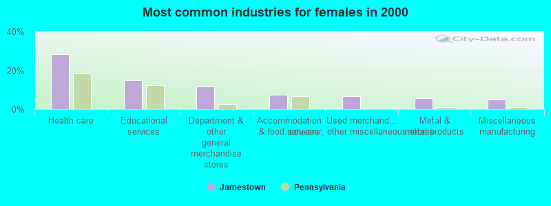
- Health care (28.3%)
- Educational services (15.0%)
- Department & other general merchandise stores (11.7%)
- Accommodation & food services (7.5%)
- Used merchandise, gift, novelty, souvenir, other miscellaneous stores (6.7%)
- Metal & metal products (5.8%)
- Miscellaneous manufacturing (5.0%)

- Other production occupations, including supervisors (7.4%)
- Retail sales workers, except cashiers (6.7%)
- Laborers and material movers, hand (6.3%)
- Building and grounds cleaning and maintenance occupations (5.2%)
- Cashiers (5.2%)
- Material recording, scheduling, dispatching, and distributing workers (4.8%)
- Cooks and food preparation workers (4.1%)
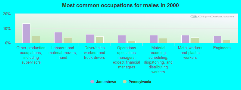
- Other production occupations, including supervisors (13.3%)
- Laborers and material movers, hand (7.3%)
- Driver/sales workers and truck drivers (6.0%)
- Operations specialties managers, except financial managers (5.3%)
- Material recording, scheduling, dispatching, and distributing workers (5.3%)
- Metal workers and plastic workers (5.3%)
- Engineers (4.7%)

- Building and grounds cleaning and maintenance occupations (11.7%)
- Cashiers (11.7%)
- Retail sales workers, except cashiers (9.2%)
- Secretaries and administrative assistants (6.7%)
- Health technologists and technicians (5.0%)
- Supervisors and other personal care and service workers, except child care workers (5.0%)
- Other sales and related occupations, including supervisors (5.0%)
Average climate in Jamestown, Pennsylvania
Based on data reported by over 4,000 weather stations


(lower is better)
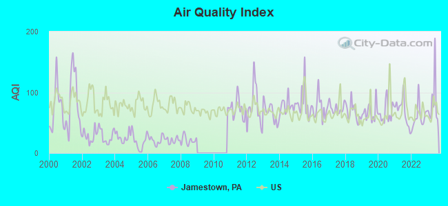
Air Quality Index (AQI) level in 2023 was 83.4. This is about average.
| City: | 83.4 |
| U.S.: | 72.6 |
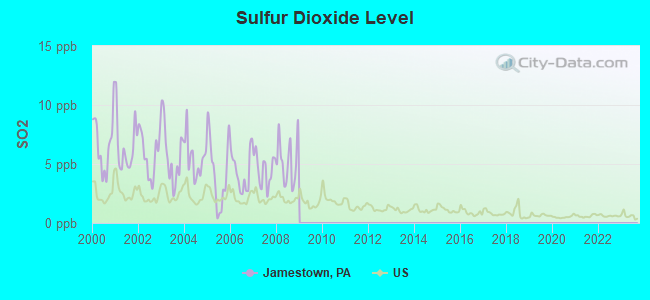
Sulfur Dioxide (SO2) [ppb] level in 2008 was 5.26. This is significantly worse than average. Closest monitor was 15.8 miles away from the city center.
| City: | 5.26 |
| U.S.: | 1.51 |
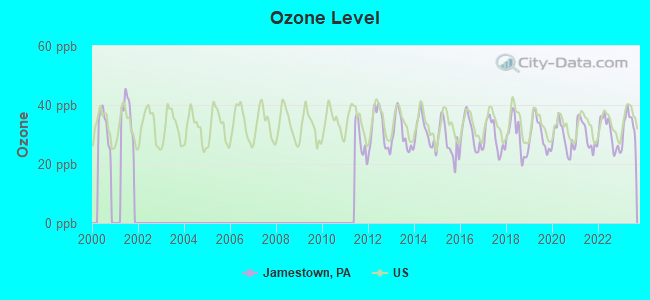
Ozone [ppb] level in 2023 was 33.2. This is about average. Closest monitor was 8.1 miles away from the city center.
| City: | 33.2 |
| U.S.: | 33.3 |
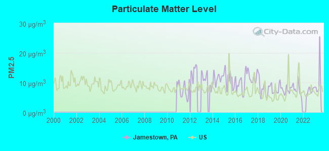
Particulate Matter (PM2.5) [µg/m3] level in 2023 was 10.3. This is worse than average. Closest monitor was 18.9 miles away from the city center.
| City: | 10.3 |
| U.S.: | 8.1 |
Tornado activity:
Jamestown-area historical tornado activity is slightly above Pennsylvania state average. It is 5% smaller than the overall U.S. average.
On 5/31/1985, a category F5 (max. wind speeds 261-318 mph) tornado 20.4 miles away from the Jamestown borough center killed 18 people and injured 310 people and caused between $50,000,000 and $500,000,000 in damages.
On 5/31/1985, a category F4 (max. wind speeds 207-260 mph) tornado 4.3 miles away from the borough center killed 16 people and injured 125 people and caused between $5,000,000 and $50,000,000 in damages.
Earthquake activity:
Jamestown-area historical earthquake activity is significantly above Pennsylvania state average. It is 58% smaller than the overall U.S. average.On 9/25/1998 at 19:52:52, a magnitude 5.2 (4.8 MB, 4.3 MS, 5.2 LG, 4.5 MW, Depth: 3.1 mi, Class: Moderate, Intensity: VI - VII) earthquake occurred 2.2 miles away from Jamestown center
On 1/31/1986 at 16:46:43, a magnitude 5.0 (5.0 MB) earthquake occurred 38.2 miles away from Jamestown center
On 8/23/2011 at 17:51:04, a magnitude 5.8 (5.8 MW, Depth: 3.7 mi) earthquake occurred 280.9 miles away from Jamestown center
On 12/31/2011 at 20:05:01, a magnitude 4.0 (4.0 ML, Depth: 3.1 mi, Class: Light, Intensity: IV - V) earthquake occurred 28.3 miles away from the city center
On 6/10/2019 at 14:50:45, a magnitude 4.0 (4.0 MB, Depth: 1.2 mi) earthquake occurred 54.3 miles away from the city center
On 1/26/2001 at 03:03:20, a magnitude 3.9 (3.9 MB, Depth: 3.1 mi, Class: Light, Intensity: II - III) earthquake occurred 36.7 miles away from Jamestown center
Magnitude types: regional Lg-wave magnitude (LG), body-wave magnitude (MB), local magnitude (ML), surface-wave magnitude (MS), moment magnitude (MW)
Natural disasters:
The number of natural disasters in Mercer County (10) is smaller than the US average (15).Major Disasters (Presidential) Declared: 6
Emergencies Declared: 4
Causes of natural disasters: Floods: 3, Storms: 3, Hurricanes: 2, Tornadoes: 2, Snowfall: 1, Snowstorm: 1, Tropical Storm: 1, Wind: 1, Winter Storm: 1, Other: 1 (Note: some incidents may be assigned to more than one category).
Hospitals and medical centers near Jamestown:
- SAINT PAUL HOMES (Nursing Home, about 5 miles away; GREENVILLE, PA)
- UPMC HORIZON Acute Care Hospitals (about 7 miles away; GREENVILLE, PA)
- UPMC HORIZON HOSPICE (Hospital, about 7 miles away; GREENVILLE, PA)
- WHITE CLIFF HEALTH AND REHABILITATION CENTER (Nursing Home, about 8 miles away; GREENVILLE, PA)
- UPMC/JEFFERSON REGIONAL HOME HEALTH, LP (Home Health Center, about 8 miles away; KINSMAN, OH)
- BOYD'S KINSMAN HOME (Hospital, about 10 miles away; KINSMAN, OH)
- ANDOVER DIALYSIS (Dialysis Facility, about 11 miles away; ANDOVER, OH)
Colleges/universities with over 2000 students nearest to Jamestown:
- Allegheny College (about 19 miles; Meadville, PA; Full-time enrollment: 2,249)
- Youngstown State University (about 29 miles; Youngstown, OH; FT enrollment: 11,575)
- Grove City College (about 30 miles; Grove City, PA; FT enrollment: 2,560)
- Edinboro University of Pennsylvania (about 32 miles; Edinboro, PA; FT enrollment: 6,746)
- Slippery Rock University of Pennsylvania (about 36 miles; Slippery Rock, PA; FT enrollment: 8,424)
- Mercyhurst University (about 48 miles; Erie, PA; FT enrollment: 2,888)
- Gannon University (about 48 miles; Erie, PA; FT enrollment: 3,760)
Public high school in Jamestown:
- JAMESTOWN AREA JSHS (Students: 331, Location: 204 SHENANGO STREET, Grades: 7-12)
Public elementary/middle school in Jamestown:
- JAMESTOWN AREA EL SCH (Students: 311, Location: 3938 DOUTHETT DRIVE, Grades: KG-6)
Points of interest:
Notable location: Jamestown Volunteer Fire Department (A). Display/hide its location on the map
Drinking water stations with addresses in Jamestown and their reported violations in the past:
WHITE HAVEN CAMPGROUND (Population served: 300, Groundwater):Past monitoring violations:PYMATUNING SP JAMESTOWN CG (Population served: 200, Groundwater):
- Monitoring, Source Water (GWR) - Between JAN-02-2012 and FEB-02-2012, Contaminant: E. COLI. Follow-up actions: St Public Notif requested (JAN-24-2012), St Violation/Reminder Notice (JAN-24-2012), St Compliance achieved (JAN-24-2012), St Public Notif received (JAN-25-2012)
- Monitoring, Repeat Major (TCR) - Between OCT-2011 and DEC-2011, Contaminant: Coliform (TCR). Follow-up actions: St Public Notif requested (JAN-24-2012), St Violation/Reminder Notice (JAN-24-2012), St Compliance achieved (JAN-24-2012), St Public Notif received (JAN-25-2012)
- 2 routine major monitoring violations
- One minor monitoring violation
Past health violations:SHANGRI LA BY THE LAKE CG (Population served: 100, Groundwater):
- MCL, Monthly (TCR) - Between APR-2006 and JUN-2006, Contaminant: Coliform. Follow-up actions: St Public Notif requested (AUG-15-2006), St Public Notif received (AUG-15-2006), St Compliance achieved (AUG-15-2006), St Violation/Reminder Notice (AUG-15-2006)
Past health violations:PYMATUNING SP GROUP CAMPGROUND (Population served: 100, Groundwater):Past monitoring violations:
- MCL, Monthly (TCR) - Between APR-2008 and JUN-2008, Contaminant: Coliform. Follow-up actions: St Public Notif requested (JUL-02-2008), St Public Notif received (JUL-02-2008), St Compliance achieved (JUL-02-2008), St Formal NOV issued (JUL-02-2008)
- 2 routine major monitoring violations
Past monitoring violations:SHENANGO VALLEY BOAT CLUB INC (Population served: 65, Groundwater):
- Monitoring, Source Water (GWR) - Between OCT-07-2012 and NOV-07-2012, Contaminant: E. COLI. Follow-up actions: St Public Notif requested (NOV-28-2012), St Violation/Reminder Notice (NOV-28-2012), St Compliance achieved (NOV-28-2012), St Public Notif received (APR-22-2013)
- 2 routine major monitoring violations
Past monitoring violations:WELCOME INN (Population served: 30, Groundwater):
- 2 routine major monitoring violations
Past monitoring violations:WESTFORD UNITED METHODIST (Population served: 25, Groundwater):
- One routine major monitoring violation
Past monitoring violations:WALNUT CREEK GOLF CLUB (Population served: 25, Groundwater):
- Monitoring, Source Water (GWR) - In OCT-2010, Contaminant: E. COLI. Follow-up actions: St Public Notif requested (DEC-15-2010), St Compliance achieved (DEC-15-2010), St Violation/Reminder Notice (DEC-15-2010)
- Monitoring, Repeat Major (TCR) - Between JUL-2010 and SEP-2010, Contaminant: Coliform (TCR). Follow-up actions: St Violation/Reminder Notice (NOV-16-2010), St Compliance achieved (NOV-16-2010), St Public Notif requested (NOV-16-2010)
- 3 routine major monitoring violations
- One minor monitoring violation
Past monitoring violations:
- 3 routine major monitoring violations
- One regular monitoring violation
Drinking water stations with addresses in Jamestown that have no violations reported:
- PYMATUNING WATERFOWL MUSEUM (Population served: 273, Primary Water Source Type: Groundwater)
- PYMATUNING SP JAMESTOWN BEACH (Population served: 200, Primary Water Source Type: Groundwater)
- PSP ESPYVILLE LAUNCH (Population served: 100, Primary Water Source Type: Groundwater)
- PSP ESPYVILLE LIVERY NEW (Population served: 100, Primary Water Source Type: Groundwater)
- COUNTRY VILLAGE MOBILE ESTATES (Population served: 97, Primary Water Source Type: Groundwater)
- PYMATUNING SP MCARTHUR BOAT (Population served: 25, Primary Water Source Type: Groundwater)
- PYMATUNING SNODGRASS BOAT (Population served: 25, Primary Water Source Type: Groundwater)
- PYMATUNING SP MANNING BOAT (Population served: 25, Primary Water Source Type: Groundwater)
- PYMATUNING SP SHELTER #9 (Population served: 25, Primary Water Source Type: Groundwater)
| This borough: | 2.4 people |
| Pennsylvania: | 2.5 people |
| This borough: | 68.6% |
| Whole state: | 65.0% |
| This borough: | 7.8% |
| Whole state: | 6.6% |
No gay or lesbian households reported
Banks with branches in Jamestown (2011 data):
- First National Bank of Pennsylvania: Jamestown Branch at 126 Liberty Street, branch established on 1952/12/01. Info updated 2012/01/10: Bank assets: $9,581.0 mil, Deposits: $7,462.2 mil, headquarters in Greenville, PA, positive income, Commercial Lending Specialization, 291 total offices, Holding Company: F.N.b. Corporation
For population 15 years and over in Jamestown:
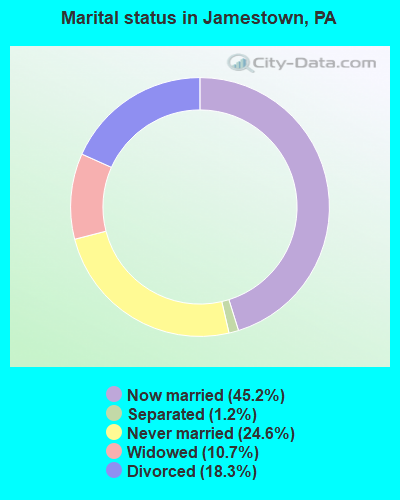
- Never married: 24.6%
- Now married: 45.2%
- Separated: 1.2%
- Widowed: 10.7%
- Divorced: 18.3%
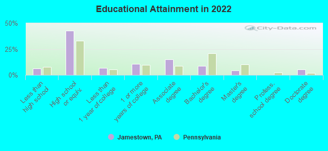
For population 25 years and over in Jamestown:
- High school or higher: 90.9%
- Bachelor's degree or higher: 14.8%
- Graduate or professional degree: 6.8%
- Unemployed: 8.5%
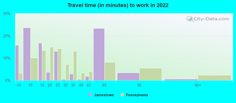
- Mean travel time to work (commute): 24.0 minutes
| Here: | 10.1 |
| Pennsylvania average: | 11.4 |
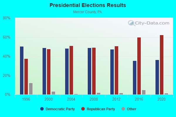
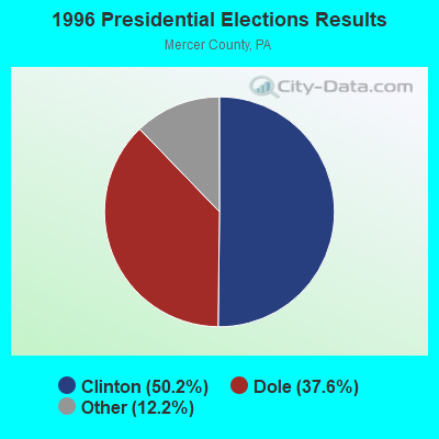
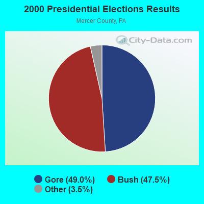

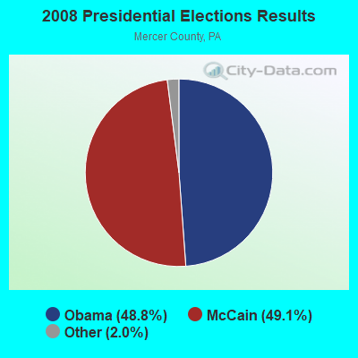
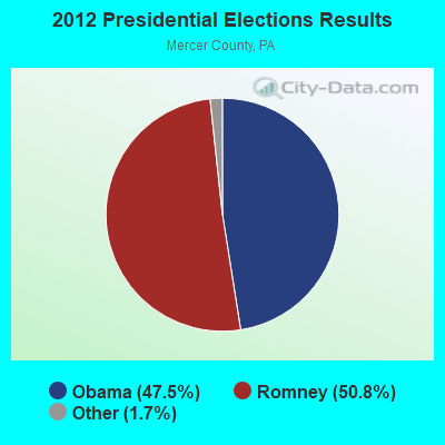


Graphs represent county-level data. Detailed 2008 Election Results
Religion statistics for Jamestown, PA (based on Mercer County data)
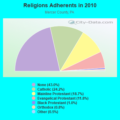
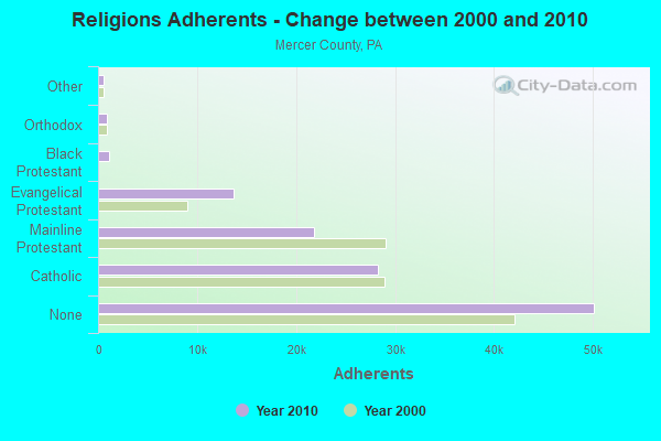
| Religion | Adherents | Congregations |
|---|---|---|
| Catholic | 28,244 | 15 |
| Mainline Protestant | 21,831 | 78 |
| Evangelical Protestant | 13,739 | 94 |
| Black Protestant | 1,147 | 7 |
| Orthodox | 929 | 6 |
| Other | 612 | 9 |
| None | 50,136 | - |
Food Environment Statistics:
| Mercer County: | 1.97 / 10,000 pop. |
| State: | 2.04 / 10,000 pop. |
| Here: | 0.09 / 10,000 pop. |
| State: | 0.09 / 10,000 pop. |
| This county: | 0.60 / 10,000 pop. |
| Pennsylvania: | 0.88 / 10,000 pop. |
| Mercer County: | 2.74 / 10,000 pop. |
| State: | 2.52 / 10,000 pop. |
| This county: | 6.93 / 10,000 pop. |
| Pennsylvania: | 7.12 / 10,000 pop. |
| This county: | 10.5% |
| State: | 9.1% |
| This county: | 29.4% |
| Pennsylvania: | 27.2% |
| Here: | 13.9% |
| Pennsylvania: | 11.5% |
Health and Nutrition:
| Here: | 60.0% |
| State: | 50.2% |
| Here: | 50.0% |
| Pennsylvania: | 47.1% |
| Jamestown: | 30.8 |
| State: | 28.7 |
| Here: | 20.0% |
| Pennsylvania: | 20.8% |
| Here: | 6.6 |
| Pennsylvania: | 6.8 |
| Here: | 65.0% |
| Pennsylvania: | 56.2% |
| Here: | 80.0% |
| Pennsylvania: | 78.3% |
More about Health and Nutrition of Jamestown, PA Residents
| Local government employment and payroll (March 2022) | |||||
| Function | Full-time employees | Monthly full-time payroll | Average yearly full-time wage | Part-time employees | Monthly part-time payroll |
|---|---|---|---|---|---|
| Streets and Highways | 1 | $2,611 | $31,332 | 0 | $0 |
| Financial Administration | 0 | $0 | 1 | $3,054 | |
| Police Protection - Officers | 0 | $0 | 4 | $1,966 | |
| Totals for Government | 1 | $2,611 | $31,332 | 5 | $5,020 |
Jamestown government finances - Expenditure in 2017 (per resident):
- Current Operations - Water Utilities: $109,000 ($189.24)
Sewerage: $107,000 ($185.76)
Central Staff Services: $77,000 ($133.68)
Regular Highways: $53,000 ($92.01)
Police Protection: $34,000 ($59.03)
General - Other: $24,000 ($41.67)
Local Fire Protection: $8,000 ($13.89)
Protective Inspection and Regulation - Other: $1,000 ($1.74)
- General - Interest on Debt: $2,000 ($3.47)
Jamestown government finances - Revenue in 2017 (per resident):
- Charges - Sewerage: $154,000 ($267.36)
- Miscellaneous - Donations From Private Sources: $5,000 ($8.68)
Fines and Forfeits: $2,000 ($3.47)
Interest Earnings: $1,000 ($1.74)
- Revenue - Water Utilities: $146,000 ($253.47)
- State Intergovernmental - Other: $26,000 ($45.14)
- Tax - Property: $117,000 ($203.12)
Individual Income: $54,000 ($93.75)
Occupation and Business License - Other: $16,000 ($27.78)
Public Utility License: $8,000 ($13.89)
Documentary and Stock Transfer: $4,000 ($6.94)
Jamestown government finances - Debt in 2017 (per resident):
- Long Term Debt - Retired Unspecified Public Purpose: $50,000 ($86.81)
Beginning Outstanding - Unspecified Public Purpose: $47,000 ($81.60)
Issue, Unspecified Public Purpose: $34,000 ($59.03)
Outstanding Unspecified Public Purpose: $31,000 ($53.82)
Jamestown government finances - Cash and Securities in 2017 (per resident):
- Other Funds - Cash and Securities: $538,000 ($934.03)
Strongest AM radio stations in Jamestown:
- WKNR (850 AM; 50 kW; CLEVELAND, OH; Owner: CARON BROADCASTING, INC.)
- WTAM (1100 AM; 50 kW; CLEVELAND, OH; Owner: JACOR BROADCASTING CORPORATION)
- KDKA (1020 AM; 50 kW; PITTSBURGH, PA; Owner: INFINITY BROADCASTING OPERATIONS, INC.)
- WHK (1220 AM; 50 kW; CLEVELAND, OH; Owner: CARON BROADCASTING, INC.)
- WNIO (1390 AM; 10 kW; YOUNGSTOWN, OH; Owner: YOUNGSTOWN RADIO LICENSE, L.L.C.)
- WKBN (570 AM; 5 kW; YOUNGSTOWN, OH; Owner: CITICASTERS LICENSES, L.P.)
- WFUN (970 AM; 5 kW; ASHTABULA, OH; Owner: CLEAR CHANNEL BROADCASTING LICENSES, INC.)
- WWVA (1170 AM; 53 kW; WHEELING, WV; Owner: CAPSTAR TX LIMITED PARTNERSHIP)
- WKTX (830 AM; daytime; 1 kW; CORTLAND, OH; Owner: MIKLOS KOSSANYI, MARIA KOSSANYI)
- WWOW (1360 AM; 5 kW; CONNEAUT, OH; Owner: WWOW BROADCASTING, INC.)
- WHKW (1440 AM; 5 kW; WARREN, OH; Owner: SCA LICENSE CORPORATION)
- WPIC (790 AM; 1 kW; SHARON, PA; Owner: CUMULUS LICENSING CORP.)
- WKST (1200 AM; 5 kW; NEW CASTLE, PA; Owner: CITICASTERS LICENSES, L.P.)
Strongest FM radio stations in Jamestown:
- WICT (95.1 FM; GROVE CITY, PA; Owner: YOUNGSTOWN RADIO LICENSE, L.L.C.)
- WEXC (107.1 FM; GREENVILLE, PA; Owner: BEACON BROADCASTING, INC.)
- WMXY (98.9 FM; YOUNGSTOWN, OH; Owner: CITICASTERS LICENSES, L.P.)
- WGYY (100.3 FM; MEADVILLE, PA; Owner: FOREVER BROADCASTING, LLC)
- WLLF (96.7 FM; MERCER, PA; Owner: CUMULUS LICENSING CORP.)
- WHUZ (94.3 FM; SAEGERTOWN, PA; Owner: FOREVER BROADCASTING, LLC)
- WCVJ (90.9 FM; JEFFERSON, OH; Owner: AGAPE SCHOOL, INC.)
- WWIZ (103.9 FM; MERCER, PA; Owner: CUMULUS LICENSING CORP.)
- WVME (91.9 FM; MEADVILLE, PA; Owner: THE MOODY BIBLE INSTITUTE OF CHICAGO)
- WHOT-FM (101.1 FM; YOUNGSTOWN, OH; Owner: CUMULUS LICENSING CORP.)
- WMVL (101.7 FM; LINESVILLE, PA; Owner: VILKIE COMMUNICATIONS, INC.)
- WAKZ (95.9 FM; SHARPSVILLE, PA; Owner: YOUNGSTOWN RADIO LICENSE, L.L.C.)
- WYTN (91.7 FM; YOUNGSTOWN, OH; Owner: FAMILY STATIONS, INC.)
- WYFM (102.9 FM; SHARON, PA; Owner: CUMULUS LICENSING CORP.)
- WUSE (93.9 FM; FAIRVIEW, PA; Owner: NM LICENSING, LLC)
- WOXX (99.3 FM; FRANKLIN, PA; Owner: FOREVER BROADCASTING, LLC)
- WREO-FM (97.1 FM; ASHTABULA, OH; Owner: CLEAR CHANNEL BROADCASTING LICENSES, INC.)
- WXXO (104.5 FM; CAMBRIDGE SPRINGS, PA; Owner: FOREVER BROADCASTING, LLC)
- WBBG (106.1 FM; NILES, OH; Owner: CITICASTERS LICENSES, L.P.)
- WTGP (88.1 FM; GREENVILLE, PA; Owner: THIEL COLLEGE)
TV broadcast stations around Jamestown:
- WFXI-CA (Channel 17; MERCER, PA; Owner: PIEDMONT TELEVISION OF YOUNGSTOWN LICENSE LLC)
- WKBN-TV (Channel 27; YOUNGSTOWN, OH; Owner: PIEDMONT TELEVISION OF YOUNGSTOWN LICENSE LLC)
- WFMJ-TV (Channel 21; YOUNGSTOWN, OH; Owner: WFMJ TELEVISION, INC.)
- W52BO (Channel 52; MEADVILLE, PA; Owner: TRINITY BROADCASTING NETWORK)
- WYFX-LP (Channel 62; YOUNGSTOWN, OH; Owner: PIEDMONT TELEVISION OF YOUNGSTOWN LICENSE LLC)
- W50BF (Channel 50; SHARON, PA; Owner: CORNERSTONE TELEVISION, INC.)
- WYTV (Channel 33; YOUNGSTOWN, OH; Owner: CHELSEY BROADCASTING COMPANY OF YOUNGSTOWN, LLC)
Jamestown fatal accident list:
- National Bridge Inventory (NBI) Statistics
- 6Number of bridges
- 36ft / 11.4mTotal length
- $1,799,000Total costs
- 8,881Total average daily traffic
- 750Total average daily truck traffic
- 13,395Total future (year 2032) average daily traffic
FCC Registered Cell Phone Towers:
1- Tw Route 307 Snake Road (96044) (Lat: 41.499111 Lon: -80.428722), Type: Gtower, Structure height: 57.3 m, Call Sign: KNKN937, Licensee ID: L00128694
Assigned Frequencies: 869.040 MHz, 869.040 MHz, 869.040 MHz, 824.040 MHz, 824.040 MHz, 824.040 MHz, 890.010 MHz, 890.010 MHz, 890.010 MHz, 845.010 MHz, 845.010 MHz, 845.010 MHzGrant Date: 09/08/2021, Expiration Date: 10/01/2031, Certifier: Michael P GogginRegistrant: New Cingular Wireless Pcs, LLC
FCC Registered Antenna Towers:
5- Sean M Boylan, 7451 Scott Rd (Stc-214-Pa) (Lat: 41.560583 Lon: -80.455444), Type: 60.6, Structure height: 42039 m, Overall height: 59.4 m, Registrant: Stc Towers, LLC, Sboylan@stc-Towers.Com, , Warsa-w, Phone: (574) 269-4444
- Sean M Boylan, 7451 Scott Rd (Stc-214-Pa) (Lat: 41.560583 Lon: -80.455444), Type: 60.6, Structure height: 42039 m, Overall height: 59.4 m, Registrant: Stc Towers, LLC, Sboylan@stc-Towers.Com, , Warsa-w, Phone: (574) 269-4444
- Sean M Boylan, 7451 Scott Rd (Stc-214-Pa) (Lat: 41.560583 Lon: -80.455444), Type: 60.6, Structure height: 42039 m, Overall height: 59.4 m, Registrant: Stc Towers, LLC, Sboylan@stc-Towers.Com, , Warsa-w, Phone: (574) 269-4444
- Dawn L Keniley, 7451 Scott Rd (Stc-214-Pa) (Lat: 41.560583 Lon: -80.455444), Type: 60.6, Structure height: 42039 m, Overall height: 59.4 m, Registrant: Vertical Bridge Development, LLC, Fcc-Faa@verticalbridge.Com, Suite 200, Boca -Raton, Phone: (561) 406-4015
- Donna Kellison, 7451 Scott Rd (Stc-214-Pa) (Lat: 41.560583 Lon: -80.455444), Type: 60.6, Structure height: 42039 m, Overall height: 59.4 m, Registrant: Vb Bts, LLC, Fccsecuritization@verticalbridge.Com, Suite 200, Boca -Raton, Phone: (561) 406-4015
FCC Registered Broadcast Land Mobile Towers:
5- Corner Of Rt 322 & Jackson St (Lat: 41.486167 Lon: -80.437000), Call Sign: KGD416,
Assigned Frequencies: 33.8200 MHz, 33.8800 MHz, 33.9800 MHz, Grant Date: 02/10/2023, Expiration Date: 05/09/2033, Registrant: Mercer County Dept Of Public Safety, 205 S Erie St, Mercer, PA 16137, Phone: (724) 662-6100, Fax: (724) 662-0100, Email:
- Pymatunging State Park (Lat: 41.500056 Lon: -80.466472), Call Sign: KGG613,
Assigned Frequencies: 153.860 MHz, Grant Date: 07/29/2022, Expiration Date: 08/20/2032, Registrant: Commonwealth Of Pa Dept. Of Conservation & Natural Resources, 400 Market St., Harrisburg, PA 17101, Phone: (717) 346-1358, Fax: (717) 787-8624, Email:
- Lat: 41.484694 Lon: -80.437806, Call Sign: WPXI383,
Assigned Frequencies: 461.025 MHz, 461.075 MHz, 461.100 MHz, 461.125 MHz, 462.375 MHz, 462.400 MHz, 464.600 MHz, 464.625 MHz, 464.650 MHz, 464.725 MHz, 464.750 MHz, Grant Date: 01/23/2013, Expiration Date: 04/10/2023, Cancellation Date: 06/10/2023, Certifier: Lou Ann Openo, Registrant: Atlas License Company, 7202 N .Shadeland Ave., Ste. 215, Indianapolis, IN 46250, Phone: (317) 813-4865, Fax: (317) 813-4870, Email:
- Lat: 41.484917 Lon: -80.426806, Call Sign: WQSL748,
Assigned Frequencies: 151.550 MHz, 151.730 MHz, Grant Date: 10/28/2013, Expiration Date: 10/28/2023, Cancellation Date: 12/30/2023, Certifier: Bruce R Sankey, Registrant: Mobilcom, Meadville, PA 16335, Phone: (814) 724-1234, Fax: (814) 337-1234, Email:
- Lat: 41.551250 Lon: -80.475889, Call Sign: WRQF891,
Assigned Frequencies: 156.127 MHz, Grant Date: 04/22/2022, Expiration Date: 04/22/2032, Certifier: Jamie J Fries, Registrant: Mobilcom, 16343 Conneaut Lake Rd, Meadville, PA 16335, Phone: (814) 724-1234, Fax: (814) 337-1234, Email:
FCC Registered Microwave Towers:
5- Jamestown HS, Jackson St & Washington St (Lat: 41.485639 Lon: -80.432278), Type: Building, Structure height: 30.5 m, Call Sign: WQJU818,
Assigned Frequencies: 11215.0 MHz, Grant Date: 01/07/2009, Expiration Date: 01/07/2019, Cancellation Date: 03/09/2019, Certifier: Daniel S Suster, Registrant: Conterra Ultra Broadband, LLC., 2101 Rexford Rd Ste 200e, Charlotte, NC 28211, Phone: (704) 936-1777, Fax: (704) 936-1801, Email:
- PT97XC009, Dowling Road (Lat: 41.462806 Lon: -80.467306), Type: Ltower, Structure height: 60.9 m, Call Sign: WQXA392,
Assigned Frequencies: 11325.0 MHz, Grant Date: 01/12/2016, Expiration Date: 01/12/2026, Certifier: David Werblow, Registrant: Dla Piper LLP, 500 8th Street, Nw, Washington, DC 20004, Phone: (202) 799-4216, Fax: (202) 799-5616, Email:
- WESTFORD, 7451 Scott Rd (Stc-214-Pa) (Lat: 41.560583 Lon: -80.455444), Type: Ltower, Structure height: 59.4 m, Overall height: 60.6 m, Call Sign: WRHY947,
Assigned Frequencies: 17980.0 MHz, 18060.0 MHz, 17980.0 MHz, 18060.0 MHz, 17980.0 MHz, 18060.0 MHz, 17980.0 MHz, 18060.0 MHz, 17980.0 MHz, 18060.0 MHz... (+8 more), Grant Date: 07/17/2020, Expiration Date: 07/17/2030, Cancellation Date: 09/21/2023, Certifier: Christophe Le Scanve, Registrant: Cellco Partnership, 5055 North Point Pkwy, Np2ne Network Engineering, Alpharetta, GA 30022, Phone: (770) 797-1070, Email:
- Fangs Nest, 250 Dowling Rd (Lat: 41.462806 Lon: -80.467306), Type: Ltower, Structure height: 50.3 m, Call Sign: WRKV847,
Assigned Frequencies: 10995.0 MHz, 10995.0 MHz, 10995.0 MHz, 10995.0 MHz, 10995.0 MHz, 10995.0 MHz, 10995.0 MHz, 10995.0 MHz, Grant Date: 02/22/2021, Expiration Date: 02/22/2031, Certifier: Tony Kaper, Registrant: Intelpath, Hinsdale, IL 60522, Phone: (312) 841-9188, Email:
- CL34076A, Dowling Rd (Lat: 41.462917 Lon: -80.467417), Type: Ltower, Structure height: 60.4 m, Call Sign: WRVR804,
Assigned Frequencies: 11075.0 MHz, 11075.0 MHz, 11075.0 MHz, 11075.0 MHz, 11075.0 MHz, 11075.0 MHz, 11075.0 MHz, 11075.0 MHz, 11075.0 MHz, 11075.0 MHz... (+5 more), Grant Date: 12/28/2022, Expiration Date: 12/28/2032, Certifier: Jenny Knopf, Registrant: T-Mobile Usa, Inc., 12920 Se 38th Street, Bellevue, WA 98006, Phone: (425) 383-8401, Fax: (425) 383-4040, Email:
FCC Registered Maritime Coast & Aviation Ground Towers:
1- 295 Bush Rd (Lat: 41.529222 Lon: -80.499806), Overall height: 3 m, Call Sign: WHU231, Licensee ID: L00593717,
Assigned Frequencies: 156.425 MHz, 156.800 MHz, 156.450 MHz, Grant Date: 08/29/1997, Expiration Date: 11/03/2002, Cancellation Date: 02/02/2003, Registrant: Pymatuning Yacht Club, 295 Bush Rd, Jamestown, PA 16134
FCC Registered Amateur Radio Licenses:
25 (See the full list of FCC Registered Amateur Radio Licenses in Jamestown)FAA Registered Aircraft:
1- Aircraft: PIPER J3F-65 (Category: Land, Seats: 2, Weight: Up to 12,499 Pounds, Speed: 67 mph), Engine: FRANKLIN 4AC176B SER (65 HP) (Reciprocating)
N-Number: 38542, N38542, N-38542, Serial Number: 7110, Year manufactured: 1941, Airworthiness Date: 03/10/1956, Certificate Issue Date: 11/12/1992
Registrant (Individual): Stanley M Liszka, 148 Bandy Rd, Jamestown, PA 16134
| Home Mortgage Disclosure Act Aggregated Statistics For Year 2009 (Based on 1 partial tract) | ||
| C) Refinancings | ||
|---|---|---|
| Number | Average Value | |
| LOANS ORIGINATED | 1 | $62,380 |
| APPLICATIONS APPROVED, NOT ACCEPTED | 0 | $0 |
| APPLICATIONS DENIED | 0 | $0 |
| APPLICATIONS WITHDRAWN | 0 | $0 |
| FILES CLOSED FOR INCOMPLETENESS | 0 | $0 |
Detailed HMDA statistics for the following Tracts: 0320.00
2003 - 2018 National Fire Incident Reporting System (NFIRS) incidents
- Fire incident types reported to NFIRS in Jamestown, PA
- 33169.8%Structure Fires
- 6613.9%Mobile Property/Vehicle Fires
- 5912.4%Outside Fires
- 183.8%Other
 Based on the data from the years 2003 - 2018 the average number of fires per year is 30. The highest number of fire incidents - 57 took place in 2018, and the least - 9 in 2003. The data has a growing trend.
 When looking into fire subcategories, the most reports belonged to: Structure Fires (69.8%), and Mobile Property/Vehicle Fires (13.9%).
- 79.5%Utility gas
- 14.1%Fuel oil, kerosene, etc.
- 5.4%Electricity
- 1.1%Wood
- 61.5%Utility gas
- 32.5%Electricity
- 3.4%Fuel oil, kerosene, etc.
- 2.6%No fuel used
Jamestown compared to Pennsylvania state average:
- Median household income below state average.
- Median house value significantly below state average.
- Black race population percentage significantly below state average.
- Hispanic race population percentage significantly below state average.
- Median age above state average.
- Foreign-born population percentage significantly below state average.
- Length of stay since moving in below state average.
- Number of college students significantly below state average.
- Percentage of population with a bachelor's degree or higher below state average.
Jamestown on our top lists:
- #83 on the list of "Top 101 cities with the highest percentage of English-only speaking households, population 500+"
- #15 on the list of "Top 101 counties with the highest Particulate Matter (PM2.5) Annual air pollution readings in 2012 (µg/m3)"
- #35 on the list of "Top 101 counties with the lowest percentage of residents relocating from other counties between 2010 and 2011 (pop. 50,000+)"
- #47 on the list of "Top 101 counties with the lowest number of births per 1000 residents 2007-2013"
- #48 on the list of "Top 101 counties with the highest number of deaths per 1000 residents 2007-2013 (pop. 50,000+)"
- #50 on the list of "Top 101 counties with the lowest percentage of residents relocating to other counties in 2011 (pop. 50,000+)"

|
Total of 31 patent applications in 2008-2024.