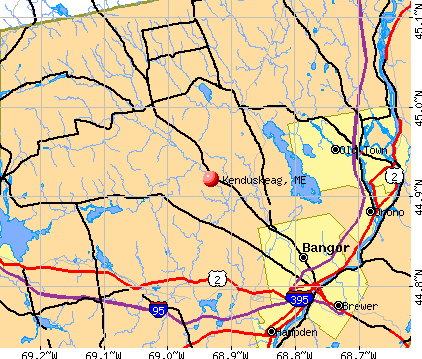
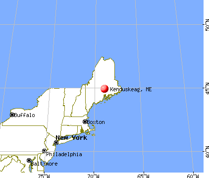
Kenduskeag, Maine
Submit your own pictures of this town and show them to the world
- OSM Map
- General Map
- Google Map
- MSN Map
Population change since 2000: +15.1%
 |
| Males: 677 | |
| Females: 671 |
| Median resident age: | 39.6 years |
| Maine median age: | 43.0 years |
Zip codes: 04450.
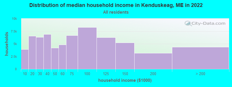
| Kenduskeag: | $61,773 |
| ME: | $69,543 |
Estimated per capita income in 2022: $31,793 (it was $15,815 in 2000)
Kenduskeag town income, earnings, and wages data
Estimated median house or condo value in 2022: $175,640 (it was $67,500 in 2000)
| Kenduskeag: | $175,640 |
| ME: | $290,600 |
Mean prices in 2022: all housing units: $235,563; detached houses: $252,705; townhouses or other attached units: $267,749; in 2-unit structures: $255,332; in 3-to-4-unit structures: $815,300; in 5-or-more-unit structures: $185,873; mobile homes: $93,017; occupied boats, rvs, vans, etc.: $21,333
Detailed information about poverty and poor residents in Kenduskeag, ME


- 1,30496.7%White alone
- 141.0%Hispanic
- 110.8%Two or more races
- 80.6%American Indian alone
- 80.6%Asian alone
- 20.1%Black alone
- 10.07%Other race alone
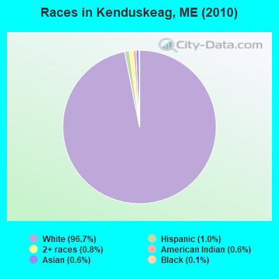
Races in Kenduskeag detailed stats: ancestries, foreign born residents, place of birth
According to our research of Maine and other state lists, there were 3 registered sex offenders living in Kenduskeag, Maine as of April 27, 2024.
The ratio of all residents to sex offenders in Kenduskeag is 449 to 1.
The ratio of registered sex offenders to all residents in this city is near the state average.
 Recent articles from our blog. Our writers, many of them Ph.D. graduates or candidates, create easy-to-read articles on a wide variety of topics.

 | Living in Kenduskeag? Bad? (4 replies) |
| Where would you live in Bangor? (7 replies) |
| Bangor - good place to live, or not? (94 replies) |
| Kenduskeag canoe race (21 replies) |
| Stephen King in Bangor (46 replies) |
| gay-friendly bangor? (26 replies) |
Latest news from Kenduskeag, ME collected exclusively by city-data.com from local newspapers, TV, and radio stations
Ancestries: English (19.7%), French (17.8%), Irish (17.8%), United States (15.1%), German (5.7%), Scottish (4.4%).
Current Local Time: EST time zone
Incorporated on 02/20/1852
Elevation: 127 feet
Land area: 16.8 square miles.
Population density: 80 people per square mile (very low).
9 residents are foreign born
| This town: | 0.8% |
| Maine: | 2.9% |
| Kenduskeag town: | 1.0% ($689) |
| Maine: | 1.5% ($1,417) |
Nearest city with pop. 50,000+: Portland, ME  (109.3 miles , pop. 64,249).
Nearest city with pop. 200,000+: Boston, MA (209.8 miles , pop. 589,141).
Nearest city with pop. 1,000,000+: Bronx, NY (376.9 miles , pop. 1,332,650).
Nearest cities:
), ), ), ), ), ), )Latitude: 44.92 N, Longitude: 68.93 W
Area code commonly used in this area: 207

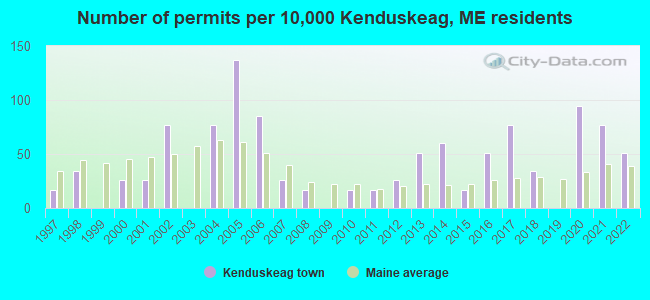
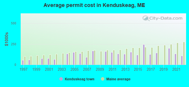
Single-family new house construction building permits:
- 2022: 6 buildings, average cost: $107,500
- 2021: 9 buildings, average cost: $132,200
- 2020: 11 buildings, average cost: $200,000
- 2018: 4 buildings, average cost: $143,000
- 2017: 9 buildings, average cost: $125,000
- 2016: 6 buildings, average cost: $246,000
- 2015: 2 buildings, average cost: $117,500
- 2014: 7 buildings, average cost: $154,500
- 2013: 6 buildings, average cost: $129,600
- 2012: 3 buildings, average cost: $133,300
- 2011: 2 buildings, average cost: $150,000
- 2010: 2 buildings, average cost: $162,500
- 2008: 2 buildings, average cost: $167,500
- 2007: 3 buildings, average cost: $90,300
- 2006: 10 buildings, average cost: $138,200
- 2005: 16 buildings, average cost: $151,900
- 2004: 9 buildings, average cost: $133,700
- 2002: 9 buildings, average cost: $66,800
- 2001: 3 buildings, average cost: $78,300
- 2000: 3 buildings, average cost: $78,300
- 1998: 4 buildings, average cost: $57,500
- 1997: 2 buildings, average cost: $55,700
| Here: | 3.8% |
| Maine: | 3.4% |
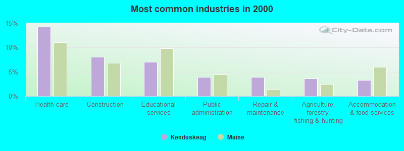
- Health care (14.3%)
- Construction (8.1%)
- Educational services (7.1%)
- Public administration (3.9%)
- Repair & maintenance (3.9%)
- Agriculture, forestry, fishing & hunting (3.6%)
- Accommodation & food services (3.3%)
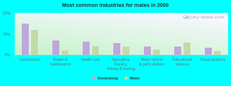
- Construction (15.2%)
- Repair & maintenance (7.1%)
- Health care (6.5%)
- Agriculture, forestry, fishing & hunting (5.8%)
- Motor vehicle & parts dealers (4.2%)
- Educational services (4.2%)
- Wood products (3.5%)
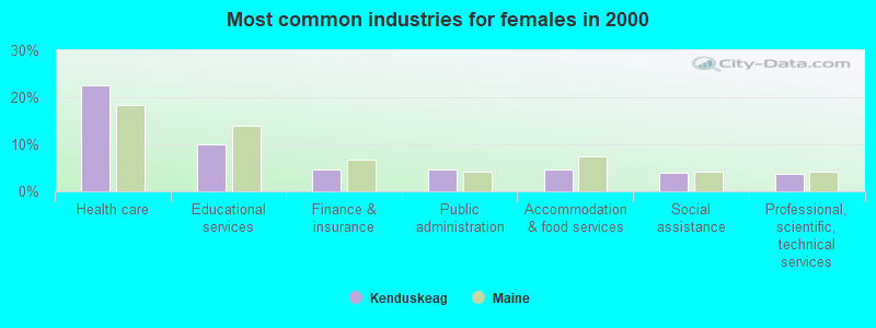
- Health care (22.5%)
- Educational services (10.1%)
- Finance & insurance (4.7%)
- Public administration (4.7%)
- Accommodation & food services (4.7%)
- Social assistance (4.0%)
- Professional, scientific, technical services (3.7%)
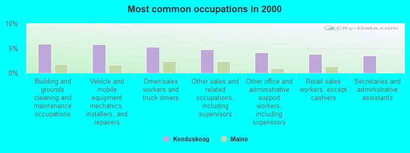
- Building and grounds cleaning and maintenance occupations (5.9%)
- Vehicle and mobile equipment mechanics, installers, and repairers (5.8%)
- Driver/sales workers and truck drivers (5.3%)
- Other sales and related occupations, including supervisors (4.8%)
- Other office and administrative support workers, including supervisors (4.1%)
- Retail sales workers, except cashiers (3.8%)
- Secretaries and administrative assistants (3.5%)
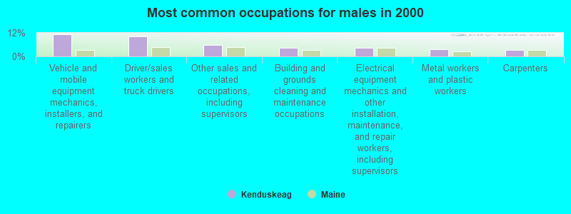
- Vehicle and mobile equipment mechanics, installers, and repairers (11.3%)
- Driver/sales workers and truck drivers (10.3%)
- Other sales and related occupations, including supervisors (5.8%)
- Building and grounds cleaning and maintenance occupations (4.2%)
- Electrical equipment mechanics and other installation, maintenance, and repair workers, including supervisors (4.2%)
- Metal workers and plastic workers (3.5%)
- Carpenters (3.2%)
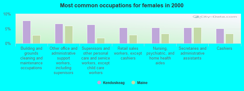
- Building and grounds cleaning and maintenance occupations (7.7%)
- Other office and administrative support workers, including supervisors (6.7%)
- Supervisors and other personal care and service workers, except child care workers (6.4%)
- Retail sales workers, except cashiers (5.4%)
- Nursing, psychiatric, and home health aides (5.4%)
- Secretaries and administrative assistants (5.4%)
- Cashiers (5.0%)
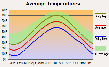
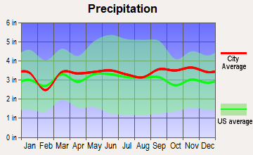
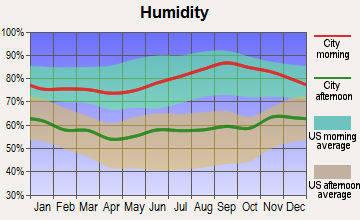
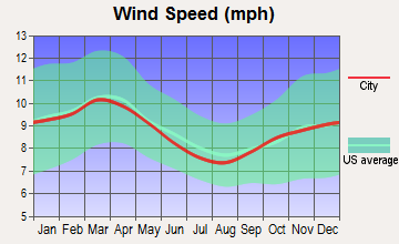
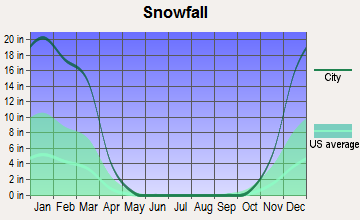
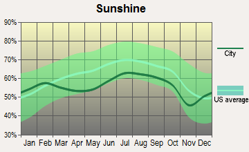
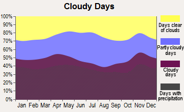
Average climate in Kenduskeag, Maine
Based on data reported by over 4,000 weather stations
(lower is better)
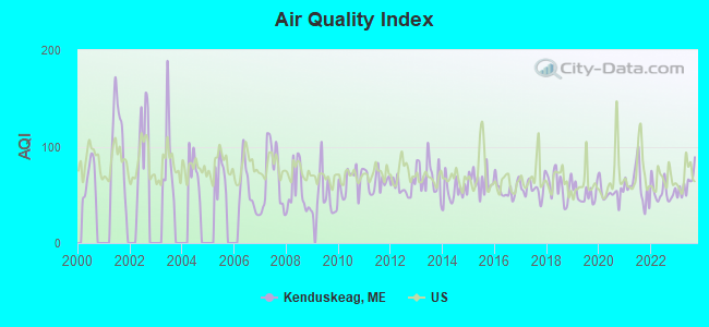
Air Quality Index (AQI) level in 2023 was 61.1. This is about average.
| City: | 61.1 |
| U.S.: | 72.6 |
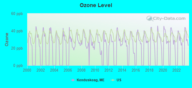
Ozone [ppb] level in 2023 was 33.6. This is about average. Closest monitor was 13.1 miles away from the city center.
| City: | 33.6 |
| U.S.: | 33.3 |
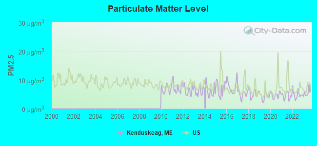
Particulate Matter (PM2.5) [µg/m3] level in 2023 was 5.62. This is significantly better than average. Closest monitor was 10.6 miles away from the city center.
| City: | 5.62 |
| U.S.: | 8.11 |
Earthquake activity:
Kenduskeag-area historical earthquake activity is significantly above Maine state average. It is 81% smaller than the overall U.S. average.On 4/20/2002 at 10:50:47, a magnitude 5.3 (5.3 ML, Depth: 3.0 mi, Class: Moderate, Intensity: VI - VII) earthquake occurred 235.9 miles away from the city center
On 10/16/2012 at 23:12:25, a magnitude 4.7 (4.7 ML, Depth: 10.0 mi, Class: Light, Intensity: IV - V) earthquake occurred 125.3 miles away from Kenduskeag center
On 4/20/2002 at 10:50:47, a magnitude 5.2 (5.2 MB, 4.2 MS, 5.2 MW, 5.0 MW) earthquake occurred 237.2 miles away from Kenduskeag center
On 10/7/1983 at 10:18:46, a magnitude 5.3 (5.1 MB, 5.3 LG, 5.1 ML) earthquake occurred 275.4 miles away from Kenduskeag center
On 1/19/1982 at 00:14:42, a magnitude 4.7 (4.5 MB, 4.7 MD, 4.5 LG) earthquake occurred 164.8 miles away from the city center
On 2/26/1999 at 03:38:43, a magnitude 3.8 (3.8 LG, Depth: 2.0 mi, Class: Light, Intensity: II - III) earthquake occurred 42.1 miles away from Kenduskeag center
Magnitude types: regional Lg-wave magnitude (LG), body-wave magnitude (MB), duration magnitude (MD), local magnitude (ML), surface-wave magnitude (MS), moment magnitude (MW)
Natural disasters:
The number of natural disasters in Penobscot County (19) is greater than the US average (15).Major Disasters (Presidential) Declared: 11
Emergencies Declared: 7
Causes of natural disasters: Floods: 9, Storms: 8, Snows: 5, Heavy Rains: 2, Blizzard: 1, Hurricane: 1, Ice Storm: 1, Snowfall: 1, Wind: 1, Winter Storm: 1, Other: 2 (Note: some incidents may be assigned to more than one category).
Hospitals and medical centers near Kenduskeag:
- BANGOR AREA VISITING NURSES (Home Health Center, about 10 miles away; BANGOR, ME)
- HOSPICE OF EASTERN MAINE (Hospital, about 10 miles away; BANGOR, ME)
- KINDRED NURSING AND REHABILITATION-WESTGATE (Nursing Home, about 11 miles away; BANGOR, ME)
- BANGOR NURSING AND REHABILITATION (Nursing Home, about 11 miles away; BANGOR, ME)
- ROSS MANOR (Nursing Home, about 11 miles away; BANGOR, ME)
- STILLWATER HEALTH CARE (Nursing Home, about 11 miles away; BANGOR, ME)
- ACADIA HOSPITAL,THE (Hospital, about 11 miles away; BANGOR, ME)
Colleges/universities with over 2000 students nearest to Kenduskeag:
- Husson University (about 10 miles; Bangor, ME; Full-time enrollment: 2,421)
- University of Maine (about 13 miles; Orono, ME; FT enrollment: 8,931)
- University of Maine at Augusta (about 59 miles; Augusta, ME; FT enrollment: 3,204)
- University of Maine at Farmington (about 63 miles; Farmington, ME; FT enrollment: 2,036)
- Saint Joseph's College of Maine (about 108 miles; Standish, ME; FT enrollment: 2,010)
- Southern Maine Community College (about 110 miles; South Portland, ME; FT enrollment: 4,666)
- University of Southern Maine (about 110 miles; Portland, ME; FT enrollment: 6,647)
Public elementary/middle school in Kenduskeag:
- KENDUSKEAG ELEMENTARY SCHOOL (Location: 4067 BROADWAY, Grades: KG-2)
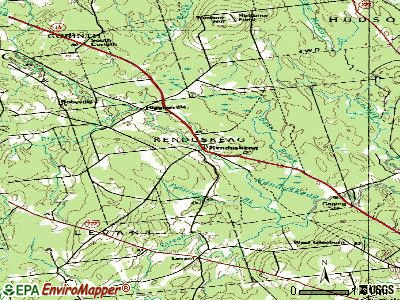
Points of interest:
Notable locations in Kenduskeag: Kenduskeag Fire Department (A), Case Memorial Library (B). Display/hide their locations on the map
Streams, rivers, and creeks: Baker Brook (A), Partridge Brook (B), Piper Brook (C). Display/hide their locations on the map
Drinking water stations with addresses in Kenduskeag and their reported violations in the past:
KENDUSKEAG GOLF & COUNTRY CLUB (Population served: 135, Groundwater):Past health violations:WOODED GROVE MOBILE HOME PARK (Population served: 90, Groundwater):Past monitoring violations:
- MCL, Monthly (TCR) - In FEB-2014, Contaminant: Coliform. Follow-up actions: St Public Notif requested (MAR-03-2014), St Formal NOV issued (MAR-03-2014), St Public Notif received (MAR-27-2014)
- MCL, Monthly (TCR) - In AUG-2011, Contaminant: Coliform. Follow-up actions: St Public Notif requested (AUG-22-2011), St Formal NOV issued (AUG-22-2011), St Public Notif received (SEP-01-2011), St Intentional no-action (SEP-17-2012)
- MCL, Monthly (TCR) - In JUL-2006, Contaminant: Coliform. Follow-up actions: St Public Notif requested (JUL-17-2006), St Violation/Reminder Notice (JUL-17-2006), St Public Notif received (2 times from JUL-26-2006 to JUL-26-2006), St Intentional no-action (SEP-09-2011), St Compliance achieved (SEP-09-2011)
- MCL, Monthly (TCR) - In JUN-2006, Contaminant: Coliform. Follow-up actions: St Violation/Reminder Notice (JUN-15-2006), St Public Notif requested (JUN-15-2006), St Public Notif received (2 times from JUL-16-2006 to JUL-16-2006), St Compliance achieved (SEP-08-2011), St Intentional no-action (SEP-09-2011)
- 4 routine major monitoring violations
- 2 regular monitoring violations
Past monitoring violations:
- Follow-up Or Routine LCR Tap M/R - In OCT-01-2008, Contaminant: Lead and Copper Rule. Follow-up actions: St Public Notif requested (NOV-18-2008), St Formal NOV issued (NOV-18-2008), St AO (w/penalty) issued (MAR-20-2009), St Public Notif received (APR-27-2009), St Compliance achieved (AUG-19-2009)
- Follow-up Or Routine LCR Tap M/R - In JAN-01-2008, Contaminant: Lead and Copper Rule. Follow-up actions: St Public Notif requested (JUL-23-2008), St Formal NOV issued (JUL-23-2008), St AO (w/penalty) issued (MAR-20-2009), St Public Notif received (APR-27-2009), St Compliance achieved (AUG-19-2009)
- Follow-up Or Routine LCR Tap M/R - In JAN-01-2007, Contaminant: Lead and Copper Rule. Follow-up actions: St Civil Case referred to AG (AUG-18-2006), St Public Notif requested (FEB-20-2007), St Violation/Reminder Notice (FEB-20-2007), St AO (w/penalty) issued (MAR-20-2009), St Public Notif received (APR-27-2009), St Compliance achieved (AUG-29-2011)
- 40 routine major monitoring violations
- 127 regular monitoring violations
| This town: | 2.4 people |
| Maine: | 2.3 people |
| This town: | 66.4% |
| Whole state: | 62.9% |
| This town: | 12.6% |
| Whole state: | 9.4% |
Likely homosexual households (counted as self-reported same-sex unmarried-partner households)
- Lesbian couples: 0.2% of all households
- Gay men: 0.5% of all households
| This town: | 8.9% |
| Whole state: | 10.9% |
| This town: | 1.9% |
| Whole state: | 4.1% |
For population 15 years and over in Kenduskeag:
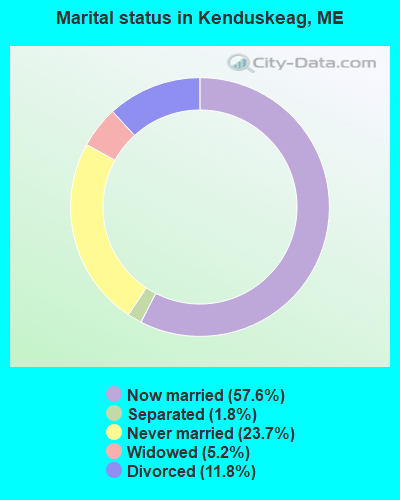
- Never married: 23.7%
- Now married: 57.6%
- Separated: 1.8%
- Widowed: 5.2%
- Divorced: 11.8%
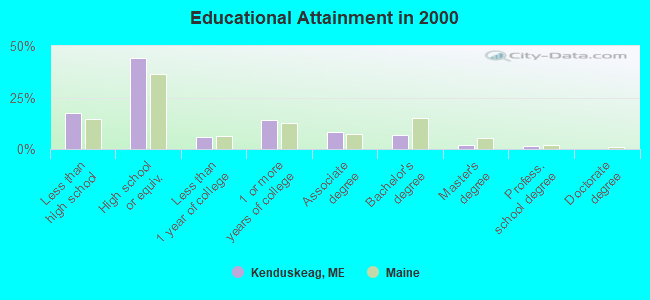
For population 25 years and over in Kenduskeag:
- High school or higher: 82.4%
- Bachelor's degree or higher: 10.0%
- Graduate or professional degree: 3.1%
- Unemployed: 7.2%
- Mean travel time to work (commute): 28.6 minutes
| Here: | 9.9 |
| Maine average: | 11.2 |


Graphs represent county-level data. Detailed 2008 Election Results
Religion statistics for Kenduskeag, ME (based on Penobscot County data)


| Religion | Adherents | Congregations |
|---|---|---|
| Catholic | 16,581 | 15 |
| Mainline Protestant | 9,715 | 59 |
| Evangelical Protestant | 7,523 | 80 |
| Other | 2,936 | 22 |
| Orthodox | 300 | 1 |
| None | 116,868 | - |
Food Environment Statistics:
| Penobscot County: | 2.29 / 10,000 pop. |
| Maine: | 2.80 / 10,000 pop. |
| Penobscot County: | 0.13 / 10,000 pop. |
| State: | 0.14 / 10,000 pop. |
| Penobscot County: | 2.56 / 10,000 pop. |
| Maine: | 2.20 / 10,000 pop. |
| This county: | 5.72 / 10,000 pop. |
| Maine: | 5.75 / 10,000 pop. |
| Penobscot County: | 7.41 / 10,000 pop. |
| State: | 11.02 / 10,000 pop. |
| This county: | 9.0% |
| State: | 8.2% |
| This county: | 28.0% |
| Maine: | 25.0% |
Strongest AM radio stations in Kenduskeag:
- WZON (620 AM; 5 kW; BANGOR, ME; Owner: THE ZONE CORPORATION)
- WABI (910 AM; 5 kW; BANGOR, ME; Owner: CLEAR CHANNEL BROADCASTING LICENSES, INC.)
- WSKW (1160 AM; 10 kW; SKOWHEGAN, ME; Owner: MOUNTAIN WIRELESS, INCORPORATED)
- WNZS (1340 AM; 1 kW; VEAZIE, ME; Owner: WATERFRONT COMMUNICATIONS INC.)
- WDEA (1370 AM; 5 kW; ELLSWORTH, ME; Owner: CUMULUS LICENSING CORP.)
- WTME (780 AM; 10 kW; RUMFORD, ME; Owner: MOUNTAIN VALLEY BROADCASTING, INC.)
- WRKO (680 AM; 50 kW; BOSTON, MA; Owner: ENTERCOM BOSTON LICENSE, LLC)
- WEEI (850 AM; 50 kW; BOSTON, MA; Owner: ENTERCOM BOSTON LICENSE, LLC)
- WBZ (1030 AM; 50 kW; BOSTON, MA; Owner: INFINITY BROADCASTING OPERATIONS, INC.)
- WCRN (830 AM; 50 kW; WORCESTER, MA; Owner: CARTER BROADCASTING CORPORATION)
- WNNZ (640 AM; 50 kW; WESTFIELD, MA; Owner: CLEAR CHANNEL BROADCASTING LICENSES, INC.)
- WFAU (1280 AM; 5 kW; GARDINER, ME; Owner: CAPSTAR TX LIMITED PARTNERSHIP)
- WCHP (760 AM; 35 kW; CHAMPLAIN, NY; Owner: CHAMPLAIN RADIO, INC.)
Strongest FM radio stations in Kenduskeag:
- WWBX (97.1 FM; BANGOR, ME; Owner: CLEAR CHANNEL BROADCASTING LICENSES, INC.)
- WQCB (106.5 FM; BREWER, ME; Owner: CUMULUS LICENSING CORP.)
- WBZN (107.3 FM; OLD TOWN, ME; Owner: CUMULUS LICENSING CORP.)
- WVOM (103.9 FM; HOWLAND, ME; Owner: CLEAR CHANNEL BROADCASTING LICENSES, INC.)
- WKIT-FM (100.3 FM; BREWER, ME; Owner: THE ZONE CORPORATION)
- WHCF (88.5 FM; BANGOR, ME; Owner: BANGOR BAPTIST CHURCH)
- WBFB (104.7 FM; BELFAST, ME; Owner: CLEAR CHANNEL BROADCASTING LICENSES, INC.)
- WWMJ (95.7 FM; ELLSWORTH, ME; Owner: CUMULUS LICENSING CORP.)
- WMEH (90.9 FM; BANGOR, ME; Owner: MAINE PUBLIC BROADCASTING CORPORATION)
- WGUY (102.1 FM; DEXTER, ME; Owner: CONCORD MEDIA GROUP, INC.)
- WEZQ (92.9 FM; BANGOR, ME; Owner: CUMULUS LICENSING CORP.)
- WFZX (101.7 FM; SEARSPORT, ME; Owner: CLEAR CHANNEL BROADCASTING LICENSES, INC.)
- WTOS-FM (105.1 FM; SKOWHEGAN, ME; Owner: CAPSTAR TX LIMITED PARTNERSHIP)
- WERU-FM (89.9 FM; BLUE HILL, ME; Owner: SALT POND COMMUNITY B/C COMPANY)
- WJCX (99.5 FM; PITTSFIELD, ME; Owner: CSN INTERNATIONAL)
- WMEB-FM (91.9 FM; ORONO, ME; Owner: UNIVERSITY OF MAINE SYSTEM)
- WDME-FM (103.1 FM; DOVER-FOXCROFT, ME; Owner: THE ZONE CORPORATION)
- WHSN (89.3 FM; BANGOR, ME; Owner: HUSSON COLLEGE)
- W275AE (102.9 FM; BANGOR, ME; Owner: SALT POND COMMUNITY BROADCASTING, INC.)
TV broadcast stations around Kenduskeag:
- WABI-TV (Channel 5; BANGOR, ME; Owner: COMMUNITY BROADCASTING SERVICE)
- W36CK (Channel 36; BANGOR, ME; Owner: TRINITY BROADCASTING NETWORK)
- WLBZ (Channel 2; BANGOR, ME; Owner: PACIFIC AND SOUTHERN COMPANY, INC.)
- WMEB-TV (Channel 12; ORONO, ME; Owner: MAINE PUBLIC BROADCASTING CORPORATION)
- WBGR-LP (Channel 33; BANGOR/DEDHAM, ME; Owner: MAINE FAMILY BROADCASTING, INC.)
- WCKD-LP (Channel 30; BANGOR/DEDHAM, ME; Owner: J. MCLEOD, ME FAMILY B/CING., INC.)
- W66CL (Channel 66; BANGOR, ME; Owner: MS COMMUNICATIONS, LLC)
- Kenduskeag, Maine
- Fatal accident count10
- Vehicles involved in fatal accidents15
- Fatal accidents involving drunk persons:6
- Fatalities10
- Persons involved in fatal accidents24
- Pedestrians involved in fatal accidents1
- Maine average
- Fatal accident count1755
- Vehicles involved in fatal accidents2478
- Fatal accidents involving drunk persons719
- Fatalities1955
- Persons involved in fatal accidents4192
- Pedestrians involved in fatal accidents105
- National Bridge Inventory (NBI) Statistics
- 3Number of bridges
- 39ft / 12.1mTotal length
- 10,535Total average daily traffic
- 526Total average daily truck traffic
- 14,827Total future (year 2036) average daily traffic
FCC Registered Antenna Towers:
7- Steven N Mejia, 701 Stetson Road (Lat: 44.917778 Lon: -68.949167), Type: 60.4, Overall height: 57.9 m, Phone: (732) 744-0652
- Steven N Mejia, 701 Stetson Road (Lat: 44.917778 Lon: -68.949167), Type: 60.4, Overall height: 57.9 m, Phone: (732) 744-0652
- Steven N Mejia, 701 Stetson Road (Lat: 44.917778 Lon: -68.949167), Type: 60.4, Overall height: 57.9 m, Phone: (732) 744-0652
- Steven N Mejia, 701 Stetson Road (Lat: 44.917778 Lon: -68.949167), Type: 60.4, Overall height: 57.9 m, Registrant: Clearview Tower Company, LLC, Fishe-r Island, Phone: (732) 744-0652
- Steven N Mejia, 701 Stetson Road (Lat: 44.917778 Lon: -68.949167), Type: 60.4, Overall height: 57.9 m, Registrant: Clearview Tower Company, LLC, Ediso-n, Phone: (732) 744-0652
- F. Howard Mandel, 701 Stetson Road (Lat: 44.917778 Lon: -68.949167), Type: 60.4, Structure height: 23019 m, Overall height: 57.9 m, Registrant: K2 Towers, LLC, Hmandel@peppertreecapital.Com, , Chagr-in Falls, Phone: (866) 962-0904
- Jake T Chapman, 701 Stetson Road (Lat: 44.917778 Lon: -68.949167), Type: 60.4, Structure height: 23019 m, Overall height: 57.9 m, Registrant: American Towers, LLC, Faa-Fcc@americantower.Com, , Wobur-n, Phone: (781) 926-4500
FCC Registered Broadcast Land Mobile Towers:
2- 4012 Broadway (Lat: 44.921722 Lon: -68.932806), Type: Bant, Structure height: 39 m, Call Sign: KNDR606,
Assigned Frequencies: 154.310 MHz, 154.325 MHz, Grant Date: 10/25/2022, Expiration Date: 10/01/2032, Registrant: Kenduskeag, Town Of, Kenduskeag, ME 04450, Phone: (207) 884-7947
- 103 Joan S Hill Rd (Lat: 44.858167 Lon: -68.730750), Call Sign: WQYT964,
Assigned Frequencies: 159.840 MHz, 159.840 MHz, Grant Date: 01/19/2017, Expiration Date: 01/19/2027, Certifier: Alex Demers, Registrant: Jp2way, 1201 S 3rd St, Paducah, KY 42003, Phone: (270) 443-6618, Fax: (270) 443-6402, Email:
FCC Registered Microwave Towers:
1- Kenduskeag, 701 Stetson Road (Lat: 44.917778 Lon: -68.949167), Type: Pole, Structure height: 57.9 m, Overall height: 60.4 m, Call Sign: WQHT232,
Assigned Frequencies: 10623.1 MHz, Grant Date: 10/30/2007, Expiration Date: 10/30/2017, Cancellation Date: 07/06/2015, Certifier: John T Scott Iii, Registrant: Verizon Wireless, 1120 Sanctuary Pkwy, #150 Gasa5reg, Alpharetta, GA 30009-7630, Phone: (770) 797-1070, Fax: (770) 797-1036, Email:
FCC Registered Amateur Radio Licenses:
16 (See the full list of FCC Registered Amateur Radio Licenses in Kenduskeag)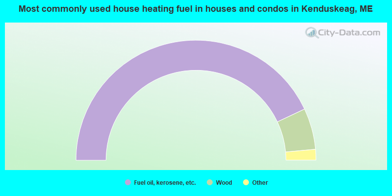
- 86.0%Fuel oil, kerosene, etc.
- 11.1%Wood
- 2.4%Bottled, tank, or LP gas
- 0.5%Electricity
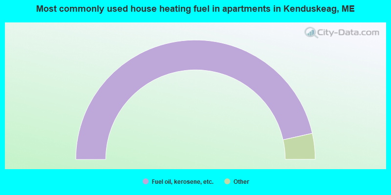
- 93.0%Fuel oil, kerosene, etc.
- 3.5%Bottled, tank, or LP gas
- 3.5%Wood
Kenduskeag compared to Maine state average:
- Median house value below state average.
- Unemployed percentage below state average.
- Black race population percentage significantly below state average.
- Hispanic race population percentage below state average.
- Foreign-born population percentage significantly below state average.
- Renting percentage below state average.
- Length of stay since moving in significantly above state average.
- Number of rooms per house significantly below state average.
- House age significantly below state average.
- Percentage of population with a bachelor's degree or higher significantly below state average.