Hermon, Maine
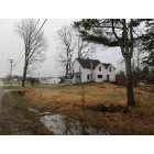
Submit your own pictures of this town and show them to the world
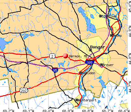
- OSM Map
- General Map
- Google Map
- MSN Map
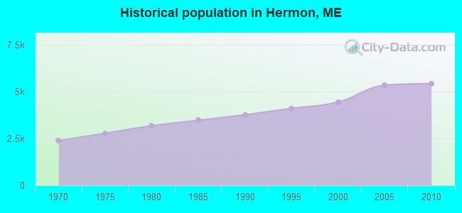
Population change since 2000: +22.1%
| Males: 2,668 | |
| Females: 2,748 |
| Median resident age: | 40.4 years |
| Maine median age: | 43.0 years |
Zip codes: 04401.
| Hermon: | $84,201 |
| ME: | $69,543 |
Estimated per capita income in 2022: $39,631 (it was $19,714 in 2000)
Hermon town income, earnings, and wages data
Estimated median house or condo value in 2022: $248,237 (it was $95,400 in 2000)
| Hermon: | $248,237 |
| ME: | $290,600 |
Mean prices in 2022: all housing units: $235,563; detached houses: $252,705; townhouses or other attached units: $267,749; in 2-unit structures: $255,332; in 3-to-4-unit structures: $815,300; in 5-or-more-unit structures: $185,873; mobile homes: $93,017; occupied boats, rvs, vans, etc.: $21,333
Detailed information about poverty and poor residents in Hermon, ME

Compare current foreclosures near Hermon, ME:
| Photo | Address | Area | Beds / Baths | Price | Details |
|---|---|---|---|---|---|

|
#1
Smokey Ln
Bangor, ME 04401
|
2,434 sq. feet
|
2 baths 3 beds |
show details | |

|
#2
Ichabod Ln
Hampden, ME 04444
|
960 sq. feet
|
1 baths 3 beds |
show details | |

|
#3
Main St
Corinth, ME 04427
|
1,573 sq. feet
|
2 baths 3 beds |
show details | |

|
#4
Rd
Brewer, ME 04412
|
2,428 sq. feet
|
1 baths 4 beds |
show details | |

|
#5
Kenduskeag Levant Rd
Kenduskeag, ME 04450
|
- sq. feet
|
2 baths 3 beds |
show details | |

|
#6
Upper Cross Rd
Hudson, ME 04449
|
1,344 sq. feet
|
2 baths 3 beds |
show details | |

|
#7
Western Ave
Hampden, ME 04444
|
1,976 sq. feet
|
2 baths 4 beds |
show details | |

|
#8
Western Ave
Hampden, ME 04444
|
1,825 sq. feet
|
1 baths 3 beds |
show details | |

|
#9
Maxwell Ln
Bangor, ME 04401
|
1,750 sq. feet
|
2 baths 3 beds |
show details | |

|
#10
Allen St
Bangor, ME 04401
|
1,200 sq. feet
|
1 baths 3 beds |
show details |
| Photo | Address | Area | Beds / Baths | Price | Details |
|---|---|---|---|---|---|

|
#11
Lancaster Ave
Bangor, ME 04401
|
324 sq. feet
|
1 baths 1 beds |
show details | |

|
#12
Grove St
Bangor, ME 04401
|
910 sq. feet
|
1 baths 3 beds |
show details | |

|
#13
Bennoch Rd
Old Town, ME 04468
|
- sq. feet
|
- baths - beds |
show details | |

|
#14
Summer St
Old Town, ME 04468
|
- sq. feet
|
- baths - beds |
show details | |

|
#15
Morison Ave
Corinth, ME 04427
|
- sq. feet
|
- baths - beds |
show details | |

|
#16
Wolfboro Rd
Stetson, ME 04488
|
- sq. feet
|
- baths - beds |
show details | |

|
#17
Exeter Rd
Corinth, ME 04427
|
- sq. feet
|
- baths - beds |
show details | |

|
#18
Pine St # B
Bangor, ME 04401
|
- sq. feet
|
- baths - beds |
show details | |

|
#19
Broadway
Kenduskeag, ME 04450
|
- sq. feet
|
- baths - beds |
show details | |

|
#20
Baker Blvd Ste 205
Brewer, ME 04412
|
- sq. feet
|
- baths - beds |
show details |
| Photo | Address | Area | Beds / Baths | Price | Details |
|---|---|---|---|---|---|

|
#21
Indian Hill Ln
Frankfort, ME 04438
|
- sq. feet
|
- baths - beds |
show details | |

|
#22
Pleasant Hill Ln
Orrington, ME 04474
|
- sq. feet
|
- baths - beds |
show details | |

|
#23
Cedar St Apt 4
Bangor, ME 04401
|
- sq. feet
|
- baths - beds |
show details | |

|
#24
Call Rd # D
Milford, ME 04461
|
- sq. feet
|
- baths - beds |
show details | |

|
#25
Hampden Rd
Carmel, ME 04419
|
- sq. feet
|
- baths - beds |
show details | |

|
#26
Harris Rd Apt 31
Orono, ME 04473
|
- sq. feet
|
- baths - beds |
show details | |

|
#27
Merrill Rd
Eddington, ME 04428
|
- sq. feet
|
- baths - beds |
show details | |

|
#28
Central St
Bucksport, ME 04416
|
- sq. feet
|
- baths - beds |
show details | |

|
#29
South Rd
Brewer, ME 04412
|
- sq. feet
|
- baths - beds |
show details | |

|
#30
W Old Town Rd
Old Town, ME 04468
|
- sq. feet
|
- baths - beds |
show details |
| Photo | Address | Area | Beds / Baths | Price | Details |
|---|---|---|---|---|---|

|
#31
Hudson Hill Rd
Hudson, ME 04449
|
- sq. feet
|
- baths - beds |
show details | |

|
#32
Hudson Rd
Hudson, ME 04449
|
- sq. feet
|
- baths - beds |
show details | |

|
#33
Cedar Breeze N
Bangor, ME 04401
|
- sq. feet
|
- baths - beds |
show details | |

|
#34
S Road
Brewer, ME 04412
|
- sq. feet
|
- baths - beds |
show details | |
|
|
#35
York Rd
Bangor, ME 04401
|
- sq. feet
|
- baths - beds |
show details | |

|
#36
Aa Landing Rd
Bangor, ME 04401
|
- sq. feet
|
- baths - beds |
show details | |

|
#37
Kenduskeag Ave # 24
Bangor, ME 04401
|
- sq. feet
|
- baths - beds |
show details | |

|
#38
Hinks St
Bucksport, ME 04416
|
- sq. feet
|
- baths - beds |
show details | |

|
Check over 1 million property listings on Foreclosure.com!
|
browse all offers | |||

- 5,24796.9%White alone
- 531.0%Hispanic
- 500.9%Two or more races
- 220.4%Black alone
- 190.4%American Indian alone
- 220.4%Asian alone
- 20.04%Other race alone
- 10.02%Native Hawaiian and Other
Pacific Islander alone
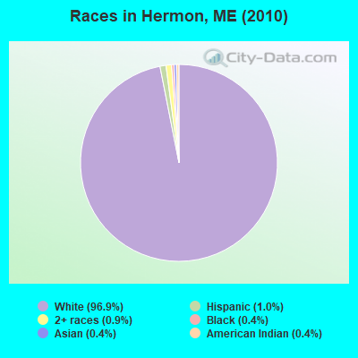
Races in Hermon detailed stats: ancestries, foreign born residents, place of birth
According to our research of Maine and other state lists, there were 5 registered sex offenders living in Hermon, Maine as of April 29, 2024.
The ratio of all residents to sex offenders in Hermon is 1,083 to 1.
The ratio of registered sex offenders to all residents in this city is lower than the state average.
 Recent articles from our blog. Our writers, many of them Ph.D. graduates or candidates, create easy-to-read articles on a wide variety of topics.

 | Potential Move to Bangor (14 replies) |
| Looking to move outside Bangor with kids (6 replies) |
| Where to live? (21 replies) |
| Possible move to Maine with young kids, Scottish husband. (26 replies) |
| Best place to live within 50 miles of Ellsworth (11 replies) |
| Choice between Bangor and Rockland (13 replies) |
Latest news from Hermon, ME collected exclusively by city-data.com from local newspapers, TV, and radio stations
Ancestries: United States (16.3%), English (14.0%), Irish (13.7%), French (11.6%), German (5.5%), French Canadian (5.4%).
Current Local Time: EST time zone
Incorporated on 06/13/1814
Elevation: 178 feet
Land area: 35.9 square miles.
Population density: 151 people per square mile (very low).
53 residents are foreign born
| This town: | 1.2% |
| Maine: | 2.9% |
| Hermon town: | 1.3% ($1,213) |
| Maine: | 1.5% ($1,417) |
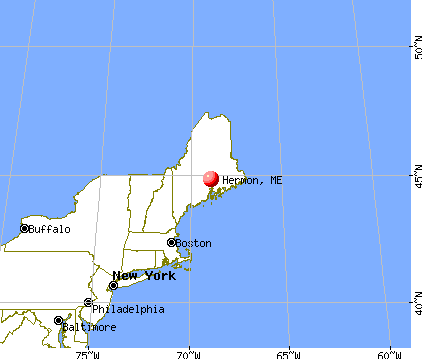
Nearest city with pop. 50,000+: Portland, ME  (103.5 miles , pop. 64,249).
Nearest city with pop. 200,000+: Boston, MA (203.3 miles , pop. 589,141).
Nearest city with pop. 1,000,000+: Bronx, NY (371.6 miles , pop. 1,332,650).
Nearest cities:
), ), ), ), ), )Latitude: 44.80 N, Longitude: 68.91 W
Area code: 207

Single-family new house construction building permits:
- 2022: 34 buildings, average cost: $279,100
- 2021: 37 buildings, average cost: $285,000
- 2020: 40 buildings, average cost: $265,000
- 2019: 30 buildings, average cost: $281,600
- 2018: 38 buildings, average cost: $276,200
- 2017: 35 buildings, average cost: $229,100
- 2016: 33 buildings, average cost: $256,000
- 2015: 38 buildings, average cost: $232,200
- 2014: 38 buildings, average cost: $220,800
- 2013: 36 buildings, average cost: $202,800
- 2012: 31 buildings, average cost: $182,400
- 2011: 46 buildings, average cost: $189,100
- 2010: 34 buildings, average cost: $169,400
- 2009: 37 buildings, average cost: $151,700
- 2008: 18 buildings, average cost: $172,000
- 2007: 34 buildings, average cost: $186,000
- 2006: 46 buildings, average cost: $174,600
- 2005: 112 buildings, average cost: $146,800
- 2004: 57 buildings, average cost: $147,700
- 2003: 54 buildings, average cost: $123,400
- 2002: 52 buildings, average cost: $112,700
- 2001: 40 buildings, average cost: $93,000
- 2000: 36 buildings, average cost: $90,000
- 1999: 43 buildings, average cost: $114,500
- 1998: 41 buildings, average cost: $87,000
- 1997: 22 buildings, average cost: $94,000
| Here: | 3.0% |
| Maine: | 3.4% |
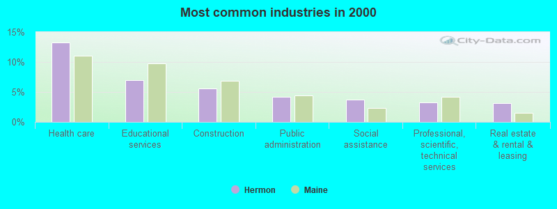
- Health care (13.3%)
- Educational services (6.9%)
- Construction (5.6%)
- Public administration (4.2%)
- Social assistance (3.7%)
- Professional, scientific, technical services (3.2%)
- Real estate & rental & leasing (3.2%)
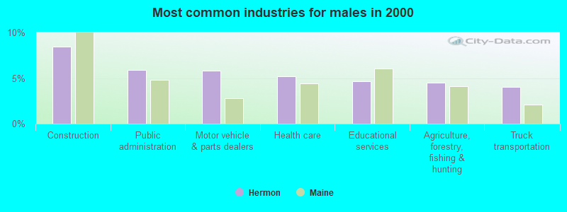
- Construction (8.4%)
- Public administration (5.9%)
- Motor vehicle & parts dealers (5.8%)
- Health care (5.2%)
- Educational services (4.6%)
- Agriculture, forestry, fishing & hunting (4.5%)
- Truck transportation (4.0%)
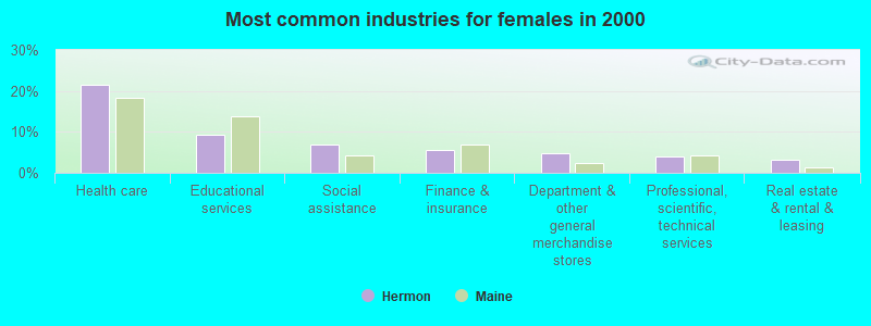
- Health care (21.6%)
- Educational services (9.3%)
- Social assistance (7.0%)
- Finance & insurance (5.6%)
- Department & other general merchandise stores (4.9%)
- Professional, scientific, technical services (4.0%)
- Real estate & rental & leasing (3.1%)
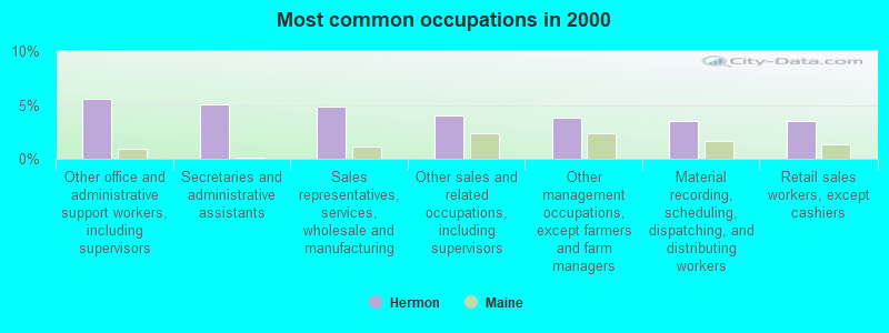
- Other office and administrative support workers, including supervisors (5.6%)
- Secretaries and administrative assistants (5.0%)
- Sales representatives, services, wholesale and manufacturing (4.9%)
- Other sales and related occupations, including supervisors (4.0%)
- Other management occupations, except farmers and farm managers (3.8%)
- Material recording, scheduling, dispatching, and distributing workers (3.6%)
- Retail sales workers, except cashiers (3.5%)
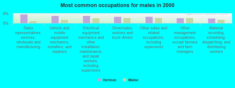
- Sales representatives, services, wholesale and manufacturing (7.5%)
- Vehicle and mobile equipment mechanics, installers, and repairers (6.4%)
- Electrical equipment mechanics and other installation, maintenance, and repair workers, including supervisors (6.3%)
- Driver/sales workers and truck drivers (5.7%)
- Other sales and related occupations, including supervisors (5.6%)
- Other management occupations, except farmers and farm managers (4.3%)
- Material recording, scheduling, dispatching, and distributing workers (4.0%)
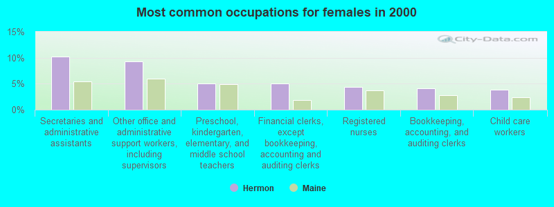
- Secretaries and administrative assistants (10.2%)
- Other office and administrative support workers, including supervisors (9.2%)
- Preschool, kindergarten, elementary, and middle school teachers (5.1%)
- Financial clerks, except bookkeeping, accounting and auditing clerks (5.1%)
- Registered nurses (4.4%)
- Bookkeeping, accounting, and auditing clerks (4.1%)
- Child care workers (3.9%)
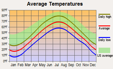
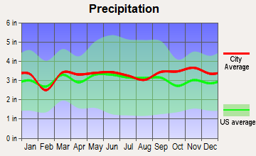
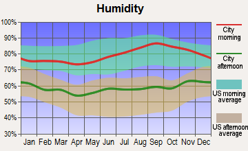
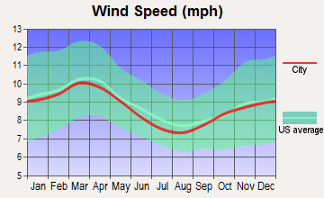
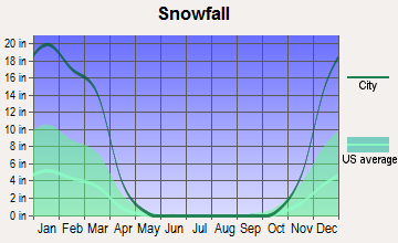
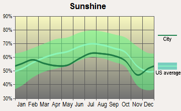
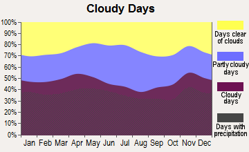
Average climate in Hermon, Maine
Based on data reported by over 4,000 weather stations
(lower is better)
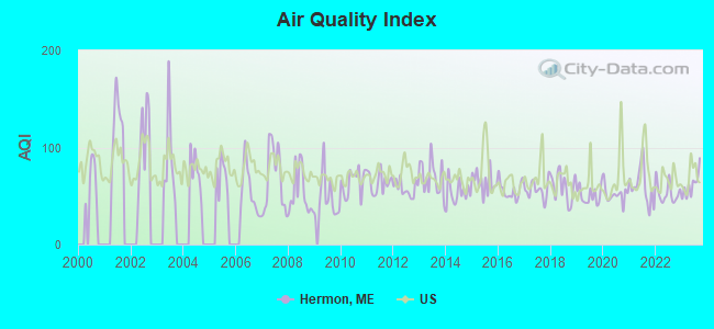
Air Quality Index (AQI) level in 2023 was 61.1. This is about average.
| City: | 61.1 |
| U.S.: | 72.6 |
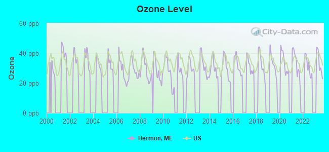
Ozone [ppb] level in 2023 was 33.6. This is about average. Closest monitor was 5.9 miles away from the city center.
| City: | 33.6 |
| U.S.: | 33.3 |
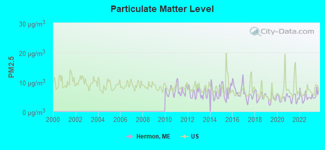
Particulate Matter (PM2.5) [µg/m3] level in 2023 was 5.62. This is significantly better than average. Closest monitor was 6.9 miles away from the city center.
| City: | 5.62 |
| U.S.: | 8.11 |
Earthquake activity:
Hermon-area historical earthquake activity is significantly above Maine state average. It is 81% smaller than the overall U.S. average.On 4/20/2002 at 10:50:47, a magnitude 5.3 (5.3 ML, Depth: 3.0 mi, Class: Moderate, Intensity: VI - VII) earthquake occurred 236.3 miles away from the city center
On 10/16/2012 at 23:12:25, a magnitude 4.7 (4.7 ML, Depth: 10.0 mi, Class: Light, Intensity: IV - V) earthquake occurred 120.1 miles away from the city center
On 4/20/2002 at 10:50:47, a magnitude 5.2 (5.2 MB, 4.2 MS, 5.2 MW, 5.0 MW) earthquake occurred 237.5 miles away from Hermon center
On 10/7/1983 at 10:18:46, a magnitude 5.3 (5.1 MB, 5.3 LG, 5.1 ML) earthquake occurred 274.8 miles away from Hermon center
On 1/19/1982 at 00:14:42, a magnitude 4.7 (4.5 MB, 4.7 MD, 4.5 LG) earthquake occurred 160.9 miles away from Hermon center
On 2/26/1999 at 03:38:43, a magnitude 3.8 (3.8 LG, Depth: 2.0 mi, Class: Light, Intensity: II - III) earthquake occurred 37.3 miles away from Hermon center
Magnitude types: regional Lg-wave magnitude (LG), body-wave magnitude (MB), duration magnitude (MD), local magnitude (ML), surface-wave magnitude (MS), moment magnitude (MW)
Natural disasters:
The number of natural disasters in Penobscot County (19) is greater than the US average (15).Major Disasters (Presidential) Declared: 11
Emergencies Declared: 7
Causes of natural disasters: Floods: 9, Storms: 8, Snows: 5, Heavy Rains: 2, Blizzard: 1, Hurricane: 1, Ice Storm: 1, Snowfall: 1, Wind: 1, Winter Storm: 1, Other: 2 (Note: some incidents may be assigned to more than one category).
Hospitals and medical centers near Hermon:
- BANGOR AREA VISITING NURSES (Home Health Center, about 6 miles away; BANGOR, ME)
- HOSPICE OF EASTERN MAINE (Hospital, about 6 miles away; BANGOR, ME)
- BANGOR NURSING AND REHABILITATION (Nursing Home, about 6 miles away; BANGOR, ME)
- KINDRED NURSING AND REHABILITATION-WESTGATE (Nursing Home, about 6 miles away; BANGOR, ME)
- ST JOSEPH HOSPICE (Hospital, about 6 miles away; BANGOR, ME)
- ST JOSEPH HOSPITAL Acute Care Hospitals (about 6 miles away; BANGOR, ME)
- AMEDISYS HOME HEALTH OF BANGOR (Home Health Center, about 7 miles away; BANGOR, ME)
Colleges/universities with over 2000 students nearest to Hermon:
- Husson University (about 7 miles; Bangor, ME; Full-time enrollment: 2,421)
- University of Maine (about 14 miles; Orono, ME; FT enrollment: 8,931)
- University of Maine at Augusta (about 55 miles; Augusta, ME; FT enrollment: 3,204)
- University of Maine at Farmington (about 62 miles; Farmington, ME; FT enrollment: 2,036)
- Saint Joseph's College of Maine (about 103 miles; Standish, ME; FT enrollment: 2,010)
- Southern Maine Community College (about 104 miles; South Portland, ME; FT enrollment: 4,666)
- University of Southern Maine (about 104 miles; Portland, ME; FT enrollment: 6,647)
Public high school in Hermon:
- HERMON HIGH SCHOOL (Location: 2415 ROUTE 2, Grades: 9-12)
Public elementary/middle schools in Hermon:
- HERMON ELEMENTARY SCHOOL (Location: 235 BILLINGS ROAD, Grades: PK-4)
- HERMON MIDDLE SCHOOL (Location: 29 BILLINGS ROAD, Grades: 5-8)
Private elementary/middle school in Hermon:
Points of interest:
Notable locations in Hermon: Wheeler Stream Camping Area (A), Pleasant Hill Campground (B), Hermon Meadows Golf Club (C), Herman Meadows Golf and Ski Center (D), Freedom Industrial Park (E), Hermon Volunteer Rescue Ambulance (F), Hermon Fire Department (G). Display/hide their locations on the map
Church in Hermon: Hermon Baptist Church (A). Display/hide its location on the map
Cemeteries: Hermon Pond Cemetery (1), Pleasant Hill Cemetery (2), Pine Tree Cemetery (3), Evergreen Cemetery (4). Display/hide their locations on the map
Lakes and swamps: Tracy Pond (A), George Pond (B), Hermon Pond (C), Pug Pond (D), Hermon Bog (E). Display/hide their locations on the map
Streams, rivers, and creeks: Wheeler Stream (A), Patten Stream (B), Black Stream (C), Pug Brook (D). Display/hide their locations on the map
Park in Hermon: Hermon Creative Playground (1). Display/hide its location on the map
Drinking water stations with addresses in Hermon and their reported violations in the past:
HERMON HIGH SCHOOL (Population served: 550, Groundwater):Past health violations:HERMON ELEM SCHOOL (Population served: 375, Groundwater):Past monitoring violations:
- MCL, Monthly (TCR) - In FEB-2007, Contaminant: Coliform. Follow-up actions: St Violation/Reminder Notice (FEB-20-2007), St Public Notif requested (FEB-20-2007), St Public Notif received (FEB-28-2007), St Compliance achieved (MAY-11-2011)
- Follow-up Or Routine LCR Tap M/R - In JAN-11-2006, Contaminant: Lead and Copper Rule. Follow-up actions: St Public Notif requested (JAN-11-2006), St Violation/Reminder Notice (JAN-11-2006), St Public Notif received (MAY-02-2006), St Compliance achieved (JUL-07-2006)
- 2 routine major monitoring violations
Past monitoring violations:HERMON MIDDLE SCHOOL #2 (Population served: 327, Groundwater):
- Follow-up Or Routine LCR Tap M/R - In JAN-11-2006, Contaminant: Lead and Copper Rule. Follow-up actions: St Public Notif requested (JAN-11-2006), St Violation/Reminder Notice (JAN-11-2006), St Public Notif received (MAY-02-2006), St Compliance achieved (JUL-07-2006)
- 6 routine major monitoring violations
Past health violations:PLEASANT HILL CAMPGROUND (Population served: 263, Groundwater):Past monitoring violations:
- MCL, Monthly (TCR) - In NOV-2008, Contaminant: Coliform. Follow-up actions: St Public Notif requested (DEC-01-2008), St Formal NOV issued (DEC-01-2008), St Public Notif received (FEB-17-2009), St Compliance achieved (APR-29-2009)
- MCL, Monthly (TCR) - In OCT-2008, Contaminant: Coliform. Follow-up actions: St Public Notif requested (NOV-03-2008), St Formal NOV issued (NOV-03-2008), St Public Notif received (FEB-17-2009), St Compliance achieved (APR-29-2009)
- MCL, Monthly (TCR) - In SEP-2008, Contaminant: Coliform. Follow-up actions: St Public Notif requested (SEP-22-2008), St Formal NOV issued (SEP-22-2008), St Compliance achieved (APR-29-2009), St Intentional no-action (SEP-15-2011)
- MCL, Monthly (TCR) - In APR-2008, Contaminant: Coliform. Follow-up actions: St Public Notif requested (MAY-08-2008), St Formal NOV issued (MAY-08-2008), St Public Notif received (JUN-10-2008), St Compliance achieved (APR-29-2009)
- MCL, Monthly (TCR) - In NOV-2007, Contaminant: Coliform. Follow-up actions: St Public Notif requested (NOV-16-2007), St Formal NOV issued (NOV-16-2007), St Public Notif received (NOV-30-2007), St Compliance achieved (APR-29-2009)
- Follow-up Or Routine LCR Tap M/R - In JAN-11-2006, Contaminant: Lead and Copper Rule. Follow-up actions: St Public Notif requested (JAN-11-2006), St Violation/Reminder Notice (JAN-11-2006), St Public Notif received (MAY-02-2006), St Compliance achieved (OCT-02-2006)
- 3 routine major monitoring violations
- One minor monitoring violation
- 4 regular monitoring violations
Past monitoring violations:HERMON FAMILY RESTAURANT (Population served: 250, Groundwater):
- 2 regular monitoring violations
Past health violations:HERMON MEADOWS GOLF COURSE (Population served: 160, Groundwater):Past monitoring violations:
- MCL, Monthly (TCR) - In OCT-2005, Contaminant: Coliform. Follow-up actions: St Public Notif requested (OCT-18-2005), St Violation/Reminder Notice (OCT-18-2005), St Compliance achieved (JAN-11-2008), St Intentional no-action (AUG-14-2011)
- MCL, Monthly (TCR) - In JUL-2005, Contaminant: Coliform. Follow-up actions: St Public Notif requested (AUG-02-2005), St Violation/Reminder Notice (AUG-02-2005), St Compliance achieved (JAN-11-2008), St Intentional no-action (AUG-14-2011)
- One routine major monitoring violation
- 5 regular monitoring violations
Past health violations:PUMPKIN PATCH RV RESORT (Population served: 150, Groundwater):Past monitoring violations:
- MCL, Monthly (TCR) - In NOV-2011, Contaminant: Coliform. Follow-up actions: St Public Notif requested (NOV-14-2011), St Formal NOV issued (NOV-14-2011), St Public Notif received (NOV-26-2011), St Compliance achieved (MAY-23-2012)
- 2 routine major monitoring violations
Past health violations:HINGHAM HEIGHTS (Population served: 140, Groundwater):Past monitoring violations:
- MCL, Monthly (TCR) - In JUN-2010, Contaminant: Coliform. Follow-up actions: St Public Notif requested (JUN-10-2010), St Formal NOV issued (JUN-10-2010), St Compliance achieved (JUN-10-2010), St Public Notif received (MAY-17-2012)
- MCL, Monthly (TCR) - In MAY-2010, Contaminant: Coliform. Follow-up actions: St Public Notif requested (MAY-20-2010), St Formal NOV issued (MAY-20-2010), St Public Notif received (MAY-26-2010), St Compliance achieved (JUN-10-2010)
- 2 routine major monitoring violations
- One regular monitoring violation
Past monitoring violations:
- Follow-up Or Routine LCR Tap M/R - In OCT-01-2013, Contaminant: Lead and Copper Rule. Follow-up actions: St Public Notif requested (NOV-13-2013), St Formal NOV issued (NOV-13-2013), St Public Notif received (MAR-25-2014)
- Follow-up Or Routine LCR Tap M/R - In OCT-01-2006, Contaminant: Lead and Copper Rule. Follow-up actions: St Public Notif requested (FEB-20-2007), St Violation/Reminder Notice (FEB-20-2007), St Public Notif received (JAN-03-2008), St Compliance achieved (JAN-08-2008)
- Follow-up Or Routine LCR Tap M/R - In JAN-11-2006, Contaminant: Lead and Copper Rule. Follow-up actions: St Public Notif requested (JAN-11-2006), St Violation/Reminder Notice (JAN-11-2006), St Public Notif received (JUL-05-2006), St Compliance achieved (SEP-23-2008)
- 2 routine major monitoring violations
- 4 regular monitoring violations
| This town: | 2.6 people |
| Maine: | 2.3 people |
| This town: | 74.6% |
| Whole state: | 62.9% |
| This town: | 8.7% |
| Whole state: | 9.4% |
Likely homosexual households (counted as self-reported same-sex unmarried-partner households)
- Lesbian couples: 0.6% of all households
- Gay men: 0.3% of all households
| This town: | 6.6% |
| Whole state: | 10.9% |
| This town: | 3.1% |
| Whole state: | 4.1% |
3 people in homes for the mentally retarded in 2000
Banks with branches in Hermon (2011 data):
- The Camden National Bank: Hermon Branch at 2530 Us Route 2, branch established on 1990/03/05. Info updated 2008/02/27: Bank assets: $2,266.8 mil, Deposits: $1,604.6 mil, headquarters in Camden, ME, positive income, Commercial Lending Specialization, 39 total offices, Holding Company: Camden National Corporation
For population 15 years and over in Hermon:
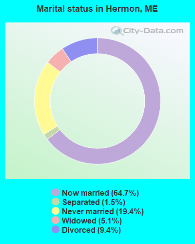
- Never married: 19.4%
- Now married: 64.7%
- Separated: 1.5%
- Widowed: 5.1%
- Divorced: 9.4%
For population 25 years and over in Hermon:
- High school or higher: 90.8%
- Bachelor's degree or higher: 19.4%
- Graduate or professional degree: 6.7%
- Unemployed: 4.1%
- Mean travel time to work (commute): 20.7 minutes
| Here: | 9.3 |
| Maine average: | 11.2 |


Graphs represent county-level data. Detailed 2008 Election Results
Religion statistics for Hermon, ME (based on Penobscot County data)


| Religion | Adherents | Congregations |
|---|---|---|
| Catholic | 16,581 | 15 |
| Mainline Protestant | 9,715 | 59 |
| Evangelical Protestant | 7,523 | 80 |
| Other | 2,936 | 22 |
| Orthodox | 300 | 1 |
| None | 116,868 | - |
Food Environment Statistics:
| Penobscot County: | 2.29 / 10,000 pop. |
| State: | 2.80 / 10,000 pop. |
| Penobscot County: | 0.13 / 10,000 pop. |
| Maine: | 0.14 / 10,000 pop. |
| This county: | 2.56 / 10,000 pop. |
| Maine: | 2.20 / 10,000 pop. |
| Here: | 5.72 / 10,000 pop. |
| Maine: | 5.75 / 10,000 pop. |
| Penobscot County: | 7.41 / 10,000 pop. |
| Maine: | 11.02 / 10,000 pop. |
| This county: | 9.0% |
| Maine: | 8.2% |
| Here: | 28.0% |
| State: | 25.0% |
| Businesses in Hermon, ME | ||||
| Name | Count | Name | Count | |
|---|---|---|---|---|
| Dunkin Donuts | 1 | True Value | 1 | |
| Ryder Rental & Truck Leasing | 1 | UPS | 1 | |
| Subway | 1 | |||
Strongest AM radio stations in Hermon:
- WZON (620 AM; 5 kW; BANGOR, ME; Owner: THE ZONE CORPORATION)
- WABI (910 AM; 5 kW; BANGOR, ME; Owner: CLEAR CHANNEL BROADCASTING LICENSES, INC.)
- WSKW (1160 AM; 10 kW; SKOWHEGAN, ME; Owner: MOUNTAIN WIRELESS, INCORPORATED)
- WNZS (1340 AM; 1 kW; VEAZIE, ME; Owner: WATERFRONT COMMUNICATIONS INC.)
- WDEA (1370 AM; 5 kW; ELLSWORTH, ME; Owner: CUMULUS LICENSING CORP.)
- WTME (780 AM; 10 kW; RUMFORD, ME; Owner: MOUNTAIN VALLEY BROADCASTING, INC.)
- WRKO (680 AM; 50 kW; BOSTON, MA; Owner: ENTERCOM BOSTON LICENSE, LLC)
- WEEI (850 AM; 50 kW; BOSTON, MA; Owner: ENTERCOM BOSTON LICENSE, LLC)
- WBZ (1030 AM; 50 kW; BOSTON, MA; Owner: INFINITY BROADCASTING OPERATIONS, INC.)
- WFAU (1280 AM; 5 kW; GARDINER, ME; Owner: CAPSTAR TX LIMITED PARTNERSHIP)
- WCRN (830 AM; 50 kW; WORCESTER, MA; Owner: CARTER BROADCASTING CORPORATION)
- WNNZ (640 AM; 50 kW; WESTFIELD, MA; Owner: CLEAR CHANNEL BROADCASTING LICENSES, INC.)
- WMTW (870 AM; 10 kW; GORHAM, ME; Owner: RADIO PARTNERS OF MAINE, L.P.)
Strongest FM radio stations in Hermon:
- WWBX (97.1 FM; BANGOR, ME; Owner: CLEAR CHANNEL BROADCASTING LICENSES, INC.)
- WKIT-FM (100.3 FM; BREWER, ME; Owner: THE ZONE CORPORATION)
- WBFB (104.7 FM; BELFAST, ME; Owner: CLEAR CHANNEL BROADCASTING LICENSES, INC.)
- WWMJ (95.7 FM; ELLSWORTH, ME; Owner: CUMULUS LICENSING CORP.)
- WMEH (90.9 FM; BANGOR, ME; Owner: MAINE PUBLIC BROADCASTING CORPORATION)
- WEZQ (92.9 FM; BANGOR, ME; Owner: CUMULUS LICENSING CORP.)
- WQCB (106.5 FM; BREWER, ME; Owner: CUMULUS LICENSING CORP.)
- WVOM (103.9 FM; HOWLAND, ME; Owner: CLEAR CHANNEL BROADCASTING LICENSES, INC.)
- WHCF (88.5 FM; BANGOR, ME; Owner: BANGOR BAPTIST CHURCH)
- WBZN (107.3 FM; OLD TOWN, ME; Owner: CUMULUS LICENSING CORP.)
- WFZX (101.7 FM; SEARSPORT, ME; Owner: CLEAR CHANNEL BROADCASTING LICENSES, INC.)
- WGUY (102.1 FM; DEXTER, ME; Owner: CONCORD MEDIA GROUP, INC.)
- WERU-FM (89.9 FM; BLUE HILL, ME; Owner: SALT POND COMMUNITY B/C COMPANY)
- WMEP (90.5 FM; CAMDEN, ME; Owner: MAINE PUBLIC BROADCASTING CORP.)
- WQSS (102.5 FM; CAMDEN, ME; Owner: CLEAR CHANNEL BROADCASTING LICENSES, INC.)
- W275AE (102.9 FM; BANGOR, ME; Owner: SALT POND COMMUNITY BROADCASTING, INC.)
- WHSN (89.3 FM; BANGOR, ME; Owner: HUSSON COLLEGE)
- WNSX (97.7 FM; WINTER HARBOR, ME; Owner: CLEAR CHANNEL BROADCASTING LICENSES, INC.)
- WJCX (99.5 FM; PITTSFIELD, ME; Owner: CSN INTERNATIONAL)
- WMEB-FM (91.9 FM; ORONO, ME; Owner: UNIVERSITY OF MAINE SYSTEM)
TV broadcast stations around Hermon:
- WABI-TV (Channel 5; BANGOR, ME; Owner: COMMUNITY BROADCASTING SERVICE)
- W36CK (Channel 36; BANGOR, ME; Owner: TRINITY BROADCASTING NETWORK)
- WCKD-LP (Channel 30; BANGOR/DEDHAM, ME; Owner: J. MCLEOD, ME FAMILY B/CING., INC.)
- WBGR-LP (Channel 33; BANGOR/DEDHAM, ME; Owner: MAINE FAMILY BROADCASTING, INC.)
- WLBZ (Channel 2; BANGOR, ME; Owner: PACIFIC AND SOUTHERN COMPANY, INC.)
- WMEB-TV (Channel 12; ORONO, ME; Owner: MAINE PUBLIC BROADCASTING CORPORATION)
- W66CL (Channel 66; BANGOR, ME; Owner: MS COMMUNICATIONS, LLC)
- WBAN-LP (Channel 9; BANGOR, ME; Owner: BANGOR MEDIA GROUP, LLC)
- National Bridge Inventory (NBI) Statistics
- 7Number of bridges
- 72ft / 22.2mTotal length
- 15,201Total average daily traffic
- 758Total average daily truck traffic
- 27,317Total future (year 2034) average daily traffic
FCC Registered Antenna Towers:
21 (See the full list of FCC Registered Antenna Towers in Hermon)FCC Registered Broadcast Land Mobile Towers:
5- Snows Corner (Lat: 44.826194 Lon: -68.892250), Call Sign: KCH351, Licensee ID: L00118382,
Assigned Frequencies: 155.820 MHz, Grant Date: 07/10/1997, Expiration Date: 09/16/2002, Cancellation Date: 01/12/2003, Registrant: Hermon, Town Of, Rr 3 Box 1206, Bangor, ME 04401, Phone: (207) 848-3485
- Odlin Rd (Lat: 44.782028 Lon: -68.845306), Structure height: 17 m, Call Sign: WBE576,
Assigned Frequencies: 457.750 MHz, Grant Date: 10/26/2012, Expiration Date: 09/09/2022, Cancellation Date: 11/12/2022, Registrant: Atlantic Communications, Inc., 40 Freedom Parkway, Hermon, Me 04401, Bangor, ME 04402-0596, Phone: (207) 848-7590, Fax: (207) 974-3151, Email:
- Northern Maine Jct Park Rr 2 (Lat: 44.790083 Lon: -68.531694), Call Sign: KNFU383, Licensee ID: L00352384,
Assigned Frequencies: 451.875 MHz, Grant Date: 08/10/2002, Expiration Date: 08/05/2012, Cancellation Date: 10/06/2012, Registrant: Bangor And Aroostook Railroad Co, Northern Maine Jct Park Rr 2, Bangor, ME 04401
- L6 Mobiles, Lat: 44.791500 Lon: -68.859472, Call Sign: WQUC726,
Assigned Frequencies: 160.410 MHz, 160.425 MHz, 160.260 MHz, 161.550 MHz, 161.370 MHz, 160.560 MHz, 160.920 MHz, 160.455 MHz, Grant Date: 06/04/2014, Expiration Date: 06/04/2024, Certifier: Robert E Campbell, Registrant: Canadian Pacific Railway, 5th Floor - 120 South 6th Street, Minneapolis, MN 55402, Phone: (403) 319-6007, Fax: (612) 851-5688, Email:
- Lat: 44.801667 Lon: -68.911389, Call Sign: WQYL273,
Assigned Frequencies: 4940.00 MHz, Grant Date: 10/28/2016, Expiration Date: 10/28/2026, Certifier: Joshua A Burgess, Registrant: Town Of Hermon, Maine, 333 Billings Road, Hermon, ME 04402, Phone: (207) 848-1010, Email:
FCC Registered Microwave Towers:
4- STATION, Northern Maine Jct Pk Rt 2 (Lat: 44.790056 Lon: -68.859472), Overall height: 36.6 m, Call Sign: WNTE232,
Assigned Frequencies: 2183.20 MHz, Grant Date: 11/06/1998, Expiration Date: 01/31/2009, Cancellation Date: 04/04/2009, Phone: (207) 848-4202
- HERMON, Colebrook Road (Lat: 44.780222 Lon: -68.867806), Type: Ltower, Structure height: 76.2 m, Overall height: 78.6 m, Call Sign: WQWU422,
Assigned Frequencies: 11055.0 MHz, Grant Date: 11/19/2015, Expiration Date: 11/19/2025, Certifier: John E Monday, Registrant: At&t Services, Inc., 208 S Akard St, 20f, Dallas, TX 75202, Phone: (855) 699-7073, Fax: (214) 746-6410, Email:
- 4BG0408A, Colebrook Road (Lat: 44.780222 Lon: -68.867806), Type: Ltower, Structure height: 76.2 m, Overall height: 78.6 m, Call Sign: WREJ575,
Assigned Frequencies: 10895.0 MHz, 10895.0 MHz, 10895.0 MHz, 10895.0 MHz, 10895.0 MHz, 10895.0 MHz, 10895.0 MHz, 10895.0 MHz, Grant Date: 10/16/2019, Expiration Date: 10/16/2029, Cancellation Date: 08/21/2023, Certifier: David Werblow, Registrant: T-Mobile Usa, Inc., 12920 Se 38th Street, Bellevue, WA 98006, Phone: (425) 383-8401, Fax: (425) 383-4040, Email:
- Hermon, Colebrook Road (Lat: 44.780222 Lon: -68.867806), Type: Ltower, Structure height: 76.2 m, Overall height: 78.6 m, Call Sign: WRJN780,
Assigned Frequencies: 11155.0 MHz, 11155.0 MHz, 11155.0 MHz, 11155.0 MHz, 11155.0 MHz, 11155.0 MHz, 11155.0 MHz, 11155.0 MHz, Grant Date: 09/30/2020, Expiration Date: 09/30/2030, Certifier: Jim Mckenna, Registrant: Intelpath, Hinsdale, IL 60522, Phone: (312) 841-9188, Email:
FCC Registered Amateur Radio Licenses:
43 (See the full list of FCC Registered Amateur Radio Licenses in Hermon)FAA Registered Aircraft:
9 (See the full list of FAA Registered Aircraft in Hermon)2003 - 2018 National Fire Incident Reporting System (NFIRS) incidents
- Fire incident types reported to NFIRS in Hermon, ME
- 16453.2%Structure Fires
- 7424.0%Outside Fires
- 6621.4%Mobile Property/Vehicle Fires
- 41.3%Other
 Based on the data from the years 2003 - 2018 the average number of fire incidents per year is 19. The highest number of reported fire incidents - 53 took place in 2003, and the least - 3 in 2011. The data has a decreasing trend.
 When looking into fire subcategories, the most incidents belonged to: Structure Fires (53.2%), and Outside Fires (24.0%).
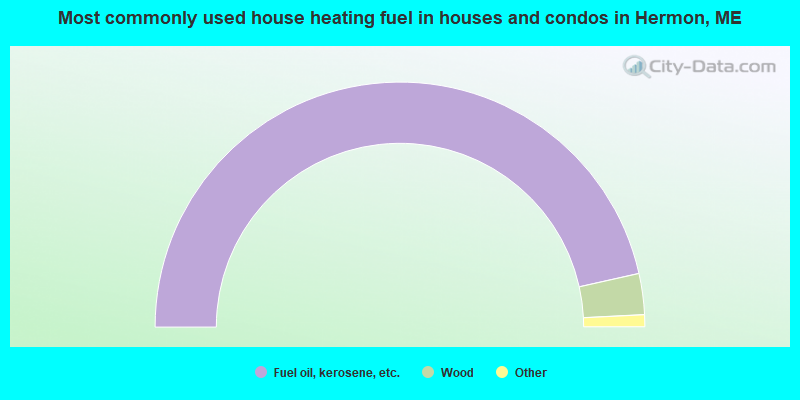
- 93.0%Fuel oil, kerosene, etc.
- 5.4%Wood
- 1.3%Bottled, tank, or LP gas
- 0.4%Other fuel
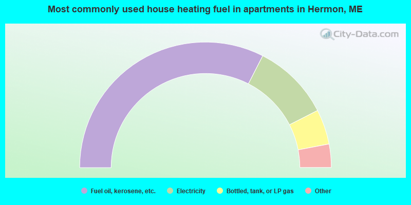
- 65.0%Fuel oil, kerosene, etc.
- 19.9%Electricity
- 9.0%Bottled, tank, or LP gas
- 3.8%Other fuel
- 2.3%Wood
Hermon compared to Maine state average:
- Unemployed percentage significantly below state average.
- Black race population percentage significantly below state average.
- Hispanic race population percentage below state average.
- Foreign-born population percentage significantly below state average.
- Renting percentage below state average.
- Length of stay since moving in significantly above state average.
- Number of rooms per house significantly below state average.
- House age significantly below state average.
Hermon on our top lists:
- #1 on the list of "Top 101 cities with largest percentage of males in industries: electrical and electronic goods merchant wholesalers (population 5,000+)"
- #3 on the list of "Top 101 cities with largest percentage of females in industries: recyclable material merchant wholesalers (population 5,000+)"
- #7 on the list of "Top 101 cities with largest percentage of males in industries: motor vehicle and parts dealers (population 5,000+)"
- #9 on the list of "Top 101 cities with largest percentage of males in industries: fuel dealers (population 5,000+)"
- #12 on the list of "Top 101 cities with largest percentage of females in occupations: financial clerks except bookkeeping, accounting, and auditing clerks (population 5,000+)"
- #13 on the list of "Top 101 cities with largest percentage of females in industries: vending machine operators (population 5,000+)"
- #17 on the list of "Top 101 cities with largest percentage of males in industries: recyclable material merchant wholesalers (population 5,000+)"
- #19 on the list of "Top 101 cities with largest percentage of males in industries: building material and garden equipment and supplies dealers (population 5,000+)"
- #22 on the list of "Top 101 cities with largest percentage of males in industries: gasoline stations (population 5,000+)"
- #23 on the list of "Top 101 cities with largest percentage of females in industries: miscellaneous durable goods merchant wholesalers (population 5,000+)"
- #26 on the list of "Top 101 cities with largest percentage of females in industries: rail transportation (population 5,000+)"
- #29 on the list of "Top 101 cities with largest percentage of males in industries: warehousing and storage (population 5,000+)"
- #32 on the list of "Top 101 cities with largest percentage of females in occupations: other protective service workers including supervisors (population 5,000+)"
- #38 on the list of "Top 101 cities with largest percentage of females in industries: leather and allied products (population 5,000+)"
- #39 on the list of "Top 101 cities with largest percentage of females in industries: book stores and news dealers (population 5,000+)"
- #42 on the list of "Top 101 cities with largest percentage of males in occupations: sales representatives, services, wholesale and manufacturing (population 5,000+)"
- #42 on the list of "Top 101 cities with largest percentage of females in industries: petroleum and petroleum products merchant wholesalers (population 5,000+)"
- #43 on the list of "Top 101 cities with largest percentage of males in industries: farm supplies merchant wholesalers (population 5,000+)"
- #49 on the list of "Top 101 cities with largest percentage of females in industries: truck transportation (population 5,000+)"
- #50 on the list of "Top 101 cities with largest percentage of males in industries: rail transportation (population 5,000+)"
- #26 on the list of "Top 101 counties with the highest percentage of residents that smoked 100+ cigarettes in their lives"
- #27 on the list of "Top 101 counties with the highest percentage of residents that drank alcohol in the past 30 days"
- #28 on the list of "Top 101 counties with highest percentage of residents voting for 3rd party candidates in the 2012 Presidential Election (pop. 50,000+)"
- #42 on the list of "Top 101 counties with the lowest number of births per 1000 residents 2007-2013"
- #44 on the list of "Top 101 counties with the lowest percentage of residents relocating to foreign countries in 2011 (pop. 50,000+)"

|
|
Total of 19 patent applications in 2008-2024.