Bangor, Maine
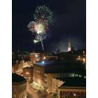
Bangor: Bangor Fireworks on Independence Day

Bangor: Indigo Sky Bangor
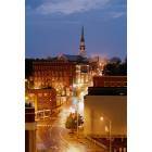
Bangor: Downtown Bangor at Night
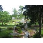
Bangor: Bangor Park, June 2007
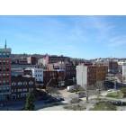
Bangor: Downtown

Bangor: Pierce Memorial - Bangor Maine
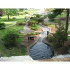
Bangor: Bangor Park
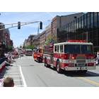
Bangor: July 4 2004 Parade - Bangor Maine
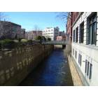
Bangor: Downtown from garage

Bangor: Historic Pickering Square with Church in background

Bangor: The beginning rumblings of a NorEaster in Bangor
- see
32
more - add
your
Submit your own pictures of this city and show them to the world
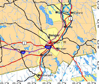
- OSM Map
- General Map
- Google Map
- MSN Map
Population change since 2000: +0.4%
 |
| Males: 14,692 | |
| Females: 16,896 |
| Median resident age: | 40.9 years |
| Maine median age: | 45.1 years |
| Bangor: | $53,934 |
| ME: | $69,543 |
Estimated per capita income in 2022: $37,549 (it was $19,295 in 2000)
Bangor city income, earnings, and wages data
Estimated median house or condo value in 2022: $216,445 (it was $83,800 in 2000)
| Bangor: | $216,445 |
| ME: | $290,600 |
Mean prices in 2022: all housing units: $241,573; detached houses: $272,059; townhouses or other attached units: $202,289; in 2-unit structures: $236,053; in 3-to-4-unit structures: $181,735; in 5-or-more-unit structures: $351,611; mobile homes: $54,367
Median gross rent in 2022: $933.
(15.5% for White Non-Hispanic residents, 8.3% for Black residents, 2.3% for Hispanic or Latino residents, 2.2% for American Indian residents, 8.8% for other race residents, 23.3% for two or more races residents)
Detailed information about poverty and poor residents in Bangor, ME


Compare current foreclosures near Bangor, ME:
| Photo | Address | Area | Beds / Baths | Price | Details |
|---|---|---|---|---|---|

|
#1
Union St
Bangor, ME 04401
|
1,512 sq. feet
|
2 baths 6 beds |
$54,900
|
show details |

|
#2
Maxwell Ln
Bangor, ME 04401
|
1,750 sq. feet
|
2 baths 3 beds |
show details | |

|
#3
Smokey Ln
Bangor, ME 04401
|
2,434 sq. feet
|
2 baths 3 beds |
show details | |

|
#4
Warren St
Bangor, ME 04401
|
2,842 sq. feet
|
3 baths 5 beds |
show details | |

|
#5
Grove St
Bangor, ME 04401
|
910 sq. feet
|
1 baths 3 beds |
show details | |

|
#6
Lancaster Ave
Bangor, ME 04401
|
324 sq. feet
|
1 baths 1 beds |
show details | |

|
#7
Allen St
Bangor, ME 04401
|
1,200 sq. feet
|
1 baths 3 beds |
show details | |

|
#8
Pine St # B
Bangor, ME 04401
|
- sq. feet
|
- baths - beds |
show details | |

|
#9
Cedar St Apt 4
Bangor, ME 04401
|
- sq. feet
|
- baths - beds |
show details | |

|
#10
Cedar Breeze N
Bangor, ME 04401
|
- sq. feet
|
- baths - beds |
show details |
| Photo | Address | Area | Beds / Baths | Price | Details |
|---|---|---|---|---|---|

|
#11
Aa Landing Rd
Bangor, ME 04401
|
- sq. feet
|
- baths - beds |
show details | |
|
|
#12
York Rd
Bangor, ME 04401
|
- sq. feet
|
- baths - beds |
show details | |

|
#13
Kenduskeag Ave # 24
Bangor, ME 04401
|
- sq. feet
|
- baths - beds |
show details | |

|
#14
Western Ave
Hampden, ME 04444
|
1,976 sq. feet
|
2 baths 4 beds |
show details | |

|
#15
Rd
Brewer, ME 04412
|
2,428 sq. feet
|
1 baths 4 beds |
show details | |

|
#16
Upper Cross Rd
Hudson, ME 04449
|
1,344 sq. feet
|
2 baths 3 beds |
show details | |

|
#17
Ichabod Ln
Hampden, ME 04444
|
960 sq. feet
|
1 baths 3 beds |
show details | |

|
#18
Kenduskeag Levant Rd
Kenduskeag, ME 04450
|
- sq. feet
|
2 baths 3 beds |
show details | |

|
#19
Western Ave
Hampden, ME 04444
|
1,825 sq. feet
|
1 baths 3 beds |
show details | |

|
#20
Indian Hill Ln
Frankfort, ME 04438
|
- sq. feet
|
- baths - beds |
show details |
| Photo | Address | Area | Beds / Baths | Price | Details |
|---|---|---|---|---|---|

|
#21
Mechanic St
Bucksport, ME 04416
|
- sq. feet
|
- baths - beds |
show details | |

|
#22
Call Rd # D
Milford, ME 04461
|
- sq. feet
|
- baths - beds |
show details | |

|
#23
Hampden Rd
Carmel, ME 04419
|
- sq. feet
|
- baths - beds |
show details | |

|
#24
Summer St
Old Town, ME 04468
|
- sq. feet
|
- baths - beds |
show details | |

|
#25
Bennoch Rd
Old Town, ME 04468
|
- sq. feet
|
- baths - beds |
show details | |

|
#26
Broadway
Kenduskeag, ME 04450
|
- sq. feet
|
- baths - beds |
show details | |

|
#27
Harris Rd Apt 31
Orono, ME 04473
|
- sq. feet
|
- baths - beds |
show details | |

|
#28
Pleasant Hill Ln
Orrington, ME 04474
|
- sq. feet
|
- baths - beds |
show details | |

|
#29
Baker Blvd Ste 205
Brewer, ME 04412
|
- sq. feet
|
- baths - beds |
show details | |

|
#30
Wolfboro Rd
Stetson, ME 04488
|
- sq. feet
|
- baths - beds |
show details |
| Photo | Address | Area | Beds / Baths | Price | Details |
|---|---|---|---|---|---|

|
#31
Merrill Rd
Eddington, ME 04428
|
- sq. feet
|
- baths - beds |
show details | |

|
#32
W Old Town Rd
Old Town, ME 04468
|
- sq. feet
|
- baths - beds |
show details | |

|
#33
Hudson Rd
Hudson, ME 04449
|
- sq. feet
|
- baths - beds |
show details | |

|
#34
Hudson Hill Rd
Hudson, ME 04449
|
- sq. feet
|
- baths - beds |
show details | |

|
#35
Central St
Bucksport, ME 04416
|
- sq. feet
|
- baths - beds |
show details | |

|
#36
Hinks St
Bucksport, ME 04416
|
- sq. feet
|
- baths - beds |
show details | |

|
#37
S Road
Brewer, ME 04412
|
- sq. feet
|
- baths - beds |
show details | |

|
#38
South Rd
Brewer, ME 04412
|
- sq. feet
|
- baths - beds |
show details | |

|
#39
Gott Brook Hts
Orland, ME 04472
|
- sq. feet
|
- baths - beds |
show details | |

|
Check over 1 million property listings on Foreclosure.com!
|
browse all offers | |||


- 27,81487.1%White alone
- 1,0623.3%Hispanic
- 1,0323.2%Two or more races
- 9192.9%Black alone
- 7982.5%Asian alone
- 4191.3%Other race alone
- 1780.6%American Indian alone
- 170.05%Native Hawaiian and Other
Pacific Islander alone
Races in Bangor detailed stats: ancestries, foreign born residents, place of birth
According to our research of Maine and other state lists, there were 98 registered sex offenders living in Bangor, Maine as of April 27, 2024.
The ratio of all residents to sex offenders in Bangor is 332 to 1.
Type |
2009 |
2010 |
2011 |
2012 |
2013 |
2014 |
2015 |
2016 |
2017 |
2018 |
2019 |
2020 |
2021 |
2022 |
|---|---|---|---|---|---|---|---|---|---|---|---|---|---|---|
| Murders (per 100,000) | 1 (3.1) | 3 (9.1) | 2 (6.1) | 6 (18.2) | 3 (9.2) | 1 (3.1) | 1 (3.1) | 0 (0.0) | 1 (3.1) | 4 (12.6) | 1 (3.1) | 2 (6.2) | 0 (0.0) | 0 (0.0) |
| Rapes (per 100,000) | 10 (31.5) | 4 (12.1) | 9 (27.2) | 7 (21.2) | 10 (30.5) | 4 (12.3) | 5 (15.4) | 15 (46.5) | 8 (25.1) | 4 (12.6) | 1 (3.1) | 7 (21.8) | 8 (25.1) | 7 (21.8) |
| Robberies (per 100,000) | 35 (110.1) | 30 (90.8) | 35 (105.9) | 40 (121.1) | 35 (106.9) | 22 (67.5) | 19 (58.5) | 30 (93.0) | 14 (44.0) | 15 (47.3) | 15 (47.1) | 13 (40.4) | 24 (75.2) | 19 (59.2) |
| Assaults (per 100,000) | 19 (59.8) | 15 (45.4) | 23 (69.6) | 23 (69.6) | 22 (67.2) | 28 (85.9) | 31 (95.5) | 30 (93.0) | 25 (78.6) | 33 (104.0) | 18 (56.5) | 29 (90.1) | 31 (97.2) | 26 (81.1) |
| Burglaries (per 100,000) | 284 (893.4) | 198 (599.3) | 249 (753.7) | 253 (765.8) | 243 (742.1) | 182 (558.5) | 173 (533.0) | 180 (557.9) | 181 (568.9) | 89 (280.4) | 64 (200.8) | 100 (310.8) | 133 (417.0) | 100 (311.7) |
| Thefts (per 100,000) | 1,884 (5,927) | 1,485 (4,495) | 1,389 (4,205) | 1,543 (4,671) | 1,564 (4,776) | 1,474 (4,523) | 1,086 (3,346) | 1,123 (3,481) | 1,004 (3,156) | 1,151 (3,626) | 1,076 (3,376) | 1,044 (3,244) | 1,272 (3,988) | 1,417 (4,417) |
| Auto thefts (per 100,000) | 42 (132.1) | 47 (142.3) | 34 (102.9) | 46 (139.2) | 37 (113.0) | 22 (67.5) | 17 (52.4) | 37 (114.7) | 24 (75.4) | 60 (189.0) | 28 (87.9) | 63 (195.8) | 56 (175.6) | 33 (102.9) |
| Arson (per 100,000) | 1 (3.1) | 9 (27.2) | 1 (3.0) | 3 (9.1) | 4 (12.2) | 7 (21.5) | 5 (15.4) | 1 (3.1) | 2 (6.3) | 2 (6.3) | 4 (12.6) | 0 (0.0) | 7 (21.9) | 8 (24.9) |
| City-Data.com crime index | 386.6 | 297.3 | 308.8 | 355.1 | 340.3 | 278.8 | 230.5 | 271.1 | 227.4 | 250.0 | 190.3 | 227.2 | 264.8 | 258.2 |
The City-Data.com crime index weighs serious crimes and violent crimes more heavily. Higher means more crime, U.S. average is 246.1. It adjusts for the number of visitors and daily workers commuting into cities.
Crime rate in Bangor detailed stats: murders, rapes, robberies, assaults, burglaries, thefts, arson
Full-time law enforcement employees in 2021, including police officers: 93 (81 officers - 72 male; 9 female).
| Officers per 1,000 residents here: | 2.54 |
| Maine average: | 1.71 |
 Recent articles from our blog. Our writers, many of them Ph.D. graduates or candidates, create easy-to-read articles on a wide variety of topics.

 | Potential Move to Bangor (14 replies) |
| Bangor vs Burlington VT (16 replies) |
| Bangor to Declare War? (76 replies) |
| Bangor area schools (4 replies) |
| Choice between Bangor and Rockland (13 replies) |
| Driving from Bangor to Stockholm (5 replies) |
Latest news from Bangor, ME collected exclusively by city-data.com from local newspapers, TV, and radio stations
Bangor, ME City Guides:
Ancestries: English (19.2%), Irish (11.0%), French (8.0%), American (7.5%), French Canadian (6.7%), Italian (3.7%).
Current Local Time: EST time zone
Incorporated on 02/24/1834
Elevation: 158 feet
Land area: 34.4 square miles.
Population density: 917 people per square mile (low).
1,658 residents are foreign born (1.6% Latin America, 1.4% Asia, 0.8% Europe, 0.7% North America, 0.6% Africa).
| This city: | 5.2% |
| Maine: | 3.8% |
Median real estate property taxes paid for housing units with mortgages in 2022: $2,833 (1.2%)
Median real estate property taxes paid for housing units with no mortgage in 2022: $2,603 (1.4%)
Nearest city with pop. 50,000+: Portland, ME  (108.2 miles , pop. 64,249).
Nearest city with pop. 200,000+: Boston, MA (207.3 miles , pop. 589,141).
Nearest city with pop. 1,000,000+: Bronx, NY (376.5 miles , pop. 1,332,650).
Nearest cities:
), ), ), ), )Latitude: 44.81 N, Longitude: 68.78 W
Daytime population change due to commuting: +19,024 (+59.6%)
Workers who live and work in this city: 10,624 (68.4%)
Area code: 207
Detailed articles:
- Bangor: Introduction
- Bangor Basic Facts
- Bangor: Communications
- Bangor: Convention Facilities
- Bangor: Economy
- Bangor: Education and Research
- Bangor: Geography and Climate
- Bangor: Health Care
- Bangor: History
- Bangor: Municipal Government
- Bangor: Population Profile
- Bangor: Recreation
- Bangor: Transportation
Bangor, Maine accommodation & food services, waste management - Economy and Business Data
Single-family new house construction building permits:
- 2022: 36 buildings, average cost: $319,800
- 2021: 18 buildings, average cost: $309,500
- 2020: 21 buildings, average cost: $248,600
- 2019: 16 buildings, average cost: $250,100
- 2018: 37 buildings, average cost: $181,500
- 2017: 54 buildings, average cost: $204,100
- 2016: 10 buildings, average cost: $241,400
- 2015: 12 buildings, average cost: $283,700
- 2014: 13 buildings, average cost: $267,400
- 2013: 6 buildings, average cost: $245,900
- 2012: 13 buildings, average cost: $263,100
- 2011: 20 buildings, average cost: $230,600
- 2010: 31 buildings, average cost: $212,400
- 2009: 33 buildings, average cost: $220,600
- 2008: 41 buildings, average cost: $208,300
- 2007: 57 buildings, average cost: $180,900
- 2006: 72 buildings, average cost: $159,900
- 2005: 86 buildings, average cost: $181,100
- 2004: 65 buildings, average cost: $125,900
- 2003: 40 buildings, average cost: $119,400
- 2002: 26 buildings, average cost: $93,200
- 2001: 24 buildings, average cost: $97,600
- 2000: 21 buildings, average cost: $94,800
- 1999: 13 buildings, average cost: $99,600
- 1998: 14 buildings, average cost: $93,400
- 1997: 10 buildings, average cost: $111,100
| Here: | 3.2% |
| Maine: | 3.4% |
- Health care (16.7%)
- Educational services (11.3%)
- Accommodation & food services (8.4%)
- Construction (4.4%)
- Public administration (3.8%)
- Social assistance (3.7%)
- Finance & insurance (3.7%)
- Health care (10.4%)
- Educational services (8.7%)
- Accommodation & food services (7.9%)
- Construction (7.9%)
- Public administration (4.8%)
- Professional, scientific, technical services (3.8%)
- Motor vehicle & parts dealers (3.6%)
- Health care (23.0%)
- Educational services (14.0%)
- Accommodation & food services (8.9%)
- Social assistance (6.4%)
- Department & other general merchandise stores (4.4%)
- Finance & insurance (4.2%)
- Food & beverage stores (3.1%)
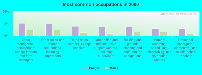
- Other management occupations, except farmers and farm managers (5.1%)
- Other sales and related occupations, including supervisors (5.0%)
- Retail sales workers, except cashiers (3.9%)
- Other office and administrative support workers, including supervisors (3.7%)
- Building and grounds cleaning and maintenance occupations (3.7%)
- Material recording, scheduling, dispatching, and distributing workers (3.0%)
- Preschool, kindergarten, elementary, and middle school teachers (3.0%)

- Other management occupations, except farmers and farm managers (5.8%)
- Other sales and related occupations, including supervisors (5.2%)
- Electrical equipment mechanics and other installation, maintenance, and repair workers, including supervisors (4.5%)
- Building and grounds cleaning and maintenance occupations (4.3%)
- Material recording, scheduling, dispatching, and distributing workers (4.2%)
- Retail sales workers, except cashiers (3.9%)
- Driver/sales workers and truck drivers (3.3%)

- Other office and administrative support workers, including supervisors (5.6%)
- Preschool, kindergarten, elementary, and middle school teachers (4.9%)
- Other sales and related occupations, including supervisors (4.8%)
- Counselors, social workers, and other community and social service specialists (4.4%)
- Other management occupations, except farmers and farm managers (4.4%)
- Registered nurses (4.0%)
- Retail sales workers, except cashiers (3.8%)
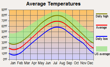
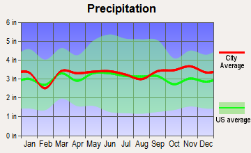
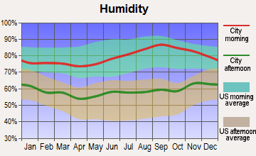
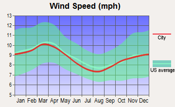
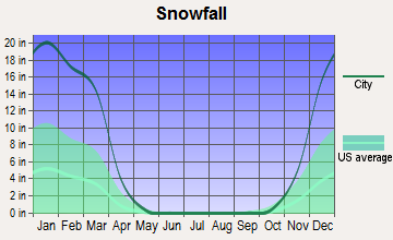
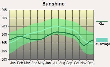
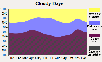
Average climate in Bangor, Maine
Based on data reported by over 4,000 weather stations
|
|

(lower is better)
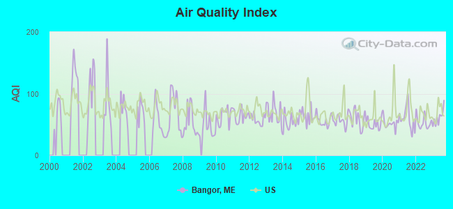
Air Quality Index (AQI) level in 2023 was 61.1. This is about average.
| City: | 61.1 |
| U.S.: | 72.6 |
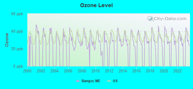
Ozone [ppb] level in 2023 was 33.6. This is about average. Closest monitor was 6.0 miles away from the city center.
| City: | 33.6 |
| U.S.: | 33.3 |
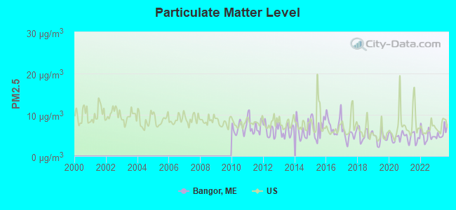
Particulate Matter (PM2.5) [µg/m3] level in 2023 was 5.62. This is significantly better than average. Closest monitor was 0.7 miles away from the city center.
| City: | 5.62 |
| U.S.: | 8.11 |
Earthquake activity:
Bangor-area historical earthquake activity is significantly above Maine state average. It is 81% smaller than the overall U.S. average.On 4/20/2002 at 10:50:47, a magnitude 5.3 (5.3 ML, Depth: 3.0 mi, Class: Moderate, Intensity: VI - VII) earthquake occurred 242.6 miles away from the city center
On 10/16/2012 at 23:12:25, a magnitude 4.7 (4.7 ML, Depth: 10.0 mi, Class: Light, Intensity: IV - V) earthquake occurred 125.2 miles away from Bangor center
On 4/20/2002 at 10:50:47, a magnitude 5.2 (5.2 MB, 4.2 MS, 5.2 MW, 5.0 MW) earthquake occurred 243.8 miles away from the city center
On 10/7/1983 at 10:18:46, a magnitude 5.3 (5.1 MB, 5.3 LG, 5.1 ML) earthquake occurred 281.1 miles away from the city center
On 1/19/1982 at 00:14:42, a magnitude 4.7 (4.5 MB, 4.7 MD, 4.5 LG) earthquake occurred 166.6 miles away from Bangor center
On 2/26/1999 at 03:38:43, a magnitude 3.8 (3.8 LG, Depth: 2.0 mi, Class: Light, Intensity: II - III) earthquake occurred 42.9 miles away from the city center
Magnitude types: regional Lg-wave magnitude (LG), body-wave magnitude (MB), duration magnitude (MD), local magnitude (ML), surface-wave magnitude (MS), moment magnitude (MW)
Natural disasters:
The number of natural disasters in Penobscot County (19) is greater than the US average (15).Major Disasters (Presidential) Declared: 11
Emergencies Declared: 7
Causes of natural disasters: Floods: 9, Storms: 8, Snows: 5, Heavy Rains: 2, Blizzard: 1, Hurricane: 1, Ice Storm: 1, Snowfall: 1, Wind: 1, Winter Storm: 1, Other: 2 (Note: some incidents may be assigned to more than one category).
Main business address for: MERRILL MERCHANTS BANCSHARES INC (FUNCTIONS RELATED TO DEPOSITORY BANKING, NEC), NYER MEDICAL GROUP INC (WHOLESALE-MEDICAL, DENTAL & HOSPITAL EQUIPMENT & SUPPLIES).
Hospitals in Bangor:
- ACADIA HOSPITAL,THE (provides emergency services, 268 STILLWATER AVE)
- EASTERN MAINE MEDICAL CENTER (Voluntary non-profit - Private, provides emergency services, 489 STATE ST, PO BOX 404)
- ELIZABETH LEVINSON CENTER (159 HOGAN RD)
- HOSPICE OF EASTERN MAINE (855 UNION ST)
- ST JOSEPH HOSPICE (900 BROADWAY)
- ST JOSEPH HOSPITAL (Voluntary non-profit - Church, 360 BROADWAY)
- TAYLOR HOSPITAL (268 STILLWATER AVE)
Nursing Homes in Bangor:
- BANGOR MENTAL HEALTH INSTITUTE (PO BOX 926)
- BANGOR NURSING AND REHABILITATION (103 TEXAS AVE)
- EASTSIDE REHAB AND LIVING CENTER (516 MT HOPE AVENUE)
- KINDRED NURSING AND REHABILITATION-WESTGATE (750 UNION ST)
- MAINE VETERANS HOME - BANGOR (44 HOGAN RD)
- ROSS MANOR (758 BROADWAY)
- STILLWATER HEALTH CARE (335 STILLWATER AVE)
Dialysis Facilities in Bangor:
Home Health Centers in Bangor:
- AMEDISYS HOME HEALTH OF BANGOR (23 WATER ST., SUITE 208)
- BANGOR AREA VISITING NURSES (885 UNION STREET, SUITE 220)
- CHANDLER BAY HOME HEALTH AGENCY INC (6 STATE STREET SUITE 204)
- COMMUNITY HEALTH AND COUNSELING SERVICES (P.O. BOX 425)
- GENTIVA HEALTH SERVICES (175 EXCHANGE STREET, SUITE 100)
- HOSPICE OF EASTERN MAINE HHA (412 STATE ST)
- ST JOSEPH HOMECARE (900 BROADWAY, ST JOSEPH HEALTHCARE PARK BLDG 2)
Airports, heliports and other landing facilities located in Bangor:
- Bangor International Airport (BGR) (Runways: 2, Commercial Ops: 14,673, Itinerant Ops: 13,540, Local Ops: 3,527, Military Ops: 10,986)
- Eastern Maine Medical Center Heliport (ME02)
- Lucky Landing Marina And Seaplane Base (06B)
Colleges/Universities in Bangor:
- Husson University (Full-time enrollment: 2,421; Location: 1 College Circle; Private, not-for-profit; Website: www.husson.edu; Offers Doctor's degree)
- Eastern Maine Community College (Full-time enrollment: 1,718; Location: 354 Hogan Rd; Public; Website: www.emcc.edu)
- Beal College (Full-time enrollment: 487; Location: 99 Farm Road; Private, for-profit; Website: www.bealcollege.edu/)
- New England School of Communications (Full-time enrollment: 465; Location: 1 College Circle; Private, not-for-profit; Website: www.nescom.edu)
- University of Maine-System Central Office (Location: 16 Central Street; Public; Website: WWW.MAINE.EDU; Offers Doctor's degree)
- Bangor Theological Seminary (Location: Two College Circle; Private, not-for-profit; Offers Doctor's degree)
Other colleges/universities with over 2000 students near Bangor:
- University of Maine (about 8 miles; Orono, ME; Full-time enrollment: 8,931)
- University of Maine at Augusta (about 60 miles; Augusta, ME; FT enrollment: 3,204)
- University of Maine at Farmington (about 68 miles; Farmington, ME; FT enrollment: 2,036)
- Southern Maine Community College (about 108 miles; South Portland, ME; FT enrollment: 4,666)
- Saint Joseph's College of Maine (about 109 miles; Standish, ME; FT enrollment: 2,010)
- University of Southern Maine (about 109 miles; Portland, ME; FT enrollment: 6,647)
- University of New England (about 123 miles; Biddeford, ME; FT enrollment: 4,539)
Public high school in Bangor:
- BANGOR HIGH SCHOOL (Location: 885 BROADWAY, Grades: 9-12)
Private high schools in Bangor:
- JOHN BAPST MEMORIAL HIGH SCHOOL (Students: 467, Location: 100 BROADWAY, Grades: 9-12)
- BANGOR CHRISTIAN SCHOOLS (Students: 288, Location: 1476 BROADWAY, Grades: PK-12)
Public elementary/middle schools in Bangor:
- FAIRMOUNT SCHOOL (Students: 297, Location: 58 THIRTEENTH STREET, Grades: 4-5)
- FRUIT STREET SCHOOL (Students: 287, Location: 175 FRUIT STREET, Grades: PK-3)
- DOWNEAST SCHOOL (Students: 269, Location: 100 MOOSEHEAD BLVD, Grades: PK-3)
- ABRAHAM LINCOLN SCHOOL (Students: 204, Location: 45 FOREST AVENUE, Grades: PK-3)
- FOURTEENTH STREET SCHOOL (Students: 156, Location: 224 FOURTEENTH STREET, Grades: PK-3)
- JAMES F. DOUGHTY SCHOOL (Location: 143 FIFTH STREET, Grades: 6-8)
- WILLIAM S. COHEN SCHOOL (Location: 304 GARLAND STREET, Grades: 6-8)
- VINE STREET SCHOOL (Location: 66 VINE STREET, Grades: PK-3)
- MARY SNOW SCHOOL (Location: 435 BROADWAY, Grades: 4-5)
Private elementary/middle schools in Bangor:
Points of interest:
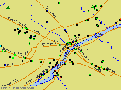
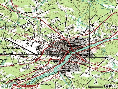
Notable locations in Bangor: Sylvan Road Industrial Park (A), Paul Bunyan Campground (B), Maine Business Enterprise Park (C), Hildreth Industrial Park (D), Griffin Magnetic Station (E), Dowd Industrial Park (F), Broadway Magnetic Station (G), Bonair Industrial Park (H), Bomarc Industrial Park (I), Bangor Waterfront and Landing (J), Bangor Municipal Pier (K), Bangor Municipal Golf Course (L), Meadowbrook Golf Club (M), Bangor Fire Department Station 5 (N), Northeastern Maine Emergency Medical Services Ambulance (O), LifeFlight of Maine Bangor (P), Mobile Health Capital Ambulance (Q), University College Library (R), Stillwater Health Care Center (S), Penobscot County Law Library (T). Display/hide their locations on the map
Shopping Centers: Mid Mall Shopping Center (1), Maine Square Mall Shopping Center (2), Center Mall Shopping Center (3), Broadway Shopping Center (4), Bangor Mall Shopping Center (5), Airport Mall (6), Westgate Mall (7). Display/hide their locations on the map
Main business address in Bangor include: MERRILL MERCHANTS BANCSHARES INC (A), NYER MEDICAL GROUP INC (B). Display/hide their locations on the map
Churches in Bangor include: Hammond Street Congregational Church (A), Grace Christian Church (B), Glad Tidings Church (C), Forest Avenue Congregational Church (D), Unitarian Universalist Society (E), First United Methodist Church (F), First Church of Christian Science (G), First Baptist Church (H), Essex Street Baptist Church (I). Display/hide their locations on the map
Cemeteries: Maple Grove Cemetery (1), Pine Grove Cemetery (2), Congregation Beth Israel Cemetery (3), Beth Abraham Cemetery (4), Mount Pleasant Cemetery (5), Mount Hope Cemetery (6), Oak Grove Cemetery (7). Display/hide their locations on the map
Streams, rivers, and creeks: Kenduskeag Stream (A), Meadow Brook (B), Penjajawoc Stream (C), Great Brook (D), Osgood Brook (E). Display/hide their locations on the map
Parks in Bangor include: Broadway Park (1), Great Fire of 1911 Historic District (2), Second Street Park (3), Dakin Park (4), Hamlin Mall (5), Old Cemetery Lot Park (6), Summit Park (7), Stillwater Park Playground (8), Grotto Cascade Park (9). Display/hide their locations on the map
Tourist attractions: Cole Land Transportation Museum (405 Perry Road) (1), Maine Discovery Museum (74 Main Street) (2), Bangor Museum & Center for History (6 State Street Suite 102) (3), Maine Aviation Historical Society (Museums; 99 Maine Avenue) (4), Hose 5 Fire Museum (247 State Street) (5), Bangor Historical Society (Museums; 159 Union Street) (6), Eastern Maine Community College - Housing and Residential Life Office- Lib (Cultural Attractions- Events- & Facilities; 354 Hogan Road) (7), Penquis Cap Resource Development Center - Childcare Referrals for Par (Cultural Attractions- Events- & Facilities; 262 Harlow Street) (8), CVB Airport Information Center (287 Godfrey Boulevard) (9). Display/hide their approximate locations on the map
Hotels: Riverside Inn Bangor (495 State Street) (1), Hampton Inn Bangor (10 Bangor Mall Boulevard) (2), Main Street Inn (480 Main Street) (3), Four Points By Sheraton Bangor Airport (308 Godfrey Boulevard) (4), Econo Lodge Bangor (327 Odlin Road) (5), Super 8 Bangor ME (462 Odlin Road) (6), Best Inn (570 Main Street) (7), Motel 6 (1100 Hammond Street) (8), Days Inn Bangor (250 Odlin Road) (9). Display/hide their approximate locations on the map
Courts: Maine State - Courts- Superior Court (84 Harlow Street) (1), Maine State - Courts- District Court- Transcript Division (84 Harlow Street) (2), Maine State - Courts- Superior Court- Court Chambers (84 Harlow Street) (3), Maine State - Courts- Maine Supreme Judicial Court- Justice Silver (97 Hammond Street) (4), Maine State - Courts- District Court- Bangor (73 Hammond Street) (5). Display/hide their approximate locations on the map
Birthplace of: William Cohen - Businessman, Frank Barbour - Football player and coach, Gary Thorne - Radio sports announcer, Joe Hill (writer) - Horror writer, John Baldacci - Politician, Edward Cornelius O'Leary - Catholic bishop, Eliot Cutler - Lawyer, Elliott Cutler - Surgeon, Charles Rocket - Actor, Harry Orman Robinson - Football player and coach.
Drinking water stations with addresses in Bangor and their reported violations in the past:
CAMP PIERCE WEBBER (Population served: 165, Groundwater):Past health violations:MDOC ST PK - PEAKS-KENNY (Population served: 149, Groundwater):Past monitoring violations:
- MCL, Monthly (TCR) - In AUG-2011, Contaminant: Coliform. Follow-up actions: St Public Notif requested (AUG-24-2011), St Formal NOV issued (AUG-24-2011), St Public Notif received (JUN-12-2012), St Compliance achieved (AUG-10-2012)
- MCL, Monthly (TCR) - In JUL-2011, Contaminant: Coliform. Follow-up actions: St Public Notif requested (JUL-27-2011), St Formal NOV issued (JUL-27-2011), St Public Notif received (AUG-30-2011), St Compliance achieved (AUG-10-2012)
- MCL, Monthly (TCR) - In JUL-2008, Contaminant: Coliform. Follow-up actions: St Public Notif requested (AUG-13-2008), St Formal NOV issued (AUG-13-2008), St Compliance achieved (SEP-06-2011), St Intentional no-action (SEP-09-2011)
- MCL, Monthly (TCR) - In AUG-2007, Contaminant: Coliform. Follow-up actions: St Public Notif received (AUG-27-2007), St Public Notif requested (SEP-10-2007), St Formal NOV issued (SEP-10-2007), St Compliance achieved (SEP-06-2011), St Intentional no-action (SEP-09-2011)
- MCL, Monthly (TCR) - In AUG-2005, Contaminant: Coliform. Follow-up actions: St Public Notif requested (NOV-21-2005), St Violation/Reminder Notice (NOV-21-2005), St Intentional no-action (AUG-01-2011), St Compliance achieved (AUG-10-2012)
- One minor monitoring violation
Past health violations:DUNKIN DONUTS- CORINTH (Population served: 145, Groundwater):Past monitoring violations:
- MCL, Monthly (TCR) - In JUL-2010, Contaminant: Coliform. Follow-up actions: St Public Notif requested (AUG-02-2010), St Formal NOV issued (AUG-02-2010), St Compliance achieved (MAY-15-2012), St Public Notif received (MAY-15-2012)
- MCL, Acute (TCR) - In AUG-2006, Contaminant: Coliform. Follow-up actions: St Tech Assistance Visit (AUG-23-2006), St Violation/Reminder Notice (AUG-23-2006), St Boil Water Order (AUG-23-2006), St Public Notif requested (AUG-23-2006), St Public Notif received (2 times from AUG-26-2006 to AUG-26-2006), St Compliance achieved (MAY-13-2008)
- One routine major monitoring violation
Past monitoring violations:PAUL BUNYAN CAMPGROUND (Population served: 127, Groundwater):
- 3 routine major monitoring violations
Past health violations:TOWN & COUNTRY TRAILER PARK (Population served: 98, Groundwater):Past monitoring violations:
- MCL, Monthly (TCR) - In MAY-2007, Contaminant: Coliform. Follow-up actions: St Public Notif requested (JUN-11-2007), St Violation/Reminder Notice (JUN-11-2007), St Compliance achieved (MAY-25-2011), St Intentional no-action (SEP-15-2011)
- MCL, Monthly (TCR) - In AUG-2006, Contaminant: Coliform. Follow-up actions: St Public Notif requested (OCT-04-2006), St Violation/Reminder Notice (OCT-04-2006), St Compliance achieved (MAY-25-2011), St Intentional no-action (SEP-15-2011)
- MCL, Monthly (TCR) - In JUL-2006, Contaminant: Coliform. Follow-up actions: St Public Notif requested (AUG-07-2006), St Violation/Reminder Notice (AUG-07-2006), St Public Notif received (2 times from AUG-24-2006 to AUG-24-2006), St Compliance achieved (MAY-25-2011)
- MCL, Monthly (TCR) - In JUN-2005, Contaminant: Coliform. Follow-up actions: St Public Notif requested (JUN-27-2005), St Violation/Reminder Notice (JUN-27-2005), St Public Notif received (2 times from JUL-13-2005 to JUL-13-2005), St Compliance achieved (MAY-25-2011)
- One routine major monitoring violation
Past health violations:SWEET FERN TRAILER PK INC (Population served: 90, Groundwater):Past monitoring violations:
- MCL, Monthly (TCR) - In DEC-2010, Contaminant: Coliform. Follow-up actions: St Public Notif requested (DEC-22-2010), St Formal NOV issued (DEC-22-2010), St Public Notif received (JAN-12-2011), St Compliance achieved (APR-25-2012)
- MCL, Monthly (TCR) - In DEC-2005, Contaminant: Coliform. Follow-up actions: St Public Notif requested (DEC-29-2005), St Violation/Reminder Notice (DEC-29-2005), St Public Notif received (2 times from JAN-12-2006 to JAN-12-2006), St Compliance achieved (AUG-19-2009)
- 2 routine major monitoring violations
- 49 regular monitoring violations
Past monitoring violations:WENTWORTH MOBILE HOME PARK (Population served: 75, Groundwater):
- 5 routine major monitoring violations
Past health violations:SUNNY GABLES- GLENBURN HOUSING (Population served: 74, Groundwater):Past monitoring violations:
- MCL, Acute (TCR) - In MAY-2013, Contaminant: Coliform. Follow-up actions: St Formal NOV issued (MAY-29-2013), St Compliance Meeting conducted (MAY-29-2013), St Public Notif requested (MAY-29-2013), St Tech Assistance Visit (MAY-29-2013), St Boil Water Order (MAY-29-2013), St Public Notif received (JUL-18-2013)
- 4 routine major monitoring violations
Past health violations:Past monitoring violations:
- Public Education - In DEC-10-2005, Contaminant: Lead and Copper Rule. Follow-up actions: St Violation/Reminder Notice (MAR-20-2006), St Compliance achieved (JUL-21-2006)
- MCL, Single Sample - In OCT-2005, Contaminant: Nitrate. Follow-up actions: St Tech Assistance Visit (OCT-07-2005), St Violation/Reminder Notice (OCT-07-2005), St Public Notif requested (OCT-07-2005), St Compliance achieved (DEC-05-2005), St Intentional no-action (AUG-26-2011)
- MCL, Single Sample - In APR-2005, Contaminant: Nitrate. Follow-up actions: St Compliance Meeting conducted (APR-06-2005), St Violation/Reminder Notice (APR-06-2005), St Public Notif requested (APR-06-2005), St Tech Assistance Visit (APR-06-2005), St Public Notif received (2 times from APR-19-2005 to APR-19-2005), St Compliance achieved (MAY-03-2005)
- 2 routine major monitoring violations
- 7 regular monitoring violations
Drinking water stations with addresses in Bangor that have no violations reported:
- BANGOR WATER DISTRICT (Population served: 28,290, Primary Water Source Type: Surface water)
- MDOC ST PK - PEAKS-KENNY-SITE 33 (Population served: 140, Primary Water Source Type: Groundwater)
- TOWNE CENTER-RIDGEWOOD APARTMENTS (Population served: 60, Primary Water Source Type: Groundwater)
- MATTAWAMKEAG HOUSING CORP (Population served: 33, Primary Water Source Type: Groundwater)
- ACADIA HEALTHCARE/HBR SCHOOLS (Population served: 29, Primary Water Source Type: Groundwater)
| This city: | 2.1 people |
| Maine: | 2.3 people |
| This city: | 49.6% |
| Whole state: | 62.9% |
| This city: | 10.5% |
| Whole state: | 9.4% |
Likely homosexual households (counted as self-reported same-sex unmarried-partner households)
- Lesbian couples: 0.6% of all households
- Gay men: 0.4% of all households
People in group quarters in Bangor in 2010:
- 1,081 people in college/university student housing
- 561 people in nursing facilities/skilled-nursing facilities
- 298 people in workers' group living quarters and job corps centers
- 186 people in local jails and other municipal confinement facilities
- 161 people in emergency and transitional shelters (with sleeping facilities) for people experiencing homelessness
- 106 people in residential treatment centers for adults
- 100 people in group homes intended for adults
- 90 people in other noninstitutional facilities
- 62 people in mental (psychiatric) hospitals and psychiatric units in other hospitals
- 26 people in correctional residential facilities
- 13 people in group homes for juveniles (non-correctional)
- 6 people in residential treatment centers for juveniles (non-correctional)
People in group quarters in Bangor in 2000:
- 581 people in other noninstitutional group quarters
- 541 people in college dormitories (includes college quarters off campus)
- 468 people in nursing homes
- 243 people in job corps and vocational training facilities
- 130 people in local jails and other confinement facilities (including police lockups)
- 113 people in mental (psychiatric) hospitals or wards
- 65 people in other group homes
- 61 people in state prisons
- 58 people in homes for the mentally ill
- 51 people in homes for the mentally retarded
- 15 people in other nonhousehold living situations
- 13 people in schools, hospitals, or wards for the intellectually disabled
- 11 people in religious group quarters
- 6 people in homes or halfway houses for drug/alcohol abuse
- 4 people in orthopedic wards and institutions for the physically handicapped
Banks with branches in Bangor (2011 data):
- Bangor Savings Bank: Maine Avenue Branch, at 3 State Street, Bangor Branch, Hogan Road Branch, Bangor Branch, Bangor Branch. Info updated 2008/12/02: Bank assets: $2,556.3 mil, Deposits: $1,940.3 mil, local headquarters, positive income, Commercial Lending Specialization, 58 total offices, Holding Company: Bangor Bancorp, Mhc
- People's United Bank: Merrill Merchants Bank Branch, Union Street Branch, Bangor Branch, Crossroads Branch. Info updated 2012/02/16: Bank assets: $27,319.3 mil, Deposits: $20,835.4 mil, headquarters in Bridgeport, CT, positive income, Commercial Lending Specialization, 374 total offices
- Bank of America, National Association: Bangor Mall Branch, Bangor-Exchange Street Branch, Bangor Union Street Branch. Info updated 2009/11/18: Bank assets: $1,451,969.3 mil, Deposits: $1,077,176.8 mil, headquarters in Charlotte, NC, positive income, 5782 total offices, Holding Company: Bank Of America Corporation
- TD Bank, National Association: Bangor Main Branch, Stillwater Ave./Bangor, Union Street Branch. Info updated 2010/10/04: Bank assets: $188,912.6 mil, Deposits: $153,149.8 mil, headquarters in Wilmington, DE, positive income, 1314 total offices, Holding Company: Toronto-Dominion Bank, The
- Katahdin Trust Company: Bangor Branch at 12 Stillwater Avenue, branch established on 2008/03/12; Broadway Bangor Branch at 609 Broadway, branch established on 2010/08/02. Info updated 2007/04/25: Bank assets: $527.8 mil, Deposits: $425.6 mil, headquarters in Patten, ME, positive income, Commercial Lending Specialization, 19 total offices, Holding Company: Katahdin Bankshares Corporation
- KeyBank National Association: Bangor Key Plaza Branch at 23 Water Street, branch established on 1900/01/01; Mid-Mall Branch at 29 Bangor Mall Boulevard, branch established on 1984/05/25. Info updated 2008/03/03: Bank assets: $86,198.8 mil, Deposits: $64,214.8 mil, headquarters in Cleveland, OH, positive income, Commercial Lending Specialization, 1067 total offices, Holding Company: Keycorp
- The Camden National Bank: Unitedkingfield Bank Branch at 145 Exchange Street, branch established on 1895/05/01. Info updated 2008/02/27: Bank assets: $2,266.8 mil, Deposits: $1,604.6 mil, headquarters in Camden, ME, positive income, Commercial Lending Specialization, 39 total offices, Holding Company: Camden National Corporation
- Machias Savings Bank: Bangor Branch at 1126 Hammond Street, branch established on 2004/11/01. Info updated 2008/08/20: Bank assets: $933.5 mil, Deposits: $794.5 mil, headquarters in Machias, ME, positive income, Commercial Lending Specialization, 13 total offices, Holding Company: Machias Bancorp, Mhc
For population 15 years and over in Bangor:
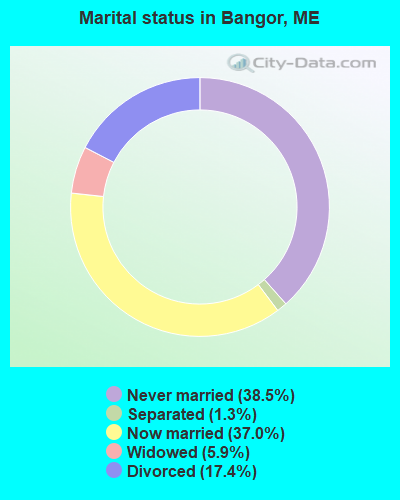
- Never married: 38.5%
- Now married: 37.0%
- Separated: 1.3%
- Widowed: 5.9%
- Divorced: 17.4%
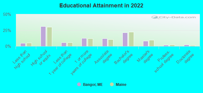
For population 25 years and over in Bangor:
- High school or higher: 95.0%
- Bachelor's degree or higher: 36.5%
- Graduate or professional degree: 14.0%
- Unemployed: 5.5%
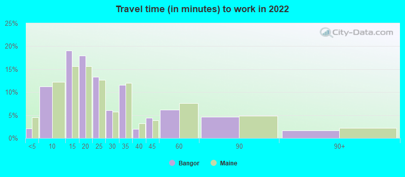
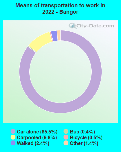
- Mean travel time to work (commute): 15.5 minutes
| Here: | 10.1 |
| Maine average: | 10.3 |


Graphs represent county-level data. Detailed 2008 Election Results
Religion statistics for Bangor, ME (based on Penobscot County data)


| Religion | Adherents | Congregations |
|---|---|---|
| Catholic | 16,581 | 15 |
| Mainline Protestant | 9,715 | 59 |
| Evangelical Protestant | 7,523 | 80 |
| Other | 2,936 | 22 |
| Orthodox | 300 | 1 |
| None | 116,868 | - |
Food Environment Statistics:
| Penobscot County: | 2.29 / 10,000 pop. |
| Maine: | 2.80 / 10,000 pop. |
| This county: | 0.13 / 10,000 pop. |
| State: | 0.14 / 10,000 pop. |
| Penobscot County: | 2.56 / 10,000 pop. |
| Maine: | 2.20 / 10,000 pop. |
| Penobscot County: | 5.72 / 10,000 pop. |
| State: | 5.75 / 10,000 pop. |
| Here: | 7.41 / 10,000 pop. |
| State: | 11.02 / 10,000 pop. |
| This county: | 9.0% |
| Maine: | 8.2% |
| Penobscot County: | 28.0% |
| Maine: | 25.0% |
Health and Nutrition:
| Here: | 52.4% |
| Maine: | 53.9% |
| This city: | 51.8% |
| Maine: | 52.9% |
| This city: | 28.3 |
| Maine: | 28.3 |
| Here: | 21.0% |
| Maine: | 19.9% |
| Bangor: | 9.5% |
| Maine: | 8.7% |
| Bangor: | 6.9 |
| Maine: | 6.9 |
| This city: | 33.2% |
| Maine: | 34.3% |
| Here: | 60.1% |
| Maine: | 60.5% |
| Bangor: | 80.1% |
| Maine: | 79.6% |
More about Health and Nutrition of Bangor, ME Residents
| Local government employment and payroll (March 2022) | |||||
| Function | Full-time employees | Monthly full-time payroll | Average yearly full-time wage | Part-time employees | Monthly part-time payroll |
|---|---|---|---|---|---|
| Elementary and Secondary - Instruction | 489 | $2,594,609 | $63,671 | 46 | $66,546 |
| Elementary and Secondary - Other Total | 121 | $406,067 | $40,271 | 7 | $5,691 |
| Airports | 100 | $520,607 | $62,473 | 32 | $64,964 |
| Firefighters | 89 | $491,569 | $66,279 | 0 | $0 |
| Police Protection - Officers | 80 | $528,437 | $79,266 | 0 | $0 |
| Streets and Highways | 67 | $342,126 | $61,276 | 1 | $2,083 |
| Sewerage | 23 | $111,893 | $58,379 | 0 | $0 |
| Other and Unallocable | 20 | $102,110 | $61,266 | 1 | $1,951 |
| Financial Administration | 19 | $88,971 | $56,192 | 1 | $1,015 |
| Health | 17 | $88,128 | $62,208 | 10 | $16,455 |
| Parks and Recreation | 14 | $50,756 | $43,505 | 24 | $41,674 |
| Welfare | 14 | $70,924 | $60,792 | 5 | $9,872 |
| Other Government Administration | 12 | $73,335 | $73,335 | 2 | $2,834 |
| Police - Other | 12 | $59,198 | $59,198 | 4 | $12,993 |
| Housing and Community Development (Local) | 8 | $42,553 | $63,830 | 1 | $743 |
| Fire - Other | 7 | $42,323 | $72,554 | 0 | $0 |
| Transit | 5 | $28,790 | $69,096 | 34 | $117,394 |
| Judicial and Legal | 2 | $9,445 | $56,670 | 1 | $2,488 |
| Totals for Government | 1,099 | $5,651,840 | $61,713 | 169 | $346,705 |
Bangor government finances - Expenditure in 2021 (per resident):
- Construction - Sewerage: $20,157,000 ($638.12)
General - Other: $13,667,000 ($432.66)
Air Transportation: $5,263,000 ($166.61)
General Public Buildings: $4,297,000 ($136.03)
Parks and Recreation: $21,000 ($0.66)
- Current Operations - Elementary and Secondary Education: $57,324,000 ($1814.74)
Air Transportation: $15,642,000 ($495.19)
Local Fire Protection: $10,430,000 ($330.19)
Police Protection: $10,062,000 ($318.54)
General Public Buildings: $9,744,000 ($308.47)
Sewerage: $6,076,000 ($192.35)
General - Other: $5,300,000 ($167.79)
Parks and Recreation: $5,016,000 ($158.79)
Libraries: $4,245,000 ($134.39)
Transit Utilities: $4,044,000 ($128.02)
Central Staff Services: $2,788,000 ($88.26)
Financial Administration: $2,220,000 ($70.28)
Health - Other: $2,209,000 ($69.93)
Housing and Community Development: $1,396,000 ($44.19)
Parking Facilities: $555,000 ($17.57)
Judicial and Legal Services: $247,000 ($7.82)
- General - Interest on Debt: $3,776,000 ($119.54)
- Intergovernmental to State - Elementary and Secondary Education: $589,000 ($18.65)
- Other Capital Outlay - Elementary and Secondary Education: $821,000 ($25.99)
Local Fire Protection: $805,000 ($25.48)
Police Protection: $161,000 ($5.10)
- Total Salaries and Wages: $31,038,000 ($982.59)
Bangor government finances - Revenue in 2021 (per resident):
- Charges - Air Transportation: $16,430,000 ($520.13)
Sewerage: $10,677,000 ($338.01)
Other: $7,837,000 ($248.10)
Parks and Recreation: $1,577,000 ($49.92)
Parking Facilities: $699,000 ($22.13)
Housing and Community Development: $495,000 ($15.67)
Elementary and Secondary Education School Lunch: $117,000 ($3.70)
Elementary and Secondary Education School Tuition and Transportation: $82,000 ($2.60)
- Federal Intergovernmental - Housing and Community Development: $517,000 ($16.37)
Education: $201,000 ($6.36)
- Local Intergovernmental - Education: $1,467,000 ($46.44)
- Miscellaneous - Interest Earnings: $4,687,000 ($148.38)
General Revenue - Other: $167,000 ($5.29)
Sale of Property: $48,000 ($1.52)
Fines and Forfeits: $16,000 ($0.51)
Donations From Private Sources: $12,000 ($0.38)
- Revenue - Transit Utilities: $514,000 ($16.27)
- State Intergovernmental - Education: $30,721,000 ($972.55)
Other: $19,184,000 ($607.32)
General Local Government Support: $5,355,000 ($169.53)
- Tax - Property: $69,197,000 ($2190.61)
Other License: $807,000 ($25.55)
Bangor government finances - Debt in 2021 (per resident):
- Long Term Debt - Beginning Outstanding - Unspecified Public Purpose: $127,036,000 ($4021.65)
Outstanding Unspecified Public Purpose: $126,138,000 ($3993.23)
Retired Unspecified Public Purpose: $54,498,000 ($1725.28)
Issue, Unspecified Public Purpose: $53,601,000 ($1696.88)
Bangor government finances - Cash and Securities in 2021 (per resident):
- Bond Funds - Cash and Securities: $9,290,000 ($294.10)
- Other Funds - Cash and Securities: $57,313,000 ($1814.39)
| Businesses in Bangor, ME | ||||
| Name | Count | Name | Count | |
|---|---|---|---|---|
| AT&T | 1 | Lane Bryant | 1 | |
| Abercrombie & Fitch | 1 | Lane Furniture | 1 | |
| Advance Auto Parts | 1 | LensCrafters | 1 | |
| Aeropostale | 1 | Little Caesars Pizza | 1 | |
| American Eagle Outfitters | 2 | Lowe's | 1 | |
| Applebee's | 1 | Macy's | 1 | |
| Arby's | 1 | Marriott | 2 | |
| Ashley Furniture | 1 | Marshalls | 1 | |
| Audi | 1 | MasterBrand Cabinets | 9 | |
| Bath & Body Works | 1 | Mazda | 1 | |
| Bed Bath & Beyond | 1 | McDonald's | 4 | |
| Best Western | 1 | Motel 6 | 1 | |
| Blockbuster | 1 | Motherhood Maternity | 2 | |
| Budget Car Rental | 1 | New Balance | 2 | |
| Burger King | 2 | New York & Co | 1 | |
| Burlington Coat Factory | 1 | Nike | 3 | |
| Charlotte Russe | 1 | Nissan | 1 | |
| Chevrolet | 1 | Old Navy | 1 | |
| Circle K | 7 | Olive Garden | 1 | |
| Cold Stone Creamery | 1 | Pac Sun | 1 | |
| Comfort Inn | 1 | Papa John's Pizza | 1 | |
| Dairy Queen | 2 | Payless | 2 | |
| Days Inn | 1 | Pizza Hut | 2 | |
| Deb | 1 | Quiznos | 1 | |
| Dennys | 1 | RadioShack | 2 | |
| Domino's Pizza | 1 | Ramada | 1 | |
| DressBarn | 1 | Rite Aid | 3 | |
| Dressbarn | 1 | Ruby Tuesday | 1 | |
| Dunkin Donuts | 6 | SAS Shoes | 1 | |
| Econo Lodge | 1 | Sam's Club | 1 | |
| Express | 1 | Sears | 3 | |
| Famous Footwear | 1 | Shaw's | 1 | |
| Fashion Bug | 1 | Spencer Gifts | 1 | |
| FedEx | 10 | Staples | 2 | |
| Finish Line | 1 | Starbucks | 2 | |
| Foot Locker | 1 | Subaru | 1 | |
| Ford | 2 | Subway | 6 | |
| GNC | 4 | Super 8 | 1 | |
| GameStop | 2 | T-Mobile | 3 | |
| Gap | 1 | T.J.Maxx | 1 | |
| Goodwill | 5 | Taco Bell | 1 | |
| H&R Block | 2 | Talbots | 1 | |
| Hilton | 1 | Target | 1 | |
| Holiday Inn | 1 | Toys"R"Us | 1 | |
| Hollister Co. | 1 | Travelodge | 1 | |
| Home Depot | 1 | True Value | 1 | |
| Honda | 1 | U-Haul | 4 | |
| Hot Topic | 1 | U.S. Cellular | 4 | |
| Howard Johnson | 1 | UPS | 18 | |
| Hyundai | 1 | Vans | 2 | |
| JCPenney | 1 | Verizon Wireless | 1 | |
| Jones New York | 1 | Victoria's Secret | 1 | |
| Journeys | 1 | Volkswagen | 1 | |
| Justice | 1 | Walgreens | 2 | |
| KFC | 2 | Walmart | 1 | |
| Kmart | 1 | Wendy's | 2 | |
| Kohl's | 1 | YMCA | 1 | |
| La-Z-Boy | 1 | |||
Strongest AM radio stations in Bangor:
- WZON (620 AM; 5 kW; BANGOR, ME; Owner: THE ZONE CORPORATION)
- WABI (910 AM; 5 kW; BANGOR, ME; Owner: CLEAR CHANNEL BROADCASTING LICENSES, INC.)
- WNZS (1340 AM; 1 kW; VEAZIE, ME; Owner: WATERFRONT COMMUNICATIONS INC.)
- WDEA (1370 AM; 5 kW; ELLSWORTH, ME; Owner: CUMULUS LICENSING CORP.)
- WSKW (1160 AM; 10 kW; SKOWHEGAN, ME; Owner: MOUNTAIN WIRELESS, INCORPORATED)
- WRKO (680 AM; 50 kW; BOSTON, MA; Owner: ENTERCOM BOSTON LICENSE, LLC)
- WTME (780 AM; 10 kW; RUMFORD, ME; Owner: MOUNTAIN VALLEY BROADCASTING, INC.)
- WEEI (850 AM; 50 kW; BOSTON, MA; Owner: ENTERCOM BOSTON LICENSE, LLC)
- WBZ (1030 AM; 50 kW; BOSTON, MA; Owner: INFINITY BROADCASTING OPERATIONS, INC.)
- WCRN (830 AM; 50 kW; WORCESTER, MA; Owner: CARTER BROADCASTING CORPORATION)
- WNNZ (640 AM; 50 kW; WESTFIELD, MA; Owner: CLEAR CHANNEL BROADCASTING LICENSES, INC.)
- WFAU (1280 AM; 5 kW; GARDINER, ME; Owner: CAPSTAR TX LIMITED PARTNERSHIP)
- WKOX (1200 AM; 50 kW; FRAMINGHAM, MA; Owner: CAPSTAR TX LIMITED PARTNERSHIP)
Strongest FM radio stations in Bangor:
- W275AE (102.9 FM; BANGOR, ME; Owner: SALT POND COMMUNITY BROADCASTING, INC.)
- WHSN (89.3 FM; BANGOR, ME; Owner: HUSSON COLLEGE)
- WKIT-FM (100.3 FM; BREWER, ME; Owner: THE ZONE CORPORATION)
- WMEH (90.9 FM; BANGOR, ME; Owner: MAINE PUBLIC BROADCASTING CORPORATION)
- WWMJ (95.7 FM; ELLSWORTH, ME; Owner: CUMULUS LICENSING CORP.)
- WEZQ (92.9 FM; BANGOR, ME; Owner: CUMULUS LICENSING CORP.)
- WWBX (97.1 FM; BANGOR, ME; Owner: CLEAR CHANNEL BROADCASTING LICENSES, INC.)
- WBFB (104.7 FM; BELFAST, ME; Owner: CLEAR CHANNEL BROADCASTING LICENSES, INC.)
- WVOM (103.9 FM; HOWLAND, ME; Owner: CLEAR CHANNEL BROADCASTING LICENSES, INC.)
- WHCF (88.5 FM; BANGOR, ME; Owner: BANGOR BAPTIST CHURCH)
- WBZN (107.3 FM; OLD TOWN, ME; Owner: CUMULUS LICENSING CORP.)
- WQCB (106.5 FM; BREWER, ME; Owner: CUMULUS LICENSING CORP.)
- W218BJ (91.5 FM; BANGOR, ME; Owner: EDUCATIONAL MEDIA FOUNDATION)
- WFZX (101.7 FM; SEARSPORT, ME; Owner: CLEAR CHANNEL BROADCASTING LICENSES, INC.)
- WERU-FM (89.9 FM; BLUE HILL, ME; Owner: SALT POND COMMUNITY B/C COMPANY)
- WMEB-FM (91.9 FM; ORONO, ME; Owner: UNIVERSITY OF MAINE SYSTEM)
- WGUY (102.1 FM; DEXTER, ME; Owner: CONCORD MEDIA GROUP, INC.)
- WNSX (97.7 FM; WINTER HARBOR, ME; Owner: CLEAR CHANNEL BROADCASTING LICENSES, INC.)
- WMEP (90.5 FM; CAMDEN, ME; Owner: MAINE PUBLIC BROADCASTING CORP.)
- WQSS (102.5 FM; CAMDEN, ME; Owner: CLEAR CHANNEL BROADCASTING LICENSES, INC.)
TV broadcast stations around Bangor:
- WBGR-LP (Channel 33; BANGOR/DEDHAM, ME; Owner: MAINE FAMILY BROADCASTING, INC.)
- WLBZ (Channel 2; BANGOR, ME; Owner: PACIFIC AND SOUTHERN COMPANY, INC.)
- WMEB-TV (Channel 12; ORONO, ME; Owner: MAINE PUBLIC BROADCASTING CORPORATION)
- WCKD-LP (Channel 30; BANGOR/DEDHAM, ME; Owner: J. MCLEOD, ME FAMILY B/CING., INC.)
- WABI-TV (Channel 5; BANGOR, ME; Owner: COMMUNITY BROADCASTING SERVICE)
- W66CL (Channel 66; BANGOR, ME; Owner: MS COMMUNICATIONS, LLC)
- WBAN-LP (Channel 9; BANGOR, ME; Owner: BANGOR MEDIA GROUP, LLC)
- W36CK (Channel 36; BANGOR, ME; Owner: TRINITY BROADCASTING NETWORK)
- WVII-TV (Channel 7; BANGOR, ME; Owner: BANGOR COMMUNICATIONS, INC.)
- WFVX-LP (Channel 22; BANGOR, ME; Owner: ROCKFLEET BROADCASTING III, LLC)
- W39CC (Channel 39; BANGOR, ME; Owner: MS COMMUNICATIONS, LLC)
- W42BZ (Channel 42; BANGOR, ME; Owner: MS COMMUNICATIONS, LLC)
- W50BX (Channel 50; BANGOR, ME; Owner: MS COMMUNICATIONS, LLC)
- W54CG (Channel 54; BANGOR, ME; Owner: MS COMMUNICATIONS, LLC)
Medal of Honor Recipients
Medal of Honor Recipients born in Bangor: Charles Gidding, Francis S. Hesseltine, Henry J. Hyde, Sidney W. Thaxter, Thomas Belcher, Thomas Taylor.
- National Bridge Inventory (NBI) Statistics
- 45Number of bridges
- 961ft / 293mTotal length
- 503,003Total average daily traffic
- 29,892Total average daily truck traffic
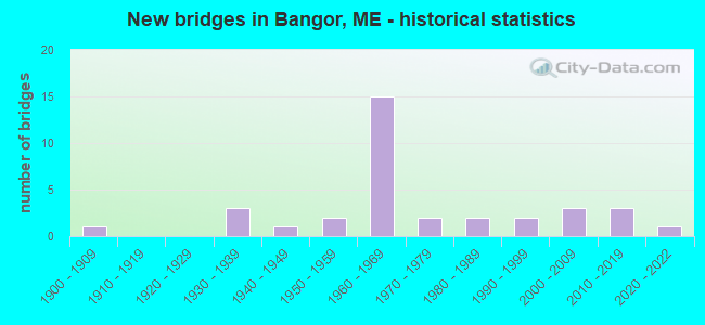
- New bridges - historical statistics
- 11900-1909
- 31930-1939
- 11940-1949
- 21950-1959
- 151960-1969
- 21970-1979
- 21980-1989
- 21990-1999
- 32000-2009
- 32010-2019
- 12020-2022
FCC Registered Antenna Towers: 111 (See the full list of FCC Registered Antenna Towers)
FCC Registered Commercial Land Mobile Towers: 5 (See the full list of FCC Registered Commercial Land Mobile Towers in Bangor, ME)
FCC Registered Private Land Mobile Towers: 1 (See the full list of FCC Registered Private Land Mobile Towers)
FCC Registered Broadcast Land Mobile Towers: 61 (See the full list of FCC Registered Broadcast Land Mobile Towers)
FCC Registered Microwave Towers: 63 (See the full list of FCC Registered Microwave Towers in this town)
FCC Registered Paging Towers: 4 (See the full list of FCC Registered Paging Towers)
FCC Registered Maritime Coast & Aviation Ground Towers: 26 (See the full list of FCC Registered Maritime Coast & Aviation Ground Towers)
FCC Registered Amateur Radio Licenses: 217 (See the full list of FCC Registered Amateur Radio Licenses in Bangor)
FAA Registered Aircraft Manufacturers and Dealers: 1 (See the full list of FAA Registered Manufacturers and Dealers in Bangor)
FAA Registered Aircraft: 60 (See the full list of FAA Registered Aircraft)
| Home Mortgage Disclosure Act Aggregated Statistics For Year 2009 (Based on 9 full tracts) | ||||||||||||||
| A) FHA, FSA/RHS & VA Home Purchase Loans | B) Conventional Home Purchase Loans | C) Refinancings | D) Home Improvement Loans | E) Loans on Dwellings For 5+ Families | F) Non-occupant Loans on < 5 Family Dwellings (A B C & D) | G) Loans On Manufactured Home Dwelling (A B C & D) | ||||||||
|---|---|---|---|---|---|---|---|---|---|---|---|---|---|---|
| Number | Average Value | Number | Average Value | Number | Average Value | Number | Average Value | Number | Average Value | Number | Average Value | Number | Average Value | |
| LOANS ORIGINATED | 169 | $129,083 | 183 | $126,880 | 485 | $136,992 | 69 | $47,130 | 8 | $853,000 | 77 | $104,727 | 7 | $23,286 |
| APPLICATIONS APPROVED, NOT ACCEPTED | 10 | $165,300 | 14 | $116,500 | 49 | $139,082 | 7 | $199,429 | 0 | $0 | 5 | $286,600 | 1 | $30,000 |
| APPLICATIONS DENIED | 31 | $105,452 | 25 | $137,320 | 146 | $148,260 | 33 | $48,030 | 1 | $420,000 | 16 | $107,312 | 4 | $38,250 |
| APPLICATIONS WITHDRAWN | 17 | $118,235 | 17 | $130,941 | 102 | $132,931 | 3 | $77,000 | 3 | $610,333 | 8 | $103,500 | 3 | $49,000 |
| FILES CLOSED FOR INCOMPLETENESS | 2 | $120,500 | 3 | $171,000 | 19 | $167,158 | 2 | $183,500 | 0 | $0 | 3 | $79,000 | 0 | $0 |
Detailed mortgage data for all 9 tracts in Bangor, ME
| Private Mortgage Insurance Companies Aggregated Statistics For Year 2009 (Based on 8 full tracts) | ||||||||
| A) Conventional Home Purchase Loans | B) Refinancings | C) Non-occupant Loans on < 5 Family Dwellings (A & B) | D) Loans On Manufactured Home Dwelling (A & B) | |||||
|---|---|---|---|---|---|---|---|---|
| Number | Average Value | Number | Average Value | Number | Average Value | Number | Average Value | |
| LOANS ORIGINATED | 19 | $130,000 | 19 | $163,947 | 1 | $50,000 | 0 | $0 |
| APPLICATIONS APPROVED, NOT ACCEPTED | 7 | $249,286 | 5 | $158,800 | 0 | $0 | 0 | $0 |
| APPLICATIONS DENIED | 2 | $147,000 | 2 | $121,500 | 0 | $0 | 1 | $95,000 |
| APPLICATIONS WITHDRAWN | 1 | $123,000 | 2 | $114,000 | 0 | $0 | 0 | $0 |
| FILES CLOSED FOR INCOMPLETENESS | 0 | $0 | 0 | $0 | 0 | $0 | 0 | $0 |
2002 - 2018 National Fire Incident Reporting System (NFIRS) incidents
- Fire incident types reported to NFIRS in Bangor, ME
- 1,24245.0%Structure Fires
- 92933.7%Outside Fires
- 35512.9%Mobile Property/Vehicle Fires
- 2328.4%Other
 Based on the data from the years 2002 - 2018 the average number of fires per year is 162. The highest number of reported fires - 228 took place in 2010, and the least - 3 in 2017. The data has an increasing trend.
 When looking into fire subcategories, the most reports belonged to: Structure Fires (45.0%), and Outside Fires (33.7%).
Fire-safe hotels and motels in Bangor, Maine:
- Best Western White House Inn, 155 Littlefield Ave, Bangor, Maine 04401 , Phone: (207) 862-3737, Fax: (207) 862-3737
- Quality Inn, 750 Hogan Rd, Bangor, Maine 04401 , Phone: (207) 942-7899, Fax: (207) 942-6463
- The Charles Inn, 20 Broad St, Bangor, Maine 04401 , Phone: (207) 992-2820, Fax: (207) 992-2826
- Holiday Inn, 404 Odlin Rd, Bangor, Maine 04401 , Phone: (207) 947-0101, Fax: (207) 947-7619
- Comfort Inn, 10 Bangor Mall Blvd, Bangor, Maine 04401 , Phone: (207) 990-0888, Fax: (207) 990-0577
- Bangor Historic Track, Inc (dba Hollywood Slots Hotel & Raceway), 500 Main St, Bangor, Maine 04401 , Phone: (207) 974-6100
- Hilton Garden Inn, 250 Haskell Rd, Bangor, Maine 04401 , Phone: (207) 262-0099, Fax: (207) 947-6809
- Hampton Inn, 261 Haskell Rd, Bangor, Maine 04401 , Phone: (207) 990-4400, Fax: (207) 262-9400
- 5 other hotels and motels
| Most common first names in Bangor, ME among deceased individuals | ||
| Name | Count | Lived (average) |
|---|---|---|
| Mary | 369 | 80.1 years |
| John | 331 | 74.2 years |
| George | 222 | 75.5 years |
| James | 221 | 71.7 years |
| William | 220 | 74.7 years |
| Robert | 205 | 68.9 years |
| Charles | 195 | 75.6 years |
| Helen | 178 | 80.3 years |
| Margaret | 169 | 81.5 years |
| Ruth | 143 | 80.3 years |
| Most common last names in Bangor, ME among deceased individuals | ||
| Last name | Count | Lived (average) |
|---|---|---|
| Smith | 170 | 77.2 years |
| Brown | 98 | 76.5 years |
| Clark | 69 | 73.7 years |
| Davis | 68 | 77.3 years |
| Robinson | 64 | 78.6 years |
| White | 61 | 76.1 years |
| Grant | 52 | 79.8 years |
| King | 49 | 73.7 years |
| Jones | 44 | 76.1 years |
| Kelley | 44 | 78.1 years |
- 64.6%Fuel oil, kerosene, etc.
- 14.8%Utility gas
- 7.6%Electricity
- 7.1%Bottled, tank, or LP gas
- 4.4%Wood
- 1.4%Other fuel
- 39.3%Fuel oil, kerosene, etc.
- 26.2%Utility gas
- 22.3%Electricity
- 7.6%Bottled, tank, or LP gas
- 2.5%No fuel used
- 1.9%Other fuel
- 0.3%Solar energy
Bangor compared to Maine state average:
- Unemployed percentage below state average.
- Black race population percentage above state average.
- Median age below state average.
- Renting percentage above state average.
- Length of stay since moving in above state average.
- Institutionalized population percentage above state average.
Bangor on our top lists:
- #11 on the list of "Top 101 cities with the largest racial income disparity between any two races with at least 200 householders"
- #46 on the list of "Top 101 cities with the largest percentage of people in job corps and vocational training facilities (population 1,000+)"
- #55 on the list of "Top 101 cities with the biggest local government total salary and wages expenses per resident (population 10,000+)"
- #60 on the list of "Top 101 cities with the biggest property tax revenues per resident (population 10,000+)"
- #98 (04444) on the list of "Top 101 zip codes with the largest percentage of Scottish first ancestries (pop 5,000+)"
- #26 on the list of "Top 101 counties with the highest percentage of residents that smoked 100+ cigarettes in their lives"
- #27 on the list of "Top 101 counties with the highest percentage of residents that drank alcohol in the past 30 days"
- #28 on the list of "Top 101 counties with highest percentage of residents voting for 3rd party candidates in the 2012 Presidential Election (pop. 50,000+)"
- #42 on the list of "Top 101 counties with the lowest number of births per 1000 residents 2007-2013"
- #44 on the list of "Top 101 counties with the lowest percentage of residents relocating to foreign countries in 2011 (pop. 50,000+)"

|
|
Total of 90 patent applications in 2008-2024.