Leroy, Wisconsin
Submit your own pictures of this town and show them to the world
- OSM Map
- Google Map
- MSN Map
Population change since 2000: -10.2%
 |
| Males: 528 | |
| Females: 474 |
| Median resident age: | 43.3 years |
| Wisconsin median age: | 42.6 years |
Zip codes: 53006.
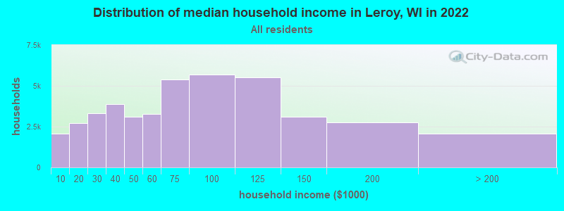
| Leroy: | $79,972 |
| WI: | $70,996 |
Estimated per capita income in 2022: $33,265 (it was $18,714 in 2000)
Leroy town income, earnings, and wages data
Estimated median house or condo value in 2022: $251,386 (it was $118,100 in 2000)
| Leroy: | $251,386 |
| WI: | $252,800 |
Mean prices in 2022: all housing units: $261,408; detached houses: $272,121; townhouses or other attached units: $256,767; in 2-unit structures: $201,412; in 3-to-4-unit structures: $189,678; in 5-or-more-unit structures: $177,084; mobile homes: $51,673
Detailed information about poverty and poor residents in Leroy, WI
Compare current foreclosures near Leroy, WI:
| Photo | Address | Area | Beds / Baths | Price | Details |
|---|---|---|---|---|---|

|
#1
Bauer Rd
Mayville, WI 53050
|
- sq. feet
|
- baths - beds |
show details | |

|
#2
N Pioneer Pkwy
Fond Du Lac, WI 54935
|
- sq. feet
|
- baths - beds |
show details | |

|
#3
Butternut Trl
Juneau, WI 53039
|
- sq. feet
|
- baths - beds |
show details | |

|
#4
W Division St
Fond Du Lac, WI 54935
|
- sq. feet
|
- baths - beds |
show details | |

|
#5
Heritage Hills Rd
Beaver Dam, WI 53916
|
- sq. feet
|
- baths - beds |
show details | |

|
#6
Ellis St
Fond Du Lac, WI 54935
|
- sq. feet
|
- baths - beds |
show details | |

|
#7
Lakeview
Fond Du Lac, WI 54937
|
- sq. feet
|
- baths - beds |
show details | |

|
#8
Maple Dr
Campbellsport, WI 53010
|
- sq. feet
|
- baths - beds |
show details | |

|
#9
Gemini Way
Fond Du Lac, WI 54937
|
- sq. feet
|
- baths - beds |
show details | |

|
#10
Gemini Way
Fond Du Lac, WI 54937
|
- sq. feet
|
- baths - beds |
show details |
| Photo | Address | Area | Beds / Baths | Price | Details |
|---|---|---|---|---|---|

|
#11
Jupiter Dr
Fond Du Lac, WI 54937
|
- sq. feet
|
- baths - beds |
show details | |

|
#12
N Butler St
Fond Du Lac, WI 54935
|
- sq. feet
|
- baths - beds |
show details | |

|
#13
Schulz Dr
Beaver Dam, WI 53916
|
- sq. feet
|
- baths - beds |
show details | |

|
#14
W 12th St
Fond Du Lac, WI 54935
|
- sq. feet
|
- baths - beds |
show details | |

|
#15
Louise Ln
Beaver Dam, WI 53916
|
- sq. feet
|
- baths - beds |
show details | |

|
#16
Sherwood Ave Apt 10
Fond Du Lac, WI 54935
|
- sq. feet
|
- baths - beds |
show details | |

|
#17
Sherwood Ave Apt 4
Fond Du Lac, WI 54935
|
- sq. feet
|
- baths - beds |
show details | |

|
#18
Riverside Ct # 3301
Fond Du Lac, WI 54935
|
- sq. feet
|
- baths - beds |
show details | |

|
#19
Center Rd, Apt B
Rosendale, WI 54974
|
- sq. feet
|
- baths - beds |
show details | |

|
#20
Country Aire Dr
Campbellsport, WI 53010
|
- sq. feet
|
- baths - beds |
show details |
| Photo | Address | Area | Beds / Baths | Price | Details |
|---|---|---|---|---|---|

|
#21
W Guindon Blvd
Fond Du Lac, WI 54935
|
- sq. feet
|
- baths - beds |
show details | |

|
#22
Harrison St # 15
Fond Du Lac, WI 54937
|
- sq. feet
|
- baths - beds |
show details | |

|
#23
4th St
Fond Du Lac, WI 54935
|
- sq. feet
|
- baths - beds |
show details | |

|
#24
Monroe St
Beaver Dam, WI 53916
|
- sq. feet
|
- baths - beds |
show details | |

|
#25
Main St
West Bend, WI 53090
|
- sq. feet
|
- baths - beds |
show details | |

|
#26
E Oak Grove St
Juneau, WI 53039
|
- sq. feet
|
- baths - beds |
show details | |

|
#27
Temperance St
Fond Du Lac, WI 54937
|
- sq. feet
|
- baths - beds |
show details | |

|
#28
W Scott St Apt 22
Fond Du Lac, WI 54937
|
- sq. feet
|
- baths - beds |
show details | |

|
#29
W Main St # 201
Brandon, WI 53919
|
- sq. feet
|
- baths - beds |
show details | |

|
#30
Woodland Dr # 4
Beaver Dam, WI 53916
|
- sq. feet
|
- baths - beds |
show details |
| Photo | Address | Area | Beds / Baths | Price | Details |
|---|---|---|---|---|---|

|
#31
Amory St # Lowr
Fond Du Lac, WI 54935
|
- sq. feet
|
- baths - beds |
show details | |

|
#32
Gaslight Dr
Fond Du Lac, WI 54937
|
- sq. feet
|
- baths - beds |
show details | |

|
#33
Lake George Ter
Beaver Dam, WI 53916
|
- sq. feet
|
- baths - beds |
show details | |

|
#34
Eagle Rd
Beaver Dam, WI 53916
|
- sq. feet
|
- baths - beds |
show details | |

|
#35
N Commercial St # 6
Brandon, WI 53919
|
- sq. feet
|
- baths - beds |
show details | |

|
#36
E 1st St Apt 110
Fond Du Lac, WI 54935
|
- sq. feet
|
- baths - beds |
show details | |

|
#37
Prairie Rd # 5
Fond Du Lac, WI 54935
|
- sq. feet
|
- baths - beds |
show details | |

|
#38
4th St # 4
Fond Du Lac, WI 54935
|
- sq. feet
|
- baths - beds |
show details | |

|
#39
Security Dr # Bd303
Fond Du Lac, WI 54935
|
- sq. feet
|
- baths - beds |
show details | |

|
#40
Twin Lakes Dr
Fond Du Lac, WI 54937
|
- sq. feet
|
- baths - beds |
show details |
| Photo | Address | Area | Beds / Baths | Price | Details |
|---|---|---|---|---|---|

|
#41
New Cassel
Campbellsport, WI 53010
|
- sq. feet
|
- baths - beds |
show details | |

|
#42
Kellom Rd, Lot 81
Beaver Dam, WI 53916
|
- sq. feet
|
- baths - beds |
show details | |

|
#43
Meadowbrook Park Dr
Iron Ridge, WI 53035
|
- sq. feet
|
- baths - beds |
show details | |

|
#44
Dairy Rd, Ste B
Mayville, WI 53050
|
- sq. feet
|
- baths - beds |
show details | |

|
#45
Meadowbrook Park Dr
Iron Ridge, WI 53035
|
- sq. feet
|
- baths - beds |
show details | |

|
#46
Vermont St
Beaver Dam, WI 53916
|
- sq. feet
|
- baths - beds |
show details | |

|
#47
S Main St # 9
Fond Du Lac, WI 54935
|
- sq. feet
|
- baths - beds |
show details | |

|
#48
Brookview Dr
Fond Du Lac, WI 54937
|
- sq. feet
|
- baths - beds |
show details | |

|
#49
Booth St, Apt 6
Fox Lake, WI 53933
|
- sq. feet
|
- baths - beds |
show details | |

|
Check over 1 million property listings on Foreclosure.com!
|
browse all offers | |||

- 97497.2%White alone
- 252.5%Hispanic
- 30.3%Asian alone
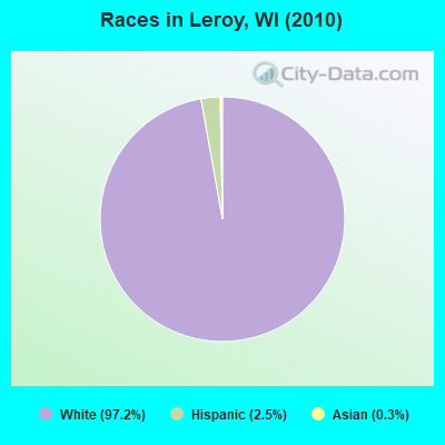
Races in Leroy detailed stats: ancestries, foreign born residents, place of birth
 Recent articles from our blog. Our writers, many of them Ph.D. graduates or candidates, create easy-to-read articles on a wide variety of topics.
Ancestries: German (71.9%), Polish (5.6%), Irish (5.2%), United States (5.2%), English (3.8%), Norwegian (1.9%).
Current Local Time: CST time zone
Land area: 36.6 square miles.
Population density: 27 people per square mile (very low).
10 residents are foreign born
| This town: | 0.9% |
| Wisconsin: | 3.6% |
| Leroy town: | 1.4% ($1,705) |
| Wisconsin: | 2.0% ($2,245) |
Nearest city with pop. 50,000+: Oshkosh, WI  (29.7 miles , pop. 62,916).
Nearest city with pop. 200,000+: Milwaukee, WI (48.7 miles , pop. 596,974).
Nearest city with pop. 1,000,000+: Chicago, IL (129.6 miles , pop. 2,896,016).
Nearest cities:
), ), ), ), Latitude: 43.60 N, Longitude: 88.57 W
Area code commonly used in this area: 920
| Here: | 2.3% |
| Wisconsin: | 2.7% |
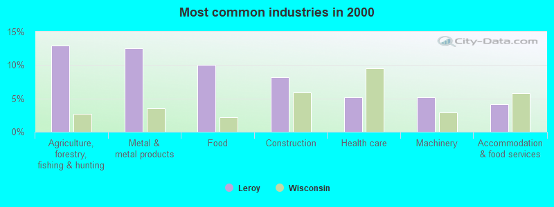
- Agriculture, forestry, fishing & hunting (13.0%)
- Metal & metal products (12.5%)
- Food (10.0%)
- Construction (8.2%)
- Health care (5.2%)
- Machinery (5.2%)
- Accommodation & food services (4.2%)
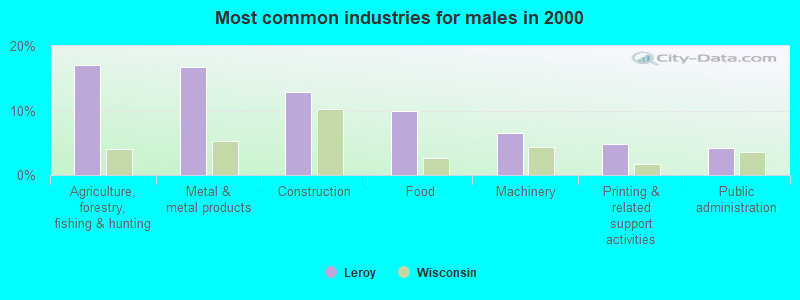
- Agriculture, forestry, fishing & hunting (17.1%)
- Metal & metal products (16.8%)
- Construction (12.9%)
- Food (9.9%)
- Machinery (6.6%)
- Printing & related support activities (4.8%)
- Public administration (4.2%)
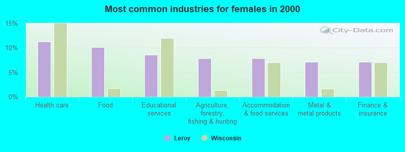
- Health care (11.2%)
- Food (10.1%)
- Educational services (8.6%)
- Agriculture, forestry, fishing & hunting (7.9%)
- Accommodation & food services (7.9%)
- Metal & metal products (7.1%)
- Finance & insurance (7.1%)

- Metal workers and plastic workers (9.7%)
- Other production occupations, including supervisors (9.3%)
- Farmers and farm managers (8.8%)
- Assemblers and fabricators (4.7%)
- Agricultural workers, including supervisors (4.2%)
- Building and grounds cleaning and maintenance occupations (3.8%)
- Driver/sales workers and truck drivers (3.8%)
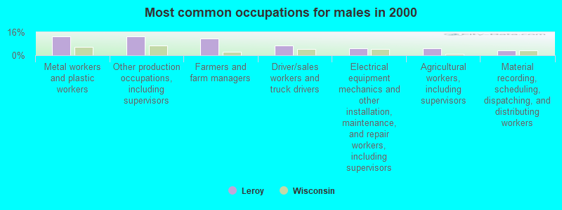
- Metal workers and plastic workers (13.2%)
- Other production occupations, including supervisors (12.9%)
- Farmers and farm managers (11.7%)
- Driver/sales workers and truck drivers (6.9%)
- Electrical equipment mechanics and other installation, maintenance, and repair workers, including supervisors (5.1%)
- Agricultural workers, including supervisors (4.8%)
- Material recording, scheduling, dispatching, and distributing workers (3.3%)
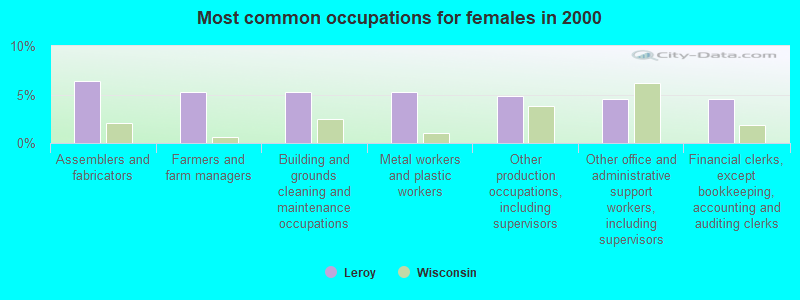
- Assemblers and fabricators (6.4%)
- Farmers and farm managers (5.2%)
- Building and grounds cleaning and maintenance occupations (5.2%)
- Metal workers and plastic workers (5.2%)
- Other production occupations, including supervisors (4.9%)
- Other office and administrative support workers, including supervisors (4.5%)
- Financial clerks, except bookkeeping, accounting and auditing clerks (4.5%)
Average climate in Leroy, Wisconsin
Based on data reported by over 4,000 weather stations


(lower is better)
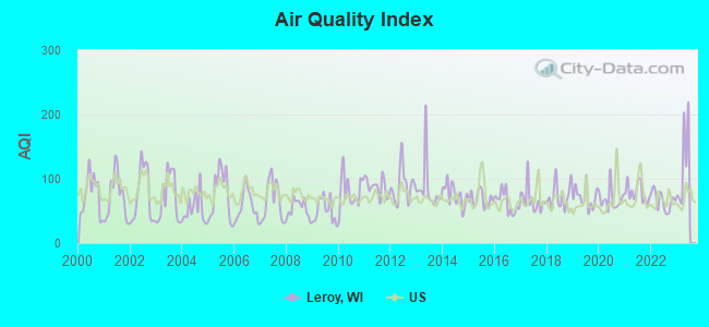
Air Quality Index (AQI) level in 2022 was 66.1. This is about average.
| City: | 66.1 |
| U.S.: | 72.6 |
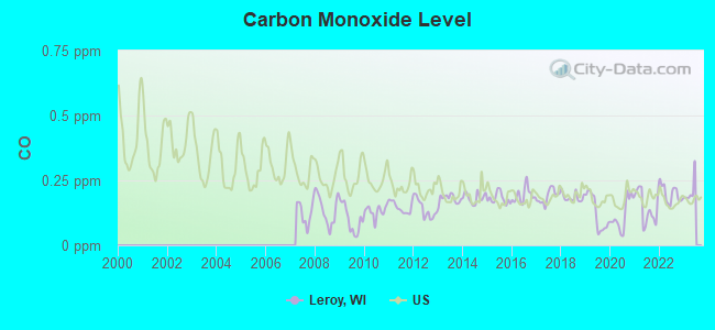
Carbon Monoxide (CO) [ppm] level in 2022 was 0.198. This is better than average. Closest monitor was 9.3 miles away from the city center.
| City: | 0.198 |
| U.S.: | 0.251 |
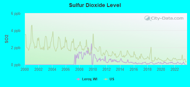
Sulfur Dioxide (SO2) [ppb] level in 2022 was 0.173. This is significantly better than average. Closest monitor was 8.0 miles away from the city center.
| City: | 0.173 |
| U.S.: | 1.515 |
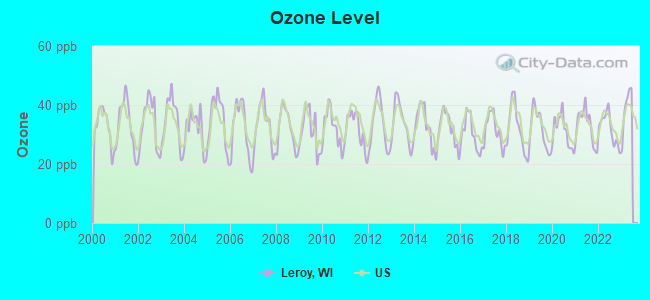
Ozone [ppb] level in 2022 was 31.9. This is about average. Closest monitor was 9.3 miles away from the city center.
| City: | 31.9 |
| U.S.: | 33.3 |
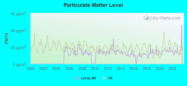
Particulate Matter (PM10) [µg/m3] level in 2022 was 14.1. This is better than average. Closest monitor was 9.3 miles away from the city center.
| City: | 14.1 |
| U.S.: | 19.2 |

Particulate Matter (PM2.5) [µg/m3] level in 2022 was 7.50. This is about average. Closest monitor was 9.3 miles away from the city center.
| City: | 7.50 |
| U.S.: | 8.11 |
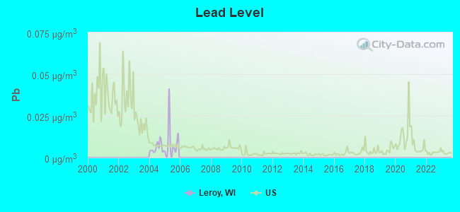
Lead (Pb) [µg/m3] level in 2005 was 0.0105. This is about average. Closest monitor was 11.3 miles away from the city center.
| City: | 0.0105 |
| U.S.: | 0.0093 |
Tornado activity:
Leroy-area historical tornado activity is slightly above Wisconsin state average. It is 59% greater than the overall U.S. average.
On 7/18/1996, a category F5 (max. wind speeds 261-318 mph) tornado 7.6 miles away from the Leroy town center injured 12 people and caused $40 million in damages.
On 4/21/1974, a category F4 (max. wind speeds 207-260 mph) tornado 16.8 miles away from the town center injured 35 people and caused between $500,000 and $5,000,000 in damages.
Earthquake activity:
Leroy-area historical earthquake activity is significantly above Wisconsin state average. It is 6% greater than the overall U.S. average.On 4/18/2008 at 09:36:59, a magnitude 5.4 (5.1 MB, 4.8 MS, 5.4 MW, 5.2 MW, Class: Moderate, Intensity: VI - VII) earthquake occurred 357.6 miles away from Leroy center
On 6/28/2004 at 06:10:52, a magnitude 4.2 (4.2 MW, Depth: 6.2 mi, Class: Light, Intensity: IV - V) earthquake occurred 148.7 miles away from the city center
On 6/10/1987 at 23:48:54, a magnitude 5.1 (4.9 MB, 4.4 MS, 4.6 MS, 5.1 LG) earthquake occurred 332.2 miles away from the city center
On 4/18/2008 at 09:36:59, a magnitude 5.2 (5.2 MW, Depth: 8.9 mi) earthquake occurred 357.6 miles away from the city center
On 5/2/2015 at 16:23:07, a magnitude 4.2 (4.2 MW, Depth: 2.8 mi) earthquake occurred 184.9 miles away from Leroy center
On 2/10/2010 at 09:59:35, a magnitude 3.8 (3.8 MW, Depth: 6.2 mi, Class: Light, Intensity: II - III) earthquake occurred 112.6 miles away from Leroy center
Magnitude types: regional Lg-wave magnitude (LG), body-wave magnitude (MB), surface-wave magnitude (MS), moment magnitude (MW)
Natural disasters:
The number of natural disasters in Dodge County (12) is smaller than the US average (15).Major Disasters (Presidential) Declared: 9
Emergencies Declared: 3
Causes of natural disasters: Floods: 6, Storms: 6, Tornadoes: 4, Drought: 1, Hurricane: 1, Snow: 1, Snowstorm: 1, Wind: 1, Winter Storm: 1, Other: 1 (Note: some incidents may be assigned to more than one category).
Hospitals and medical centers near Leroy:
- HOPE HEALTH AND REHAB (Nursing Home, about 7 miles away; LOMIRA, WI)
- HOPE NURSING HOME INC (Nursing Home, about 7 miles away; LOMIRA, WI)
- MAYVILLE NUR REHAB CTR (Nursing Home, about 8 miles away; MAYVILLE, WI)
- CHRISTIAN HOME (Nursing Home, about 9 miles away; WAUPUN, WI)
- CHRISTIAN HOME AND REHAB CTR (Nursing Home, about 9 miles away; WAUPUN, WI)
- WAUPUN MEM HSPTL Critical Access Hospitals (about 10 miles away; WAUPUN, WI)
- WAUPUN MEMORIAL HOSPITAL (Hospital, about 10 miles away; WAUPUN, WI)
Colleges/universities with over 2000 students nearest to Leroy:
- Marian University (about 15 miles; Fond Du Lac, WI; Full-time enrollment: 2,045)
- Moraine Park Technical College (about 16 miles; Fond du Lac, WI; FT enrollment: 3,079)
- University of Wisconsin-Oshkosh (about 30 miles; Oshkosh, WI; FT enrollment: 10,637)
- Lakeland College (about 39 miles; Plymouth, WI; FT enrollment: 2,395)
- Waukesha County Technical College (about 40 miles; Pewaukee, WI; FT enrollment: 4,415)
- Concordia University-Wisconsin (about 41 miles; Mequon, WI; FT enrollment: 5,253)
- Carroll University (about 45 miles; Waukesha, WI; FT enrollment: 3,313)
Points of interest:
Notable locations in Leroy: Oechsner Farms (A), Crestledge Farms (B), Loduha Farm (C). Display/hide their locations on the map
Cemeteries: Tidyman Cemetery (1), Mount Pleasant Cemetery (2), Saint Paul Cemetery (3). Display/hide their locations on the map
River: West Branch Rock River (A). Display/hide its location on the map
Park in Leroy: Horicon National Wildlife Refuge (1). Display/hide its location on the map
| This town: | 2.6 people |
| Wisconsin: | 2.4 people |
| This town: | 75.2% |
| Whole state: | 64.4% |
| This town: | 4.4% |
| Whole state: | 7.3% |
Likely homosexual households (counted as self-reported same-sex unmarried-partner households)
- Lesbian couples: 0.5% of all households
- Gay men: 0.0% of all households
| This town: | 3.9% |
| Whole state: | 8.7% |
| This town: | 1.2% |
| Whole state: | 3.7% |
For population 15 years and over in Leroy:
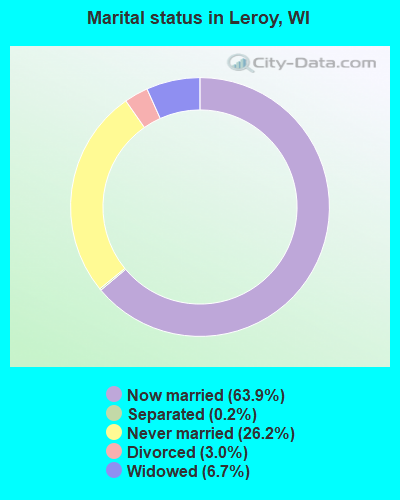
- Never married: 26.2%
- Now married: 63.9%
- Separated: 0.2%
- Widowed: 6.7%
- Divorced: 3.0%
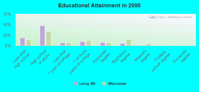
For population 25 years and over in Leroy:
- High school or higher: 81.1%
- Bachelor's degree or higher: 7.8%
- Graduate or professional degree: 2.1%
- Unemployed: 3.2%
- Mean travel time to work (commute): 20.0 minutes
| Here: | 10.0 |
| Wisconsin average: | 11.0 |
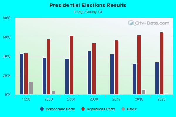
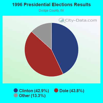
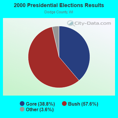
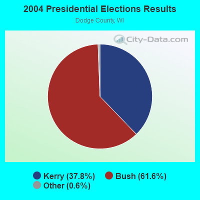
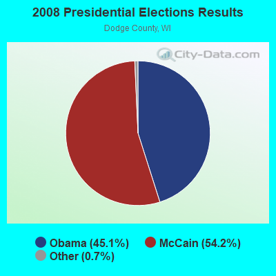
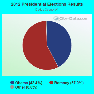
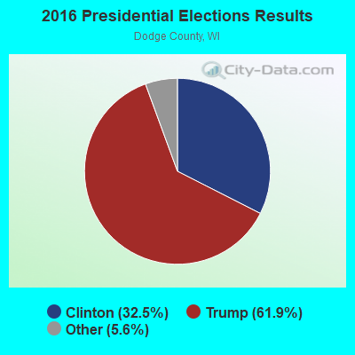
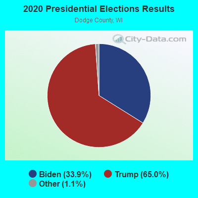
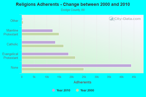
Graphs represent county-level data. Detailed 2008 Election Results
Religion statistics for Leroy, WI (based on Dodge County data)
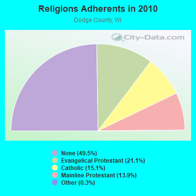
| Religion | Adherents | Congregations |
|---|---|---|
| Evangelical Protestant | 18,757 | 62 |
| Catholic | 13,437 | 13 |
| Mainline Protestant | 12,363 | 32 |
| Other | 265 | 2 |
| Orthodox | - | - |
| None | 43,937 | - |
Food Environment Statistics:
| Here: | 1.48 / 10,000 pop. |
| Wisconsin: | 1.86 / 10,000 pop. |
| Dodge County: | 3.76 / 10,000 pop. |
| State: | 4.12 / 10,000 pop. |
| This county: | 6.84 / 10,000 pop. |
| State: | 8.64 / 10,000 pop. |
| Here: | 7.3% |
| State: | 7.6% |
| This county: | 28.8% |
| State: | 27.5% |
| This county: | 8.1% |
| Wisconsin: | 13.0% |
Strongest AM radio stations in Leroy:
- WNAM (1280 AM; 50 kW; NEENAH-MENASHA, WI; Owner: CUMULUS LICENSING CORP.)
- WTMJ (620 AM; 50 kW; MILWAUKEE, WI; Owner: JOURNAL BROADCAST CORPORATION)
- WHBY (1150 AM; 25 kW; KIMBERLY, WI; Owner: WOODWARD COMMUNICATIONS, INC.)
- WFDL (1170 AM; daytime; 1 kW; WAUPUN, WI; Owner: RADIO PLUS, INC.)
- WISN (1130 AM; 50 kW; MILWAUKEE, WI; Owner: CAPSTAR TX LIMITED PARTNERSHIP)
- WRPN (1600 AM; 5 kW; RIPON, WI)
- WSPT (1010 AM; 50 kW; STEVENS POINT, WI)
- WGN (720 AM; 50 kW; CHICAGO, IL; Owner: WGN CONTINENTAL BROADCASTING CO.)
- WSCR (670 AM; 50 kW; CHICAGO, IL; Owner: INFINITY BROADCASTING OPERATIONS, INC.)
- WBBM (780 AM; 50 kW; CHICAGO, IL; Owner: INFINITY BROADCASTING OPERATIONS, INC.)
- WKSH (1640 AM; 10 kW; SUSSEX, WI; Owner: ABC, INC.)
- WAUK (1510 AM; daytime; 10 kW; WAUKESHA, WI; Owner: WALT-WEST WISCONSIN, INC.)
- KFIZ (1450 AM; 1 kW; FOND DU LAC, WI; Owner: RBH ENTERPRISES, INC.)
Strongest FM radio stations in Leroy:
- WFDL-FM (97.7 FM; LOMIRA, WI; Owner: RADIO PLUS OF FOND DU LAC, INC.)
- WMDC (98.7 FM; MAYVILLE, WI; Owner: RADIO PLUS, INC.)
- WBWI-FM (92.5 FM; WEST BEND, WI; Owner: WEST BEND BROADCASTING CO.)
- WTCX (96.1 FM; RIPON, WI; Owner: RADIO B/C LTD PARTNERSHIP)
- WXRO (95.3 FM; BEAVER DAM, WI; Owner: GOOD KARMA BROADCASTING, L.L.C.)
- WPKR (99.5 FM; OMRO, WI; Owner: MIDWEST DIMENSIONS, INC.)
- WAPL-FM (105.7 FM; APPLETON, WI; Owner: WOODWARD COMMUNICATIONS, INC.)
- WSTM (91.3 FM; KIEL, WI; Owner: JUBILATION MINISTRIES INC)
- KFIZ-FM (107.1 FM; FOND DU LAC, WI; Owner: RBH ENTERPRISES, INC.)
- WTKM-FM (104.9 FM; HARTFORD, WI; Owner: KETTLE MORAINE B/CTING COMPANY, INC.)
- W236AG (95.1 FM; FOND DU LAC, WI; Owner: FAMILY EDUCATION BROADCASTING CORP.)
TV broadcast stations around Leroy:
- WWRS-TV (Channel 52; MAYVILLE, WI; Owner: NATIONAL MINORITY T.V., INC.)
- WMMF-TV (Channel 68; FOND DU LAC, WI; Owner: PAPPAS TELECASTING OF WISCONSIN, A CALIFORNIA LTD PARTNRSHP)
- WDJT-TV (Channel 58; MILWAUKEE, WI; Owner: WDJT-TV LIMITED PARTNERSHIP)
- WISN-TV (Channel 12; MILWAUKEE, WI; Owner: WISN HEARST-ARGYLE TV, INC. (CA CORP.))
- WITI (Channel 6; MILWAUKEE, WI; Owner: WITI LICENSE,INC.)
- WPXE (Channel 55; KENOSHA, WI; Owner: PAXSON MILWAUKEE LICENSE, INC.)
- WMVS (Channel 10; MILWAUKEE, WI; Owner: MILWAUKEE AREA TECHNICAL COLLEGE DISTRICT BOARD)
- WMVT (Channel 36; MILWAUKEE, WI; Owner: MILWAUKEE AREA TECHNICAL COLLEGE DISTRICT BOARD)
- WMLW-CA (Channel 46; MILWAUKEE, WI; Owner: CHANNEL 41 AND 63 LIMITED PARTNERSHIP)
- National Bridge Inventory (NBI) Statistics
- 3Number of bridges
- 23ft / 7.0mTotal length
- $164,000Total costs
- 1,566Total average daily traffic
- 28Total average daily truck traffic
- 1,721Total future (year 2039) average daily traffic
FCC Registered Microwave Towers:
1- Leroy Jenkins Wt, Lat: 43.574472 Lon: -88.561583, Type: Tank, Structure height: 42.7 m, Overall height: 43 m, Call Sign: WQJH835,
Assigned Frequencies: 3650.00 MHz, Grant Date: 09/16/2008, Expiration Date: 09/16/2018, Cancellation Date: 11/17/2018, Certifier: Mark E Dodge, Registrant: Granite Wireless, Inc., 300 Industrial Dr, Random Lake, WI 53075, Phone: (920) 994-2388, Email:
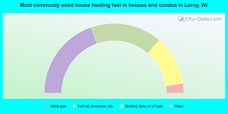
- 39.5%Utility gas
- 32.9%Fuel oil, kerosene, etc.
- 23.1%Bottled, tank, or LP gas
- 2.4%Wood
- 0.9%Solar energy
- 0.6%Electricity
- 0.6%Other fuel
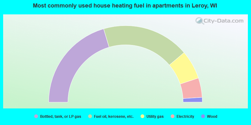
- 40.8%Bottled, tank, or LP gas
- 36.7%Fuel oil, kerosene, etc.
- 12.2%Utility gas
- 8.2%Electricity
- 2.0%Wood
Leroy compared to Wisconsin state average:
- Unemployed percentage significantly below state average.
- Black race population percentage significantly below state average.
- Hispanic race population percentage significantly below state average.
- Foreign-born population percentage significantly below state average.
- Renting percentage below state average.
- Length of stay since moving in significantly above state average.
- Number of rooms per house significantly below state average.
- House age significantly below state average.
- Percentage of population with a bachelor's degree or higher significantly below state average.