Little Colorado, Arizona
Submit your own pictures of this place and show them to the world
- OSM Map
- General Map
- Google Map
- MSN Map

| Males: 10,360 | |
| Females: 9,622 |
| Median resident age: | 30.5 years |
| Arizona median age: | 34.2 years |
Zip code: 86032
| Little Colorado: | $53,887 |
| AZ: | $74,568 |
Estimated per capita income in 2022: $27,317 (it was $12,901 in 2000)
Little Colorado CCD income, earnings, and wages data
Estimated median house or condo value in 2022: $186,156 (it was $60,000 in 2000)
| Little Colorado: | $186,156 |
| AZ: | $402,800 |
Mean prices in 2022: all housing units: $270,870; detached houses: $303,591; townhouses or other attached units: $455,253; in 3-to-4-unit structures: $254,269; in 5-or-more-unit structures: $298,694; mobile homes: $130,620; occupied boats, rvs, vans, etc.: $18,692
Little Colorado, AZ residents, houses, and apartments details
Detailed information about poverty and poor residents in Little Colorado, AZ


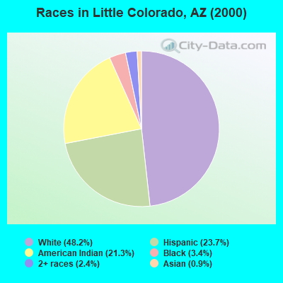
- 8,48548.2%White alone
- 4,18423.7%Hispanic
- 3,75521.3%American Indian alone
- 6013.4%Black alone
- 4172.4%Two or more races
- 1590.9%Asian alone
- 110.06%Native Hawaiian and Other
Pacific Islander alone - 80.05%Other race alone
 Recent articles from our blog. Our writers, many of them Ph.D. graduates or candidates, create easy-to-read articles on a wide variety of topics.
Current Local Time: MST (no DST) time zone
Land area: 1766.3 square miles.
Population density: 11 people per square mile (very low).
| Little Colorado CCD: | 0.7% ($441) |
| Arizona: | 0.9% ($962) |
Nearest city with pop. 50,000+: Coconino, AZ (63.7 miles  , pop. 74,488).
Nearest city with pop. 200,000+: Scottsdale, AZ (124.4 miles , pop. 202,705).
Nearest city with pop. 1,000,000+: Phoenix, AZ (134.6 miles , pop. 1,321,045).
Nearest cities:
), Latitude: 34.91 N, Longitude: 110.41 W
Area code commonly used in this area: 928

| Here: | 5.7% |
| Arizona: | 3.8% |
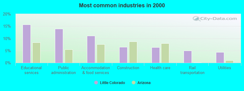
- Educational services (15.7%)
- Public administration (13.9%)
- Accommodation & food services (11.1%)
- Construction (6.4%)
- Health care (6.3%)
- Rail transportation (4.9%)
- Utilities (4.3%)
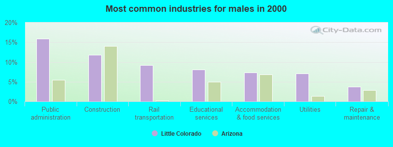
- Public administration (15.9%)
- Construction (11.8%)
- Rail transportation (9.2%)
- Educational services (8.1%)
- Accommodation & food services (7.3%)
- Utilities (7.1%)
- Repair & maintenance (3.8%)
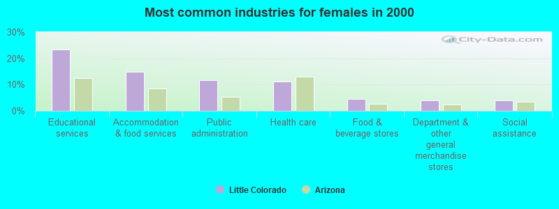
- Educational services (23.4%)
- Accommodation & food services (14.9%)
- Public administration (11.8%)
- Health care (11.3%)
- Food & beverage stores (4.6%)
- Department & other general merchandise stores (4.1%)
- Social assistance (3.9%)

- Law enforcement workers, including supervisors (6.3%)
- Preschool, kindergarten, elementary, and middle school teachers (5.1%)
- Other management occupations, except farmers and farm managers (4.0%)
- Rail and water transportation workers (3.8%)
- Other sales and related occupations, including supervisors (3.3%)
- Information and record clerks, except customer service representatives (3.2%)
- Building and grounds cleaning and maintenance occupations (3.2%)
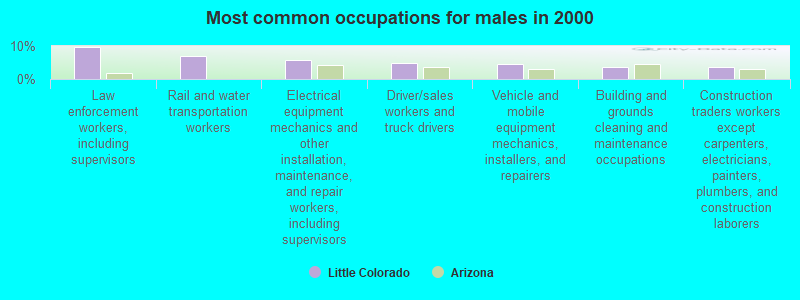
- Law enforcement workers, including supervisors (9.7%)
- Rail and water transportation workers (6.9%)
- Electrical equipment mechanics and other installation, maintenance, and repair workers, including supervisors (5.7%)
- Driver/sales workers and truck drivers (5.0%)
- Vehicle and mobile equipment mechanics, installers, and repairers (4.6%)
- Building and grounds cleaning and maintenance occupations (3.7%)
- Construction traders workers except carpenters, electricians, painters, plumbers, and construction laborers (3.6%)
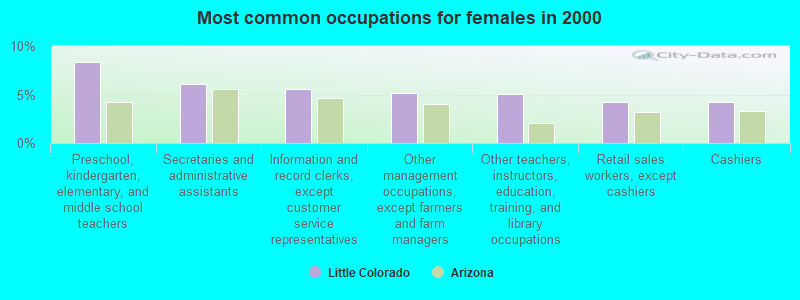
- Preschool, kindergarten, elementary, and middle school teachers (8.3%)
- Secretaries and administrative assistants (6.1%)
- Information and record clerks, except customer service representatives (5.6%)
- Other management occupations, except farmers and farm managers (5.2%)
- Other teachers, instructors, education, training, and library occupations (5.1%)
- Retail sales workers, except cashiers (4.2%)
- Cashiers (4.2%)
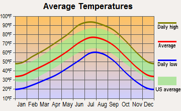
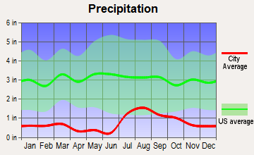
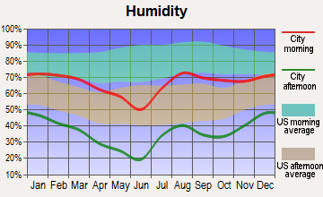
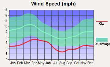
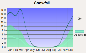
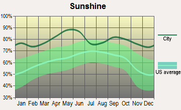
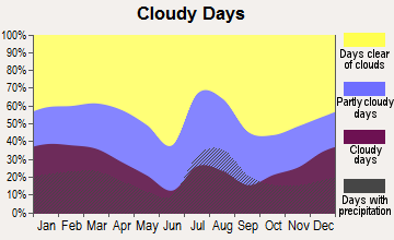
Average climate in Little Colorado, Arizona
Based on data reported by over 4,000 weather stations
Earthquake activity:
Little Colorado-area historical earthquake activity is significantly above Arizona state average. It is 1770% greater than the overall U.S. average.On 6/28/1992 at 11:57:34, a magnitude 7.6 (6.2 MB, 7.6 MS, 7.3 MW, Depth: 0.7 mi, Class: Major, Intensity: VIII - XII) earthquake occurred 352.2 miles away from Little Colorado center, causing 3 deaths (1 shaking deaths, 2 other deaths) and 400 injuries, causing $100,000,000 total damage and $40,000,000 insured losses
On 10/16/1999 at 09:46:44, a magnitude 7.4 (6.3 MB, 7.4 MS, 7.2 MW, 7.3 ML) earthquake occurred 343.5 miles away from Little Colorado center
On 5/19/1940 at 04:36:40, a magnitude 7.2 (7.2 UK) earthquake occurred 324.4 miles away from the city center, causing $33,000,000 total damage
On 12/31/1934 at 18:45:56, a magnitude 7.1 (7.1 UK) earthquake occurred 343.6 miles away from Little Colorado center
On 10/15/1979 at 23:16:54, a magnitude 7.0 (5.7 MB, 6.9 MS, 7.0 ML, 6.4 MW) earthquake occurred 333.2 miles away from Little Colorado center
On 7/21/1952 at 11:52:14, a magnitude 7.7 (7.7 UK) earthquake occurred 486.8 miles away from the city center, causing $50,000,000 total damage
Magnitude types: body-wave magnitude (MB), local magnitude (ML), surface-wave magnitude (MS), moment magnitude (MW)
Natural disasters:
The number of natural disasters in Navajo County (19) is greater than the US average (15).Major Disasters (Presidential) Declared: 10
Emergencies Declared: 3
Causes of natural disasters: Floods: 8, Storms: 7, Fires: 6, Winter Storms: 2, Drought: 1, Flash Flood: 1, Heavy Rain: 1, Hurricane: 1, Tornado: 1, Other: 1 (Note: some incidents may be assigned to more than one category).
Colleges/universities with over 2000 students nearest to Little Colorado:
- Coconino Community College (about 73 miles; Flagstaff, AZ; Full-time enrollment: 2,090)
- Northern Arizona University (about 74 miles; Flagstaff, AZ; FT enrollment: 22,494)
- Northcentral University (about 109 miles; Prescott Valley, AZ; FT enrollment: 5,927)
- Yavapai College (about 119 miles; Prescott, AZ; FT enrollment: 4,258)
- Paradise Valley Community College (about 126 miles; Phoenix, AZ; FT enrollment: 5,259)
- Scottsdale Community College (about 129 miles; Scottsdale, AZ; FT enrollment: 6,030)
- Universal Technical Institute of Arizona Inc-Motorcycle Mechanics Institute Division (about 130 miles; Phoenix, AZ; FT enrollment: 2,976)
Points of interest:
Notable locations in Little Colorado: Ortegas Ranch (A), Agate House (B), Aja Ranch (C), V K Windmill (D), Halfway Ranch (E), Mitchell Windmill (F), Black Rock Ranch (G), Borderland Trading Post (H), Rincon Ranch (I), Jeffers Ranch (J), Second Mesa Campground (K), Holbrook Country Club (L), Stone House (M), City of Holbrook Painted Mesa Water Reclamation Facility (N), City of Winslow Wastewater Treatment Plant (O), Fidel Windmill (P), Flake Windmill (Q), Cholla Power Generating Plant (R), Lerous Substation (S), Navajo County Fairgrounds (T). Display/hide their locations on the map
Shopping Centers: Holbrook Plaza Shopping Center (1), North Park Plaza Shopping Center (2). Display/hide their locations on the map
Churches in Little Colorado include: First United Methodist Church (A), First Christian Church (B), First Baptist Church of Winslow (C), First Assembly of God (D), Desert View Baptist Church (E), Calvary Chapel of Holbrook (F), Berean Baptist Church (G), Sun Valley Church of the Nazarene (H), Peace Lutheran Church (I). Display/hide their locations on the map
Cemeteries: Whipple Memorial Park (1), Sunset Cemetery (2). Display/hide their locations on the map
Lakes, reservoirs, and swamps: Carr Lake (A), Dry Lake (B), Woodruff Lake (C), Little Antelope Tank (D), Delaney Tank (E), Depot Tank (F), Dewey Tank (G), Dobell Tank (H). Display/hide their locations on the map
Streams, rivers, and creeks: Blairs Spring Wash (A), Dry Creek (B), Milky Wash (C), Rock Creek (D), Mexican Hollow Wash (E), Mesa Wash (F), Potato Wash (G), Digger Wash (H), Manila Wash (I). Display/hide their locations on the map
Parks in Little Colorado include: The Old Fort Historical Monument (1), Sunset Crossing (2), Winslow City Park (3), McHood Park (4), Hunt Park (5). Display/hide their locations on the map
| This place: | 2.9 people |
| Arizona: | 2.6 people |
| This place: | 52.0% |
| Whole state: | 68.2% |
| This place: | 6.2% |
| Whole state: | 6.2% |
Likely homosexual households (counted as self-reported same-sex unmarried-partner households)
- Lesbian couples: 0.3% of all households
- Gay men: 0.2% of all households
| This place: | 20.6% |
| Whole state: | 13.9% |
| This place: | 8.1% |
| Whole state: | 6.2% |
People in group quarters in Little Colorado in 2000:
- 1,363 people in state prisons
- 117 people in homes for abused, dependent, and neglected children
- 104 people in nursing homes
- 81 people in college dormitories (includes college quarters off campus)
- 65 people in unknown juvenile institutions
- 51 people in other noninstitutional group quarters
- 31 people in short-term care, detention or diagnostic centers for delinquent children
- 8 people in homes for the mentally retarded
- 4 people in wards in general hospitals for patients who have no usual home elsewhere
- 4 people in homes for the mentally ill
- 3 people in other group homes
For population 15 years and over in Little Colorado:
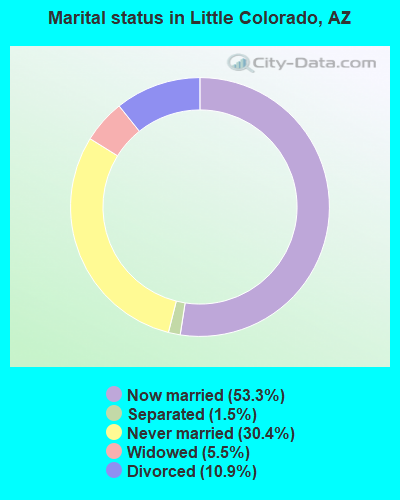
- Never married: 30.4%
- Now married: 53.3%
- Separated: 1.5%
- Widowed: 5.5%
- Divorced: 10.9%
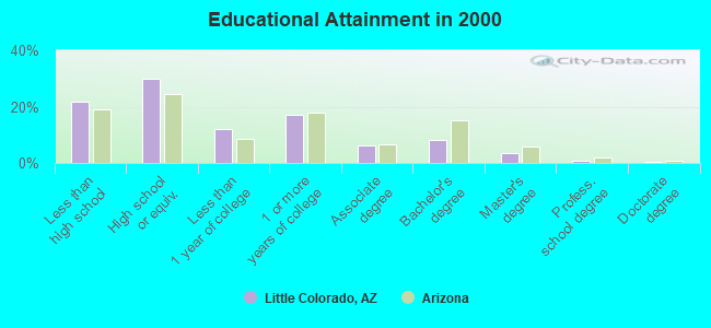
For population 25 years and over in Little Colorado:
- High school or higher: 78.3%
- Bachelor's degree or higher: 12.8%
- Graduate or professional degree: 4.8%
- Unemployed: 6.5%
- Mean travel time to work (commute): 14.8 minutes
| Here: | 11.1 |
| Arizona average: | 13.1 |
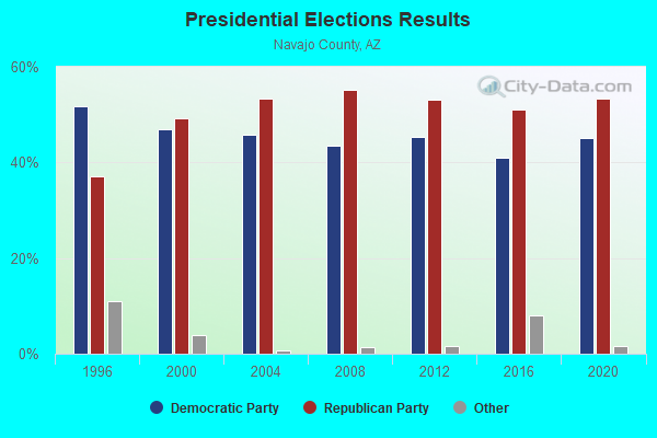
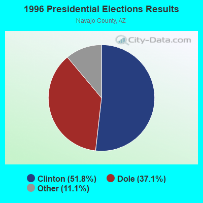
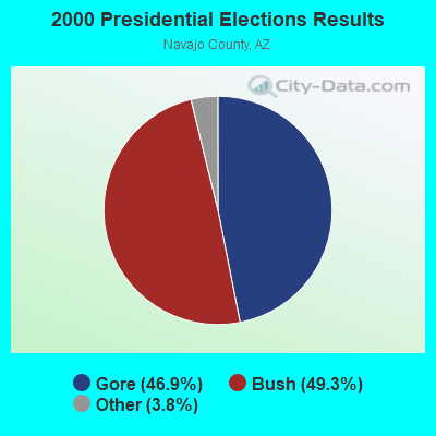
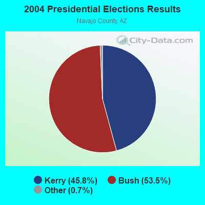
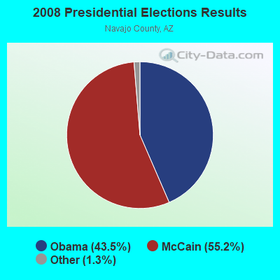
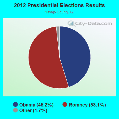
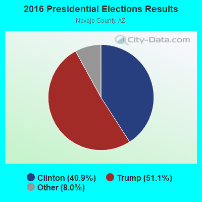
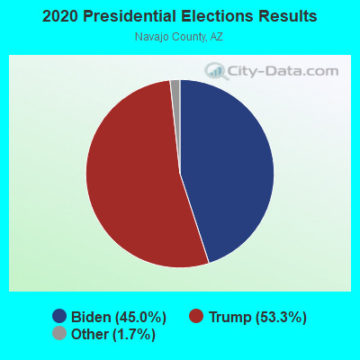
Graphs represent county-level data. Detailed 2008 Election Results
Religion statistics for Little Colorado, AZ (based on Navajo County data)

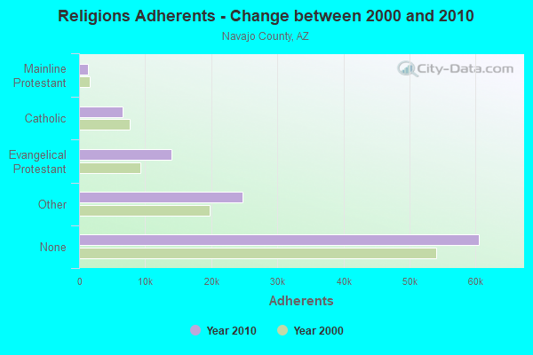
| Religion | Adherents | Congregations |
|---|---|---|
| Other | 24,727 | 62 |
| Evangelical Protestant | 13,966 | 98 |
| Catholic | 6,600 | 14 |
| Mainline Protestant | 1,410 | 18 |
| Black Protestant | 207 | 2 |
| None | 60,539 | - |
Food Environment Statistics:
| Here: | 1.71 / 10,000 pop. |
| Arizona: | 1.36 / 10,000 pop. |
| This county: | 0.09 / 10,000 pop. |
| Arizona: | 0.14 / 10,000 pop. |
| This county: | 0.27 / 10,000 pop. |
| Arizona: | 0.55 / 10,000 pop. |
| Here: | 4.95 / 10,000 pop. |
| Arizona: | 2.47 / 10,000 pop. |
| Navajo County: | 7.92 / 10,000 pop. |
| State: | 6.21 / 10,000 pop. |
| This county: | 12.7% |
| Arizona: | 8.0% |
| Navajo County: | 26.1% |
| Arizona: | 22.8% |
| Navajo County: | 9.8% |
| State: | 14.2% |
Strongest AM radio stations in Little Colorado:
- KDJI (1270 AM; 5 kW; HOLBROOK, AZ; Owner: PETRACOM OF HOLBROOK, L.L.C.)
- KTNN (660 AM; 50 kW; WINDOW ROCK, AZ; Owner: THE NAVAJO NATION)
- KHAC (880 AM; 43 kW; TSE BONITO, NM; Owner: WESTERN INDIAN MINISTRIES, INC.)
- KMIA (710 AM; 50 kW; BLACK CANYON CITY, AZ; Owner: ENTRAVISION HOLDINGS, LLC)
- KFNX (1100 AM; 50 kW; CAVE CREEK, AZ; Owner: NORTH AMERICAN BROADCASTING CO., INC.)
- KINO (1230 AM; 1 kW; WINSLOW, AZ; Owner: SUNFLOWER COMMUNICATIONS, INC.)
- KMIK (1580 AM; 50 kW; TEMPE, AZ; Owner: ABC, INC.)
- KFLT (830 AM; 50 kW; TUCSON, AZ; Owner: FAMILY LIFE B/CING SYSTEM, INC.)
- KPXQ (1360 AM; 50 kW; GLENDALE, AZ; Owner: COMMON GROUND BROADCASTING, INC.)
- KVWM (970 AM; 5 kW; SHOW LOW, AZ; Owner: PETRACOM OF SHOW LOW, LLC)
- KUAZ (1550 AM; daytime; 50 kW; TUCSON, AZ; Owner: ARIZONA BOARD OF REGENTS)
- KFNN (1510 AM; 22 kW; MESA, AZ; Owner: CRC BROADCASTING COMPANY, INC.)
- KAZM (780 AM; 5 kW; SEDONA, AZ; Owner: TABBACK BROADCASTING CO.)
Strongest FM radio stations in Little Colorado:
- KJKI (98.9 FM; LEUPP, AZ; Owner: ORAIBI MEDIA ASSOCIATION)
- KZUA (92.1 FM; HOLBROOK, AZ; Owner: PETRACOM OF HOLBROOK, L.L.C.)
- KBMH (90.3 FM; HOLBROOK, AZ; Owner: AMERICAN FAMILY ASSOCIATION)
TV broadcast stations around Little Colorado:
- K08HQ (Channel 8; CHINLE, AZ; Owner: KOB-TV, LLC)
- KPHZ (Channel 11; HOLBROOK, AZ; Owner: NBC TELEMUNDO PHOENIX, INC.)
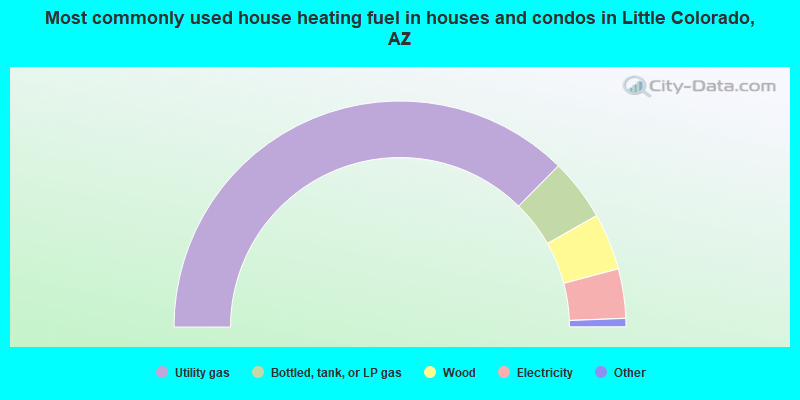
- 74.8%Utility gas
- 8.9%Bottled, tank, or LP gas
- 8.1%Wood
- 7.1%Electricity
- 0.7%Other fuel
- 0.3%No fuel used
- 0.2%Coal or coke
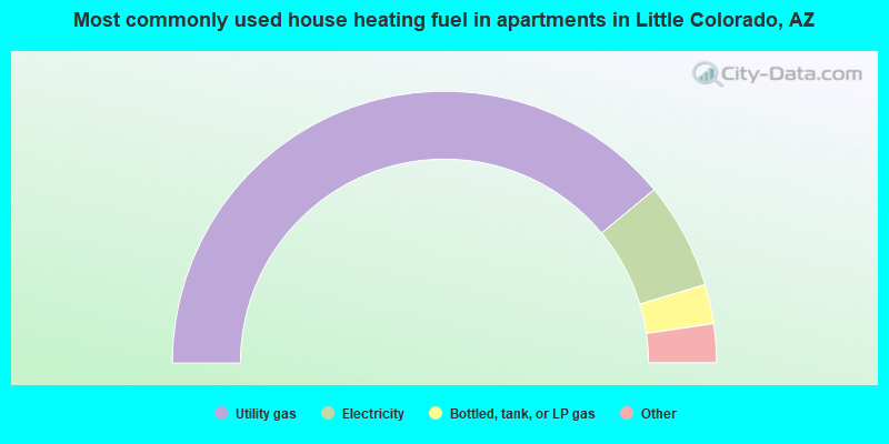
- 78.0%Utility gas
- 12.7%Electricity
- 4.7%Bottled, tank, or LP gas
- 3.8%Wood
- 0.8%No fuel used
Little Colorado compared to Arizona state average:
- Median house value below state average.
- Unemployed percentage below state average.
- Foreign-born population percentage significantly below state average.
- Renting percentage significantly below state average.
- Length of stay since moving in significantly above state average.
- Number of rooms per house significantly below state average.
- House age significantly below state average.
- Institutionalized population percentage significantly above state average.
- Percentage of population with a bachelor's degree or higher below state average.
Little Colorado on our top lists:
- #1 on the list of "Top 101 cities with largest percentage of males in occupations: rail and water transportation workers (population 5,000+)"
- #1 on the list of "Top 101 cities with largest percentage of males in industries: rail transportation (population 5,000+)"
- #7 on the list of "Top 101 cities with largest percentage of females in occupations: rail and water transportation workers (population 5,000+)"
- #9 on the list of "Top 101 cities with largest percentage of males in industries: gasoline stations (population 5,000+)"
- #15 on the list of "Top 101 cities with largest percentage of females in industries: rail transportation (population 5,000+)"
- #18 on the list of "Top 101 cities with largest percentage of females in occupations: plant and system operators (population 5,000+)"
- #34 on the list of "Top 101 cities with largest percentage of females in industries: gasoline stations (population 5,000+)"
- #36 on the list of "Top 101 cities with largest percentage of males in occupations: other construction workers and helpers (population 5,000+)"
- #36 on the list of "Top 101 cities with largest percentage of females in occupations: other teachers and instructors, education, training, and library occupations (population 5,000+)"
- #40 on the list of "Top 101 cities with the largest percentage of people in homes for abused, dependent, and neglected children (population 1,000+)"
- #56 on the list of "Top 101 cities with largest percentage of males in occupations: secondary school teachers (population 5,000+)"
- #62 on the list of "Top 100 cities with largest land areas"
- #63 on the list of "Top 101 cities with largest percentage of males in industries: utilities (population 5,000+)"
- #66 on the list of "Top 101 cities with largest percentage of females in industries: farm product raw materials merchant wholesalers (population 5,000+)"
- #84 on the list of "Top 101 cities with the largest percentage of people in unknown juvenile institutions (population 1,000+)"
- #97 on the list of "Top 100 most racially diverse cities (pop. 5,000+)"
- #21 on the list of "Top 101 counties with the largest increase in the number of deaths per 1000 residents 2000-2006 to 2007-2013 (pop. 50,000+)"
- #23 on the list of "Top 101 counties with the highest Ozone (1-hour) air pollution readings in 2012 (ppm)"