Madison, New Hampshire
Submit your own pictures of this town and show them to the world
- OSM Map
- General Map
- Google Map
- MSN Map
Population change since 2000: +26.1%
| Males: 1,265 | |
| Females: 1,237 |
| Median resident age: | 47.4 years |
| New Hampshire median age: | 43.9 years |
Zip codes: 03849.
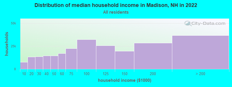
| Madison: | $83,069 |
| NH: | $89,992 |
Estimated per capita income in 2022: $46,259 (it was $20,608 in 2000)
Madison town income, earnings, and wages data
Estimated median house or condo value in 2022: $335,000 (it was $109,500 in 2000)
| Madison: | $335,000 |
| NH: | $384,700 |
Mean prices in 2022: all housing units: $505,201; detached houses: $542,950; townhouses or other attached units: $363,532; in 2-unit structures: $373,773; in 3-to-4-unit structures: $587,160; in 5-or-more-unit structures: $313,992; mobile homes: $113,714; occupied boats, rvs, vans, etc.: $118,400
Detailed information about poverty and poor residents in Madison, NH


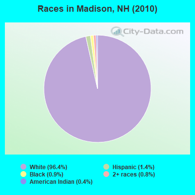
- 2,41196.4%White alone
- 361.4%Hispanic
- 230.9%Black alone
- 200.8%Two or more races
- 100.4%American Indian alone
- 20.08%Asian alone
Races in Madison detailed stats: ancestries, foreign born residents, place of birth
According to our research of New Hampshire and other state lists, there were 4 registered sex offenders living in Madison, New Hampshire as of April 28, 2024.
The ratio of all residents to sex offenders in Madison is 626 to 1.
The ratio of registered sex offenders to all residents in this city is lower than the state average.
Type |
2009 |
2010 |
2011 |
2012 |
2013 |
2014 |
2015 |
2016 |
2017 |
2018 |
2019 |
2020 |
2021 |
2022 |
|---|---|---|---|---|---|---|---|---|---|---|---|---|---|---|
| Murders (per 100,000) | 0 (0.0) | 0 (0.0) | 0 (0.0) | 0 (0.0) | 0 (0.0) | 0 (0.0) | 0 (0.0) | 0 (0.0) | 0 (0.0) | 0 (0.0) | 1 (38.3) | 0 (0.0) | 0 (0.0) | 0 (0.0) |
| Rapes (per 100,000) | 1 (42.8) | 1 (40.0) | 0 (0.0) | 1 (40.1) | 0 (0.0) | 0 (0.0) | 0 (0.0) | 0 (0.0) | 1 (39.6) | 0 (0.0) | 0 (0.0) | 0 (0.0) | 0 (0.0) | 0 (0.0) |
| Robberies (per 100,000) | 0 (0.0) | 0 (0.0) | 2 (79.8) | 0 (0.0) | 0 (0.0) | 0 (0.0) | 0 (0.0) | 1 (39.7) | 0 (0.0) | 0 (0.0) | 0 (0.0) | 0 (0.0) | 0 (0.0) | 0 (0.0) |
| Assaults (per 100,000) | 4 (171.0) | 2 (79.9) | 0 (0.0) | 0 (0.0) | 0 (0.0) | 0 (0.0) | 1 (39.7) | 2 (79.3) | 4 (158.5) | 0 (0.0) | 2 (76.5) | 3 (114.6) | 3 (113.4) | 1 (36.8) |
| Burglaries (per 100,000) | 19 (812.3) | 14 (559.6) | 7 (279.4) | 6 (240.4) | 11 (437.7) | 12 (475.2) | 9 (357.3) | 4 (158.7) | 10 (396.4) | 2 (78.1) | 3 (114.8) | 1 (38.2) | 2 (75.6) | 1 (36.8) |
| Thefts (per 100,000) | 27 (1,154) | 30 (1,199) | 27 (1,078) | 22 (881.4) | 30 (1,194) | 15 (594.1) | 13 (516.1) | 11 (436.3) | 11 (436.0) | 8 (312.4) | 25 (956.8) | 24 (916.7) | 11 (415.7) | 11 (404.9) |
| Auto thefts (per 100,000) | 1 (42.8) | 1 (40.0) | 2 (79.8) | 0 (0.0) | 3 (119.4) | 0 (0.0) | 0 (0.0) | 0 (0.0) | 2 (79.3) | 1 (39.0) | 0 (0.0) | 0 (0.0) | 1 (37.8) | 1 (36.8) |
| Arson (per 100,000) | 0 (0.0) | 0 (0.0) | 9 (359.3) | 0 (0.0) | 0 (0.0) | 0 (0.0) | 0 (0.0) | 1 (39.7) | 0 (0.0) | 1 (39.0) | 0 (0.0) | 0 (0.0) | 0 (0.0) | 0 (0.0) |
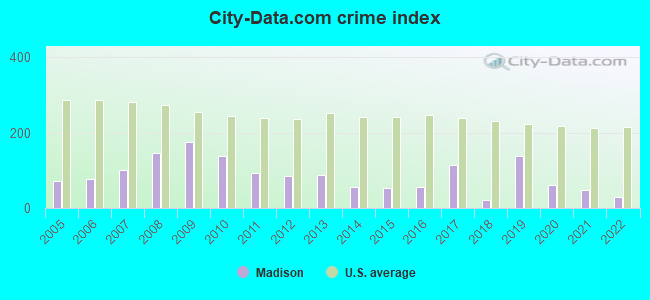
| City-Data.com crime index | 174.9 | 138.3 | 93.0 | 84.1 | 87.9 | 57.0 | 53.6 | 56.3 | 114.9 | 21.1 | 138.2 | 62.3 | 47.6 | 29.1 |
The City-Data.com crime index weighs serious crimes and violent crimes more heavily. Higher means more crime, U.S. average is 246.1. It adjusts for the number of visitors and daily workers commuting into cities.
Crime rate in Madison detailed stats: murders, rapes, robberies, assaults, burglaries, thefts, arson
Full-time law enforcement employees in 2021, including police officers: 4 (4 officers - 4 male; 0 female).
| Officers per 1,000 residents here: | 1.51 |
| New Hampshire average: | 2.14 |
 Recent articles from our blog. Our writers, many of them Ph.D. graduates or candidates, create easy-to-read articles on a wide variety of topics.

 | Well NH, it's been fun.. (164 replies) |
| Which of these towns do you think would check our boxes?? (19 replies) |
| West Coast to East Coast - Living Inquiry (57 replies) |
| Freedom, NH - looking for similar towns? (12 replies) |
| Any reason not to live in Madison? (2 replies) |
| Love everything about this state but... (130 replies) |
Latest news from Madison, NH collected exclusively by city-data.com from local newspapers, TV, and radio stations
Ancestries: English (30.0%), Irish (21.2%), French (12.8%), German (9.6%), Scottish (9.0%), Italian (8.3%).
Current Local Time: EST time zone
Incorporated in 1852
Elevation: 673 feet
Land area: 38.7 square miles.
Population density: 65 people per square mile (very low).
30 residents are foreign born
| This town: | 1.5% |
| New Hampshire: | 4.4% |
| Madison town: | 1.6% ($1,801) |
| New Hampshire: | 2.3% ($2,946) |
Nearest city with pop. 50,000+: Portland, ME  (47.1 miles , pop. 64,249).
Nearest city with pop. 200,000+: Boston, MA (109.3 miles , pop. 589,141).
Nearest city with pop. 1,000,000+: Bronx, NY (252.8 miles , pop. 1,332,650).
Nearest cities:
), ), ), ), )Latitude: 43.90 N, Longitude: 71.15 W
Area code: 603

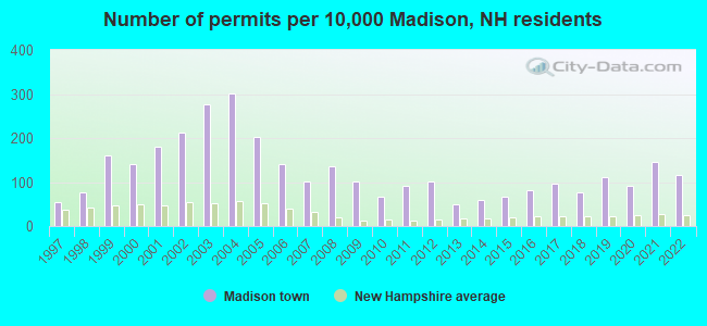
Single-family new house construction building permits:
- 2022: 23 buildings, average cost: $343,600
- 2021: 29 buildings, average cost: $296,900
- 2020: 18 buildings, average cost: $216,800
- 2019: 22 buildings, average cost: $231,400
- 2018: 15 buildings, average cost: $181,800
- 2017: 19 buildings, average cost: $239,000
- 2016: 16 buildings, average cost: $244,400
- 2015: 13 buildings, average cost: $281,400
- 2014: 12 buildings, average cost: $220,400
- 2013: 10 buildings, average cost: $211,000
- 2012: 20 buildings, average cost: $194,500
- 2011: 18 buildings, average cost: $239,700
- 2010: 13 buildings, average cost: $256,900
- 2009: 20 buildings, average cost: $303,900
- 2008: 27 buildings, average cost: $240,800
- 2007: 20 buildings, average cost: $183,200
- 2006: 28 buildings, average cost: $204,100
- 2005: 40 buildings, average cost: $159,200
- 2004: 60 buildings, average cost: $147,500
- 2003: 55 buildings, average cost: $139,100
- 2002: 42 buildings, average cost: $127,400
- 2001: 36 buildings, average cost: $118,000
- 2000: 28 buildings, average cost: $118,300
- 1999: 32 buildings, average cost: $93,200
- 1998: 15 buildings, average cost: $95,900
- 1997: 11 buildings, average cost: $98,800

| Here: | 2.2% |
| New Hampshire: | 2.5% |
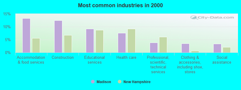
- Accommodation & food services (13.2%)
- Construction (12.5%)
- Educational services (9.2%)
- Health care (7.5%)
- Professional, scientific, technical services (3.8%)
- Clothing & accessories, including shoe, stores (3.5%)
- Social assistance (3.4%)
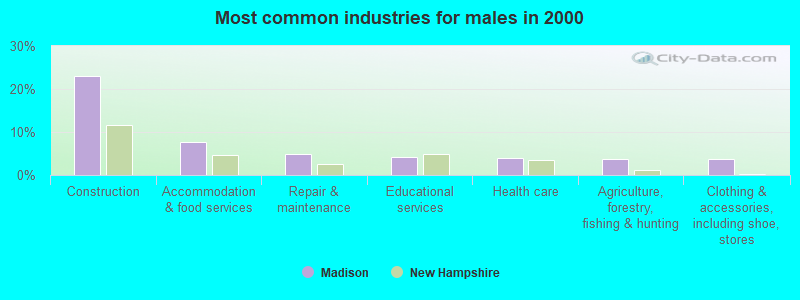
- Construction (23.1%)
- Accommodation & food services (7.7%)
- Repair & maintenance (5.0%)
- Educational services (4.1%)
- Health care (3.9%)
- Agriculture, forestry, fishing & hunting (3.8%)
- Clothing & accessories, including shoe, stores (3.8%)
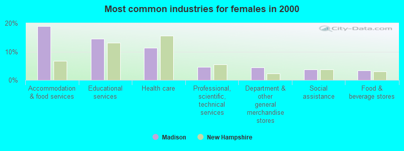
- Accommodation & food services (18.9%)
- Educational services (14.5%)
- Health care (11.2%)
- Professional, scientific, technical services (4.6%)
- Department & other general merchandise stores (4.5%)
- Social assistance (3.8%)
- Food & beverage stores (3.4%)
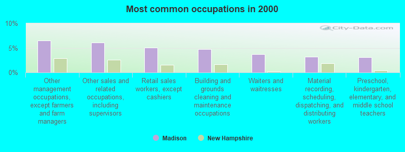
- Other management occupations, except farmers and farm managers (6.5%)
- Other sales and related occupations, including supervisors (6.0%)
- Retail sales workers, except cashiers (5.1%)
- Building and grounds cleaning and maintenance occupations (4.7%)
- Waiters and waitresses (3.7%)
- Material recording, scheduling, dispatching, and distributing workers (3.2%)
- Preschool, kindergarten, elementary, and middle school teachers (3.1%)
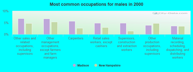
- Other sales and related occupations, including supervisors (6.8%)
- Other management occupations, except farmers and farm managers (6.7%)
- Carpenters (5.7%)
- Retail sales workers, except cashiers (4.8%)
- Supervisors, construction and extraction workers (4.8%)
- Other production occupations, including supervisors (3.9%)
- Material recording, scheduling, dispatching, and distributing workers (3.6%)
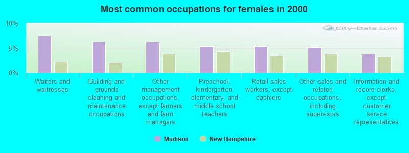
- Waiters and waitresses (7.5%)
- Building and grounds cleaning and maintenance occupations (6.2%)
- Other management occupations, except farmers and farm managers (6.2%)
- Preschool, kindergarten, elementary, and middle school teachers (5.4%)
- Retail sales workers, except cashiers (5.4%)
- Other sales and related occupations, including supervisors (5.2%)
- Information and record clerks, except customer service representatives (3.9%)
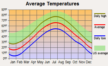
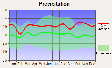
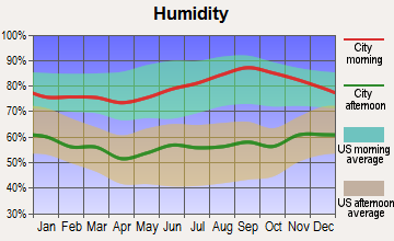
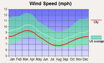
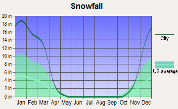
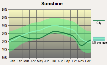
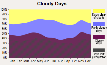
Average climate in Madison, New Hampshire
Based on data reported by over 4,000 weather stations
Tornado activity:
Madison-area historical tornado activity is below New Hampshire state average. It is 73% smaller than the overall U.S. average.
On 7/18/1963, a category F2 (max. wind speeds 113-157 mph) tornado 20.9 miles away from the Madison town center caused between $5000 and $50,000 in damages.
On 6/22/1981, a category F2 tornado 32.6 miles away from the town center caused between $500,000 and $5,000,000 in damages.
Earthquake activity:
Madison-area historical earthquake activity is significantly above New Hampshire state average. It is 73% smaller than the overall U.S. average.On 4/20/2002 at 10:50:47, a magnitude 5.3 (5.3 ML, Depth: 3.0 mi, Class: Moderate, Intensity: VI - VII) earthquake occurred 133.0 miles away from Madison center
On 4/20/2002 at 10:50:47, a magnitude 5.2 (5.2 MB, 4.2 MS, 5.2 MW, 5.0 MW) earthquake occurred 133.4 miles away from the city center
On 10/7/1983 at 10:18:46, a magnitude 5.3 (5.1 MB, 5.3 LG, 5.1 ML) earthquake occurred 158.8 miles away from Madison center
On 10/16/2012 at 23:12:25, a magnitude 4.7 (4.7 ML, Depth: 10.0 mi, Class: Light, Intensity: IV - V) earthquake occurred 32.6 miles away from Madison center
On 1/19/1982 at 00:14:42, a magnitude 4.7 (4.5 MB, 4.7 MD, 4.5 LG) earthquake occurred 35.6 miles away from Madison center
On 8/21/1996 at 07:54:14, a magnitude 3.8 (3.8 LG, 3.6 LG, Depth: 6.2 mi, Class: Light, Intensity: II - III) earthquake occurred 21.9 miles away from the city center
Magnitude types: regional Lg-wave magnitude (LG), body-wave magnitude (MB), duration magnitude (MD), local magnitude (ML), surface-wave magnitude (MS), moment magnitude (MW)
Natural disasters:
The number of natural disasters in Carroll County (29) is a lot greater than the US average (15).Major Disasters (Presidential) Declared: 17
Emergencies Declared: 9
Causes of natural disasters: Storms: 12, Floods: 11, Winter Storms: 5, Hurricanes: 4, Snows: 4, Snowstorms: 2, Blizzard: 1, Heavy Rain: 1, Ice Storm: 1, Snowfall: 1, Tornado: 1, Tropical Storm: 1, Wind: 1, Other: 1 (Note: some incidents may be assigned to more than one category).

Hospitals and medical centers near Madison:
- MERRIMAN HOUSE (Nursing Home, about 7 miles away; NORTH CONWAY, NH)
- MINERAL SPRINGS OF NORTH CONWAY CARE AND REHABILIT (Nursing Home, about 7 miles away; NORTH CONWAY, NH)
- VN AND HSP CARE SVC OF N CAR CTY (Home Health Center, about 11 miles away; NORTH CONWAY, NH)
- HICKS NURSING HOME (Nursing Home, about 12 miles away; FRYEBURG, ME)
- FRYEBURG HEALTH CARE CENTER (Nursing Home, about 13 miles away; FRYEBURG, ME)
- MOUNTAIN VIEW NURSING HOME (Nursing Home, about 15 miles away; OSSIPEE, NH)
- MOULTONBORO VNS (Home Health Center, about 16 miles away; MOULTONBOROUGH, NH)
Colleges/universities with over 2000 students nearest to Madison:
- Plymouth State University (about 29 miles; Plymouth, NH; Full-time enrollment: 4,838)
- Saint Joseph's College of Maine (about 34 miles; Standish, ME; FT enrollment: 2,010)
- University of Southern Maine (about 47 miles; Portland, ME; FT enrollment: 6,647)
- University of New England (about 50 miles; Biddeford, ME; FT enrollment: 4,539)
- Southern Maine Community College (about 50 miles; South Portland, ME; FT enrollment: 4,666)
- NHTI-Concord's Community College (about 51 miles; Concord, NH; FT enrollment: 2,865)
- University of New Hampshire-Main Campus (about 55 miles; Durham, NH; FT enrollment: 15,243)
Public elementary/middle school in Madison:
- MADISON ELEMENTARY SCHOOL (Students: 169, Location: 2069 VILLAGE RD., Grades: KG-6)
Points of interest:
Notable locations in Madison: Camp Wampineauk (A), Madison Boulder State Geologic Site (B), Madison Fire and Rescue Department (C), Stoneheart Open Learning Opportunity Rescue (D). Display/hide their locations on the map
Church in Madison: Madison Church (A). Display/hide its location on the map
Cemetery: Madison Cemetery (1). Display/hide its location on the map
Lakes and reservoirs: Upper Pequawket Pond (A), Tyler Bog (B), Tight Pond (C), Cooks Pond (D), Ledge Pond (E), Snake Pond (F), Lily Pond (G), Loud Pond (H). Display/hide their locations on the map
Streams, rivers, and creeks: Ham Brook (A), Swift Brook (B), Frost Brook (C), Forrest Brook (D), Deer River (E), Cream Brook (F), Salter Brook (G), Banfield Brook (H), Ferrin Brook (I). Display/hide their locations on the map
Hotel: Snowvillage Inn (Stuart Road) (1). Display/hide its approximate location on the map
| This town: | 2.3 people |
| New Hampshire: | 2.5 people |
| This town: | 67.0% |
| Whole state: | 66.3% |
| This town: | 8.1% |
| Whole state: | 8.3% |
Likely homosexual households (counted as self-reported same-sex unmarried-partner households)
- Lesbian couples: 1.1% of all households
- Gay men: 0.3% of all households
| This town: | 4.5% |
| Whole state: | 6.5% |
| This town: | 2.2% |
| Whole state: | 2.8% |
For population 15 years and over in Madison:
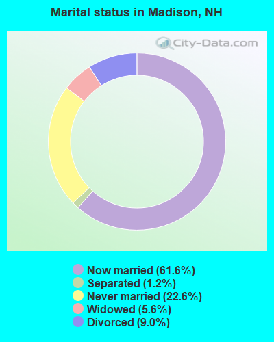
- Never married: 22.6%
- Now married: 61.6%
- Separated: 1.2%
- Widowed: 5.6%
- Divorced: 9.0%
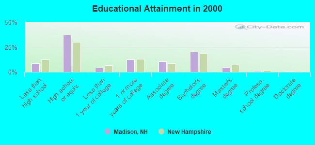
For population 25 years and over in Madison:
- High school or higher: 91.5%
- Bachelor's degree or higher: 26.4%
- Graduate or professional degree: 6.0%
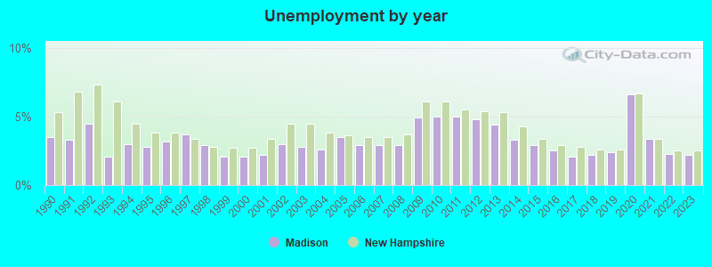
- Unemployed: 2.4%
- Mean travel time to work (commute): 25.3 minutes
| Here: | 9.0 |
| New Hampshire average: | 10.9 |
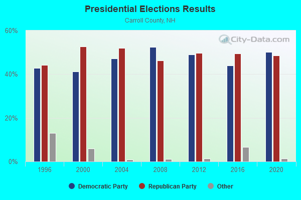
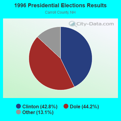
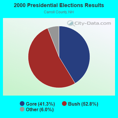

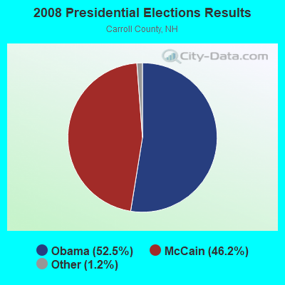
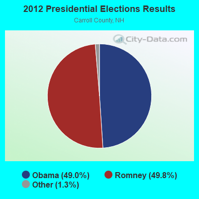
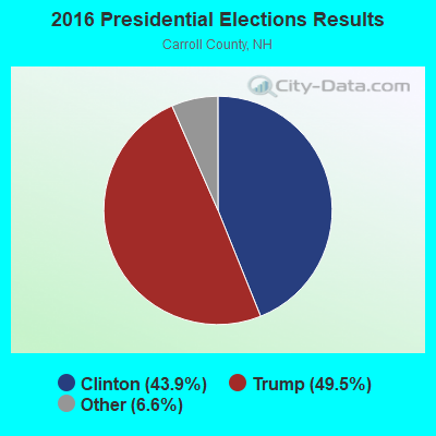
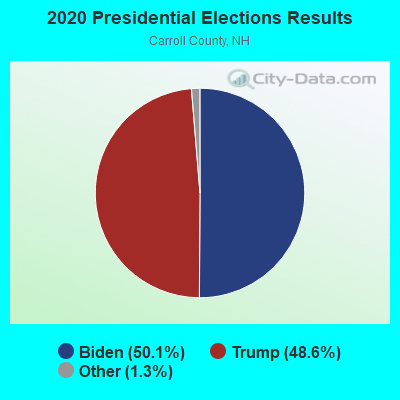
Graphs represent county-level data. Detailed 2008 Election Results
Religion statistics for Madison, NH (based on Carroll County data)
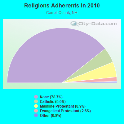
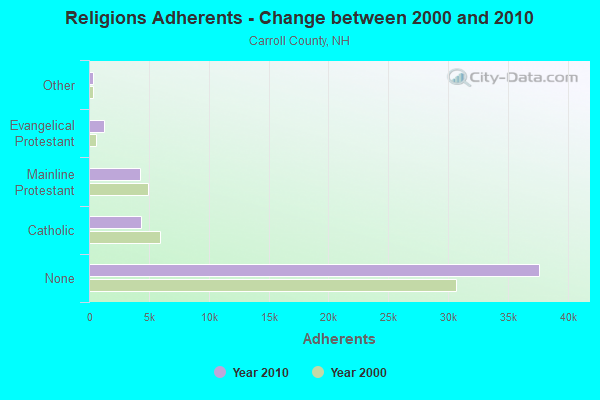
| Religion | Adherents | Congregations |
|---|---|---|
| Catholic | 4,304 | 2 |
| Mainline Protestant | 4,266 | 30 |
| Evangelical Protestant | 1,241 | 14 |
| Other | 366 | 5 |
| None | 37,641 | - |
Food Environment Statistics:
| Here: | 4.23 / 10,000 pop. |
| New Hampshire: | 2.14 / 10,000 pop. |
| Carroll County: | 2.54 / 10,000 pop. |
| New Hampshire: | 1.78 / 10,000 pop. |
| Carroll County: | 8.47 / 10,000 pop. |
| New Hampshire: | 4.02 / 10,000 pop. |
| Carroll County: | 24.13 / 10,000 pop. |
| New Hampshire: | 9.70 / 10,000 pop. |
| Here: | 8.8% |
| New Hampshire: | 7.6% |
| Carroll County: | 21.2% |
| State: | 24.4% |
| Carroll County: | 16.9% |
| State: | 15.9% |
Businesses in Madison, NH
- MasterBrand Cabinets: 2
Strongest AM radio stations in Madison:
- WBNC (1050 AM; 1 kW; CONWAY, NH; Owner: MT. WASHINGTON RADIO & GRAMOPHONE, L.L.C.)
- WMTW (870 AM; 10 kW; GORHAM, ME; Owner: RADIO PARTNERS OF MAINE, L.P.)
- WASR (1420 AM; 5 kW; WOLFEBORO, NH; Owner: RADIO WOLFEBORO, INC.)
- WRKO (680 AM; 50 kW; BOSTON, MA; Owner: ENTERCOM BOSTON LICENSE, LLC)
- WGIN (930 AM; 10 kW; ROCHESTER, NH; Owner: CAPSTAR TX LIMITED PARTNERSHIP)
- WPNH (1300 AM; 5 kW; PLYMOUTH, NH; Owner: NORTHEAST COMMUNICATIONS CORPORATION)
- WEEI (850 AM; 50 kW; BOSTON, MA; Owner: ENTERCOM BOSTON LICENSE, LLC)
- WTME (780 AM; 10 kW; RUMFORD, ME; Owner: MOUNTAIN VALLEY BROADCASTING, INC.)
- WGAN (560 AM; 5 kW; PORTLAND, ME; Owner: SAGA COMMUNICATIONS OF NEW ENGLAND, LLC)
- WCRN (830 AM; 50 kW; WORCESTER, MA; Owner: CARTER BROADCASTING CORPORATION)
- WBZ (1030 AM; 50 kW; BOSTON, MA; Owner: INFINITY BROADCASTING OPERATIONS, INC.)
- WNNZ (640 AM; 50 kW; WESTFIELD, MA; Owner: CLEAR CHANNEL BROADCASTING LICENSES, INC.)
- WEZS (1350 AM; 5 kW; LACONIA, NH; Owner: GARY W. HAMMOND)
Strongest FM radio stations in Madison:
- WMWV (93.5 FM; CONWAY, NH; Owner: MT. WASHINGTON RADIO & GRAMOPHONE, L.L.C.)
- WVMJ (104.5 FM; CONWAY, NH; Owner: MT. WASHINGTON RADIO & GRAMOPHONE, L.L.C.)
- WSCY (106.9 FM; MOULTONBOROUGH, NH; Owner: NORTHEAST COMMUNICATIONS CORPORATION)
- WPKQ (103.7 FM; NORTH CONWAY, NH; Owner: CITADEL BROADCASTING COMPANY)
- WHOM (94.9 FM; MT. WASHINGTON, NH; Owner: CITADEL BROADCASTING COMPANY)
- WVFM (105.7 FM; CAMPTON, NH; Owner: DEVON BROADCASTING COMPANY, INC.)
- WMEA (90.1 FM; PORTLAND, ME; Owner: MAINE PUBLIC BROADCASTING CORPORATION)
- WBLM (102.9 FM; PORTLAND, ME; Owner: CITADEL BROADCASTING COMPANY)
- WLKZ (104.9 FM; WOLFEBORO, NH; Owner: TELE-MEDIA COMPANY OF NEW HAMPSHIRE, L.L.C.)
- WPNH-FM (100.1 FM; PLYMOUTH, NH; Owner: NORTHEAST COMMUNICATIONS CORPORATION)
- WGMT (97.7 FM; LYNDON, VT; Owner: VERMONT BROADCAST ASSOCIATES, INC.)
- WMTK (106.3 FM; LITTLETON, NH; Owner: VERMONT BROADCAST ASSOCIATES, INC.)
- WNHI (93.3 FM; BELMONT, NH; Owner: CONCORD BROADCASTING, L.L.C.)
- WLOB-FM (96.3 FM; RUMFORD, ME; Owner: ATLANTIC COAST RADIO, LLC)
- WMEX (106.5 FM; FARMINGTON, NH; Owner: WIMMEX, LLC)
- WXXS (102.3 FM; LANCASTER, NH; Owner: BARRY P. LUNDERVILLE)
- WJBQ (97.9 FM; PORTLAND, ME; Owner: CITADEL BROADCASTING COMPANY)
- WTHT (107.5 FM; LEWISTON, ME; Owner: RADIO PARTNERS OF MAINE, L.P.)
- WLNH-FM (98.3 FM; LACONIA, NH; Owner: WLNH RADIO, INC)
TV broadcast stations around Madison:
- WMTW-TV (Channel 8; POLAND SPRING, ME; Owner: WMTW BROADCAST GROUP, LLC)
- WCSH (Channel 6; PORTLAND, ME; Owner: PACIFIC AND SOUTHERN COMPANY, INC.)
- WGME-TV (Channel 13; PORTLAND, ME; Owner: WGME LICENSEE, LLC)
- WMEA-TV (Channel 26; BIDDEFORD, ME; Owner: MAINE PUBLIC BROADCASTING CORP.)
- Madison, New Hampshire
- Fatal accident count8
- Vehicles involved in fatal accidents10
- Fatal accidents involving drunk persons:2
- Fatalities8
- Persons involved in fatal accidents19
- Pedestrians involved in fatal accidents0
- New Hampshire average
- Fatal accident count1044
- Vehicles involved in fatal accidents1503
- Fatal accidents involving drunk persons470
- Fatalities1139
- Persons involved in fatal accidents2503
- Pedestrians involved in fatal accidents59
- National Bridge Inventory (NBI) Statistics
- 3Number of bridges
- 10ft / 2.6mTotal length
- $9,426,000Total costs
- 5,264Total average daily traffic
- 209Total average daily truck traffic
- 7,789Total future (year 2042) average daily traffic
FCC Registered Commercial Land Mobile Towers:
1- Atop Oak Hill, 2.1 Km South Of The Intersection Of St Route 113 And St Route 16 (Lat: 43.946667 Lon: -71.139444), Type: Pole, Structure height: 23 m, Call Sign: WPZA308, Licensee ID: L00526032,
Assigned Frequencies: 450.050 MHz, Grant Date: 12/11/2003, Expiration Date: 04/01/2030, Certifier: Ronald R Frizzell, Registrant: Mt. Washington Radio & Gramophone, L.L.C.
FCC Registered Private Land Mobile Towers:
1- Oak Hill (Lat: 43.945639 Lon: -71.138139), Call Sign: WNPU432,
Assigned Frequencies: 462.875 MHz, Grant Date: 11/03/2020, Expiration Date: 11/01/2030, Certifier: Kathy M Paskevich, Registrant: Jkl Communications LLC, 142 Avenue C, Williston, VT 05495, Phone: (802) 860-0000, Fax: (802) 860-5037, Email:
FCC Registered Broadcast Land Mobile Towers:
5- Madison Rd Rt 113 (Lat: 43.944528 Lon: -71.148972), Call Sign: KTF698, Licensee ID: L00110386,
Assigned Frequencies: 43.1800 MHz, Grant Date: 04/29/1997, Expiration Date: 04/21/2002, Cancellation Date: 08/25/2002, Certifier: Shaun Carroll, Sr., Registrant: Carroll Concrete Co. Inc.
- Oak Hill (Lat: 43.947028 Lon: -71.139806), Call Sign: WNFH318, Licensee ID: L00045545,
Assigned Frequencies: 43.0600 MHz, Grant Date: 11/08/1995, Expiration Date: 01/02/2001, Cancellation Date: 03/04/2001, Registrant: Pike Industries Inc, Tilton, NH 03276-2000, Phone: (603) 367-8000
- Oak Hill (Lat: 43.947028 Lon: -71.139806), Type: Tower, Structure height: 34 m, Call Sign: WPTB412,
Assigned Frequencies: 43.0600 MHz, Grant Date: 08/22/2001, Expiration Date: 08/22/2011, Cancellation Date: 10/22/2011, Certifier: Nancy M Barker, Registrant: Keller And Heckman LLP, 1001 G Street, Nw, Suite 500 West, Washington, DC 20001, Phone: (202) 434-4282, Fax: (202) 434-4646, Email:
- Oak Hill, Oak Hill (Lat: 43.946639 Lon: -71.140111), Type: Ltower, Structure height: 36.6 m, Overall height: 42.7 m, Call Sign: WQAN586,
Assigned Frequencies: 159.412 MHz, Grant Date: 05/02/2014, Expiration Date: 07/08/2024, Certifier: John Arruda, Registrant: Ossipee Mountain Electronics, Moultonboro, NH 03254-0950, Phone: (603) 476-5581, Fax: (603) 476-5587, Email:
- Oak Hill, Summit Of Oak Hill (Lat: 43.947306 Lon: -71.139806), Type: Ltower, Structure height: 33.6 m, Overall height: 40 m, Call Sign: WQHA911,
Assigned Frequencies: 155.760 MHz, Grant Date: 03/20/2017, Expiration Date: 06/14/2027, Certifier: Patrick L Preece, Registrant: Ossipee Mountain Electronics, Moultonboro, NH 03254-0950, Phone: (603) 476-5581, Fax: (603) 476-5587, Email:
FCC Registered Microwave Towers:
1- OAK HILL, 98 Oak Ridge Rd (Lat: 43.947306 Lon: -71.139806), Type: Ltower, Structure height: 33.5 m, Call Sign: WRWR220, Licensee ID: L00042682,
Assigned Frequencies: 11565.0 MHz, 11565.0 MHz, 11565.0 MHz, 11565.0 MHz, 11565.0 MHz, 11565.0 MHz, 11565.0 MHz, 11565.0 MHz, Grant Date: 03/20/2023, Expiration Date: 03/20/2033, Certifier: Christopher Mattei, Registrant: Conway, Town Of, Po Box 538 35 East Conway Road, Center Conway, NH 03813, Phone: (603) 356-5715, Fax: (603) 356-8837, Email:
FCC Registered Amateur Radio Licenses:
16 (See the full list of FCC Registered Amateur Radio Licenses in Madison)FAA Registered Aircraft:
1- Aircraft: FAIRCHILD SA227BC (Category: Land, Engines: 2, Seats: 12, Weight: Up to 12,499 Pounds), Engine: Turbo-prop
N-Number: 781ML, N781ML, N-781ML, Serial Number: BC-781B, Certificate Issue Date: 12/27/2011
Registrant (LLC): Northern Wings Leasing LLC, 14 Forclaz Rd, Madison, NH 03849
2003 - 2018 National Fire Incident Reporting System (NFIRS) incidents
- Fire incident types reported to NFIRS in Madison, NH
- 16770.5%Structure Fires
- 4318.1%Outside Fires
- 156.3%Other
- 125.1%Mobile Property/Vehicle Fires
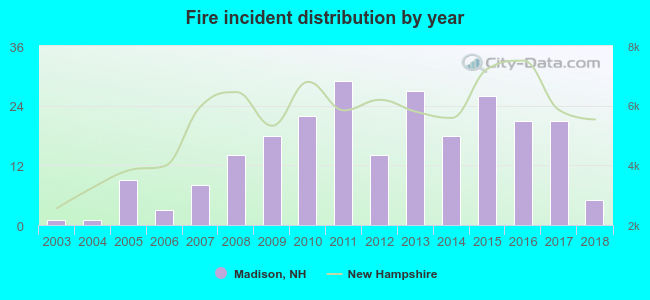 According to the data from the years 2003 - 2018 the average number of fires per year is 15. The highest number of fire incidents - 29 took place in 2011, and the least - 1 in 2003. The data has a growing trend.
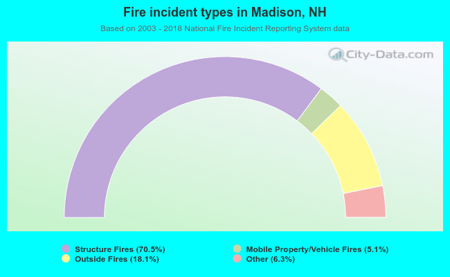 When looking into fire subcategories, the most incidents belonged to: Structure Fires (70.5%), and Outside Fires (18.1%).
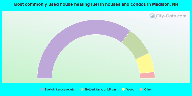
- 69.8%Fuel oil, kerosene, etc.
- 16.0%Bottled, tank, or LP gas
- 10.6%Wood
- 2.8%Electricity
- 0.5%Coal or coke
- 0.3%Utility gas
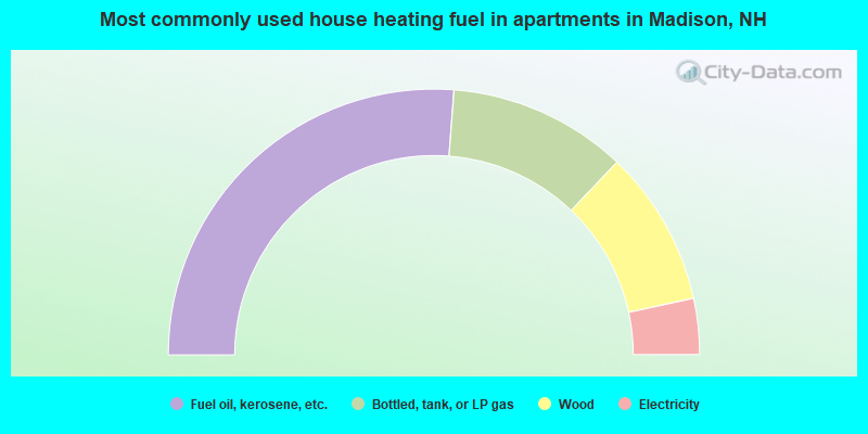
- 52.4%Fuel oil, kerosene, etc.
- 21.8%Bottled, tank, or LP gas
- 19.0%Wood
- 6.8%Electricity
Madison compared to New Hampshire state average:
- Unemployed percentage significantly below state average.
- Hispanic race population percentage below state average.
- Foreign-born population percentage significantly below state average.
- Renting percentage below state average.
- Length of stay since moving in significantly above state average.
- Number of rooms per house significantly below state average.
- House age significantly below state average.

|
Total of 3 patent applications in 2008-2024.