Albany, New Hampshire
Submit your own pictures of this town and show them to the world
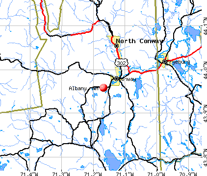
- OSM Map
- General Map
- Google Map
- MSN Map
Population change since 2000: +12.4%
 |
| Males: 369 | |
| Females: 366 |
| Median resident age: | 45.6 years |
| New Hampshire median age: | 43.9 years |
Zip codes: 03818.
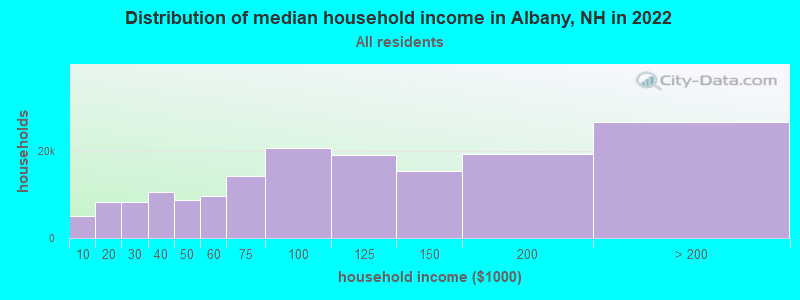
| Albany: | $69,922 |
| NH: | $89,992 |
Estimated per capita income in 2022: $46,443 (it was $20,690 in 2000)
Albany town income, earnings, and wages data
Estimated median house or condo value in 2022: $233,123 (it was $76,200 in 2000)
| Albany: | $233,123 |
| NH: | $384,700 |
Mean prices in 2022: all housing units: $505,201; detached houses: $542,950; townhouses or other attached units: $363,532; in 2-unit structures: $373,773; in 3-to-4-unit structures: $587,160; in 5-or-more-unit structures: $313,992; mobile homes: $113,714; occupied boats, rvs, vans, etc.: $118,400
Detailed information about poverty and poor residents in Albany, NH
Compare current foreclosures near Albany, NH:
| Photo | Address | Area | Beds / Baths | Price | Details |
|---|---|---|---|---|---|

|
#1
Nh Route 16
Conway, NH 03818
|
2,695 sq. feet
|
2 baths 3 beds |
show details | |

|
#2
Pequawket Dr
Conway, NH 03818
|
1,008 sq. feet
|
1 baths 2 beds |
show details | |

|
#3
Fein Ln
Center Conway, NH 03813
|
1,040 sq. feet
|
1 baths 3 beds |
show details | |

|
#4
Henry Cotton Rd
Center Conway, NH 03813
|
1,792 sq. feet
|
2 baths 3 beds |
show details | |

|
#5
Summit View Dr
Moultonborough, NH 03254
|
840 sq. feet
|
2 baths 3 beds |
show details | |

|
#6
Old Colony Rd
Conway, NH 03818
|
- sq. feet
|
- baths - beds |
show details | |

|
#7
Pleasant St
Conway, NH 03818
|
- sq. feet
|
- baths - beds |
show details | |

|
#8
Fein Ln
Conway, NH 03818
|
- sq. feet
|
- baths - beds |
show details | |

|
#9
Black Bear Rd
Fryeburg, ME 04037
|
1,296 sq. feet
|
- baths - beds |
show details | |

|
#10
Blake Hill Rd
Center Conway, NH 03813
|
- sq. feet
|
- baths - beds |
show details |
| Photo | Address | Area | Beds / Baths | Price | Details |
|---|---|---|---|---|---|

|
Check over 1 million property listings on Foreclosure.com!
|
browse all offers | |||
| Photo | Address | Area | Beds / Baths | Price | Details |
|---|

- 70796.2%White alone
- 101.4%Hispanic
- 81.1%Two or more races
- 40.5%American Indian alone
- 30.4%Black alone
- 30.4%Asian alone
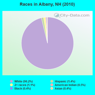
Races in Albany detailed stats: ancestries, foreign born residents, place of birth
According to our research of New Hampshire and other state lists, there was 1 registered sex offender living in Albany, New Hampshire as of April 27, 2024.
The ratio of all residents to sex offenders in Albany is 735 to 1.
The ratio of registered sex offenders to all residents in this city is lower than the state average.
 Recent articles from our blog. Our writers, many of them Ph.D. graduates or candidates, create easy-to-read articles on a wide variety of topics.

 | Your Advice on moving to the Conway Area (18 replies) |
| Low density housing is killing nh! (67 replies) |
| Escape from MA (5 replies) |
| Move to NH from FL, advice/opinions/suggestions wanted! (75 replies) |
| Retirement/Relocation (38 replies) |
| We need rain (110 replies) |
Latest news from Albany, NH collected exclusively by city-data.com from local newspapers, TV, and radio stations
Ancestries: United States (20.3%), Irish (19.3%), French (18.3%), English (17.0%), Italian (5.7%), German (5.4%).
Current Local Time: EST time zone
Incorporated in 1766
Elevation: 641 feet
Land area: 74.7 square miles.
Population density: 9.8 people per square mile (very low).
4 residents are foreign born
| This town: | 0.6% |
| New Hampshire: | 4.4% |
| Albany town: | 2.1% ($1,569) |
| New Hampshire: | 2.3% ($2,946) |
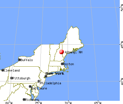
Nearest city with pop. 50,000+: Portland, ME  (54.2 miles , pop. 64,249).
Nearest city with pop. 200,000+: Boston, MA (113.8 miles , pop. 589,141).
Nearest city with pop. 1,000,000+: Bronx, NY (253.0 miles , pop. 1,332,650).
Nearest cities:
), )Latitude: 43.96 N, Longitude: 71.27 W
Area code commonly used in this area: 603

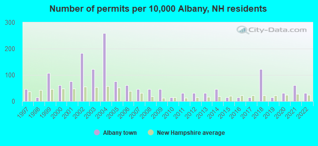
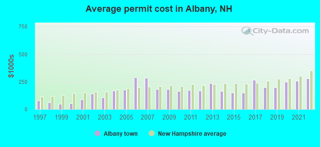
Single-family new house construction building permits:
- 2022: 2 buildings, average cost: $279,200
- 2021: 4 buildings, average cost: $259,200
- 2020: 2 buildings, average cost: $248,200
- 2019: 1 building, cost: $200,000
- 2018: 8 buildings, average cost: $200,000
- 2017: 1 building, cost: $267,800
- 2016: 1 building, cost: $150,000
- 2015: 1 building, cost: $150,000
- 2014: 3 buildings, average cost: $164,300
- 2013: 2 buildings, average cost: $235,300
- 2012: 2 buildings, average cost: $168,300
- 2011: 2 buildings, average cost: $172,800
- 2010: 1 building, cost: $165,900
- 2009: 3 buildings, average cost: $182,400
- 2008: 3 buildings, average cost: $182,400
- 2007: 3 buildings, average cost: $283,300
- 2006: 4 buildings, average cost: $287,500
- 2005: 5 buildings, average cost: $178,600
- 2004: 17 buildings, average cost: $166,500
- 2003: 8 buildings, average cost: $109,100
- 2002: 12 buildings, average cost: $141,100
- 2001: 5 buildings, average cost: $91,000
- 2000: 4 buildings, average cost: $55,000
- 1999: 7 buildings, average cost: $50,000
- 1998: 1 building, cost: $62,000
- 1997: 3 buildings, average cost: $80,000
| Here: | 2.7% |
| New Hampshire: | 2.5% |
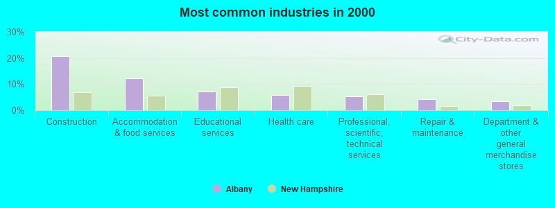
- Construction (20.7%)
- Accommodation & food services (12.3%)
- Educational services (7.1%)
- Health care (5.8%)
- Professional, scientific, technical services (5.2%)
- Repair & maintenance (4.2%)
- Department & other general merchandise stores (3.6%)
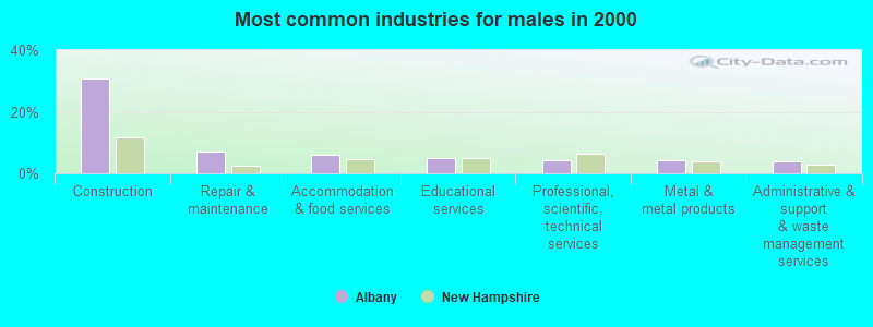
- Construction (30.8%)
- Repair & maintenance (7.1%)
- Accommodation & food services (6.0%)
- Educational services (4.9%)
- Professional, scientific, technical services (4.4%)
- Metal & metal products (4.4%)
- Administrative & support & waste management services (3.8%)
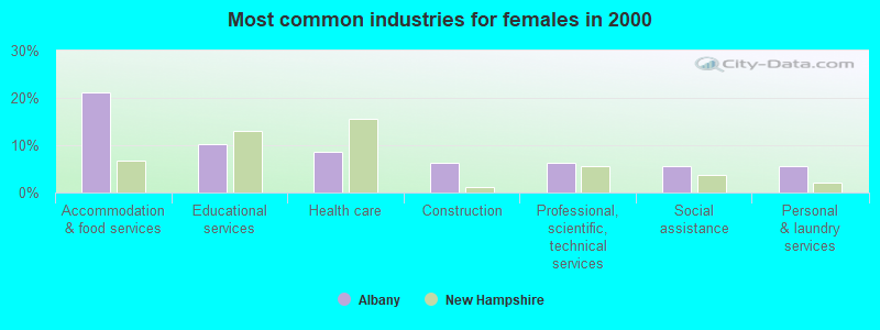
- Accommodation & food services (21.3%)
- Educational services (10.2%)
- Health care (8.7%)
- Construction (6.3%)
- Professional, scientific, technical services (6.3%)
- Social assistance (5.5%)
- Personal & laundry services (5.5%)
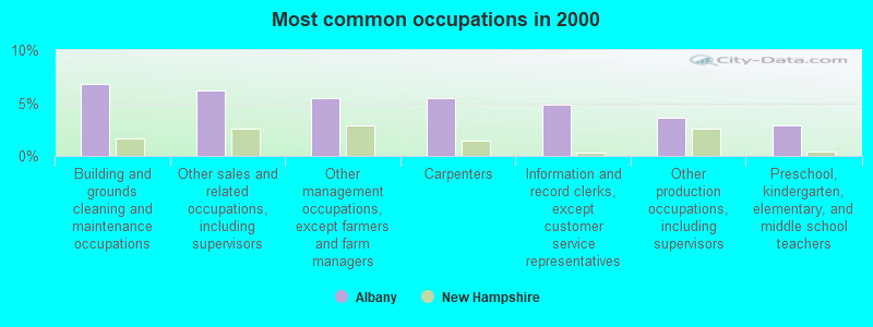
- Building and grounds cleaning and maintenance occupations (6.8%)
- Other sales and related occupations, including supervisors (6.1%)
- Other management occupations, except farmers and farm managers (5.5%)
- Carpenters (5.5%)
- Information and record clerks, except customer service representatives (4.9%)
- Other production occupations, including supervisors (3.6%)
- Preschool, kindergarten, elementary, and middle school teachers (2.9%)
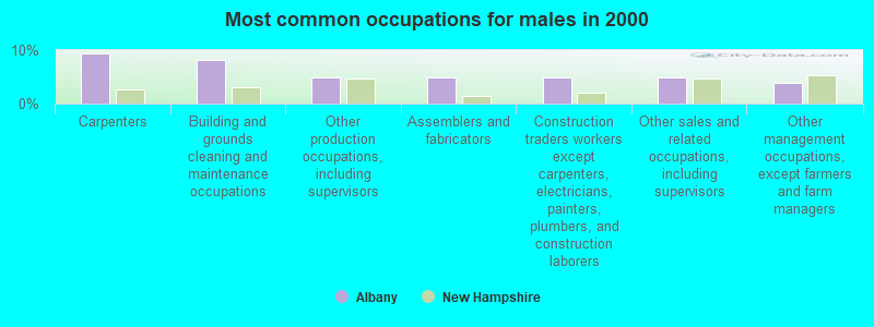
- Carpenters (9.3%)
- Building and grounds cleaning and maintenance occupations (8.2%)
- Other production occupations, including supervisors (4.9%)
- Assemblers and fabricators (4.9%)
- Construction traders workers except carpenters, electricians, painters, plumbers, and construction laborers (4.9%)
- Other sales and related occupations, including supervisors (4.9%)
- Other management occupations, except farmers and farm managers (3.8%)
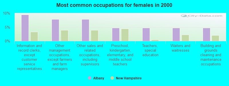
- Information and record clerks, except customer service representatives (9.4%)
- Other management occupations, except farmers and farm managers (7.9%)
- Other sales and related occupations, including supervisors (7.9%)
- Preschool, kindergarten, elementary, and middle school teachers (4.7%)
- Teachers, special education (4.7%)
- Waiters and waitresses (4.7%)
- Building and grounds cleaning and maintenance occupations (4.7%)
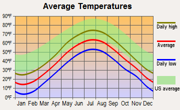
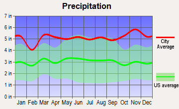
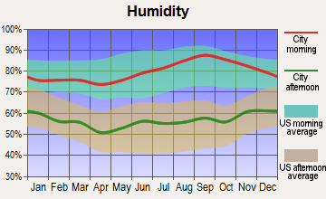
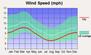
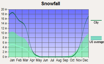
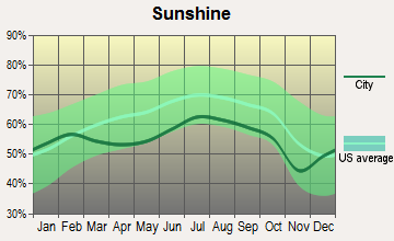
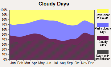
Average climate in Albany, New Hampshire
Based on data reported by over 4,000 weather stations
(lower is better)
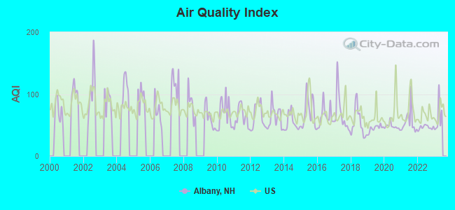
Air Quality Index (AQI) level in 2022 was 46.4. This is significantly better than average.
| City: | 46.4 |
| U.S.: | 72.6 |
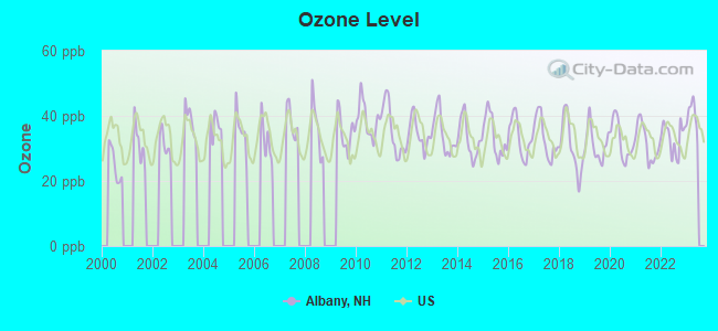
Ozone [ppb] level in 2022 was 33.3. This is about average. Closest monitor was 7.1 miles away from the city center.
| City: | 33.3 |
| U.S.: | 33.3 |
Tornado activity:
Albany-area historical tornado activity is below New Hampshire state average. It is 75% smaller than the overall U.S. average.
On 7/18/1963, a category F2 (max. wind speeds 113-157 mph) tornado 25.3 miles away from the Albany town center caused between $5000 and $50,000 in damages.
On 8/11/1966, a category F2 tornado 33.4 miles away from the town center caused between $50,000 and $500,000 in damages.
Earthquake activity:
Albany-area historical earthquake activity is significantly above New Hampshire state average. It is 72% smaller than the overall U.S. average.On 4/20/2002 at 10:50:47, a magnitude 5.3 (5.3 ML, Depth: 3.0 mi, Class: Moderate, Intensity: VI - VII) earthquake occurred 125.9 miles away from the city center
On 4/20/2002 at 10:50:47, a magnitude 5.2 (5.2 MB, 4.2 MS, 5.2 MW, 5.0 MW) earthquake occurred 126.4 miles away from Albany center
On 10/7/1983 at 10:18:46, a magnitude 5.3 (5.1 MB, 5.3 LG, 5.1 ML) earthquake occurred 152.7 miles away from the city center
On 1/19/1982 at 00:14:42, a magnitude 4.7 (4.5 MB, 4.7 MD, 4.5 LG, Class: Light, Intensity: IV - V) earthquake occurred 35.8 miles away from the city center
On 10/16/2012 at 23:12:25, a magnitude 4.7 (4.7 ML, Depth: 10.0 mi) earthquake occurred 39.9 miles away from Albany center
On 8/21/1996 at 07:54:14, a magnitude 3.8 (3.8 LG, 3.6 LG, Depth: 6.2 mi, Class: Light, Intensity: II - III) earthquake occurred 15.8 miles away from the city center
Magnitude types: regional Lg-wave magnitude (LG), body-wave magnitude (MB), duration magnitude (MD), local magnitude (ML), surface-wave magnitude (MS), moment magnitude (MW)
Natural disasters:
The number of natural disasters in Carroll County (29) is a lot greater than the US average (15).Major Disasters (Presidential) Declared: 17
Emergencies Declared: 9
Causes of natural disasters: Storms: 12, Floods: 11, Winter Storms: 5, Hurricanes: 4, Snows: 4, Snowstorms: 2, Blizzard: 1, Heavy Rain: 1, Ice Storm: 1, Snowfall: 1, Tornado: 1, Tropical Storm: 1, Wind: 1, Other: 1 (Note: some incidents may be assigned to more than one category).
Hospitals and medical centers near Albany:
- MERRIMAN HOUSE (Nursing Home, about 9 miles away; NORTH CONWAY, NH)
- MINERAL SPRINGS OF NORTH CONWAY CARE AND REHABILIT (Nursing Home, about 9 miles away; NORTH CONWAY, NH)
- VN AND HSP CARE SVC OF N CAR CTY (Home Health Center, about 10 miles away; NORTH CONWAY, NH)
- HICKS NURSING HOME (Nursing Home, about 16 miles away; FRYEBURG, ME)
- MOULTONBORO VNS (Home Health Center, about 16 miles away; MOULTONBOROUGH, NH)
- FRYEBURG HEALTH CARE CENTER (Nursing Home, about 16 miles away; FRYEBURG, ME)
Airports located in Albany:
- Leavitt Airport (NH38) (Runways: 1)
Colleges/universities with over 2000 students nearest to Albany:
- Plymouth State University (about 26 miles; Plymouth, NH; Full-time enrollment: 4,838)
- Saint Joseph's College of Maine (about 41 miles; Standish, ME; FT enrollment: 2,010)
- NHTI-Concord's Community College (about 53 miles; Concord, NH; FT enrollment: 2,865)
- Dartmouth College (about 54 miles; Hanover, NH; FT enrollment: 6,030)
- University of Southern Maine (about 54 miles; Portland, ME; FT enrollment: 6,647)
- University of New England (about 57 miles; Biddeford, ME; FT enrollment: 4,539)
- Southern Maine Community College (about 57 miles; South Portland, ME; FT enrollment: 4,666)
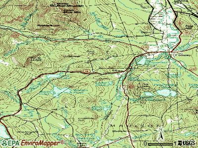
Points of interest:
Notable locations in Albany: White Ledge Campground (A), Liberty Shelter (B), Old Slag Camp (C), Camp Penacook (D), Blackberry Crossing Campground (E), Carrigain Outlook (F), Covered Bridge Campground (G), Ellen Falls (H), Dugway Forest Camp (I), Dugway Picnic Area (J), Blackberry Crossing Campground (K), Jigger Jonnson Campground (L), Clement Inn (M), Pass Campground (N), Jigger Johnson Campground (O), Passaconaway Campground (P), Dugway Picnic Area (Q), Covered Bridge Campground (R), University of New Hampshire Forest Camp (S). Display/hide their locations on the map
Church in Albany: Albany Chapel (A). Display/hide its location on the map
Cemetery: Albany Cemetery (1). Display/hide its location on the map
Lakes, reservoirs, and swamps: Haunted Pond (A), Whitton Pond (B), Iona Lake (C), Red Eagle Pond (D), Moose Pond (E), Back Pond (F), Falls Pond (G), Mirror Lake (H). Display/hide their locations on the map
Streams, rivers, and creeks: White Brook (A), Hobbs Brook (B), Haskell Brook (C), Pond Brook (D), Kelly Brook (E), Meadow Brook (F), Whitin Brook (G), Dry Brook (H), Downes Brook (I). Display/hide their locations on the map
Parks in Albany include: Mount Chocorua Scenic Area (1), Rocky Gorge Scenic Area (2). Display/hide their locations on the map
Drinking water stations with addresses in Albany and their reported violations in the past:
PIPER MEADOWS PRIVATE COMMUNTY (Population served: 125, Groundwater):Past monitoring violations:
- Failure To Address Deficiency - In JUN-30-2013, Contaminant: GROUNDWATER RULE. Follow-up actions: St Public Notif requested (JUL-02-2013), St Violation/Reminder Notice (JUL-02-2013), St Compliance achieved (JUL-31-2013), St Public Notif received (AUG-06-2013)
- 5 routine major monitoring violations
- One regular monitoring violation
| This town: | 2.3 people |
| New Hampshire: | 2.5 people |
| This town: | 64.5% |
| Whole state: | 66.3% |
| This town: | 11.3% |
| Whole state: | 8.3% |
Likely homosexual households (counted as self-reported same-sex unmarried-partner households)
- Lesbian couples: 0.3% of all households
- Gay men: 0.6% of all households
| This town: | 15.7% |
| Whole state: | 6.5% |
| This town: | 7.3% |
| Whole state: | 2.8% |
For population 15 years and over in Albany:
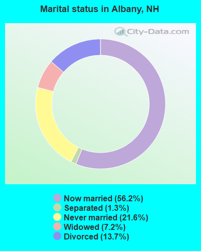
- Never married: 21.6%
- Now married: 56.2%
- Separated: 1.3%
- Widowed: 7.2%
- Divorced: 13.7%
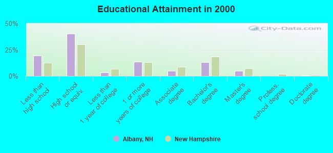
For population 25 years and over in Albany:
- High school or higher: 80.4%
- Bachelor's degree or higher: 18.3%
- Graduate or professional degree: 5.1%
- Unemployed: 4.9%
- Mean travel time to work (commute): 19.9 minutes
| Here: | 9.9 |
| New Hampshire average: | 10.9 |
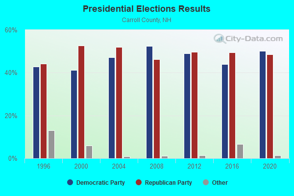
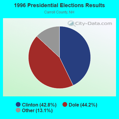
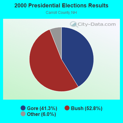

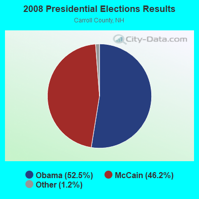
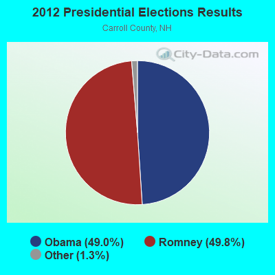
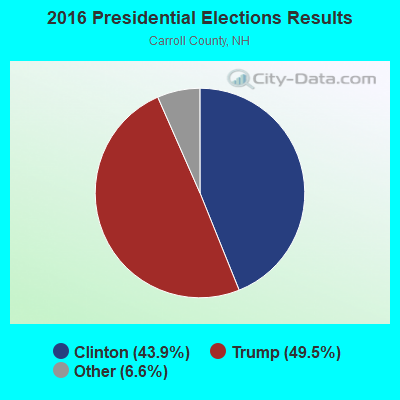
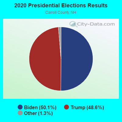
Graphs represent county-level data. Detailed 2008 Election Results
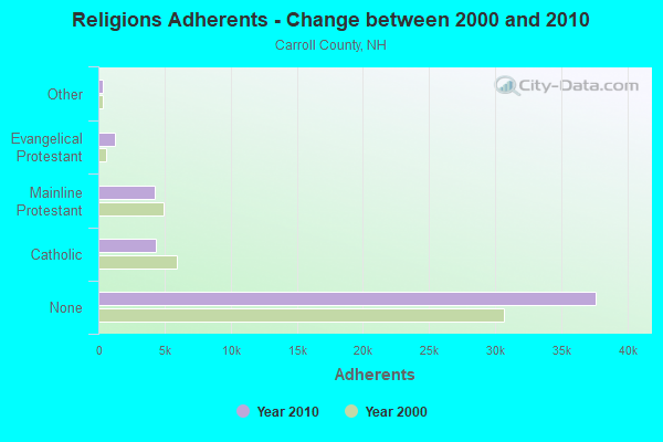
Religion statistics for Albany, NH (based on Carroll County data)
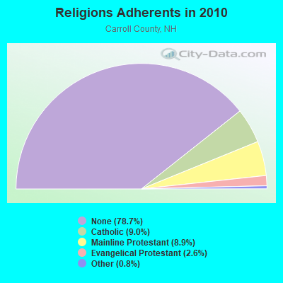
| Religion | Adherents | Congregations |
|---|---|---|
| Catholic | 4,304 | 2 |
| Mainline Protestant | 4,266 | 30 |
| Evangelical Protestant | 1,241 | 14 |
| Other | 366 | 5 |
| None | 37,641 | - |
Food Environment Statistics:
| Carroll County: | 4.23 / 10,000 pop. |
| New Hampshire: | 2.14 / 10,000 pop. |
| Carroll County: | 2.54 / 10,000 pop. |
| New Hampshire: | 1.78 / 10,000 pop. |
| Carroll County: | 8.47 / 10,000 pop. |
| State: | 4.02 / 10,000 pop. |
| Here: | 24.13 / 10,000 pop. |
| State: | 9.70 / 10,000 pop. |
| This county: | 8.8% |
| New Hampshire: | 7.6% |
| Carroll County: | 21.2% |
| New Hampshire: | 24.4% |
| This county: | 16.9% |
| State: | 15.9% |
Strongest AM radio stations in Albany:
- WBNC (1050 AM; 1 kW; CONWAY, NH; Owner: MT. WASHINGTON RADIO & GRAMOPHONE, L.L.C.)
- WRKO (680 AM; 50 kW; BOSTON, MA; Owner: ENTERCOM BOSTON LICENSE, LLC)
- WPNH (1300 AM; 5 kW; PLYMOUTH, NH; Owner: NORTHEAST COMMUNICATIONS CORPORATION)
- WMTW (870 AM; 10 kW; GORHAM, ME; Owner: RADIO PARTNERS OF MAINE, L.P.)
- WASR (1420 AM; 5 kW; WOLFEBORO, NH; Owner: RADIO WOLFEBORO, INC.)
- WGIN (930 AM; 10 kW; ROCHESTER, NH; Owner: CAPSTAR TX LIMITED PARTNERSHIP)
- WTME (780 AM; 10 kW; RUMFORD, ME; Owner: MOUNTAIN VALLEY BROADCASTING, INC.)
- WEEI (850 AM; 50 kW; BOSTON, MA; Owner: ENTERCOM BOSTON LICENSE, LLC)
- WCRN (830 AM; 50 kW; WORCESTER, MA; Owner: CARTER BROADCASTING CORPORATION)
- WNNZ (640 AM; 50 kW; WESTFIELD, MA; Owner: CLEAR CHANNEL BROADCASTING LICENSES, INC.)
- WBZ (1030 AM; 50 kW; BOSTON, MA; Owner: INFINITY BROADCASTING OPERATIONS, INC.)
- WEZS (1350 AM; 5 kW; LACONIA, NH; Owner: GARY W. HAMMOND)
- WGAN (560 AM; 5 kW; PORTLAND, ME; Owner: SAGA COMMUNICATIONS OF NEW ENGLAND, LLC)
Strongest FM radio stations in Albany:
- WSCY (106.9 FM; MOULTONBOROUGH, NH; Owner: NORTHEAST COMMUNICATIONS CORPORATION)
- WPKQ (103.7 FM; NORTH CONWAY, NH; Owner: CITADEL BROADCASTING COMPANY)
- WHOM (94.9 FM; MT. WASHINGTON, NH; Owner: CITADEL BROADCASTING COMPANY)
- WVFM (105.7 FM; CAMPTON, NH; Owner: DEVON BROADCASTING COMPANY, INC.)
- WMWV (93.5 FM; CONWAY, NH; Owner: MT. WASHINGTON RADIO & GRAMOPHONE, L.L.C.)
- WVMJ (104.5 FM; CONWAY, NH; Owner: MT. WASHINGTON RADIO & GRAMOPHONE, L.L.C.)
- WMEA (90.1 FM; PORTLAND, ME; Owner: MAINE PUBLIC BROADCASTING CORPORATION)
- WPNH-FM (100.1 FM; PLYMOUTH, NH; Owner: NORTHEAST COMMUNICATIONS CORPORATION)
- WLKZ (104.9 FM; WOLFEBORO, NH; Owner: TELE-MEDIA COMPANY OF NEW HAMPSHIRE, L.L.C.)
- WBLM (102.9 FM; PORTLAND, ME; Owner: CITADEL BROADCASTING COMPANY)
- WMTK (106.3 FM; LITTLETON, NH; Owner: VERMONT BROADCAST ASSOCIATES, INC.)
- WGMT (97.7 FM; LYNDON, VT; Owner: VERMONT BROADCAST ASSOCIATES, INC.)
- WHDQ (106.1 FM; CLAREMONT, NH; Owner: GREAT NORTHERN RADIO, L.L.C.)
- WXXS (102.3 FM; LANCASTER, NH; Owner: BARRY P. LUNDERVILLE)
- WLOB-FM (96.3 FM; RUMFORD, ME; Owner: ATLANTIC COAST RADIO, LLC)
- WEVH (91.3 FM; HANOVER, NH; Owner: NEW HAMPSHIRE PUBLIC RADIO INC)
- WNHI (93.3 FM; BELMONT, NH; Owner: CONCORD BROADCASTING, L.L.C.)
- WMEX (106.5 FM; FARMINGTON, NH; Owner: WIMMEX, LLC)
- WLTN-FM (96.7 FM; LISBON, NH; Owner: PROFILE BROADCASTING CO., INC.)
- WLNH-FM (98.3 FM; LACONIA, NH; Owner: WLNH RADIO, INC)
TV broadcast stations around Albany:
- WMTW-TV (Channel 8; POLAND SPRING, ME; Owner: WMTW BROADCAST GROUP, LLC)
- WCSH (Channel 6; PORTLAND, ME; Owner: PACIFIC AND SOUTHERN COMPANY, INC.)
- WGME-TV (Channel 13; PORTLAND, ME; Owner: WGME LICENSEE, LLC)
- WMEA-TV (Channel 26; BIDDEFORD, ME; Owner: MAINE PUBLIC BROADCASTING CORP.)
- Albany, New Hampshire
- Fatal accident count27
- Vehicles involved in fatal accidents39
- Fatal accidents involving drunk persons:10
- Fatalities29
- Persons involved in fatal accidents67
- Pedestrians involved in fatal accidents0
- New Hampshire average
- Fatal accident count2497
- Vehicles involved in fatal accidents3680
- Fatal accidents involving drunk persons892
- Fatalities2734
- Persons involved in fatal accidents5787
- Pedestrians involved in fatal accidents229
- National Bridge Inventory (NBI) Statistics
- 10Number of bridges
- 46ft / 13.9mTotal length
- $31,420,000Total costs
- 12,357Total average daily traffic
- 428Total average daily truck traffic
- 18,283Total future (year 2042) average daily traffic
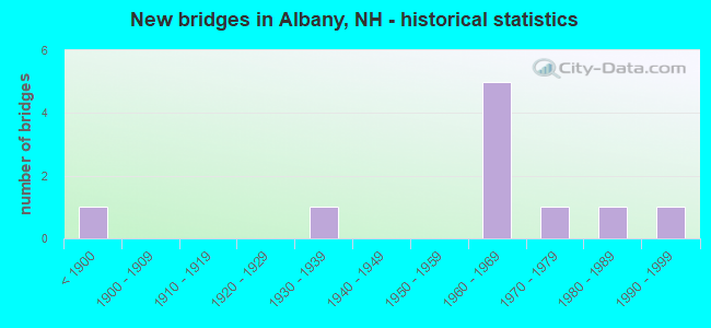
- New bridges - historical statistics
- 1Before 1900
- 11930-1939
- 51960-1969
- 11970-1979
- 11980-1989
- 11990-1999
FCC Registered Cell Phone Towers:
2 (See the full list of FCC Registered Cell Phone Towers in Albany)FCC Registered Antenna Towers:
7 (See the full list of FCC Registered Antenna Towers)FCC Registered Microwave Towers:
2- Albany, 1bald Hill Road (Lat: 43.974806 Lon: -71.151194), Type: Tower, Structure height: 43 m, Overall height: 45.8 m, Call Sign: WPRR829,
Assigned Frequencies: 6315.84 MHz, 6555.00 MHz, 6555.00 MHz, 6256.54 MHz, Grant Date: 12/21/2010, Expiration Date: 01/03/2021, Cancellation Date: 02/24/2014, Certifier: Richard A Craig, Registrant: Verizon Wireless, 1120 Sanctuary Pkwy, #150 Gasa5reg, Alpharetta, GA 30009-7630, Phone: (770) 797-1070, Fax: (770) 797-1036, Email:
- Albany NH, 2209 Route 16 (Bald Hill Rd) (Lat: 43.974694 Lon: -71.151306), Type: Ltower, Structure height: 43.3 m, Call Sign: WQSW787,
Assigned Frequencies: 11265.0 MHz, 11305.0 MHz, Grant Date: 10/24/2023, Expiration Date: 11/29/2033, Certifier: John Monday, Registrant: At&t Services, Inc., 208 S Akard St, 20f, Dallas, TX 75202, Phone: (855) 699-7073, Email:
FCC Registered Paging Towers:
1- Bear Notch Road (Lat: 44.003389 Lon: -71.319778), Call Sign: WDZ717,
Assigned Frequencies: 157.980 MHz, 157.800 MHz, Expiration Date: 11/01/1998, Cancellation Date: 10/26/1999, Registrant: T.T. Pettingell, Jr., Bear Notch Road,, Conway, NH 03818
FCC Registered Amateur Radio Licenses:
1- Call Sign: KC1API, Licensee ID: L01820401, Grant Date: 10/28/2013, Expiration Date: 10/28/2023, Certifier: Thomas E Webb, Registrant: Thomas E Webb, 72 Tabor Circle, Albany, NH 03818
FAA Registered Aircraft:
3- Aircraft: CESSNA 182P (Category: Land, Seats: 4, Weight: Up to 12,499 Pounds, Speed: 120 mph), Engine: CONT MOTOR O-470 SERIES (230 HP) (Reciprocating)
N-Number: 1592M, N1592M, N-1592M, Serial Number: 18264382, Year manufactured: 1975, Airworthiness Date: 11/25/1975, Certificate Issue Date: 03/03/2014
Registrant (Individual): Calvin Coleman, 14 Colemans Dr, Albany, NH 03818 - Aircraft: INFINITY POWER PARACHUTES LLC COMMANDER 582 (Category: Land, Seats: 2, Weight: Up to 12,499 Pounds), Engine: ROTAX 582SER (65 HP) (2 Cycle)
N-Number: 492DG, N492DG, N-492DG, Serial Number: IPP13-415, Year manufactured: 2013, Airworthiness Date: 06/04/2013, Certificate Issue Date: 08/05/2019
Registrant (Individual): Steven Carrier, 1577 Passaconaway Rd, Albany, NH 03818 - Aircraft: BUCKEYE DREAM MACHINE (Category: Land, Seats: 2, Weight: Up to 12,499 Pounds), Engine: ROTAX 582SER (65 HP) (2 Cycle)
N-Number: 90796, N90796, N-90796, Serial Number: 3488, Year manufactured: 1996, Airworthiness Date: 10/04/2007, Certificate Issue Date: 08/25/2018
Registrant (Individual): Steven S Carrier, 1577 Passaconaway Rd, Albany, NH 03818
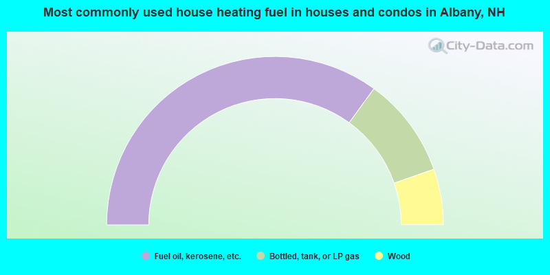
- 70.1%Fuel oil, kerosene, etc.
- 19.3%Bottled, tank, or LP gas
- 10.7%Wood
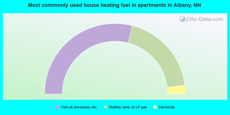
- 58.0%Fuel oil, kerosene, etc.
- 38.0%Bottled, tank, or LP gas
- 4.0%Electricity
Albany compared to New Hampshire state average:
- Median house value below state average.
- Unemployed percentage below state average.
- Black race population percentage below state average.
- Hispanic race population percentage significantly below state average.
- Foreign-born population percentage significantly below state average.
- Length of stay since moving in significantly above state average.
- Number of rooms per house significantly below state average.
- House age significantly below state average.
- Number of college students below state average.
- Percentage of population with a bachelor's degree or higher below state average.

|
Total of 3 patent applications in 2008-2024.