Manchester, Texas
Submit your own pictures of this place and show them to the world
- OSM Map
- General Map
- Google Map
- MSN Map

| Males: 426 | |
| Females: 427 |
| Median resident age: | 42.3 years |
| Texas median age: | 32.3 years |
Zip code: 75412
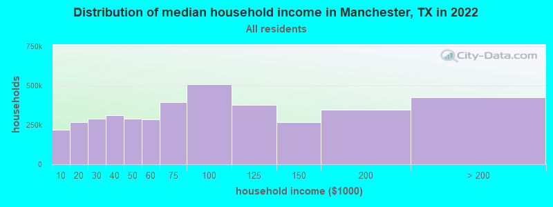
| Manchester: | $45,923 |
| TX: | $72,284 |
Estimated per capita income in 2022: $25,232 (it was $14,921 in 2000)
Manchester CCD income, earnings, and wages data
Estimated median house or condo value in 2022: $131,796 (it was $38,200 in 2000)
| Manchester: | $131,796 |
| TX: | $275,400 |
Mean prices in 2022: all housing units: $144,618; detached houses: $155,301; mobile homes: $98,537
Detailed information about poverty and poor residents in Manchester, TX


- 81787.6%White alone
- 828.8%Black alone
- 212.3%Hispanic
- 111.2%American Indian alone
- 20.2%Two or more races

Races in Manchester detailed stats: ancestries, foreign born residents, place of birth
 Recent articles from our blog. Our writers, many of them Ph.D. graduates or candidates, create easy-to-read articles on a wide variety of topics.
Current Local Time: CST time zone
Land area: 206.4 square miles.
Population density: 4.1 people per square mile (very low).

| Manchester CCD: | 0.9% ($352) |
| Texas: | 1.8% ($1,393) |
Nearest city with pop. 50,000+: East Grayson, TX (83.5 miles  , pop. 81,381).
Nearest city with pop. 200,000+: Plano, TX (108.7 miles , pop. 222,030).
Nearest city with pop. 1,000,000+: Dallas, TX (120.4 miles , pop. 1,188,580).
Nearest cities:
), Latitude: 33.85 N, Longitude: 95.12 W
Area code commonly used in this area: 580

| Here: | 4.0% |
| Texas: | 3.5% |
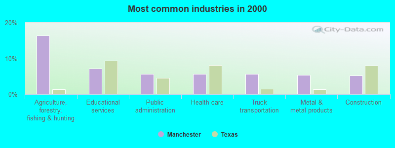
- Agriculture, forestry, fishing & hunting (16.5%)
- Educational services (7.1%)
- Public administration (5.6%)
- Health care (5.6%)
- Truck transportation (5.6%)
- Metal & metal products (5.4%)
- Construction (5.2%)
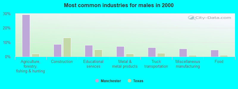
- Agriculture, forestry, fishing & hunting (29.5%)
- Construction (8.8%)
- Educational services (8.0%)
- Metal & metal products (7.2%)
- Truck transportation (6.4%)
- Miscellaneous manufacturing (5.6%)
- Food (4.8%)
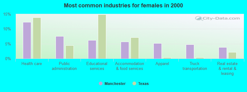
- Health care (12.3%)
- Public administration (7.6%)
- Educational services (6.2%)
- Accommodation & food services (5.7%)
- Apparel (5.2%)
- Truck transportation (4.7%)
- Real estate & rental & leasing (3.8%)
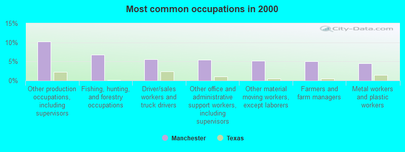
- Other production occupations, including supervisors (10.2%)
- Fishing, hunting, and forestry occupations (6.7%)
- Driver/sales workers and truck drivers (5.6%)
- Other office and administrative support workers, including supervisors (5.4%)
- Other material moving workers, except laborers (5.2%)
- Farmers and farm managers (5.0%)
- Metal workers and plastic workers (4.5%)

- Other production occupations, including supervisors (13.5%)
- Fishing, hunting, and forestry occupations (12.4%)
- Farmers and farm managers (8.4%)
- Agricultural workers, including supervisors (8.0%)
- Other material moving workers, except laborers (8.0%)
- Metal workers and plastic workers (6.4%)
- Driver/sales workers and truck drivers (6.4%)
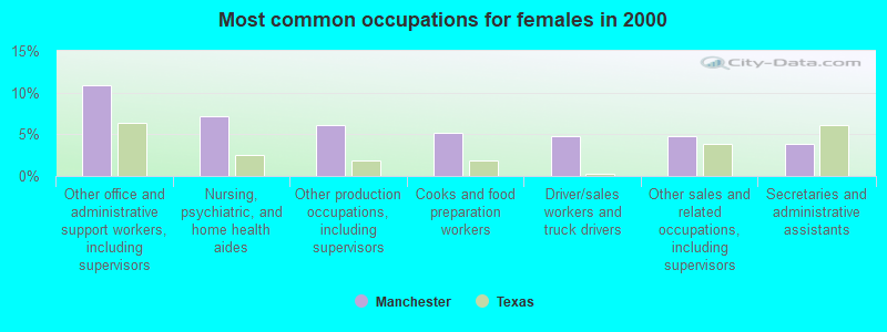
- Other office and administrative support workers, including supervisors (10.9%)
- Nursing, psychiatric, and home health aides (7.1%)
- Other production occupations, including supervisors (6.2%)
- Cooks and food preparation workers (5.2%)
- Driver/sales workers and truck drivers (4.7%)
- Other sales and related occupations, including supervisors (4.7%)
- Secretaries and administrative assistants (3.8%)
Average climate in Manchester, Texas
Based on data reported by over 4,000 weather stations


Tornado activity:
Manchester-area historical tornado activity is slightly above Texas state average. It is 85% greater than the overall U.S. average.
On 4/2/1982, a category F4 (max. wind speeds 207-260 mph) tornado 13.1 miles away from the Manchester place center killed 10 people and injured 170 people and caused between $5,000,000 and $50,000,000 in damages.
On 4/2/1982, a category F5 (max. wind speeds 261-318 mph) tornado 32.3 miles away from the place center injured 29 people and caused between $500,000 and $5,000,000 in damages.
Earthquake activity:
Manchester-area historical earthquake activity is significantly above Texas state average. It is 541% greater than the overall U.S. average.On 11/6/2011 at 03:53:10, a magnitude 5.7 (5.7 MW, Depth: 3.2 mi, Class: Moderate, Intensity: VI - VII) earthquake occurred 149.4 miles away from the city center
On 9/3/2016 at 12:02:44, a magnitude 5.8 (5.8 MW, Depth: 3.5 mi) earthquake occurred 205.6 miles away from Manchester center
On 11/7/2016 at 01:44:24, a magnitude 5.0 (5.0 MW, Depth: 2.8 mi) earthquake occurred 176.3 miles away from Manchester center
On 5/17/2012 at 08:12:00, a magnitude 4.8 (4.8 MW, Depth: 3.1 mi, Class: Light, Intensity: IV - V) earthquake occurred 139.8 miles away from Manchester center
On 11/8/2011 at 02:46:57, a magnitude 4.8 (4.8 MW, Depth: 3.1 mi) earthquake occurred 150.2 miles away from the city center
On 11/5/2011 at 07:12:45, a magnitude 4.8 (4.8 MW, Depth: 1.9 mi) earthquake occurred 150.3 miles away from the city center
Magnitude types: moment magnitude (MW)
Natural disasters:
The number of natural disasters in Red River County (16) is near the US average (15).Major Disasters (Presidential) Declared: 11
Emergencies Declared: 4
Causes of natural disasters: Floods: 8, Storms: 7, Tornadoes: 6, Hurricanes: 3, Fires: 2, Winds: 2, Winter Storms: 2, Heavy Rain: 1, Other: 1 (Note: some incidents may be assigned to more than one category).
Colleges/universities with over 2000 students nearest to Manchester:
- Paris Junior College (about 28 miles; Paris, TX; Full-time enrollment: 3,875)
- Northeast Texas Community College (about 54 miles; Mount Pleasant, TX; FT enrollment: 2,320)
- Texas A & M University-Commerce (about 62 miles; Commerce, TX; FT enrollment: 8,890)
- Texarkana College (about 67 miles; Texarkana, TX; FT enrollment: 2,629)
- Southeastern Oklahoma State University (about 73 miles; Durant, OK; FT enrollment: 3,365)
- Carl Albert State College (about 88 miles; Poteau, OK; FT enrollment: 2,041)
- Grayson College (about 88 miles; Denison, TX; FT enrollment: 2,496)
Points of interest:
Churches in Manchester include: Siloam Church (A), Pine Hill Church (B), Bartonville Church (C), Bible Way Church (D), Riverside Church (E), Greenwood Church (F), Kiomatia Church (G), Leesville Church (H). Display/hide their locations on the map
Cemeteries: Tinsley Cemetery (1), Pine Hill Cemetery (2), Calhoun Cemetery (3), Woodland Cemetery (4), Albion Cemetery (5), Haley Cemetery (6), Tuggle Springs Cemetery (7). Display/hide their locations on the map
Lakes and reservoirs: Wright Lake (A), Flag Pond (B), Mud Lake (C), Cowper Lake (D), Rogers Lake (E), Hall Lake (F), Igo Lake Number 2 (G), Tallant Lake (H). Display/hide their locations on the map
Streams, rivers, and creeks: Tanyard Creek (A), Salt Well Slough (B), Pond Creek (C), Pine Creek (D), Little Pine Branch (E), Lick Creek (F), First Pecan Bayou (G). Display/hide their locations on the map
| This place: | 2.3 people |
| Texas: | 2.8 people |
| This place: | 66.5% |
| Whole state: | 69.9% |
| This place: | 4.2% |
| Whole state: | 6.0% |
No gay or lesbian households reported
| This place: | 15.0% |
| Whole state: | 15.4% |
| This place: | 5.8% |
| Whole state: | 6.7% |
For population 15 years and over in Manchester:
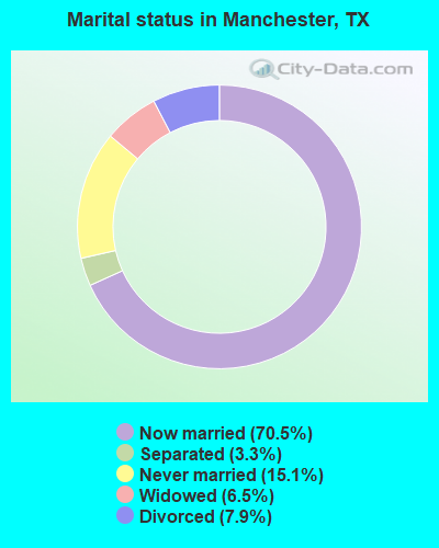
- Never married: 15.1%
- Now married: 70.5%
- Separated: 3.3%
- Widowed: 6.5%
- Divorced: 7.9%
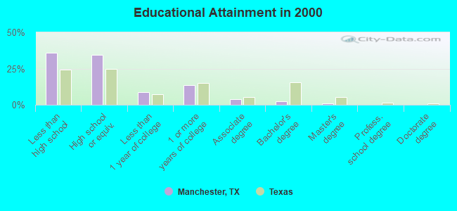
For population 25 years and over in Manchester:
- High school or higher: 64.3%
- Bachelor's degree or higher: 3.6%
- Graduate or professional degree: 1.2%
- Unemployed: 5.5%
- Mean travel time to work (commute): 42.3 minutes
| Here: | 11.5 |
| Texas average: | 15.6 |

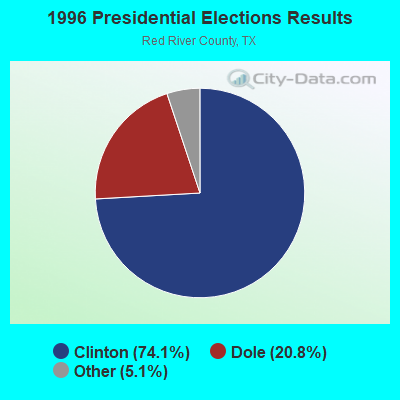
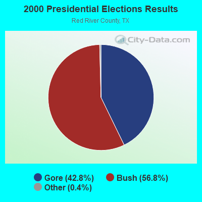
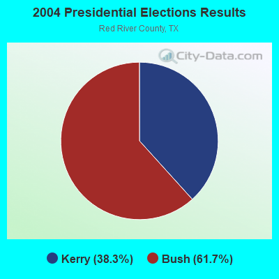
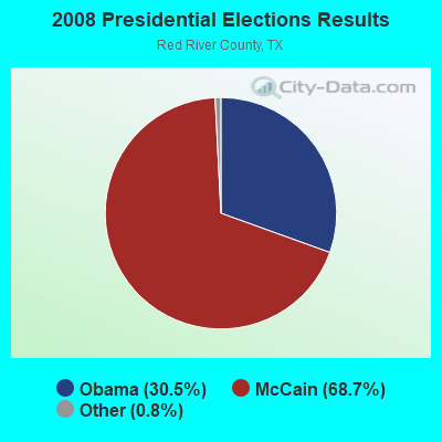
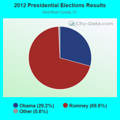

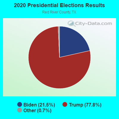
Graphs represent county-level data. Detailed 2008 Election Results
Religion statistics for Manchester, TX (based on Red River County data)
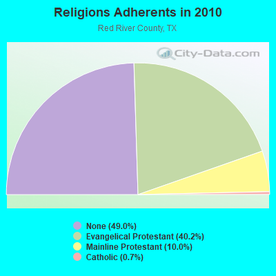
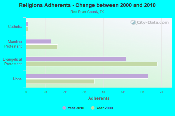
| Religion | Adherents | Congregations |
|---|---|---|
| Evangelical Protestant | 5,169 | 40 |
| Mainline Protestant | 1,291 | 17 |
| Catholic | 92 | 1 |
| Other | 1 | 1 |
| None | 6,307 | - |
Food Environment Statistics:
| Red River County: | 3.82 / 10,000 pop. |
| State: | 1.47 / 10,000 pop. |
| Red River County: | 1.53 / 10,000 pop. |
| Texas: | 1.11 / 10,000 pop. |
| This county: | 6.88 / 10,000 pop. |
| Texas: | 3.95 / 10,000 pop. |
| Red River County: | 6.88 / 10,000 pop. |
| Texas: | 6.13 / 10,000 pop. |
| Red River County: | 12.0% |
| Texas: | 8.9% |
| Red River County: | 27.3% |
| Texas: | 26.6% |
| Red River County: | 15.0% |
| Texas: | 15.7% |
Strongest AM radio stations in Manchester:
- KEEL (710 AM; 50 kW; SHREVEPORT, LA; Owner: CITICASTERS LICENSES, L.P.)
- KFXR (1190 AM; 50 kW; DALLAS, TX; Owner: CLEAR CHANNEL BROADCASTING LICENSES, INC.)
- KWKH (1130 AM; 50 kW; SHREVEPORT, LA; Owner: CITICASTERS LICENSES, L.P.)
- KRLD (1080 AM; 50 kW; DALLAS, TX; Owner: TEXAS INFINITY BROADCASTING L.P.)
- WBAP (820 AM; 50 kW; FORT WORTH, TX; Owner: WBAP-KSCS OPERATING, LTD.)
- KBEL (1240 AM; 1 kW; IDABEL, OK; Owner: HAROLD E. COCHRAN)
- KRMG (740 AM; 50 kW; TULSA, OK; Owner: CXR HOLDINGS, INC.)
- KSKY (660 AM; 20 kW; BALCH SPRINGS, TX; Owner: BISON MEDIA, INC.)
- KESS (1270 AM; 50 kW; FORT WORTH, TX; Owner: KESS-AM LICENSE CORP.)
- KZMP (1540 AM; 50 kW; UNIVERSITY PARK, TX; Owner: ENTRAVISION HOLDINGS, LLC)
- KPYN (900 AM; 10 kW; ATLANTA, TX; Owner: FAMILY WORSHIP CENTER CHURCH, INC.)
- KGHT (880 AM; 50 kW; SHERIDAN, AR; Owner: METROPOLITAN RADIO GROUP, INC.)
- KAHZ (1360 AM; 50 kW; HURST, TX)
Strongest FM radio stations in Manchester:
- KPLT-FM (107.7 FM; PARIS, TX; Owner: EAST TEXAS BROADCASTING, INC.)
- KBUS (101.9 FM; PARIS, TX; Owner: EAST TEXAS BROADCASTING, INC.)
- KOYN (93.9 FM; PARIS, TX; Owner: EAST TEXAS BROADCASTING, INC.)
- KITX (95.5 FM; HUGO, OK; Owner: K95.5, INC.)
- KKBI (106.1 FM; BROKEN BOW, OK; Owner: J.D.C. RADIO, INC.)
- KGAP (98.5 FM; CLARKSVILLE, TX; Owner: PETRACOM OF TEXARKANA, L.L.C.)
- KQIB (102.9 FM; IDABEL, OK; Owner: JDC RADIO, INC.)
- KHCP (89.3 FM; PARIS, TX; Owner: HOUSTON CHRISTIAN BROADCASTERS, INC.)
- KBEL-FM (96.7 FM; IDABEL, OK; Owner: HAROLD E. COCHRAN)
- KXRT (90.9 FM; IDABEL, OK; Owner: AMERICAN FAMILY ASSOCIATION)
TV broadcast stations around Manchester:
- K63BA (Channel 63; IDABEL, OK; Owner: OKLAHOMA EDUCATIONAL TELEVISION AUTHORITY)
- K28DJ (Channel 28; BROKEN BOW, OK; Owner: TRUSTEES OF J.B.CALLAHAM R.T.)
- K42DA (Channel 42; PARIS, TX; Owner: TRINITY BROADCASTING NETWORK)
- K15AA (Channel 15; HUGO, OK; Owner: OKLAHOMA EDUCATIONAL TELEVISION AUTHORITY)
FCC Registered Antenna Towers:
4- Larry Jenkins, 600' North Of Cr 2347 On The East Side Of Fm 195 (Lat: 33.844056 Lon: -95.161500), Type: 91.4, Structure height: 48387 m, Overall height: 91.4 m, Registrant: Sooner Services, Larrygjenkins@gmail.Com, , Winch-ester, Phone: (405) 818-0541
- Larry Jenkins, 600' North Of Cr 2347 On The East Side Of Fm 195 (Lat: 33.844056 Lon: -95.161500), Type: 91.4, Structure height: 48387 m, Overall height: 91.4 m, Registrant: Sooner Services, Larrygjenkins@gmail.Com, , Winch-ester, Phone: (405) 818-0541
- Mark Dameron, 600' North Of Cr 2347 On The East Side Of Fm 195 (Lat: 33.844056 Lon: -95.161500), Type: 91.4, Structure height: 48387 m, Overall height: 91.4 m, Registrant: Sooner Services, Larrygjenkins@gmail.Com, , Winch-ester, Phone: (405) 818-0541
- Mark A Dameron, 600' North Of Cr 2347 On The East Side Of Fm 195 (Lat: 33.844056 Lon: -95.161500), Type: 91.4, Structure height: 48387 m, Overall height: 91.4 m, Registrant: Sooner Services, Larrygjenkins@gmail.Com, , Winch-ester, Phone: (405) 818-0541
FCC Registered Microwave Towers:
9 (See the full list of FCC Registered Microwave Towers in this town)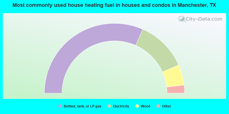
- 63.3%Bottled, tank, or LP gas
- 23.5%Electricity
- 9.6%Wood
- 3.1%Utility gas
- 0.6%Other fuel
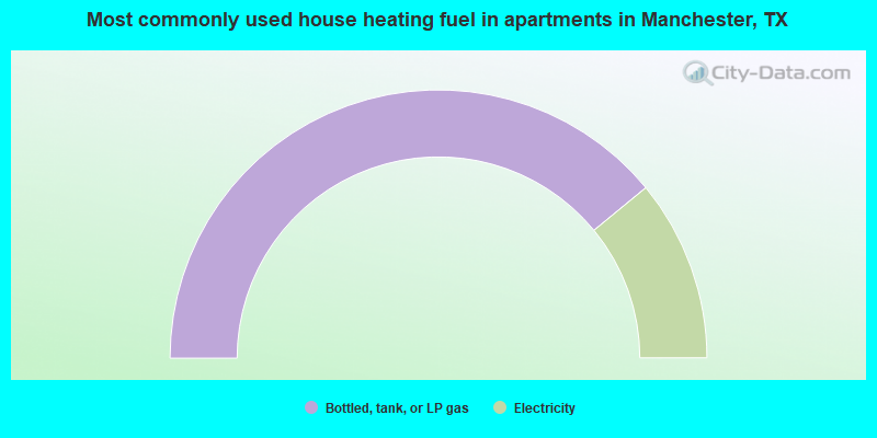
- 78.1%Bottled, tank, or LP gas
- 21.9%Electricity
Manchester compared to Texas state average:
- Median household income below state average.
- Median house value below state average.
- Unemployed percentage below state average.
- Hispanic race population percentage significantly below state average.
- Median age significantly above state average.
- Foreign-born population percentage significantly below state average.
- Renting percentage significantly below state average.
- Length of stay since moving in significantly above state average.
- Number of rooms per house significantly below state average.
- House age significantly below state average.
- Number of college students significantly below state average.
- Percentage of population with a bachelor's degree or higher significantly below state average.