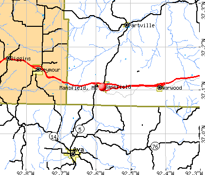
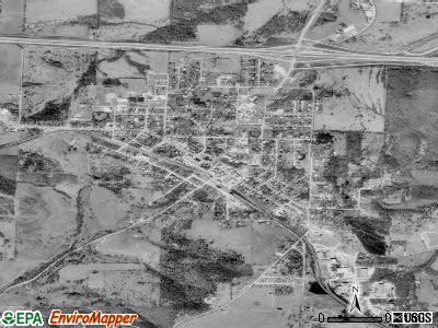
Mansfield, Missouri
Submit your own pictures of this city and show them to the world
- OSM Map
- General Map
- Google Map
- MSN Map
Population change since 2000: -6.2%
 |
| Males: 566 | |
| Females: 699 |
| Median resident age: | 29.0 years |
| Missouri median age: | 39.1 years |
Zip codes: 65704.
| Mansfield: | $30,351 |
| MO: | $64,811 |
Estimated per capita income in 2022: $18,095 (it was $11,303 in 2000)
Mansfield city income, earnings, and wages data
Estimated median house or condo value in 2022: $102,613 (it was $47,600 in 2000)
| Mansfield: | $102,613 |
| MO: | $221,200 |
Mean prices in 2022: all housing units: $133,882; detached houses: $138,065; mobile homes: $35,281
Median gross rent in 2022: $341.
(31.7% for White Non-Hispanic residents, 25.0% for two or more races residents)
Detailed information about poverty and poor residents in Mansfield, MO


Compare current foreclosures near Mansfield, MO:
| Photo | Address | Area | Beds / Baths | Price | Details |
|---|---|---|---|---|---|

|
#1
N Julie Ave
Mansfield, MO 65704
|
- sq. feet
|
2 baths 3 beds |
show details | |

|
#2
N Hamilton Ave Apt 3
Mansfield, MO 65704
|
- sq. feet
|
- baths - beds |
show details | |

|
#3
E Summit Ave
Seymour, MO 65746
|
1,863 sq. feet
|
2 baths 4 beds |
show details | |

|
#4
State Highway O
Seymour, MO 65746
|
- sq. feet
|
- baths - beds |
show details | |

|
#5
Cross Creek Rd
Marshfield, MO 65706
|
- sq. feet
|
- baths - beds |
show details | |

|
#6
Boardwalk
Seymour, MO 65746
|
- sq. feet
|
- baths - beds |
show details | |

|
#7
Guthery St
Ava, MO 65608
|
- sq. feet
|
- baths - beds |
show details | |

|
#8
Newkirk Rd
Mountain Grove, MO 65711
|
- sq. feet
|
- baths - beds |
show details | |

|
#9
W Washington Ave
Ava, MO 65608
|
- sq. feet
|
- baths - beds |
show details | |

|
#10
6 6761
Ava, MO 65608
|
- sq. feet
|
- baths - beds |
show details |
| Photo | Address | Area | Beds / Baths | Price | Details |
|---|---|---|---|---|---|

|
#11
4 1001a
Ava, MO 65608
|
- sq. feet
|
- baths - beds |
show details | |

|
#12
3 66
Ava, MO 65608
|
- sq. feet
|
- baths - beds |
show details | |

|
#13
Highway Z
Hartville, MO 65667
|
- sq. feet
|
- baths - beds |
show details | |

|
#14
P Rd
Seymour, MO 65746
|
- sq. feet
|
- baths - beds |
show details | |

|
#15
S Cordie St
Seymour, MO 65746
|
- sq. feet
|
- baths - beds |
show details | |

|
#16
State Highway O
Seymour, MO 65746
|
- sq. feet
|
- baths - beds |
show details | |

|
#17
Short State Highway P
Seymour, MO 65746
|
- sq. feet
|
- baths - beds |
show details | |

|
#18
S Lorraine St
Seymour, MO 65746
|
- sq. feet
|
- baths - beds |
show details | |

|
#19
S Division St
Seymour, MO 65746
|
- sq. feet
|
- baths - beds |
show details | |

|
#20
Highway Y
Hartville, MO 65667
|
- sq. feet
|
- baths - beds |
show details |
| Photo | Address | Area | Beds / Baths | Price | Details |
|---|---|---|---|---|---|

|
Check over 1 million property listings on Foreclosure.com!
|
browse all offers | |||
| Photo | Address | Area | Beds / Baths | Price | Details |
|---|


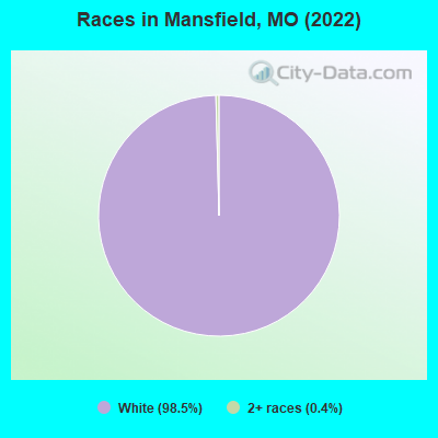
- 1,33598.5%White alone
- 50.4%Two or more races
Races in Mansfield detailed stats: ancestries, foreign born residents, place of birth
According to our research of Missouri and other state lists, there were 25 registered sex offenders living in Mansfield, Missouri as of April 26, 2024.
The ratio of all residents to sex offenders in Mansfield is 51 to 1.
Type |
2009 |
2010 |
2011 |
2012 |
2013 |
2014 |
2015 |
2016 |
2017 |
2018 |
2019 |
2020 |
2021 |
2022 |
|---|---|---|---|---|---|---|---|---|---|---|---|---|---|---|
| Murders (per 100,000) | 0 (0.0) | 0 (0.0) | 0 (0.0) | 1 (77.4) | 0 (0.0) | 0 (0.0) | 0 (0.0) | 0 (0.0) | 0 (0.0) | 0 (0.0) | 0 (0.0) | 0 (0.0) | 0 (0.0) | 0 (0.0) |
| Rapes (per 100,000) | 0 (0.0) | 0 (0.0) | 0 (0.0) | 1 (77.4) | 0 (0.0) | 0 (0.0) | 0 (0.0) | 0 (0.0) | 0 (0.0) | 2 (160.1) | 2 (160.0) | 0 (0.0) | 0 (0.0) | 1 (79.4) |
| Robberies (per 100,000) | 0 (0.0) | 0 (0.0) | 0 (0.0) | 0 (0.0) | 0 (0.0) | 0 (0.0) | 0 (0.0) | 0 (0.0) | 2 (159.4) | 0 (0.0) | 0 (0.0) | 0 (0.0) | 0 (0.0) | 0 (0.0) |
| Assaults (per 100,000) | 0 (0.0) | 2 (154.3) | 1 (76.9) | 1 (77.4) | 2 (156.2) | 3 (236.2) | 2 (159.6) | 0 (0.0) | 2 (159.4) | 1 (80.1) | 2 (160.0) | 0 (0.0) | 5 (403.2) | 3 (238.3) |
| Burglaries (per 100,000) | 8 (586.9) | 10 (771.6) | 12 (922.4) | 15 (1,161) | 7 (546.9) | 10 (787.4) | 11 (877.9) | 11 (877.2) | 6 (478.1) | 7 (560.4) | 4 (320.0) | 7 (564.5) | 1 (80.6) | 0 (0.0) |
| Thefts (per 100,000) | 20 (1,467) | 40 (3,086) | 64 (4,919) | 57 (4,412) | 55 (4,297) | 73 (5,748) | 63 (5,028) | 69 (5,502) | 84 (6,693) | 79 (6,325) | 84 (6,720) | 47 (3,790) | 28 (2,258) | 12 (953.1) |
| Auto thefts (per 100,000) | 1 (73.4) | 0 (0.0) | 0 (0.0) | 0 (0.0) | 2 (156.2) | 2 (157.5) | 2 (159.6) | 2 (159.5) | 4 (318.7) | 6 (480.4) | 5 (400.0) | 2 (161.3) | 2 (161.3) | 0 (0.0) |
| Arson (per 100,000) | 0 (0.0) | 0 (0.0) | 0 (0.0) | 0 (0.0) | 0 (0.0) | 0 (0.0) | 0 (0.0) | 0 (0.0) | 0 (0.0) | 0 (0.0) | 0 (0.0) | 0 (0.0) | 0 (0.0) | 1 (79.4) |
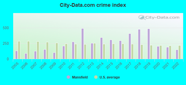
| City-Data.com crime index | 105.6 | 208.3 | 276.7 | 489.9 | 253.9 | 344.9 | 307.3 | 294.3 | 406.4 | 474.8 | 483.2 | 204.0 | 189.5 | 149.3 |
The City-Data.com crime index weighs serious crimes and violent crimes more heavily. Higher means more crime, U.S. average is 246.1. It adjusts for the number of visitors and daily workers commuting into cities.
Crime rate in Mansfield detailed stats: murders, rapes, robberies, assaults, burglaries, thefts, arson
Full-time law enforcement employees in 2020, including police officers: 5 (5 officers - 5 male; 0 female).
| Officers per 1,000 residents here: | 4.03 |
| Missouri average: | 2.53 |
 Recent articles from our blog. Our writers, many of them Ph.D. graduates or candidates, create easy-to-read articles on a wide variety of topics.

 | ISP in rural areas near Mansfield, Cabool, Mt. Grove (5 replies) |
| Missouri Outlaw History (3407 replies) |
| Interesting Missouri facts. (1186 replies) |
| Rural areas around Springfield (16 replies) |
| Rams are gone. Once again, St. Louis is not an NFL (119 replies) |
| Oh, to be in MO, now that spring is here (34 replies) |
Latest news from Mansfield, MO collected exclusively by city-data.com from local newspapers, TV, and radio stations
Mansfield, MO City Guides:
Ancestries: American (16.0%), Irish (16.0%), German (13.2%), English (12.1%), European (9.0%), French (5.9%).
Current Local Time: CST time zone
Incorporated in 1900
Elevation: 1488 feet
Land area: 1.57 square miles.
Population density: 806 people per square mile (low).
4 residents are foreign born
| This city: | 0.3% |
| Missouri: | 4.2% |
Median real estate property taxes paid for housing units with mortgages in 2022: $542 (0.5%)
Median real estate property taxes paid for housing units with no mortgage in 2022: $679 (0.7%)
Nearest city with pop. 50,000+: Springfield, MO  (39.4 miles , pop. 151,580).
Nearest city with pop. 200,000+: St. Louis, MO (165.4 miles , pop. 348,189).
Nearest city with pop. 1,000,000+: Dallas, TX (381.5 miles , pop. 1,188,580).
Nearest cities:
Latitude: 37.11 N, Longitude: 92.58 W
Area code: 417
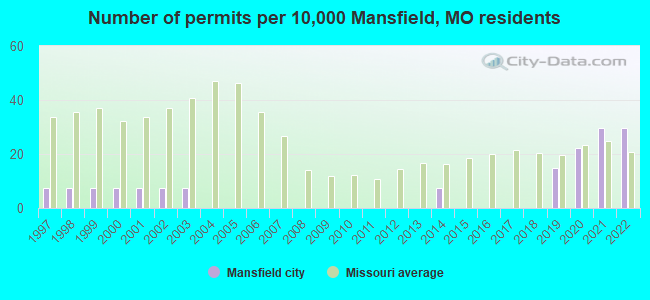
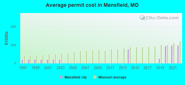
Single-family new house construction building permits:
- 2022: 4 buildings, average cost: $243,000
- 2021: 4 buildings, average cost: $243,000
- 2020: 3 buildings, average cost: $237,700
- 2019: 2 buildings, average cost: $64,000
- 2014: 1 building, cost: $194,700
- 2003: 1 building, cost: $54,300
- 2002: 1 building, cost: $54,300
- 2001: 1 building, cost: $54,300
- 2000: 1 building, cost: $54,300
- 1999: 1 building, cost: $54,300
- 1998: 1 building, cost: $54,300
- 1997: 1 building, cost: $54,300
| Here: | 2.9% |
| Missouri: | 2.8% |
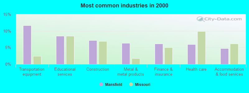
- Transportation equipment (11.6%)
- Educational services (8.5%)
- Construction (7.2%)
- Metal & metal products (6.3%)
- Finance & insurance (6.2%)
- Health care (6.0%)
- Accommodation & food services (4.8%)
- Transportation equipment (19.3%)
- Construction (13.0%)
- Metal & metal products (11.0%)
- Wood products (4.3%)
- Repair & maintenance (4.3%)
- Motor vehicle & parts dealers (4.0%)
- Truck transportation (4.0%)
- Educational services (14.9%)
- Health care (11.2%)
- Finance & insurance (11.2%)
- Social assistance (9.0%)
- Food & beverage stores (9.0%)
- Accommodation & food services (8.6%)
- Miscellaneous manufacturing (3.4%)
- Metal workers and plastic workers (9.9%)
- Vehicle and mobile equipment mechanics, installers, and repairers (5.1%)
- Cashiers (4.6%)
- Building and grounds cleaning and maintenance occupations (4.6%)
- Other production occupations, including supervisors (4.4%)
- Laborers and material movers, hand (4.0%)
- Child care workers (3.9%)
- Metal workers and plastic workers (17.0%)
- Vehicle and mobile equipment mechanics, installers, and repairers (8.7%)
- Driver/sales workers and truck drivers (6.7%)
- Other production occupations, including supervisors (6.7%)
- Laborers and material movers, hand (6.0%)
- Electrical equipment mechanics and other installation, maintenance, and repair workers, including supervisors (4.0%)
- Pipelayers, plumbers, pipefitters, and steamfitters (3.3%)
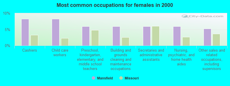
- Cashiers (8.2%)
- Child care workers (8.2%)
- Preschool, kindergarten, elementary, and middle school teachers (6.0%)
- Building and grounds cleaning and maintenance occupations (6.0%)
- Secretaries and administrative assistants (6.0%)
- Nursing, psychiatric, and home health aides (6.0%)
- Other sales and related occupations, including supervisors (5.2%)
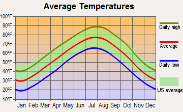
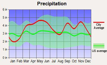
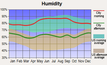
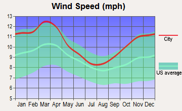
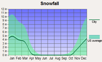
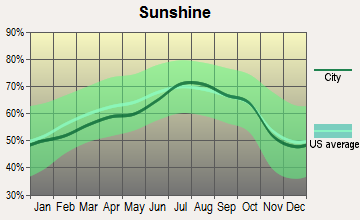
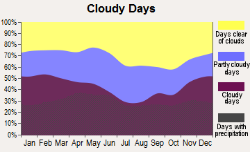
Average climate in Mansfield, Missouri
Based on data reported by over 4,000 weather stations
|
|


Tornado activity:
Mansfield-area historical tornado activity is slightly below Missouri state average. It is 26% greater than the overall U.S. average.
On 9/26/1959, a category F4 (max. wind speeds 207-260 mph) tornado 17.5 miles away from the Mansfield city center caused between $50,000 and $500,000 in damages.
On 3/25/1954, a category F4 tornado 24.3 miles away from the city center killed 2 people and caused between $5000 and $50,000 in damages.
Earthquake activity:
Mansfield-area historical earthquake activity is significantly above Missouri state average. It is 518% greater than the overall U.S. average.On 9/3/2016 at 12:02:44, a magnitude 5.8 (5.8 MW, Depth: 3.5 mi, Class: Moderate, Intensity: VI - VII) earthquake occurred 245.5 miles away from the city center
On 11/6/2011 at 03:53:10, a magnitude 5.7 (5.7 MW, Depth: 3.2 mi) earthquake occurred 257.3 miles away from the city center
On 5/4/1991 at 01:18:54, a magnitude 5.0 (4.4 MB, 4.6 LG, 5.0 LG, Depth: 3.1 mi) earthquake occurred 157.2 miles away from Mansfield center
On 3/25/1976 at 00:41:20, a magnitude 5.0 (4.9 MB, 5.0 LG) earthquake occurred 161.5 miles away from Mansfield center
On 9/26/1990 at 13:18:51, a magnitude 5.0 (4.7 MB, 4.8 LG, 5.0 LG, Depth: 7.7 mi) earthquake occurred 168.0 miles away from the city center
On 2/28/2011 at 05:00:50, a magnitude 4.7 (4.7 MW, Depth: 2.0 mi, Class: Light, Intensity: IV - V) earthquake occurred 127.7 miles away from the city center
Magnitude types: regional Lg-wave magnitude (LG), body-wave magnitude (MB), moment magnitude (MW)
Natural disasters:
The number of natural disasters in Wright County (22) is greater than the US average (15).Major Disasters (Presidential) Declared: 13
Emergencies Declared: 6
Causes of natural disasters: Floods: 15, Storms: 14, Tornadoes: 11, Winds: 6, Winter Storms: 5, Drought: 1, Hurricane: 1, Other: 1 (Note: some incidents may be assigned to more than one category).

Hospitals and medical centers in Mansfield:
Airports located in Mansfield:
- Mansfield Municipal Airport (03B) (Runways: 1, Itinerant Ops: 630, Local Ops: 392, Military Ops: 15)
Colleges/universities with over 2000 students nearest to Mansfield:
- Evangel University (about 39 miles; Springfield, MO; Full-time enrollment: 2,036)
- Missouri State University-Springfield (about 39 miles; Springfield, MO; FT enrollment: 16,660)
- Ozarks Technical Community College (about 40 miles; Springfield, MO; FT enrollment: 10,356)
- Drury University (about 40 miles; Springfield, MO; FT enrollment: 3,902)
- Southwest Baptist University (about 58 miles; Bolivar, MO; FT enrollment: 2,783)
- Missouri University of Science and Technology (about 74 miles; Rolla, MO; FT enrollment: 6,486)
- Crowder College (about 101 miles; Neosho, MO; FT enrollment: 3,675)
Public high school in Mansfield:
- MANSFIELD HIGH (Students: 209, Location: 315 W OHIO ST, Grades: 9-12)
Public elementary/middle schools in Mansfield:
- WILDER ELEM. (Students: 357, Location: 414 W OHIO ST, Grades: PK-5)
- MANSFIELD JR. HIGH (Students: 167, Location: 316 W OHIO ST, Grades: 6-8)
Points of interest:
Notable locations in Mansfield: Mansfield Fire Department (A), Department of Conservation Ozark Field Fire Office Mansfield (B). Display/hide their locations on the map
Tourist attraction: Mannfield Area Historical Society & Museum (Cultural Attractions- Events- & Facilities; 111 West Park Square).
Hotel: Little House Inn (880 West Commercial Street).
Court: Douglas County - Circuit Court- Judge (101 North Madison Avenue).
| This city: | 2.3 people |
| Missouri: | 2.5 people |
| This city: | 56.7% |
| Whole state: | 65.3% |
| This city: | 7.4% |
| Whole state: | 6.7% |
Likely homosexual households (counted as self-reported same-sex unmarried-partner households)
- Lesbian couples: 0.0% of all households
- Gay men: 0.4% of all households
Banks with branches in Mansfield (2011 data):
- HomePride Bank: Homepride Bank at 110 East Commercial, branch established on 1892/03/03. Info updated 2011/10/28: Bank assets: $79.3 mil, Deposits: $71.3 mil, local headquarters, positive income, 4 total offices, Holding Company: Banc 60, Inc.
- Great Southern Bank: Mansfield Branch at 705 N. Business Hwy 60, branch established on 1908/04/08. Info updated 2012/02/03: Bank assets: $3,788.7 mil, Deposits: $2,986.3 mil, headquarters in Reeds Spring, MO, positive income, Commercial Lending Specialization, 109 total offices, Holding Company: Great Southern Bancorp, Inc.
For population 15 years and over in Mansfield:
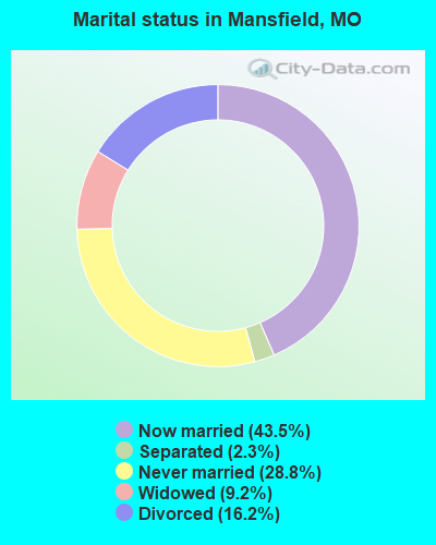
- Never married: 28.8%
- Now married: 43.5%
- Separated: 2.3%
- Widowed: 9.2%
- Divorced: 16.2%
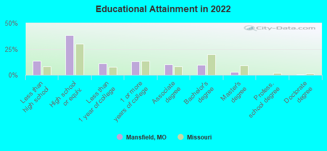
For population 25 years and over in Mansfield:
- High school or higher: 85.7%
- Bachelor's degree or higher: 13.2%
- Graduate or professional degree: 3.6%
- Unemployed: 5.8%
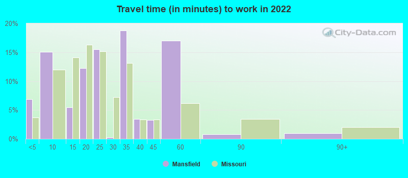
- Mean travel time to work (commute): 15.9 minutes
| Here: | 9.4 |
| Missouri average: | 11.1 |
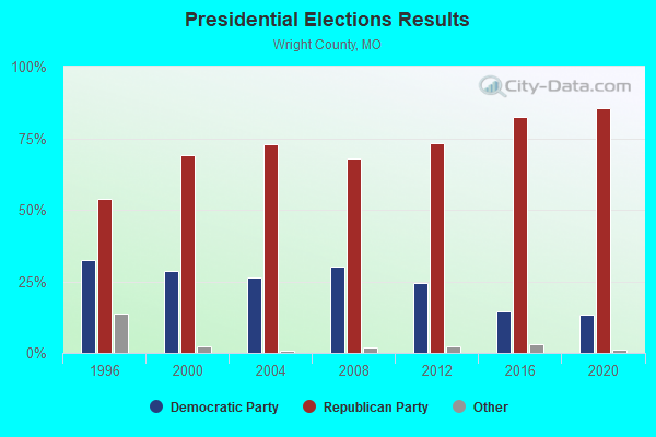
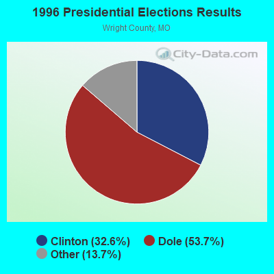


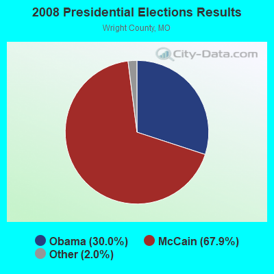
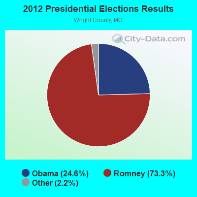
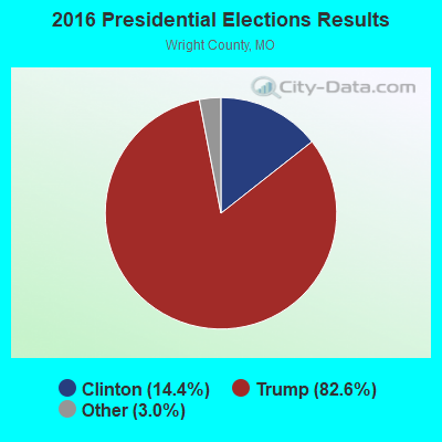
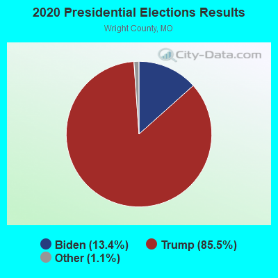
Graphs represent county-level data. Detailed 2008 Election Results
Religion statistics for Mansfield, MO (based on Wright County data)
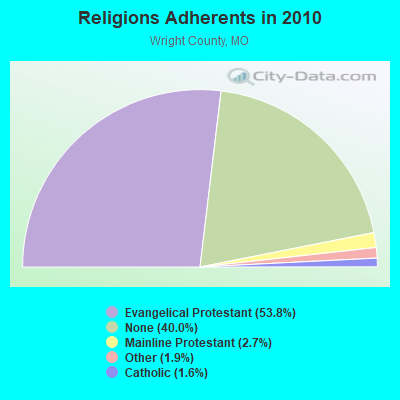
| Religion | Adherents | Congregations |
|---|---|---|
| Evangelical Protestant | 10,116 | 60 |
| Mainline Protestant | 509 | 5 |
| Other | 361 | 2 |
| Catholic | 304 | 2 |
| None | 7,525 | - |
Food Environment Statistics:
| Here: | 3.29 / 10,000 pop. |
| State: | 1.88 / 10,000 pop. |
| Here: | 0.55 / 10,000 pop. |
| Missouri: | 0.18 / 10,000 pop. |
| Here: | 0.55 / 10,000 pop. |
| Missouri: | 0.60 / 10,000 pop. |
| Here: | 7.67 / 10,000 pop. |
| Missouri: | 4.34 / 10,000 pop. |
| Wright County: | 7.12 / 10,000 pop. |
| Missouri: | 7.37 / 10,000 pop. |
| This county: | 9.0% |
| Missouri: | 8.8% |
| Wright County: | 29.6% |
| Missouri: | 29.6% |
| Wright County: | 9.7% |
| Missouri: | 13.5% |
Health and Nutrition:
| Mansfield: | 47.6% |
| Missouri: | 50.9% |
| This city: | 40.6% |
| Missouri: | 48.6% |
| Mansfield: | 28.8 |
| State: | 28.7 |
| Mansfield: | 20.0% |
| State: | 20.6% |
| This city: | 15.3% |
| Missouri: | 10.1% |
| Mansfield: | 6.8 |
| Missouri: | 6.8 |
| Mansfield: | 34.8% |
| Missouri: | 34.3% |
| Mansfield: | 52.1% |
| Missouri: | 57.5% |
| This city: | 75.1% |
| Missouri: | 79.3% |
More about Health and Nutrition of Mansfield, MO Residents
| Local government employment and payroll (March 2022) | |||||
| Function | Full-time employees | Monthly full-time payroll | Average yearly full-time wage | Part-time employees | Monthly part-time payroll |
|---|---|---|---|---|---|
| Police Protection - Officers | 3 | $15,364 | $61,456 | 0 | $0 |
| Financial Administration | 2 | $7,114 | $42,684 | 0 | $0 |
| Water Supply | 1 | $5,129 | $61,548 | 0 | $0 |
| Other and Unallocable | 1 | $3,037 | $36,444 | 0 | $0 |
| Streets and Highways | 1 | $1,418 | $17,016 | 0 | $0 |
| Electric Power | 1 | $4,533 | $54,396 | 0 | $0 |
| Sewerage | 1 | $5,912 | $70,944 | 0 | $0 |
| Other Government Administration | 0 | $0 | 3 | $3,241 | |
| Firefighters | 0 | $0 | 2 | $3,250 | |
| Fire - Other | 0 | $0 | 1 | $663 | |
| Judicial and Legal | 0 | $0 | 1 | $800 | |
| Parks and Recreation | 0 | $0 | 1 | $727 | |
| Totals for Government | 10 | $42,507 | $51,008 | 8 | $8,682 |
Mansfield government finances - Expenditure in 2017 (per resident):
- Current Operations - Police Protection: $275,000 ($217.39)
Water Utilities: $192,000 ($151.78)
Financial Administration: $179,000 ($141.50)
Local Fire Protection: $65,000 ($51.38)
Regular Highways: $33,000 ($26.09)
Parks and Recreation: $11,000 ($8.70)
Judicial and Legal Services: $4,000 ($3.16)
- General - Interest on Debt: $22,000 ($17.39)
- Total Salaries and Wages: $69,000 ($54.55)
Mansfield government finances - Revenue in 2017 (per resident):
- Charges - Sewerage: $239,000 ($188.93)
Solid Waste Management: $150,000 ($118.58)
Parks and Recreation: $7,000 ($5.53)
- Miscellaneous - Fines and Forfeits: $5,000 ($3.95)
Rents: $1,000 ($0.79)
- Revenue - Electric Utilities: $1,952,000 ($1543.08)
Water Utilities: $250,000 ($197.63)
- State Intergovernmental - Highways: $52,000 ($41.11)
- Tax - General Sales and Gross Receipts: $230,000 ($181.82)
Property: $91,000 ($71.94)
Other License: $26,000 ($20.55)
Occupation and Business License - Other: $13,000 ($10.28)
Public Utilities Sales: $6,000 ($4.74)
Mansfield government finances - Debt in 2017 (per resident):
- Long Term Debt - Beginning Outstanding - Unspecified Public Purpose: $553,000 ($437.15)
Outstanding Unspecified Public Purpose: $533,000 ($421.34)
Retired Unspecified Public Purpose: $20,000 ($15.81)
Mansfield government finances - Cash and Securities in 2017 (per resident):
- Other Funds - Cash and Securities: $1,661,000 ($1313.04)
Businesses in Mansfield, MO
- H&R Block: 1
- Subway: 1
- U-Haul: 1
Strongest AM radio stations in Mansfield:
- KWTO (560 AM; 5 kW; SPRINGFIELD, MO; Owner: KWTO, INC.)
- KMRF (1510 AM; daytime; 5 kW; MARSHFIELD, MO; Owner: NEW LIFE EVANGELISTIC CENTER, INC.)
- KBNN (750 AM; daytime; 5 kW; LEBANON, MO; Owner: OZARK BROADCASTING, INC.)
- KSGF (1260 AM; 5 kW; SPRINGFIELD, MO; Owner: JOURNAL BROADCAST CORPORATION)
- KELE (1360 AM; 1 kW; MOUNTAIN GROVE, MO; Owner: QUORUM RADIO PARTNERS, INC.)
- KKOZ (1430 AM; 0 kW; AVA, MO; Owner: CORUM INDUSTRIES, INC)
- KGHT (880 AM; 50 kW; SHERIDAN, AR; Owner: METROPOLITAN RADIO GROUP, INC.)
- KLFJ (1550 AM; 5 kW; SPRINGFIELD, MO; Owner: 127, INC.)
- KRMS (1150 AM; 10 kW; OSAGE BEACH, MO; Owner: VIPER COMMUNICATIONS, INC)
- WHB (810 AM; 50 kW; KANSAS CITY, MO; Owner: UNION BROADCASTING, INC.)
- WCRV (640 AM; 50 kW; COLLIERVILLE, TN; Owner: BOTT BROADCASTING COMPANY/TENNESSEE)
- KXEN (1010 AM; 50 kW; FESTUS-ST. LOUIS, MO; Owner: BDJ RADIO ENTERPRISES, LLC)
- KAAY (1090 AM; 50 kW; LITTLE ROCK, AR; Owner: CITADEL BROADCASTING COMPANY)
Strongest FM radio stations in Mansfield:
- KTXR (101.3 FM; SPRINGFIELD, MO; Owner: STEREO BROADCASTING, INC.)
- KTRI-FM (95.9 FM; MANSFIELD, MO; Owner: KTRI RADIO, INC.)
- KWFC (89.1 FM; SPRINGFIELD, MO; Owner: BAPTIST BIBLE COLLEGE, INC.)
- KXUS (97.3 FM; SPRINGFIELD, MO; Owner: CLEAR CHANNEL BROADCASTING LICENSES, INC.)
- KKOZ-FM (92.1 FM; AVA, MO; Owner: CORUM INDUSTRIES, INC.)
- K201CI (88.1 FM; MOUNTAIN GROVE, MO; Owner: BD. OF REGENTS FOR SW MO. ST. UNIV.)
- KKLH (104.7 FM; MARSHFIELD, MO; Owner: MW SPRINGMO, INC.)
- KJEL (103.7 FM; LEBANON, MO; Owner: OZARK BROADCASTING, INC.)
- KTTS-FM (94.7 FM; SPRINGFIELD, MO; Owner: JOURNAL BROADCAST CORPORATION)
- KUNQ (99.3 FM; HOUSTON, MO; Owner: METROPOLITAN RADIO GROUP, INC.)
- KELE-FM (106.5 FM; MOUNTAIN GROVE, MO; Owner: QUORUM RADIO PARTNERS, INC.)
- KSPW (96.5 FM; SPARTA, MO; Owner: JOURNAL BROADCAST CORPORATION)
- KUKU-FM (100.3 FM; WILLOW SPRINGS, MO; Owner: MISSOURI OZARKS RADIO NETWORK,INC.)
TV broadcast stations around Mansfield:
- KYTV (Channel 3; SPRINGFIELD, MO; Owner: KY3, INC.)
- KOZK (Channel 21; SPRINGFIELD, MO; Owner: BD. OF GOVERNORS OF SW MISSOURI STATE UNIVERSITY)
- KSPR (Channel 33; SPRINGFIELD, MO; Owner: PIEDMONT TELEVISION OF SPRINGFIELD LICENSE LLC)
- KOLR (Channel 10; SPRINGFIELD, MO; Owner: VHR SPRINGFIELD LICENSE, INC.)
- KDEB-TV (Channel 27; SPRINGFIELD, MO; Owner: QUORUM OF MISSOURI LICENSE, LLC)
- KWBS-LP (Channel 56; SPRINGFIELD, MO; Owner: EQUITY BROADCASTING CORPORATION)
- KWBM (Channel 31; HARRISON, AR; Owner: R.S. COMMUNICATIONS LTD. PARTNERSHIP)
- K41FQ (Channel 41; SPRINGFIELD, MO; Owner: TRINITY BROADCASTING NETWORK)
- K68EL (Channel 68; MARSHFIELD, MO; Owner: NEW LIFE EVANGELISTIC CENTER, INC.)
Mansfield fatal accident list:
Jun 15, 1996 11:48 AM, 5, Vehicles: 2, Persons: 8, Fatalities: 1
Apr 12, 1989 01:03 PM, Madison St, Vehicles: 1, Persons: 2, Fatalities: 2
Oct 6, 1987 05:10 PM, 60 Bus, Vehicles: 1, Persons: 1, Fatalities: 1, Drunk persons involved: 1
Nov 16, 1983 08:00 AM, Rock St, Vehicles: 1, Persons: 1, Fatalities: 1
Dec 23, 1981 08:25 PM, Vehicles: 1, Persons: 2, Fatalities: 1
Nov 13, 1980 03:35 PM, Vehicles: 1, Persons: 2, Fatalities: 1
- National Bridge Inventory (NBI) Statistics
- 29Number of bridges
- 141ft / 42.6mTotal length
- $2,689,000Total costs
- 72,076Total average daily traffic
- 14,884Total average daily truck traffic
- New bridges - historical statistics
- 31920-1929
- 61930-1939
- 41940-1949
- 41950-1959
- 11970-1979
- 71980-1989
- 31990-1999
- 12000-2009
FCC Registered Cell Phone Towers:
3 (See the full list of FCC Registered Cell Phone Towers in Mansfield)FCC Registered Antenna Towers:
51 (See the full list of FCC Registered Antenna Towers)FCC Registered Broadcast Land Mobile Towers:
7- City Hall (Lat: 37.107556 Lon: -92.581833), Call Sign: KNCD923,
Assigned Frequencies: 155.730 MHz, Grant Date: 01/05/2022, Expiration Date: 01/08/2032, Registrant: Business Radio Licensing, 30251 Golden Lantern Suite E # 501, Laguna Niguel, CA 92677, Phone: (949) 348-8510, Fax: (949) 348-8514, Email:
- Hwy Business 60 1 Blk E Of Square (Lat: 37.113389 Lon: -92.559889), Call Sign: KKR879, Licensee ID: L00036420,
Assigned Frequencies: 154.515 MHz, Grant Date: 05/15/1997, Expiration Date: 07/13/2002, Cancellation Date: 11/17/2002, Registrant: B B Enterprises, 201 E Commercial, Mansfield, MO 65704, Phone: (417) 924-3331
- Jct Us Rt 80 & Rd 561 (Lat: 37.102000 Lon: -92.574889), Type: Tank, Structure height: 34 m, Overall height: 40 m, Call Sign: WPKH748,
Assigned Frequencies: 173.203 MHz, Grant Date: 01/28/2022, Expiration Date: 02/24/2032, Certifier: Betty Dean, Registrant: Business Radio Licensing, 30251 Golden Lantern, Suite E # 501, Laguna Niguel, CA 92677, Phone: (949) 348-8510, Fax: (949) 348-8514, Email:
- S. CEDAR GAP WIU, Bnsf Ls1001 Mp 243.6 S. Cedar Gap Wiu (Lat: 37.100889 Lon: -92.665639), Type: Mtower, Structure height: 12.5 m, Call Sign: WNMU301,
Assigned Frequencies: 160.965 MHz, Grant Date: 09/13/2023, Expiration Date: 11/14/2033, Certifier: Robert Leedham, Registrant: Bnsf Railway Co., 4515 Kansas Avenue, Kansas City, KS 66106, Phone: (913) 551-4015, Email:
- Bnsp Mp 246.1 North Mansfield Ded (Lat: 37.097000 Lon: -92.625444), Type: Building, Structure height: 2 m, Overall height: 3 m, Call Sign: WPRS530,
Assigned Frequencies: 161.415 MHz, Grant Date: 01/12/2001, Expiration Date: 01/12/2006, Cancellation Date: 03/18/2006, Certifier: Robert C Leedham, Registrant: Burlington Northern And Santa Fe Railway Company, 4515 Kansas Ave, Kansas City, KS 66106, Phone: (913) 551-4615, Fax: (913) 551-4646
- MP252.1 TOR, Bnsf Ls1001 Mp252.1 Tor (Lat: 37.095278 Lon: -92.535500), Type: Tank, Structure height: 0.9 m, Overall height: 5.8 m, Call Sign: WQPQ525,
Assigned Frequencies: 44.5800 MHz, Grant Date: 06/23/2022, Expiration Date: 07/19/2032, Certifier: Robert Leedham, Registrant: Bnsf Railway Co., 4515 Kansas Avenue, Kansas City, KS 66106, Phone: (913) 551-4015, Email:
- MANSFIELD HBD, Bnsf Ls1001 Mp252.05 - Mansfield Hbd (Lat: 37.096167 Lon: -92.538194), Type: Building, Structure height: 2.7 m, Overall height: 3.7 m, Call Sign: WQSC371,
Assigned Frequencies: 160.500 MHz, Grant Date: 07/05/2023, Expiration Date: 08/29/2033, Certifier: Robert Leedham, Registrant: Bnsf Railway Co., 4515 Kansas Ave, Kansas City, KS 66106, Phone: (913) 551-4015, Email:
FCC Registered Microwave Towers:
6- MANSFIELD-CELL, Sw 1/4 Sw 1/4 Section 15, T-28-N, R-13-W (Lat: 37.107361 Lon: -92.463611), Type: Gtower, Structure height: 88.4 m, Overall height: 91.4 m, Call Sign: WMP223,
Assigned Frequencies: 5945.20 MHz, 6004.50 MHz, 5974.85 MHz, Grant Date: 03/23/2021, Expiration Date: 02/01/2031, Certifier: Kenneth R Meyers, Registrant: Wilkinson Barker Knauer, LLP, 1800 M Street Nw, Suite 800n, Washington, DC 20036, Phone: (202) 383-3420, Fax: (202) 783-5851, Email:
- 24 Mansfield, Lat: 37.106083 Lon: -92.574194, Type: Gtower, Structure height: 30.5 m, Call Sign: WQIX995,
Assigned Frequencies: 3650.00 MHz, Grant Date: 08/01/2018, Expiration Date: 10/17/2020, Cancellation Date: 12/19/2020, Certifier: Craig A House, Registrant: Total Highspeed, LLC, 1091 Kathryn St, Nixa, MO 65714, Phone: (417) 851-1107, Fax: (636) 794-0291, Email:
- WRGHMOAB, 2970 Southside Lane (Lat: 37.110944 Lon: -92.656250), Type: Ltower, Structure height: 90.2 m, Overall height: 92.4 m, Call Sign: WRVU570, Licensee ID: L02347278,
Assigned Frequencies: 10915.0 MHz, 10915.0 MHz, 10915.0 MHz, 10915.0 MHz, 10915.0 MHz, 10915.0 MHz, 10915.0 MHz, 10915.0 MHz, 10915.0 MHz, 10915.0 MHz, Grant Date: 01/06/2023, Expiration Date: 01/06/2033, Certifier: Dave Mills, Registrant: Wisper Isp, LLC, 9711 Fuesser Road, Mascoutah, IL 62258, Phone: (618) 206-4190, Email:
- MANSFIELD, St Hwy 5, S Of Us 60 (Lat: 37.099194 Lon: -92.577667), Overall height: 72.8 m, Call Sign: WCU438,
Assigned Frequencies: 2112.00 MHz, 2128.00 MHz, 2112.00 MHz, 2115.20 MHz, 2115.20 MHz, 5974.80 MHz, 2118.40 MHz, 2118.40 MHz, 2121.60 MHz, 6034.20 MHz, 2124.80 MHz, Grant Date: 12/05/1991, Expiration Date: 08/01/2000, Cancellation Date: 01/20/1998, Registrant: Southwestern Bell Telephone Company, 100 N Tucker Rm 9-B-8, St Louis, MO 63101
- Main Studio (Lat: 37.097806 Lon: -92.578222), Overall height: 15.8 m, Call Sign: WLO822, Licensee ID: L01246516,
Assigned Frequencies: 944.000 MHz, Grant Date: 04/17/1989, Expiration Date: 02/01/2013, Cancellation Date: 05/15/2009, Registrant: Thirteen Forty Productions, Inc., 118 State Drive, Hollister, MO 65616
- STATION, Hwy 60 1 Mi W Of (Lat: 37.112528 Lon: -92.597389), Overall height: 24.4 m, Call Sign: WLQ56,
Assigned Frequencies: 1855.00 MHz, Grant Date: 04/17/1997, Expiration Date: 05/19/2002, Cancellation Date: 12/13/2001, Phone: (417) 468-2615
FCC Registered Amateur Radio Licenses:
27 (See the full list of FCC Registered Amateur Radio Licenses in Mansfield)FAA Registered Aircraft:
7- Aircraft: CESSNA 177 (Category: Land, Seats: 4, Weight: Up to 12,499 Pounds, Speed: 108 mph), Engine: LYCOMING 0-320 SERIES (180 HP) (Reciprocating)
N-Number: 3437T, N3437T, N-3437T, Serial Number: 17700737, Year manufactured: 1968, Airworthiness Date: 01/16/1968, Certificate Issue Date: 09/06/2016
Registrant (Individual): John M Roberts, 2581 Dennis Rd, Mansfield, MO 65704 - Aircraft: PIPER PA-22 (Category: Land, Seats: 4, Weight: Up to 12,499 Pounds, Speed: 94 mph), Engine: LYCOMING 0-290 SERIES (140 HP) (Reciprocating)
N-Number: 3466A, N3466A, N-3466A, Serial Number: 22-1731, Year manufactured: 1953, Airworthiness Date: 12/28/1955, Certificate Issue Date: 11/01/1982
Registrant (Co-Owned): Charles R Clark, 1588 Highway F, Mansfield, MO 65704, Other Owners: Teresa L Clark - Aircraft: CESSNA 172 (Category: Land, Seats: 4, Weight: Up to 12,499 Pounds, Speed: 105 mph), Engine: CONT MOTOR 0-300 SER (145 HP) (Reciprocating)
N-Number: 4080F, N4080F, N-4080F, Serial Number: 36980, Year manufactured: 1958, Airworthiness Date: 10/20/1958, Certificate Issue Date: 10/20/2014
Registrant (Individual): John L Goggans, 2560 Colston Ln, Mansfield, MO 65704 - Aircraft: CESSNA 182 (Category: Land, Seats: 4, Weight: Up to 12,499 Pounds, Speed: 119 mph), Engine: Reciprocating
N-Number: 5453B, N5453B, N-5453B, Serial Number: 33453, Airworthiness Date: 07/25/1956, Certificate Issue Date: 10/20/2014
Registrant (Individual): John L Goggans, 2560 Colston Ln, Mansfield, MO 65704 - Aircraft: KINKADE CLIFFORD A SONEX (Category: Land, Seats: 2, Weight: Up to 12,499 Pounds), Engine: JABIRU 3300 (120 HP) (Reciprocating)
N-Number: 554CK, N554CK, N-554CK, Serial Number: 1048, Year manufactured: 2010, Airworthiness Date: 08/25/2010, Certificate Issue Date: 01/05/2009
Registrant (Individual): Clifford A Kinkade, Rr 62 Box 2471, Mansfield, MO 65704 - Aircraft: MCKINNEY JOHN P PIETENPOL AIRCAMPER (Category: Land, Seats: 2, Weight: Up to 12,499 Pounds), Engine: FORD CONVERSION (60 HP) (Reciprocating)
N-Number: 599, N599, N-599, Serial Number: 1989-1, Year manufactured: 1989, Airworthiness Date: 06/01/1989, Certificate Issue Date: 06/07/2006
Registrant (Co-Owned): Don E Anderson, 1680 Airport Rd # 534, Mansfield, MO 65704, Other Owners: Peggy J Anderson - Aircraft: CESSNA 140A (Category: Land, Seats: 2, Weight: Up to 12,499 Pounds, Speed: 105 mph), Engine: Reciprocating
N-Number: 9674A, N9674A, N-9674A, Serial Number: 15395, Certificate Issue Date: 11/16/2007
Registrant (Individual): William J Kubitschek, 3740 Highway A, Mansfield, MO 65704
2002 - 2018 National Fire Incident Reporting System (NFIRS) incidents
- Fire incident types reported to NFIRS in Mansfield, MO
- 14143.7%Structure Fires
- 13742.4%Outside Fires
- 288.7%Mobile Property/Vehicle Fires
- 175.3%Other
 According to the data from the years 2002 - 2018 the average number of fire incidents per year is 19. The highest number of fires - 71 took place in 2014, and the least - 2 in 2005. The data has an increasing trend.
 When looking into fire subcategories, the most reports belonged to: Structure Fires (43.7%), and Outside Fires (42.4%).
| Most common first names in Mansfield, MO among deceased individuals | ||
| Name | Count | Lived (average) |
|---|---|---|
| Mary | 27 | 79.1 years |
| William | 25 | 72.5 years |
| James | 20 | 78.0 years |
| Robert | 18 | 66.4 years |
| John | 18 | 76.1 years |
| George | 16 | 80.2 years |
| Roy | 13 | 77.1 years |
| Edward | 12 | 76.2 years |
| Nellie | 11 | 82.2 years |
| Thomas | 10 | 69.8 years |
| Most common last names in Mansfield, MO among deceased individuals | ||
| Last name | Count | Lived (average) |
|---|---|---|
| Dennis | 19 | 81.0 years |
| Smith | 19 | 75.9 years |
| Newton | 15 | 73.6 years |
| Coday | 14 | 76.8 years |
| Miller | 14 | 78.4 years |
| Letsinger | 14 | 76.8 years |
| Davis | 14 | 77.9 years |
| Rippee | 12 | 78.6 years |
| Brazeal | 11 | 81.6 years |
| Short | 11 | 74.0 years |
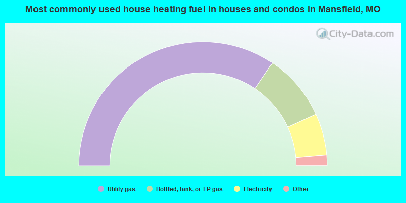
- 69.1%Utility gas
- 17.5%Bottled, tank, or LP gas
- 10.9%Electricity
- 1.4%Wood
- 1.1%Other fuel
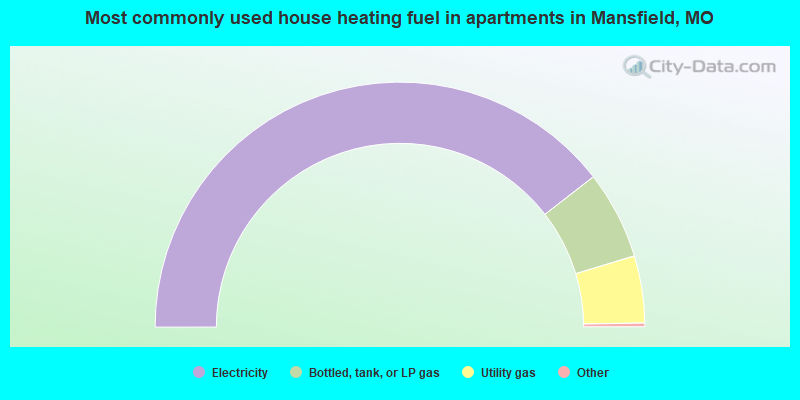
- 79.4%Electricity
- 11.7%Bottled, tank, or LP gas
- 8.9%Utility gas
Mansfield compared to Missouri state average:
- Median household income below state average.
- Median house value below state average.
- Unemployed percentage below state average.
- Black race population percentage significantly below state average.
- Hispanic race population percentage significantly below state average.
- Median age above state average.
- Foreign-born population percentage significantly below state average.
- Renting percentage above state average.
- Length of stay since moving in below state average.
- Number of college students below state average.
- Percentage of population with a bachelor's degree or higher below state average.
Mansfield on our top lists:
- #92 on the list of "Top 101 cities with the most residents born in Belarus (population 500+)"

|
Total of 2 patent applications in 2008-2024.