Marlborough, Connecticut
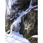
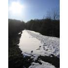
Submit your own pictures of this town and show them to the world
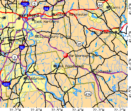
- OSM Map
- General Map
- Google Map
- MSN Map
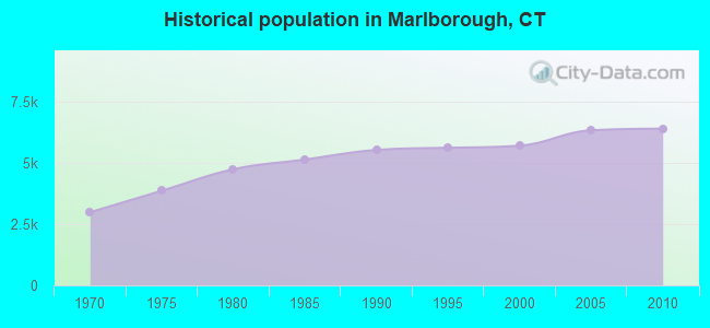
Population change since 2000: +12.2%
 |
| Males: 3,152 | |
| Females: 3,252 |
| Median resident age: | 43.0 years |
| Connecticut median age: | 39.2 years |
Zip codes: 06447.
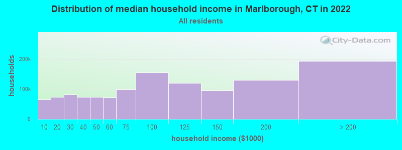
| Marlborough: | $131,598 |
| CT: | $88,429 |
Estimated per capita income in 2022: $63,844 (it was $35,605 in 2000)
Marlborough town income, earnings, and wages data
Estimated median house or condo value in 2022: $386,763 (it was $178,900 in 2000)
| Marlborough: | $386,763 |
| CT: | $347,200 |
Mean prices in 2022: all housing units: $326,390; detached houses: $351,925; townhouses or other attached units: $238,893; in 2-unit structures: $226,606; in 3-to-4-unit structures: $205,937; in 5-or-more-unit structures: $157,099; mobile homes: $128,456
Detailed information about poverty and poor residents in Marlborough, CT


- 5,95292.9%White alone
- 1812.8%Hispanic
- 1031.6%Asian alone
- 841.3%Two or more races
- 711.1%Black alone
- 70.1%American Indian alone
- 40.06%Native Hawaiian and Other
Pacific Islander alone - 20.03%Other race alone
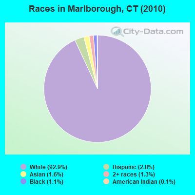
Races in Marlborough detailed stats: ancestries, foreign born residents, place of birth
 Recent articles from our blog. Our writers, many of them Ph.D. graduates or candidates, create easy-to-read articles on a wide variety of topics.

Latest news from Marlborough, CT collected exclusively by city-data.com from local newspapers, TV, and radio stations
Ancestries: Italian (21.2%), Irish (19.3%), English (17.9%), German (11.4%), Polish (10.6%), French (7.8%).
Current Local Time: EST time zone
Incorporated on 10/1803
Elevation: 508 feet
Land area: 23.3 square miles.
Population density: 275 people per square mile (very low).
313 residents are foreign born (3.4% Europe, 0.9% Asia, 0.6% Latin America).
| This town: | 5.5% |
| Connecticut: | 10.9% |
| Marlborough town: | 1.8% ($3,248) |
| Connecticut: | 1.8% ($2,961) |
Nearest city with pop. 50,000+: Manchester, CT  (10.3 miles , pop. 54,740).
Nearest city with pop. 200,000+: Boston, MA (85.0 miles , pop. 589,141).
Nearest city with pop. 1,000,000+: Bronx, NY (91.5 miles , pop. 1,332,650).
Nearest cities:
), ), )Latitude: 41.64 N, Longitude: 72.46 W
Area code commonly used in this area: 860

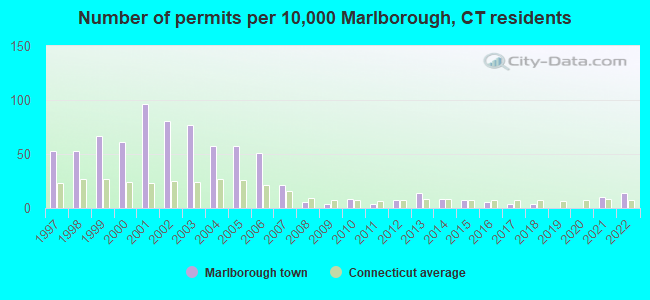
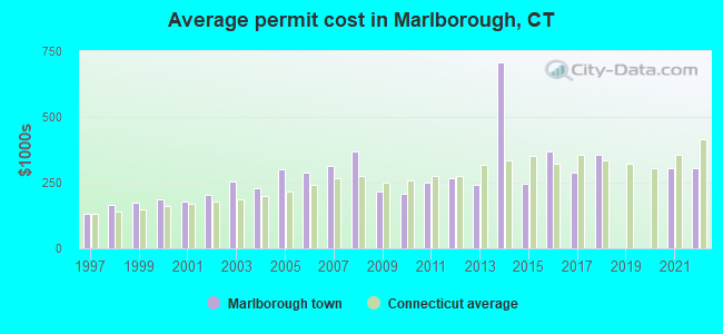
Single-family new house construction building permits:
- 2022: 8 buildings, average cost: $303,000
- 2021: 6 buildings, average cost: $303,000
- 2018: 2 buildings, average cost: $355,000
- 2017: 2 buildings, average cost: $287,500
- 2016: 3 buildings, average cost: $366,700
- 2015: 4 buildings, average cost: $247,300
- 2014: 5 buildings, average cost: $708,000
- 2013: 8 buildings, average cost: $242,900
- 2012: 4 buildings, average cost: $268,700
- 2011: 2 buildings, average cost: $250,100
- 2010: 5 buildings, average cost: $208,700
- 2009: 2 buildings, average cost: $215,000
- 2008: 3 buildings, average cost: $368,600
- 2007: 12 buildings, average cost: $311,700
- 2006: 29 buildings, average cost: $287,100
- 2005: 33 buildings, average cost: $301,700
- 2004: 33 buildings, average cost: $227,900
- 2003: 44 buildings, average cost: $256,400
- 2002: 46 buildings, average cost: $203,700
- 2001: 55 buildings, average cost: $178,300
- 2000: 35 buildings, average cost: $185,400
- 1999: 38 buildings, average cost: $175,300
- 1998: 30 buildings, average cost: $164,200
- 1997: 30 buildings, average cost: $130,700
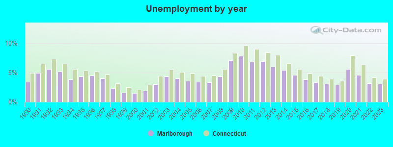
| Here: | 3.1% |
| Connecticut: | 3.9% |
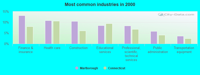
- Finance & insurance (13.2%)
- Health care (10.8%)
- Construction (10.4%)
- Educational services (8.5%)
- Professional, scientific, technical services (8.4%)
- Public administration (5.8%)
- Transportation equipment (3.6%)
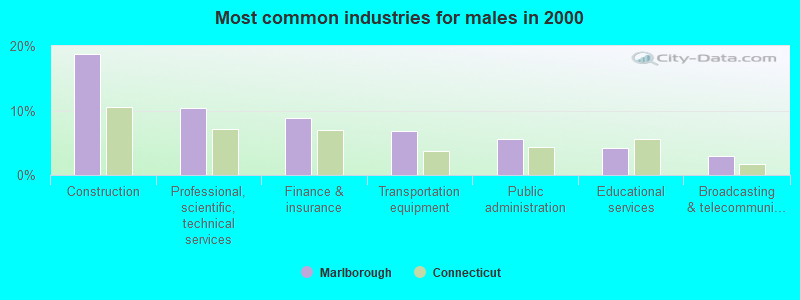
- Construction (18.8%)
- Professional, scientific, technical services (10.3%)
- Finance & insurance (8.9%)
- Transportation equipment (6.9%)
- Public administration (5.6%)
- Educational services (4.2%)
- Broadcasting & telecommunications (2.9%)
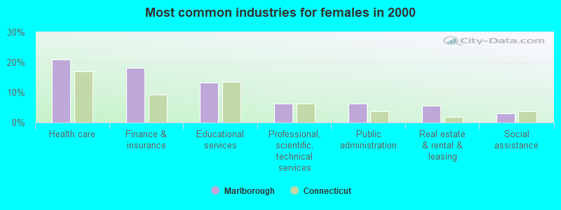
- Health care (20.9%)
- Finance & insurance (18.0%)
- Educational services (13.3%)
- Professional, scientific, technical services (6.2%)
- Public administration (6.2%)
- Real estate & rental & leasing (5.5%)
- Social assistance (3.1%)
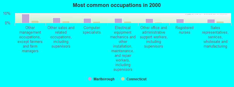
- Other management occupations, except farmers and farm managers (9.4%)
- Other sales and related occupations, including supervisors (5.4%)
- Computer specialists (4.9%)
- Electrical equipment mechanics and other installation, maintenance, and repair workers, including supervisors (4.8%)
- Other office and administrative support workers, including supervisors (4.6%)
- Registered nurses (4.1%)
- Sales representatives, services, wholesale and manufacturing (3.8%)
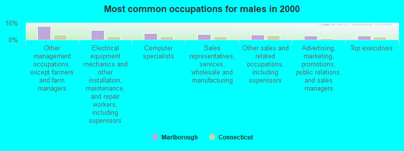
- Other management occupations, except farmers and farm managers (13.0%)
- Electrical equipment mechanics and other installation, maintenance, and repair workers, including supervisors (9.0%)
- Computer specialists (6.3%)
- Sales representatives, services, wholesale and manufacturing (5.3%)
- Other sales and related occupations, including supervisors (4.6%)
- Advertising, marketing, promotions, public relations, and sales managers (4.1%)
- Top executives (3.7%)
- Registered nurses (8.2%)
- Other office and administrative support workers, including supervisors (8.2%)
- Preschool, kindergarten, elementary, and middle school teachers (6.8%)
- Other sales and related occupations, including supervisors (6.2%)
- Other management occupations, except farmers and farm managers (5.3%)
- Secretaries and administrative assistants (4.8%)
- Computer specialists (3.4%)
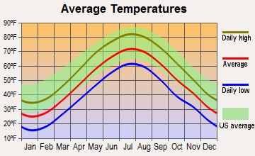
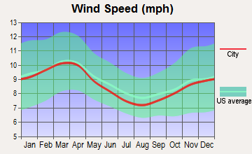
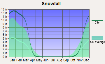
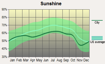
Average climate in Marlborough, Connecticut
Based on data reported by over 4,000 weather stations
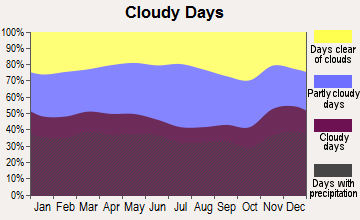
(lower is better)
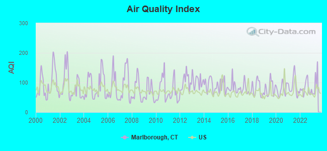
Air Quality Index (AQI) level in 2022 was 80.4. This is about average.
| City: | 80.4 |
| U.S.: | 72.6 |
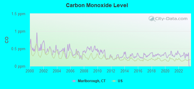
Carbon Monoxide (CO) [ppm] level in 2022 was 0.312. This is worse than average. Closest monitor was 13.4 miles away from the city center.
| City: | 0.312 |
| U.S.: | 0.251 |
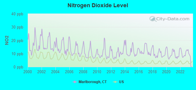
Nitrogen Dioxide (NO2) [ppb] level in 2022 was 10.2. This is significantly worse than average. Closest monitor was 7.0 miles away from the city center.
| City: | 10.2 |
| U.S.: | 5.1 |
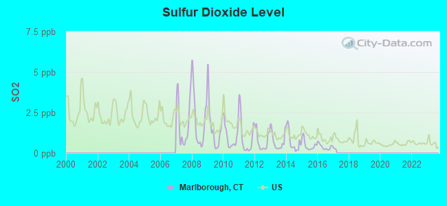
Sulfur Dioxide (SO2) [ppb] level in 2016 was 0.389. This is significantly better than average. Closest monitor was 7.0 miles away from the city center.
| City: | 0.389 |
| U.S.: | 1.515 |
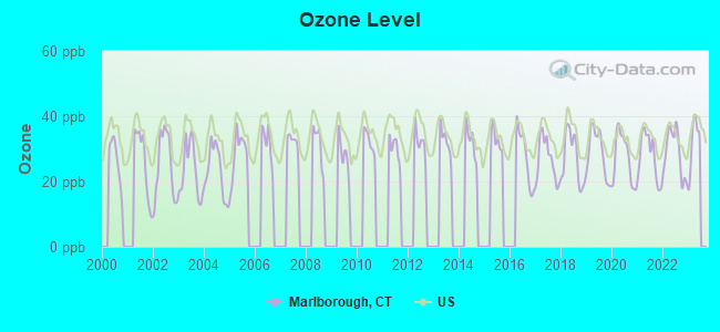
Ozone [ppb] level in 2022 was 28.8. This is about average. Closest monitor was 8.1 miles away from the city center.
| City: | 28.8 |
| U.S.: | 33.3 |
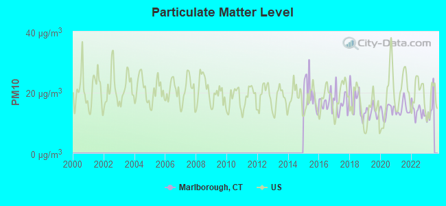
Particulate Matter (PM10) [µg/m3] level in 2022 was 13.8. This is better than average. Closest monitor was 11.4 miles away from the city center.
| City: | 13.8 |
| U.S.: | 19.2 |
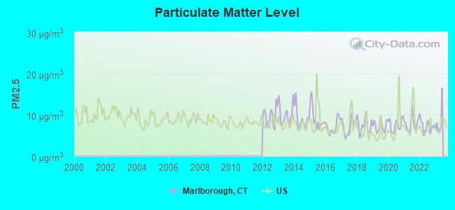
Particulate Matter (PM2.5) [µg/m3] level in 2022 was 7.26. This is about average. Closest monitor was 11.5 miles away from the city center.
| City: | 7.26 |
| U.S.: | 8.11 |
Tornado activity:
Marlborough-area historical tornado activity is near Connecticut state average. It is 28% smaller than the overall U.S. average.
On 10/3/1979, a category F4 (max. wind speeds 207-260 mph) tornado 19.9 miles away from the Marlborough town center killed 3 people and injured 500 people and caused between $50,000,000 and $500,000,000 in damages.
On 7/10/1989, a category F4 tornado 28.8 miles away from the town center injured 40 people and caused between $50,000,000 and $500,000,000 in damages.
Earthquake activity:
Marlborough-area historical earthquake activity is significantly above Connecticut state average. It is 71% smaller than the overall U.S. average.On 10/7/1983 at 10:18:46, a magnitude 5.3 (5.1 MB, 5.3 LG, 5.1 ML, Class: Moderate, Intensity: VI - VII) earthquake occurred 186.4 miles away from Marlborough center
On 4/20/2002 at 10:50:47, a magnitude 5.3 (5.3 ML, Depth: 3.0 mi) earthquake occurred 208.4 miles away from Marlborough center
On 4/20/2002 at 10:50:47, a magnitude 5.2 (5.2 MB, 4.2 MS, 5.2 MW, 5.0 MW) earthquake occurred 207.1 miles away from the city center
On 1/19/1982 at 00:14:42, a magnitude 4.7 (4.5 MB, 4.7 MD, 4.5 LG, Class: Light, Intensity: IV - V) earthquake occurred 136.1 miles away from the city center
On 10/16/2012 at 23:12:25, a magnitude 4.7 (4.7 ML, Depth: 10.0 mi) earthquake occurred 163.8 miles away from Marlborough center
On 8/23/2011 at 17:51:04, a magnitude 5.8 (5.8 MW, Depth: 3.7 mi) earthquake occurred 388.6 miles away from the city center
Magnitude types: regional Lg-wave magnitude (LG), body-wave magnitude (MB), duration magnitude (MD), local magnitude (ML), surface-wave magnitude (MS), moment magnitude (MW)
Natural disasters:
The number of natural disasters in Hartford County (24) is greater than the US average (15).Major Disasters (Presidential) Declared: 13
Emergencies Declared: 11
Causes of natural disasters: Storms: 7, Hurricanes: 5, Floods: 4, Snowstorms: 4, Blizzards: 3, Snows: 3, Tropical Storms: 2, Winter Storms: 2, Snowfall: 1, Tornado: 1, Wind: 1 (Note: some incidents may be assigned to more than one category).
Hospitals and medical centers in Marlborough:
Other hospitals and medical centers near Marlborough:
- STAFF MATES HOMECARE (Home Health Center, about 6 miles away; HEBRON, CT)
- COBALT LODGE HEALTH CARE AND REH (Nursing Home, about 8 miles away; COBALT, CT)
- GLASTONBURY HEALTH CARE CENTER (Nursing Home, about 8 miles away; GLASTONBURY, CT)
- APPLE REHAB COLCHESTER (Nursing Home, about 8 miles away; COLCHESTER, CT)
- HARRINGTON COURT (Nursing Home, about 8 miles away; COLCHESTER, CT)
- AURORA SENIOR LIVING OF CROMWELL, LLC (Nursing Home, about 9 miles away; CROMWELL, CT)
- CROMWELL CREST REST HOME (Nursing Home, about 9 miles away; CROMWELL, CT)
Airports located in Marlborough:
- Salmon River Airfield Airport (9B8) (Runways: 1, Itinerant Ops: 300, Local Ops: 500)
- Rankl Field Airport (CT20) (Runways: 1)
Amtrak stations near Marlborough:
- 15 miles: HARTFORD (1 UNION PLACE) . Services: ticket office, partially wheelchair accessible, enclosed waiting area, public restrooms, public payphones, full-service food facilities, snack bar, vending machines, ATM, paid short-term parking, paid long-term parking, call for car rental service, taxi stand, intercity bus service, public transit connection.
- 16 miles: BERLIN (KENSINGTON, DEPOT RD.) . Services: ticket office, partially wheelchair accessible, enclosed waiting area, public restrooms, public payphones, free short-term parking, free long-term parking, call for car rental service, call for taxi service, public transit connection.
- 18 miles: WINDSOR (41 CENTRAL ST.) . Services: enclosed waiting area, public restrooms, public payphones, free short-term parking, call for car rental service, call for taxi service, public transit connection.
Colleges/universities with over 2000 students nearest to Marlborough:
- Manchester Community College (about 10 miles; Manchester, CT; Full-time enrollment: 4,667)
- Wesleyan University (about 12 miles; Middletown, CT; FT enrollment: 3,517)
- Goodwin College (about 12 miles; East Hartford, CT; FT enrollment: 3,017)
- Eastern Connecticut State University (about 14 miles; Willimantic, CT; FT enrollment: 4,985)
- Trinity College (about 14 miles; Hartford, CT; FT enrollment: 2,355)
- Capital Community College (about 15 miles; Hartford, CT; FT enrollment: 2,609)
- University of Connecticut (about 17 miles; Storrs, CT; FT enrollment: 22,037)
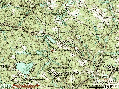
Points of interest:
Notable locations in Marlborough: East Glastonbury Fish and Game Club (A), Hartford County 4-H Camp (B), Marlborough Industrial Park (C), Marlborough Volunteer Fire Department Station 2 (D), Marlborough Volunteer Fire Department Station 1 (E), Richmond Memorial Library (F), Marlborough Town Hall (G), Roy B Pettingill Ambulance Association (H). Display/hide their locations on the map
Shopping Center: Marlborough Commons Shopping Center (1). Display/hide its location on the map
Church in Marlborough: Marlborough Congregational Church (A). Display/hide its location on the map
Cemetery: Old Marlborough Cemetery (1). Display/hide its location on the map
Lakes and swamps: Strong Pond (A), Lake Terramuggus (B), Bear Swamp (C). Display/hide their locations on the map
Streams, rivers, and creeks: Lyman Brook (A), Cattle Lot Brook (B), Fawn Brook (C), Fawn Hill Brook (D), Flat Brook (E), Foot Sawmill Brook (F). Display/hide their locations on the map
Park in Marlborough: Blish Park (1). Display/hide its location on the map
Tourist attraction: Connecticut's Best Restaurants (Tourism Consultants; 185 South Road) (1). Display/hide its approximate location on the map
Birthplace of: Larry Boardman - Boxer, Gretchen Ulion - Ice hockey player.
Drinking water stations with addresses in Marlborough and their reported violations in the past:
MARLBOROUGH HEALTH CARE CENTER, INC (Population served: 165, Groundwater):Past monitoring violations:HILLSIDE CORPORATION (Population served: 136, Groundwater):
- Initial, Follow-up, or Routine Source Water M/R - In JUL-01-1994, Contaminant: Lead and Copper Rule. Follow-up actions: St Violation/Reminder Notice (JUL-18-1994), St Public Notif requested (JUL-18-1994)
Past monitoring violations:LAUREL HILL WATER ASSOCIATION (Population served: 86, Groundwater):
- Initial, Follow-up, or Routine Source Water M/R - In JUL-01-1994, Contaminant: Lead and Copper Rule. Follow-up actions: St Violation/Reminder Notice (JUL-18-1994), St Public Notif requested (JUL-18-1994)
Past health violations:Past monitoring violations:
- MCL, Monthly (TCR) - In SEP-2013, Contaminant: Coliform. Follow-up actions: St Compliance achieved (SEP-30-2013), St Public Notif requested (OCT-10-2013), St Violation/Reminder Notice (OCT-10-2013), St Public Notif received (DEC-31-2013)
- MCL, Monthly (TCR) - Between JUL-2013 and SEP-2013, Contaminant: Coliform. Follow-up actions: St Public Notif received (SEP-08-2013), St Public Notif requested (SEP-12-2013), St Violation/Reminder Notice (SEP-12-2013), St Compliance achieved (SEP-30-2013)
- Follow-up Or Routine LCR Tap M/R - In OCT-01-2003, Contaminant: Lead and Copper Rule. Follow-up actions: St Public Notif received (FEB-14-2004), St BCA signed (MAR-04-2004)
| This town: | 2.8 people |
| Connecticut: | 2.5 people |
| This town: | 79.4% |
| Whole state: | 66.3% |
| This town: | 5.6% |
| Whole state: | 6.6% |
Likely homosexual households (counted as self-reported same-sex unmarried-partner households)
- Lesbian couples: 0.6% of all households
- Gay men: 0.3% of all households
| This town: | 2.2% |
| Whole state: | 7.9% |
| This town: | 1.4% |
| Whole state: | 3.9% |
4 people in group homes intended for adults in 2010
112 people in nursing homes in 2000
Banks with branches in Marlborough (2011 data):
- Bank of America, National Association: Marlborough Branch at Route 66, 17 East Hampton Road, branch established on 1971/02/08. Info updated 2009/11/18: Bank assets: $1,451,969.3 mil, Deposits: $1,077,176.8 mil, headquarters in Charlotte, NC, positive income, 5782 total offices, Holding Company: Bank Of America Corporation
- Liberty Bank: Marlborough Shopping Center Branch at Route 66 And Independence Drive, branch established on 1974/03/29. Info updated 2011/01/06: Bank assets: $3,394.1 mil, Deposits: $2,747.0 mil, headquarters in Middletown, CT, positive income, Commercial Lending Specialization, 43 total offices
For population 15 years and over in Marlborough:
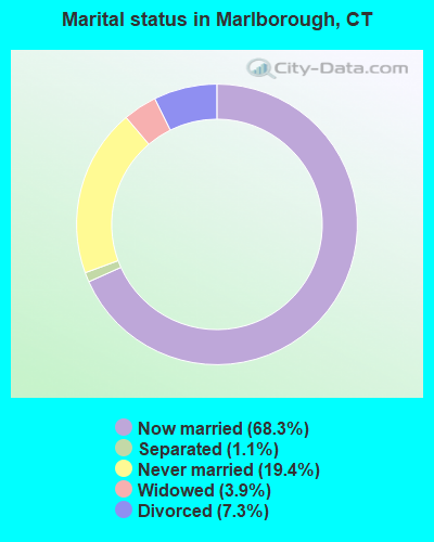
- Never married: 19.4%
- Now married: 68.3%
- Separated: 1.1%
- Widowed: 3.9%
- Divorced: 7.3%
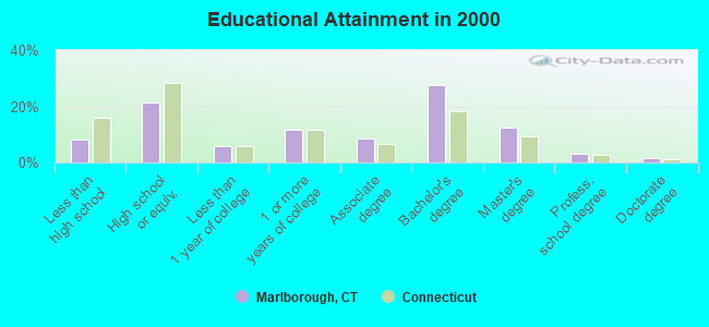
For population 25 years and over in Marlborough:
- High school or higher: 91.9%
- Bachelor's degree or higher: 44.3%
- Graduate or professional degree: 16.9%
- Unemployed: 1.7%
- Mean travel time to work (commute): 28.3 minutes
| Here: | 11.2 |
| Connecticut average: | 12.8 |
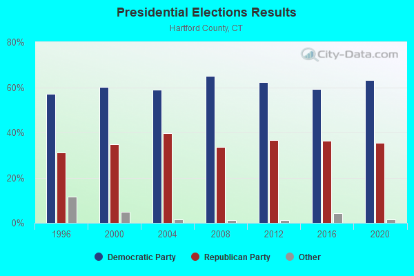
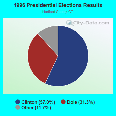
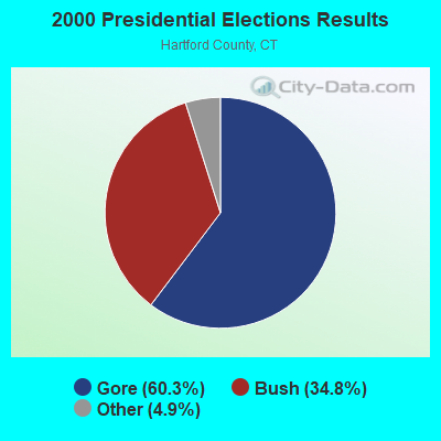
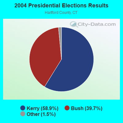
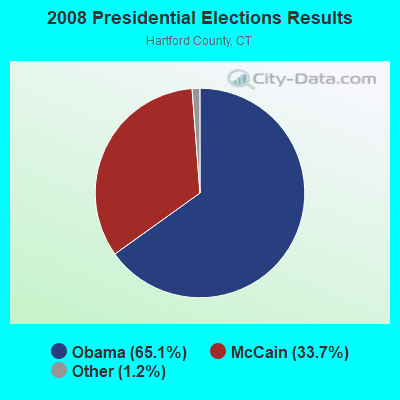
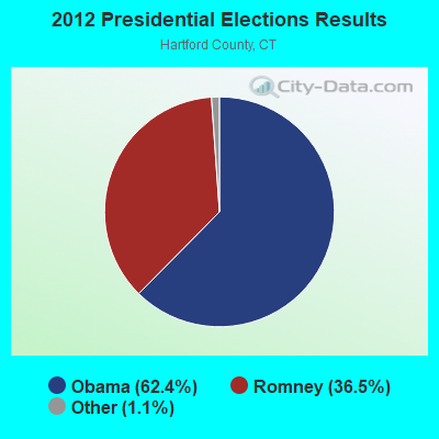
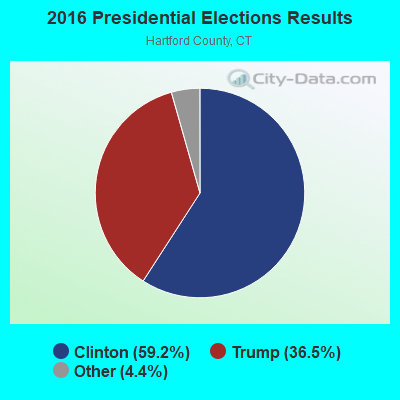
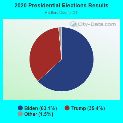
Graphs represent county-level data. Detailed 2008 Election Results
Religion statistics for Marlborough, CT (based on Hartford County data)
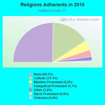
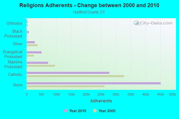
| Religion | Adherents | Congregations |
|---|---|---|
| Catholic | 278,203 | 100 |
| Mainline Protestant | 73,522 | 183 |
| Evangelical Protestant | 50,619 | 214 |
| Other | 28,183 | 94 |
| Black Protestant | 8,446 | 26 |
| Orthodox | 3,665 | 13 |
| None | 451,376 | - |
Food Environment Statistics:
| Hartford County: | 2.46 / 10,000 pop. |
| State: | 2.21 / 10,000 pop. |
| Hartford County: | 0.06 / 10,000 pop. |
| Connecticut: | 0.07 / 10,000 pop. |
| Hartford County: | 1.05 / 10,000 pop. |
| Connecticut: | 1.02 / 10,000 pop. |
| Hartford County: | 2.32 / 10,000 pop. |
| Connecticut: | 2.27 / 10,000 pop. |
| Here: | 8.63 / 10,000 pop. |
| Connecticut: | 9.19 / 10,000 pop. |
| Here: | 7.4% |
| Connecticut: | 7.3% |
| Hartford County: | 22.1% |
| Connecticut: | 21.5% |
| Here: | 16.0% |
| Connecticut: | 15.8% |
4.94% of this county's 2021 resident taxpayers lived in other counties in 2020 ($69,891 average adjusted gross income)
| Here: | 4.94% |
| Connecticut average: | 5.79% |
0.04% of residents moved from foreign countries ($102 average AGI)
Hartford County: 0.04% Connecticut average: 0.02%
Top counties from which taxpayers relocated into this county between 2020 and 2021:
| from New Haven County, CT | |
| from Tolland County, CT | |
| from Middlesex County, CT |
5.15% of this county's 2020 resident taxpayers moved to other counties in 2021 ($92,529 average adjusted gross income)
| Here: | 5.15% |
| Connecticut average: | 5.82% |
0.03% of residents moved to foreign countries ($235 average AGI)
Hartford County: 0.03% Connecticut average: 0.02%
Top counties to which taxpayers relocated from this county between 2020 and 2021:
| to Tolland County, CT | |
| to New Haven County, CT | |
| to Middlesex County, CT |
| Businesses in Marlborough, CT | ||||
| Name | Count | Name | Count | |
|---|---|---|---|---|
| 7-Eleven | 1 | Subway | 1 | |
| Dunkin Donuts | 1 | UPS | 1 | |
Strongest AM radio stations in Marlborough:
- WTIC (1080 AM; 50 kW; HARTFORD, CT; Owner: INFINITY RADIO OPERATIONS INC.)
- WNNZ (640 AM; 50 kW; WESTFIELD, MA; Owner: CLEAR CHANNEL BROADCASTING LICENSES, INC.)
- WCRN (830 AM; 50 kW; WORCESTER, MA; Owner: CARTER BROADCASTING CORPORATION)
- WMRD (1150 AM; 2 kW; MIDDLETOWN, CT; Owner: CROSSROADS COMMUNICATIONS, INC.)
- WALE (990 AM; 50 kW; GREENVILLE, RI; Owner: NORTH AMERICAN BROADCASTING CO., INC.)
- WLAT (910 AM; 5 kW; NEW BRITAIN, CT; Owner: MEGA COMMUNICATIONS OF NEW BRITAIN LICENSEE, LLC)
- WPOP (1410 AM; 5 kW; HARTFORD, CT; Owner: CAPSTAR TX LIMITED PARTNERSHIP)
- WVNE (760 AM; daytime; 25 kW; LEICESTER, MA; Owner: BLOUNT MASSCOM, INC.)
- WDRC (1360 AM; 5 kW; HARTFORD, CT; Owner: BUCKLEY BROADCASTING CORPORATION)
- WEEI (850 AM; 50 kW; BOSTON, MA; Owner: ENTERCOM BOSTON LICENSE, LLC)
- WFAN (660 AM; 50 kW; NEW YORK, NY; Owner: INFINITY BROADCASTING OPERATIONS, INC.)
- WRKO (680 AM; 50 kW; BOSTON, MA; Owner: ENTERCOM BOSTON LICENSE, LLC)
- WICH (1310 AM; 5 kW; NORWICH, CT; Owner: WICH, INCORPORATED)
Strongest FM radio stations in Marlborough:
- WRCH (100.5 FM; NEW BRITAIN, CT; Owner: INFINITY RADIO OPERATIONS INC.)
- WILI-FM (98.3 FM; WILLIMANTIC, CT; Owner: NUTMEG BROADCASTING COMPANY)
- WKSS (95.7 FM; HARTFORD-MERIDEN, CT; Owner: CAPSTAR TX LIMITED PARTNERSHIP)
- WWYZ (92.5 FM; WATERBURY, CT; Owner: CAPSTAR TX LIMITED PARTNERSHIP)
- WZMX (93.7 FM; HARTFORD, CT; Owner: INFINITY RADIO OPERATIONS INC.)
- WHCN (105.9 FM; HARTFORD, CT; Owner: CAPSTAR TX LIMITED PARTNERSHIP)
- WMRQ (104.1 FM; WATERBURY, CT; Owner: CAPSTAR TX LIMITED PARTNERSHIP)
- WTIC-FM (96.5 FM; HARTFORD, CT; Owner: INFINITY RADIO OPERATIONS INC.)
- WPKT (90.5 FM; MERIDEN, CT; Owner: CONNECTICUT PUBLIC BROADCASTING, INC)
- WDRC-FM (102.9 FM; HARTFORD, CT; Owner: BUCKLEY BROADCASTING CORPORATION)
- WWUH (91.3 FM; WEST HARTFORD, CT; Owner: UNIVERSITY OF HARTFORD)
- WCCC-FM (106.9 FM; HARTFORD, CT; Owner: MARLIN BROADCASTING, LLC)
- WECS (90.1 FM; WILLIMANTIC, CT; Owner: EASTERN CONNECTICUT STATE COLLEGE)
- WKCI-FM (101.3 FM; HAMDEN, CT; Owner: CLEAR CHANNEL BROADCASTING LICENSES, INC.)
- WHUS (91.7 FM; STORRS, CT; Owner: THE BD. OF TRUSTEES, THE UNIV. OF CT)
- W227AJ (93.3 FM; NORTHFORD, CT; Owner: SACRED HEART UNIVERSITY)
- WPLR (99.1 FM; NEW HAVEN, CT; Owner: COX RADIO, INC.)
- WIHS (104.9 FM; MIDDLETOWN, CT; Owner: CONNECTICUT RADIO FELLOWSHIP, INC.)
- W258AC (99.5 FM; STORRS, CT; Owner: CONNECTICUT PUBLIC BROADCASTING, INC)
- WAQY (102.1 FM; SPRINGFIELD, MA; Owner: SAGA COMMUNICATIONS OF NEW ENGLAND, LLC)
TV broadcast stations around Marlborough:
- WTIC-TV (Channel 61; HARTFORD, CT; Owner: TRIBUNE TELEVISION COMPANY)
- W11BJ (Channel 11; HARTFORD, CT; Owner: COMMUNICATIONS SITE MANAGEMENT LLC)
- WTXX (Channel 20; WATERBURY, CT; Owner: WTXX INC.)
- WHPX (Channel 26; NEW LONDON, CT; Owner: PAXSON HARTFORD LICENSE, INC.)
- WVIT (Channel 30; NEW BRITAIN, CT; Owner: OUTLET BROADCASTING, INC)
- WUVN (Channel 18; HARTFORD, CT; Owner: ENTRAVISION HOLDINGS, LLC)
- WEDH (Channel 24; HARTFORD, CT; Owner: CONNECTICUT PUBLIC BROADCASTING, INC.)
- WFSB (Channel 3; HARTFORD, CT; Owner: MEREDITH CORPORATION)
- WEDN (Channel 53; NORWICH, CT; Owner: CONNECTICUT PUBLIC BROADCASTING, INC.)
- WHTX-LP (Channel 10; HARTFORD, CT; Owner: ENTRAVISION HOLDINGS, LLC)
- WTNH (Channel 8; NEW HAVEN, CT; Owner: WTNH BROADCASTING, INC.)
- WYDN (Channel 48; WORCESTER, MA; Owner: EDUCATIONAL PUBLIC TV CORPORATION)
- WPXQ (Channel 69; BLOCK ISLAND, RI; Owner: OCEAN STATE TELEVISION, L.L.C.)
- WRDM-LP (Channel 13; HARTFORD, CT; Owner: ZGS HARTFORD, INC.)
- WMLD-LP (Channel 6; HARTFORD, CT; Owner: HARVARD BROADCASTING, INC.)
- WCTX (Channel 59; NEW HAVEN, CT; Owner: WTNH BROADCASTING, INC.)
- WEDY (Channel 65; NEW HAVEN, CT; Owner: CONNECTICUT PUBLIC BROADCASTING, INC.)
- WHCT-LP (Channel 38; HARTFORD, CT; Owner: VENTURE TECHNOLOGIES GROUP, LLC)
- W51BZ (Channel 51; NEW HAVEN, CT; Owner: it COMMUNICATIONS, INC.)
- National Bridge Inventory (NBI) Statistics
- 23Number of bridges
- 190ft / 57.7mTotal length
- $13,695,000Total costs
- 459,139Total average daily traffic
- 42,241Total average daily truck traffic
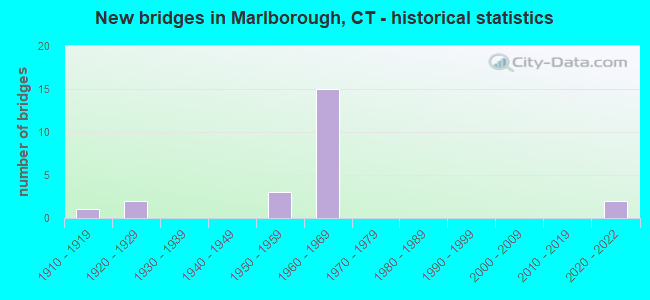
- New bridges - historical statistics
- 11910-1919
- 21920-1929
- 31950-1959
- 151960-1969
- 22020-2022
FCC Registered Cell Phone Towers:
1 (See the full list of FCC Registered Cell Phone Towers in Marlborough)FCC Registered Antenna Towers:
7 (See the full list of FCC Registered Antenna Towers)FCC Registered Broadcast Land Mobile Towers:
3- Town Hall 26 N Main St (Lat: 41.627889 Lon: -72.460639), Call Sign: KNCS301,
Assigned Frequencies: 153.935 MHz, 153.965 MHz, Grant Date: 01/21/2022, Expiration Date: 01/20/2032, Registrant: Town Of Marlborough, 26 North Main Street, Marlborough, CT 06447, Phone: (860) 295-6229, Fax: (860) 295-6230, Email:
- Town Hall N Main St (Lat: 41.627889 Lon: -72.460639), Call Sign: KNGF443,
Assigned Frequencies: 154.025 MHz, Grant Date: 02/06/2023, Expiration Date: 04/07/2033, Registrant: Town Of Marlborough, 26 North Main Street, Marlborough, CT 06447, Phone: (860) 295-6229, Fax: (860) 295-6230, Email:
- Town Hall (Lat: 41.627889 Lon: -72.460639), Call Sign: KXG964, Licensee ID: L00119949,
Assigned Frequencies: 46.5200 MHz, Grant Date: 03/27/2014, Expiration Date: 05/30/2024, Registrant: Marlborough, Town Of, Marlborough, CT 06447, Phone: (860) 295-6204
FCC Registered Microwave Towers:
1- Lat: 41.511750 Lon: -72.552861, Call Sign: WPNL594,
Assigned Frequencies: 952.418 MHz, Grant Date: 04/07/1998, Expiration Date: 04/07/2008, Cancellation Date: 06/07/2008, Registrant: Amr Data Corporation, 9 Riverside Road, Weston, MA 02193
FCC Registered Amateur Radio Licenses:
52 (See the full list of FCC Registered Amateur Radio Licenses in Marlborough)FAA Registered Aircraft Manufacturers and Dealers:
2 (See the full list of FAA Registered Manufacturers and Dealers in Marlborough)FAA Registered Aircraft:
12 (See the full list of FAA Registered Aircraft)2002 - 2018 National Fire Incident Reporting System (NFIRS) incidents
- Fire incident types reported to NFIRS in Marlborough, CT
- 10144.3%Structure Fires
- 6829.8%Outside Fires
- 4921.5%Mobile Property/Vehicle Fires
- 104.4%Other
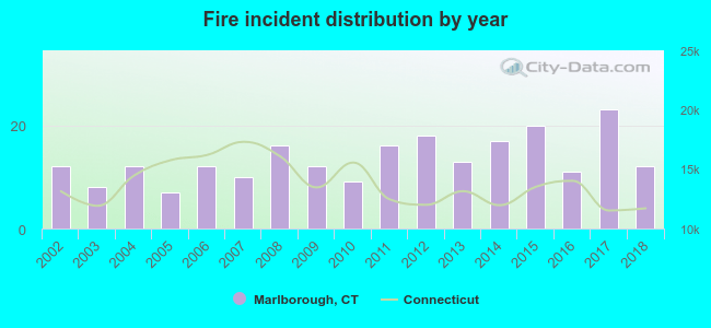 According to the data from the years 2002 - 2018 the average number of fire incidents per year is 13. The highest number of fire incidents - 23 took place in 2017, and the least - 7 in 2005. The data has a constant trend.
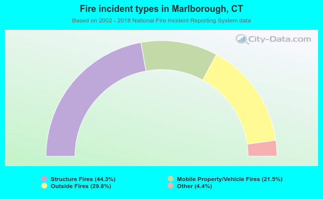 When looking into fire subcategories, the most incidents belonged to: Structure Fires (44.3%), and Outside Fires (29.8%).
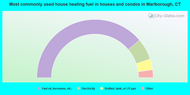
- 77.7%Fuel oil, kerosene, etc.
- 11.9%Electricity
- 6.1%Bottled, tank, or LP gas
- 3.0%Wood
- 0.9%Utility gas
- 0.3%Coal or coke
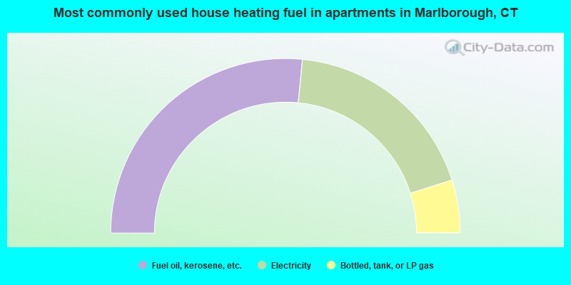
- 53.1%Fuel oil, kerosene, etc.
- 37.1%Electricity
- 9.8%Bottled, tank, or LP gas
Marlborough compared to Connecticut state average:
- Unemployed percentage significantly below state average.
- Black race population percentage significantly below state average.
- Hispanic race population percentage significantly below state average.
- Foreign-born population percentage significantly below state average.
- Renting percentage significantly below state average.
- Length of stay since moving in significantly above state average.
- Number of rooms per house significantly below state average.
- House age significantly below state average.
- Percentage of population with a bachelor's degree or higher above state average.
Marlborough on our top lists:
- #3 on the list of "Top 101 cities with largest percentage of females in occupations: business operations specialists (population 5,000+)"
- #10 on the list of "Top 101 cities with largest percentage of males in occupations: cashiers (population 5,000+)"
- #23 on the list of "Top 101 cities with largest percentage of females in occupations: registered nurses (population 5,000+)"
- #23 on the list of "Top 101 cities with largest percentage of females in industries: drugs, sundries, and chemical and allied products merchant wholesalers (population 5,000+)"
- #24 on the list of "Top 101 cities with largest percentage of males in occupations: advertising, marketing, promotions, public relations, and sales managers (population 5,000+)"
- #24 on the list of "Top 101 cities with largest percentage of males in industries: alcoholic beverages merchant wholesalers (population 5,000+)"
- #31 on the list of "Top 101 cities with largest percentage of males in occupations: pipelayers, plumbers, pipefitters, and steamfitters (population 5,000+)"
- #35 on the list of "Top 101 cities with largest percentage of males in occupations: electrical equipment mechanics and other installation, maintenance, and repair occupations including supervisors (population 5,000+)"
- #41 on the list of "Top 101 cities with largest percentage of females in industries: finance and insurance (population 5,000+)"
- #53 on the list of "Top 101 cities with largest percentage of males in industries: beverage and tobacco products (population 5,000+)"
- #57 on the list of "Top 101 cities with largest percentage of females in industries: music stores (population 5,000+)"
- #62 on the list of "Top 101 cities with largest percentage of males in industries: farm supplies merchant wholesalers (population 5,000+)"
- #89 on the list of "Top 101 cities with largest percentage of males in industries: paper and paper products merchant wholesalers (population 5,000+)"
- #92 on the list of "Top 101 cities with largest percentage of males in industries: petroleum and petroleum products merchant wholesalers (population 5,000+)"
- #96 on the list of "Top 101 cities with largest percentage of males in industries: other direct selling establishments (population 5,000+)"
- #99 on the list of "Top 101 cities with largest percentage of females in industries: professional and commercial equipment and supplies merchant wholesalers (population 5,000+)"
- #2 on the list of "Top 101 counties with highest percentage of residents voting for Obama (Democrat) in the 2012 Presidential Election"
- #17 on the list of "Top 101 counties with the most Catholic congregations"
- #19 on the list of "Top 101 counties with the lowest Particulate Matter (PM10) Annual air pollution readings in 2012 (µg/m3)"
- #24 on the list of "Top 101 counties with the highest percentage of residents that visited a dentist within the past year"
- #29 on the list of "Top 101 counties with the most Mainline Protestant congregations"

|
|
Total of 293 patent applications in 2008-2024.