Mayetta, Kansas
Submit your own pictures of this city and show them to the world
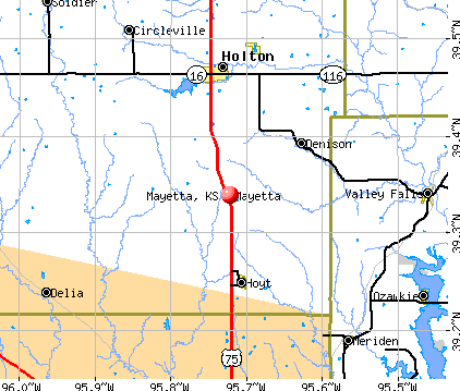
- OSM Map
- General Map
- Google Map
- MSN Map
Population change since 2000: +13.5%
 |
| Males: 168 | |
| Females: 186 |
| Median resident age: | 28.3 years |
| Kansas median age: | 37.6 years |
Zip codes: 66509.
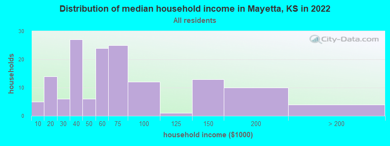
| Mayetta: | $54,352 |
| KS: | $68,925 |
Estimated per capita income in 2022: $32,169 (it was $14,800 in 2000)
Mayetta city income, earnings, and wages data
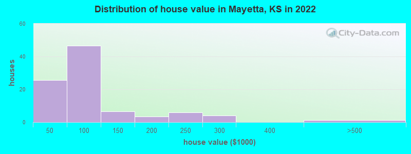
Estimated median house or condo value in 2022: $87,748 (it was $50,000 in 2000)
| Mayetta: | $87,748 |
| KS: | $206,600 |
Mean prices in 2022: all housing units: $99,703; detached houses: $110,833; mobile homes: $37,697
Median gross rent in 2022: $1,130.
(6.2% for White Non-Hispanic residents, 100.0% for Black residents, 14.3% for Hispanic or Latino residents, 41.7% for American Indian residents, 1.9% for two or more races residents)
Detailed information about poverty and poor residents in Mayetta, KS
Compare current foreclosures near Mayetta, KS:
| Photo | Address | Area | Beds / Baths | Price | Details |
|---|---|---|---|---|---|

|
#1
E Clark St
Mayetta, KS 66509
|
- sq. feet
|
- baths - beds |
show details | |

|
#2
S Rd
Mayetta, KS 66509
|
- sq. feet
|
- baths - beds |
show details | |

|
#3
Vermont Ave
Holton, KS 66436
|
1,796 sq. feet
|
2 baths 3 beds |
$37,900
|
show details |

|
#4
NW Topeka Blvd
Topeka, KS 66617
|
1,608 sq. feet
|
1 baths 4 beds |
$49,900
|
show details |

|
#5
NW Green Hills Rd
Topeka, KS 66618
|
1,262 sq. feet
|
1 baths 3 beds |
show details | |

|
#6
NW Sioux Ln
Topeka, KS 66618
|
1,572 sq. feet
|
2 baths 4 beds |
show details | |

|
#7
NW Pottawatomie Rd
Topeka, KS 66618
|
1,728 sq. feet
|
1 baths 3 beds |
show details | |

|
#8
NE Edgewood Dr
Topeka, KS 66617
|
1,388 sq. feet
|
2 baths 3 beds |
show details | |

|
#9
NE Edgewood Dr
Topeka, KS 66617
|
1,739 sq. feet
|
3 baths 4 beds |
show details | |

|
#10
NW Rochester Rd
Topeka, KS 66617
|
1,627 sq. feet
|
2 baths 3 beds |
show details |
| Photo | Address | Area | Beds / Baths | Price | Details |
|---|---|---|---|---|---|

|
#11
NW Geronimo Trl
Topeka, KS 66618
|
1,443 sq. feet
|
2 baths 3 beds |
show details | |

|
#12
NW 44th St
Topeka, KS 66618
|
1,854 sq. feet
|
2 baths 3 beds |
show details | |

|
#13
Delaware Dr
Ozawkie, KS 66070
|
2,160 sq. feet
|
2 baths 3 beds |
show details | |

|
#14
Jesse James Rd
Ozawkie, KS 66070
|
1,350 sq. feet
|
1 baths 3 beds |
show details | |

|
#15
NW Melba Dr
Topeka, KS 66618
|
1,690 sq. feet
|
2 baths 3 beds |
show details | |

|
#16
Delaware Dr
Ozawkie, KS 66070
|
1,136 sq. feet
|
1 baths 3 beds |
show details | |

|
#17
NW 35th St
Topeka, KS 66618
|
1,880 sq. feet
|
2 baths 3 beds |
show details | |

|
#18
NW 35th St
Topeka, KS 66618
|
2,750 sq. feet
|
3 baths 4 beds |
show details | |

|
#19
NW Rochester Rd
Topeka, KS 66617
|
1,370 sq. feet
|
1 baths 3 beds |
show details | |

|
#20
NE 39th St
Topeka, KS 66617
|
1,598 sq. feet
|
1 baths 2 beds |
show details |
| Photo | Address | Area | Beds / Baths | Price | Details |
|---|---|---|---|---|---|

|
#21
NW Hodges Rd
Silver Lake, KS 66539
|
3,443 sq. feet
|
3 baths 5 beds |
show details | |

|
#22
NW Huxman Rd
Silver Lake, KS 66539
|
1,288 sq. feet
|
2 baths 3 beds |
show details | |

|
#23
Walnut St
Valley Falls, KS 66088
|
920 sq. feet
|
1 baths 2 beds |
show details | |

|
#24
NW 58th St
Topeka, KS 66617
|
816 sq. feet
|
1 baths 2 beds |
show details | |

|
#25
Prairie Bend Rd
Meriden, KS 66512
|
1,479 sq. feet
|
2 baths 3 beds |
show details | |

|
#26
123rd Ln
Hoyt, KS 66440
|
1,288 sq. feet
|
2 baths 3 beds |
show details | |

|
#27
Mckeage Ave
Hoyt, KS 66440
|
2,292 sq. feet
|
2 baths 4 beds |
show details | |

|
#28
102nd Rd
Hoyt, KS 66440
|
1,654 sq. feet
|
2 baths 4 beds |
show details | |

|
#29
102nd Rd
Hoyt, KS 66440
|
852 sq. feet
|
1 baths 2 beds |
show details | |

|
#30
M Rd
Holton, KS 66436
|
1,364 sq. feet
|
1 baths 2 beds |
show details |
| Photo | Address | Area | Beds / Baths | Price | Details |
|---|---|---|---|---|---|

|
#31
W4 Rd
Holton, KS 66436
|
1,741 sq. feet
|
1 baths 2 beds |
show details | |

|
#32
Pennsylvania Ave
Holton, KS 66436
|
1,344 sq. feet
|
1 baths 3 beds |
show details | |

|
#33
Washington Ave
Holton, KS 66436
|
960 sq. feet
|
2 baths 3 beds |
show details | |

|
#34
Colorado Ave
Holton, KS 66436
|
2,277 sq. feet
|
1 baths 3 beds |
show details | |

|
#35
NW 25th St
Topeka, KS 66618
|
1,476 sq. feet
|
1 baths 3 beds |
show details | |

|
#36
NE 59th Ter
Topeka, KS 66617
|
1,365 sq. feet
|
2 baths 3 beds |
show details | |

|
#37
NW Rochester Rd
Topeka, KS 66617
|
1,253 sq. feet
|
1 baths 3 beds |
show details | |

|
#38
NW Green Hills Rd
Topeka, KS 66618
|
2,172 sq. feet
|
3 baths 5 beds |
show details | |

|
#39
NW 49th Ter
Topeka, KS 66618
|
- sq. feet
|
- baths - beds |
show details | |

|
#40
NW 49th St
Topeka, KS 66618
|
- sq. feet
|
- baths - beds |
show details |
| Photo | Address | Area | Beds / Baths | Price | Details |
|---|---|---|---|---|---|

|
#41
Oak St
Valley Falls, KS 66088
|
- sq. feet
|
- baths - beds |
show details | |

|
#42
NW Redbud Cir Apt 1
Topeka, KS 66617
|
- sq. feet
|
- baths - beds |
show details | |

|
#43
12th St
Valley Falls, KS 66088
|
- sq. feet
|
- baths - beds |
show details | |

|
#44
NE Meriden Rd
Topeka, KS 66617
|
- sq. feet
|
- baths - beds |
show details | |

|
#45
Highland Ave
Hoyt, KS 66440
|
- sq. feet
|
- baths - beds |
show details | |

|
#46
NW Fielding Pl Apt 7
Topeka, KS 66618
|
- sq. feet
|
- baths - beds |
show details | |

|
#47
New Jersey Ave
Holton, KS 66436
|
- sq. feet
|
- baths - beds |
show details | |

|
#48
NW 33rd St
Topeka, KS 66618
|
- sq. feet
|
- baths - beds |
show details | |

|
#49
NW Rochester Rd
Topeka, KS 66617
|
- sq. feet
|
- baths - beds |
show details | |

|
Check over 1 million property listings on Foreclosure.com!
|
browse all offers | |||


- 28365.5%White alone
- 11326.2%Two or more races
- 306.9%American Indian alone
- 143.2%Hispanic
- 30.7%Black alone
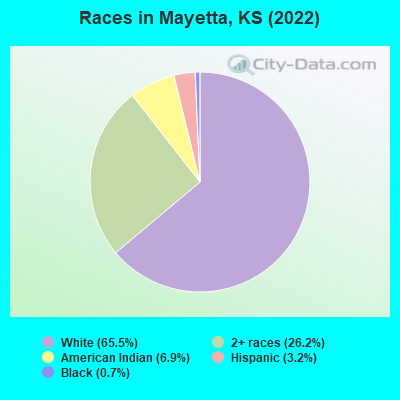
Races in Mayetta detailed stats: ancestries, foreign born residents, place of birth
According to our research of Kansas and other state lists, there were 7 registered sex offenders living in Mayetta, Kansas as of May 10, 2024.
The ratio of all residents to sex offenders in Mayetta is 47 to 1.
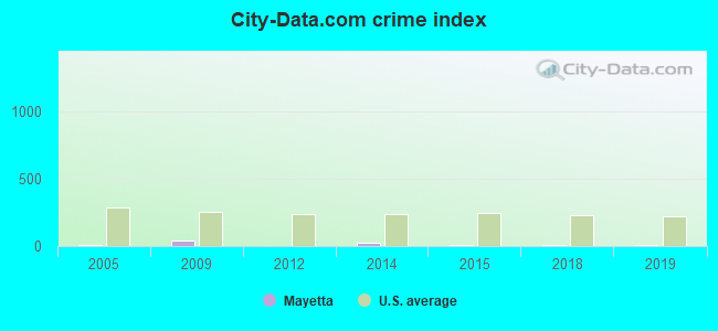
Type |
2009 |
2012 |
2014 |
2015 |
2018 |
2019 |
|---|---|---|---|---|---|---|
| Murders (per 100,000) | 0 (0.0) | 0 (0.0) | 0 (0.0) | 0 (0.0) | 0 (0.0) | 0 (0.0) |
| Rapes (per 100,000) | 0 (0.0) | 0 (0.0) | 0 (0.0) | 0 (0.0) | 0 (0.0) | 0 (0.0) |
| Robberies (per 100,000) | 0 (0.0) | 0 (0.0) | 0 (0.0) | 0 (0.0) | 0 (0.0) | 0 (0.0) |
| Assaults (per 100,000) | 0 (0.0) | 0 (0.0) | 0 (0.0) | 0 (0.0) | 0 (0.0) | 0 (0.0) |
| Burglaries (per 100,000) | 2 (561.8) | 0 (0.0) | 1 (304.9) | 0 (0.0) | 0 (0.0) | 0 (0.0) |
| Thefts (per 100,000) | 0 (0.0) | 0 (0.0) | 0 (0.0) | 1 (292.4) | 1 (285.7) | 1 (286.5) |
| Auto thefts (per 100,000) | 0 (0.0) | 0 (0.0) | 0 (0.0) | 0 (0.0) | 0 (0.0) | 0 (0.0) |
| Arson (per 100,000) | 0 (0.0) | 0 (0.0) | 0 (0.0) | 0 (0.0) | 0 (0.0) | 0 (0.0) |
| City-Data.com crime index | 39.3 | 0.0 | 21.3 | 11.7 | 11.4 | 11.5 |
The City-Data.com crime index weighs serious crimes and violent crimes more heavily. Higher means more crime, U.S. average is 246.1. It adjusts for the number of visitors and daily workers commuting into cities.
Crime rate in Mayetta detailed stats: murders, rapes, robberies, assaults, burglaries, thefts, arson
 Recent articles from our blog. Our writers, many of them Ph.D. graduates or candidates, create easy-to-read articles on a wide variety of topics.

 | Montara in Topeka (18 replies) |
| Small Towns That Don't Want To Be Big? (12 replies) |
Latest news from Mayetta, KS collected exclusively by city-data.com from local newspapers, TV, and radio stations
Ancestries: American (13.0%), German (9.5%), Irish (5.5%), European (1.5%).
Current Local Time: CST time zone
Elevation: 1200 feet
Land area: 0.17 square miles.
Population density: 2,143 people per square mile (low).
1 resident is foreign born
| This city: | 0.3% |
| Kansas: | 5.0% |
Median real estate property taxes paid for housing units with mortgages in 2022: $1,171 (1.3%)
Median real estate property taxes paid for housing units with no mortgage in 2022: $937 (1.3%)
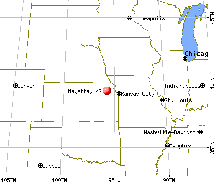
Nearest city with pop. 50,000+: Topeka, KS  (20.8 miles , pop. 122,377).
Nearest city with pop. 200,000+: Kansas City, MO (65.1 miles , pop. 441,545).
Nearest city with pop. 1,000,000+: Dallas, TX (456.2 miles , pop. 1,188,580).
Nearest cities:
), ), ), )Latitude: 39.34 N, Longitude: 95.72 W
Area code: 785

Mayetta tourist attractions:
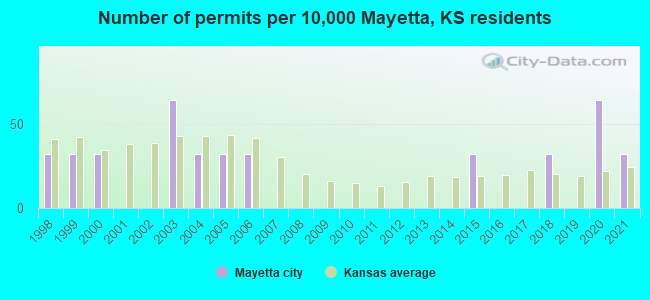
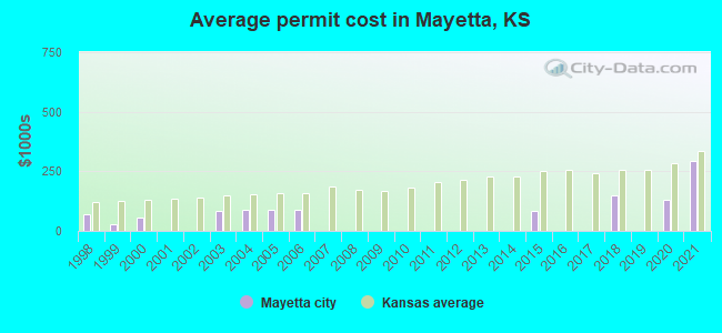
Single-family new house construction building permits:
- 2021: 1 building, cost: $296,000
- 2020: 2 buildings, average cost: $130,000
- 2018: 1 building, cost: $150,000
- 2015: 1 building, cost: $85,000
- 2006: 1 building, cost: $90,000
- 2005: 1 building, cost: $90,000
- 2004: 1 building, cost: $90,000
- 2003: 2 buildings, average cost: $85,000
- 2000: 1 building, cost: $57,700
- 1999: 1 building, cost: $27,500
- 1998: 1 building, cost: $70,000
| Here: | 1.9% |
| Kansas: | 2.0% |
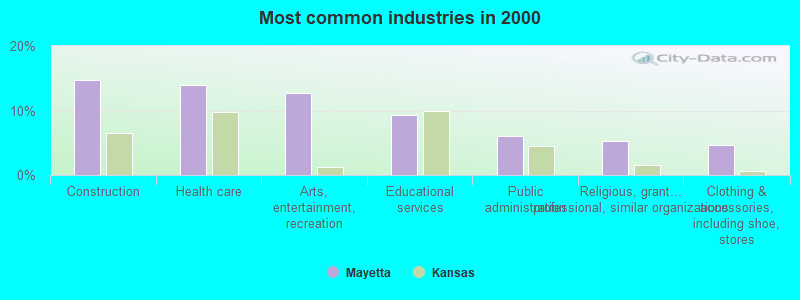
- Construction (14.7%)
- Health care (14.0%)
- Arts, entertainment, recreation (12.7%)
- Educational services (9.3%)
- Public administration (6.0%)
- Religious, grantmaking, civic, professional, similar organizations (5.3%)
- Clothing & accessories, including shoe, stores (4.7%)
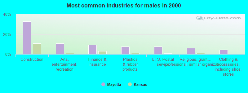
- Construction (32.8%)
- Arts, entertainment, recreation (10.9%)
- Finance & insurance (9.4%)
- Plastics & rubber products (7.8%)
- U. S. Postal service (7.8%)
- Religious, grantmaking, civic, professional, similar organizations (6.2%)
- Clothing & accessories, including shoe, stores (4.7%)
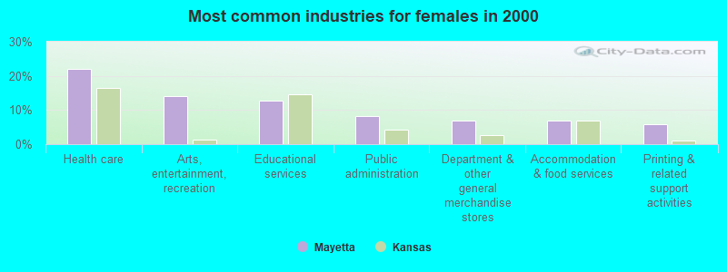
- Health care (22.1%)
- Arts, entertainment, recreation (14.0%)
- Educational services (12.8%)
- Public administration (8.1%)
- Department & other general merchandise stores (7.0%)
- Accommodation & food services (7.0%)
- Printing & related support activities (5.8%)
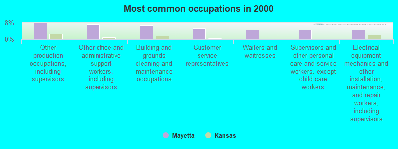
- Other production occupations, including supervisors (8.0%)
- Other office and administrative support workers, including supervisors (7.3%)
- Building and grounds cleaning and maintenance occupations (6.7%)
- Customer service representatives (5.3%)
- Waiters and waitresses (4.7%)
- Supervisors and other personal care and service workers, except child care workers (4.7%)
- Electrical equipment mechanics and other installation, maintenance, and repair workers, including supervisors (4.7%)
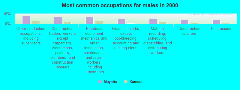
- Other production occupations, including supervisors (12.5%)
- Construction traders workers except carpenters, electricians, painters, plumbers, and construction laborers (10.9%)
- Electrical equipment mechanics and other installation, maintenance, and repair workers, including supervisors (10.9%)
- Financial clerks, except bookkeeping, accounting and auditing clerks (7.8%)
- Material recording, scheduling, dispatching, and distributing workers (7.8%)
- Construction laborers (6.2%)
- Electricians (6.2%)
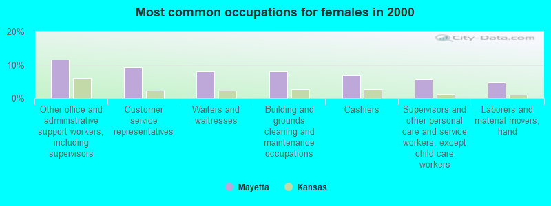
- Other office and administrative support workers, including supervisors (11.6%)
- Customer service representatives (9.3%)
- Waiters and waitresses (8.1%)
- Building and grounds cleaning and maintenance occupations (8.1%)
- Cashiers (7.0%)
- Supervisors and other personal care and service workers, except child care workers (5.8%)
- Laborers and material movers, hand (4.7%)
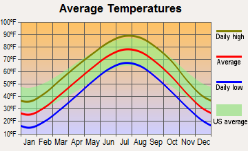
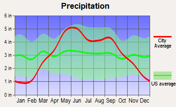
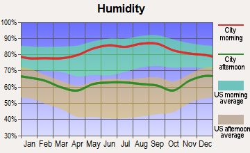
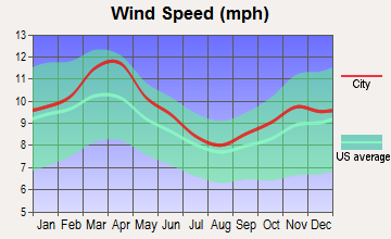
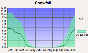
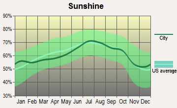
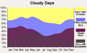
Average climate in Mayetta, Kansas
Based on data reported by over 4,000 weather stations
(lower is better)
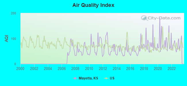
Air Quality Index (AQI) level in 2022 was 67.9. This is about average.
| City: | 67.9 |
| U.S.: | 72.6 |
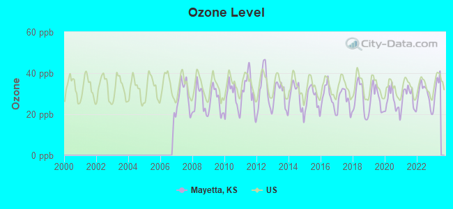
Ozone [ppb] level in 2022 was 29.6. This is about average. Closest monitor was 20.1 miles away from the city center.
| City: | 29.6 |
| U.S.: | 33.3 |
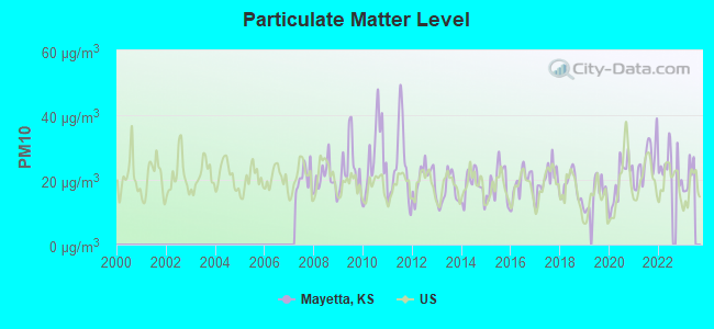
Particulate Matter (PM10) [µg/m3] level in 2022 was 24.7. This is worse than average. Closest monitor was 20.7 miles away from the city center.
| City: | 24.7 |
| U.S.: | 19.2 |
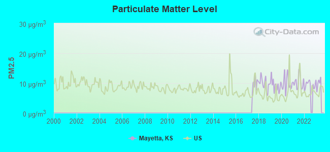
Particulate Matter (PM2.5) [µg/m3] level in 2022 was 9.39. This is about average. Closest monitor was 20.7 miles away from the city center.
| City: | 9.39 |
| U.S.: | 8.11 |
Tornado activity:
Mayetta-area historical tornado activity is near Kansas state average. It is 103% greater than the overall U.S. average.
On 6/8/1966, a category F5 (max. wind speeds 261-318 mph) tornado 19.4 miles away from the Mayetta city center killed 16 people and injured 450 people and caused between $50,000,000 and $500,000,000 in damages.
On 8/6/1962, a category F4 (max. wind speeds 207-260 mph) tornado 4.0 miles away from the city center injured 3 people and caused between $50,000 and $500,000 in damages.
Earthquake activity:
Mayetta-area historical earthquake activity is significantly above Kansas state average. It is 531% greater than the overall U.S. average.On 9/3/2016 at 12:02:44, a magnitude 5.8 (5.8 MW, Depth: 3.5 mi, Class: Moderate, Intensity: VI - VII) earthquake occurred 212.0 miles away from the city center
On 11/6/2011 at 03:53:10, a magnitude 5.7 (5.7 MW, Depth: 3.2 mi) earthquake occurred 269.5 miles away from the city center
On 11/12/2014 at 21:40:00, a magnitude 4.9 (4.9 MW, Depth: 2.5 mi, Class: Light, Intensity: IV - V) earthquake occurred 176.3 miles away from Mayetta center
On 2/13/2016 at 17:07:06, a magnitude 5.1 (5.1 MW, Depth: 5.2 mi) earthquake occurred 255.7 miles away from the city center
On 11/7/2016 at 01:44:24, a magnitude 5.0 (5.0 MW, Depth: 2.8 mi) earthquake occurred 239.0 miles away from the city center
On 1/19/2020 at 19:08:42, a magnitude 4.5 (4.5 MW, Depth: 3.1 mi) earthquake occurred 151.8 miles away from the city center
Magnitude types: moment magnitude (MW)
Natural disasters:
The number of natural disasters in Jackson County (17) is near the US average (15).Major Disasters (Presidential) Declared: 14
Emergencies Declared: 2
Causes of natural disasters: Floods: 12, Storms: 11, Tornadoes: 7, Winter Storms: 4, Heavy Rain: 1, Hurricane: 1, Snowstorm: 1, Wind: 1, Other: 1 (Note: some incidents may be assigned to more than one category).

Hospitals and medical centers near Mayetta:
- MEDICALODGES HOLTON (Nursing Home, about 9 miles away; HOLTON, KS)
- MEDICALODGES JACKSON COUNTY (Nursing Home, about 10 miles away; HOLTON, KS)
- PENNSYLVANIA PLACE (Hospital, about 10 miles away; HOLTON, KS)
- HOLTON COMMUNITY HOSPITAL HHA (Home Health Center, about 10 miles away; HOLTON, KS)
- VALLEY HEALTH CARE CENTER (Nursing Home, about 15 miles away; VALLEY FALLS, KS)
Colleges/universities with over 2000 students nearest to Mayetta:
- Washburn University (about 22 miles; Topeka, KS; Full-time enrollment: 5,092)
- University of Kansas (about 37 miles; Lawrence, KS; FT enrollment: 22,788)
- Highland Community College (about 44 miles; Highland, KS; FT enrollment: 2,148)
- Kansas State University (about 48 miles; Manhattan, KS; FT enrollment: 20,703)
- Baker University (about 49 miles; Baldwin City, KS; FT enrollment: 2,752)
- Kansas City Kansas Community College (about 55 miles; Kansas City, KS; FT enrollment: 4,718)
- Park University (about 57 miles; Parkville, MO; FT enrollment: 9,131)
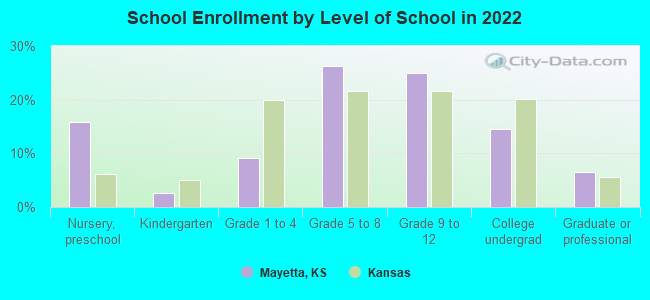
Public elementary/middle school in Mayetta:
- ROYAL VALLEY MIDDLE SCHOOL (Students: 275, Location: 204 S 4TH, Grades: 5-8)
Points of interest:
Notable locations in Mayetta: Mayetta Police Department (A), Mayetta Rural Fire District 1 (B). Display/hide their locations on the map
Churches in Mayetta include: Mayetta Christian Church (A), Saint Francis Xavier Church (B). Display/hide their locations on the map
Hotel: Harrah's Prairie Band (12305 150th Road).
| This city: | 2.7 people |
| Kansas: | 2.5 people |
| This city: | 68.0% |
| Whole state: | 66.0% |
| This city: | 8.8% |
| Whole state: | 5.8% |
Likely homosexual households (counted as self-reported same-sex unmarried-partner households)
- Lesbian couples: 0.0% of all households
- Gay men: 0.8% of all households
For population 15 years and over in Mayetta:
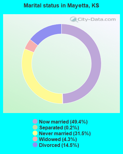
- Never married: 31.5%
- Now married: 49.4%
- Separated: 0.2%
- Widowed: 4.3%
- Divorced: 14.5%
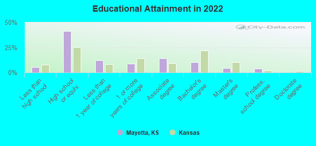
For population 25 years and over in Mayetta:
- High school or higher: 93.6%
- Bachelor's degree or higher: 17.8%
- Graduate or professional degree: 8.1%
- Unemployed: 2.6%
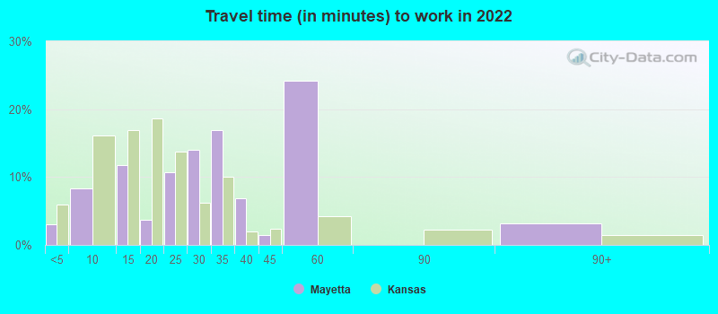
- Mean travel time to work (commute): 17.0 minutes
| Here: | 9.7 |
| Kansas average: | 11.5 |
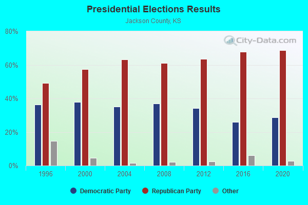
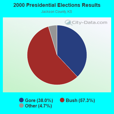
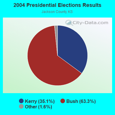
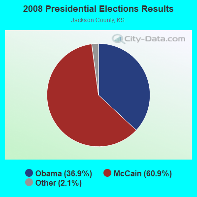
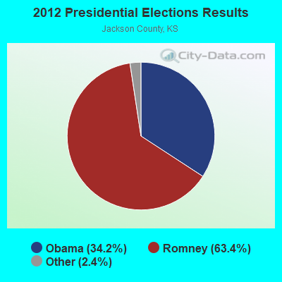
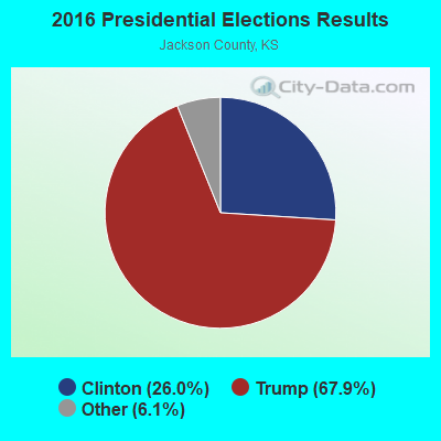
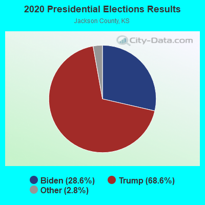
Graphs represent county-level data. Detailed 2008 Election Results
Religion statistics for Mayetta, KS (based on Jackson County data)
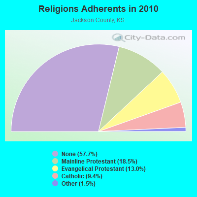
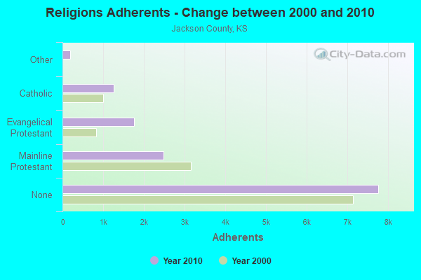
| Religion | Adherents | Congregations |
|---|---|---|
| Mainline Protestant | 2,487 | 17 |
| Evangelical Protestant | 1,753 | 11 |
| Catholic | 1,261 | 2 |
| Other | 198 | 3 |
| None | 7,763 | - |
Food Environment Statistics:
| Jackson County: | 3.75 / 10,000 pop. |
| State: | 1.96 / 10,000 pop. |
| This county: | 0.75 / 10,000 pop. |
| Kansas: | 3.84 / 10,000 pop. |
| Jackson County: | 6.74 / 10,000 pop. |
| Kansas: | 7.33 / 10,000 pop. |
| Jackson County: | 9.1% |
| Kansas: | 8.1% |
| Here: | 28.1% |
| Kansas: | 27.9% |
| Jackson County: | 14.9% |
| State: | 13.4% |
Health and Nutrition:
| Mayetta: | 49.0% |
| Kansas: | 49.2% |
| Mayetta: | 47.2% |
| Kansas: | 46.3% |
| This city: | 29.3 |
| Kansas: | 28.6 |
| This city: | 18.6% |
| Kansas: | 21.2% |
| This city: | 9.4% |
| Kansas: | 10.5% |
| This city: | 6.8 |
| Kansas: | 6.8 |
| Mayetta: | 34.6% |
| State: | 33.5% |
| This city: | 57.5% |
| State: | 56.0% |
| Here: | 80.0% |
| Kansas: | 78.6% |
More about Health and Nutrition of Mayetta, KS Residents
| Local government employment and payroll (March 2022) | |||||
| Function | Full-time employees | Monthly full-time payroll | Average yearly full-time wage | Part-time employees | Monthly part-time payroll |
|---|---|---|---|---|---|
| Other Government Administration | 1 | $4,070 | $48,840 | 7 | $788 |
| Police Protection - Officers | 0 | $0 | 1 | $883 | |
| Water Supply | 0 | $0 | 2 | $675 | |
| Totals for Government | 1 | $4,070 | $48,840 | 10 | $2,346 |
Mayetta government finances - Expenditure in 2017 (per resident):
- Current Operations - Water Utilities: $93,000 ($262.71)
Police Protection: $77,000 ($217.51)
Central Staff Services: $66,000 ($186.44)
Sewerage: $24,000 ($67.80)
Solid Waste Management: $22,000 ($62.15)
Regular Highways: $18,000 ($50.85)
- General - Interest on Debt: $11,000 ($31.07)
- Total Salaries and Wages: $46,000 ($129.94)
Mayetta government finances - Revenue in 2017 (per resident):
- Charges - Sewerage: $39,000 ($110.17)
Solid Waste Management: $21,000 ($59.32)
- Local Intergovernmental - General Local Government Support: $30,000 ($84.75)
- Miscellaneous - Interest Earnings: $10,000 ($28.25)
General Revenue - Other: $6,000 ($16.95)
Special Assessments: $2,000 ($5.65)
Rents: $1,000 ($2.82)
Donations From Private Sources: $1,000 ($2.82)
- Revenue - Water Utilities: $105,000 ($296.61)
- State Intergovernmental - Highways: $9,000 ($25.42)
- Tax - Property: $68,000 ($192.09)
Public Utilities Sales: $12,000 ($33.90)
Other License: $1,000 ($2.82)
Mayetta government finances - Debt in 2017 (per resident):
- Long Term Debt - Beginning Outstanding - Unspecified Public Purpose: $190,000 ($536.72)
Outstanding Unspecified Public Purpose: $159,000 ($449.15)
Retired Unspecified Public Purpose: $31,000 ($87.57)
Mayetta government finances - Cash and Securities in 2017 (per resident):
- Other Funds - Cash and Securities: $473,000 ($1336.16)
- Sinking Funds - Cash and Securities: $22,000 ($62.15)
Strongest AM radio stations in Mayetta:
- WIBW (580 AM; 5 kW; TOPEKA, KS; Owner: MCC RADIO, LLC)
- WHB (810 AM; 50 kW; KANSAS CITY, MO; Owner: UNION BROADCASTING, INC.)
- KMAJ (1440 AM; 5 kW; TOPEKA, KS; Owner: CUMULUS LICENSING CORP.)
- KKHK (1250 AM; 25 kW; KANSAS CITY, KS)
- KOIL (1020 AM; 50 kW; PLATTSMOUTH, NE; Owner: WAITT RADIO, INC.)
- KCMO (710 AM; 10 kW; KANSAS CITY, MO; Owner: SUSQUEHANNA KANSAS CITY PARTNERSHIP)
- KFAB (1110 AM; 50 kW; OMAHA, NE; Owner: CAPSTAR TX LIMITED PARTNERSHIP)
- KKAR (1290 AM; 50 kW; OMAHA, NE; Owner: WAITT RADIO, INC.)
- KTOP (1490 AM; 1 kW; TOPEKA, KS; Owner: CUMULUS LICENSING CORP.)
- KFEQ (680 AM; 5 kW; ST. JOSEPH, MO; Owner: EAGLE RADIO, INC.)
- KCSP (610 AM; 5 kW; KANSAS CITY, MO; Owner: ENTERCOM KANSAS CITY LICENSE, LLC)
- KKLO (1410 AM; 5 kW; LEAVENWORTH, KS; Owner: CHARA COMMUNICATIONS, INC.)
- KCCV (760 AM; daytime; 6 kW; OVERLAND PARK, KS; Owner: BOTT BROADCASTING COMPANY)
Strongest FM radio stations in Mayetta:
- KJTY (88.1 FM; TOPEKA, KS; Owner: JOY PUBLIC BROADCASTING CORPORATION)
- WIBW-FM (94.5 FM; TOPEKA, KS; Owner: MCC RADIO, LLC)
- KMAJ-FM (107.7 FM; TOPEKA, KS; Owner: CUMULUS LICENSING CORP.)
- KTPK (106.9 FM; TOPEKA, KS; Owner: KANSAS CAPITAL BROADCASTING, INC.)
- KQTP (102.9 FM; ST. MARYS, KS; Owner: CUMULUS LICENSING CORP.)
- KDVV (100.3 FM; TOPEKA, KS; Owner: CUMULUS LICENSING CORP.)
- KLZR (105.9 FM; LAWRENCE, KS; Owner: ZIMMER RADIO OF MID-MISSOURI, INC)
- KWIC (99.3 FM; TOPEKA, KS; Owner: CUMULUS LICENSING CORP.)
- KNZA (103.9 FM; HIAWATHA, KS; Owner: KNZA, INC.)
- KBUZ (90.3 FM; TOPEKA, KS; Owner: AMERICAN FAMILY ASSOCIATION, INC.)
- KCHZ (95.7 FM; OTTAWA, KS; Owner: SYNCOM RADIO CORPORATION)
- KCVT (92.5 FM; SILVER LAKE, KS; Owner: RICHARD P. BOTT, II)
- KANU (91.5 FM; LAWRENCE, KS; Owner: UNIVERSITY OF KANSAS)
- K205CS (88.9 FM; TOPEKA, KS; Owner: CALVARY CHAPEL OF TWIN FALLS, INC.)
TV broadcast stations around Mayetta:
- KSNT (Channel 27; TOPEKA, KS; Owner: EMMIS TELEVISION LICENSE CORPORATION OF TOPEKA)
- KTWU (Channel 11; TOPEKA, KS; Owner: WASHBURN UNIVERSITY OF TOPEKA)
- KTKA-TV (Channel 49; TOPEKA, KS; Owner: NORTHEAST KANSAS BROADCAST SERVICE, INC.)
- WIBW-TV (Channel 13; TOPEKA, KS; Owner: GRAY MIDAMERICA TV LICENSEE CORP.)
- KTMJ-CA (Channel 43; TOPEKA, KS; Owner: MONTGOMERY COMMUNICATIONS, INC.)
- K21AP (Channel 55; TOPEKA, KS; Owner: TRINITY BROADCASTING NETWORK)
Mayetta fatal accident list:
- National Bridge Inventory (NBI) Statistics
- 23Number of bridges
- 171ft / 51.7mTotal length
- 18,225Total average daily traffic
- 2,750Total average daily truck traffic
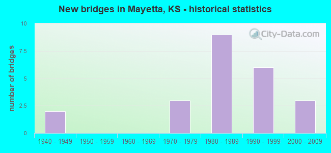
- New bridges - historical statistics
- 21940-1949
- 31970-1979
- 91980-1989
- 61990-1999
- 32000-2009
FCC Registered Cell Phone Towers:
1 (See the full list of FCC Registered Cell Phone Towers in Mayetta)FCC Registered Antenna Towers:
23 (See the full list of FCC Registered Antenna Towers)FCC Registered Broadcast Land Mobile Towers:
6- Bps- Us 75 & 182nd Rd (Lat: 39.376000 Lon: -95.738500), Type: Upole, Structure height: 6.1 m, Call Sign: WPKI420,
Assigned Frequencies: 456.050 MHz, Grant Date: 02/16/2002, Expiration Date: 02/28/2012, Cancellation Date: 05/05/2012, Certifier: Edward S Dunn, Registrant: Micro Comm Inc, 15895 S Pflumm Rd., Olathe, KS 66062, Phone: (913) 390-4500, Fax: (913) 390-4550, Email:
- Lat: 39.034722 Lon: -95.814972, Call Sign: WPUU735,
Assigned Frequencies: 173.362 MHz, 173.362 MHz, Grant Date: 05/06/2022, Expiration Date: 05/07/2032, Certifier: Dave Price, Registrant: Tbs Electronics, Inc., 5225 Sw Topeka Blvd, Topeka, KS 66609, Phone: (785) 862-7450, Email:
- Lat: 39.317778 Lon: -94.755833, Call Sign: WQAB839,
Assigned Frequencies: 152.405 MHz, Grant Date: 04/30/2004, Expiration Date: 04/30/2014, Cancellation Date: 07/05/2014, Certifier: Frank M Kopp, Registrant: Dougs Electronics, 213 West Fourth St., Holton, KS 66436, Phone: (785) 364-2016, Fax: (785) 364-2108
- Lat: 39.319667 Lon: -95.738333, Call Sign: WQKX579,
Assigned Frequencies: 452.412 MHz, 457.412 MHz, 467.237 MHz, 467.437 MHz, Grant Date: 10/19/2009, Expiration Date: 10/19/2019, Cancellation Date: 12/21/2019, Certifier: Liana Onnen, Registrant: Cara Enterprises Inc, Salt Lake City, UT 84117-0503, Phone: (801) 278-9728, Fax: (801) 278-7239, Email:
- BPS, Us 75 & 182nd Rd (Lat: 39.376000 Lon: -95.738500), Type: Upole, Structure height: 6.1 m, Call Sign: WQYJ362,
Assigned Frequencies: 456.050 MHz, Grant Date: 10/17/2016, Expiration Date: 10/17/2026, Certifier: Brenda Adkins, Registrant: Micro-Comm, ,Inc, 15895 S Pflumm, Olathe, KS 66062, Phone: (913) 390-4500, Email:
- Lat: 39.304167 Lon: -95.700917, Call Sign: WRJF464,
Assigned Frequencies: 451.762 MHz, 452.162 MHz, 452.762 MHz, 456.762 MHz, 457.162 MHz, Grant Date: 08/20/2020, Expiration Date: 08/20/2030, Certifier: Aaric S Davis, Registrant: Tfmcomm Inc, 125 Sw Jackson, Topeka, KS 66603, Phone: (785) 233-2343, Email:
FCC Registered Microwave Towers:
12 (See the full list of FCC Registered Microwave Towers in this town)FCC Registered Amateur Radio Licenses:
8 (See the full list of FCC Registered Amateur Radio Licenses in Mayetta)FAA Registered Aircraft:
2- Aircraft: BAUER FRED JR/BEC INC THORP T-18 (Category: Land, Seats: 2, Weight: Up to 12,499 Pounds), Engine: LYCOMING IO-320 SERIES (150 HP) (Reciprocating)
N-Number: 89SB, N89SB, N-89SB, Serial Number: 1337, Year manufactured: 1981, Airworthiness Date: 07/31/1981, Certificate Issue Date: 08/08/2008
Registrant (Individual): Patrick R Hicks, 16274 150th Rd, Mayetta, KS 66509 - Aircraft: PIPER PA-28-140 (Category: Land, Seats: 4, Weight: Up to 12,499 Pounds, Speed: 107 mph), Engine: LYCOMING 0-320 SERIES (180 HP) (Reciprocating)
N-Number: 98308, N98308, N-98308, Serial Number: 28-26162, Year manufactured: 1969, Airworthiness Date: 07/18/1969, Certificate Issue Date: 11/16/2018
Registrant (Co-Owned): Robert M Morse, 14838 150th Rd, Mayetta, KS 66509, Other Owners: Alma J Morse
2002 - 2018 National Fire Incident Reporting System (NFIRS) incidents
- Fire incident types reported to NFIRS in Mayetta, KS
- 1,28971.1%Outside Fires
- 29216.1%Structure Fires
- 1669.2%Mobile Property/Vehicle Fires
- 673.7%Other
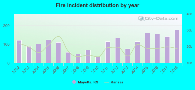 According to the data from the years 2002 - 2018 the average number of fires per year is 107. The highest number of fires - 175 took place in 2018, and the least - 32 in 2010. The data has a growing trend.
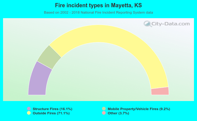 When looking into fire subcategories, the most reports belonged to: Outside Fires (71.1%), and Structure Fires (16.1%).
| Most common first names in Mayetta, KS among deceased individuals | ||
| Name | Count | Lived (average) |
|---|---|---|
| James | 18 | 76.5 years |
| John | 15 | 75.3 years |
| William | 13 | 81.3 years |
| Mary | 12 | 78.4 years |
| Charles | 11 | 81.3 years |
| George | 10 | 75.0 years |
| Robert | 9 | 66.6 years |
| Frank | 7 | 80.1 years |
| Clarence | 5 | 74.4 years |
| Elizabeth | 5 | 79.6 years |
| Most common last names in Mayetta, KS among deceased individuals | ||
| Last name | Count | Lived (average) |
|---|---|---|
| Johnson | 9 | 69.3 years |
| Whittington | 6 | 87.0 years |
| Kern | 5 | 84.0 years |
| Masquat | 5 | 74.4 years |
| Mccrory | 5 | 88.2 years |
| Wamego | 5 | 71.8 years |
| Buehler | 4 | 82.5 years |
| Fitzgerald | 4 | 84.0 years |
| Hale | 4 | 82.5 years |
| Clark | 4 | 70.3 years |
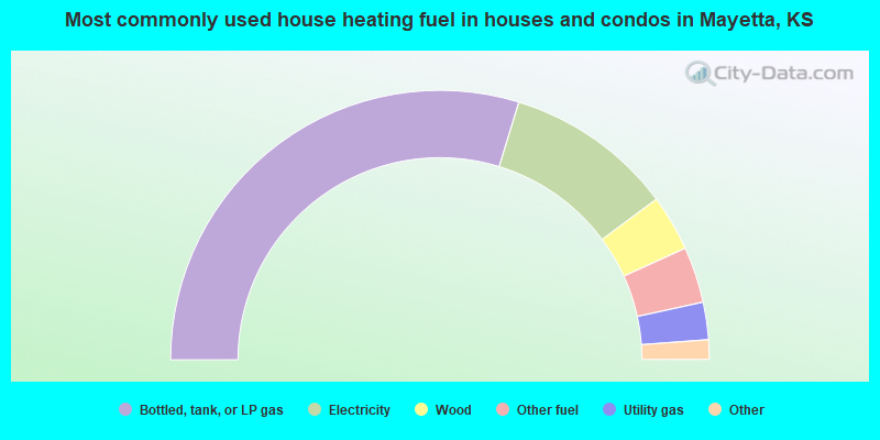
- 60.9%Bottled, tank, or LP gas
- 20.7%Electricity
- 6.9%Wood
- 6.9%Other fuel
- 4.6%Utility gas
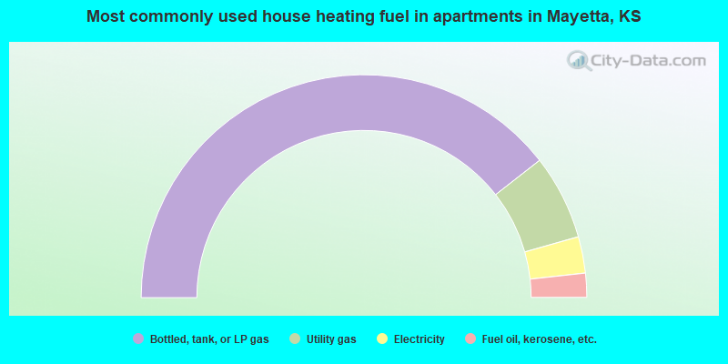
- 78.9%Bottled, tank, or LP gas
- 12.3%Utility gas
- 5.3%Electricity
- 3.5%Fuel oil, kerosene, etc.
Mayetta compared to Kansas state average:
- Median house value significantly below state average.
- Unemployed percentage significantly below state average.
- Black race population percentage significantly below state average.
- Hispanic race population percentage significantly below state average.
- Foreign-born population percentage significantly below state average.
- Length of stay since moving in significantly above state average.
- House age above state average.