Maysville, Kentucky

Maysville: the old bridge in maysville taken at 6:30 am with fog on river
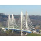
Maysville: new bridge in maysville 2003
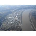
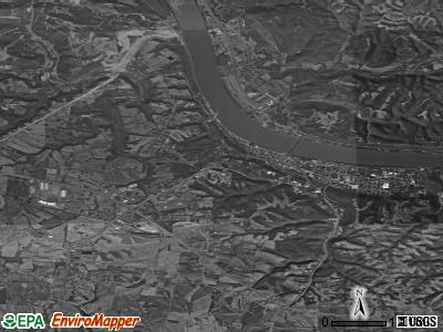
Maysville: Maysville from the air.
Maysville: Maysville View from Ohio
Maysville: Maysville Bridge
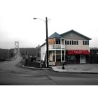
Maysville: The bridge
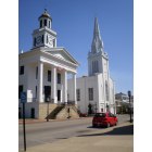
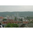
Maysville: Downtown Maysville

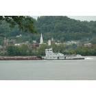
Maysville: Downtown Maysville the riverside

Maysville: Handprints in Clay decorate the Tunnel to the River Pier in Maysville
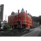
Maysville: Cloudy day
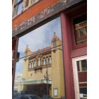
Maysville: Reflection of the Russell Theater in Maysville, Currently Undergoing Restoration
- see
16
more - add
your
Submit your own pictures of this city and show them to the world
- OSM Map
- General Map
- Google Map
- MSN Map
Population change since 2000: -2.8%
 |
| Males: 4,186 | |
| Females: 4,556 |
| Median resident age: | 41.8 years |
| Kentucky median age: | 39.4 years |
Zip codes: 41056.
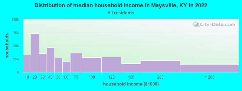
| Maysville: | $40,595 |
| KY: | $59,341 |
Estimated per capita income in 2022: $31,520 (it was $16,836 in 2000)
Maysville city income, earnings, and wages data
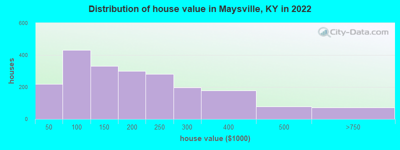
Estimated median house or condo value in 2022: $162,474 (it was $73,200 in 2000)
| Maysville: | $162,474 |
| KY: | $196,300 |
Mean prices in 2022: all housing units: $233,057; detached houses: $238,174; townhouses or other attached units: $160,788; in 2-unit structures: $126,760; in 5-or-more-unit structures: $249,138; mobile homes: $15,949
Median gross rent in 2022: $681.
(22.1% for White Non-Hispanic residents, 24.4% for Black residents, 38.6% for Hispanic or Latino residents, 100.0% for American Indian residents, 33.5% for two or more races residents)
Detailed information about poverty and poor residents in Maysville, KY

Compare current foreclosures in Maysville, KY:
| Photo | Address | Area | Beds / Baths | Price | Details |
|---|---|---|---|---|---|

|
#1
Classic Dr
Maysville, KY 41056
|
950 sq. feet
|
1 baths 3 beds |
show details | |

|
#2
Hinton Dr
Maysville, KY 41056
|
1,640 sq. feet
|
2 baths 3 beds |
show details | |

|
#3
Mason Lewis Rd
Maysville, KY 41056
|
1,426 sq. feet
|
1 baths 3 beds |
show details | |

|
#4
Mason Lewis Rd
Maysville, KY 41056
|
1,500 sq. feet
|
2 baths 4 beds |
show details | |

|
#5
Cedarwood Dr
Maysville, KY 41056
|
1,377 sq. feet
|
2 baths 3 beds |
show details | |

|
#6
Lexington Pike
Maysville, KY 41056
|
2,388 sq. feet
|
2 baths 4 beds |
show details | |

|
#7
Mason Lewis Rd
Maysville, KY 41056
|
1,848 sq. feet
|
1 baths 3 beds |
show details | |

|
#8
Old Main St
Maysville, KY 41056
|
1,564 sq. feet
|
1 baths 3 beds |
show details | |

|
#9
Broadway St
Maysville, KY 41056
|
1,470 sq. feet
|
1 baths 3 beds |
show details | |

|
#10
Bridge St
Maysville, KY 41056
|
1,870 sq. feet
|
1 baths 3 beds |
show details |
| Photo | Address | Area | Beds / Baths | Price | Details |
|---|---|---|---|---|---|

|
#11
Stonelick Rd
Maysville, KY 41056
|
1,812 sq. feet
|
1 baths 3 beds |
show details | |

|
#12
Walnut Ln
Maysville, KY 41056
|
2,016 sq. feet
|
2 baths 4 beds |
show details | |

|
#13
Jersey Ridge Rd
Maysville, KY 41056
|
10,000 sq. feet
|
1 baths 2 beds |
show details | |

|
#14
Highland Dr
Maysville, KY 41056
|
1,124 sq. feet
|
1 baths 3 beds |
show details | |

|
#15
Orangeburg Rd
Maysville, KY 41056
|
1,328 sq. feet
|
2 baths 2 beds |
show details | |

|
#16
Florence St
Maysville, KY 41056
|
870 sq. feet
|
1 baths 2 beds |
show details | |

|
#17
Joyce Ann Cir
Maysville, KY 41056
|
1,128 sq. feet
|
1 baths 3 beds |
show details | |

|
#18
Ash St
Maysville, KY 41056
|
1,320 sq. feet
|
1 baths 2 beds |
show details | |

|
#19
Us Highway 62
Maysville, KY 41056
|
1,794 sq. feet
|
2 baths 3 beds |
show details | |

|
#20
Murphysville Rd
Maysville, KY 41056
|
913 sq. feet
|
1 baths 2 beds |
show details |
| Photo | Address | Area | Beds / Baths | Price | Details |
|---|---|---|---|---|---|

|
#21
Ash St
Maysville, KY 41056
|
832 sq. feet
|
1 baths 2 beds |
show details | |

|
#22
Hinton Dr
Maysville, KY 41056
|
1,456 sq. feet
|
1 baths 3 beds |
show details | |

|
#23
Commerce St
Maysville, KY 41056
|
1,040 sq. feet
|
1 baths 2 beds |
show details | |

|
#24
Canebrake Dr
Maysville, KY 41056
|
1,050 sq. feet
|
1 baths 3 beds |
show details | |

|
#25
Orangeburg Rd
Maysville, KY 41056
|
1,456 sq. feet
|
- baths - beds |
show details | |

|
#26
Key Pike
Maysville, KY 41056
|
- sq. feet
|
- baths - beds |
show details | |

|
#27
Orangeburg Rd
Maysville, KY 41056
|
- sq. feet
|
- baths - beds |
show details | |

|
#28
Buckingham Sq
Maysville, KY 41056
|
- sq. feet
|
- baths - beds |
show details | |

|
#29
Polecat Pike
Maysville, KY 41056
|
- sq. feet
|
- baths - beds |
show details | |

|
#30
Lake Charles Dr
Maysville, KY 41056
|
- sq. feet
|
- baths - beds |
show details |
| Photo | Address | Area | Beds / Baths | Price | Details |
|---|---|---|---|---|---|

|
#31
W Maple Leaf Rd
Maysville, KY 41056
|
- sq. feet
|
- baths - beds |
show details | |

|
#32
Pickett Ln
Maysville, KY 41056
|
- sq. feet
|
- baths - beds |
show details | |

|
#33
E 2nd St
Maysville, KY 41056
|
- sq. feet
|
- baths - beds |
show details | |

|
#34
Houston Ave
Maysville, KY 41056
|
- sq. feet
|
- baths - beds |
show details | |

|
#35
Norma Everman Dr
Maysville, KY 41056
|
- sq. feet
|
- baths - beds |
show details | |

|
#36
Murphysville Rd
Maysville, KY 41056
|
2,240 sq. feet
|
- baths - beds |
show details | |

|
#37
W Maple Leaf Rd
Maysville, KY 41056
|
- sq. feet
|
- baths - beds |
show details | |

|
Check over 1 million property listings on Foreclosure.com!
|
browse all offers | |||


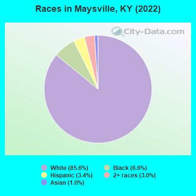
- 7,57485.6%White alone
- 5866.6%Black alone
- 3013.4%Hispanic
- 2663.0%Two or more races
- 861.0%Asian alone
Races in Maysville detailed stats: ancestries, foreign born residents, place of birth
According to our research of Kentucky and other state lists, there were 34 registered sex offenders living in Maysville, Kentucky as of April 27, 2024.
The ratio of all residents to sex offenders in Maysville is 263 to 1.
Type |
2009 |
2010 |
2011 |
2012 |
2013 |
2014 |
2015 |
2016 |
2017 |
2018 |
2019 |
2020 |
2021 |
2022 |
|---|---|---|---|---|---|---|---|---|---|---|---|---|---|---|
| Murders (per 100,000) | 0 (0.0) | 0 (0.0) | 0 (0.0) | 0 (0.0) | 0 (0.0) | 0 (0.0) | 0 (0.0) | 0 (0.0) | 0 (0.0) | 0 (0.0) | 0 (0.0) | 0 (0.0) | 1 (11.6) | 0 (0.0) |
| Rapes (per 100,000) | 4 (43.1) | 6 (66.6) | 5 (55.1) | 3 (32.9) | 4 (44.3) | 8 (89.9) | 6 (68.1) | 4 (45.6) | 7 (79.2) | 6 (68.4) | 6 (68.6) | 4 (46.0) | 6 (69.4) | 6 (69.2) |
| Robberies (per 100,000) | 6 (64.7) | 6 (66.6) | 9 (99.2) | 5 (54.8) | 6 (66.5) | 3 (33.7) | 10 (113.5) | 9 (102.5) | 2 (22.6) | 6 (68.4) | 6 (68.6) | 8 (92.0) | 6 (69.4) | 1 (11.5) |
| Assaults (per 100,000) | 5 (53.9) | 5 (55.5) | 7 (77.2) | 8 (87.7) | 4 (44.3) | 7 (78.7) | 2 (22.7) | 6 (68.3) | 13 (147.0) | 9 (102.6) | 7 (80.0) | 14 (161.0) | 7 (80.9) | 3 (34.6) |
| Burglaries (per 100,000) | 144 (1,552) | 188 (2,086) | 102 (1,124) | 72 (789.7) | 87 (964.1) | 68 (764.5) | 54 (613.0) | 53 (603.6) | 57 (644.7) | 47 (535.9) | 37 (422.9) | 59 (678.6) | 72 (832.4) | 25 (288.3) |
| Thefts (per 100,000) | 330 (3,557) | 342 (3,795) | 337 (3,714) | 327 (3,587) | 291 (3,225) | 267 (3,002) | 225 (2,554) | 243 (2,768) | 258 (2,918) | 214 (2,440) | 207 (2,366) | 186 (2,139) | 188 (2,173) | 153 (1,764) |
| Auto thefts (per 100,000) | 11 (118.6) | 11 (122.1) | 18 (198.4) | 12 (131.6) | 12 (133.0) | 2 (22.5) | 9 (102.2) | 9 (102.5) | 17 (192.3) | 19 (216.6) | 15 (171.4) | 35 (402.5) | 22 (254.3) | 21 (242.2) |
| Arson (per 100,000) | 1 (10.8) | 1 (11.1) | 1 (11.0) | 2 (21.9) | 1 (11.1) | 1 (11.2) | 1 (11.4) | 0 (0.0) | 3 (33.9) | 1 (11.4) | 2 (22.9) | 3 (34.5) | 0 (0.0) | 0 (0.0) |
| City-Data.com crime index | 325.1 | 392.0 | 332.4 | 269.6 | 271.4 | 273.2 | 246.3 | 242.0 | 276.8 | 248.2 | 229.4 | 261.9 | 281.2 | 175.9 |
The City-Data.com crime index weighs serious crimes and violent crimes more heavily. Higher means more crime, U.S. average is 246.1. It adjusts for the number of visitors and daily workers commuting into cities.
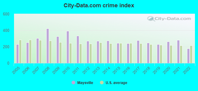
Crime rate in Maysville detailed stats: murders, rapes, robberies, assaults, burglaries, thefts, arson
Full-time law enforcement employees in 2021, including police officers: 36 (26 officers - 25 male; 1 female).
| Officers per 1,000 residents here: | 3.01 |
| Kentucky average: | 1.89 |
 Recent articles from our blog. Our writers, many of them Ph.D. graduates or candidates, create easy-to-read articles on a wide variety of topics.


Latest news from Maysville, KY collected exclusively by city-data.com from local newspapers, TV, and radio stations
Ancestries: American (40.5%), English (12.6%), Irish (11.7%), German (3.5%), Scottish (1.5%).
Current Local Time: EST time zone
Incorporated on 01/31/1833
Land area: 19.9 square miles.
Population density: 439 people per square mile (low).
243 residents are foreign born (1.3% Latin America, 0.6% Europe, 0.4% Asia, 0.3% Africa).
| This city: | 2.7% |
| Kentucky: | 4.1% |
Median real estate property taxes paid for housing units with mortgages in 2022: $1,503 (0.9%)
Median real estate property taxes paid for housing units with no mortgage in 2022: $1,154 (0.8%)
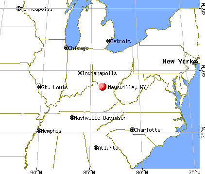
Nearest city with pop. 50,000+: Cincinnati, OH  (51.9 miles , pop. 331,285).
Nearest city with pop. 1,000,000+: Chicago, IL (302.2 miles , pop. 2,896,016).
Nearest cities:
), ), ), ), Latitude: 38.64 N, Longitude: 83.78 W
Daytime population change due to commuting: +3,526 (+39.8%)
Workers who live and work in this city: 2,787 (72.0%)
Area code: 606
Maysville, Kentucky accommodation & food services, waste management - Economy and Business Data
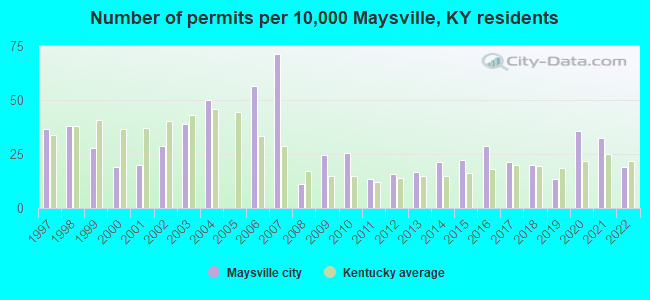
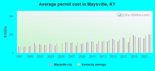
Single-family new house construction building permits:
- 2022: 17 buildings, average cost: $252,100
- 2021: 29 buildings, average cost: $199,800
- 2020: 32 buildings, average cost: $211,800
- 2019: 12 buildings, average cost: $244,800
- 2018: 18 buildings, average cost: $149,300
- 2017: 19 buildings, average cost: $215,300
- 2016: 26 buildings, average cost: $158,400
- 2015: 20 buildings, average cost: $196,400
- 2014: 19 buildings, average cost: $161,100
- 2013: 15 buildings, average cost: $158,500
- 2012: 14 buildings, average cost: $126,900
- 2011: 12 buildings, average cost: $162,100
- 2010: 23 buildings, average cost: $150,300
- 2009: 22 buildings, average cost: $127,500
- 2008: 10 buildings, average cost: $102,500
- 2007: 64 buildings, average cost: $142,000
- 2006: 51 buildings, average cost: $150,400
- 2004: 45 buildings, average cost: $104,700
- 2003: 35 buildings, average cost: $127,000
- 2002: 26 buildings, average cost: $114,000
- 2001: 18 buildings, average cost: $122,400
- 2000: 17 buildings, average cost: $135,600
- 1999: 25 buildings, average cost: $94,600
- 1998: 34 buildings, average cost: $87,700
- 1997: 33 buildings, average cost: $91,800
| Here: | 5.1% |
| Kentucky: | 3.8% |
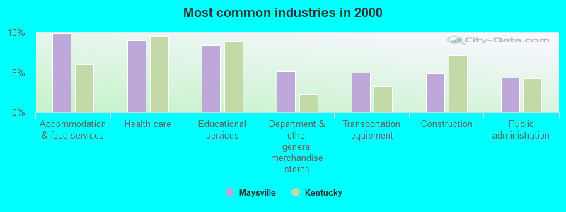
- Accommodation & food services (9.9%)
- Health care (9.0%)
- Educational services (8.4%)
- Department & other general merchandise stores (5.1%)
- Transportation equipment (4.9%)
- Construction (4.9%)
- Public administration (4.3%)
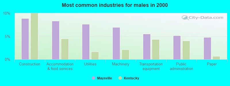
- Construction (8.9%)
- Accommodation & food services (8.3%)
- Utilities (7.7%)
- Machinery (6.9%)
- Transportation equipment (5.5%)
- Public administration (5.1%)
- Paper (4.8%)
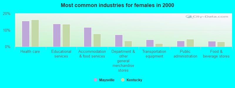
- Health care (15.5%)
- Educational services (13.8%)
- Accommodation & food services (11.7%)
- Department & other general merchandise stores (7.3%)
- Transportation equipment (4.3%)
- Public administration (3.5%)
- Food & beverage stores (3.4%)
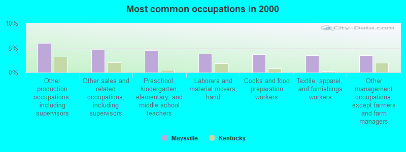
- Other production occupations, including supervisors (6.0%)
- Other sales and related occupations, including supervisors (4.6%)
- Preschool, kindergarten, elementary, and middle school teachers (4.5%)
- Laborers and material movers, hand (3.8%)
- Cooks and food preparation workers (3.7%)
- Textile, apparel, and furnishings workers (3.5%)
- Other management occupations, except farmers and farm managers (3.5%)
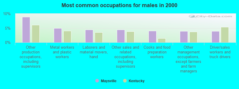
- Other production occupations, including supervisors (8.8%)
- Metal workers and plastic workers (5.0%)
- Laborers and material movers, hand (4.5%)
- Other sales and related occupations, including supervisors (4.4%)
- Cooks and food preparation workers (4.0%)
- Other management occupations, except farmers and farm managers (3.9%)
- Driver/sales workers and truck drivers (3.9%)
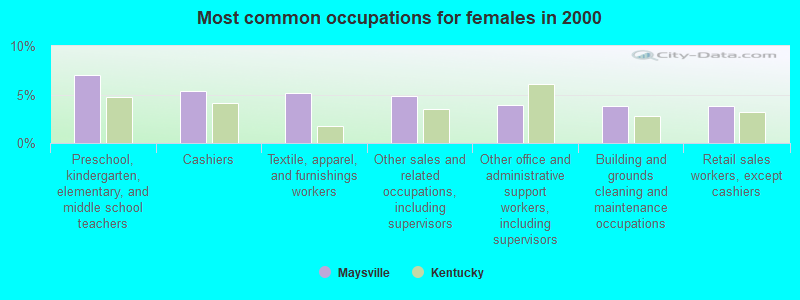
- Preschool, kindergarten, elementary, and middle school teachers (7.0%)
- Cashiers (5.3%)
- Textile, apparel, and furnishings workers (5.1%)
- Other sales and related occupations, including supervisors (4.9%)
- Other office and administrative support workers, including supervisors (4.0%)
- Building and grounds cleaning and maintenance occupations (3.9%)
- Retail sales workers, except cashiers (3.8%)
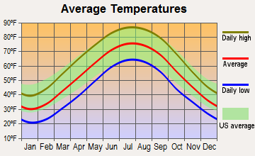
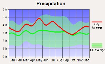
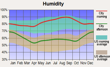
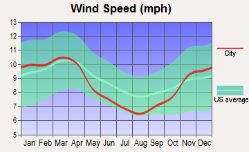
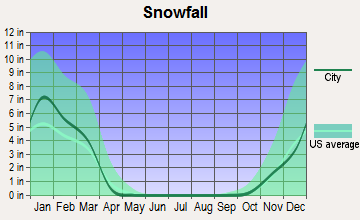
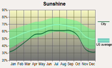
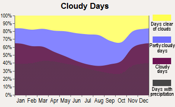
Average climate in Maysville, Kentucky
Based on data reported by over 4,000 weather stations
|
|

(lower is better)
Air Quality Index (AQI) level in 2020 was 57.1. This is better than average.
| City: | 57.1 |
| U.S.: | 72.6 |
Sulfur Dioxide (SO2) [ppb] level in 2020 was 0.213. This is significantly better than average. Closest monitor was 1.2 miles away from the city center.
| City: | 0.213 |
| U.S.: | 1.515 |
Particulate Matter (PM2.5) [µg/m3] level in 2020 was 7.41. This is about average. There were 0 monitors within city limits.
| City: | 7.41 |
| U.S.: | 8.11 |
Tornado activity:
Maysville-area historical tornado activity is slightly below Kentucky state average. It is 9% greater than the overall U.S. average.
On 5/10/2003, a category F3 (max. wind speeds 158-206 mph) tornado 3.4 miles away from the Maysville city center injured 17 people and caused $6 million in damages.
On 5/7/1967, a category F3 tornado 5.1 miles away from the city center caused between $5000 and $50,000 in damages.
Earthquake activity:
Maysville-area historical earthquake activity is significantly above Kentucky state average. It is 38% greater than the overall U.S. average.On 7/27/1980 at 18:52:21, a magnitude 5.2 (5.1 MB, 4.7 MS, 5.0 UK, 5.2 UK, Class: Moderate, Intensity: VI - VII) earthquake occurred 31.7 miles away from the city center
On 9/7/1988 at 02:28:09, a magnitude 4.6 (4.5 MB, 4.6 LG, Class: Light, Intensity: IV - V) earthquake occurred 35.1 miles away from Maysville center
On 4/18/2008 at 09:36:59, a magnitude 5.4 (5.1 MB, 4.8 MS, 5.4 MW, 5.2 MW) earthquake occurred 222.7 miles away from the city center
On 8/23/2011 at 17:51:04, a magnitude 5.8 (5.8 MW, Depth: 3.7 mi) earthquake occurred 321.1 miles away from the city center
On 4/18/2008 at 09:36:59, a magnitude 5.2 (5.2 MW, Depth: 8.9 mi) earthquake occurred 222.7 miles away from Maysville center
On 8/9/2020 at 12:07:37, a magnitude 5.1 (5.1 MW, Depth: 4.7 mi) earthquake occurred 210.0 miles away from the city center
Magnitude types: regional Lg-wave magnitude (LG), body-wave magnitude (MB), surface-wave magnitude (MS), moment magnitude (MW)
Natural disasters:
The number of natural disasters in Mason County (17) is near the US average (15).Major Disasters (Presidential) Declared: 13
Emergencies Declared: 3
Causes of natural disasters: Floods: 10, Storms: 9, Tornadoes: 5, Winter Storms: 5, Mudslides: 4, Blizzard: 1, Hurricane: 1, Landslide: 1, Snowfall: 1, Snowstorm: 1, Other: 1 (Note: some incidents may be assigned to more than one category).
Hospitals and medical centers in Maysville:
- HOSPICE OF HOPE INC (909 KENTON STATION ROAD)
- MEADOWVIEW REGIONAL MEDICAL CENTER (Proprietary, provides emergency services, 989 MEDICAL PARK DRIVE)
- MAYSVILLE EXTENDED CARE (620 PARKER RD)
- MAYSVILLE NURSING AND REHABILITATION FACILITY (620 PARKER ROAD)
- DAVITA - MAYSVILLE (489 TUCKER DRIVE)
- DCI - MAYSVILLE (1210 POPE DRIVE)
- HAYSWOOD HOME HEALTH SERVICES (1 WEST MCDONALD PARKWAY)
Heliports located in Maysville:
College/University in Maysville:
Other colleges/universities with over 2000 students near Maysville:
- Morehead State University (about 37 miles; Morehead, KY; Full-time enrollment: 7,523)
- University of Cincinnati-Clermont College (about 38 miles; Batavia, OH; FT enrollment: 2,739)
- Southern State Community College (about 42 miles; Hillsboro, OH; FT enrollment: 2,418)
- Shawnee State University (about 43 miles; Portsmouth, OH; FT enrollment: 4,160)
- Northern Kentucky University (about 46 miles; Highland Heights, KY; FT enrollment: 12,059)
- Gateway Community and Technical College (about 51 miles; Florence, KY; FT enrollment: 2,422)
- Xavier University (about 52 miles; Cincinnati, OH; FT enrollment: 6,143)
Public high school in Maysville:
- MASON COUNTY HIGH SCHOOL (Students: 793, Location: 1320 US 68, Grades: 9-12)
Private high school in Maysville:
Public elementary/middle schools in Maysville:
- MASON COUNTY INTERMEDIATE SCHOOL (Students: 647, Location: 720 CLARKS RUN RD, Grades: 3-5)
- CHARLES STRAUB ELEMENTARY SCHOOL (Students: 625, Location: 387 CHENAULT DR, Grades: PK-2)
- MASON COUNTY MIDDLE SCHOOL (Students: 607, Location: 420 CHENAULT DR, Grades: 6-8)
Points of interest:
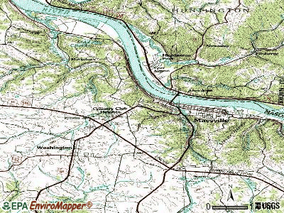
Notable locations in Maysville: Kirker Landing (A), The Upper Landing (B), Phister's Landing (C), Limestone Landing (D), Kenton Station Golf Course (E), Hamilton Landing (F), Coopers Landing (G), Maysville Country Club (H), Washington Volunteer Fire Department (I), Maysville Fire Department Station 2 (J), Maysville Fire Department (K), Regional Transport Ambulance Service (L), Maysville - Mason County Ambulance Service (M). Display/hide their locations on the map
Churches in Maysville include: Old Stone Church (A), Saint Patricks Church (B). Display/hide their locations on the map
Cemetery: Saint Patricks Cemetery (1). Display/hide its location on the map
Creeks: Limestone Creek (A), Lawrence Creek (B), Goose Creek (C). Display/hide their locations on the map
Parks in Maysville include: Mertz Memorial Playground (1), Wald Park (2). Display/hide their locations on the map
Tourist attractions: Harriet Beecher Stowe Museum (2124 Old Main Street) (1), Museum Center AKA Mason County Museum (215 Sutton Street) (2), Kentucky Off-Track Betting (Amusement & Theme Parks; 24 East 2nd Street) (3), Maysville Visitors' Center (115 East 3rd Street) (4). Display/hide their approximate locations on the map
Hotels: Maysville Motel (132 East 3rd Street) (1), Limestone Travel Agency (901 US Highway 68) (2), RIGG Motel (502 Forest Avenue) (3), Ramada Inn Maysville (484 Moody Drive) (4), French Quarter Inn (25 East McDonald Parkway) (5), Hampton Inn (503 Marketplace Drive) (6), Best Western Maysville Inn (1428A U South 68) (7), Victoria's (484 Moody Drive) (8). Display/hide their approximate locations on the map
Courts: Mason County District Court (110 East 3rd Street) (1), Kentucky State - Court Designated Worker (110 East 3rd Street) (2), Kentucky State - Court Of Justice- Circuit Court (110 East 3rd Street) (3), Kentucky State - Court Of Justice- Court Reporter (110 East 3rd Street) (4). Display/hide their approximate locations on the map
Birthplace of: Augustus E. Willson - Politician, William "Bull" Nelson - Union Army general, John S. Darrough - Army Medal of Honor recipient, Nelson Stacy - Race car driver, William Hopkinson Cox - Politician, Alison Lundergan Grimes - Kentucky politician, Darius Miller - Basketball player, Rosemary Clooney - (1928-2002), singer, William H. Wadsworth - Politician, Andrew McConnell January Cochran - Federal judge.
Drinking water stations with addresses in Maysville and their reported violations in the past:
MAYSVILLE UTILITY COMMISSION (Population served: 13,600, Surface water):Past monitoring violations:WESTERN LEWIS RECTORVILLE WATER DISTRICT (Population served: 6,534, Purch surface water):
- Monthly Turbidity Exceed (Enhanced SWTR) - In DEC-2013, Contaminant: IESWTR. Follow-up actions: St Public Notif requested (FEB-06-2014), St Formal NOV issued (FEB-06-2014), St Public Notif received (MAR-17-2014), St Compliance achieved (APR-15-2014)
- Monthly Turbidity Exceed (Enhanced SWTR) - In MAR-2012, Contaminant: IESWTR. Follow-up actions: St Public Notif requested (MAY-07-2012), St Formal NOV issued (MAY-07-2012), St Public Notif received (JUN-20-2012), St Compliance achieved (JUL-31-2012)
- Monitoring and Reporting (DBP) - Between JAN-2006 and MAR-2006, Contaminant: CARBON, TOTAL. Follow-up actions: St Public Notif requested (MAR-28-2006), St Formal NOV issued (MAR-28-2006), St Compliance achieved (FEB-06-2007), St Public Notif received (JUN-26-2007)
- Follow-up Or Routine LCR Tap M/R - In OCT-01-2005, Contaminant: Lead and Copper Rule. Follow-up actions: St Public Notif requested (MAY-10-2006), St Formal NOV issued (MAY-10-2006), St Public Notif received (JUN-27-2006), St Compliance achieved (JUL-12-2006)
- 22 regular monitoring violations
Past monitoring violations:BUFFALO TRAIL WATER ASSOC (Population served: 4,158, Purch surface water):
- Monitoring of Treatment (SWTR-Unfilt/GWR) - In JAN-2013, Contaminant: GROUNDWATER RULE. Follow-up actions: St Public Notif requested (MAR-15-2013), St Formal NOV issued (MAR-15-2013), St Compliance achieved (JUN-13-2013), St Public Notif received (JUL-18-2013)
- Monitoring of Treatment (SWTR-Unfilt/GWR) - In DEC-2012, Contaminant: GROUNDWATER RULE. Follow-up actions: St Public Notif requested (FEB-16-2013), St Formal NOV issued (FEB-16-2013), St Compliance achieved (JUN-13-2013), St Public Notif received (JUL-18-2013)
- Monitoring of Treatment (SWTR-Unfilt/GWR) - In AUG-2012, Contaminant: GROUNDWATER RULE. Follow-up actions: St Public Notif requested (OCT-15-2012), St Formal NOV issued (OCT-15-2012), St Compliance achieved (DEC-28-2012), St Public Notif received (JUL-18-2013)
- Monitoring of Treatment (SWTR-Unfilt/GWR) - In DEC-2011, Contaminant: GROUNDWATER RULE. Follow-up actions: St Public Notif requested (FEB-09-2012), St Formal NOV issued (FEB-09-2012), St Compliance achieved (MAR-29-2012), St Public Notif received (APR-02-2012)
- Monitoring of Treatment (SWTR-Unfilt/GWR) - In NOV-2011, Contaminant: GROUNDWATER RULE. Follow-up actions: St Public Notif requested (JAN-16-2012), St Formal NOV issued (JAN-16-2012), St Compliance achieved (MAR-29-2012), St Public Notif received (APR-02-2012)
- 2 minor monitoring violations
- 12 other older monitoring violations
Past health violations:Past monitoring violations:
- MCL, Monthly (TCR) - In DEC-2009, Contaminant: Coliform. Follow-up actions: St Public Notif requested (JAN-29-2010), St Formal NOV issued (JAN-29-2010), St Public Notif received (MAR-04-2010), St Compliance achieved (MAY-18-2010)
- Monitoring of Treatment (SWTR-Filter) - In APR-2012. Follow-up actions: St Public Notif requested (JUN-24-2012), St Formal NOV issued (JUN-24-2012), St Compliance achieved (SEP-06-2012)
- Follow-up Or Routine LCR Tap M/R - In OCT-01-2003, Contaminant: Lead and Copper Rule. Follow-up actions: St Public Notif requested (MAY-09-2006), St Formal NOV issued (MAY-09-2006), St Compliance achieved (JUN-27-2006), St Public Notif received (AUG-10-2007)
- One minor monitoring violation
| This city: | 2.3 people |
| Kentucky: | 2.5 people |
| This city: | 61.4% |
| Whole state: | 66.9% |
| This city: | 7.5% |
| Whole state: | 6.4% |
Likely homosexual households (counted as self-reported same-sex unmarried-partner households)
- Lesbian couples: 0.3% of all households
- Gay men: 0.4% of all households
People in group quarters in Maysville in 2010:
- 164 people in local jails and other municipal confinement facilities
- 126 people in nursing facilities/skilled-nursing facilities
- 8 people in other noninstitutional facilities
People in group quarters in Maysville in 2000:
- 179 people in nursing homes
- 121 people in local jails and other confinement facilities (including police lockups)
- 11 people in homes for the mentally retarded
- 9 people in other noninstitutional group quarters
Banks with branches in Maysville (2011 data):
- Bank of Maysville: Aa Highway Branch, Maysville Branch, Bank Of Maysville. Info updated 2006/11/03: Bank assets: $117.8 mil, Deposits: $94.7 mil, local headquarters, positive income, 3 total offices, Holding Company: First Bank Of Kentucky Corporation
- Security Bank and Trust Co.: Security Bank And Trust Co., U.S. 68 Branch, Drive-In Branch. Info updated 2006/11/03: Bank assets: $47.5 mil, Deposits: $37.1 mil, local headquarters, positive income, Commercial Lending Specialization, 3 total offices, Holding Company: Security Bancorp Of Maysville, Inc.
- U.S. Bank National Association: Maysville U.S. 68 Branch at 1176 U.S. Highway 68, branch established on 1978/04/27; Maysville Branch at 33 West Second Street, branch established on 1882/03/27. Info updated 2012/01/30: Bank assets: $330,470.8 mil, Deposits: $236,091.5 mil, headquarters in Cincinnati, OH, positive income, 3121 total offices, Holding Company: U.S. Bancorp
- Peoples Bank of Kentucky, Inc.: Tucker Drive Branch at 90 Tucker Drive, branch established on 2006/07/01. Info updated 2007/06/06: Bank assets: $191.6 mil, Deposits: $158.5 mil, headquarters in Flemingsburg, KY, positive income, Agricultural Specialization, 6 total offices, Holding Company: Peoples Of Fleming County Bancorp, Inc.
- Citizens Deposit Bank & Trust: Maysville Branch at 1201 Ushwy 68, branch established on 1847/01/01. Info updated 2010/09/27: Bank assets: $212.9 mil, Deposits: $183.5 mil, headquarters in Vanceburg, KY, positive income, Commercial Lending Specialization, 9 total offices, Holding Company: Premier Financial Bancorp, Inc.
For population 15 years and over in Maysville:
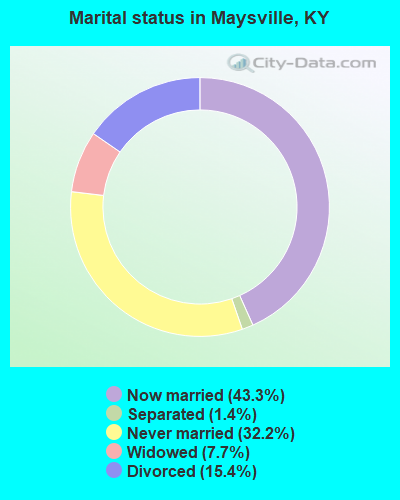
- Never married: 32.2%
- Now married: 43.3%
- Separated: 1.4%
- Widowed: 7.7%
- Divorced: 15.4%
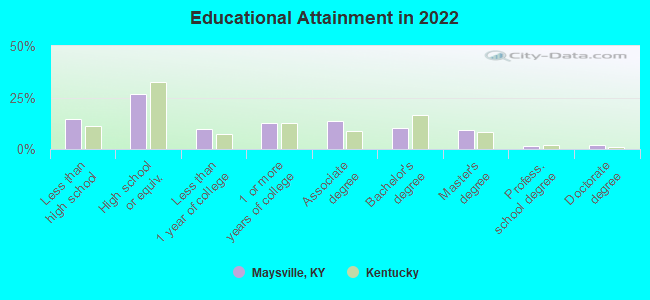
For population 25 years and over in Maysville:
- High school or higher: 84.0%
- Bachelor's degree or higher: 21.8%
- Graduate or professional degree: 12.0%
- Unemployed: 6.7%
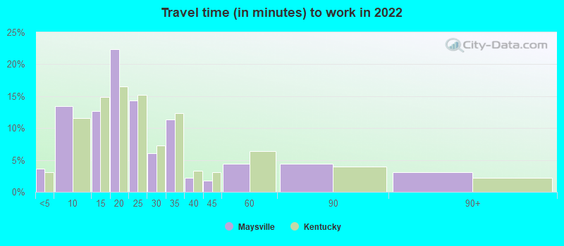
- Mean travel time to work (commute): 19.6 minutes
| Here: | 13.0 |
| Kentucky average: | 11.7 |
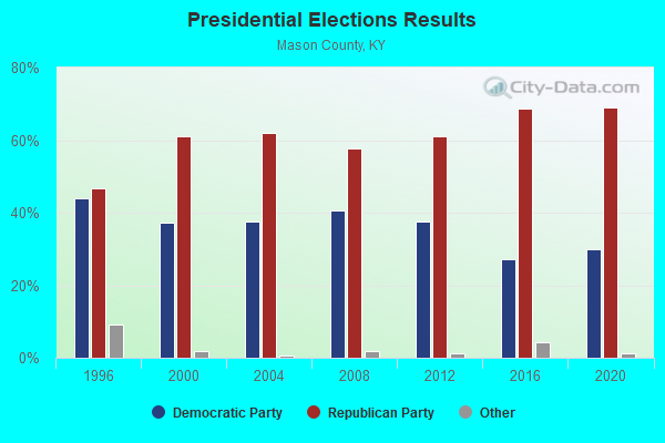
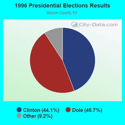
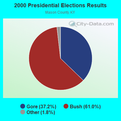
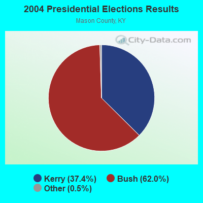
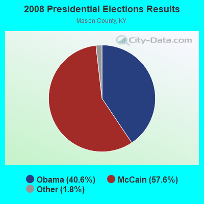
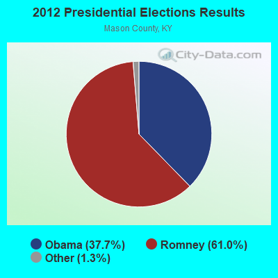
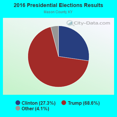
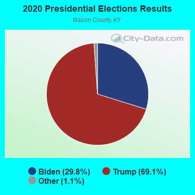
Graphs represent county-level data. Detailed 2008 Election Results
Religion statistics for Maysville, KY (based on Mason County data)
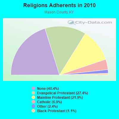
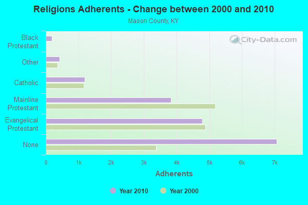
| Religion | Adherents | Congregations |
|---|---|---|
| Evangelical Protestant | 4,790 | 30 |
| Mainline Protestant | 3,822 | 24 |
| Catholic | 1,200 | 3 |
| Other | 426 | 2 |
| Black Protestant | 185 | 1 |
| None | 7,067 | - |
Food Environment Statistics:
| Mason County: | 2.32 / 10,000 pop. |
| Kentucky: | 2.19 / 10,000 pop. |
| Mason County: | 0.58 / 10,000 pop. |
| Kentucky: | 0.25 / 10,000 pop. |
| This county: | 8.13 / 10,000 pop. |
| Kentucky: | 4.36 / 10,000 pop. |
| Here: | 8.13 / 10,000 pop. |
| Kentucky: | 5.74 / 10,000 pop. |
| This county: | 11.9% |
| Kentucky: | 11.0% |
| This county: | 29.9% |
| State: | 30.0% |
| Here: | 16.0% |
| Kentucky: | 15.9% |
Health and Nutrition:
| Maysville: | 46.5% |
| Kentucky: | 49.9% |
| Maysville: | 38.8% |
| Kentucky: | 47.0% |
| Maysville: | 28.0 |
| Kentucky: | 28.6 |
| This city: | 17.0% |
| State: | 21.0% |
| Maysville: | 8.2% |
| Kentucky: | 10.1% |
| Maysville: | 6.7 |
| Kentucky: | 6.8 |
| This city: | 28.8% |
| Kentucky: | 33.8% |
| Maysville: | 51.8% |
| State: | 56.8% |
| This city: | 75.2% |
| Kentucky: | 78.9% |
More about Health and Nutrition of Maysville, KY Residents
| Local government employment and payroll (March 2022) | |||||
| Function | Full-time employees | Monthly full-time payroll | Average yearly full-time wage | Part-time employees | Monthly part-time payroll |
|---|---|---|---|---|---|
| Firefighters | 27 | $119,370 | $53,053 | 0 | $0 |
| Police Protection - Officers | 26 | $140,753 | $64,963 | 0 | $0 |
| Water Supply | 20 | $59,635 | $35,781 | 1 | $680 |
| Other and Unallocable | 11 | $34,381 | $37,507 | 1 | $2,533 |
| Housing and Community Development (Local) | 11 | $38,084 | $41,546 | 4 | $3,342 |
| Police - Other | 10 | $30,194 | $36,233 | 2 | $198 |
| Sewerage | 9 | $29,829 | $39,772 | 0 | $0 |
| Streets and Highways | 8 | $35,619 | $53,429 | 0 | $0 |
| Solid Waste Management | 7 | $17,593 | $30,159 | 0 | $0 |
| Other Government Administration | 6 | $30,431 | $60,862 | 6 | $8,979 |
| Transit | 3 | $9,302 | $37,208 | 1 | $545 |
| Welfare | 3 | $7,779 | $31,116 | 0 | $0 |
| Natural Resources | 3 | $18,410 | $73,640 | 0 | $0 |
| Financial Administration | 2 | $12,280 | $73,680 | 0 | $0 |
| Parks and Recreation | 2 | $5,824 | $34,944 | 0 | $0 |
| Judicial and Legal | 1 | $2,292 | $27,504 | 1 | $1,477 |
| Fire - Other | 0 | $0 | 11 | $5,586 | |
| Totals for Government | 149 | $591,775 | $47,660 | 27 | $23,340 |
Maysville government finances - Expenditure in 2021 (per resident):
- Construction - Sewerage: $422,000 ($48.27)
Housing and Community Development: $195,000 ($22.31)
Water Utilities: $113,000 ($12.93)
Parks and Recreation: $50,000 ($5.72)
- Current Operations - Water Utilities: $2,285,000 ($261.38)
Sewerage: $1,973,000 ($225.69)
Regular Highways: $1,860,000 ($212.77)
Local Fire Protection: $1,817,000 ($207.85)
Police Protection: $1,761,000 ($201.44)
Central Staff Services: $1,316,000 ($150.54)
Housing and Community Development: $917,000 ($104.90)
General - Other: $622,000 ($71.15)
Solid Waste Management: $501,000 ($57.31)
Parks and Recreation: $298,000 ($34.09)
Transit Utilities: $242,000 ($27.68)
Protective Inspection and Regulation - Other: $174,000 ($19.90)
Miscellaneous Commercial Activities - Other: $154,000 ($17.62)
- General - Interest on Debt: $269,000 ($30.77)
- Intergovernmental to Local - Other - General - Other: $139,000 ($15.90)
Other - Housing and Community Development: $39,000 ($4.46)
- Other Capital Outlay - Regular Highways: $596,000 ($68.18)
Police Protection: $185,000 ($21.16)
Transit Utilities: $166,000 ($18.99)
Local Fire Protection: $157,000 ($17.96)
Water Utilities: $152,000 ($17.39)
Sewerage: $55,000 ($6.29)
General - Other: $51,000 ($5.83)
Housing and Community Development: $46,000 ($5.26)
Health - Other: $15,000 ($1.72)
Parks and Recreation: $10,000 ($1.14)
- Total Salaries and Wages: $6,554,000 ($749.71)
Maysville government finances - Revenue in 2021 (per resident):
- Charges - Sewerage: $2,407,000 ($275.34)
Other: $1,541,000 ($176.28)
Housing and Community Development: $737,000 ($84.31)
Solid Waste Management: $487,000 ($55.71)
Miscellaneous Commercial Activities: $116,000 ($13.27)
Parks and Recreation: $38,000 ($4.35)
- Federal Intergovernmental - Transit Utilities: $443,000 ($50.67)
General Local Government Support: $197,000 ($22.53)
Sewerage: $72,000 ($8.24)
Highways: $37,000 ($4.23)
Other: $23,000 ($2.63)
Health and Hospitals: $15,000 ($1.72)
- Local Intergovernmental - Other: $589,000 ($67.38)
Sewerage: $71,000 ($8.12)
Housing and Community Development: $39,000 ($4.46)
- Miscellaneous - Rents: $326,000 ($37.29)
Interest Earnings: $231,000 ($26.42)
Sale of Property: $37,000 ($4.23)
Fines and Forfeits: $30,000 ($3.43)
General Revenue - Other: $5,000 ($0.57)
Donations From Private Sources: $3,000 ($0.34)
- Revenue - Water Utilities: $1,864,000 ($213.22)
Transit Utilities: $1,000 ($0.11)
- State Intergovernmental - Other: $302,000 ($34.55)
Highways: $173,000 ($19.79)
- Tax - Individual Income: $6,461,000 ($739.08)
Property: $1,370,000 ($156.71)
Insurance Premiums Sales: $1,279,000 ($146.31)
Public Utilities Sales: $1,009,000 ($115.42)
Corporation Net Income: $729,000 ($83.39)
Other Selective Sales: $196,000 ($22.42)
Alcoholic Beverage License: $27,000 ($3.09)
Other License: $22,000 ($2.52)
Maysville government finances - Debt in 2021 (per resident):
- Long Term Debt - Beginning Outstanding - Public Debt for Private Purpose: $149,000,000 ($17044.15)
Outstanding Nonguaranteed - Industrial Revenue: $149,000,000 ($17044.15)
Beginning Outstanding - Unspecified Public Purpose: $14,002,000 ($1601.69)
Outstanding Unspecified Public Purpose: $13,833,000 ($1582.36)
Retired Unspecified Public Purpose: $717,000 ($82.02)
Issue, Unspecified Public Purpose: $548,000 ($62.69)
Maysville government finances - Cash and Securities in 2021 (per resident):
- Other Funds - Cash and Securities: $20,947,000 ($2396.13)
- Sinking Funds - Cash and Securities: $149,127,000 ($17058.68)
| Businesses in Maysville, KY | ||||
| Name | Count | Name | Count | |
|---|---|---|---|---|
| AT&T | 1 | Lane Furniture | 2 | |
| Advance Auto Parts | 1 | Little Caesars Pizza | 1 | |
| Applebee's | 1 | Long John Silver's | 1 | |
| Arby's | 1 | Lowe's | 1 | |
| AutoZone | 1 | MasterBrand Cabinets | 6 | |
| Best Western | 1 | McDonald's | 1 | |
| Burger King | 1 | Nike | 1 | |
| Chevrolet | 1 | Pizza Hut | 1 | |
| Curves | 1 | RadioShack | 1 | |
| Days Inn | 1 | Rite Aid | 1 | |
| Domino's Pizza | 1 | SONIC Drive-In | 1 | |
| FedEx | 2 | Sears | 1 | |
| GNC | 2 | Subway | 2 | |
| GameStop | 1 | Super 8 | 1 | |
| Goodwill | 3 | Taco Bell | 1 | |
| H&R Block | 2 | U-Haul | 2 | |
| Hardee's | 1 | UPS | 3 | |
| JCPenney | 1 | Vans | 2 | |
| Kmart | 1 | Walmart | 1 | |
| Kroger | 1 | Wendy's | 1 | |
| La-Z-Boy | 1 | YMCA | 1 | |
Strongest AM radio stations in Maysville:
- WFTM (1240 AM; 1 kW; MAYSVILLE, KY; Owner: STANDARD TABACCO CO.)
- WLW (700 AM; 50 kW; CINCINNATI, OH; Owner: JACOR BROADCASTING CORPORATION)
- WTVN (610 AM; 50 kW; COLUMBUS, OH; Owner: CITICASTERS LICENSES, L.P.)
- WSAI (1530 AM; 50 kW; CINCINNATI, OH; Owner: JACOR BROADCASTING CORPORATION)
- WHAS (840 AM; 50 kW; LOUISVILLE, KY; Owner: CLEAR CHANNEL BROADCASTING LICENSES, INC.)
- WKRC (550 AM; 5 kW; CINCINNATI, OH; Owner: JACOR BROADCASTING CORPORATION)
- WLAP (630 AM; 5 kW; LEXINGTON, KY; Owner: CITICASTERS LICENSES, L.P.)
- WRFD (880 AM; daytime; 23 kW; COLUMBUS-WORTHINGTON, OH; Owner: SALEM MEDIA OF OHIO, INC.)
- WFLE (1060 AM; daytime; 0 kW; FLEMINGSBURG, KY; Owner: FLEMING COUNTY BROADCASTING CO., INC)
- WVLK (590 AM; 5 kW; LEXINGTON, KY; Owner: CUMULUS LICENSING CORP.)
- WXRA (1580 AM; 10 kW; GEORGETOWN, KY; Owner: CITICASTERS LICENSES, L.P.)
- WNXT (1260 AM; 5 kW; PORTSMOUTH, OH; Owner: HOMETOWN B/C OF PORTSMOUTH, INC.)
- WKVL (850 AM; daytime; 50 kW; KNOXVILLE, TN; Owner: HORNE RADIO, LLC)
Strongest FM radio stations in Maysville:
- WFTM-FM (95.9 FM; MAYSVILLE, KY; Owner: STANDARD TOBACCO COMPANY, INC.)
- WAGX (101.3 FM; MANCHESTER, OH; Owner: JEWELL SCHAEFFER BROADCASTING CO.)
- WAOL (99.5 FM; RIPLEY, OH; Owner: RICHARD L. PLESSINGER, SR.)
- WFLE-FM (95.1 FM; FLEMINGSBURG, KY; Owner: FLEMING COUNTY BROADCASTING CO., INC)
- WPAY-FM (104.1 FM; PORTSMOUTH, OH; Owner: RADIO STATIONS WPAY/WPFB, INC.)
- WAXZ (97.7 FM; GEORGETOWN, OH; Owner: RICHARD L. PLESSINGER, SR.)
- WRAC (103.1 FM; WEST UNION, OH; Owner: DREAMCATCHER COMMUNICATIONS, INC.)
- WOSP (91.5 FM; PORTSMOUTH, OH; Owner: THE OHIO STATE UNIVERSITY)
- WBVX (92.1 FM; CARLISLE, KY; Owner: L.M. COMMUNICATIONS OF KENTUCKY, LLC)
- WVXW (89.5 FM; WEST UNION, OH; Owner: XAVIER UNIVERSITY)
- WMKY (90.3 FM; MOREHEAD, KY; Owner: MOREHEAD STATE UNIVERSITY)
- WIOK (107.5 FM; FALMOUTH, KY; Owner: HAMMOND BROADCASTING, INC.)
- WKKS-FM (104.9 FM; VANCEBURG, KY; Owner: BROWN COMMUNICATIONS, INC.)
TV broadcast stations around Maysville:
- WPBO (Channel 42; PORTSMOUTH, OH; Owner: THE OHIO STATE UNIVERSITY)
- WHCP (Channel 30; PORTSMOUTH, OH; Owner: TELEVISION PROPERTIES, INC.)

- National Bridge Inventory (NBI) Statistics
- 58Number of bridges
- 1,024ft / 312mTotal length
- $11,812,000Total costs
- 141,935Total average daily traffic
- 14,929Total average daily truck traffic
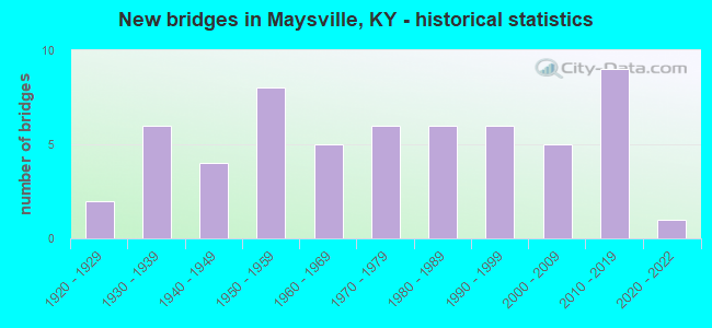
- New bridges - historical statistics
- 21920-1929
- 61930-1939
- 41940-1949
- 81950-1959
- 51960-1969
- 61970-1979
- 61980-1989
- 61990-1999
- 52000-2009
- 92010-2019
- 12020-2022
FCC Registered Antenna Towers: 85 (See the full list of FCC Registered Antenna Towers)
FCC Registered Commercial Land Mobile Towers: 1 (See the full list of FCC Registered Commercial Land Mobile Towers in Maysville, KY)
FCC Registered Private Land Mobile Towers: 1 (See the full list of FCC Registered Private Land Mobile Towers)
FCC Registered Broadcast Land Mobile Towers: 30 (See the full list of FCC Registered Broadcast Land Mobile Towers)
FCC Registered Microwave Towers: 18 (See the full list of FCC Registered Microwave Towers in this town)
FCC Registered Paging Towers: 1 (See the full list of FCC Registered Paging Towers)
FCC Registered Maritime Coast & Aviation Ground Towers: 5 (See the full list of FCC Registered Maritime Coast & Aviation Ground Towers)
FCC Registered Amateur Radio Licenses: 120 (See the full list of FCC Registered Amateur Radio Licenses in Maysville)
FAA Registered Aircraft: 9 (See the full list of FAA Registered Aircraft in Maysville)
2002 - 2018 National Fire Incident Reporting System (NFIRS) incidents
- Fire incident types reported to NFIRS in Maysville, KY
- 45741.7%Structure Fires
- 30427.7%Outside Fires
- 26424.1%Mobile Property/Vehicle Fires
- 726.6%Other
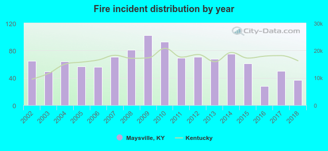 Based on the data from the years 2002 - 2018 the average number of fires per year is 65. The highest number of reported fire incidents - 102 took place in 2009, and the least - 28 in 2016. The data has a decreasing trend.
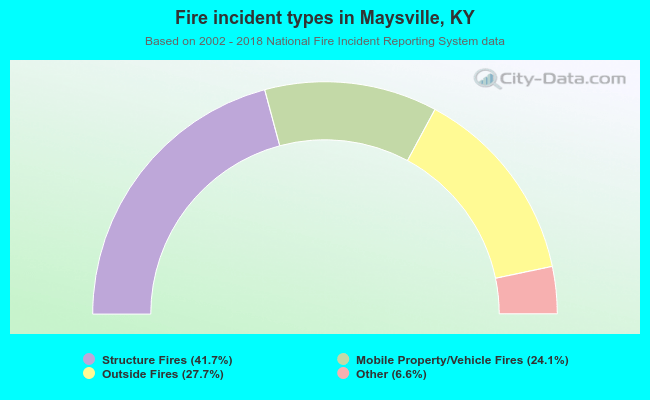 When looking into fire subcategories, the most reports belonged to: Structure Fires (41.7%), and Outside Fires (27.7%).
Fire-safe hotels and motels in Maysville, Kentucky:
- Days Inn - Maysville, 484 Moody Dr, Maysville, Kentucky 41056 , Phone: (606) 564-6793, Fax: (606) 564-4486
- Super 8 Maysville OH, 550 Tucker Dr, Maysville, Kentucky 41056 , Phone: (606) 759-8888, Fax: (606) 759-8888
- Hampton Inn, 503 Market Place Dr, Maysville, Kentucky 41056 , Phone: (606) 759-0600, Fax: (606) 759-0601
| Most common first names in Maysville, KY among deceased individuals | ||
| Name | Count | Lived (average) |
|---|---|---|
| Mary | 182 | 79.2 years |
| William | 171 | 74.3 years |
| John | 145 | 73.7 years |
| Charles | 144 | 71.3 years |
| James | 141 | 73.2 years |
| Robert | 95 | 71.6 years |
| Anna | 66 | 80.4 years |
| Elizabeth | 65 | 78.0 years |
| George | 64 | 74.0 years |
| Margaret | 56 | 80.4 years |
| Most common last names in Maysville, KY among deceased individuals | ||
| Last name | Count | Lived (average) |
|---|---|---|
| Jones | 47 | 72.3 years |
| Moran | 47 | 75.3 years |
| Thomas | 39 | 75.6 years |
| Wallingford | 38 | 78.3 years |
| Johnson | 37 | 75.6 years |
| Parker | 37 | 74.9 years |
| Wilson | 35 | 70.6 years |
| Applegate | 35 | 79.2 years |
| Davis | 34 | 73.9 years |
| Cooper | 31 | 78.0 years |
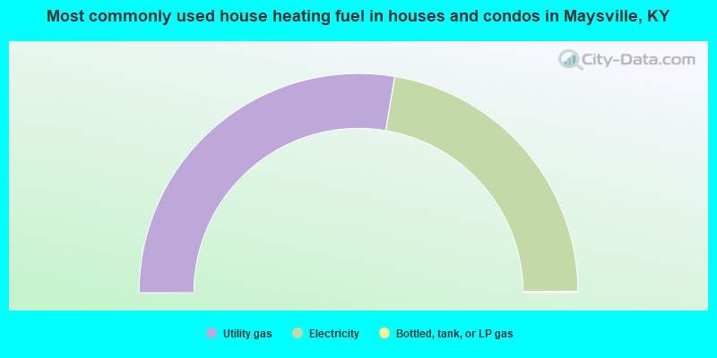
- 55.3%Utility gas
- 44.5%Electricity
- 0.2%Bottled, tank, or LP gas
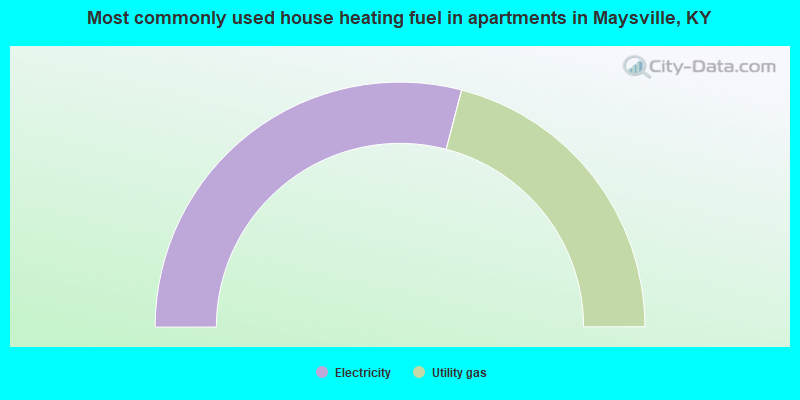
- 58.1%Electricity
- 41.9%Utility gas
Maysville compared to Kentucky state average:
- Unemployed percentage below state average.
- Foreign-born population percentage below state average.
- Length of stay since moving in significantly above state average.
Maysville on our top lists:
- #52 on the list of "Top 101 cities with largest percentage of females in occupations: health technologists and technicians (population 5,000+)"

|
|
Total of 11 patent applications in 2008-2024.