Nevada, Missouri
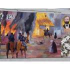
Nevada: Mural Project- Nevada, MO
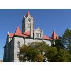
Nevada: Nevada-Vernon County Courthouse

Nevada: Vernon County Courthouse, Nevada, MO
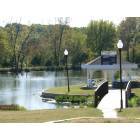
Nevada: Radio Springs Park- Nevada, MO
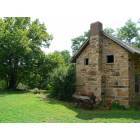
Nevada: Old Stone House- Nevada, MO
- add
your
Submit your own pictures of this city and show them to the world
- OSM Map
- General Map
- Google Map
- MSN Map
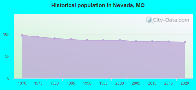
Population change since 2000: -4.7%
 |
| Males: 3,775 | |
| Females: 4,430 |
| Median resident age: | 38.7 years |
| Missouri median age: | 39.1 years |
Zip codes: 64772.
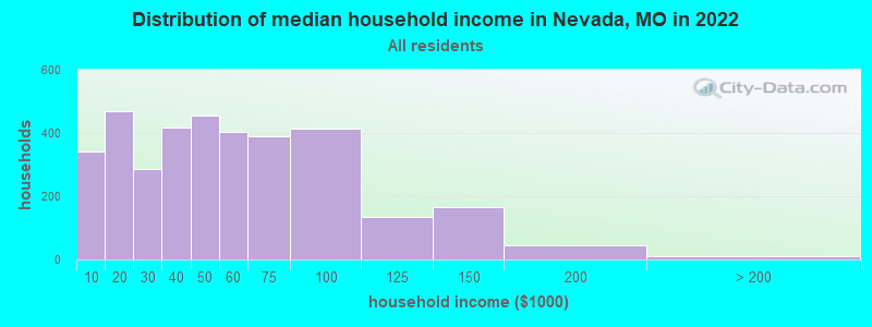
| Nevada: | $43,572 |
| MO: | $64,811 |
Estimated per capita income in 2022: $22,957 (it was $15,118 in 2000)
Nevada city income, earnings, and wages data
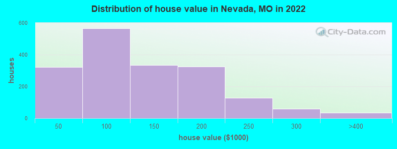
Estimated median house or condo value in 2022: $112,597 (it was $57,500 in 2000)
| Nevada: | $112,597 |
| MO: | $221,200 |
Mean prices in 2022: all housing units: $147,433; detached houses: $144,963; townhouses or other attached units: $155,581
Median gross rent in 2022: $704.
(23.4% for White Non-Hispanic residents, 38.9% for two or more races residents)
Detailed information about poverty and poor residents in Nevada, MO

Compare current foreclosures near Nevada, MO:
| Photo | Address | Area | Beds / Baths | Price | Details |
|---|---|---|---|---|---|

|
#1
N Adams St
Nevada, MO 64772
|
920 sq. feet
|
1 baths 2 beds |
show details | |

|
#2
E Wooter St
Nevada, MO 64772
|
1,456 sq. feet
|
2 baths 3 beds |
show details | |

|
#3
N Main St
Nevada, MO 64772
|
1,128 sq. feet
|
1 baths 3 beds |
show details | |

|
#4
N Cedar St
Nevada, MO 64772
|
1,172 sq. feet
|
1 baths 2 beds |
show details | |

|
#5
N Cedar St
Nevada, MO 64772
|
2,574 sq. feet
|
1 baths 2 beds |
show details | |

|
#6
N Olive St
Nevada, MO 64772
|
993 sq. feet
|
2 baths 3 beds |
show details | |

|
#7
S College St
Nevada, MO 64772
|
1,790 sq. feet
|
2 baths 3 beds |
show details | |

|
#8
S Cedar St
Nevada, MO 64772
|
2,576 sq. feet
|
2 baths 4 beds |
show details | |

|
#9
N Oak St
Nevada, MO 64772
|
956 sq. feet
|
1 baths 2 beds |
show details | |

|
#10
S 1491 Rd
Nevada, MO 64772
|
1,125 sq. feet
|
1 baths 3 beds |
show details |
| Photo | Address | Area | Beds / Baths | Price | Details |
|---|---|---|---|---|---|

|
#11
S 1244 Rd
Nevada, MO 64772
|
- sq. feet
|
- baths - beds |
show details | |

|
#12
S Prewitt St
Nevada, MO 64772
|
- sq. feet
|
- baths - beds |
show details | |

|
#13
S 2350 Rd
Nevada, MO 64772
|
- sq. feet
|
- baths - beds |
show details | |

|
#14
E Walkaway Rd
Sheldon, MO 64784
|
1,280 sq. feet
|
1 baths 2 beds |
show details | |

|
#15
S 2550 Rd
El Dorado Springs, MO 64744
|
1,568 sq. feet
|
1 baths 2 beds |
show details | |

|
#16
E Marvin Ave
Walker, MO 64790
|
- sq. feet
|
- baths - beds |
show details | |

|
#17
S 2325 Rd
Sheldon, MO 64784
|
- sq. feet
|
- baths - beds |
show details | |

|
Check over 1 million property listings on Foreclosure.com!
|
browse all offers | |||


- 7,23288.6%White alone
- 4505.5%Two or more races
- 3454.2%Hispanic
- 941.2%Black alone
- 410.5%Asian alone
- 120.1%American Indian alone
- 10.01%Other race alone
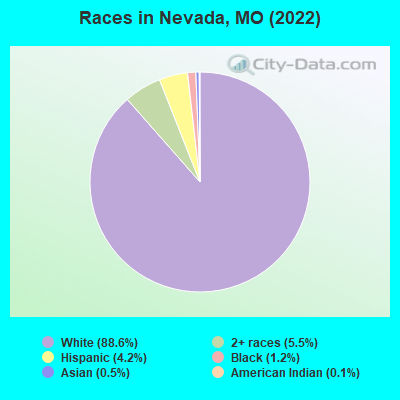
Races in Nevada detailed stats: ancestries, foreign born residents, place of birth
According to our research of Missouri and other state lists, there were 52 registered sex offenders living in Nevada, Missouri as of April 26, 2024.
The ratio of all residents to sex offenders in Nevada is 162 to 1.
Type |
2009 |
2010 |
2011 |
2012 |
2013 |
2014 |
2015 |
2016 |
2017 |
2018 |
2019 |
2020 |
2021 |
2022 |
|---|---|---|---|---|---|---|---|---|---|---|---|---|---|---|
| Murders (per 100,000) | 2 (24.1) | 0 (0.0) | 0 (0.0) | 0 (0.0) | 0 (0.0) | 0 (0.0) | 0 (0.0) | 1 (12.2) | 0 (0.0) | 0 (0.0) | 1 (12.1) | 0 (0.0) | 2 (24.5) | 0 (0.0) |
| Rapes (per 100,000) | 3 (36.1) | 4 (47.7) | 3 (35.6) | 3 (36.0) | 4 (49.3) | 3 (36.3) | 2 (24.2) | 6 (72.9) | 5 (61.0) | 2 (24.6) | 8 (97.1) | 13 (157.7) | 18 (220.1) | 22 (268.9) |
| Robberies (per 100,000) | 4 (48.2) | 4 (47.7) | 7 (83.2) | 9 (108.1) | 4 (49.3) | 2 (24.2) | 7 (84.6) | 4 (48.6) | 7 (85.4) | 4 (49.3) | 1 (12.1) | 5 (60.6) | 3 (36.7) | 1 (12.2) |
| Assaults (per 100,000) | 35 (421.7) | 58 (691.6) | 51 (606.0) | 37 (444.3) | 38 (468.6) | 57 (690.3) | 75 (906.3) | 48 (583.2) | 48 (585.5) | 38 (468.2) | 11 (133.5) | 121 (1,467) | 68 (831.6) | 52 (635.5) |
| Burglaries (per 100,000) | 73 (879.6) | 108 (1,288) | 121 (1,438) | 140 (1,681) | 146 (1,800) | 120 (1,453) | 118 (1,426) | 110 (1,337) | 98 (1,195) | 78 (961.1) | 50 (607.0) | 51 (618.5) | 33 (403.6) | 39 (476.7) |
| Thefts (per 100,000) | 474 (5,712) | 370 (4,412) | 468 (5,561) | 684 (8,213) | 570 (7,028) | 424 (5,135) | 446 (5,390) | 426 (5,176) | 458 (5,587) | 370 (4,559) | 389 (4,723) | 388 (4,705) | 376 (4,598) | 371 (4,534) |
| Auto thefts (per 100,000) | 21 (253.0) | 21 (250.4) | 29 (344.6) | 44 (528.3) | 40 (493.2) | 25 (302.8) | 24 (290.0) | 18 (218.7) | 35 (426.9) | 24 (295.7) | 22 (267.1) | 38 (460.8) | 49 (599.2) | 32 (391.1) |
| Arson (per 100,000) | 3 (36.1) | 2 (23.8) | 5 (59.4) | 2 (24.0) | 2 (24.7) | 10 (121.1) | 3 (36.3) | 3 (36.5) | 8 (97.6) | 3 (37.0) | 1 (12.1) | 1 (12.1) | 3 (36.7) | 2 (24.4) |
| City-Data.com crime index | 486.2 | 477.5 | 525.3 | 638.6 | 594.6 | 505.8 | 564.6 | 532.0 | 532.8 | 401.4 | 385.1 | 706.2 | 662.5 | 591.9 |
The City-Data.com crime index weighs serious crimes and violent crimes more heavily. Higher means more crime, U.S. average is 246.1. It adjusts for the number of visitors and daily workers commuting into cities.
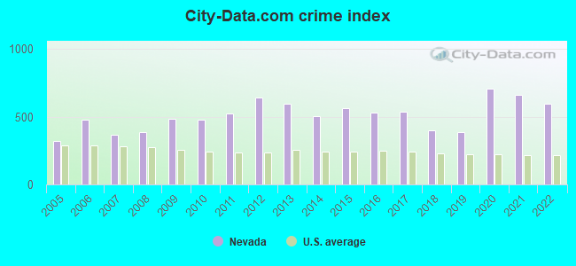
Crime rate in Nevada detailed stats: murders, rapes, robberies, assaults, burglaries, thefts, arson
Full-time law enforcement employees in 2019, including police officers: 25 (21 officers - 16 male; 5 female).
| Officers per 1,000 residents here: | 2.55 |
| Missouri average: | 2.48 |
 Recent articles from our blog. Our writers, many of them Ph.D. graduates or candidates, create easy-to-read articles on a wide variety of topics.

 | Is the ‘Midwesternness’ of Northern Missouri overstated? (99 replies) |
| Missouri Outlaw History (3407 replies) |
| Any differences between rural towns outside KC versus STL (16 replies) |
| Question about Nevada, Mo. Considering retirement there. (1 reply) |
| Is St. Louis a Southern city? (755 replies) |
| Interesting Missouri facts. (1186 replies) |
Latest news from Nevada, MO collected exclusively by city-data.com from local newspapers, TV, and radio stations
Ancestries: American (30.7%), German (10.2%), English (6.0%), Irish (5.5%), Scottish (5.1%), European (3.5%).
Current Local Time: CST time zone
Incorporated in 1880
Elevation: 880 feet
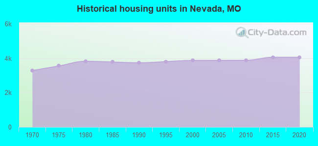
Land area: 8.93 square miles.
Population density: 919 people per square mile (low).
140 residents are foreign born
| This city: | 1.7% |
| Missouri: | 4.2% |
Median real estate property taxes paid for housing units with mortgages in 2022: $899 (0.9%)
Median real estate property taxes paid for housing units with no mortgage in 2022: $1,074 (0.8%)
Nearest city with pop. 50,000+: Springfield, MO  (73.7 miles , pop. 151,580).
Nearest city with pop. 200,000+: Kansas City, MO (86.1 miles , pop. 441,545).
Nearest city with pop. 1,000,000+: Dallas, TX (374.7 miles , pop. 1,188,580).
Nearest cities:
), Latitude: 37.84 N, Longitude: 94.36 W
Daytime population change due to commuting: +2,443 (+29.9%)
Workers who live and work in this city: 2,634 (81.2%)
Area code: 417

Nevada, Missouri accommodation & food services, waste management - Economy and Business Data
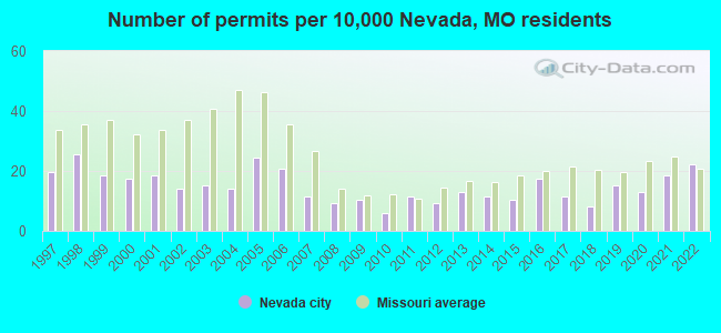
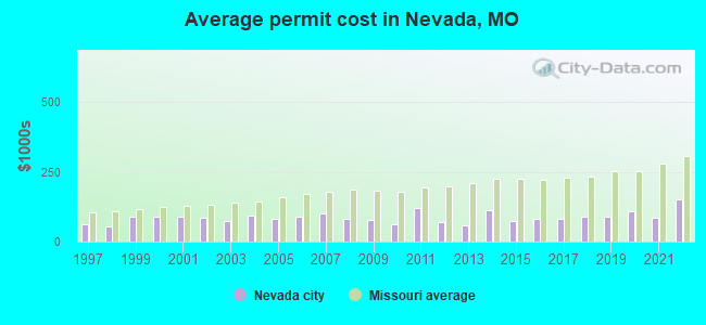
Single-family new house construction building permits:
- 2022: 19 buildings, average cost: $149,500
- 2021: 16 buildings, average cost: $83,600
- 2020: 11 buildings, average cost: $109,900
- 2019: 13 buildings, average cost: $89,200
- 2018: 7 buildings, average cost: $90,000
- 2017: 10 buildings, average cost: $80,600
- 2016: 15 buildings, average cost: $82,700
- 2015: 9 buildings, average cost: $73,300
- 2014: 10 buildings, average cost: $111,600
- 2013: 11 buildings, average cost: $58,400
- 2012: 8 buildings, average cost: $70,400
- 2011: 10 buildings, average cost: $120,400
- 2010: 5 buildings, average cost: $63,000
- 2009: 9 buildings, average cost: $78,700
- 2008: 8 buildings, average cost: $79,600
- 2007: 10 buildings, average cost: $99,800
- 2006: 18 buildings, average cost: $88,100
- 2005: 21 buildings, average cost: $80,200
- 2004: 12 buildings, average cost: $92,500
- 2003: 13 buildings, average cost: $73,400
- 2002: 12 buildings, average cost: $87,300
- 2001: 16 buildings, average cost: $87,900
- 2000: 15 buildings, average cost: $87,900
- 1999: 16 buildings, average cost: $87,900
- 1998: 22 buildings, average cost: $54,500
- 1997: 17 buildings, average cost: $62,600
| Here: | 3.1% |
| Missouri: | 2.8% |
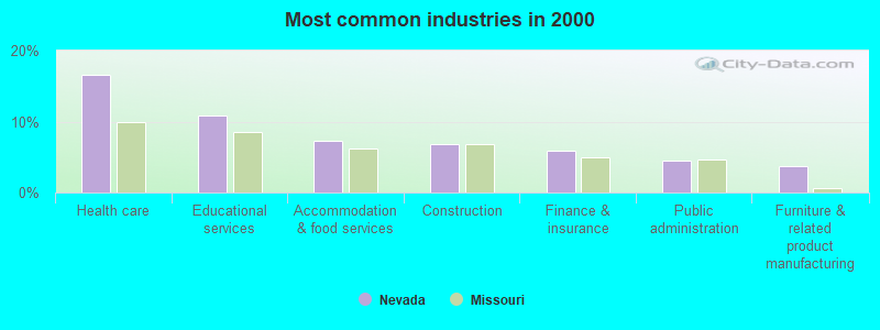
- Health care (16.6%)
- Educational services (10.8%)
- Accommodation & food services (7.3%)
- Construction (6.8%)
- Finance & insurance (5.9%)
- Public administration (4.4%)
- Furniture & related product manufacturing (3.7%)
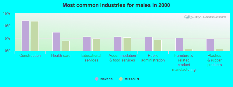
- Construction (12.2%)
- Health care (7.4%)
- Educational services (5.7%)
- Accommodation & food services (5.6%)
- Public administration (5.5%)
- Furniture & related product manufacturing (5.1%)
- Plastics & rubber products (4.8%)
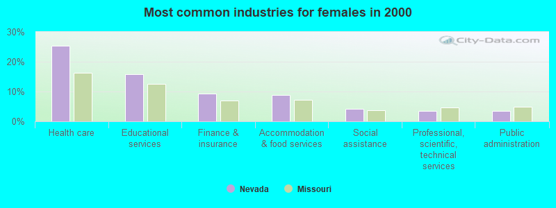
- Health care (25.4%)
- Educational services (15.7%)
- Finance & insurance (9.3%)
- Accommodation & food services (8.8%)
- Social assistance (4.2%)
- Professional, scientific, technical services (3.4%)
- Public administration (3.4%)
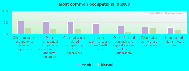
- Other production occupations, including supervisors (5.6%)
- Other management occupations, except farmers and farm managers (5.5%)
- Other sales and related occupations, including supervisors (5.0%)
- Nursing, psychiatric, and home health aides (4.5%)
- Other office and administrative support workers, including supervisors (3.5%)
- Driver/sales workers and truck drivers (3.1%)
- Laborers and material movers, hand (2.8%)
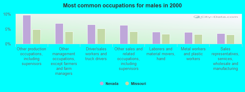
- Other production occupations, including supervisors (9.7%)
- Other management occupations, except farmers and farm managers (6.9%)
- Driver/sales workers and truck drivers (6.4%)
- Other sales and related occupations, including supervisors (6.3%)
- Laborers and material movers, hand (4.0%)
- Metal workers and plastic workers (3.9%)
- Sales representatives, services, wholesale and manufacturing (3.5%)
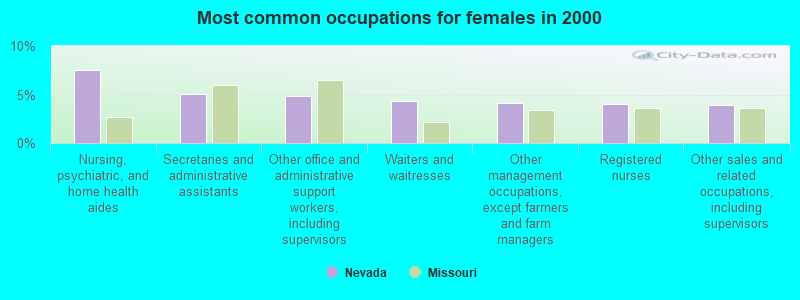
- Nursing, psychiatric, and home health aides (7.5%)
- Secretaries and administrative assistants (5.0%)
- Other office and administrative support workers, including supervisors (4.9%)
- Waiters and waitresses (4.4%)
- Other management occupations, except farmers and farm managers (4.1%)
- Registered nurses (4.0%)
- Other sales and related occupations, including supervisors (3.9%)
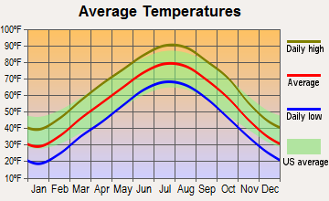
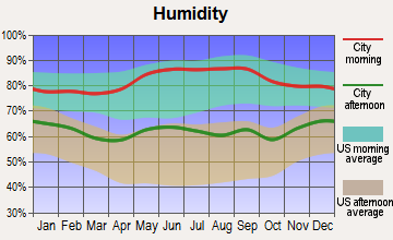
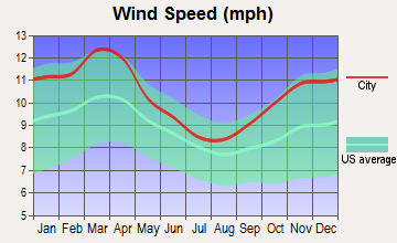
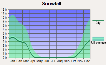
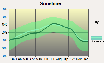
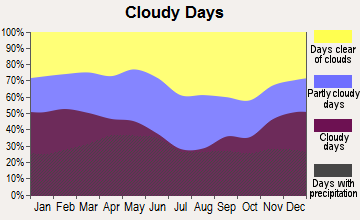
Average climate in Nevada, Missouri
Based on data reported by over 4,000 weather stations

|
|


(lower is better)
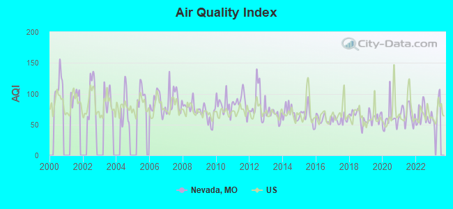
Air Quality Index (AQI) level in 2022 was 64.4. This is about average.
| City: | 64.4 |
| U.S.: | 72.6 |
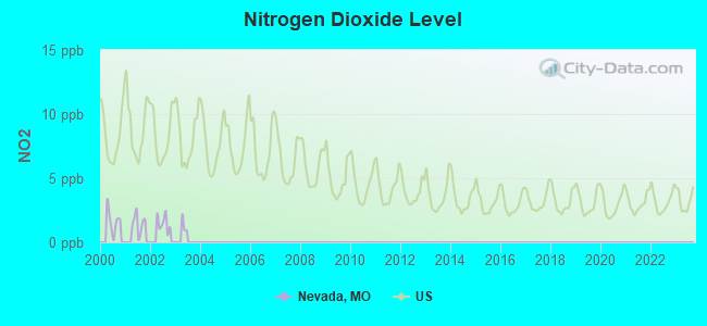
Nitrogen Dioxide (NO2) [ppb] level in 2002 was 1.49. This is significantly better than average. Closest monitor was 20.0 miles away from the city center.
| City: | 1.49 |
| U.S.: | 5.11 |
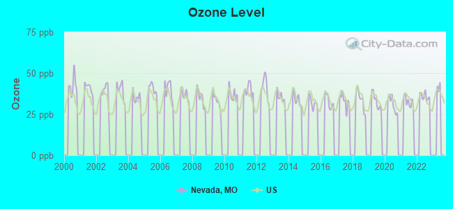
Ozone [ppb] level in 2022 was 36.1. This is about average. Closest monitor was 20.0 miles away from the city center.
| City: | 36.1 |
| U.S.: | 33.3 |
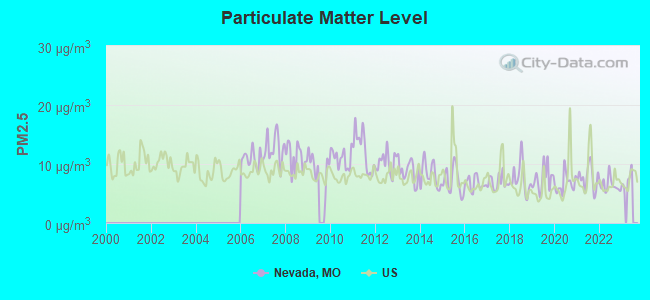
Particulate Matter (PM2.5) [µg/m3] level in 2022 was 6.44. This is better than average. Closest monitor was 20.0 miles away from the city center.
| City: | 6.44 |
| U.S.: | 8.11 |
Tornado activity:
Nevada-area historical tornado activity is near Missouri state average. It is 62% greater than the overall U.S. average.
On 5/4/2003, a category F4 (max. wind speeds 207-260 mph) tornado 20.4 miles away from the Nevada city center killed 4 people and injured 30 people and caused $20 million in damages.
On 5/17/1995, a category F3 (max. wind speeds 158-206 mph) tornado 6.3 miles away from the city center injured 9 people and caused between $5,000,000 and $50,000,000 in damages.
Earthquake activity:
Nevada-area historical earthquake activity is significantly above Missouri state average. It is 593% greater than the overall U.S. average.On 9/3/2016 at 12:02:44, a magnitude 5.8 (5.8 MW, Depth: 3.5 mi, Class: Moderate, Intensity: VI - VII) earthquake occurred 172.4 miles away from the city center
On 11/6/2011 at 03:53:10, a magnitude 5.7 (5.7 MW, Depth: 3.2 mi) earthquake occurred 208.2 miles away from Nevada center
On 11/7/2016 at 01:44:24, a magnitude 5.0 (5.0 MW, Depth: 2.8 mi) earthquake occurred 186.3 miles away from Nevada center
On 11/12/2014 at 21:40:00, a magnitude 4.9 (4.9 MW, Depth: 2.5 mi, Class: Light, Intensity: IV - V) earthquake occurred 183.3 miles away from Nevada center
On 2/13/2016 at 17:07:06, a magnitude 5.1 (5.1 MW, Depth: 5.2 mi) earthquake occurred 257.5 miles away from Nevada center
On 11/5/2011 at 07:12:45, a magnitude 4.8 (4.8 MW, Depth: 1.9 mi) earthquake occurred 207.2 miles away from Nevada center
Magnitude types: moment magnitude (MW)
Natural disasters:
The number of natural disasters in Vernon County (21) is greater than the US average (15).Major Disasters (Presidential) Declared: 13
Emergencies Declared: 6
Causes of natural disasters: Storms: 13, Floods: 12, Tornadoes: 9, Winter Storms: 4, Drought: 1, Hurricane: 1, Ice Storm: 1, Snowstorm: 1, Wind: 1, Other: 1 (Note: some incidents may be assigned to more than one category).

Hospitals and medical centers in Nevada:
- HEARTLAND BEHAVORIAL HEALTH SERVICES (1500 WEST ASHLAND)
- NEVADA REGIONAL MEDICAL CENTER (Government - Local, 800 S ASH ST)
- NEVADA STATE HOSPITAL (ASH STREET AT HIGHLAND)
- NEVADA REGIONAL MEDICAL CENTER HOME HEALTH AGENCY (800 SOUTH ASH)
- CHRISTIAN HEALTH AND REHABILITATION OF NEVADA (700 EAST HIGHLAND AVENUE)
- MEDICALODGES NEVADA (1210 WEST ASHLAND)
- MOORE-FEW CARE CENTER (901 SOUTH ADAMS)
- PAUL L AND MARTHA BARONE CARE CENTER (2102 NORTH ASH STREET)
Airports and heliports located in Nevada:
- Nevada Municipal Airport (NVD) (Runways: 2, Air Taxi Ops: 60, Itinerant Ops: 1,700, Local Ops: 1,080, Military Ops: 50)
- Camp Clark Ahp Heliport (35MO)
- Nevada Regional Medical Center Heliport (MO20)
Colleges/Universities in Nevada:
Colleges/universities with over 2000 students nearest to Nevada:
- Pittsburg State University (about 37 miles; Pittsburg, KS; Full-time enrollment: 6,838)
- Missouri Southern State University (about 52 miles; Joplin, MO; FT enrollment: 4,456)
- Southwest Baptist University (about 55 miles; Bolivar, MO; FT enrollment: 2,783)
- Allen County Community College (about 58 miles; Iola, KS; FT enrollment: 2,089)
- Crowder College (about 72 miles; Neosho, MO; FT enrollment: 3,675)
- University of Central Missouri (about 72 miles; Warrensburg, MO; FT enrollment: 9,952)
- Northeastern Oklahoma A&M College (about 73 miles; Miami, OK; FT enrollment: 2,075)
Public high schools in Nevada:
- NEVADA HIGH (Students: 796, Location: 800 W HICKORY ST, Grades: 9-12)
- HEARTLAND R-V SCH. (Students: 44, Location: 1500 W ASHLAND, Grades: 2-12)
- CEDAR RIDGE SCHOOL (Location: 901 N OLIVE ST, Grades: KG-12)
- NEVADA REGIONAL TECH.-CTR. (Location: 900 W ASHLAND ST, Grades: 9-12)
Public elementary/middle schools in Nevada:
- TRUMAN ELEM. (Students: 588, Location: 901 W ASHLAND, Grades: 3-5)
- NEVADA MIDDLE (Students: 578, Location: 900 N OLIVE ST, Grades: 6-8)
- BENTON ELEM. (Students: 180, Location: 500 E VERNON ST, Grades: 2)
- BRYAN ELEM. (Location: 400 W LEE ST, Grades: PK-1)
Private elementary/middle schools in Nevada:
Points of interest:
Notable locations in Nevada: Nevada Country Club (A), Nevada Fire Department (B). Display/hide their locations on the map
Churches in Nevada include: First Christian Church (A), United Methodist Church (B), First Baptist Church (C), Heritage Baptist Church (D), Countryside Assembly of God Church (E). Display/hide their locations on the map
Cemeteries: Deepwood Cemetery (1), Nevada State Hospital Cemetery (2), Newton Cemetery (3), Callaway Cemetery (4), Mount Calvary Cemetery (5). Display/hide their locations on the map
Reservoir: Katy Allen Lake (A). Display/hide its location on the map
Streams, rivers, and creeks: Willow Branch (A). Display/hide its location on the map
Parks in Nevada include: Marmaduke Park (1), George Lyons Park (2), Walton Park (3), Centennial Park (4), Radio Springs Park (5), Spring Street Park (6), Postlethwaite Park (7), Twin Lakes Park (8). Display/hide their locations on the map
Tourist attractions: Bushwhacker - Museum (212 West Walnut Street), Bushwhacker - Jail (Museums; 231 North Main Street).
Hotels: Days Inn Nevada MO (2345 East Marvel Road), Country Inn-Suites Nevada (2520 East Austin), Comfort Inn (2345 E Marvel Rd), Econo Lodge Nevada (1401 East Austin Boulevard), Best Western Rambler Motel (1401 East Austin Boulevard), Country Inn & Suites by Carlson-Nevada (2520 East Austin Boulevard).
Courts: Vernon - County - Bridge Department- Custodian- Highway Barn- Courthouse- Bridge Depart (200 North Colorado), Vernon - County - Courthouse- Custodian (Court House Custodia), Vernon County - Custodian- Clerk's Ofc (Courthouse), Vernon County - Court House- Jail- Custodian (230 West Cherry Street).
Birthplace of: John Huston - (1906-1987), film director, Ralph Eberhart - General, Sue Thompson - Country singer, Harry J. Lloyd - Businessman, Eva Bowring - Politician, Patricia Breckenridge - Politician, Virginia Dehn - Painter.
| This city: | 2.2 people |
| Missouri: | 2.5 people |
| This city: | 54.7% |
| Whole state: | 65.3% |
| This city: | 6.9% |
| Whole state: | 6.7% |
Likely homosexual households (counted as self-reported same-sex unmarried-partner households)
- Lesbian couples: 0.1% of all households
- Gay men: 0.2% of all households
People in group quarters in Nevada in 2010:
- 286 people in college/university student housing
- 263 people in nursing facilities/skilled-nursing facilities
- 105 people in residential treatment centers for adults
- 95 people in residential treatment centers for juveniles (non-correctional)
- 48 people in local jails and other municipal confinement facilities
- 22 people in group homes for juveniles (non-correctional)
- 10 people in other noninstitutional facilities
- 7 people in group homes intended for adults
People in group quarters in Nevada in 2000:
- 337 people in nursing homes
- 251 people in college dormitories (includes college quarters off campus)
- 152 people in schools, hospitals, or wards for the intellectually disabled
- 123 people in mental (psychiatric) hospitals or wards
- 35 people in homes for the mentally retarded
- 12 people in local jails and other confinement facilities (including police lockups)
- 5 people in other noninstitutional group quarters
Banks with branches in Nevada (2011 data):
- Metz Banking Company: at 123 North Osage Boulevard, branch established on 1906/09/14. Info updated 2006/11/03: Bank assets: $64.2 mil, Deposits: $57.5 mil, local headquarters, positive income, Agricultural Specialization, 2 total offices
- Bank of America, National Association: Nevada Branch at 401 E. Austin Branch, branch established on 1869/06/19. Info updated 2009/11/18: Bank assets: $1,451,969.3 mil, Deposits: $1,077,176.8 mil, headquarters in Charlotte, NC, positive income, 5782 total offices, Holding Company: Bank Of America Corporation
- Great Southern Bank: Nevada Branch at 201 East Cherry Street, branch established on 1928/01/02. Info updated 2012/02/03: Bank assets: $3,788.7 mil, Deposits: $2,986.3 mil, headquarters in Reeds Spring, MO, positive income, Commercial Lending Specialization, 109 total offices, Holding Company: Great Southern Bancorp, Inc.
- The First National Bank of Nevada, Missouri: The First National Bank Of Nevada, Missouri at 100 W. Walnut St, branch established on 1889/01/01. Info updated 2010/06/01: Bank assets: $88.9 mil, Deposits: $76.3 mil, local headquarters, positive income, Agricultural Specialization, 1 total offices, Holding Company: 1889 Bancshares, Inc.
- Heritage State Bank: at 1625 Hedges Plaza, branch established on 1911/06/11. Info updated 2006/11/03: Bank assets: $117.1 mil, Deposits: $93.5 mil, local headquarters, positive income, Agricultural Specialization, 5 total offices, Holding Company: Shelbank Corporation
- U.S. Bank National Association: Nevada Branch at 200 East Cherry, branch established on 1997/11/14. Info updated 2012/01/30: Bank assets: $330,470.8 mil, Deposits: $236,091.5 mil, headquarters in Cincinnati, OH, positive income, 3121 total offices, Holding Company: U.S. Bancorp
For population 15 years and over in Nevada:
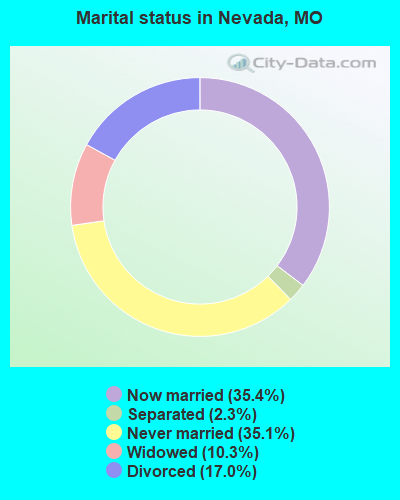
- Never married: 35.1%
- Now married: 35.4%
- Separated: 2.3%
- Widowed: 10.3%
- Divorced: 17.0%
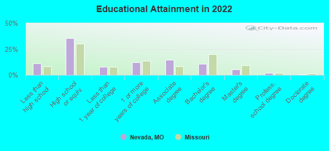
For population 25 years and over in Nevada:
- High school or higher: 88.7%
- Bachelor's degree or higher: 18.1%
- Graduate or professional degree: 7.6%
- Unemployed: 6.0%
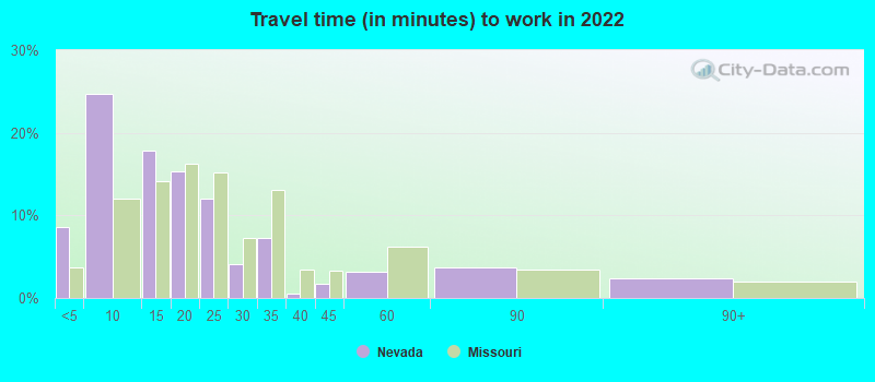
- Mean travel time to work (commute): 14.8 minutes
| Here: | 10.8 |
| Missouri average: | 11.1 |
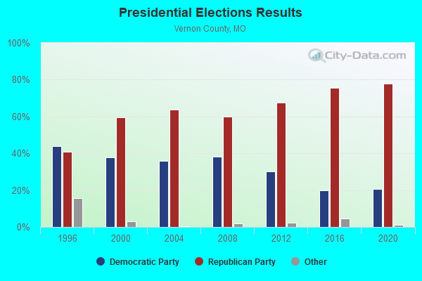
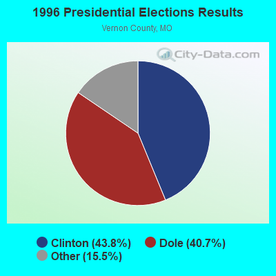
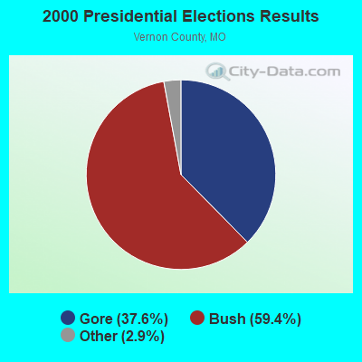
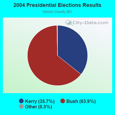
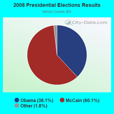
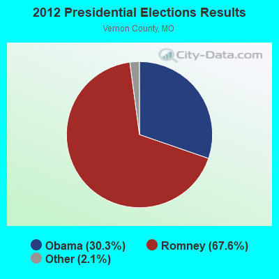
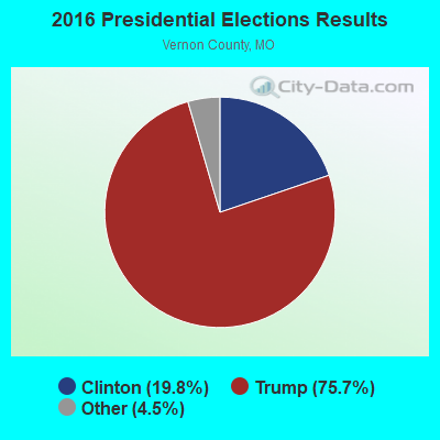
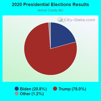
Graphs represent county-level data. Detailed 2008 Election Results
Religion statistics for Nevada, MO (based on Vernon County data)
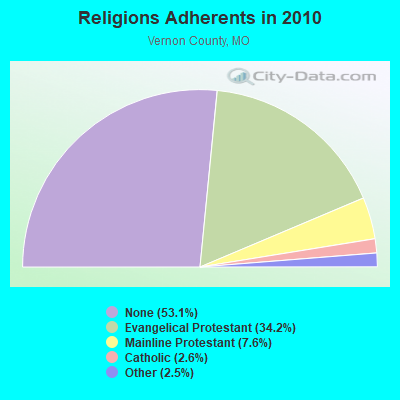
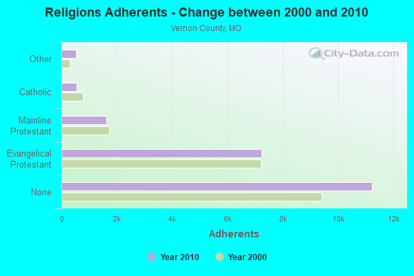
| Religion | Adherents | Congregations |
|---|---|---|
| Evangelical Protestant | 7,240 | 36 |
| Mainline Protestant | 1,618 | 11 |
| Catholic | 542 | 2 |
| Other | 522 | 3 |
| None | 11,237 | - |
Food Environment Statistics:
| Vernon County: | 1.00 / 10,000 pop. |
| Missouri: | 1.88 / 10,000 pop. |
| This county: | 0.50 / 10,000 pop. |
| Missouri: | 0.18 / 10,000 pop. |
| Vernon County: | 5.00 / 10,000 pop. |
| Missouri: | 4.34 / 10,000 pop. |
| This county: | 7.50 / 10,000 pop. |
| Missouri: | 7.37 / 10,000 pop. |
| Vernon County: | 9.5% |
| Missouri: | 8.8% |
| This county: | 29.7% |
| Missouri: | 29.6% |
| Vernon County: | 13.5% |
| Missouri: | 13.5% |
Health and Nutrition:
| Here: | 50.8% |
| State: | 50.9% |
| Nevada: | 48.3% |
| Missouri: | 48.6% |
| This city: | 28.9 |
| Missouri: | 28.7 |
| Nevada: | 18.9% |
| Missouri: | 20.6% |
| Nevada: | 10.0% |
| Missouri: | 10.1% |
| Nevada: | 6.9 |
| Missouri: | 6.8 |
| Nevada: | 34.7% |
| Missouri: | 34.3% |
| Nevada: | 57.9% |
| Missouri: | 57.5% |
| Nevada: | 78.0% |
| State: | 79.3% |
More about Health and Nutrition of Nevada, MO Residents
| Local government employment and payroll (March 2022) | |||||
| Function | Full-time employees | Monthly full-time payroll | Average yearly full-time wage | Part-time employees | Monthly part-time payroll |
|---|---|---|---|---|---|
| Hospitals | 352 | $1,868,116 | $63,686 | 76 | $167,812 |
| Police Protection - Officers | 5 | $18,587 | $44,609 | 0 | $0 |
| Other and Unallocable | 3 | $9,101 | $36,404 | 1 | $359 |
| Firefighters | 3 | $12,140 | $48,560 | 0 | $0 |
| Parks and Recreation | 2 | $5,268 | $31,608 | 3 | $2,770 |
| Solid Waste Management | 1 | $774 | $9,288 | 0 | $0 |
| Water Supply | 1 | $2,673 | $32,076 | 0 | $0 |
| Other Government Administration | 1 | $4,879 | $58,548 | 0 | $0 |
| Financial Administration | 1 | $4,438 | $53,256 | 0 | $0 |
| Sewerage | 1 | $3,307 | $39,684 | 0 | $0 |
| Streets and Highways | 1 | $3,446 | $41,352 | 0 | $0 |
| Police - Other | 1 | $2,817 | $33,804 | 0 | $0 |
| Judicial and Legal | 0 | $0 | 1 | $4,059 | |
| Totals for Government | 372 | $1,935,546 | $62,437 | 81 | $175,000 |
Nevada government finances - Expenditure in 2021 (per resident):
- Construction - Water Utilities: $336,000 ($40.95)
Sewerage: $197,000 ($24.01)
- Current Operations - Hospitals: $37,766,000 ($4602.80)
Police Protection: $2,795,000 ($340.65)
Water Utilities: $1,989,000 ($242.41)
Sewerage: $1,209,000 ($147.35)
Parks and Recreation: $1,141,000 ($139.06)
Regular Highways: $927,000 ($112.98)
Central Staff Services: $715,000 ($87.14)
Financial Administration: $600,000 ($73.13)
Health - Other: $151,000 ($18.40)
General Public Buildings: $135,000 ($16.45)
General - Other: $111,000 ($13.53)
Air Transportation: $13,000 ($1.58)
- General - Interest on Debt: $3,024,000 ($368.56)
- Other Capital Outlay - General - Other: $1,215,000 ($148.08)
Regular Highways: $576,000 ($70.20)
Parks and Recreation: $100,000 ($12.19)
- Total Salaries and Wages: $20,726,000 ($2526.02)
Nevada government finances - Revenue in 2021 (per resident):
- Charges - Hospital Public: $37,031,000 ($4513.22)
Other: $8,199,000 ($999.27)
Sewerage: $1,628,000 ($198.42)
Parks and Recreation: $306,000 ($37.29)
- Miscellaneous - General Revenue - Other: $30,644,000 ($3734.80)
Interest Earnings: $1,980,000 ($241.32)
Fines and Forfeits: $101,000 ($12.31)
Sale of Property: $43,000 ($5.24)
- Revenue - Water Utilities: $2,767,000 ($337.23)
- State Intergovernmental - General Local Government Support: $116,000 ($14.14)
Other: $1,000 ($0.12)
- Tax - Property: $5,677,000 ($691.90)
General Sales and Gross Receipts: $854,000 ($104.08)
Other License: $97,000 ($11.82)
Nevada government finances - Debt in 2021 (per resident):
- Long Term Debt - Beginning Outstanding - Unspecified Public Purpose: $47,119,000 ($5742.72)
Outstanding Unspecified Public Purpose: $45,356,000 ($5527.85)
Beginning Outstanding - Public Debt for Private Purpose: $30,000,000 ($3656.31)
Outstanding Nonguaranteed - Industrial Revenue: $28,000,000 ($3412.55)
Retired Nonguaranteed - Public Debt for Private Purpose: $2,000,000 ($243.75)
Retired Unspecified Public Purpose: $1,763,000 ($214.87)
Nevada government finances - Cash and Securities in 2021 (per resident):
- Other Funds - Cash and Securities: $17,346,000 ($2114.08)
- Sinking Funds - Cash and Securities: $34,678,000 ($4226.45)
| Businesses in Nevada, MO | ||||
| Name | Count | Name | Count | |
|---|---|---|---|---|
| AT&T | 1 | McDonald's | 1 | |
| AutoZone | 1 | Pizza Hut | 1 | |
| Burger King | 1 | RadioShack | 1 | |
| Chevrolet | 1 | SAS Shoes | 1 | |
| Dairy Queen | 1 | SONIC Drive-In | 1 | |
| Domino's Pizza | 1 | Sears | 1 | |
| FedEx | 2 | Subway | 1 | |
| Ford | 1 | Super 8 | 1 | |
| H&R Block | 1 | Taco Bell | 1 | |
| Hardee's | 1 | U-Haul | 2 | |
| KFC | 1 | UPS | 2 | |
| La-Z-Boy | 1 | Walmart | 1 | |
| Lane Furniture | 1 | YMCA | 1 | |
| MasterBrand Cabinets | 3 | |||
Strongest AM radio stations in Nevada:
- KNEM (1240 AM; 0 kW; NEVADA, MO; Owner: HARBIT COMMUNICATIONS, INC)
- KKOW (860 AM; 10 kW; PITTSBURG, KS; Owner: AMERICAN MEDIA INVESTMENTS)
- WHB (810 AM; 50 kW; KANSAS CITY, MO; Owner: UNION BROADCASTING, INC.)
- KRMG (740 AM; 50 kW; TULSA, OK; Owner: CXR HOLDINGS, INC.)
- KKHK (1250 AM; 25 kW; KANSAS CITY, KS)
- KGGF (690 AM; 10 kW; COFFEYVILLE, KS; Owner: KGGF-KUSN, INC.)
- WMBH (1560 AM; 10 kW; JOPLIN, MO)
- KFAQ (1170 AM; 50 kW; TULSA, OK; Owner: JOURNAL BROADCAST CORPORATION)
- KKLL (1100 AM; daytime; 5 kW; WEBB CITY, MO; Owner: NEW LIFE EVANGELISTIC CENTER, INC.)
- KBTN (1420 AM; 10 kW; NEOSHO, MO; Owner: PETRACOM OF JOPLIN, L.L.C.)
- KOCR (1310 AM; 5 kW; JOPLIN, MO; Owner: OZARK CHRISTIAN COLLEGE)
- KCMO (710 AM; 10 kW; KANSAS CITY, MO; Owner: SUSQUEHANNA KANSAS CITY PARTNERSHIP)
- KCSP (610 AM; 5 kW; KANSAS CITY, MO; Owner: ENTERCOM KANSAS CITY LICENSE, LLC)
Strongest FM radio stations in Nevada:
- K206CH (89.1 FM; NEVADA, MO; Owner: CALVARY CHAPEL OF TWIN FALLS, INC.)
- KNMO-FM (97.5 FM; NEVADA, MO; Owner: HARBIT COMMUNICATIONS, INC)
- KVCY (104.7 FM; FORT SCOTT, KS; Owner: VCY AMERICA, INC.)
- KOMB (103.9 FM; FORT SCOTT, KS; Owner: FORT SCOTT BROADCCASTING CO., INC.)
- KBZI (100.7 FM; DEERFIELD, MO; Owner: AMERICAN MEDIA INVESTMENTS INC)
- KRPS (89.9 FM; PITTSBURG, KS; Owner: PITTSBURG STATE UNIVERSITY)
- KKOW-FM (96.9 FM; PITTSBURG, KS; Owner: AMERICAN MEDIA INVESTMENTS, INC.)
- KESM-FM (105.5 FM; EL DORADO SPRINGS, MO; Owner: WILDWOOD COMMUNICATIONS, INC.)
TV broadcast stations around Nevada:
- KOAM-TV (Channel 7; PITTSBURG, KS; Owner: SAGA QUAD STATES COMMUNICATIONS, LLC)
- National Bridge Inventory (NBI) Statistics
- 85Number of bridges
- 833ft / 254mTotal length
- $11,903,000Total costs
- 171,526Total average daily traffic
- 51,540Total average daily truck traffic
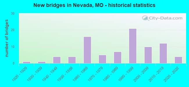
- New bridges - historical statistics
- 11920-1929
- 11930-1939
- 41940-1949
- 41950-1959
- 161960-1969
- 51970-1979
- 71980-1989
- 211990-1999
- 102000-2009
- 122010-2019
- 42020-2022
FCC Registered Antenna Towers: 165 (See the full list of FCC Registered Antenna Towers)
FCC Registered Broadcast Land Mobile Towers: 32 (See the full list of FCC Registered Broadcast Land Mobile Towers in Nevada, MO)
FCC Registered Microwave Towers: 26 (See the full list of FCC Registered Microwave Towers in this town)
FCC Registered Paging Towers: 6 (See the full list of FCC Registered Paging Towers)
FCC Registered Maritime Coast & Aviation Ground Towers: 3 (See the full list of FCC Registered Maritime Coast & Aviation Ground Towers)
FCC Registered Amateur Radio Licenses: 55 (See the full list of FCC Registered Amateur Radio Licenses in Nevada)
FAA Registered Aircraft: 15 (See the full list of FAA Registered Aircraft in Nevada)
2002 - 2018 National Fire Incident Reporting System (NFIRS) incidents
- Fire incident types reported to NFIRS in Nevada, MO
- 50542.3%Structure Fires
- 49441.4%Outside Fires
- 18115.2%Mobile Property/Vehicle Fires
- 141.2%Other
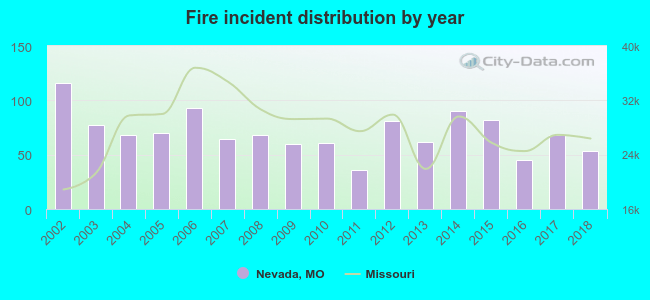 According to the data from the years 2002 - 2018 the average number of fires per year is 70. The highest number of fire incidents - 116 took place in 2002, and the least - 36 in 2011. The data has a declining trend.
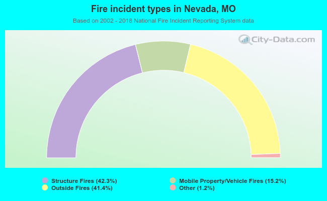 When looking into fire subcategories, the most incidents belonged to: Structure Fires (42.3%), and Outside Fires (41.4%).
Fire-safe hotels and motels in Nevada, Missouri:
- Super 8 Motel, PO Box 529, Nevada, Missouri 64772 , Phone: (417) 667-8880, Fax: (417) 667-8883
- Americas Best Value Inn & Suites, 2345 E Marvel Rd, Nevada, Missouri 64772 , Phone: (417) 667-6777, Fax: (417) 667-6135
- Country Inn & Suites By Carlson - Nevada, Mo, 2520 E Austin, Nevada, Missouri 64772 , Phone: (417) 667-9292, Fax: (417) 667-2186
- Holiday Inn Express & Suites, 311 S Johnson Dr, Nevada, Missouri 64772 , Phone: (417) 283-6177, Fax: (417) 283-6188
| Most common first names in Nevada, MO among deceased individuals | ||
| Name | Count | Lived (average) |
|---|---|---|
| Mary | 160 | 79.9 years |
| William | 125 | 74.7 years |
| John | 114 | 76.6 years |
| James | 106 | 72.6 years |
| Charles | 89 | 73.1 years |
| Robert | 88 | 70.8 years |
| George | 82 | 75.9 years |
| Helen | 63 | 75.8 years |
| Ruth | 56 | 80.2 years |
| Harry | 51 | 79.2 years |
| Most common last names in Nevada, MO among deceased individuals | ||
| Last name | Count | Lived (average) |
|---|---|---|
| Smith | 94 | 75.5 years |
| Johnson | 53 | 76.4 years |
| Jones | 39 | 76.5 years |
| Davis | 39 | 79.8 years |
| Williams | 38 | 73.9 years |
| Thomas | 34 | 76.5 years |
| Brown | 33 | 75.7 years |
| Miller | 32 | 79.8 years |
| Wilson | 28 | 78.7 years |
| Moore | 27 | 79.5 years |
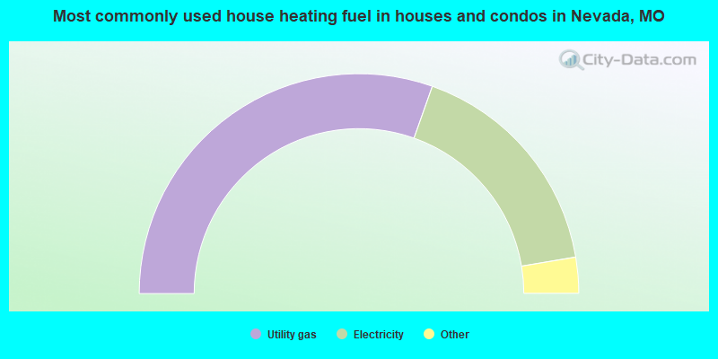
- 60.9%Utility gas
- 33.9%Electricity
- 3.1%Wood
- 2.1%Bottled, tank, or LP gas
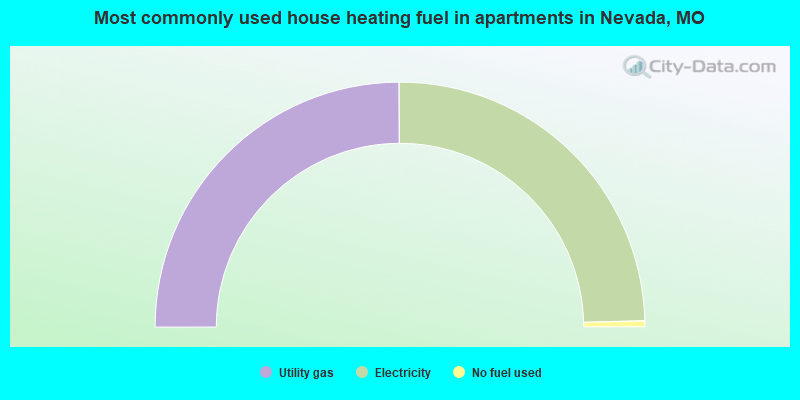
- 49.9%Utility gas
- 49.3%Electricity
- 0.8%No fuel used
Nevada compared to Missouri state average:
- Median house value below state average.
- Unemployed percentage below state average.
- Black race population percentage significantly below state average.
- Median age above state average.
- Foreign-born population percentage significantly below state average.
- Renting percentage above state average.
- Length of stay since moving in above state average.
- House age above state average.
- Institutionalized population percentage above state average.
Nevada on our top lists:
- #14 on the list of "Top 101 cities with largest percentage of males in industries: health care and social assistance (population 5,000+)"
- #30 on the list of "Top 101 cities with the highest number of thefts per 100,000 residents, excludes tourist destinations and others with a lot of outsiders visiting based on city industries data (population 5,000+)"
- #35 on the list of "Top 101 cities with the largest percentage of people in schools, hospitals, or wards for the mentally retarded (population 1,000+)"
- #36 on the list of "Top 101 cities with largest percentage of males in occupations: healthcare support occupations (population 5,000+)"
- #49 on the list of "Top 101 cities with the largest percentage of people in mental (psychiatric) hospitals or wards (population 1,000+)"
- #78 on the list of "Top 101 cities with largest percentage of females in industries: health care and social assistance (population 5,000+)"

|
Total of 6 patent applications in 2008-2024.