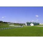
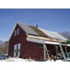
New Gloucester, Maine
Submit your own pictures of this town and show them to the world
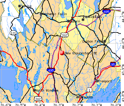
- OSM Map
- General Map
- Google Map
- MSN Map
Population change since 2000: +15.4%
 |
| Males: 2,823 | |
| Females: 2,719 |
| Median resident age: | 39.5 years |
| Maine median age: | 43.0 years |
Zip codes: 04260.
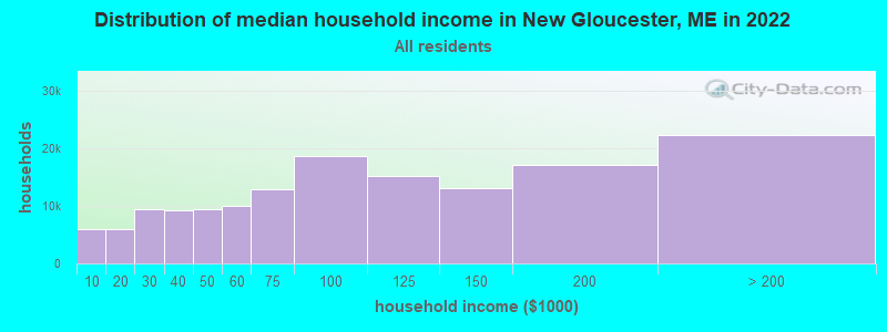
| New Gloucester: | $100,604 |
| ME: | $69,543 |
Estimated per capita income in 2022: $44,901 (it was $19,527 in 2000)
New Gloucester town income, earnings, and wages data
Estimated median house or condo value in 2022: $398,343 (it was $116,900 in 2000)
| New Gloucester: | $398,343 |
| ME: | $290,600 |
Mean prices in 2022: all housing units: $514,200; detached houses: $533,395; townhouses or other attached units: $572,947; in 2-unit structures: $538,406; in 3-to-4-unit structures: $462,507; in 5-or-more-unit structures: $450,834; mobile homes: $93,551
New Gloucester, ME residents, houses, and apartments details
Detailed information about poverty and poor residents in New Gloucester, ME

Compare current foreclosures near New Gloucester, ME:
| Photo | Address | Area | Beds / Baths | Price | Details |
|---|---|---|---|---|---|

|
#1
Hale Rd
Raymond, ME 04071
|
2,808 sq. feet
|
2 baths 3 beds |
$474,900
|
show details |

|
#2
Motorcycle Dr
Windham, ME 04062
|
2,772 sq. feet
|
2 baths 3 beds |
show details | |

|
#3
Jillson Rd
Greene, ME 04236
|
1,356 sq. feet
|
1 baths 4 beds |
show details | |

|
#4
High St
Windham, ME 04062
|
933 sq. feet
|
1 baths 2 beds |
show details | |

|
#5
Spring St
Lisbon, ME 04250
|
1,141 sq. feet
|
1 baths 3 beds |
show details | |

|
#6
Western Promenade
Auburn, ME 04210
|
2,908 sq. feet
|
3 baths 5 beds |
show details | |

|
#7
Pleasant St
Lisbon Falls, ME 04252
|
561 sq. feet
|
1 baths 2 beds |
show details | |

|
#8
Nottingham Rd
Auburn, ME 04210
|
1,692 sq. feet
|
2 baths 2 beds |
show details | |

|
#9
Ring Landing Rd
Casco, ME 04015
|
1,296 sq. feet
|
1 baths 3 beds |
show details | |

|
#10
Main St
Lewiston, ME 04240
|
- sq. feet
|
1 baths 3 beds |
show details |
| Photo | Address | Area | Beds / Baths | Price | Details |
|---|---|---|---|---|---|

|
#11
Cottage Rd
Windham, ME 04062
|
1,404 sq. feet
|
1 baths 2 beds |
show details | |

|
#12
Running Brook Rd
Windham, ME 04062
|
1,749 sq. feet
|
2 baths 3 beds |
show details | |

|
#13
Bruce Hill Rd
Cumberland Center, ME 04021
|
2,536 sq. feet
|
2 baths 3 beds |
show details | |

|
#14
Pownal Rd
Auburn, ME 04210
|
1,099 sq. feet
|
1 baths 2 beds |
show details | |

|
#15
Majestic Hts
Windham, ME 04062
|
1,668 sq. feet
|
2 baths 3 beds |
show details | |

|
#16
Windham Center Rd
Windham, ME 04062
|
1,576 sq. feet
|
1 baths 3 beds |
show details | |

|
#17
Stevens Mill Rd
Auburn, ME 04210
|
1,547 sq. feet
|
2 baths 4 beds |
show details | |

|
#18
Anita Ave
Auburn, ME 04210
|
2,016 sq. feet
|
1 baths 3 beds |
show details | |

|
#19
Minot Ave
Auburn, ME 04210
|
1,444 sq. feet
|
1 baths 3 beds |
show details | |

|
#20
Emerson Dr
Windham, ME 04062
|
1,080 sq. feet
|
1 baths 3 beds |
show details |
| Photo | Address | Area | Beds / Baths | Price | Details |
|---|---|---|---|---|---|

|
#21
Xivray St
Auburn, ME 04210
|
2,632 sq. feet
|
1 baths - beds |
show details | |

|
#22
River View Dr
Oxford, ME 04270
|
- sq. feet
|
- baths - beds |
show details | |

|
#23
Chase Ct
Freeport, ME 04032
|
- sq. feet
|
- baths - beds |
show details | |

|
#24
Winter St Apt 2
Topsham, ME 04086
|
- sq. feet
|
- baths - beds |
show details | |

|
#25
Yarmouth Rd
Gray, ME 04039
|
- sq. feet
|
- baths - beds |
show details | |

|
#26
Spring St Apt 2
Lewiston, ME 04240
|
- sq. feet
|
- baths - beds |
show details | |

|
#27
Sabattus Creek Dr
Lisbon, ME 04250
|
- sq. feet
|
- baths - beds |
show details | |

|
#28
Bartlett St
Lewiston, ME 04240
|
- sq. feet
|
- baths - beds |
show details | |

|
#29
Stone Brook Rd
Mechanic Falls, ME 04256
|
- sq. feet
|
- baths - beds |
show details | |

|
#30
Durham Rd
Freeport, ME 04032
|
- sq. feet
|
- baths - beds |
show details |
| Photo | Address | Area | Beds / Baths | Price | Details |
|---|---|---|---|---|---|

|
#31
Gray Rd
Cumberland Center, ME 04021
|
- sq. feet
|
- baths - beds |
show details | |

|
#32
Riverside Dr # 650
Auburn, ME 04210
|
- sq. feet
|
- baths - beds |
show details | |

|
#33
Belmont Ct, Unit 8
Auburn, ME 04210
|
- sq. feet
|
- baths - beds |
show details | |

|
#34
Lambert St # C2
Portland, ME 04103
|
- sq. feet
|
- baths - beds |
show details | |

|
#35
Pond Rd
Sabattus, ME 04280
|
- sq. feet
|
- baths - beds |
show details | |

|
#36
Gray Rd
Falmouth, ME 04105
|
- sq. feet
|
- baths - beds |
show details | |

|
#37
Middle Rd
Falmouth, ME 04105
|
- sq. feet
|
- baths - beds |
show details | |

|
#38
Bedford Falls Way
Falmouth, ME 04105
|
- sq. feet
|
- baths - beds |
show details | |

|
#39
Brault St
Lewiston, ME 04240
|
- sq. feet
|
- baths - beds |
show details | |

|
#40
Blackstrap Rd
Falmouth, ME 04105
|
- sq. feet
|
- baths - beds |
show details |
| Photo | Address | Area | Beds / Baths | Price | Details |
|---|---|---|---|---|---|

|
#41
Adelard Dr
Brunswick, ME 04011
|
- sq. feet
|
- baths - beds |
show details | |

|
#42
Wing St
Lisbon Falls, ME 04252
|
- sq. feet
|
- baths - beds |
show details | |

|
#43
Autumn Ln
Lewiston, ME 04240
|
- sq. feet
|
- baths - beds |
show details | |

|
#44
School St
Lewiston, ME 04240
|
- sq. feet
|
- baths - beds |
show details | |

|
#45
River Common Rd
Sabattus, ME 04280
|
- sq. feet
|
- baths - beds |
show details | |

|
#46
Woodside Dr
Lisbon, ME 04250
|
- sq. feet
|
- baths - beds |
show details | |

|
#47
River Rd
Lewiston, ME 04240
|
- sq. feet
|
- baths - beds |
show details | |

|
#48
Sweeping Oak Ln
Durham, ME 04222
|
- sq. feet
|
- baths - beds |
show details | |

|
#49
Lattimer Rd
Gray, ME 04039
|
- sq. feet
|
- baths - beds |
show details | |

|
Check over 1 million property listings on Foreclosure.com!
|
browse all offers | |||

- 5,37497.0%White alone
- 801.4%Two or more races
- 420.8%Hispanic
- 200.4%Asian alone
- 190.3%Black alone
- 50.09%American Indian alone
- 10.02%Native Hawaiian and Other
Pacific Islander alone - 10.02%Other race alone
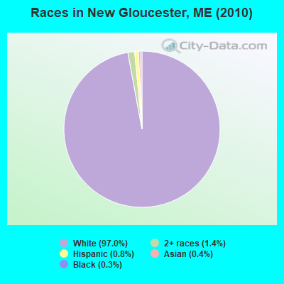
Races in New Gloucester detailed stats: ancestries, foreign born residents, place of birth
According to our research of Maine and other state lists, there were 9 registered sex offenders living in New Gloucester, Maine as of April 27, 2024.
The ratio of all residents to sex offenders in New Gloucester is 616 to 1.
The ratio of registered sex offenders to all residents in this city is near the state average.
 Recent articles from our blog. Our writers, many of them Ph.D. graduates or candidates, create easy-to-read articles on a wide variety of topics.


Latest news from New Gloucester, ME collected exclusively by city-data.com from local newspapers, TV, and radio stations
New Gloucester, ME City Guides:
Ancestries: English (27.0%), Irish (14.9%), French (11.5%), German (10.2%), United States (7.8%), Italian (6.9%).
Current Local Time: EST time zone
Incorporated on 03/08/1774
Elevation: 320 feet
Land area: 47.1 square miles.
Population density: 118 people per square mile (very low).
55 residents are foreign born
| This town: | 1.1% |
| Maine: | 2.9% |
| New Gloucester town: | 1.5% ($1,718) |
| Maine: | 1.5% ($1,417) |
Nearest city with pop. 50,000+: Portland, ME  (20.3 miles , pop. 64,249).
Nearest city with pop. 200,000+: Boston, MA (120.0 miles , pop. 589,141).
Nearest city with pop. 1,000,000+: Bronx, NY (282.2 miles , pop. 1,332,650).
Nearest cities:
), ), Latitude: 43.96 N, Longitude: 70.29 W
Area code: 207

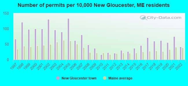
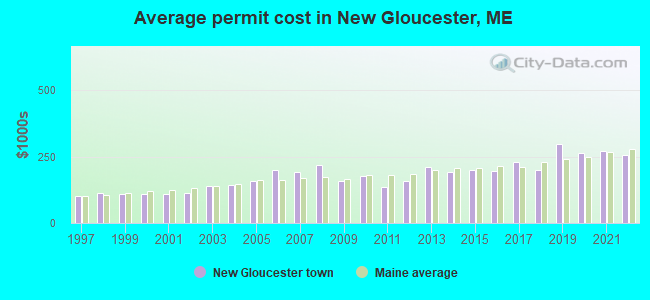
Single-family new house construction building permits:
- 2022: 20 buildings, average cost: $254,000
- 2021: 36 buildings, average cost: $270,200
- 2020: 27 buildings, average cost: $265,300
- 2019: 30 buildings, average cost: $296,400
- 2018: 29 buildings, average cost: $198,200
- 2017: 34 buildings, average cost: $230,300
- 2016: 22 buildings, average cost: $194,000
- 2015: 18 buildings, average cost: $200,000
- 2014: 13 buildings, average cost: $192,300
- 2013: 15 buildings, average cost: $212,000
- 2012: 10 buildings, average cost: $159,200
- 2011: 11 buildings, average cost: $135,900
- 2010: 8 buildings, average cost: $177,800
- 2009: 18 buildings, average cost: $156,500
- 2008: 23 buildings, average cost: $220,200
- 2007: 39 buildings, average cost: $193,100
- 2006: 30 buildings, average cost: $200,000
- 2005: 64 buildings, average cost: $157,900
- 2004: 43 buildings, average cost: $141,900
- 2003: 46 buildings, average cost: $138,000
- 2002: 63 buildings, average cost: $114,300
- 2001: 48 buildings, average cost: $109,600
- 2000: 48 buildings, average cost: $109,900
- 1999: 47 buildings, average cost: $108,700
- 1998: 58 buildings, average cost: $111,700
- 1997: 32 buildings, average cost: $100,500
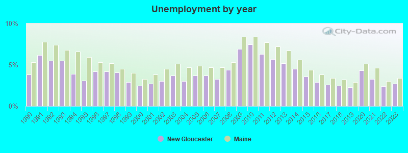
| Here: | 2.7% |
| Maine: | 3.4% |
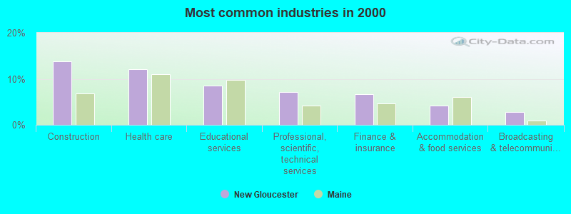
- Construction (13.8%)
- Health care (12.1%)
- Educational services (8.5%)
- Professional, scientific, technical services (7.2%)
- Finance & insurance (6.6%)
- Accommodation & food services (4.2%)
- Broadcasting & telecommunications (2.9%)
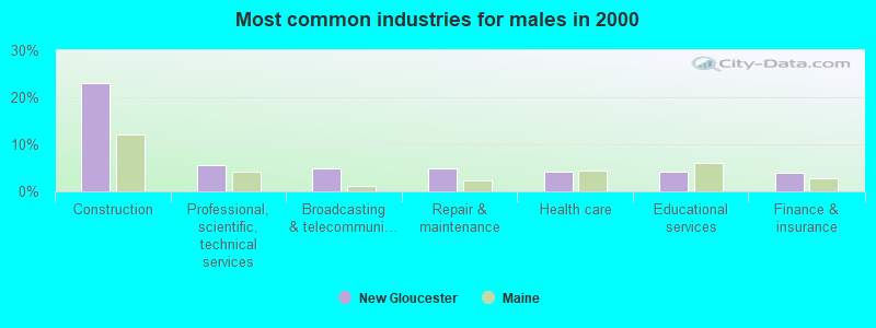
- Construction (23.1%)
- Professional, scientific, technical services (5.7%)
- Broadcasting & telecommunications (5.0%)
- Repair & maintenance (4.9%)
- Health care (4.3%)
- Educational services (4.1%)
- Finance & insurance (3.9%)
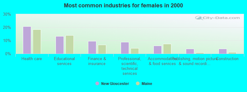
- Health care (20.6%)
- Educational services (13.2%)
- Finance & insurance (9.6%)
- Professional, scientific, technical services (8.8%)
- Accommodation & food services (6.2%)
- Publishing, motion picture & sound recording industries (3.7%)
- Construction (3.7%)
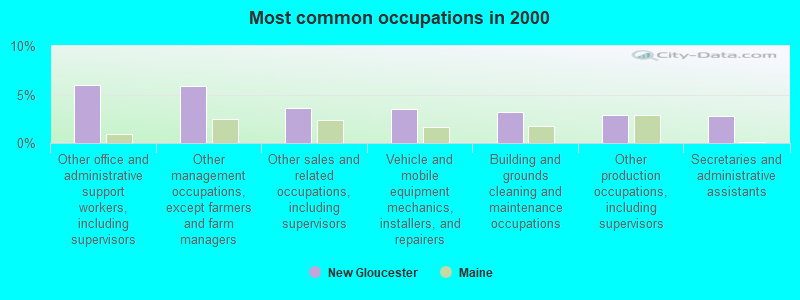
- Other office and administrative support workers, including supervisors (6.0%)
- Other management occupations, except farmers and farm managers (5.8%)
- Other sales and related occupations, including supervisors (3.6%)
- Vehicle and mobile equipment mechanics, installers, and repairers (3.5%)
- Building and grounds cleaning and maintenance occupations (3.2%)
- Other production occupations, including supervisors (2.9%)
- Secretaries and administrative assistants (2.7%)

- Vehicle and mobile equipment mechanics, installers, and repairers (6.7%)
- Construction traders workers except carpenters, electricians, painters, plumbers, and construction laborers (5.1%)
- Electrical equipment mechanics and other installation, maintenance, and repair workers, including supervisors (4.7%)
- Other management occupations, except farmers and farm managers (4.5%)
- Driver/sales workers and truck drivers (4.5%)
- Other production occupations, including supervisors (4.1%)
- Computer specialists (4.0%)
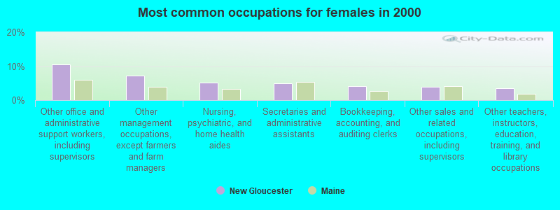
- Other office and administrative support workers, including supervisors (10.6%)
- Other management occupations, except farmers and farm managers (7.2%)
- Nursing, psychiatric, and home health aides (5.2%)
- Secretaries and administrative assistants (5.0%)
- Bookkeeping, accounting, and auditing clerks (4.1%)
- Other sales and related occupations, including supervisors (4.0%)
- Other teachers, instructors, education, training, and library occupations (3.6%)
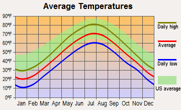
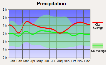
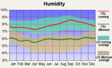
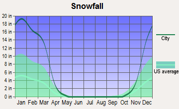
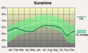
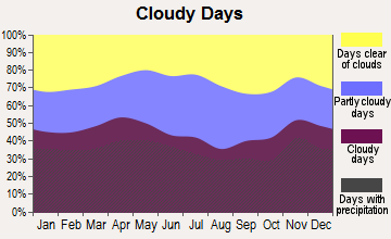
Average climate in New Gloucester, Maine
Based on data reported by over 4,000 weather stations

(lower is better)
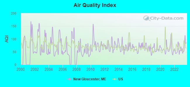
Air Quality Index (AQI) level in 2023 was 69.2. This is about average.
| City: | 69.2 |
| U.S.: | 72.6 |
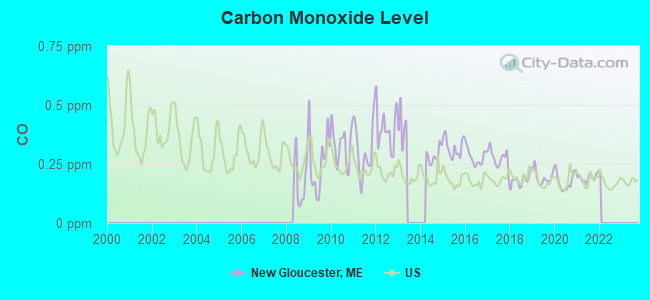
Carbon Monoxide (CO) [ppm] level in 2021 was 0.192. This is better than average. Closest monitor was 10.4 miles away from the city center.
| City: | 0.192 |
| U.S.: | 0.251 |
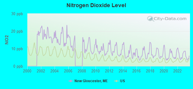
Nitrogen Dioxide (NO2) [ppb] level in 2023 was 5.47. This is about average. Closest monitor was 10.5 miles away from the city center.
| City: | 5.47 |
| U.S.: | 5.11 |
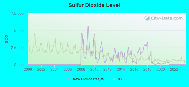
Sulfur Dioxide (SO2) [ppb] level in 2020 was 0.222. This is significantly better than average. Closest monitor was 6.7 miles away from the city center.
| City: | 0.222 |
| U.S.: | 1.515 |
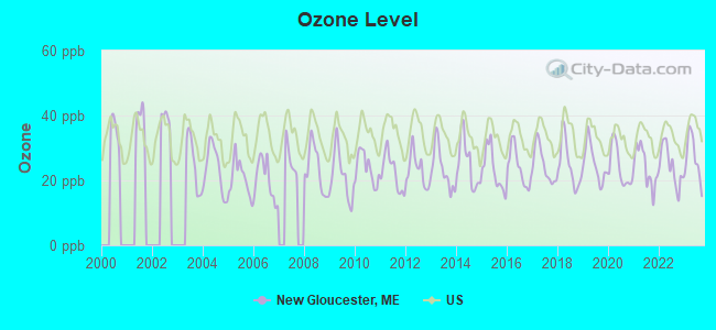
Ozone [ppb] level in 2023 was 26.9. This is better than average. Closest monitor was 4.7 miles away from the city center.
| City: | 26.9 |
| U.S.: | 33.3 |
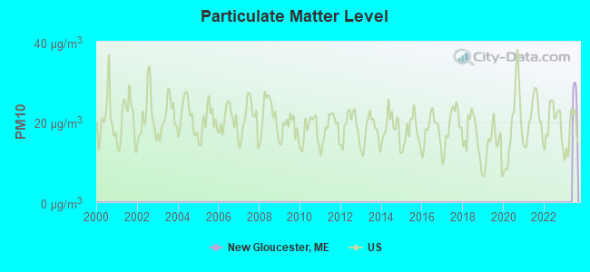
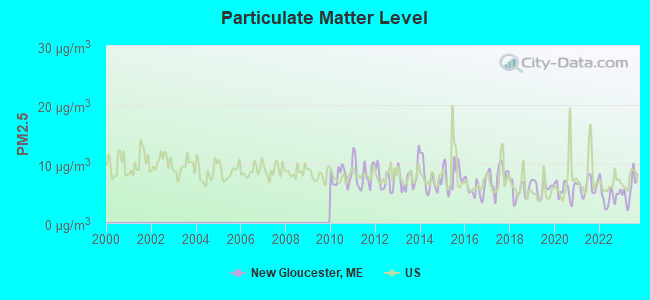
Particulate Matter (PM2.5) [µg/m3] level in 2023 was 5.84. This is better than average. Closest monitor was 10.0 miles away from the city center.
| City: | 5.84 |
| U.S.: | 8.11 |
Tornado activity:
New Gloucester-area historical tornado activity is above Maine state average. It is 80% smaller than the overall U.S. average.
On 7/8/1996, a category F2 (max. wind speeds 113-157 mph) tornado 23.0 miles away from the New Gloucester town center caused $10,000 in damages.
On 7/31/1971, a category F2 tornado 29.2 miles away from the town center caused between $50,000 and $500,000 in damages.
Earthquake activity:
New Gloucester-area historical earthquake activity is significantly above Maine state average. It is 75% smaller than the overall U.S. average.On 10/16/2012 at 23:12:25, a magnitude 4.7 (4.7 ML, Depth: 10.0 mi, Class: Light, Intensity: IV - V) earthquake occurred 30.7 miles away from New Gloucester center
On 4/20/2002 at 10:50:47, a magnitude 5.3 (5.3 ML, Depth: 3.0 mi, Class: Moderate, Intensity: VI - VII) earthquake occurred 172.9 miles away from the city center
On 4/20/2002 at 10:50:47, a magnitude 5.2 (5.2 MB, 4.2 MS, 5.2 MW, 5.0 MW) earthquake occurred 173.6 miles away from New Gloucester center
On 1/19/1982 at 00:14:42, a magnitude 4.7 (4.5 MB, 4.7 MD, 4.5 LG) earthquake occurred 72.5 miles away from the city center
On 10/7/1983 at 10:18:46, a magnitude 5.3 (5.1 MB, 5.3 LG, 5.1 ML) earthquake occurred 201.5 miles away from the city center
On 2/26/1999 at 03:38:43, a magnitude 3.8 (3.8 LG, Depth: 2.0 mi, Class: Light, Intensity: II - III) earthquake occurred 52.7 miles away from New Gloucester center
Magnitude types: regional Lg-wave magnitude (LG), body-wave magnitude (MB), duration magnitude (MD), local magnitude (ML), surface-wave magnitude (MS), moment magnitude (MW)
Natural disasters:
The number of natural disasters in Cumberland County (33) is a lot greater than the US average (15).Major Disasters (Presidential) Declared: 22
Emergencies Declared: 10
Causes of natural disasters: Floods: 19, Storms: 13, Snows: 7, Winter Storms: 6, Heavy Rains: 3, Hurricanes: 3, Winds: 3, Blizzard: 1, Ice Storm: 1, Mudslide: 1, Snowfall: 1, Snowstorm: 1, Tornado: 1, Other: 2 (Note: some incidents may be assigned to more than one category).
Hospitals and medical centers near New Gloucester:
- ANDROSCOGGIN KIDNEY CENTER (Dialysis Facility, about 9 miles away; AUBURN, ME)
- CLOVER HOME HEALTH, INC (Home Health Center, about 10 miles away; AUBURN, ME)
- CLOVER MANOR (Nursing Home, about 10 miles away; AUBURN, ME)
- BOLSTER HEIGHTS HEALTH CARE FACILITY (Nursing Home, about 10 miles away; AUBURN, ME)
- BEACON HOSPICE (Hospital, about 11 miles away; LEWISTON, ME)
- GOOD SHEPHERD HEALTH CARE - AUBURN (Nursing Home, about 11 miles away; AUBURN, ME)
- PROMENADE HEALTH CARE FACILITY (Nursing Home, about 11 miles away; AUBURN, ME)
Airports located in New Gloucester:
- Cliff Dow Airport (54ME) (Runways: 1)
Colleges/universities with over 2000 students nearest to New Gloucester:
- Saint Joseph's College of Maine (about 14 miles; Standish, ME; Full-time enrollment: 2,010)
- University of Southern Maine (about 21 miles; Portland, ME; FT enrollment: 6,647)
- Southern Maine Community College (about 22 miles; South Portland, ME; FT enrollment: 4,666)
- University of New England (about 35 miles; Biddeford, ME; FT enrollment: 4,539)
- University of Maine at Augusta (about 37 miles; Augusta, ME; FT enrollment: 3,204)
- University of Maine at Farmington (about 50 miles; Farmington, ME; FT enrollment: 2,036)
- University of New Hampshire-Main Campus (about 66 miles; Durham, NH; FT enrollment: 15,243)
Private high school in New Gloucester:
Public elementary/middle schools in New Gloucester:
- BURCHARD A DUNN SCHOOL (Students: 408, Location: 667 MORSE ROAD, Grades: PK-4)
- MEMORIAL SCHOOL (Location: 86 INTERVALE ROAD, Grades: KG-2)
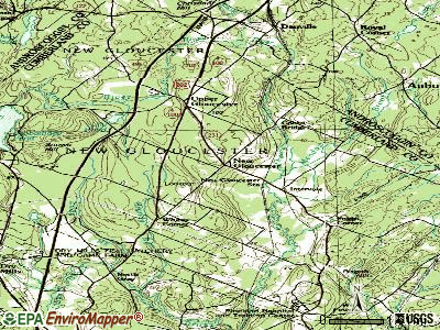
Points of interest:
Notable locations in New Gloucester: New Gloucester Station (A), Cobbs Bridge (B), New Gloucester Fish Hatchery (C), New Gloucester Fire Department Station 2 (D), New Gloucester Public Library (E), New Gloucester Volunteer Fire / Rescue Department (F). Display/hide their locations on the map
Churches in New Gloucester include: New Gloucester Bible Church (A), Universalist Meeting House (B). Display/hide their locations on the map
Cemeteries: Pineland Memorial Cemetery (1), Lower Corner Cemetery (2). Display/hide their locations on the map
Lakes, reservoirs, and swamps: Lily Pond (A), Sabbathday Pond (B), The Sinkhole (C), Royal River Reservoir (D), Brandy Bog (E). Display/hide their locations on the map
Streams, rivers, and creeks: Stevens Brook (A), Westcott Brook (B), Foster Brook (C), Meadow Brook (D), Mosquito Brook (E), Bear Brook (F). Display/hide their locations on the map
Park in New Gloucester: New Gloucester Historic District (1). Display/hide its location on the map
Tourist attraction: Shaker Society (Museums; 707 Shaker Road) (1). Display/hide its approximate location on the map
Drinking water stations with addresses in New Gloucester and their reported violations in the past:
PINELAND CENTER CAMPUS MSAD 15 (Population served: 1,230, Groundwater):Past monitoring violations:LUNN-HUNNEWELL & AUX AMVETS (Population served: 100, Groundwater):
- Monitoring and Reporting (DBP) - Between JAN-2008 and DEC-2010, Contaminant: Total Haloacetic Acids (HAA5). Follow-up actions: St Public Notif requested (DEC-08-2010), St Formal NOV issued (DEC-08-2010), St Public Notif received (DEC-30-2010), St Compliance achieved (JUN-20-2011)
- Monitoring and Reporting (DBP) - Between JAN-2008 and DEC-2010, Contaminant: TTHM. Follow-up actions: St Public Notif requested (DEC-08-2010), St Formal NOV issued (DEC-08-2010), St Public Notif received (DEC-30-2010), St Compliance achieved (JUN-20-2011)
- One routine major monitoring violation
Past monitoring violations:DUNNS CAMPS #2 (Population served: 76, Groundwater):
- 3 routine major monitoring violations
Past health violations:RISE & SHINE CHILD CARE CTR (Population served: 63, Groundwater):
- MCL, Monthly (TCR) - In JUN-2010, Contaminant: Coliform. Follow-up actions: St Public Notif received (JUN-19-2010), St Public Notif requested (JUL-06-2010), St Formal NOV issued (JUL-06-2010), St Compliance achieved (JUL-21-2010)
Past monitoring violations:KIDSQUARTERS CHILD CARE CENTER (Population served: 40, Groundwater):
- 4 routine major monitoring violations
- 54 regular monitoring violations
Past health violations:Past monitoring violations:
- MCL, Monthly (TCR) - In DEC-2013, Contaminant: Coliform. Follow-up actions: St Public Notif requested (JAN-07-2014), St Formal NOV issued (JAN-07-2014), St Compliance achieved (JAN-28-2014)
- 3 routine major monitoring violations
Drinking water stations with addresses in New Gloucester that have no violations reported:
- DUNNS CAMPS #1 (Population served: 25, Primary Water Source Type: Groundwater)
| This town: | 2.6 people |
| Maine: | 2.3 people |
| This town: | 73.3% |
| Whole state: | 62.9% |
| This town: | 10.0% |
| Whole state: | 9.4% |
Likely homosexual households (counted as self-reported same-sex unmarried-partner households)
- Lesbian couples: 0.7% of all households
- Gay men: 0.9% of all households
| This town: | 5.4% |
| Whole state: | 10.9% |
| This town: | 1.5% |
| Whole state: | 4.1% |
People in group quarters in New Gloucester in 2010:
- 14 people in group homes intended for adults
- 11 people in group homes for juveniles (non-correctional)
- 5 people in other noninstitutional facilities
People in group quarters in New Gloucester in 2000:
- 10 people in nursing homes
- 8 people in religious group quarters
- 5 people in homes for the mentally retarded
For population 15 years and over in New Gloucester:
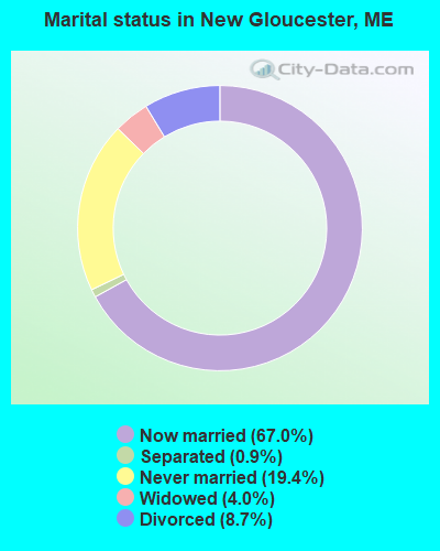
- Never married: 19.4%
- Now married: 67.0%
- Separated: 0.9%
- Widowed: 4.0%
- Divorced: 8.7%
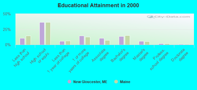
For population 25 years and over in New Gloucester:
- High school or higher: 89.5%
- Bachelor's degree or higher: 21.9%
- Graduate or professional degree: 8.4%
- Unemployed: 3.8%
- Mean travel time to work (commute): 25.5 minutes
| Here: | 10.4 |
| Maine average: | 11.2 |
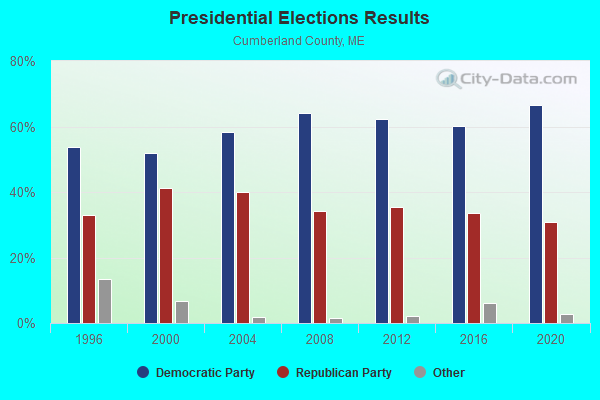
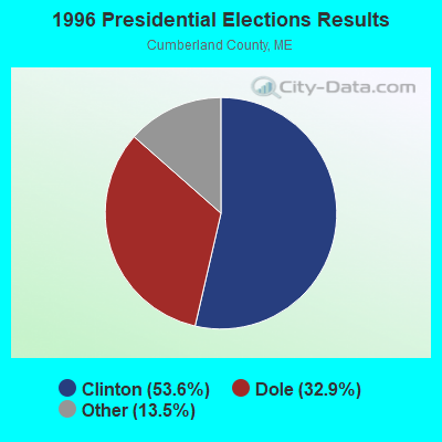
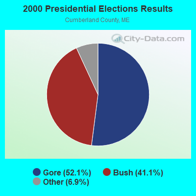


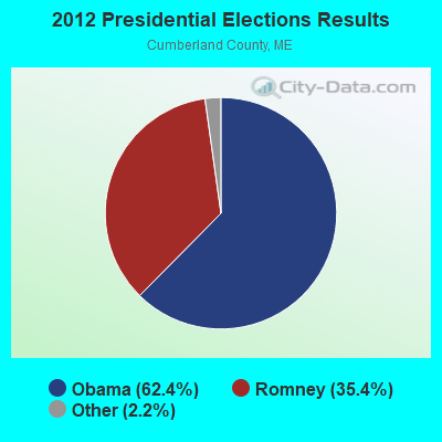


Graphs represent county-level data. Detailed 2008 Election Results
Political contributions by individuals in New Gloucester, ME
Religion statistics for New Gloucester, ME (based on Cumberland County data)
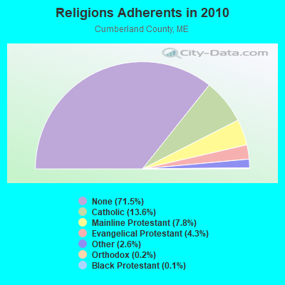
| Religion | Adherents | Congregations |
|---|---|---|
| Catholic | 38,243 | 19 |
| Mainline Protestant | 22,030 | 96 |
| Evangelical Protestant | 12,007 | 85 |
| Other | 7,187 | 44 |
| Orthodox | 500 | 1 |
| Black Protestant | 285 | 2 |
| None | 201,422 | - |
Food Environment Statistics:
| Cumberland County: | 2.62 / 10,000 pop. |
| State: | 2.80 / 10,000 pop. |
| Cumberland County: | 0.11 / 10,000 pop. |
| State: | 0.14 / 10,000 pop. |
| Cumberland County: | 2.44 / 10,000 pop. |
| State: | 2.20 / 10,000 pop. |
| Cumberland County: | 3.82 / 10,000 pop. |
| Maine: | 5.75 / 10,000 pop. |
| This county: | 12.01 / 10,000 pop. |
| Maine: | 11.02 / 10,000 pop. |
| This county: | 7.1% |
| State: | 8.2% |
| Cumberland County: | 19.5% |
| Maine: | 25.0% |
| Businesses in New Gloucester, ME | ||||
| Name | Count | Name | Count | |
|---|---|---|---|---|
| FedEx | 1 | UPS | 1 | |
| U-Haul | 1 | YMCA | 1 | |
Strongest AM radio stations in New Gloucester:
- WLAM (1470 AM; 5 kW; LEWISTON, ME; Owner: RADIO PARTNERS OF MAINE, L.P.)
- WGAN (560 AM; 5 kW; PORTLAND, ME; Owner: SAGA COMMUNICATIONS OF NEW ENGLAND, LLC)
- WMTW (870 AM; 10 kW; GORHAM, ME; Owner: RADIO PARTNERS OF MAINE, L.P.)
- WLOB (1310 AM; 5 kW; PORTLAND, ME; Owner: ATLANTIC COAST RADIO, LLC)
- WJAE (1440 AM; 5 kW; WESTBROOK, ME; Owner: ALTANTIC COAST RADIO, LLC)
- WZAN (970 AM; 5 kW; PORTLAND, ME; Owner: SAGA COMMUNICATIONS OF NEW ENGLAND, LLC)
- WTME (780 AM; 10 kW; RUMFORD, ME; Owner: MOUNTAIN VALLEY BROADCASTING, INC.)
- WCNM (1240 AM; 1 kW; LEWISTON, ME; Owner: CHRISTIAN FAMILY RADIO, INC.)
- WRKO (680 AM; 50 kW; BOSTON, MA; Owner: ENTERCOM BOSTON LICENSE, LLC)
- WJJB (900 AM; 1 kW; BRUNSWICK, ME; Owner: ATLANTIC COAST RADIO, LLC)
- WFAU (1280 AM; 5 kW; GARDINER, ME; Owner: CAPSTAR TX LIMITED PARTNERSHIP)
- WEEI (850 AM; 50 kW; BOSTON, MA; Owner: ENTERCOM BOSTON LICENSE, LLC)
- WBZ (1030 AM; 50 kW; BOSTON, MA; Owner: INFINITY BROADCASTING OPERATIONS, INC.)
Strongest FM radio stations in New Gloucester:
- WTHT (107.5 FM; LEWISTON, ME; Owner: RADIO PARTNERS OF MAINE, L.P.)
- WMEK-FM (99.9 FM; AUBURN, ME; Owner: RADIO PARTNERS OF MAINE, L.P.)
- WBLM (102.9 FM; PORTLAND, ME; Owner: CITADEL BROADCASTING COMPANY)
- WJBQ (97.9 FM; PORTLAND, ME; Owner: CITADEL BROADCASTING COMPANY)
- WMTW-FM (106.7 FM; NORTH WINDHAM, ME; Owner: RADIO PARTNERS OF MAINE, L.P.)
- WMEA (90.1 FM; PORTLAND, ME; Owner: MAINE PUBLIC BROADCASTING CORPORATION)
- WPOR (101.9 FM; PORTLAND, ME; Owner: SAGA COMMUNICATIONS OF NEW ENGLAND, LLC)
- WPKQ (103.7 FM; NORTH CONWAY, NH; Owner: CITADEL BROADCASTING COMPANY)
- WHOM (94.9 FM; MT. WASHINGTON, NH; Owner: CITADEL BROADCASTING COMPANY)
- WMSJ (89.3 FM; FREEPORT, ME; Owner: DOWNEAST CHRISTIAN COMMUNICATIONS)
- WJJB-FM (95.5 FM; TOPSHAM, ME; Owner: ATLANTIC COAST RADIO, LLC)
- WCLZ (98.9 FM; BRUNSWICK, ME; Owner: CITADEL BROADCASTING COMPANY)
- WCYI (93.9 FM; LEWISTON, ME; Owner: CITADEL BROADCASTING COMPANY)
- WSCY (106.9 FM; MOULTONBOROUGH, NH; Owner: NORTHEAST COMMUNICATIONS CORPORATION)
- WBCI (105.9 FM; BATH, ME; Owner: BLOUNT COMMUNICATIONS, INC.)
- WMGX (93.1 FM; PORTLAND, ME; Owner: SAGA COMMUNICATIONS OF NEW ENGLAND, LLC)
- WLOB-FM (96.3 FM; RUMFORD, ME; Owner: ATLANTIC COAST RADIO, LLC)
- WVFM (105.7 FM; CAMPTON, NH; Owner: DEVON BROADCASTING COMPANY, INC.)
- WTBM (100.7 FM; MEXICO, ME; Owner: MOUNTAIN VALLEY BROADCASTING, INC.)
- WYNZ (100.9 FM; WESTBROOK, ME; Owner: SAGA COMMUNICATIONS OF NEW ENGLAND, LLC)
TV broadcast stations around New Gloucester:
- WGME-TV (Channel 13; PORTLAND, ME; Owner: WGME LICENSEE, LLC)
- WPXT (Channel 51; PORTLAND, ME; Owner: HMW, INC.)
- WPME (Channel 35; LEWISTON, ME; Owner: KB PRIME MEDIA LLC)
- W32CA (Channel 32; PORTLAND, ME; Owner: NATIONAL MINORITY T.V., INC.)
- WMTW-TV (Channel 8; POLAND SPRING, ME; Owner: WMTW BROADCAST GROUP, LLC)
- WCSH (Channel 6; PORTLAND, ME; Owner: PACIFIC AND SOUTHERN COMPANY, INC.)
- WPFO (Channel 23; WATERVILLE, ME; Owner: CMCG PORTLAND LICENSE LLC)
- WCBB (Channel 10; AUGUSTA, ME; Owner: MAINE PUBLIC BROADCASTING CORP.)
- WMEA-TV (Channel 26; BIDDEFORD, ME; Owner: MAINE PUBLIC BROADCASTING CORP.)
- W58CM (Channel 58; BANGOR, ME; Owner: MS COMMUNICATIONS, LLC)
- W57AP (Channel 57; FALMOUTH, ME; Owner: SHERWOOD H. CRAIG)
- WLLB-LP (Channel 15; PORTLAND, ME; Owner: CARTER BROADCASTING CORPORATION)
- National Bridge Inventory (NBI) Statistics
- 9Number of bridges
- 98ft / 30.3mTotal length
- 44,396Total average daily traffic
- 2,216Total average daily truck traffic
- 62,850Total future (year 2036) average daily traffic
FCC Registered Cell Phone Towers:
1 (See the full list of FCC Registered Cell Phone Towers in New Gloucester)FCC Registered Antenna Towers:
40 (See the full list of FCC Registered Antenna Towers)FCC Registered Commercial Land Mobile Towers:
1- Gloucester Hill Road (Lat: 43.952028 Lon: -70.295611), Structure height: 153 m, Call Sign: KPK286,
Assigned Frequencies: 450.980 MHz, Grant Date: 09/21/1990, Expiration Date: 04/01/2030, Registrant: Fletcher, Heald & Hildreth, P.L.C., 1300 N. 17th St., 11th Floor, Arlington, VA 20009-3801, Phone: (703) 812-0404, Fax: (703) 812-0486, Email:
FCC Registered Broadcast Land Mobile Towers:
6- Fire Station Upper Gloucester (Lat: 43.991472 Lon: -70.299222), Call Sign: KCG567,
Assigned Frequencies: 154.265 MHz, 154.310 MHz, Grant Date: 05/08/2013, Expiration Date: 04/27/2023, Cancellation Date: 07/15/2023, Registrant: Radio Communications Management, 158 Rand Rd, Portland, ME 04105, Phone: (207) 797-7503, Email:
- 385 Intervale Road Rte 231 (Lat: 44.964444 Lon: -70.281944), Type: Pipe, Structure height: 19.2 m, Overall height: 22.3 m, Call Sign: WNAJ918,
Assigned Frequencies: 154.265 MHz, 154.310 MHz, Grant Date: 11/05/2004, Expiration Date: 12/13/2014, Cancellation Date: 10/20/2010, Registrant: Androscoggin County Of, Eoc 2 College Street, Lewiston, ME 04240-7101, Phone: (207) 784-0147, Fax: (207) 784-0149, Email:
- 385 Intervale Road Rte 231 (Lat: 44.964444 Lon: -70.281944), Type: Pipe, Structure height: 19.2 m, Overall height: 22.3 m, Call Sign: KNIQ339,
Assigned Frequencies: 154.115 MHz, Grant Date: 11/05/2004, Expiration Date: 06/01/2014, Cancellation Date: 10/20/2010, Registrant: Androscoggin County Of, Eoc 2 College Street, Lewiston, ME 04240-7101, Phone: (207) 784-0147, Fax: (207) 784-0149, Email:
- Gloucester Hill Rd 300 Ft Ne Bennet Rd (Lat: 43.949528 Lon: -70.293389), Call Sign: KQZ954,
Assigned Frequencies: 155.430 MHz, Grant Date: 12/24/2014, Expiration Date: 02/06/2025, Registrant: New Gloucester Fire Dept., 385 Intervale Road, New Gloucester, ME 04260, Phone: (207) 926-4142, Fax: (207) 926-4136, Email:
- NEW GLOUC PUMP STA., Bald Hill Road (Lat: 43.994944 Lon: -70.304861), Type: Pole, Structure height: 13 m, Overall height: 15 m, Call Sign: WQPG705,
Assigned Frequencies: 173.203 MHz, Grant Date: 02/16/2022, Expiration Date: 05/14/2032, Certifier: John B Storer, Registrant: Auburn Water & Sewerage Districts, 268 Court Street, Auburn, ME 04212-0414, Phone: (207) 784-6469, Fax: (207) 784-6460, Email:
- NEW GLOUCESTER, Gloucester Hill Rd (Lat: 43.950278 Lon: -70.295444), Type: Ltower, Structure height: 60.9 m, Call Sign: WSAK677,
Assigned Frequencies: 151.107 MHz, 155.625 MHz, 154.875 MHz, Grant Date: 01/24/2024, Expiration Date: 01/24/2034, Certifier: Melinda Dyer, Registrant: Radio Communications Management, 158 Rand Rd, Portland, ME 04103, Phone: (207) 797-7503, Email:
FCC Registered Microwave Towers:
11 (See the full list of FCC Registered Microwave Towers in this town)FCC Registered Amateur Radio Licenses:
40 (See the full list of FCC Registered Amateur Radio Licenses in New Gloucester)FAA Registered Aircraft:
7- Aircraft: CESSNA 172M (Category: Land, Seats: 4, Weight: Up to 12,499 Pounds, Speed: 108 mph), Engine: LYCOMING 0-320 SERIES (180 HP) (4 Cycle)
N-Number: 20215, N20215, N-20215, Serial Number: 17261101, Year manufactured: 1972, Airworthiness Date: 10/31/1972, Certificate Issue Date: 03/01/2019
Registrant (LLC): Northeastern Financial LLC, 60 Pineland Dr Ste 312, New Gloucester, ME 04260 - Aircraft: AERONCA 65-CA (Category: Land, Seats: 2, Weight: Up to 12,499 Pounds, Speed: 75 mph), Engine: CONT MOTOR A&C65 SERIES (65 HP) (Reciprocating)
N-Number: 31992, N31992, N-31992, Serial Number: C-12701, Airworthiness Date: 02/17/1956, Certificate Issue Date: 08/16/2017
Registrant (Individual): Rp Field Rider, 80 Gloucester Hill Rd, New Gloucester, ME 04260
Deregistered: Cancel Date: 09/29/2014 - Aircraft: CESSNA 180 (Category: Land, Seats: 4, Weight: Up to 12,499 Pounds, Speed: 121 mph), Engine: CONT MOTOR O-470 SERIES (230 HP) (Reciprocating)
N-Number: 4796B, N4796B, N-4796B, Serial Number: 31694, Year manufactured: 1955, Airworthiness Date: 06/16/1956, Certificate Issue Date: 11/27/2018
Registrant (Individual): Kenneth R Hough, 51 Meadow Ln, New Gloucester, ME 04260 - Aircraft: PIPER PA-22-108 (Category: Land, Seats: 2, Weight: Up to 12,499 Pounds, Speed: 94 mph), Engine: LYCOMING 0-235 SERIES (115 HP) (Reciprocating)
N-Number: 5354Z, N5354Z, N-5354Z, Serial Number: 22-9077, Year manufactured: 1961, Airworthiness Date: 09/27/1961, Certificate Issue Date: 10/24/2020
Registrant (Individual): Timothy C Manson, 116a Cobble Hill Rd, New Gloucester, ME 04260 - Aircraft: BELLANCA 7GCBC (Category: Land, Seats: 2, Weight: Up to 12,499 Pounds, Speed: 90 mph), Engine: LYCOMING 0-320 SERIES (180 HP) (Reciprocating)
N-Number: 53912, N53912, N-53912, Serial Number: 904-76, Year manufactured: 1976, Airworthiness Date: 02/24/1976, Certificate Issue Date: 01/24/1998
Registrant (Individual): R.P. Field Rider, 80 Gloucester Hill Rd, New Gloucester, ME 04260 - Aircraft: BEECH V35B (Category: Land, Seats: 6, Weight: Up to 12,499 Pounds, Speed: 150 mph), Engine: CONT MOTOR IO 520 SERIES (285 HP) (Reciprocating)
N-Number: 853, N853, N-853, Serial Number: D-9888, Airworthiness Date: 05/10/1976, Certificate Issue Date: 04/16/2019
Registrant (Corporation): Cameo Marketing Inc, 60 Pineland Dr Ste 306, New Gloucester, ME 04260 - Aircraft: CESSNA 172 (Category: Land, Seats: 4, Weight: Up to 12,499 Pounds, Speed: 105 mph), Engine: Reciprocating
N-Number: 107LA, N107LA, N-107LA, Serial Number: 28122, Certificate Issue Date: 04/04/2017
Registrant (Individual): Charles L Tripp, 75 Mcintire Rd, New Gloucester, ME 04260
2003 - 2018 National Fire Incident Reporting System (NFIRS) incidents
- Fire incident types reported to NFIRS in New Gloucester, ME
- 12546.6%Structure Fires
- 9836.6%Outside Fires
- 3914.6%Mobile Property/Vehicle Fires
- 62.2%Other
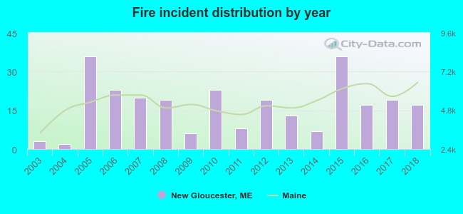 Based on the data from the years 2003 - 2018 the average number of fire incidents per year is 17. The highest number of reported fire incidents - 36 took place in 2005, and the least - 2 in 2004. The data has a growing trend.
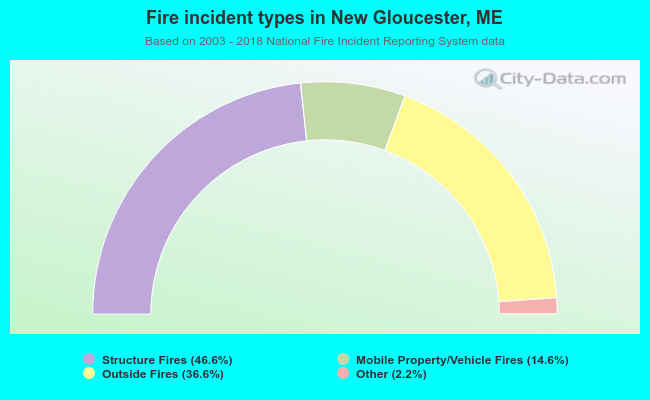 When looking into fire subcategories, the most reports belonged to: Structure Fires (46.6%), and Outside Fires (36.6%).
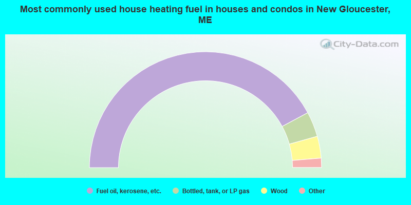
- 84.3%Fuel oil, kerosene, etc.
- 7.0%Bottled, tank, or LP gas
- 6.1%Wood
- 1.2%Electricity
- 0.7%Other fuel
- 0.7%Utility gas
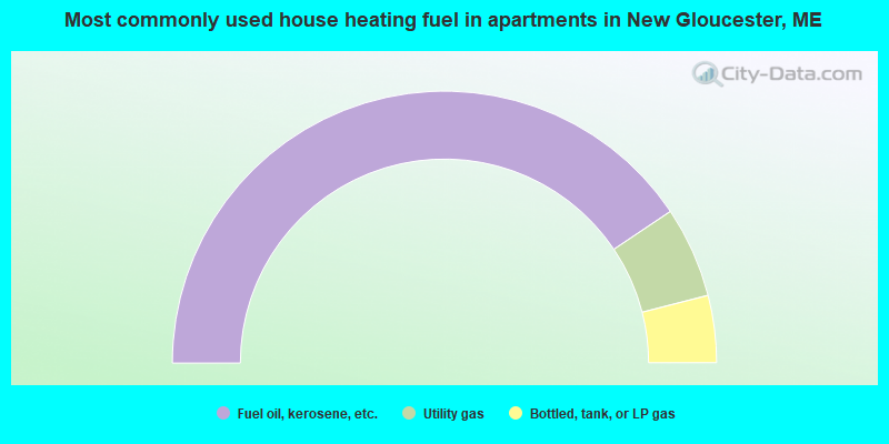
- 81.2%Fuel oil, kerosene, etc.
- 10.8%Utility gas
- 8.0%Bottled, tank, or LP gas
New Gloucester compared to Maine state average:
- Unemployed percentage significantly below state average.
- Black race population percentage significantly below state average.
- Hispanic race population percentage below state average.
- Foreign-born population percentage significantly below state average.
- Renting percentage below state average.
- Length of stay since moving in significantly above state average.
- Number of rooms per house significantly below state average.
- House age significantly below state average.
New Gloucester on our top lists:
- #7 on the list of "Top 101 cities with largest percentage of females in occupations: legal support workers (population 5,000+)"
- #13 on the list of "Top 101 cities with largest percentage of males in occupations: woodworkers (population 5,000+)"
- #15 on the list of "Top 101 cities with largest percentage of males in industries: broadcasting and telecommunications (population 5,000+)"
- #16 on the list of "Top 101 cities with largest percentage of males in occupations: child care workers (population 5,000+)"
- #16 on the list of "Top 101 cities with largest percentage of males in occupations: financial clerks except bookkeeping, accounting, and auditing clerks (population 5,000+)"
- #16 on the list of "Top 101 cities with largest percentage of females in industries: leather and allied products (population 5,000+)"
- #18 on the list of "Top 101 cities with largest percentage of females in industries: publishing, and motion picture and sound recording industries (population 5,000+)"
- #20 on the list of "Top 101 cities with largest percentage of males in industries: beverage and tobacco products (population 5,000+)"
- #20 on the list of "Top 101 cities with largest percentage of females in industries: building material and garden equipment and supplies dealers (population 5,000+)"
- #20 on the list of "Top 101 cities with largest percentage of males in industries: social assistance (population 5,000+)"
- #21 on the list of "Top 101 cities with largest percentage of males in industries: used merchandise, gift, novelty, and souvenir, and other miscellaneous stores (population 5,000+)"
- #25 on the list of "Top 101 cities with largest percentage of males in industries: gasoline stations (population 5,000+)"
- #26 on the list of "Top 101 cities with largest percentage of females in occupations: other management occupations except farmers and farm managers (population 5,000+)"
- #28 on the list of "Top 101 cities with largest percentage of females in occupations: other office and administrative support workers including supervisors (population 5,000+)"
- #38 on the list of "Top 101 cities with largest percentage of females in industries: electronic shopping and mail-order houses (population 5,000+)"
- #51 on the list of "Top 101 cities with largest percentage of females in industries: miscellaneous durable goods merchant wholesalers (population 5,000+)"
- #52 on the list of "Top 101 cities with largest percentage of males in industries: office supplies and stationery stores (population 5,000+)"
- #76 on the list of "Top 101 cities with largest percentage of males in industries: leather and allied products (population 5,000+)"
- #92 on the list of "Top 101 cities with largest percentage of males in industries: u. s. postal service (population 5,000+)"
- #93 on the list of "Top 101 cities with the largest percentage of likely gay men couples (counted as self-reported male-male unmarried-partner households) (population 5,000+)"
- #28 on the list of "Top 101 counties with the highest percentage of residents that exercised in the past month"
- #30 on the list of "Top 101 counties with the best general health status score of residents (1-5), 3 years of data"
- #40 on the list of "Top 101 counties with the highest percentage of residents that visited a dentist within the past year"
- #43 on the list of "Top 101 counties with the highest Nitrogen Dioxide air pollution readings in 2012 (ppm)"
- #49 on the list of "Top 101 counties with the lowest number of births per 1000 residents 2007-2013"

|
|
Total of 14 patent applications in 2008-2024.