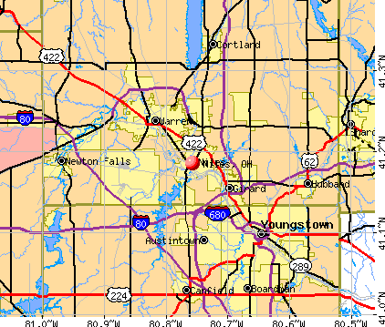
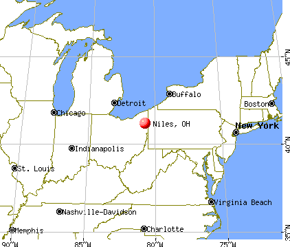
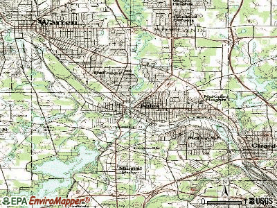
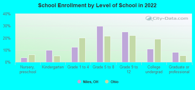
Niles, Ohio
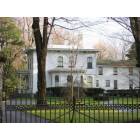
Niles: Ward-Thomas House on city's South Side
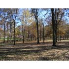
Niles: Waddel Park

Niles: new high being built
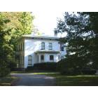
Niles: Ward-Thomas House
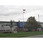
Niles: Niles McKinley High School
- add
your
Submit your own pictures of this city and show them to the world
- OSM Map
- General Map
- Google Map
- MSN Map
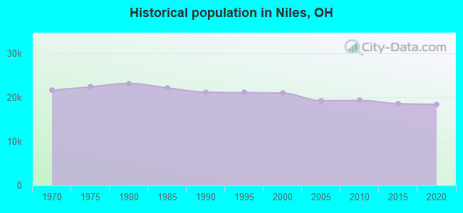
Population change since 2000: -12.6%
 |
| Males: 8,993 | |
| Females: 9,293 |
| Median resident age: | 44.4 years |
| Ohio median age: | 39.9 years |
Zip codes: 44446.
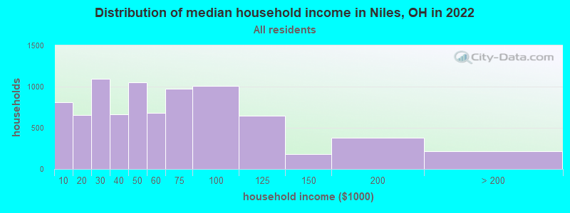
| Niles: | $48,571 |
| OH: | $65,720 |
Estimated per capita income in 2022: $30,610 (it was $19,441 in 2000)
Niles city income, earnings, and wages data
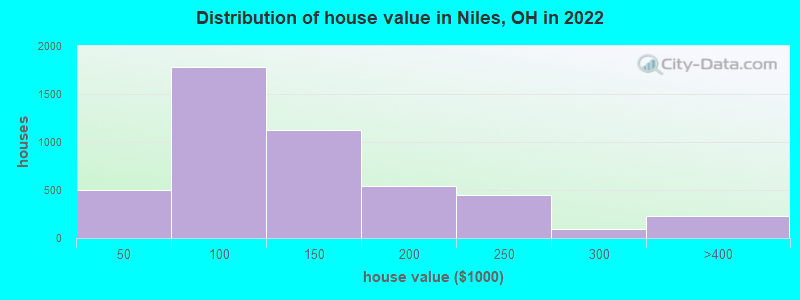
Estimated median house or condo value in 2022: $104,423 (it was $79,200 in 2000)
| Niles: | $104,423 |
| OH: | $204,100 |
Mean prices in 2022: all housing units: $130,533; detached houses: $131,973; townhouses or other attached units: $161,642; in 2-unit structures: $105,009; in 3-to-4-unit structures: $134,521; in 5-or-more-unit structures: $183,837; mobile homes: $5,975
Median gross rent in 2022: $720.
(12.1% for White Non-Hispanic residents, 30.3% for Black residents, 9.2% for Hispanic or Latino residents, 100.0% for Native Hawaiian and other Pacific Islander residents, 23.9% for two or more races residents)
Detailed information about poverty and poor residents in Niles, OH


Compare current foreclosures in Niles, OH:
| Photo | Address | Area | Beds / Baths | Price | Details |
|---|---|---|---|---|---|

|
#1
Robbins Ave
Niles, OH 44446
|
2,679 sq. feet
|
3 baths 4 beds |
show details | |

|
#2
Cardigan St
Niles, OH 44446
|
720 sq. feet
|
1 baths 2 beds |
show details | |

|
#3
Sayers Ave
Niles, OH 44446
|
1,785 sq. feet
|
2 baths 5 beds |
show details | |

|
#4
And One Half Mason Street
Niles, OH 44446
|
1,664 sq. feet
|
2 baths 4 beds |
show details | |

|
#5
& 308 1/2 Grant Street
Niles, OH 44446
|
- sq. feet
|
- baths - beds |
$19,900
|
show details |

|
#6
Scott Ave
Niles, OH 44446
|
1,300 sq. feet
|
2 baths 2 beds |
show details | |

|
#7
Belmont Ave
Niles, OH 44446
|
1,575 sq. feet
|
2 baths 3 beds |
show details | |

|
#8
Woodglen Ave
Niles, OH 44446
|
888 sq. feet
|
2 baths 2 beds |
show details | |

|
#9
N Rhodes Ave
Niles, OH 44446
|
1,746 sq. feet
|
1 baths 3 beds |
show details | |

|
#10
Warren Ave
Niles, OH 44446
|
674 sq. feet
|
1 baths 2 beds |
show details |
| Photo | Address | Area | Beds / Baths | Price | Details |
|---|---|---|---|---|---|

|
#11
Trumbull Dr
Niles, OH 44446
|
1,757 sq. feet
|
1 baths 3 beds |
show details | |

|
#12
Lincoln Ave
Niles, OH 44446
|
966 sq. feet
|
1 baths 3 beds |
show details | |

|
#13
Oak Forest Dr
Niles, OH 44446
|
3,100 sq. feet
|
2 baths 3 beds |
show details | |

|
#14
Williams St
Niles, OH 44446
|
918 sq. feet
|
1 baths 3 beds |
show details | |

|
#15
Oak Knoll St
Niles, OH 44446
|
816 sq. feet
|
1 baths 3 beds |
show details | |

|
#16
Peffer Ave
Niles, OH 44446
|
1,346 sq. feet
|
1 baths 3 beds |
show details | |

|
#17
Holford Ave
Niles, OH 44446
|
1,680 sq. feet
|
1 baths 3 beds |
show details | |

|
#18
S Cleveland Ave
Niles, OH 44446
|
1,032 sq. feet
|
1 baths 4 beds |
show details | |

|
#19
Holtz St
Niles, OH 44446
|
1,368 sq. feet
|
1 baths 5 beds |
show details | |

|
#20
Washington Ave
Niles, OH 44446
|
1,200 sq. feet
|
1 baths 2 beds |
show details |
| Photo | Address | Area | Beds / Baths | Price | Details |
|---|---|---|---|---|---|

|
#21
Vienna Ave
Niles, OH 44446
|
1,716 sq. feet
|
2 baths 3 beds |
show details | |

|
#22
Bowman St
Niles, OH 44446
|
1,576 sq. feet
|
1 baths 3 beds |
show details | |

|
#23
Mistletoe Rd
Niles, OH 44446
|
988 sq. feet
|
2 baths 3 beds |
show details | |

|
#24
Lakeview Rd
Niles, OH 44446
|
1,388 sq. feet
|
2 baths 3 beds |
show details | |

|
#25
Garland Dr
Niles, OH 44446
|
1,040 sq. feet
|
1 baths 3 beds |
show details | |

|
#26
Hartzell Ave
Niles, OH 44446
|
936 sq. feet
|
2 baths 4 beds |
show details | |

|
#27
Lincoln Ave
Niles, OH 44446
|
1,289 sq. feet
|
2 baths 4 beds |
show details | |

|
#28
Lafayette Ave
Niles, OH 44446
|
825 sq. feet
|
1 baths 3 beds |
show details | |

|
#29
Pepperwood Dr
Niles, OH 44446
|
1,708 sq. feet
|
1 baths 3 beds |
show details | |

|
#30
Vienna Ave
Niles, OH 44446
|
1,512 sq. feet
|
2 baths 3 beds |
show details |
| Photo | Address | Area | Beds / Baths | Price | Details |
|---|---|---|---|---|---|

|
#31
Robbins Ave
Niles, OH 44446
|
1,844 sq. feet
|
2 baths 3 beds |
show details | |

|
#32
Prospect St
Niles, OH 44446
|
1,140 sq. feet
|
- baths 3 beds |
show details | |

|
#33
Salt Springs Rd
Niles, OH 44446
|
- sq. feet
|
- baths - beds |
show details | |

|
#34
Hillcrest Ave # 8
Niles, OH 44446
|
- sq. feet
|
- baths - beds |
show details | |

|
#35
Niles Cortland Rd
Niles, OH 44446
|
- sq. feet
|
- baths - beds |
show details | |

|
#36
Kearney St
Niles, OH 44446
|
- sq. feet
|
- baths - beds |
show details | |

|
#37
North Rd Apt 169
Niles, OH 44446
|
- sq. feet
|
- baths - beds |
show details | |

|
#38
Scott Ave
Niles, OH 44446
|
- sq. feet
|
- baths - beds |
show details | |

|
#39
13th St
Niles, OH 44446
|
- sq. feet
|
- baths - beds |
show details | |

|
#40
Robbins Ave Apt 30
Niles, OH 44446
|
- sq. feet
|
- baths - beds |
show details |
| Photo | Address | Area | Beds / Baths | Price | Details |
|---|---|---|---|---|---|

|
#41
Youngstown Warren Rd Apt 103
Niles, OH 44446
|
- sq. feet
|
- baths - beds |
show details | |

|
#42
Arms Blvd Apt 3
Niles, OH 44446
|
- sq. feet
|
- baths - beds |
show details | |

|
#43
Youngstown Warren Rd Apt 44
Niles, OH 44446
|
- sq. feet
|
- baths - beds |
show details | |

|
#44
S Cedar Ave
Niles, OH 44446
|
- sq. feet
|
- baths - beds |
show details | |

|
#45
Lafayette Ave # 4
Niles, OH 44446
|
- sq. feet
|
- baths - beds |
show details | |

|
#46
Robbins Ave
Niles, OH 44446
|
- sq. feet
|
- baths - beds |
show details | |

|
Check over 1 million property listings on Foreclosure.com!
|
browse all offers | |||


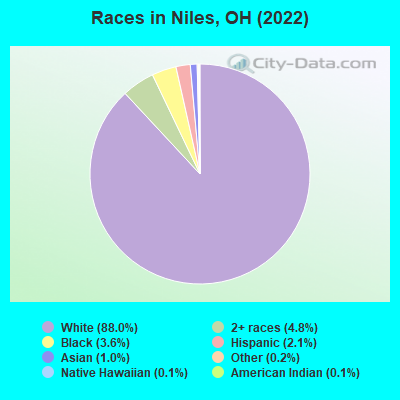
- 15,84988.0%White alone
- 8644.8%Two or more races
- 6443.6%Black alone
- 3762.1%Hispanic
- 1891.0%Asian alone
- 320.2%Other race alone
- 190.1%American Indian alone
- 200.1%Native Hawaiian and Other
Pacific Islander alone
Races in Niles detailed stats: ancestries, foreign born residents, place of birth
According to our research of Ohio and other state lists, there were 28 registered sex offenders living in Niles, Ohio as of April 27, 2024.
The ratio of all residents to sex offenders in Niles is 664 to 1.
The ratio of registered sex offenders to all residents in this city is near the state average.
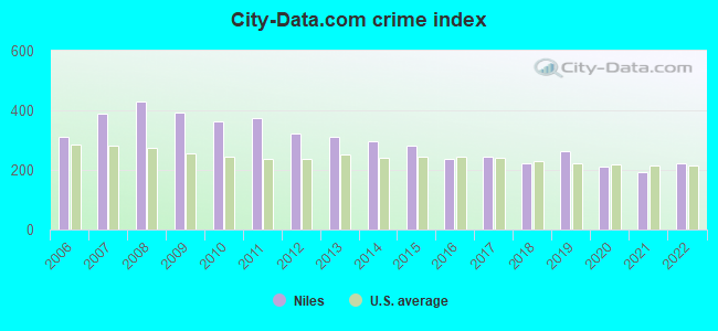
Type |
2009 |
2010 |
2011 |
2012 |
2013 |
2014 |
2015 |
2016 |
2017 |
2018 |
2019 |
2020 |
2021 |
2022 |
|---|---|---|---|---|---|---|---|---|---|---|---|---|---|---|
| Murders (per 100,000) | 0 (0.0) | 0 (0.0) | 0 (0.0) | 0 (0.0) | 0 (0.0) | 0 (0.0) | 1 (5.4) | 1 (5.4) | 0 (0.0) | 1 (5.4) | 2 (11.0) | 0 (0.0) | 0 (0.0) | 0 (0.0) |
| Rapes (per 100,000) | 7 (36.7) | 8 (41.5) | 4 (20.7) | 4 (20.9) | 2 (10.6) | 4 (21.2) | 3 (16.1) | 9 (48.5) | 8 (43.6) | 9 (49.0) | 11 (60.4) | 9 (49.8) | 9 (50.2) | 9 (49.1) |
| Robberies (per 100,000) | 23 (120.5) | 22 (114.2) | 33 (171.2) | 25 (130.4) | 30 (158.3) | 36 (191.0) | 32 (171.4) | 21 (113.3) | 11 (60.0) | 12 (65.3) | 17 (93.3) | 9 (49.8) | 6 (33.4) | 16 (87.2) |
| Assaults (per 100,000) | 23 (120.5) | 15 (77.9) | 23 (119.3) | 17 (88.7) | 19 (100.3) | 24 (127.3) | 23 (123.2) | 23 (124.1) | 37 (201.8) | 21 (114.3) | 44 (241.5) | 22 (121.7) | 20 (111.5) | 27 (147.2) |
| Burglaries (per 100,000) | 261 (1,367) | 196 (1,017) | 264 (1,369) | 217 (1,132) | 196 (1,034) | 130 (689.7) | 122 (653.6) | 79 (426.2) | 110 (600.0) | 81 (440.9) | 47 (257.9) | 80 (442.7) | 60 (334.4) | 69 (376.1) |
| Thefts (per 100,000) | 873 (4,572) | 845 (4,386) | 846 (4,388) | 739 (3,856) | 712 (3,757) | 648 (3,438) | 588 (3,150) | 433 (2,336) | 471 (2,569) | 418 (2,275) | 414 (2,272) | 413 (2,286) | 385 (2,146) | 401 (2,186) |
| Auto thefts (per 100,000) | 59 (309.0) | 81 (420.4) | 26 (134.9) | 36 (187.8) | 28 (147.8) | 23 (122.0) | 24 (128.6) | 14 (75.5) | 19 (103.6) | 16 (87.1) | 20 (109.8) | 18 (99.6) | 25 (139.3) | 29 (158.1) |
| Arson (per 100,000) | 3 (15.7) | 1 (5.2) | 1 (5.2) | 1 (5.2) | 2 (10.6) | 1 (5.3) | 0 (0.0) | 1 (5.4) | 0 (0.0) | 0 (0.0) | 0 (0.0) | 1 (5.5) | 1 (5.6) | 3 (16.4) |
| City-Data.com crime index | 392.8 | 363.3 | 374.0 | 322.1 | 310.5 | 295.3 | 281.7 | 237.7 | 246.3 | 221.4 | 264.2 | 209.5 | 192.8 | 221.3 |
The City-Data.com crime index weighs serious crimes and violent crimes more heavily. Higher means more crime, U.S. average is 246.1. It adjusts for the number of visitors and daily workers commuting into cities.
Crime rate in Niles detailed stats: murders, rapes, robberies, assaults, burglaries, thefts, arson
Full-time law enforcement employees in 2021, including police officers: 42 (36 officers - 35 male; 1 female).
| Officers per 1,000 residents here: | 2.01 |
| Ohio average: | 2.31 |
 Recent articles from our blog. Our writers, many of them Ph.D. graduates or candidates, create easy-to-read articles on a wide variety of topics.

 | Leaving Niles (6 replies) |
| From Canton to Niles (4 replies) |
| Oberlin Question (12 replies) |
| Decline of Macy's, Kroger's (239 replies) |
| Likely moving to the Youngstown-Warren metropolitan area... (30 replies) |
| Canfield, Ohio... I'm confused! (11 replies) |
Latest news from Niles, OH collected exclusively by city-data.com from local newspapers, TV, and radio stations
Ancestries: American (38.9%), Italian (16.4%), Irish (8.3%), German (5.4%), English (4.1%), Scottish (1.8%).
Current Local Time: EST time zone
Elevation: 890 feet
Land area: 8.55 square miles.
Population density: 2,138 people per square mile (low).
374 residents are foreign born (1.3% Asia, 0.4% Europe, 0.3% Latin America).
| This city: | 2.1% |
| Ohio: | 4.9% |
Median real estate property taxes paid for housing units with mortgages in 2022: $1,294 (1.3%)
Median real estate property taxes paid for housing units with no mortgage in 2022: $1,310 (1.2%)
Nearest city with pop. 50,000+: Youngstown, OH  (8.3 miles , pop. 82,026).
Nearest city with pop. 200,000+: Akron, OH (40.4 miles , pop. 217,074).
Nearest city with pop. 1,000,000+: Philadelphia, PA (305.9 miles , pop. 1,517,550).
Nearest cities:
), ), ), ), ), )Latitude: 41.19 N, Longitude: 80.76 W
Daytime population change due to commuting: +580 (+3.2%)
Workers who live and work in this city: 1,687 (20.2%)
Area code: 330

Niles, Ohio accommodation & food services, waste management - Economy and Business Data
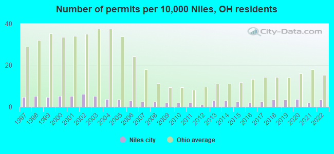
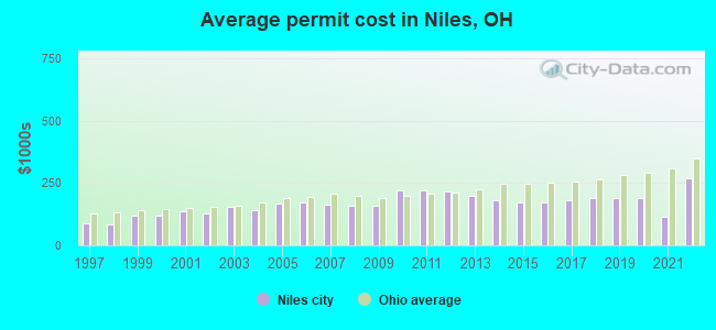
Single-family new house construction building permits:
- 2022: 7 buildings, average cost: $271,400
- 2021: 4 buildings, average cost: $112,500
- 2020: 8 buildings, average cost: $190,600
- 2019: 7 buildings, average cost: $190,600
- 2018: 7 buildings, average cost: $190,600
- 2017: 5 buildings, average cost: $183,400
- 2016: 4 buildings, average cost: $171,800
- 2015: 5 buildings, average cost: $171,400
- 2014: 6 buildings, average cost: $181,800
- 2013: 6 buildings, average cost: $197,000
- 2012: 2 buildings, average cost: $215,700
- 2011: 4 buildings, average cost: $221,200
- 2010: 4 buildings, average cost: $221,200
- 2009: 4 buildings, average cost: $158,800
- 2008: 5 buildings, average cost: $158,800
- 2007: 5 buildings, average cost: $161,600
- 2006: 6 buildings, average cost: $174,100
- 2005: 7 buildings, average cost: $168,100
- 2004: 8 buildings, average cost: $138,700
- 2003: 11 buildings, average cost: $152,800
- 2002: 13 buildings, average cost: $127,800
- 2001: 11 buildings, average cost: $135,800
- 2000: 11 buildings, average cost: $119,000
- 1999: 10 buildings, average cost: $119,300
- 1998: 11 buildings, average cost: $84,500
- 1997: 10 buildings, average cost: $90,000
| Here: | 4.0% |
| Ohio: | 3.1% |
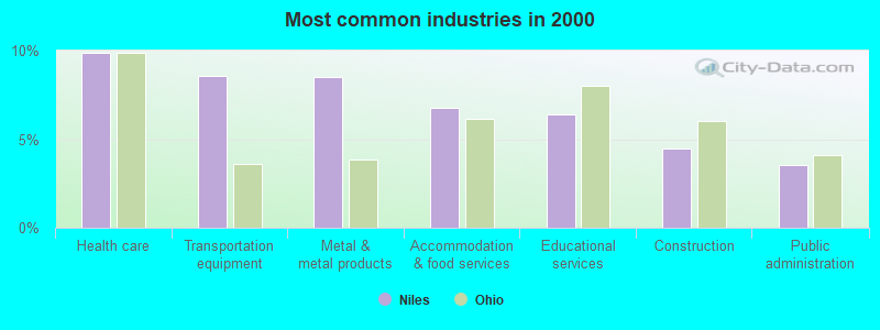
- Health care (9.9%)
- Transportation equipment (8.6%)
- Metal & metal products (8.5%)
- Accommodation & food services (6.8%)
- Educational services (6.4%)
- Construction (4.5%)
- Public administration (3.6%)
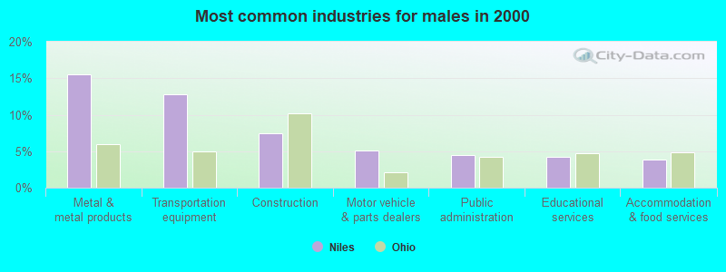
- Metal & metal products (15.5%)
- Transportation equipment (12.8%)
- Construction (7.5%)
- Motor vehicle & parts dealers (5.1%)
- Public administration (4.5%)
- Educational services (4.2%)
- Accommodation & food services (3.9%)
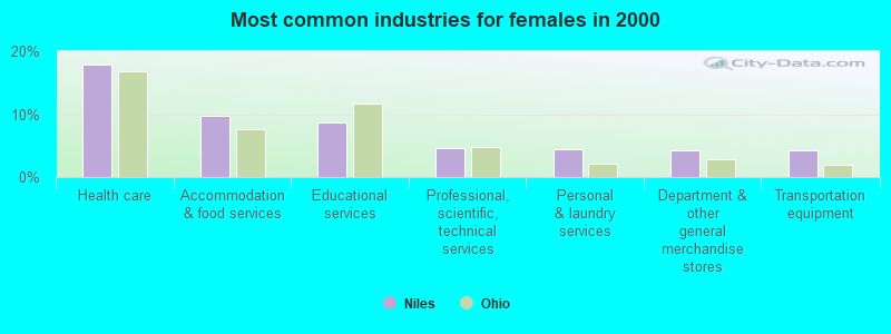
- Health care (17.8%)
- Accommodation & food services (9.8%)
- Educational services (8.7%)
- Professional, scientific, technical services (4.6%)
- Personal & laundry services (4.5%)
- Department & other general merchandise stores (4.3%)
- Transportation equipment (4.2%)
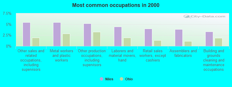
- Other sales and related occupations, including supervisors (5.4%)
- Metal workers and plastic workers (5.4%)
- Other production occupations, including supervisors (5.2%)
- Laborers and material movers, hand (4.5%)
- Retail sales workers, except cashiers (4.0%)
- Assemblers and fabricators (3.8%)
- Building and grounds cleaning and maintenance occupations (3.3%)
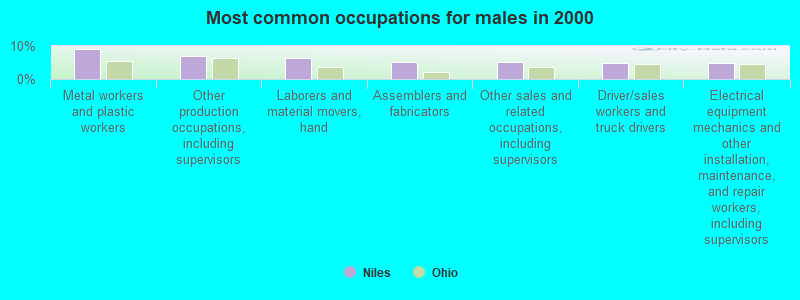
- Metal workers and plastic workers (9.1%)
- Other production occupations, including supervisors (6.9%)
- Laborers and material movers, hand (6.3%)
- Assemblers and fabricators (5.2%)
- Other sales and related occupations, including supervisors (5.1%)
- Driver/sales workers and truck drivers (4.9%)
- Electrical equipment mechanics and other installation, maintenance, and repair workers, including supervisors (4.8%)

- Other sales and related occupations, including supervisors (5.8%)
- Secretaries and administrative assistants (5.5%)
- Other office and administrative support workers, including supervisors (4.5%)
- Cashiers (4.1%)
- Retail sales workers, except cashiers (4.1%)
- Health technologists and technicians (3.7%)
- Nursing, psychiatric, and home health aides (3.5%)
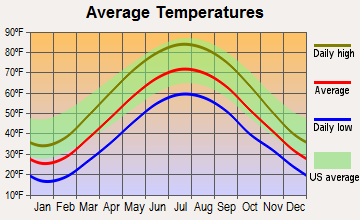
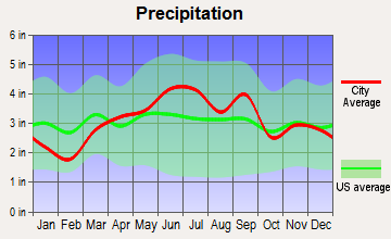
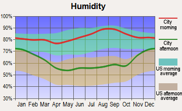
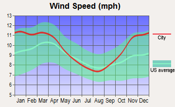
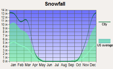
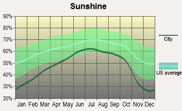
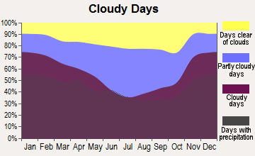
Average climate in Niles, Ohio
Based on data reported by over 4,000 weather stations
|
|

(lower is better)
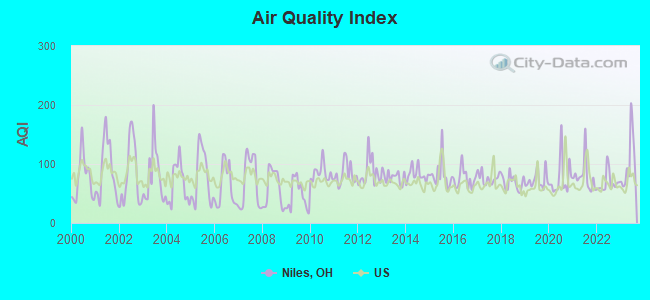
Air Quality Index (AQI) level in 2023 was 103. This is significantly worse than average.
| City: | 103 |
| U.S.: | 73 |
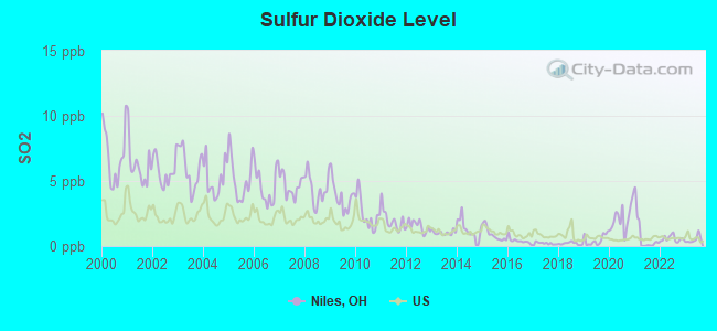
Sulfur Dioxide (SO2) [ppb] level in 2023 was 0.501. This is significantly better than average. Closest monitor was 4.6 miles away from the city center.
| City: | 0.501 |
| U.S.: | 1.515 |
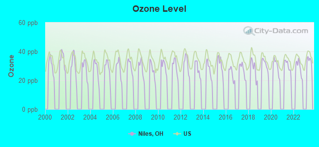
Ozone [ppb] level in 2022 was 28.7. This is about average. Closest monitor was 7.0 miles away from the city center.
| City: | 28.7 |
| U.S.: | 33.3 |
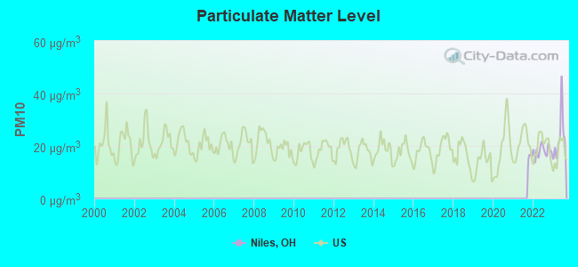
Particulate Matter (PM10) [µg/m3] level in 2023 was 23.3. This is worse than average. Closest monitor was 2.6 miles away from the city center.
| City: | 23.3 |
| U.S.: | 19.2 |
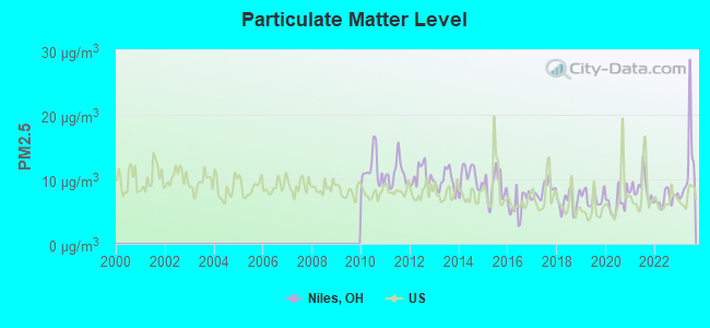
Particulate Matter (PM2.5) [µg/m3] level in 2023 was 12.0. This is significantly worse than average. Closest monitor was 2.6 miles away from the city center.
| City: | 12.0 |
| U.S.: | 8.1 |
Tornado activity:
Niles-area historical tornado activity is slightly below Ohio state average. It is 4% greater than the overall U.S. average.
On 5/31/1985, a category F5 (max. wind speeds 261-318 mph) tornado 20.5 miles away from the Niles city center killed 18 people and injured 310 people and caused between $50,000,000 and $500,000,000 in damages.
On 5/31/1985, a category F4 (max. wind speeds 207-260 mph) tornado 23.8 miles away from the city center killed 16 people and injured 125 people and caused between $5,000,000 and $50,000,000 in damages.
Earthquake activity:
Niles-area historical earthquake activity is significantly above Ohio state average. It is 54% smaller than the overall U.S. average.On 9/25/1998 at 19:52:52, a magnitude 5.2 (4.8 MB, 4.3 MS, 5.2 LG, 4.5 MW, Depth: 3.1 mi, Class: Moderate, Intensity: VI - VII) earthquake occurred 28.3 miles away from Niles center
On 1/31/1986 at 16:46:43, a magnitude 5.0 (5.0 MB) earthquake occurred 35.6 miles away from Niles center
On 8/23/2011 at 17:51:04, a magnitude 5.8 (5.8 MW, Depth: 3.7 mi) earthquake occurred 271.9 miles away from the city center
On 12/31/2011 at 20:05:01, a magnitude 4.0 (4.0 ML, Depth: 3.1 mi, Class: Light, Intensity: IV - V) earthquake occurred 5.8 miles away from the city center
On 7/27/1980 at 18:52:21, a magnitude 5.2 (5.1 MB, 4.7 MS, 5.0 UK, 5.2 UK) earthquake occurred 266.9 miles away from the city center
On 6/10/2019 at 14:50:45, a magnitude 4.0 (4.0 MB, Depth: 1.2 mi) earthquake occurred 49.8 miles away from the city center
Magnitude types: regional Lg-wave magnitude (LG), body-wave magnitude (MB), local magnitude (ML), surface-wave magnitude (MS), moment magnitude (MW)
Natural disasters:
The number of natural disasters in Trumbull County (10) is smaller than the US average (15).Major Disasters (Presidential) Declared: 6
Emergencies Declared: 3
Causes of natural disasters: Storms: 6, Floods: 5, Tornadoes: 5, Blizzard: 1, Hurricane: 1, Power Outage: 1, Snowstorm: 1, Wind: 1, Other: 1 (Note: some incidents may be assigned to more than one category).
Main business address for: RTI INTERNATIONAL METALS INC (ROLLING DRAWING & EXTRUDING OF NONFERROUS METALS).
Hospitals and medical centers in Niles:
- AUTUMN HILLS CARE CENTER (2565 NILES VIENNA RD)
- SHEPHERD OF THE VALLEY - NILES (1500 MCKINLEY AVENUE)
Other hospitals and medical centers near Niles:
- ARM/CDC, LTD. (Dialysis Facility, about 3 miles away; WARREN, OH)
- BRIARFIELD AT THE RIDGE (Nursing Home, about 3 miles away; MINERAL RIDGE, OH)
- GLENN VIEW MANOR (Nursing Home, about 3 miles away; MINERAL RIDGE, OH)
- RIDGE CREST CARE CENTER (Nursing Home, about 3 miles away; WARREN, OH)
- WHITE OAK MANOR (Nursing Home, about 3 miles away; WARREN, OH)
- PRIMARY NURSING CARE (Home Health Center, about 3 miles away; WARREN, OH)
- ENRICHMENT CENTER INC (Hospital, about 3 miles away; WARREN, OH)
Colleges/Universities in Niles:
- Ross Medical Education Center-Niles (Full-time enrollment: 338; Location: 5555 Youngstown-Warren Rd, Unit 909; Private, for-profit; Website: www.rosseducation.edu)
- ETI Technical College (Full-time enrollment: 278; Location: 2076 Youngstown Warren Rd; Private, for-profit; Website: eticollege.edu)
- Raphael's School of Beauty Culture Inc-Niles (Full-time enrollment: 195; Location: 1324 Youngstown Warren Rd; Private, for-profit; Website: www.raphaelsbeautyschool.com)
Colleges/universities with over 2000 students nearest to Niles:
- Youngstown State University (about 8 miles; Youngstown, OH; Full-time enrollment: 11,575)
- University of Mount Union (about 27 miles; Alliance, OH; FT enrollment: 2,302)
- Kent State University at Kent (about 31 miles; Kent, OH; FT enrollment: 25,431)
- Grove City College (about 36 miles; Grove City, PA; FT enrollment: 2,560)
- Slippery Rock University of Pennsylvania (about 38 miles; Slippery Rock, PA; FT enrollment: 8,424)
- Walsh University (about 39 miles; North Canton, OH; FT enrollment: 2,553)
- University of Akron Main Campus (about 40 miles; Akron, OH; FT enrollment: 22,216)
Private high school in Niles:
Public elementary/middle schools in Niles:
- NILES MIDDLE SCHOOL (Students: 601, Location: 411 BROWN ST, Grades: 6-8)
- NILES PRIMARY SCHOOL (Location: 960 FREDERICK ST, Grades: KG-2)
- NILES INTERMEDIATE SCHOOL (Location: 120 E MARGARET AVE, Grades: 3-5)
Private elementary/middle school in Niles:
Points of interest:
Notable locations in Niles: Lane Life Corporation Station 4 (A), Niles Fire Department Station 7 (B), McKinley Birthplace Memorial (C). Display/hide their locations on the map
Shopping Centers: Great East Plaza Shopping Center (1), Romar Plaza Shopping Center (2), The Village Center Shopping Center (3), Jamesplace Plaza Shopping Center (4), Niles Plaza Shopping Center (5), Eastwood Mall Shopping Center (6). Display/hide their locations on the map
Main business address in Niles: RTI INTERNATIONAL METALS INC (A). Display/hide its location on the map
Churches in Niles include: Niles Christian Assembly Church (A), Trinity Lutheran Church (B), First Christian Church (C), First Baptist Church (D), Our Lady of Mount Carmel Catholic Church (E), Mount Sinai Church of God in Christ (F), Fairview United Methodist Church (G), Niles Wesleyan Methodist Church (H), First Presbyterian Church of Niles (I). Display/hide their locations on the map
Cemetery: Niles Union Cemetery (1). Display/hide its location on the map
Creek: Meander Creek (A). Display/hide its location on the map
Parks in Niles include: Circle Park (1), Stevens Park (2). Display/hide their locations on the map
Tourist attraction: Garden State Carousels LLC (Amusement & Theme Parks; 5555 Youngstown Warren Road).
Hotels: Days Inn (1300 Youngstown Warren Road), Forest City Motor Inn (1300 Youngstown Warren Road), Country Inn & Suites by Carlson-Youngstown West (5570 Interstate Boulevard), Four-Twenty-Two Motel (5318 Youngstown Warren Road), Equity Corporation Housing (18 Arms Boulevard).
Birthplace of: William McKinley - (died 1901), Tim Ryan, Bo Rein - Football player and coach, George Burns (first baseman) - Baseball player, John Ghindia - Football player, Keith W. Piper - Football player and coach, Tim Ryan (politician) - Ohio politician, Billy Lyell - Boxer, Dan Jones - College basketball player (Youngstown State Penguins), Dominic Sena - Film director.
| This city: | 2.2 people |
| Ohio: | 2.4 people |
| This city: | 58.5% |
| Whole state: | 65.0% |
| This city: | 8.2% |
| Whole state: | 6.8% |
Likely homosexual households (counted as self-reported same-sex unmarried-partner households)
- Lesbian couples: 0.3% of all households
- Gay men: 0.3% of all households
People in group quarters in Niles in 2010:
- 222 people in nursing facilities/skilled-nursing facilities
- 18 people in residential treatment centers for juveniles (non-correctional)
- 14 people in group homes intended for adults
- 8 people in residential treatment centers for adults
People in group quarters in Niles in 2000:
- 398 people in nursing homes
- 13 people in other group homes
- 7 people in other noninstitutional group quarters
- 6 people in local jails and other confinement facilities (including police lockups)
Banks with most branches in Niles (2011 data):
- The Farmers National Bank of Canfield: Niles Drive-In Branch, Downtown Niles Office, 422 Branch. Info updated 2006/11/03: Bank assets: $1,055.8 mil, Deposits: $846.0 mil, headquarters in Canfield, OH, positive income, 17 total offices, Holding Company: Farmers National Banc Corp.
- PNC Bank, National Association: Niles Branch, Mckinley Plaza Branch, Niles Drive-Up Branch. Info updated 2012/03/20: Bank assets: $263,309.6 mil, Deposits: $197,343.0 mil, headquarters in Wilmington, DE, positive income, Commercial Lending Specialization, 3085 total offices, Holding Company: Pnc Financial Services Group, Inc., The
- First Place Bank: Niles Branch at 6002 Warren-Youngstown Road, branch established on 2006/07/25. Info updated 2011/07/21: Bank assets: $2,754.5 mil, Deposits: $2,219.6 mil, headquarters in Warren, OH, negative income in the last year, Commercial Lending Specialization, 43 total offices
- Home Federal Savings and Loan Association of Niles: Home Federal Savings And Loan Associ at 55 North Main Street, branch established on 1897/01/01. Info updated 2011/07/21: Bank assets: $103.5 mil, Deposits: $60.0 mil, local headquarters, positive income, Mortgage Lending Specialization, 1 total offices
- The Home Savings and Loan Company: Eastwood Branch at 980 Great East Plaza, branch established on 1889/01/01. Info updated 2009/06/25: Bank assets: $2,035.1 mil, Deposits: $1,617.8 mil, headquarters in Youngstown, OH, positive income, Commercial Lending Specialization, 35 total offices
- The Cortland Savings and Banking Company: Niles Park Plaza at 815 Youngstown Warren Road, branch established on 1999/05/17. Info updated 2006/11/03: Bank assets: $516.5 mil, Deposits: $423.2 mil, headquarters in Cortland, OH, positive income, Commercial Lending Specialization, 14 total offices, Holding Company: Cortland Bancorp
- The Huntington National Bank: Eastwood Branch at 5555 Youngstown Warren Road, branch established on 1969/07/10. Info updated 2012/04/02: Bank assets: $54,183.4 mil, Deposits: $44,300.3 mil, headquarters in Columbus, OH, positive income, Commercial Lending Specialization, 878 total offices, Holding Company: Huntington Bancshares Incorporated
- U.S. Bank National Association: Niles Giant Eagle at 48 Vienna Ave, branch established on 1998/07/12. Info updated 2012/01/30: Bank assets: $330,470.8 mil, Deposits: $236,091.5 mil, headquarters in Cincinnati, OH, positive income, 3121 total offices, Holding Company: U.S. Bancorp
- JPMorgan Chase Bank, National Association: Eastwood Mall Branch at 5555 Youngstown Warren Road, branch established on 1970/04/13. Info updated 2011/11/10: Bank assets: $1,811,678.0 mil, Deposits: $1,190,738.0 mil, headquarters in Columbus, OH, positive income, International Specialization, 5577 total offices, Holding Company: Jpmorgan Chase & Co.
For population 15 years and over in Niles:
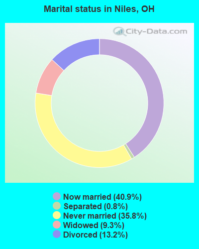
- Never married: 35.8%
- Now married: 40.9%
- Separated: 0.8%
- Widowed: 9.3%
- Divorced: 13.2%
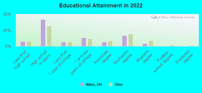
For population 25 years and over in Niles:
- High school or higher: 90.1%
- Bachelor's degree or higher: 21.4%
- Graduate or professional degree: 6.2%
- Unemployed: 7.9%
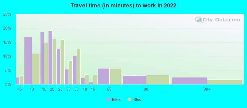
- Mean travel time to work (commute): 21.9 minutes
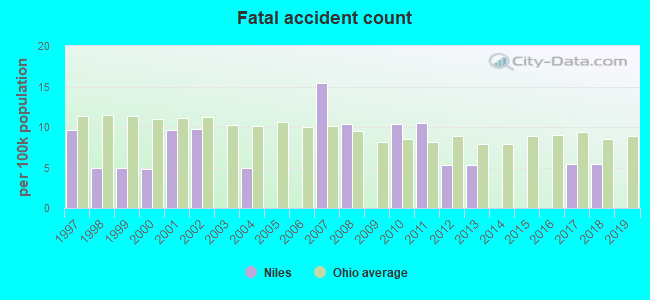
| Here: | 9.6 |
| Ohio average: | 11.0 |
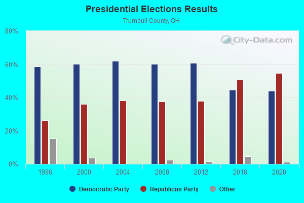
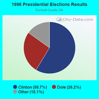
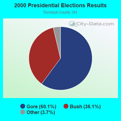
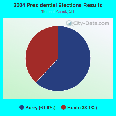
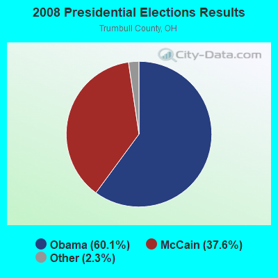
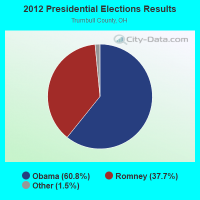
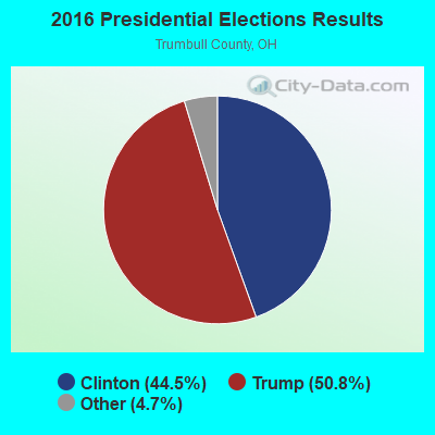
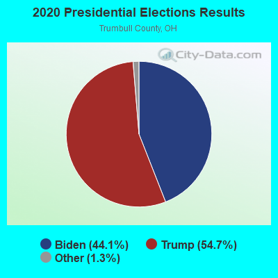
Graphs represent county-level data. Detailed 2008 Election Results
Religion statistics for Niles, OH (based on Trumbull County data)
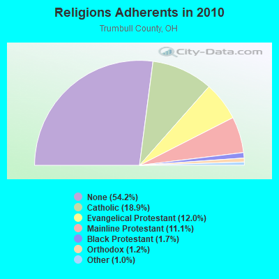
| Religion | Adherents | Congregations |
|---|---|---|
| Catholic | 39,749 | 23 |
| Evangelical Protestant | 25,155 | 141 |
| Mainline Protestant | 23,326 | 87 |
| Black Protestant | 3,479 | 14 |
| Orthodox | 2,493 | 5 |
| Other | 2,198 | 16 |
| None | 113,912 | - |
Food Environment Statistics:
| This county: | 2.30 / 10,000 pop. |
| State: | 1.89 / 10,000 pop. |
| Here: | 0.09 / 10,000 pop. |
| Ohio: | 0.13 / 10,000 pop. |
| This county: | 1.59 / 10,000 pop. |
| Ohio: | 1.25 / 10,000 pop. |
| This county: | 3.14 / 10,000 pop. |
| State: | 2.93 / 10,000 pop. |
| This county: | 6.00 / 10,000 pop. |
| Ohio: | 6.25 / 10,000 pop. |
| Trumbull County: | 10.8% |
| Ohio: | 10.3% |
| Here: | 27.9% |
| State: | 29.1% |
| Trumbull County: | 12.6% |
| State: | 11.9% |
Health and Nutrition:
| This city: | 55.0% |
| State: | 50.4% |
| This city: | 54.6% |
| Ohio: | 47.8% |
| Here: | 28.2 |
| Ohio: | 28.7 |
| This city: | 19.1% |
| Ohio: | 20.6% |
| Niles: | 8.4% |
| Ohio: | 10.4% |
| Niles: | 7.0 |
| State: | 6.8 |
| Here: | 34.2% |
| State: | 34.3% |
| Niles: | 61.6% |
| State: | 57.0% |
| Here: | 79.8% |
| Ohio: | 79.1% |
More about Health and Nutrition of Niles, OH Residents
| Local government employment and payroll (March 2022) | |||||
| Function | Full-time employees | Monthly full-time payroll | Average yearly full-time wage | Part-time employees | Monthly part-time payroll |
|---|---|---|---|---|---|
| Firefighters | 33 | $212,135 | $77,140 | 0 | $0 |
| Police Protection - Officers | 33 | $203,678 | $74,065 | 0 | $0 |
| Electric Power | 32 | $155,685 | $58,382 | 1 | $1,223 |
| Judicial and Legal | 11 | $31,318 | $34,165 | 1 | $1,919 |
| Water Supply | 10 | $38,251 | $45,901 | 0 | $0 |
| Solid Waste Management | 9 | $41,357 | $55,143 | 0 | $0 |
| Financial Administration | 8 | $31,920 | $47,880 | 2 | $1,562 |
| Streets and Highways | 8 | $37,389 | $56,084 | 0 | $0 |
| Sewerage | 7 | $26,488 | $45,408 | 0 | $0 |
| Police - Other | 6 | $26,058 | $52,116 | 3 | $3,107 |
| Other Government Administration | 6 | $24,381 | $48,762 | 14 | $7,382 |
| Parks and Recreation | 4 | $16,885 | $50,655 | 2 | $1,907 |
| Correction | 2 | $5,166 | $30,996 | 0 | $0 |
| Other and Unallocable | 2 | $5,794 | $34,764 | 0 | $0 |
| Totals for Government | 171 | $856,504 | $60,106 | 23 | $17,100 |
Niles government finances - Expenditure in 2021 (per resident):
- Construction - Sewerage: $1,765,000 ($96.52)
- Current Operations - Electric Utilities: $26,965,000 ($1474.63)
Water Utilities: $7,643,000 ($417.97)
General - Other: $5,857,000 ($320.30)
Sewerage: $4,701,000 ($257.08)
Local Fire Protection: $3,645,000 ($199.33)
Police Protection: $3,598,000 ($196.76)
Housing and Community Development: $918,000 ($50.20)
Parks and Recreation: $860,000 ($47.03)
Judicial and Legal Services: $788,000 ($43.09)
Central Staff Services: $505,000 ($27.62)
Financial Administration: $362,000 ($19.80)
Transit Utilities: $10,000 ($0.55)
- General - Interest on Debt: $176,000 ($9.62)
Niles government finances - Revenue in 2021 (per resident):
- Charges - Sewerage: $3,946,000 ($215.79)
Parks and Recreation: $291,000 ($15.91)
- Federal Intergovernmental - Other: $1,999,000 ($109.32)
- Miscellaneous - General Revenue - Other: $7,360,000 ($402.49)
Fines and Forfeits: $955,000 ($52.23)
Interest Earnings: $524,000 ($28.66)
- Revenue - Electric Utilities: $27,456,000 ($1501.48)
Water Utilities: $8,627,000 ($471.78)
Transit Utilities: $10,000 ($0.55)
- State Intergovernmental - Other: $549,000 ($30.02)
Water Utilities: $232,000 ($12.69)
Highways: $200,000 ($10.94)
- Tax - Individual Income: $9,639,000 ($527.12)
Property: $821,000 ($44.90)
Public Utilities Sales: $790,000 ($43.20)
Other Selective Sales: $761,000 ($41.62)
Motor Vehicle License: $364,000 ($19.91)
Amusements License: $10,000 ($0.55)
Alcoholic Beverage License: $1,000 ($0.05)
Niles government finances - Debt in 2021 (per resident):
- Long Term Debt - Outstanding Unspecified Public Purpose: $4,500,000 ($246.09)
Beginning Outstanding - Unspecified Public Purpose: $4,500,000 ($246.09)
| Businesses in Niles, OH | ||||
| Name | Count | Name | Count | |
|---|---|---|---|---|
| AT&T | 2 | New York & Co | 1 | |
| Advance Auto Parts | 1 | Nike | 5 | |
| Aeropostale | 1 | OfficeMax | 1 | |
| American Eagle Outfitters | 1 | Old Navy | 1 | |
| Applebee's | 1 | Olive Garden | 1 | |
| Arby's | 1 | Outback | 1 | |
| Bath & Body Works | 1 | Outback Steakhouse | 1 | |
| Buffalo Wild Wings | 1 | Pac Sun | 1 | |
| Burger King | 1 | Panera Bread | 1 | |
| Burlington Coat Factory | 1 | Papa John's Pizza | 1 | |
| CVS | 1 | Payless | 1 | |
| Catherines | 1 | PetSmart | 1 | |
| Circle K | 1 | Pier 1 Imports | 1 | |
| Coldwater Creek | 1 | Pizza Hut | 1 | |
| Curves | 1 | RadioShack | 1 | |
| Dairy Queen | 2 | Red Lobster | 1 | |
| Days Inn | 1 | Sears | 2 | |
| Deb | 1 | Shoe Carnival | 1 | |
| Express | 1 | Spencer Gifts | 1 | |
| FedEx | 3 | Staples | 1 | |
| Finish Line | 1 | Starbucks | 1 | |
| Forever 21 | 1 | Steak 'n Shake | 1 | |
| GNC | 1 | Subway | 3 | |
| GameStop | 1 | T-Mobile | 2 | |
| Gymboree | 1 | T.J.Maxx | 1 | |
| H&R Block | 2 | Taco Bell | 1 | |
| Hobby Lobby | 1 | Target | 1 | |
| HomeTown Buffet | 1 | The Limited | 1 | |
| Hot Topic | 1 | Toys"R"Us | 2 | |
| JCPenney | 1 | U-Haul | 3 | |
| Jones New York | 1 | UPS | 2 | |
| Journeys | 1 | Vans | 2 | |
| Justice | 1 | Verizon Wireless | 2 | |
| KFC | 1 | Victoria's Secret | 1 | |
| LensCrafters | 1 | Walgreens | 2 | |
| Macy's | 1 | Wendy's | 1 | |
| McDonald's | 2 | Wet Seal | 1 | |
| Motherhood Maternity | 2 | |||
Strongest AM radio stations in Niles:
- WNIO (1390 AM; 10 kW; YOUNGSTOWN, OH; Owner: YOUNGSTOWN RADIO LICENSE, L.L.C.)
- WHKW (1440 AM; 5 kW; WARREN, OH; Owner: SCA LICENSE CORPORATION)
- WKBN (570 AM; 5 kW; YOUNGSTOWN, OH; Owner: CITICASTERS LICENSES, L.P.)
- WRTK (1540 AM; daytime; 0 kW; NILES, OH; Owner: D & E COMMUNICATIONS OF OHIO, INC.)
- WTAM (1100 AM; 50 kW; CLEVELAND, OH; Owner: JACOR BROADCASTING CORPORATION)
- WKNR (850 AM; 50 kW; CLEVELAND, OH; Owner: CARON BROADCASTING, INC.)
- WHK (1220 AM; 50 kW; CLEVELAND, OH; Owner: CARON BROADCASTING, INC.)
- WANR (1570 AM; 0 kW; WARREN, OH; Owner: BEACON BROADCASTING, INC.)
- KDKA (1020 AM; 50 kW; PITTSBURGH, PA; Owner: INFINITY BROADCASTING OPERATIONS, INC.)
- WBBW (1240 AM; 1 kW; YOUNGSTOWN, OH; Owner: CUMULUS LICENSING CORP.)
- WHBC (1480 AM; 15 kW; CANTON, OH; Owner: NM LICENSING, LLC)
- WWVA (1170 AM; 53 kW; WHEELING, WV; Owner: CAPSTAR TX LIMITED PARTNERSHIP)
- WKST (1200 AM; 5 kW; NEW CASTLE, PA; Owner: CITICASTERS LICENSES, L.P.)
Strongest FM radio stations in Niles:
- W232AI (94.3 FM; NILES, OH; Owner: RICHARD P. MARBURGER)
- WMXY (98.9 FM; YOUNGSTOWN, OH; Owner: CITICASTERS LICENSES, L.P.)
- WBBG (106.1 FM; NILES, OH; Owner: CITICASTERS LICENSES, L.P.)
- WHOT-FM (101.1 FM; YOUNGSTOWN, OH; Owner: CUMULUS LICENSING CORP.)
- WYTN (91.7 FM; YOUNGSTOWN, OH; Owner: FAMILY STATIONS, INC.)
- WYFM (102.9 FM; SHARON, PA; Owner: CUMULUS LICENSING CORP.)
- WYSU (88.5 FM; YOUNGSTOWN, OH; Owner: YOUNGSTOWN STATE UNIVERSITY)
- WQXK (105.1 FM; SALEM, OH; Owner: CUMULUS LICENSING CORP.)
- WNCD (93.3 FM; YOUNGSTOWN, OH; Owner: YOUNGSTOWN RADIO LICENSE, L.L.C.)
- WAKZ (95.9 FM; SHARPSVILLE, PA; Owner: YOUNGSTOWN RADIO LICENSE, L.L.C.)
- WICT (95.1 FM; GROVE CITY, PA; Owner: YOUNGSTOWN RADIO LICENSE, L.L.C.)
- WWIZ (103.9 FM; MERCER, PA; Owner: CUMULUS LICENSING CORP.)
- WRBP (101.9 FM; HUBBARD, OH; Owner: STOP 26-RIVERBEND, INC.)
- WENZ (107.9 FM; CLEVELAND, OH; Owner: RADIO ONE LICENSES, LLC)
- WKDD (98.1 FM; CANTON, OH; Owner: CITICASTERS LICENSES, L.P.)
- WCVJ (90.9 FM; JEFFERSON, OH; Owner: AGAPE SCHOOL, INC.)
- WLLF (96.7 FM; MERCER, PA; Owner: CUMULUS LICENSING CORP.)
TV broadcast stations around Niles:
- WKBN-TV (Channel 27; YOUNGSTOWN, OH; Owner: PIEDMONT TELEVISION OF YOUNGSTOWN LICENSE LLC)
- W52DS (Channel 52; YOUNGSTOWN, OH; Owner: TRINITY BROADCASTING NETWORK)
- WFMJ-TV (Channel 21; YOUNGSTOWN, OH; Owner: WFMJ TELEVISION, INC.)
- WYFX-LP (Channel 62; YOUNGSTOWN, OH; Owner: PIEDMONT TELEVISION OF YOUNGSTOWN LICENSE LLC)
- WYTV (Channel 33; YOUNGSTOWN, OH; Owner: CHELSEY BROADCASTING COMPANY OF YOUNGSTOWN, LLC)
- WNEO (Channel 45; ALLIANCE, OH; Owner: NORTHEASTERN EDUCATIONAL TELEVISION OF OHIO, INC.)
- WFXI-CA (Channel 17; MERCER, PA; Owner: PIEDMONT TELEVISION OF YOUNGSTOWN LICENSE LLC)
- WDLI (Channel 17; CANTON, OH; Owner: TRINITY BROADCASTING NETWORK, INC.)
- WXOX-LP (Channel 65; CLEVELAND, OH; Owner: VENTURE TECHNOLOGIES GROUP, LLC)
- W53AX (Channel 53; CLEVELAND, OH; Owner: WORD OF GOD FELLOWSHIP, INC.)
- W50BF (Channel 50; SHARON, PA; Owner: CORNERSTONE TELEVISION, INC.)
- W56CL (Channel 56; NEW CASTLE, PA; Owner: BRUNO-GOODWORTH NETWORK, INC.)
- WOAC (Channel 67; CANTON, OH; Owner: WRAY, INC.)
- National Bridge Inventory (NBI) Statistics
- 14Number of bridges
- 249ft / 75.7mTotal length
- $3,654,000Total costs
- 90,580Total average daily traffic
- 4,803Total average daily truck traffic
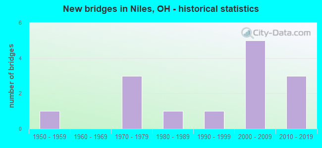
- New bridges - historical statistics
- 11950-1959
- 31970-1979
- 11980-1989
- 11990-1999
- 52000-2009
- 32010-2019
FCC Registered Antenna Towers:
95 (See the full list of FCC Registered Antenna Towers in Niles)FCC Registered Commercial Land Mobile Towers:
4 (See the full list of FCC Registered Commercial Land Mobile Towers in Niles, OH)FCC Registered Private Land Mobile Towers:
1 (See the full list of FCC Registered Private Land Mobile Towers)FCC Registered Broadcast Land Mobile Towers:
12 (See the full list of FCC Registered Broadcast Land Mobile Towers)FCC Registered Microwave Towers:
6 (See the full list of FCC Registered Microwave Towers in this town)FCC Registered Paging Towers:
2 (See the full list of FCC Registered Paging Towers)FCC Registered Amateur Radio Licenses:
84 (See the full list of FCC Registered Amateur Radio Licenses in Niles)FAA Registered Aircraft:
5- Aircraft: DE RUBBA BRADLEY L VANS 7A (Category: Land, Seats: 2, Weight: Up to 12,499 Pounds), Engine: SUPERIOR O-360 (180 HP) (4 Cycle)
N-Number: 522BC, N522BC, N-522BC, Serial Number: 71597, Year manufactured: 2008, Airworthiness Date: 03/26/2009, Certificate Issue Date: 11/13/2008
Registrant (Individual): Bradley L Derubba, 120 N Crandon Ave, Niles, OH 44446 - Aircraft: DASSAULT AVIATION FALCON 2000 (Category: Land, Engines: 2, Seats: 14, Weight: 20,000+ Pounds), Engine: HONEYWELL CFE 738-1-1B (2800 HP) (Turbo-fan)
N-Number: 523WC, N523WC, N-523WC, Serial Number: 212, Year manufactured: 2003, Airworthiness Date: 02/20/2004, Certificate Issue Date: 02/27/2004
Registrant (Corporation): N523wc Ltd, 5577 Youngstown Warren Rd, Niles, OH 44446 - Aircraft: AERONCA 7AC (Category: Land, Seats: 2, Weight: Up to 12,499 Pounds, Speed: 90 mph), Engine: CONT MOTOR A&C65 SERIES (65 HP) (Reciprocating)
N-Number: 83618, N83618, N-83618, Serial Number: 7AC-2295, Year manufactured: 1946, Airworthiness Date: 10/24/1955, Certificate Issue Date: 09/22/2016
Registrant (Individual): Jack B Mcglumphy, 3844 Smith Stewart Rd, Niles, OH 44446 - Aircraft: AERONCA 65-CA (Category: Land, Seats: 2, Weight: Up to 12,499 Pounds, Speed: 75 mph), Engine: CONT MOTOR A&C65 SERIES (65 HP) (Reciprocating)
N-Number: 33843, N33843, N-33843, Serial Number: C13831, Year manufactured: 1941
Registrant (Individual): H F Moore, 11 S Butler St, Niles, OH 44446
Deregistered: Cancel Date: 02/19/2019 - Aircraft: M-SQUARED INC BREEZE 2DS (Category: Land, Seats: 2, Weight: Up to 12,499 Pounds), Engine: ROTAX 582SER (65 HP) (2 Cycle)
N-Number: 71134, N71134, N-71134, Serial Number: 000575, Year manufactured: 2004, Airworthiness Date: 10/15/2007, Certificate Issue Date: 01/19/2016
Registrant (Individual): Eric A Heinselman, 1511 Ravine Ct, Niles, OH 44446
Deregistered: Cancel Date: 05/06/2019
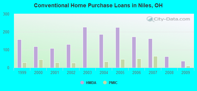
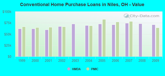
| Home Mortgage Disclosure Act Aggregated Statistics For Year 2009 (Based on 3 full and 2 partial tracts) | ||||||||||
| A) FHA, FSA/RHS & VA Home Purchase Loans | B) Conventional Home Purchase Loans | C) Refinancings | D) Home Improvement Loans | F) Non-occupant Loans on < 5 Family Dwellings (A B C & D) | ||||||
|---|---|---|---|---|---|---|---|---|---|---|
| Number | Average Value | Number | Average Value | Number | Average Value | Number | Average Value | Number | Average Value | |
| LOANS ORIGINATED | 47 | $77,033 | 38 | $71,266 | 186 | $87,315 | 14 | $30,982 | 17 | $56,041 |
| APPLICATIONS APPROVED, NOT ACCEPTED | 2 | $87,885 | 2 | $29,915 | 14 | $78,774 | 5 | $13,430 | 2 | $38,000 |
| APPLICATIONS DENIED | 3 | $75,377 | 8 | $52,919 | 142 | $89,518 | 26 | $35,207 | 11 | $97,725 |
| APPLICATIONS WITHDRAWN | 10 | $54,158 | 6 | $47,458 | 35 | $79,597 | 2 | $14,970 | 4 | $46,575 |
| FILES CLOSED FOR INCOMPLETENESS | 3 | $60,587 | 1 | $45,810 | 6 | $91,365 | 3 | $53,440 | 0 | $0 |
Detailed HMDA statistics for the following Tracts: 9326.00 , 9327.01, 9327.02, 9328.00, 9329.00
| Private Mortgage Insurance Companies Aggregated Statistics For Year 2009 (Based on 3 full and 2 partial tracts) | ||||
| A) Conventional Home Purchase Loans | B) Refinancings | |||
|---|---|---|---|---|
| Number | Average Value | Number | Average Value | |
| LOANS ORIGINATED | 10 | $64,667 | 2 | $152,875 |
| APPLICATIONS APPROVED, NOT ACCEPTED | 2 | $81,065 | 3 | $92,317 |
| APPLICATIONS DENIED | 1 | $38,000 | 2 | $82,820 |
| APPLICATIONS WITHDRAWN | 0 | $0 | 0 | $0 |
| FILES CLOSED FOR INCOMPLETENESS | 0 | $0 | 0 | $0 |
Detailed PMIC statistics for the following Tracts: 9326.00 , 9327.01, 9327.02, 9328.00, 9329.00
2002 - 2018 National Fire Incident Reporting System (NFIRS) incidents
- Fire incident types reported to NFIRS in Niles, OH
- 48946.2%Outside Fires
- 42139.8%Structure Fires
- 13813.0%Mobile Property/Vehicle Fires
- 111.0%Other
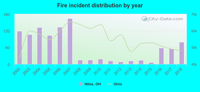 According to the data from the years 2002 - 2018 the average number of fire incidents per year is 62. The highest number of reported fire incidents - 164 took place in 2007, and the least - 7 in 2015. The data has a dropping trend.
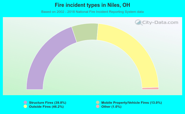 When looking into fire subcategories, the most reports belonged to: Outside Fires (46.2%), and Structure Fires (39.8%).
Fire-safe hotels and motels in Niles, Ohio:
- Residence Inn Niles, 5555 Youngstown-Warren Rd, NILES, Ohio 44446 , Phone: (330) 505-3655, Fax: (330) 505-3650
- Hampton Inn & Suites, 5581 Youngstown Warren Rd, Niles, Ohio 44446 , Phone: (330) 652-1277
| Most common first names in Niles, OH among deceased individuals | ||
| Name | Count | Lived (average) |
|---|---|---|
| John | 333 | 74.1 years |
| Mary | 331 | 80.5 years |
| William | 192 | 75.0 years |
| James | 178 | 73.4 years |
| Joseph | 177 | 73.8 years |
| George | 146 | 74.9 years |
| Robert | 128 | 67.3 years |
| Anna | 127 | 81.5 years |
| Charles | 124 | 73.3 years |
| Frank | 117 | 76.1 years |
| Most common last names in Niles, OH among deceased individuals | ||
| Last name | Count | Lived (average) |
|---|---|---|
| Williams | 79 | 75.5 years |
| Jones | 57 | 75.5 years |
| Smith | 52 | 76.4 years |
| Davis | 48 | 75.5 years |
| Miller | 46 | 73.1 years |
| Brown | 34 | 75.1 years |
| Lewis | 29 | 73.3 years |
| Johnson | 28 | 74.6 years |
| Thomas | 27 | 78.0 years |
| Rose | 27 | 74.2 years |
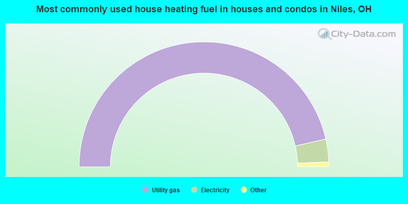
- 93.0%Utility gas
- 5.9%Electricity
- 0.3%Bottled, tank, or LP gas
- 0.3%Other fuel
- 0.2%Wood
- 0.2%No fuel used
- 0.2%Fuel oil, kerosene, etc.
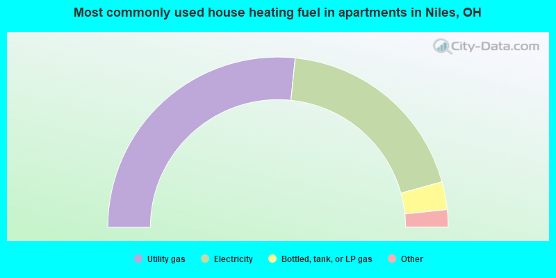
- 53.3%Utility gas
- 38.2%Electricity
- 5.3%Bottled, tank, or LP gas
- 2.5%No fuel used
- 0.8%Other fuel
Niles compared to Ohio state average:
- Median house value below state average.
- Unemployed percentage below state average.
- Black race population percentage significantly below state average.
- Hispanic race population percentage below state average.
- Foreign-born population percentage significantly below state average.
- Length of stay since moving in significantly above state average.
- Number of college students below state average.
Niles on our top lists:
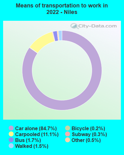
- #96 on the list of "Top 101 cities with the most people driving a car to work alone (population 5,000+)"
- #83 (44446) on the list of "Top 101 zip codes with the largest percentage of Welsh first ancestries (pop 5,000+)"
- #5 on the list of "Top 101 counties with the lowest percentage of residents relocating to foreign countries in 2011"
- #41 on the list of "Top 101 counties with the lowest percentage of residents relocating from foreign countries between 2010 and 2011"
- #65 on the list of "Top 101 counties with the lowest percentage of residents relocating to other counties in 2011"
- #67 on the list of "Top 101 counties with the lowest percentage of residents relocating from other counties between 2010 and 2011"
- #77 on the list of "Top 101 counties with the highest number of deaths per 1000 residents 2007-2013 (pop. 50,000+)"

|
|
Total of 41 patent applications in 2008-2024.