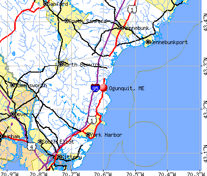
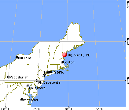
Ogunquit, Maine

Ogunquit: September Blooms, Ogunquit, ME

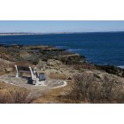
Ogunquit: Moon rising over the ocean

Ogunquit: Footbridge over Ogunquit River

Ogunquit: Street Scene
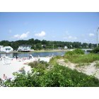
Ogunquit: Ogunquit Beach
Ogunquit: River meets the beach Ogunquit

Ogunquit: Maine, Ogunquit, downtown shops
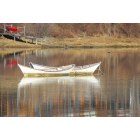
Ogunquit: Ogunquit River title "Just Hanging Out"

Ogunquit: Downtown Ogunquit

Ogunquit: Maine, Ogunquit, Perkins cove, lobster boats
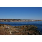
Ogunquit: Ogunquit Beach view from Margial Way
- see
13
more - add
your
Submit your own pictures of this town and show them to the world
- OSM Map
- General Map
- Google Map
- MSN Map
Population change since 2000: -27.2%
| Males: 447 | |
| Females: 445 |
| Median resident age: | 61.7 years |
| Maine median age: | 43.0 years |
Zip codes: 03907.
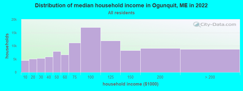
| Ogunquit: | $89,621 |
| ME: | $69,543 |
Estimated per capita income in 2022: $69,757 (it was $34,289 in 2000)
Ogunquit town income, earnings, and wages data
Estimated median house or condo value in 2022: $663,743 (it was $207,800 in 2000)
| Ogunquit: | $663,743 |
| ME: | $290,600 |
Mean prices in 2022: all housing units: $451,552; detached houses: $470,451; townhouses or other attached units: $577,335; in 2-unit structures: $383,179; in 3-to-4-unit structures: $310,696; in 5-or-more-unit structures: $252,113; mobile homes: $105,501
Detailed information about poverty and poor residents in Ogunquit, ME


- 85996.3%White alone
- 131.5%Hispanic
- 91.0%Asian alone
- 91.0%Two or more races
- 10.1%American Indian alone
- 10.1%Other race alone
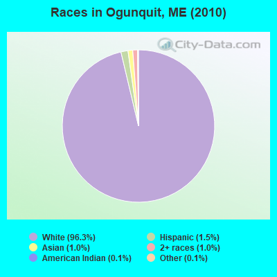
Races in Ogunquit detailed stats: ancestries, foreign born residents, place of birth
According to our research of Maine and other state lists, there was 1 registered sex offender living in Ogunquit, Maine as of April 28, 2024.
The ratio of all residents to sex offenders in Ogunquit is 892 to 1.
The ratio of registered sex offenders to all residents in this city is lower than the state average.
Type |
2009 |
2010 |
2011 |
2012 |
2013 |
2014 |
2015 |
2016 |
2017 |
2018 |
2019 |
2020 |
2021 |
2022 |
|---|---|---|---|---|---|---|---|---|---|---|---|---|---|---|
| Murders (per 100,000) | 0 (0.0) | 0 (0.0) | 0 (0.0) | 0 (0.0) | 0 (0.0) | 0 (0.0) | 0 (0.0) | 0 (0.0) | 0 (0.0) | 0 (0.0) | 0 (0.0) | 0 (0.0) | 0 (0.0) | 0 (0.0) |
| Rapes (per 100,000) | 0 (0.0) | 0 (0.0) | 0 (0.0) | 0 (0.0) | 0 (0.0) | 0 (0.0) | 0 (0.0) | 0 (0.0) | 1 (108.5) | 0 (0.0) | 0 (0.0) | 0 (0.0) | 1 (106.6) | 0 (0.0) |
| Robberies (per 100,000) | 0 (0.0) | 0 (0.0) | 0 (0.0) | 0 (0.0) | 0 (0.0) | 0 (0.0) | 0 (0.0) | 0 (0.0) | 0 (0.0) | 0 (0.0) | 0 (0.0) | 0 (0.0) | 0 (0.0) | 0 (0.0) |
| Assaults (per 100,000) | 2 (158.0) | 0 (0.0) | 0 (0.0) | 0 (0.0) | 1 (110.5) | 2 (219.5) | 2 (218.1) | 3 (327.5) | 0 (0.0) | 0 (0.0) | 0 (0.0) | 2 (214.6) | 1 (106.6) | 0 (0.0) |
| Burglaries (per 100,000) | 11 (868.9) | 4 (448.4) | 8 (896.9) | 18 (2,004) | 5 (552.5) | 3 (329.3) | 4 (436.2) | 4 (436.7) | 3 (325.4) | 5 (540.5) | 1 (107.4) | 3 (321.9) | 0 (0.0) | 1 (62.4) |
| Thefts (per 100,000) | 28 (2,212) | 33 (3,700) | 18 (2,018) | 37 (4,120) | 33 (3,646) | 26 (2,854) | 25 (2,726) | 13 (1,419) | 30 (3,254) | 19 (2,054) | 25 (2,685) | 18 (1,931) | 19 (2,026) | 17 (1,061) |
| Auto thefts (per 100,000) | 0 (0.0) | 0 (0.0) | 0 (0.0) | 1 (111.4) | 0 (0.0) | 1 (109.8) | 0 (0.0) | 0 (0.0) | 0 (0.0) | 0 (0.0) | 1 (107.4) | 0 (0.0) | 2 (213.2) | 2 (124.8) |
| Arson (per 100,000) | 0 (0.0) | 0 (0.0) | 0 (0.0) | 0 (0.0) | 0 (0.0) | 0 (0.0) | 0 (0.0) | 0 (0.0) | 0 (0.0) | 0 (0.0) | 0 (0.0) | 0 (0.0) | 0 (0.0) | 0 (0.0) |
| City-Data.com crime index | 180.9 | 179.4 | 143.5 | 314.0 | 206.6 | 189.9 | 183.2 | 152.8 | 239.7 | 120.0 | 123.5 | 142.7 | 204.7 | 56.8 |
The City-Data.com crime index weighs serious crimes and violent crimes more heavily. Higher means more crime, U.S. average is 246.1. It adjusts for the number of visitors and daily workers commuting into cities.
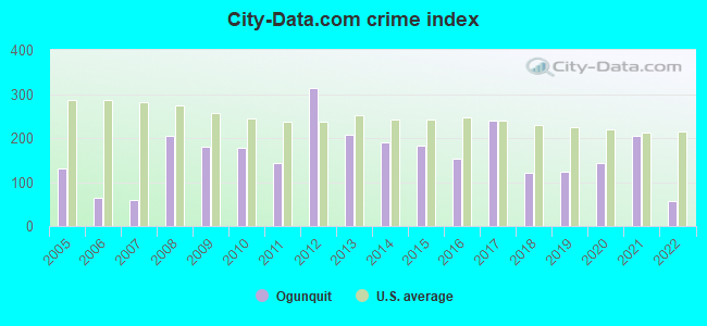
Crime rate in Ogunquit detailed stats: murders, rapes, robberies, assaults, burglaries, thefts, arson
Full-time law enforcement employees in 2021, including police officers: 12 (11 officers - 10 male; 1 female).
| Officers per 1,000 residents here: | 11.73 |
| Maine average: | 1.71 |
 Recent articles from our blog. Our writers, many of them Ph.D. graduates or candidates, create easy-to-read articles on a wide variety of topics.

 | Photos of Maine (4586 replies) |
| Ogunquit - best month to visit (5 replies) |
| Lighthouse tours in southern Maine? (7 replies) |
| Ogunquit/Wells fried clams/oyster poll (0 replies) |
| Bethel Maine Fisherman Lands a 50-inch Striped Bass (2 replies) |
| Maine for a week - what else to do? (58 replies) |
Latest news from Ogunquit, ME collected exclusively by city-data.com from local newspapers, TV, and radio stations
Ogunquit, ME City Guides:
Ancestries: English (24.6%), Irish (17.1%), Italian (11.5%), German (9.5%), French (7.0%), French Canadian (6.6%).
Current Local Time: EST time zone
Incorporated on 07/01/1980
Elevation: 50 feet
Land area: 4.10 square miles.
Population density: 218 people per square mile (very low).
71 residents are foreign born (2.9% Europe, 2.5% North America).
| This town: | 5.8% |
| Maine: | 2.9% |
| Ogunquit town: | 1.1% ($2,349) |
| Maine: | 1.5% ($1,417) |
Nearest city with pop. 50,000+: Portland, ME  (33.1 miles , pop. 64,249).
Nearest city with pop. 200,000+: Boston, MA (68.9 miles , pop. 589,141).
Nearest city with pop. 1,000,000+: Bronx, NY (236.4 miles , pop. 1,332,650).
Nearest cities:
), Latitude: 43.25 N, Longitude: 70.60 W
Area code commonly used in this area: 207

Ogunquit tourist attractions:
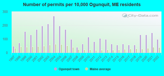
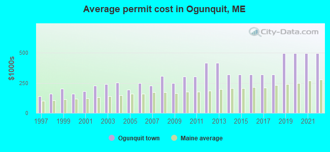
Single-family new house construction building permits:
- 2022: 12 buildings, average cost: $497,900
- 2021: 18 buildings, average cost: $497,900
- 2020: 16 buildings, average cost: $497,900
- 2019: 16 buildings, average cost: $497,900
- 2018: 7 buildings, average cost: $319,000
- 2017: 7 buildings, average cost: $319,000
- 2016: 8 buildings, average cost: $319,000
- 2015: 7 buildings, average cost: $319,000
- 2014: 8 buildings, average cost: $319,000
- 2013: 12 buildings, average cost: $418,700
- 2012: 13 buildings, average cost: $418,700
- 2011: 10 buildings, average cost: $303,500
- 2010: 14 buildings, average cost: $303,500
- 2009: 8 buildings, average cost: $246,600
- 2008: 5 buildings, average cost: $306,300
- 2007: 12 buildings, average cost: $227,000
- 2006: 21 buildings, average cost: $250,200
- 2005: 24 buildings, average cost: $193,700
- 2004: 33 buildings, average cost: $253,100
- 2003: 26 buildings, average cost: $240,200
- 2002: 24 buildings, average cost: $226,800
- 2001: 21 buildings, average cost: $183,000
- 2000: 16 buildings, average cost: $157,600
- 1999: 19 buildings, average cost: $201,900
- 1998: 9 buildings, average cost: $159,900
- 1997: 6 buildings, average cost: $139,000
| Here: | 5.8% |
| Maine: | 3.4% |

- Accommodation & food services (17.3%)
- Educational services (9.2%)
- Health care (7.9%)
- Professional, scientific, technical services (7.4%)
- Construction (5.2%)
- Public administration (4.0%)
- Arts, entertainment, recreation (3.8%)
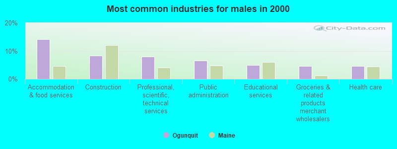
- Accommodation & food services (14.2%)
- Construction (8.3%)
- Professional, scientific, technical services (8.0%)
- Public administration (6.5%)
- Educational services (4.9%)
- Groceries & related products merchant wholesalers (4.6%)
- Health care (4.6%)
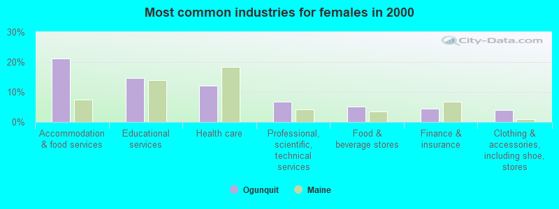
- Accommodation & food services (21.3%)
- Educational services (14.6%)
- Health care (12.2%)
- Professional, scientific, technical services (6.7%)
- Food & beverage stores (5.1%)
- Finance & insurance (4.3%)
- Clothing & accessories, including shoe, stores (3.9%)

- Other management occupations, except farmers and farm managers (13.0%)
- Retail sales workers, except cashiers (5.2%)
- Other production occupations, including supervisors (4.0%)
- Other sales and related occupations, including supervisors (3.6%)
- Information and record clerks, except customer service representatives (3.6%)
- Registered nurses (3.5%)
- Sales representatives, services, wholesale and manufacturing (3.3%)

- Other management occupations, except farmers and farm managers (15.1%)
- Sales representatives, services, wholesale and manufacturing (4.6%)
- Retail sales workers, except cashiers (4.3%)
- Other production occupations, including supervisors (4.3%)
- Advertising, marketing, promotions, public relations, and sales managers (3.7%)
- Other sales and related occupations, including supervisors (3.7%)
- Engineers (3.4%)

- Other management occupations, except farmers and farm managers (10.2%)
- Registered nurses (7.9%)
- Information and record clerks, except customer service representatives (6.3%)
- Retail sales workers, except cashiers (6.3%)
- Cashiers (5.9%)
- Waiters and waitresses (5.1%)
- Secretaries and administrative assistants (4.7%)
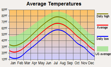
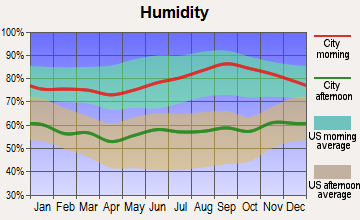
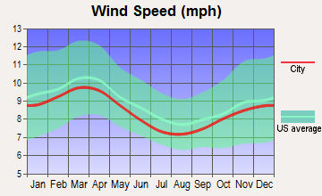
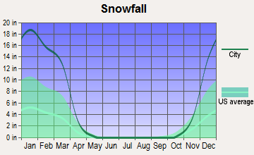
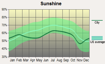
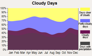
Average climate in Ogunquit, Maine
Based on data reported by over 4,000 weather stations
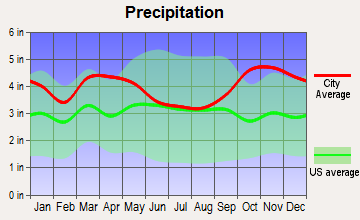
(lower is better)
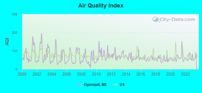
Air Quality Index (AQI) level in 2022 was 61.4. This is about average.
| City: | 61.4 |
| U.S.: | 72.6 |
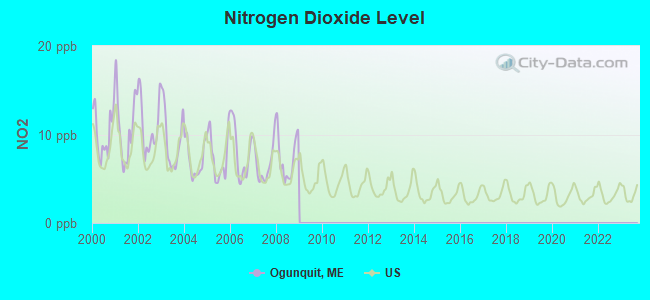
Nitrogen Dioxide (NO2) [ppb] level in 2008 was 7.38. This is significantly worse than average. Closest monitor was 9.1 miles away from the city center.
| City: | 7.38 |
| U.S.: | 5.11 |
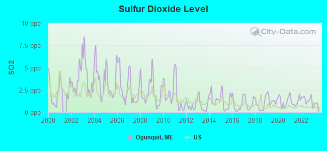
Sulfur Dioxide (SO2) [ppb] level in 2022 was 1.48. This is about average. Closest monitor was 12.0 miles away from the city center.
| City: | 1.48 |
| U.S.: | 1.51 |
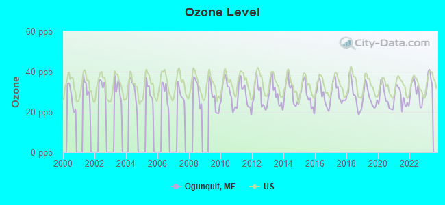
Ozone [ppb] level in 2022 was 29.7. This is about average. Closest monitor was 5.8 miles away from the city center.
| City: | 29.7 |
| U.S.: | 33.3 |
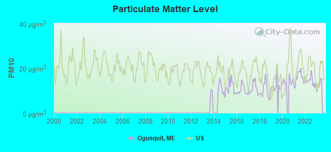
Particulate Matter (PM10) [µg/m3] level in 2022 was 14.4. This is better than average. Closest monitor was 14.3 miles away from the city center.
| City: | 14.4 |
| U.S.: | 19.2 |
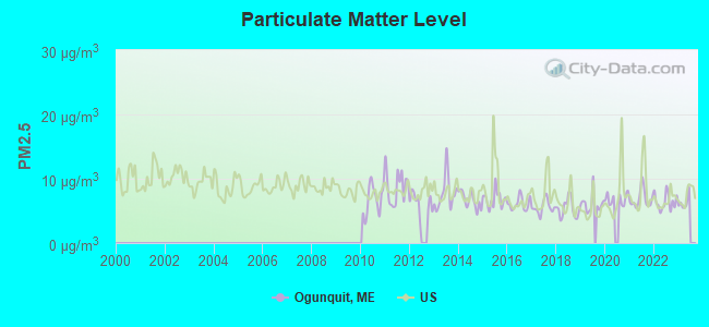
Particulate Matter (PM2.5) [µg/m3] level in 2022 was 6.41. This is better than average. Closest monitor was 14.3 miles away from the city center.
| City: | 6.41 |
| U.S.: | 8.11 |
Tornado activity:
Ogunquit-area historical tornado activity is significantly above Maine state average. It is 66% smaller than the overall U.S. average.
On 6/9/1953, a category F3 (max. wind speeds 158-206 mph) tornado 27.0 miles away from the Ogunquit town center injured 5 people and caused between $5000 and $50,000 in damages.
On 5/14/1963, a category F2 (max. wind speeds 113-157 mph) tornado 11.7 miles away from the town center caused between $5000 and $50,000 in damages.
Earthquake activity:
Ogunquit-area historical earthquake activity is significantly above Maine state average. It is 74% smaller than the overall U.S. average.On 10/16/2012 at 23:12:25, a magnitude 4.7 (4.7 ML, Depth: 10.0 mi, Class: Light, Intensity: IV - V) earthquake occurred 24.2 miles away from Ogunquit center
On 4/20/2002 at 10:50:47, a magnitude 5.3 (5.3 ML, Depth: 3.0 mi, Class: Moderate, Intensity: VI - VII) earthquake occurred 177.4 miles away from the city center
On 1/19/1982 at 00:14:42, a magnitude 4.7 (4.5 MB, 4.7 MD, 4.5 LG) earthquake occurred 53.2 miles away from the city center
On 10/7/1983 at 10:18:46, a magnitude 5.3 (5.1 MB, 5.3 LG, 5.1 ML) earthquake occurred 193.7 miles away from the city center
On 4/20/2002 at 10:50:47, a magnitude 5.2 (5.2 MB, 4.2 MS, 5.2 MW, 5.0 MW) earthquake occurred 177.5 miles away from Ogunquit center
On 8/21/1996 at 07:54:14, a magnitude 3.8 (3.8 LG, 3.6 LG, Depth: 6.2 mi, Class: Light, Intensity: II - III) earthquake occurred 74.8 miles away from the city center
Magnitude types: regional Lg-wave magnitude (LG), body-wave magnitude (MB), duration magnitude (MD), local magnitude (ML), surface-wave magnitude (MS), moment magnitude (MW)
Natural disasters:
The number of natural disasters in York County (31) is a lot greater than the US average (15).Major Disasters (Presidential) Declared: 23
Emergencies Declared: 8
Causes of natural disasters: Floods: 21, Storms: 16, Winter Storms: 6, Snows: 5, Winds: 3, Heavy Rains: 2, Hurricanes: 2, Blizzard: 1, Ice Storm: 1, Mudslide: 1, Snowfall: 1, Snowstorm: 1, Tornado: 1, Tropical Storm: 1 (Note: some incidents may be assigned to more than one category).
Hospitals and medical centers near Ogunquit:
- YORK HOSPITAL HOME CARE (Home Health Center, about 8 miles away; YORK, ME)
- YORK HOSPITAL Acute Care Hospitals (about 8 miles away; YORK, ME)
- YORK HOSPITAL STRATER UNIT (Nursing Home, about 8 miles away; YORK, ME)
- VARNEY CROSSING NCC (Nursing Home, about 9 miles away; NORTH BERWICK, ME)
- YORK HARBOR HEALTH CARE (Nursing Home, about 9 miles away; YORK, ME)
- BEACON HOSPICE (Hospital, about 9 miles away; YORK, ME)
- GREENWOOD CENTER (Nursing Home, about 11 miles away; SANFORD, ME)
Colleges/universities with over 2000 students nearest to Ogunquit:
- University of New England (about 18 miles; Biddeford, ME; Full-time enrollment: 4,539)
- University of New Hampshire-Main Campus (about 19 miles; Durham, NH; FT enrollment: 15,243)
- University of Southern Maine (about 33 miles; Portland, ME; FT enrollment: 6,647)
- Southern Maine Community College (about 34 miles; South Portland, ME; FT enrollment: 4,666)
- Northern Essex Community College (about 39 miles; Haverhill, MA; FT enrollment: 4,737)
- Saint Joseph's College of Maine (about 41 miles; Standish, ME; FT enrollment: 2,010)
- Southern New Hampshire University (about 46 miles; Manchester, NH; FT enrollment: 16,552)
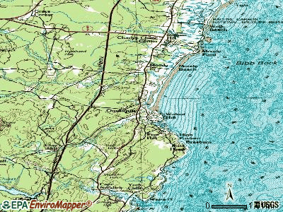
Points of interest:
Notable locations in Ogunquit: Pinderosa Campground (A), Ogunquit Fire and Rescue (B), S Judson Dunaway Center (C), Ogunquit Playhouse (D), Ogunquit Museum of American Art (E), Ogunquit Memorial Library (F), Ogunquit Information Bureau (G), Ogunquit Art Association Gallery (H). Display/hide their locations on the map
Shopping Center: The Blacksmith Mall Shopping Center (1). Display/hide its location on the map
Churches in Ogunquit include: Ogunquit United Methodist Church (A), Ogunquit Baptist Church (B), All Saints Catholic Church (C). Display/hide their locations on the map
Lake: Staples Pond (A). Display/hide its location on the map
Streams, rivers, and creeks: Josias River (A), Green Brook (B). Display/hide their locations on the map
Beaches: Footbridge Beach (A), Ogunquit Beach (B). Display/hide their locations on the map
Tourist attractions: Ogunquit Town of Winn House (Cultural Attractions- Events- & Facilities; 86 Obeds Lane), Ugly Anne (Tours & Charters; 254 Captain Thomas Road).
Hotels: Admiral's Inn The (87 Main St), Riverside Motel (Perkins Cove Road), Cliff House Resort & Spa (Bald Head Cliff), Hillcrest Inn Resort (512 Shore Road), Pink Blossoms Family Resort (214 Shore Road), Seacastles Resort & Suites (104 Shore Road), The Milestone (687 Main Street), Leisure Inn (6 School), Bayberry (50 Shore Road).
Drinking water stations with addresses in Ogunquit and their reported violations in the past:
CLAY HILL FARM (Population served: 200, Groundwater):Past health violations:SPARHAWK RESORT (Population served: 178, Groundwater):Past monitoring violations:
- MCL, Monthly (TCR) - In JUL-2009, Contaminant: Coliform. Follow-up actions: St Public Notif requested (JUL-31-2009), St Formal NOV issued (JUL-31-2009), St Public Notif received (AUG-26-2009), St Compliance achieved (MAR-31-2010)
- 5 routine major monitoring violations
- 2 regular monitoring violations
Past monitoring violations:THE DUNES INC (Population served: 76, Groundwater):
- One routine major monitoring violation
Past monitoring violations:
- 2 routine major monitoring violations
| This town: | 1.8 people |
| Maine: | 2.3 people |
| This town: | 47.0% |
| Whole state: | 62.9% |
| This town: | 9.0% |
| Whole state: | 9.4% |
Likely homosexual households (counted as self-reported same-sex unmarried-partner households)
- Lesbian couples: 1.0% of all households
- Gay men: 4.0% of all households
| This town: | 4.2% |
| Whole state: | 10.9% |
| This town: | 1.8% |
| Whole state: | 4.1% |
Banks with branches in Ogunquit (2011 data):
- Kennebunk Savings Bank: Ogunquit Branch at 25 South Main Street, branch established on 1983/04/15. Info updated 2010/05/27: Bank assets: $821.4 mil, Deposits: $660.6 mil, headquarters in Kennebunk, ME, positive income, Commercial Lending Specialization, 15 total offices
- KeyBank National Association: Ogunquit Branch at 251 Main Street, branch established on 1972/06/01. Info updated 2008/03/03: Bank assets: $86,198.8 mil, Deposits: $64,214.8 mil, headquarters in Cleveland, OH, positive income, Commercial Lending Specialization, 1067 total offices, Holding Company: Keycorp
For population 15 years and over in Ogunquit:
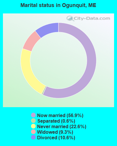
- Never married: 22.6%
- Now married: 56.9%
- Separated: 0.6%
- Widowed: 9.3%
- Divorced: 10.6%
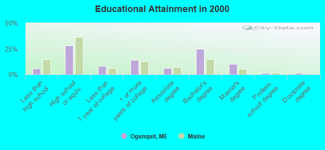
For population 25 years and over in Ogunquit:
- High school or higher: 94.2%
- Bachelor's degree or higher: 37.3%
- Graduate or professional degree: 12.7%
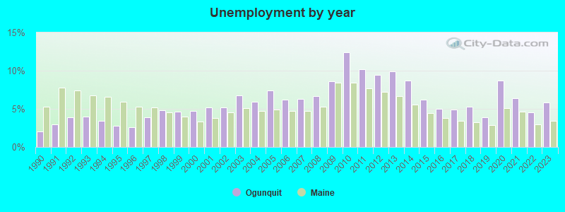
- Unemployed: 4.1%
- Mean travel time to work (commute): 29.3 minutes
| Here: | 9.5 |
| Maine average: | 11.2 |


Graphs represent county-level data. Detailed 2008 Election Results
Religion statistics for Ogunquit, ME (based on York County data)
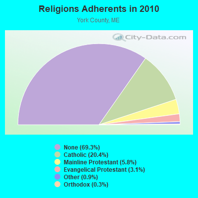

| Religion | Adherents | Congregations |
|---|---|---|
| Catholic | 40,283 | 16 |
| Mainline Protestant | 11,480 | 64 |
| Evangelical Protestant | 6,086 | 51 |
| Other | 1,847 | 18 |
| Orthodox | 625 | 3 |
| Black Protestant | 119 | 1 |
| None | 136,691 | - |
Food Environment Statistics:
| This county: | 2.24 / 10,000 pop. |
| Maine: | 2.80 / 10,000 pop. |
| Here: | 0.05 / 10,000 pop. |
| State: | 0.14 / 10,000 pop. |
| York County: | 2.09 / 10,000 pop. |
| Maine: | 2.20 / 10,000 pop. |
| York County: | 4.23 / 10,000 pop. |
| Maine: | 5.75 / 10,000 pop. |
| York County: | 12.53 / 10,000 pop. |
| Maine: | 11.02 / 10,000 pop. |
| York County: | 7.7% |
| Maine: | 8.2% |
| York County: | 24.0% |
| Maine: | 25.0% |
Businesses in Ogunquit, ME
- Ben & Jerry's: 1
Strongest AM radio stations in Ogunquit:
- WGIN (930 AM; 10 kW; ROCHESTER, NH; Owner: CAPSTAR TX LIMITED PARTNERSHIP)
- WTSN (1270 AM; 5 kW; DOVER, NH; Owner: GARRISON CITY BROADCASTING, INC.)
- WRKO (680 AM; 50 kW; BOSTON, MA; Owner: ENTERCOM BOSTON LICENSE, LLC)
- WMTW (870 AM; 10 kW; GORHAM, ME; Owner: RADIO PARTNERS OF MAINE, L.P.)
- WBZ (1030 AM; 50 kW; BOSTON, MA; Owner: INFINITY BROADCASTING OPERATIONS, INC.)
- WEEI (850 AM; 50 kW; BOSTON, MA; Owner: ENTERCOM BOSTON LICENSE, LLC)
- WWZN (1510 AM; 50 kW; BOSTON, MA; Owner: ROSE CITY RADIO CORPORATION)
- WGAN (560 AM; 5 kW; PORTLAND, ME; Owner: SAGA COMMUNICATIONS OF NEW ENGLAND, LLC)
- WKOX (1200 AM; 50 kW; FRAMINGHAM, MA; Owner: CAPSTAR TX LIMITED PARTNERSHIP)
- WZAN (970 AM; 5 kW; PORTLAND, ME; Owner: SAGA COMMUNICATIONS OF NEW ENGLAND, LLC)
- WCRN (830 AM; 50 kW; WORCESTER, MA; Owner: CARTER BROADCASTING CORPORATION)
- WBIX (1060 AM; 40 kW; NATICK, MA; Owner: LANGER BROADCASTING CORPORATION)
- WGIP (1540 AM; 5 kW; EXETER, NH; Owner: CAPSTAR TX LIMITED PARTNERSHIP)
Strongest FM radio stations in Ogunquit:
- WUBB (95.3 FM; YORK CENTER, ME; Owner: CAPSTAR TX LIMITED PARTNERSHIP)
- WPHX-FM (92.1 FM; SANFORD, ME; Owner: FNX BROADCASTING LLC)
- WSEW (88.5 FM; SANFORD, ME; Owner: WORD RADIO EDUCATIONAL FOUNDATION)
- WSHK (105.3 FM; KITTERY, ME; Owner: CITADEL BROADCASTING COMPANY)
- WMEA (90.1 FM; PORTLAND, ME; Owner: MAINE PUBLIC BROADCASTING CORPORATION)
- WPKQ (103.7 FM; NORTH CONWAY, NH; Owner: CITADEL BROADCASTING COMPANY)
- WHEB (100.3 FM; PORTSMOUTH, NH; Owner: CAPSTAR TX LIMITED PARTNERSHIP)
- WHOM (94.9 FM; MT. WASHINGTON, NH; Owner: CITADEL BROADCASTING COMPANY)
- WSCY (106.9 FM; MOULTONBOROUGH, NH; Owner: NORTHEAST COMMUNICATIONS CORPORATION)
- WQEZ (104.7 FM; KENNEBUNKPORT, ME; Owner: MARINER BROADCASTING L.P.)
- WBQQ (99.3 FM; KENNEBUNK, ME; Owner: MARINER BROADCASTING L.P.)
- WOKQ (97.5 FM; DOVER, NH; Owner: CITADEL BROADCASTING COMPANY)
- WBYY (98.7 FM; SOMERSWORTH, NH; Owner: GARRISON CITY BROADCASTING, INC.)
- WBLM (102.9 FM; PORTLAND, ME; Owner: CITADEL BROADCASTING COMPANY)
- WMEX (106.5 FM; FARMINGTON, NH; Owner: WIMMEX, LLC)
- WCYY (94.3 FM; BIDDEFORD, ME; Owner: CITADEL BROADCASTING COMPANY)
- WQSO (96.7 FM; ROCHESTER, NH; Owner: CAPSTAR TX LIMITED PARTNERSHIP)
- WRED (95.9 FM; SACO, ME; Owner: ATLANTIC COAST RADIO, LLC)
- WLKZ (104.9 FM; WOLFEBORO, NH; Owner: TELE-MEDIA COMPANY OF NEW HAMPSHIRE, L.L.C.)
- WERZ (107.1 FM; EXETER, NH; Owner: CAPSTAR TX LIMITED PARTNERSHIP)
TV broadcast stations around Ogunquit:
- WMEA-TV (Channel 26; BIDDEFORD, ME; Owner: MAINE PUBLIC BROADCASTING CORP.)
- WMTW-TV (Channel 8; POLAND SPRING, ME; Owner: WMTW BROADCAST GROUP, LLC)
- WHDN-LP (Channel 26; BOSTON, MA; Owner: GUENTER MARKSTEINER)
- WGME-TV (Channel 13; PORTLAND, ME; Owner: WGME LICENSEE, LLC)
- WCSH (Channel 6; PORTLAND, ME; Owner: PACIFIC AND SOUTHERN COMPANY, INC.)
- Ogunquit, Maine
- Fatal accident count14
- Vehicles involved in fatal accidents17
- Fatal accidents involving drunk persons:6
- Fatalities17
- Persons involved in fatal accidents39
- Pedestrians involved in fatal accidents2
- Maine average
- Fatal accident count1982
- Vehicles involved in fatal accidents2797
- Fatal accidents involving drunk persons827
- Fatalities2209
- Persons involved in fatal accidents4790
- Pedestrians involved in fatal accidents125
- National Bridge Inventory (NBI) Statistics
- 18Number of bridges
- 709ft / 216mTotal length
- 195,118Total average daily traffic
- 12,383Total average daily truck traffic
- 273,220Total future (year 2036) average daily traffic
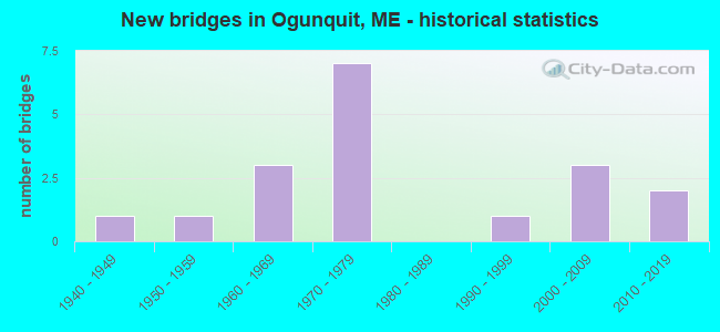
- New bridges - historical statistics
- 11940-1949
- 11950-1959
- 31960-1969
- 71970-1979
- 11990-1999
- 32000-2009
- 22010-2019
FCC Registered Broadcast Land Mobile Towers:
3- Town Ofc School St (Lat: 43.250083 Lon: -70.598111), Call Sign: KNAR511,
Assigned Frequencies: 155.040 MHz, Grant Date: 01/05/2011, Expiration Date: 01/04/2021, Cancellation Date: 04/17/2012, Registrant: Business Radio Licensing, 30251 Golden Lantern, Suite E #501, Laguna Niguel, CA 92677, Phone: (949) 348-8510, Fax: (949) 348-8514, Email:
- Twn Off School St (Lat: 43.250083 Lon: -70.598111), Call Sign: WAM974, Licensee ID: L00022547,
Assigned Frequencies: 154.770 MHz, Grant Date: 12/23/2004, Expiration Date: 02/01/2015, Cancellation Date: 04/04/2015, Registrant: Ogunquit Police Department, 20 Cottage Street, Ogunquit, ME 03907, Phone: (207) 646-9362
- 8 Shore Road (Lat: 43.248528 Lon: -70.599806), Call Sign: WQUM653, Licensee ID: L01885524,
Assigned Frequencies: 462.362 MHz, 467.362 MHz, 462.312 MHz, 467.312 MHz, Grant Date: 08/19/2014, Expiration Date: 08/19/2024, Certifier: James A Oliver, Registrant: Bessie\'s Inc., 8 Shore Rd, Ogunquit, ME 03907-0895, Phone: (207) 646-0888, Email:
FCC Registered Maritime Coast & Aviation Ground Towers:
1- 31 Frazier Pasture Rd (Lat: 43.247583 Lon: -70.594222), Type: Building, Overall height: 9 m, Call Sign: WHV225,
Assigned Frequencies: 156.450 MHz, 156.475 MHz, 2.09790 MHz, 156.800 MHz, 2.18340 MHz, 156.900 MHz, 4.12640 MHz, 6.22540 MHz, 8.29240 MHz, 12.3544 MHz, 16.5294 MHz, 22.1604 MHz, Grant Date: 02/04/2022, Expiration Date: 04/17/2032, Registrant: Bunny Clark, Corp., 93 Frazier Pasture Rd, Ogunquit, ME 03907, Phone: (207) 251-2214, Fax: (207) 646-1219, Email:
FCC Registered Amateur Radio Licenses:
15 (See the full list of FCC Registered Amateur Radio Licenses in Ogunquit)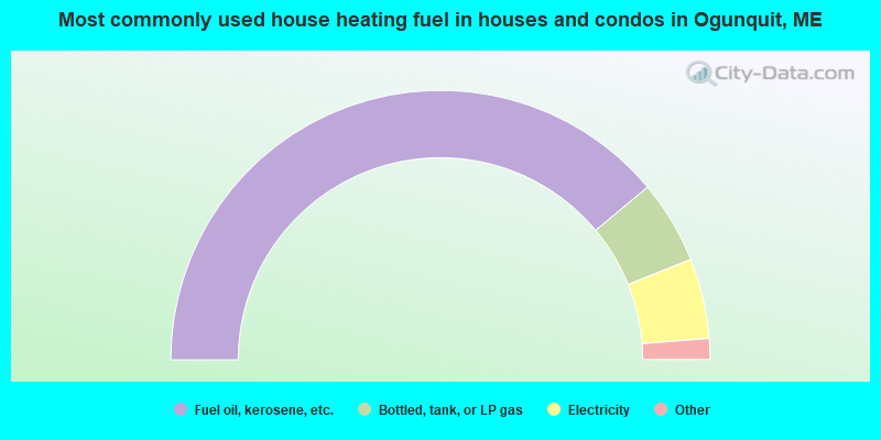
- 77.8%Fuel oil, kerosene, etc.
- 10.0%Bottled, tank, or LP gas
- 9.6%Electricity
- 1.7%Wood
- 0.4%Utility gas
- 0.4%Other fuel
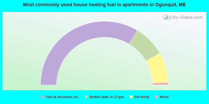
- 67.1%Fuel oil, kerosene, etc.
- 16.1%Bottled, tank, or LP gas
- 15.4%Electricity
- 1.3%Wood
Ogunquit compared to Maine state average:
- Median house value significantly above state average.
- Unemployed percentage significantly below state average.
- Black race population percentage significantly below state average.
- Hispanic race population percentage below state average.
- Median age significantly above state average.
- Foreign-born population percentage above state average.
- Renting percentage below state average.
- Length of stay since moving in significantly above state average.
- Number of rooms per house significantly below state average.
- House age significantly below state average.

|
Total of 2 patent applications in 2008-2024.