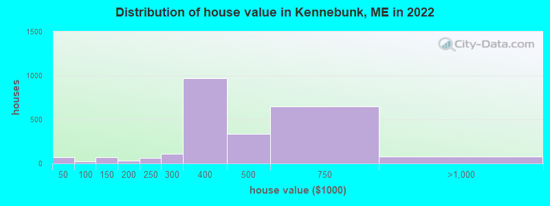
Estimated median house or condo value in 2022: $429,722 (it was $143,400 in 2000)
Kennebunk:
$429,722
ME:
$290,600
Mean prices in 2022:all housing units: $430,875; detached houses: $422,385; townhouses or other attached units: $597,496; in 2-unit structures: $385,644; in 3-to-4-unit structures: $259,286; in 5-or-more-unit structures: $340,173
Median gross rent in 2022: $1,131.
March 2022 cost of living index in Kennebunk: 111.8 (more than average, U.S. average is 100)
According to our research of Maine and other state lists, there were 5 registered sex offenders living in Kennebunk, Maine as of April 27, 2024. The ratio of all residents to sex offenders in Kennebunk is 1,117 to 1. The ratio of registered sex offenders to all residents in this city is lower than the state average.
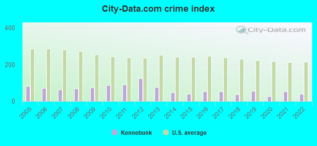
Crime rates in Kennebunk by year
Type
2009
2010
2011
2012
2013
2014
2015
2016
2017
2018
2019
2020
2021
2022
Murders (per 100,000)
0 (0.0)
0 (0.0)
0 (0.0)
0 (0.0)
0 (0.0)
0 (0.0)
0 (0.0)
0 (0.0)
0 (0.0)
0 (0.0)
0 (0.0)
0 (0.0)
0 (0.0)
0 (0.0)
Rapes (per 100,000)
1 (8.7)
3 (27.8)
2 (18.5)
7 (64.4)
1 (9.1)
1 (9.0)
0 (0.0)
2 (17.7)
4 (35.1)
1 (8.7)
4 (34.4)
1 (8.5)
5 (42.4)
2 (16.9)
Robberies (per 100,000)
1 (8.7)
0 (0.0)
1 (9.3)
0 (0.0)
1 (9.1)
0 (0.0)
0 (0.0)
1 (8.9)
0 (0.0)
1 (8.7)
0 (0.0)
0 (0.0)
0 (0.0)
0 (0.0)
Assaults (per 100,000)
1 (8.7)
1 (9.3)
2 (18.5)
3 (27.6)
5 (45.4)
5 (45.1)
4 (35.8)
1 (8.9)
3 (26.3)
4 (34.9)
6 (51.6)
0 (0.0)
1 (8.5)
1 (8.5)
Burglaries (per 100,000)
42 (363.6)
38 (351.9)
46 (426.0)
43 (395.8)
30 (272.2)
18 (162.2)
13 (116.2)
11 (97.4)
6 (52.6)
9 (78.5)
2 (17.2)
0 (0.0)
1 (8.5)
11 (93.2)
Thefts (per 100,000)
104 (900.4)
102 (944.6)
104 (963.2)
111 (1,022)
102 (925.3)
52 (468.7)
62 (554.3)
77 (682.1)
38 (333.2)
43 (375.1)
43 (370.0)
49 (418.1)
51 (432.2)
51 (432.1)
Auto thefts (per 100,000)
3 (26.0)
1 (9.3)
0 (0.0)
1 (9.2)
2 (18.1)
2 (18.0)
2 (17.9)
1 (8.9)
2 (17.5)
1 (8.7)
1 (8.6)
4 (34.1)
1 (8.5)
1 (8.5)
Arson (per 100,000)
1 (8.7)
1 (9.3)
2 (18.5)
0 (0.0)
0 (0.0)
0 (0.0)
0 (0.0)
0 (0.0)
0 (0.0)
0 (0.0)
1 (8.6)
0 (0.0)
0 (0.0)
0 (0.0)
City-Data.com crime index
74.8
87.2
89.7
126.4
76.6
47.8
38.9
53.4
51.7
37.8
54.6
26.3
54.2
39.7
The City-Data.com crime index weighs serious crimes and violent crimes more heavily. Higher means more crime, U.S. average is 246.1. It adjusts for the number of visitors and daily workers commuting into cities.
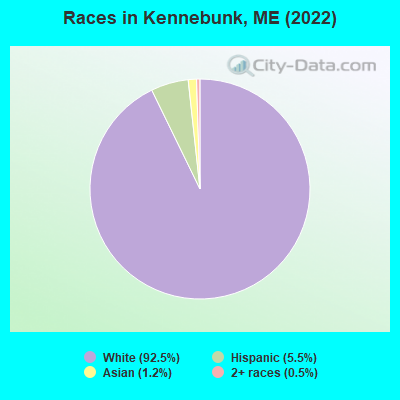
Ancestries: Irish (15.9%), English (13.6%), American (8.7%), French Canadian (7.3%), German (6.4%), French (6.0%).
Current Local Time: EST time zone
Incorporated on 07/31/1820
Elevation: 65 feet
Land area: 6.74 square miles.
Population density: 773 people per square mile (low).
465 residents are foreign born (3.8% Asia, 1.9% Europe, 1.4% Latin America).
This place:
7.6%
Maine:
3.8%
Median real estate property taxes paid for housing units with mortgages in 2022: $4,442 (1.0%) Median real estate property taxes paid for housing units with no mortgage in 2022: $4,522 (1.1%)
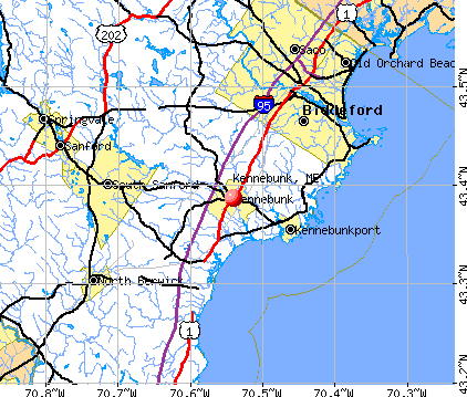
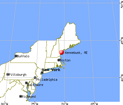
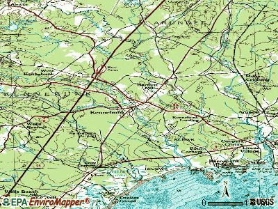
Nearest city with pop. 50,000+: Portland, ME (23.6 miles , pop. 64,249).
Nearest city with pop. 200,000+: Boston, MA (78.7 miles , pop. 589,141).
Nearest city with pop. 1,000,000+: Bronx, NY (245.1 miles , pop. 1,332,650).
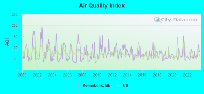
Air Quality Index (AQI) level in 2023 was 73.4. This is about average.
City:
73.4
U.S.:
72.6
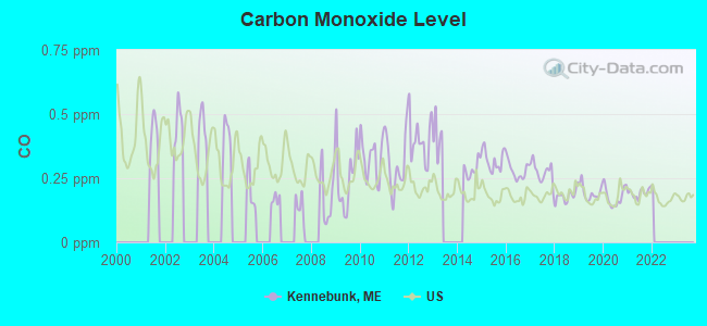
Carbon Monoxide (CO) [ppm] level in 2021 was 0.192. This is better than average.Closest monitor was 20.6 miles away from the city center.
City:
0.192
U.S.:
0.251
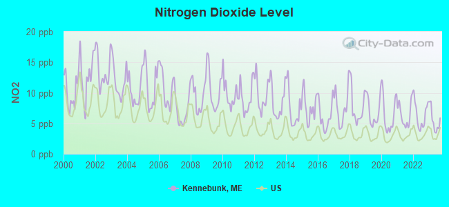
Nitrogen Dioxide (NO2) [ppb] level in 2023 was 5.47. This is about average.Closest monitor was 4.6 miles away from the city center.
City:
5.47
U.S.:
5.11
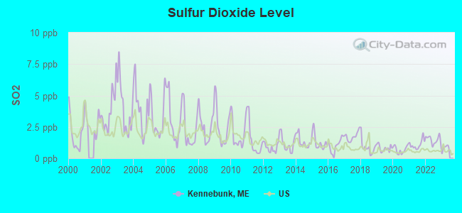
Sulfur Dioxide (SO2) [ppb] level in 2022 was 1.48. This is about average.Closest monitor was 8.4 miles away from the city center.
City:
1.48
U.S.:
1.51
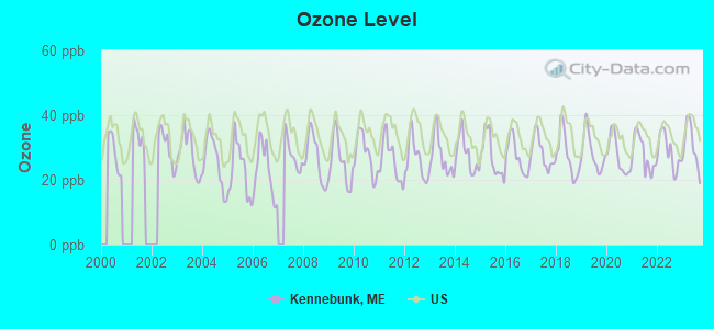
Ozone [ppb] level in 2023 was 30.6. This is about average.Closest monitor was 6.1 miles away from the city center.
City:
30.6
U.S.:
33.3
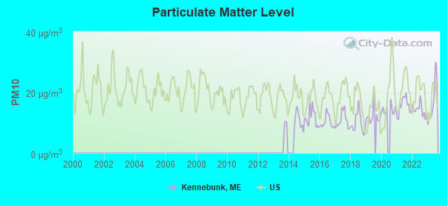
Particulate Matter (PM10) [µg/m3] level in 2023 was 16.9. This is about average.Closest monitor was 8.3 miles away from the city center.
City:
16.9
U.S.:
19.2
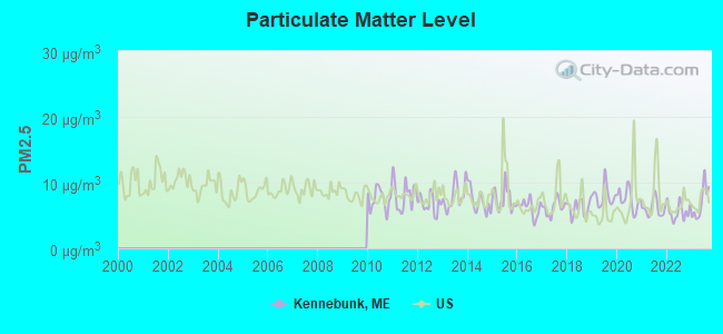
Particulate Matter (PM2.5) [µg/m3] level in 2023 was 6.96. This is about average.Closest monitor was 9.0 miles away from the city center.
City:
6.96
U.S.:
8.11
Tornado activity:
Kennebunk-area historical tornado activity is significantly above Maine state average. It is 70% smaller than the overall U.S. average.
On 6/9/1953, a category F3 (max. wind speeds 158-206 mph) tornado 36.0 miles away from the Kennebunk place center injured 5 peopleand causedbetween $5000 and $50,000 in damages.
On 10/10/1966, a category F2 (max. wind speeds 113-157 mph) tornado 12.4 miles away from the place center causedbetween $5000 and $50,000 in damages.
Earthquake activity:
Kennebunk-area historical earthquake activity is significantly above Maine state average. It is 74% smaller than the overall U.S. average.
On 10/16/2012 at 23:12:25, a magnitude 4.7 (4.7 ML, Depth: 10.0 mi, Class: Light, Intensity: IV - V) earthquake occurred 15.7 miles away from Kennebunk center On 4/20/2002 at 10:50:47, a magnitude 5.3 (5.3 ML, Depth: 3.0 mi, Class: Moderate, Intensity: VI - VII) earthquake occurred 175.4 miles away from the city center On 1/19/1982 at 00:14:42, a magnitude 4.7 (4.5 MB, 4.7 MD, 4.5 LG) earthquake occurred 53.8 miles away from the city center On 10/7/1983 at 10:18:46, a magnitude 5.3 (5.1 MB, 5.3 LG, 5.1 ML) earthquake occurred 194.2 miles away from the city center On 4/20/2002 at 10:50:47, a magnitude 5.2 (5.2 MB, 4.2 MS, 5.2 MW, 5.0 MW) earthquake occurred 175.6 miles away from Kennebunk center On 8/21/1996 at 07:54:14, a magnitude 3.8 (3.8 LG, 3.6 LG, Depth: 6.2 mi, Class: Light, Intensity: II - III) earthquake occurred 68.4 miles away from Kennebunk center Magnitude types: regional Lg-wave magnitude (LG), body-wave magnitude (MB), duration magnitude (MD), local magnitude (ML), surface-wave magnitude (MS), moment magnitude (MW)
Natural disasters:
The number of natural disasters in York County (31) is a lot greater than the US average (15). Major Disasters (Presidential) Declared: 23 Emergencies Declared: 8
Causes of natural disasters: Floods: 21, Storms: 16, Winter Storms: 6, Snows: 5, Winds: 3, Heavy Rains: 2, Hurricanes: 2, Blizzard: 1, Ice Storm: 1, Mudslide: 1, Snowfall: 1, Snowstorm: 1, Tornado: 1, Tropical Storm: 1 (Note: some incidents may be assigned to more than one category).
Hospitals and medical centers in Kennebunk:
S M M C VISITING NURSES (P.O. BOX 739, 72 MAIN STREET)
KINDRED TRANSITIONAL CARE AND REHAB-KENNEBUNK (158 ROSS RD)
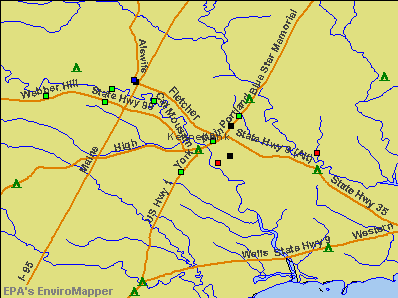
Notable locations in Kennebunk: Kennebunk Recycling Center (A), Kennebunk Town Hall (B), Kennebunk Free Library (C), Brick Store Museum (D), Edith Cleaves Barry Library (E), Kennebunk Fire and Rescue Central Station (F), Wedding Cake House (G), Taylor-Barry House (H), Storer Mansion (I). Display/hide their locations on the map
Churches in Kennebunk include: First Church of Christ Scientist (A), Saint Andrews Presbyterian Church (B), Saint Monicas Catholic Church (C), Bibber Memorial Chapel (D), Christ Church (E), Holy Cross Lutheran Church (F), Kennebunk Baptist Church (G), First Parish Unitarian Church (H). Display/hide their locations on the map
Parks in Kennebunk include: Kennebunk Historic District (1), Rotary Park (2), Rogers Park (3), Parsons Field (4), Lafayette Park (5). Display/hide their locations on the map
Tourist attractions: Travel- Co Of Maine- The (Tours & Charters; 9 Blue Wave Professional Center), Kennebunk Gallery Cottages (Tours & Charters; 65 York STREET(RT1 SOUTH)), Stone Coast Anglers Inc (Tours & Charters; 3 Maria Lane).
Hotels: Econo Lodge (55 York Street), Nuble Light Software (128 Western Avenue), Kennebunk Inn (45 Main Street), Kennebunker Cottages (195 Sea Road), Turnpike Motel (Exit # 3), Lodge at Kennebunk (95 Alewive Road), Host Marriott Corporation (Maine Turnpike South).
Birthplace of: Clement Storer - Politician.
York County has a predicted average indoor radon screening level greater than 4 pCi/L (pico curies per liter) - Highest Potential
Drinking water stations with addresses in Kennebunk and their reported violations in the past:
YANKEELAND CAMPGROUND (Address: 1 Robinson Way , Population served: 525, Groundwater):
Past monitoring violations:
2 routine major monitoring violations
MOUSAM RIVER CAMPGROUND (Population served: 433, Groundwater):
Past monitoring violations:
2 regular monitoring violations
HIDDEN POND II (Population served: 308, Groundwater):
Past monitoring violations:
3 routine major monitoring violations
MILDRED L DAY SCHOOL - ARUNDEL (Population served: 300, Groundwater):
Past health violations:
MCL, Average - Between JUL-01-2008 and OCT-01-2008, Contaminant: Arsenic. Follow-up actions: St Public Notif requested (OCT-28-2008), St Formal NOV issued (OCT-28-2008), St Compliance achieved (APR-21-2009), St Intentional no-action (SEP-15-2011)
MCL, Average - Between APR-2008 and JUN-2008, Contaminant: Arsenic. Follow-up actions: St Public Notif requested (JUL-31-2008), St Formal NOV issued (JUL-31-2008), St Compliance achieved (APR-21-2009), St Intentional no-action (SEP-15-2011)
MCL, Average - Between JAN-2008 and MAR-2008, Contaminant: Arsenic. Follow-up actions: St Public Notif requested (APR-30-2008), St Formal NOV issued (APR-30-2008), St Public Notif received (MAY-08-2008), St Compliance achieved (APR-21-2009)
MCL, Average - Between OCT-2007 and DEC-2007, Contaminant: Arsenic. Follow-up actions: St Public Notif requested (JAN-14-2008), St Formal NOV issued (JAN-14-2008), St Public Notif received (2 times from JAN-24-2008 to JAN-24-2008), St Compliance achieved (APR-21-2009)
MCL, Average - Between JUL-2007 and SEP-2007, Contaminant: Arsenic. Follow-up actions: St Public Notif requested (AUG-30-2007), St Formal NOV issued (AUG-30-2007), St Public Notif received (2 times from SEP-24-2007 to SEP-24-2007), St Compliance achieved (APR-21-2009)
Past monitoring violations:
Follow-up Or Routine LCR Tap M/R - In JAN-01-2007, Contaminant: Lead and Copper Rule. Follow-up actions: St Violation/Reminder Notice (NOV-16-2006), St Public Notif requested (NOV-16-2006), St Public Notif received (NOV-30-2006), St Compliance achieved (OCT-22-2008)
YANKEELAND CAMPGROUND (Address: 1 Robinson Way , Population served: 250, Groundwater):
Past monitoring violations:
One routine major monitoring violation
COCOONS DAY SCHOOL (Population served: 54, Groundwater):
Past health violations:
MCL, Monthly (TCR) - In JAN-2006, Contaminant: Coliform. Follow-up actions: St Violation/Reminder Notice (JAN-27-2006), St Public Notif requested (JAN-27-2006), St Public Notif received (FEB-07-2006), St Compliance achieved (OCT-12-2007)
Past monitoring violations:
2 routine major monitoring violations
HARBORVIEW I & II (Population served: 51, Groundwater):
Past health violations:
Public Education - In JAN-01-2008, Contaminant: Lead and Copper Rule. Follow-up actions: St Formal NOV issued (MAY-14-2008), St Compliance achieved (AUG-04-2008)
MCL, Average - Between APR-2007 and JUN-2007, Contaminant: Arsenic. Follow-up actions: St Public Notif requested (JUL-25-2007), St Violation/Reminder Notice (JUL-25-2007), St Compliance achieved (JUL-23-2008), St Public Notif received (AUG-06-2008)
MCL, Average - Between OCT-2006 and DEC-2006, Contaminant: Arsenic. Follow-up actions: St Public Notif requested (JAN-22-2007), St Violation/Reminder Notice (JAN-22-2007), St Compliance achieved (JUL-23-2008), St Public Notif received (AUG-06-2008)
MCL, Average - Between JUL-2006 and SEP-2006, Contaminant: Arsenic. Follow-up actions: St Public Notif requested (OCT-27-2006), St Violation/Reminder Notice (OCT-27-2006), St Public Notif received (NOV-08-2006), St Compliance achieved (JUL-23-2008)
MCL, Average - Between APR-2006 and JUN-2006, Contaminant: Arsenic. Follow-up actions: St Public Notif requested (JUN-29-2006), St Violation/Reminder Notice (JUN-29-2006), St Public Notif received (2 times from JUL-18-2006 to JUL-18-2006), St Compliance achieved (JUL-23-2008)
MCL, Average - Between JAN-2006 and MAR-2006, Contaminant: Arsenic. Follow-up actions: St Public Notif requested (MAR-29-2006), St Violation/Reminder Notice (MAR-29-2006), St Public Notif received (2 times from JUN-29-2006 to JUN-29-2006), St Compliance achieved (JUL-23-2008)
WEBHANNET GOLF CLUB (Population served: 25, Groundwater):
Past monitoring violations:
3 routine major monitoring violations
49 regular monitoring violations
Drinking water stations with addresses in Kennebunk that have no violations reported:
Likely homosexual households (counted as self-reported same-sex unmarried-partner households)
Lesbian couples: 0.8% of all households
Gay men: 0.5% of all households
109 people in nursing facilities/skilled-nursing facilities in 2010
18 people in group homes intended for adults in 2010
People in group quarters in Kennebunk in 2000:
105 people in nursing homes
12 people in homes for the mentally retarded
3 people in homes for abused, dependent, and neglected children
Banks with branches in Kennebunk (2011 data):
Kennebunk Savings Bank: at 104 Main Street, Kennebunk Financial Center, Lower Village Branch. Info updated 2010/05/27: Bank assets: $821.4 mil, Deposits: $660.6 mil, local headquarters, positive income, Commercial Lending Specialization, 15 total offices
The Camden National Bank: Kennebunk - Hannaford Branch at 65 Portland Rd, branch established on 2010/09/27; Kennebunk Office Branch at 108 Lafayette Center, branch established on 2002/12/30. Info updated 2008/02/27: Bank assets: $2,266.8 mil, Deposits: $1,604.6 mil, headquarters in Camden, ME, positive income, Commercial Lending Specialization, 39 total offices, Holding Company: Camden National Corporation
KeyBank National Association: Kennebunk Branch at 1 Post Office Square, branch established on 1969/12/17. Info updated 2008/03/03: Bank assets: $86,198.8 mil, Deposits: $64,214.8 mil, headquarters in Cleveland, OH, positive income, Commercial Lending Specialization, 1067 total offices, Holding Company: Keycorp
The Bank of Maine: Rivergreen Branch at 36 Portland Road, branch established on 2003/03/13. Info updated 2011/10/17: Bank assets: $783.5 mil, Deposits: $655.7 mil, headquarters in Portland, ME, negative income in the last year, Commercial Lending Specialization, 33 total offices
TD Bank, National Association: Portland Road Branch at 56 Portland Road, branch established on 1987/10/19. Info updated 2010/10/04: Bank assets: $188,912.6 mil, Deposits: $153,149.8 mil, headquarters in Wilmington, DE, positive income, 1314 total offices, Holding Company: Toronto-Dominion Bank, The
People's United Bank: Kennebunk Main Branch at 100 Main St., branch established on 2004/10/12. Info updated 2012/02/16: Bank assets: $27,319.3 mil, Deposits: $20,835.4 mil, headquarters in Bridgeport, CT, positive income, Commercial Lending Specialization, 374 total offices
Biddeford Savings Bank: Kennebunk Branch at 65 Portland Road, branch established on 2011/04/28. Info updated 2006/11/03: Bank assets: $331.7 mil, Deposits: $234.8 mil, headquarters in Biddeford, ME, positive income, Commercial Lending Specialization, 6 total offices
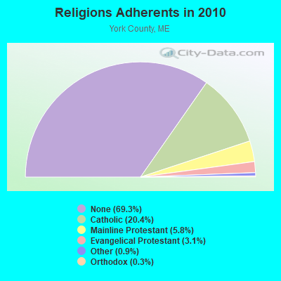
Religion statistics for Kennebunk, ME (based on York County data)
Religion
Adherents
Congregations
Catholic
40,283
16
Mainline Protestant
11,480
64
Evangelical Protestant
6,086
51
Other
1,847
18
Orthodox
625
3
Black Protestant
119
1
None
136,691
-
Source: Clifford Grammich, Kirk Hadaway, Richard Houseal, Dale E.Jones, Alexei Krindatch, Richie Stanley and Richard H.Taylor. 2012. 2010 U.S.Religion Census: Religious Congregations & Membership Study. Association of Statisticians of American Religious Bodies. Jones, Dale E., et al. 2002. Congregations and Membership in the United States 2000. Nashville, TN: Glenmary Research Center. Graphs represent county-level data
169 PORT ROAD, 169 Port Rd. (Lat: 43.360278 Lon: -70.485611), Type: Tower, Structure height: 38.1 m, Call Sign: WME870, Assigned Frequencies: 950.500 MHz, Grant Date: 02/20/1992, Expiration Date: 04/01/2030, Registrant: Fletcher, Heald & Hildreth, P.L.C., 1300 N. 17th St., 11th Floor, Arlington, VA 20009-3801, Phone: (703) 812-0404, Fax: (703) 812-0486, Email:
169 PORT RD, 169 Port Rd (Lat: 43.360278 Lon: -70.485611), Type: Tower, Structure height: 38.1 m, Call Sign: WPOP476, Assigned Frequencies: 951.500 MHz, Grant Date: 07/29/1998, Expiration Date: 04/01/2030, Registrant: Fletcher, Heald & Hildreth, P.L.C., 1300 N. 17th St., 11th Floor, Arlington, VA 20009-3801, Phone: (703) 812-0404, Fax: (703) 812-0486, Email:
TOWN HALL, 1 Summer St (Lat: 43.387528 Lon: -70.536389), Type: Bant, Structure height: 40 m, Overall height: 42 m, Call Sign: WQOK203, Assigned Frequencies: 21925.0 MHz, Grant Date: 10/14/2021, Expiration Date: 10/24/2031, Certifier: Barry Tibbetts, Registrant: Town Of Kennebunk, 1 Summer St, Kennebunk, ME 04043, Phone: (207) 604-1364, Email:
WATER TANK 1, 29 York Street (Lat: 43.381944 Lon: -70.548194), Type: Tank, Structure height: 35 m, Overall height: 41 m, Call Sign: WQOK204, Assigned Frequencies: 17765.0 MHz, 23125.0 MHz, Grant Date: 10/14/2021, Expiration Date: 10/24/2031, Certifier: Barry Tibbetts, Registrant: Town Of Kennebunk, 1 Summer St, Kennebunk, ME 04043, Phone: (207) 604-1364, Email:
FCC Registered Paging Towers:
1
35 Beach Street (Lat: 43.356194 Lon: -70.484750), Call Sign: KNKO383, Assigned Frequencies: 931.887 MHz, Grant Date: 05/11/1999, Expiration Date: 04/01/2009, Cancellation Date: 01/13/2005, Certifier: Paul H Kuzia, Registrant: Venable, LLP, 575 7th Street, Nw, Washington, DC 20004, Phone: (202) 344-4000, Fax: (202) 344-8300, Email:
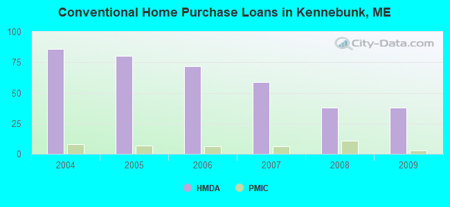
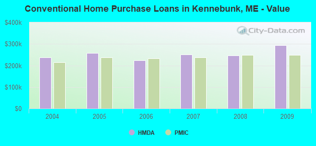
Detailed PMIC statistics for the following Tracts:0280.02
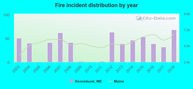
2003 - 2018 National Fire Incident Reporting System (NFIRS) incidents
According to the data from the years 2003 - 2018 the average number of fires per year is 36. The highest number of reported fires - 68 took place in 2018, and the least - 0 in 2010. The data has a rising trend.
When looking into fire subcategories, the most reports belonged to: Structure Fires (49.1%), and Outside Fires (29.0%).
Fire incident types reported to NFIRS in Kennebunk, ME


 Recent articles from our blog. Our writers, many of them Ph.D. graduates or candidates, create easy-to-read articles on a wide variety of topics.

 (23.6 miles
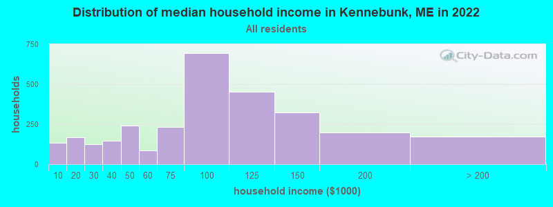


 According to the data from the years 2003 - 2018 the average number of fires per year is 36. The highest number of reported fires - 68 took place in 2018, and the least - 0 in 2010. The data has a rising trend.
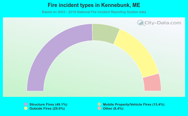 When looking into fire subcategories, the most reports belonged to: Structure Fires (49.1%), and Outside Fires (29.0%).