Osborn, Wisconsin
Submit your own pictures of this town and show them to the world
- OSM Map
- Google Map
- MSN Map
Population change since 2000: +13.7%
 |
| Males: 591 | |
| Females: 579 |
| Median resident age: | 40.4 years |
| Wisconsin median age: | 42.6 years |
Zip codes: 54165.
| Osborn: | $101,512 |
| WI: | $70,996 |
Estimated per capita income in 2022: $41,345 (it was $22,095 in 2000)
Osborn town income, earnings, and wages data
Estimated median house or condo value in 2022: $360,349 (it was $152,400 in 2000)
| Osborn: | $360,349 |
| WI: | $252,800 |
Mean prices in 2022: all housing units: $270,575; detached houses: $276,608; townhouses or other attached units: $227,820; in 2-unit structures: $178,563; in 3-to-4-unit structures: $167,024; in 5-or-more-unit structures: $163,041; mobile homes: $65,227
Detailed information about poverty and poor residents in Osborn, WI


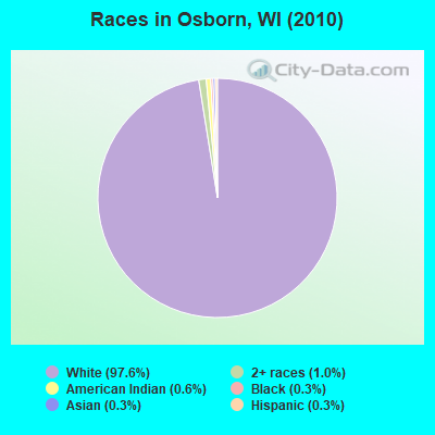
- 1,14297.6%White alone
- 121.0%Two or more races
- 70.6%American Indian alone
- 30.3%Black alone
- 30.3%Asian alone
- 30.3%Hispanic
Races in Osborn detailed stats: ancestries, foreign born residents, place of birth
 Recent articles from our blog. Our writers, many of them Ph.D. graduates or candidates, create easy-to-read articles on a wide variety of topics.
Ancestries: German (58.5%), Dutch (16.0%), Polish (8.9%), United States (7.0%), Irish (6.4%), English (4.2%).
Current Local Time: CST time zone
Land area: 16.9 square miles.
Population density: 69 people per square mile (very low).
3 residents are foreign born
| This town: | 0.3% |
| Wisconsin: | 3.6% |
| Osborn town: | 1.5% ($2,326) |
| Wisconsin: | 2.0% ($2,245) |
Nearest city with pop. 50,000+: Appleton, WI  (13.5 miles , pop. 70,087).
Nearest city with pop. 200,000+: Milwaukee, WI (99.0 miles , pop. 596,974).
Nearest city with pop. 1,000,000+: Chicago, IL (183.9 miles , pop. 2,896,016).
Nearest cities:
), ), ), ), )Latitude: 44.46 N, Longitude: 88.34 W
Area code commonly used in this area: 920
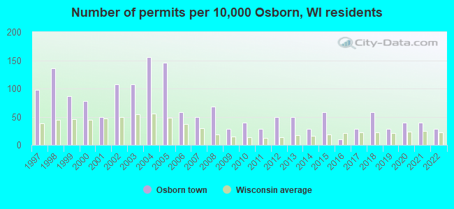
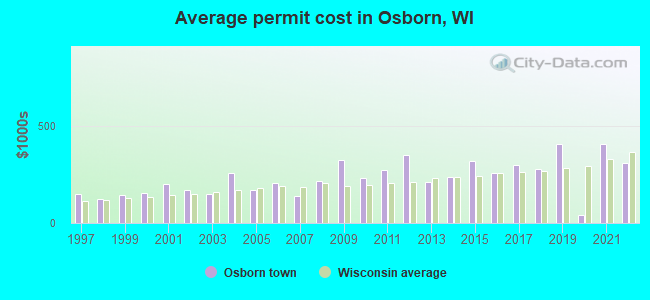
Single-family new house construction building permits:
- 2022: 3 buildings, average cost: $311,700
- 2021: 4 buildings, average cost: $406,300
- 2020: 4 buildings, average cost: $41,900
- 2019: 3 buildings, average cost: $406,700
- 2018: 6 buildings, average cost: $279,500
- 2017: 3 buildings, average cost: $300,000
- 2016: 1 building, cost: $260,000
- 2015: 6 buildings, average cost: $321,500
- 2014: 3 buildings, average cost: $238,300
- 2013: 5 buildings, average cost: $214,400
- 2012: 5 buildings, average cost: $350,100
- 2011: 3 buildings, average cost: $273,300
- 2010: 4 buildings, average cost: $231,300
- 2009: 3 buildings, average cost: $324,600
- 2008: 7 buildings, average cost: $215,600
- 2007: 5 buildings, average cost: $138,200
- 2006: 6 buildings, average cost: $205,200
- 2005: 15 buildings, average cost: $170,000
- 2004: 16 buildings, average cost: $257,600
- 2003: 11 buildings, average cost: $149,200
- 2002: 11 buildings, average cost: $167,900
- 2001: 5 buildings, average cost: $200,800
- 2000: 8 buildings, average cost: $157,400
- 1999: 9 buildings, average cost: $143,300
- 1998: 14 buildings, average cost: $124,200
- 1997: 10 buildings, average cost: $148,200
| Here: | 2.3% |
| Wisconsin: | 2.7% |
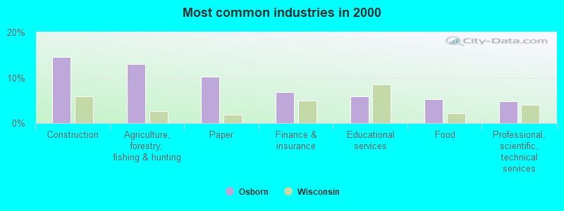
- Construction (14.6%)
- Agriculture, forestry, fishing & hunting (13.0%)
- Paper (10.3%)
- Finance & insurance (6.8%)
- Educational services (5.8%)
- Food (5.3%)
- Professional, scientific, technical services (4.8%)
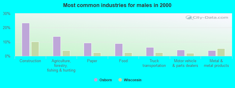
- Construction (23.4%)
- Agriculture, forestry, fishing & hunting (13.9%)
- Paper (9.2%)
- Food (8.9%)
- Truck transportation (6.3%)
- Motor vehicle & parts dealers (4.3%)
- Metal & metal products (4.0%)
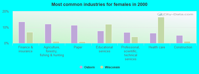
- Finance & insurance (13.5%)
- Agriculture, forestry, fishing & hunting (12.1%)
- Paper (11.4%)
- Educational services (7.8%)
- Professional, scientific, technical services (6.8%)
- Health care (6.4%)
- Construction (5.0%)
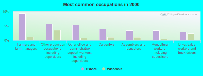
- Farmers and farm managers (9.4%)
- Other production occupations, including supervisors (5.7%)
- Other office and administrative support workers, including supervisors (5.3%)
- Carpenters (4.1%)
- Assemblers and fabricators (3.4%)
- Agricultural workers, including supervisors (3.4%)
- Driver/sales workers and truck drivers (2.9%)
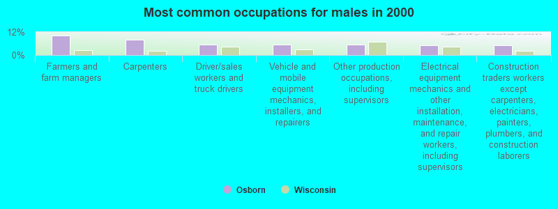
- Farmers and farm managers (10.2%)
- Carpenters (7.9%)
- Driver/sales workers and truck drivers (5.6%)
- Vehicle and mobile equipment mechanics, installers, and repairers (5.3%)
- Other production occupations, including supervisors (5.3%)
- Electrical equipment mechanics and other installation, maintenance, and repair workers, including supervisors (5.0%)
- Construction traders workers except carpenters, electricians, painters, plumbers, and construction laborers (5.0%)
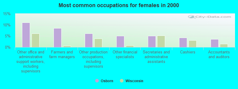
- Other office and administrative support workers, including supervisors (11.0%)
- Farmers and farm managers (8.5%)
- Other production occupations, including supervisors (6.0%)
- Other financial specialists (5.0%)
- Secretaries and administrative assistants (5.0%)
- Cashiers (4.3%)
- Accountants and auditors (3.6%)
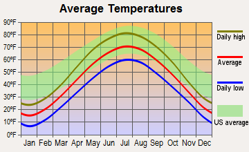
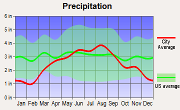
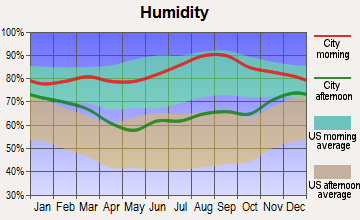
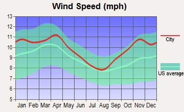
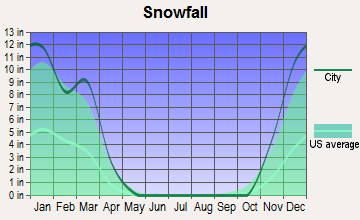
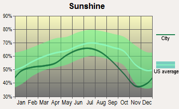
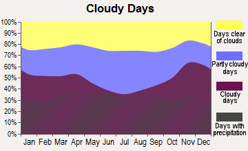
Average climate in Osborn, Wisconsin
Based on data reported by over 4,000 weather stations
(lower is better)
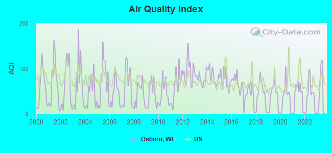
Air Quality Index (AQI) level in 2022 was 37.4. This is significantly better than average.
| City: | 37.4 |
| U.S.: | 72.6 |
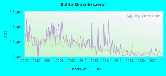
Sulfur Dioxide (SO2) [ppb] level in 2022 was 0.556. This is significantly better than average. Closest monitor was 11.1 miles away from the city center.
| City: | 0.556 |
| U.S.: | 1.515 |
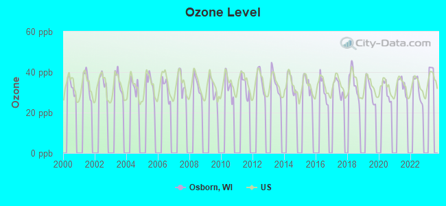
Ozone [ppb] level in 2022 was 31.8. This is about average. Closest monitor was 10.0 miles away from the city center.
| City: | 31.8 |
| U.S.: | 33.3 |
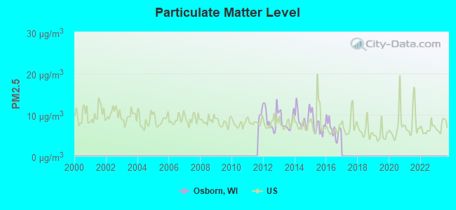
Particulate Matter (PM2.5) [µg/m3] level in 2016 was 6.59. This is better than average. Closest monitor was 17.4 miles away from the city center.
| City: | 6.59 |
| U.S.: | 8.11 |
Tornado activity:
Osborn-area historical tornado activity is near Wisconsin state average. It is 9% greater than the overall U.S. average.
On 4/27/1984, a category F4 (max. wind speeds 207-260 mph) tornado 2.0 miles away from the Osborn town center killed one person and injured 19 people and caused between $500,000 and $5,000,000 in damages.
On 9/26/1951, a category F4 tornado 21.7 miles away from the town center killed 6 people and injured 3 people and caused between $50,000 and $500,000 in damages.
Earthquake activity:
Osborn-area historical earthquake activity is significantly above Wisconsin state average. It is 18% smaller than the overall U.S. average.On 4/18/2008 at 09:36:59, a magnitude 5.4 (5.1 MB, 4.8 MS, 5.4 MW, 5.2 MW, Class: Moderate, Intensity: VI - VII) earthquake occurred 415.9 miles away from Osborn center
On 6/28/2004 at 06:10:52, a magnitude 4.2 (4.2 MW, Depth: 6.2 mi, Class: Light, Intensity: IV - V) earthquake occurred 209.1 miles away from the city center
On 5/2/2015 at 16:23:07, a magnitude 4.2 (4.2 MW, Depth: 2.8 mi) earthquake occurred 212.2 miles away from Osborn center
On 6/10/1987 at 23:48:54, a magnitude 5.1 (4.9 MB, 4.4 MS, 4.6 MS, 5.1 LG) earthquake occurred 390.4 miles away from the city center
On 2/10/2010 at 09:59:35, a magnitude 3.8 (3.8 MW, Depth: 6.2 mi, Class: Light, Intensity: II - III) earthquake occurred 172.2 miles away from Osborn center
On 4/18/2008 at 09:36:59, a magnitude 5.2 (5.2 MW, Depth: 8.9 mi) earthquake occurred 416.0 miles away from Osborn center
Magnitude types: regional Lg-wave magnitude (LG), body-wave magnitude (MB), surface-wave magnitude (MS), moment magnitude (MW)
Natural disasters:
The number of natural disasters in Outagamie County (9) is smaller than the US average (15).Major Disasters (Presidential) Declared: 6
Emergencies Declared: 2
Causes of natural disasters: Floods: 6, Storms: 5, Tornadoes: 3, Drought: 1, Hurricane: 1, Wind: 1, Other: 1 (Note: some incidents may be assigned to more than one category).
Hospitals and medical centers near Osborn:
- GOOD SHEPHERD SERVICES LTD (Nursing Home, about 5 miles away; SEYMOUR, WI)
- FMC - KAUKAUNA (Dialysis Facility, about 12 miles away; KAUKAUNA, WI)
- HEARTLAND HOME HLTH CARE (Home Health Center, about 12 miles away; DE PERE, WI)
- RENNES HEALTH AND REHAB CENTER- APPLETON (Nursing Home, about 12 miles away; APPLETON, WI)
- APPLETON HEALTH CARE CENTER (Nursing Home, about 12 miles away; APPLETON, WI)
- FRANCISCAN CARE CENTER INC (Nursing Home, about 12 miles away; APPLETON, WI)
- ST PAUL HOME (Nursing Home, about 13 miles away; KAUKAUNA, WI)
Colleges/universities with over 2000 students nearest to Osborn:
- Northeast Wisconsin Technical College (about 13 miles; Green Bay, WI; Full-time enrollment: 6,069)
- Fox Valley Technical College (about 14 miles; Appleton, WI; FT enrollment: 5,682)
- Saint Norbert College (about 14 miles; De Pere, WI; FT enrollment: 2,324)
- Lawrence University (about 14 miles; Appleton, WI; FT enrollment: 2,821)
- University of Wisconsin-Green Bay (about 22 miles; Green Bay, WI; FT enrollment: 5,415)
- University of Wisconsin-Oshkosh (about 32 miles; Oshkosh, WI; FT enrollment: 10,637)
- Moraine Park Technical College (about 47 miles; Fond du Lac, WI; FT enrollment: 3,079)
Points of interest:
Notable location: Osborn Fire Department (A). Display/hide its location on the map
Cemetery: Saint John the Baptist Cemetery (1). Display/hide its location on the map
| This town: | 2.9 people |
| Wisconsin: | 2.4 people |
| This town: | 81.9% |
| Whole state: | 64.4% |
| This town: | 5.7% |
| Whole state: | 7.3% |
Likely homosexual households (counted as self-reported same-sex unmarried-partner households)
- Lesbian couples: 0.2% of all households
- Gay men: 0.2% of all households
| This town: | 2.4% |
| Whole state: | 8.7% |
| This town: | 0.2% |
| Whole state: | 3.7% |
For population 15 years and over in Osborn:
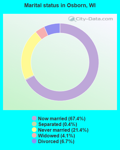
- Never married: 21.4%
- Now married: 67.4%
- Separated: 0.4%
- Widowed: 4.1%
- Divorced: 6.7%
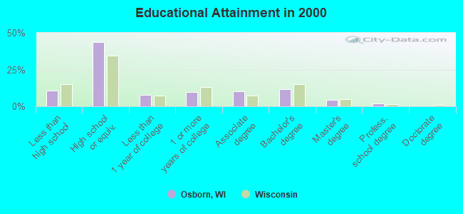
For population 25 years and over in Osborn:
- High school or higher: 89.2%
- Bachelor's degree or higher: 17.7%
- Graduate or professional degree: 6.3%
- Unemployed: 2.5%
- Mean travel time to work (commute): 23.4 minutes
| Here: | 9.0 |
| Wisconsin average: | 11.0 |
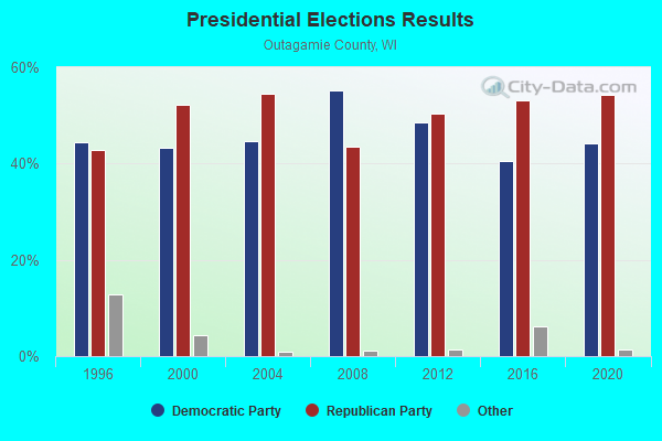
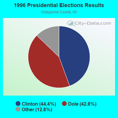
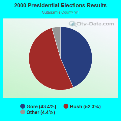
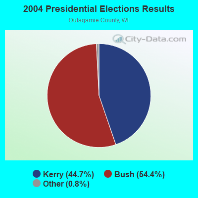
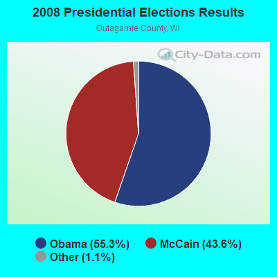
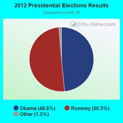
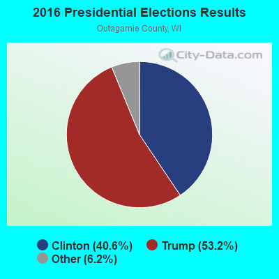
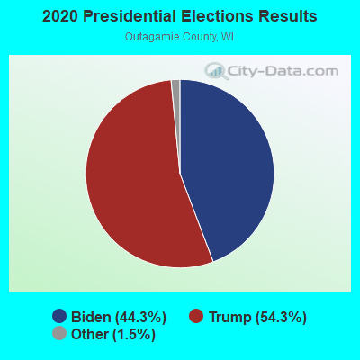
Graphs represent county-level data. Detailed 2008 Election Results
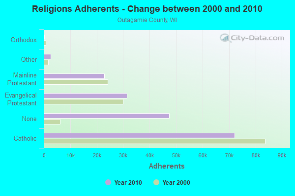
Religion statistics for Osborn, WI (based on Outagamie County data)
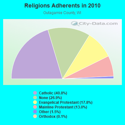
| Religion | Adherents | Congregations |
|---|---|---|
| Catholic | 72,014 | 23 |
| Evangelical Protestant | 31,447 | 72 |
| Mainline Protestant | 22,908 | 29 |
| Other | 2,635 | 13 |
| Orthodox | 224 | 2 |
| None | 47,467 | - |
Food Environment Statistics:
| Outagamie County: | 1.67 / 10,000 pop. |
| Wisconsin: | 1.86 / 10,000 pop. |
| Outagamie County: | 0.12 / 10,000 pop. |
| Wisconsin: | 0.11 / 10,000 pop. |
| Outagamie County: | 0.06 / 10,000 pop. |
| Wisconsin: | 0.38 / 10,000 pop. |
| Outagamie County: | 4.09 / 10,000 pop. |
| Wisconsin: | 4.12 / 10,000 pop. |
| Outagamie County: | 8.58 / 10,000 pop. |
| Wisconsin: | 8.64 / 10,000 pop. |
| Outagamie County: | 7.5% |
| Wisconsin: | 7.6% |
| This county: | 27.1% |
| Wisconsin: | 27.5% |
| This county: | 14.1% |
| Wisconsin: | 13.0% |
Strongest AM radio stations in Osborn:
- WNAM (1280 AM; 50 kW; NEENAH-MENASHA, WI; Owner: CUMULUS LICENSING CORP.)
- WTAQ (1360 AM; 10 kW; GREEN BAY, WI; Owner: MIDWEST COMMUNICATIONS, INC.)
- WHBY (1150 AM; 25 kW; KIMBERLY, WI; Owner: WOODWARD COMMUNICATIONS, INC.)
- WSPT (1010 AM; 50 kW; STEVENS POINT, WI)
- WNFL (1440 AM; 5 kW; GREEN BAY, WI; Owner: MIDWEST COMMUNICATIONS, INC.)
- WSAU (550 AM; 20 kW; WAUSAU, WI; Owner: WRIG, INC.)
- WFCL (1380 AM; 4 kW; CLINTONVILLE, WI; Owner: RESULTS BROADCASTING CORP.)
- WTMJ (620 AM; 50 kW; MILWAUKEE, WI; Owner: JOURNAL BROADCAST CORPORATION)
- WDUX (800 AM; 5 kW; WAUPACA, WI; Owner: LAIRD BROADCASTING COMPANY, INC.)
- WJOK (1050 AM; 1 kW; KAUKAUNA, WI; Owner: STARBOARD BROADCASTING, INC.)
- WTCM (580 AM; 35 kW; TRAVERSE CITY, MI; Owner: WTCM RADIO, INC.)
- WISN (1130 AM; 50 kW; MILWAUKEE, WI; Owner: CAPSTAR TX LIMITED PARTNERSHIP)
- WCUB (980 AM; 5 kW; TWO RIVERS, WI; Owner: CUB RADIO, INC.)
Strongest FM radio stations in Osborn:
- WECB (104.3 FM; SEYMOUR, WI; Owner: WOODWARD COMMUNICATIONS, INC.)
- WAPL-FM (105.7 FM; APPLETON, WI; Owner: WOODWARD COMMUNICATIONS, INC.)
- WIXX (101.1 FM; GREEN BAY, WI; Owner: MIDWEST COMMUNICATIONS, INC.)
- WPNE-FM (89.3 FM; GREEN BAY, WI; Owner: WISCONSIN EDUCATIONAL COMMUNICATIONS BOARD)
- WOGB (103.1 FM; KAUKAUNA, WI; Owner: CUMULUS LICENSING CORP.)
- WHID (88.1 FM; GREEN BAY, WI; Owner: BD OF REGENTS OF THE UNIV OF WI SYS)
- WKSZ (95.9 FM; DE PERE, WI; Owner: WOODWARD COMMUNICATIONS INC)
- WOZZ (93.5 FM; NEW LONDON, WI; Owner: MIDWEST COMMUNICATIONS, INC)
- WXWX (107.5 FM; BRILLION, WI; Owner: CUMULUS LICENSING CORP.)
- WNCY-FM (100.3 FM; NEENAH-MENASHA, WI; Owner: MIDWEST COMMUNICATIONS, INC.)
- WPCK (104.9 FM; KAUKAUNA, WI; Owner: MIDWEST DIMENSIONS, INC.)
- WORQ (90.1 FM; GREEN BAY, WI; Owner: LAKESHORE COMMUNICATIONS, INC.)
- WEMY (91.5 FM; GREEN BAY, WI; Owner: EVANGEL MINISTRIES, INC)
- WQLH (98.5 FM; GREEN BAY, WI; Owner: CUMULUS LICENSING CORP.)
- WLFM (91.1 FM; APPLETON, WI; Owner: LAWRENCE UNIVERSITY OF WISCONSIN)
- W270AJ (101.9 FM; GREEN BAY, WI; Owner: MIDWEST COMMUNICATIONS, INC)
- WJLW (106.7 FM; ALLOUEZ, WI; Owner: CUMULUS LICENSING CORP)
- WEMI (91.9 FM; APPLETON, WI; Owner: EVANGEL MINISTRIES, INC.)
- WRVM (102.7 FM; SURING, WI; Owner: WRVM, INC.)
- WROE (94.3 FM; NEENAH-MENASHA, WI; Owner: MIDWEST COMMUNICATIONS, INC.)
TV broadcast stations around Osborn:
- WBAY-TV (Channel 2; GREEN BAY, WI; Owner: YOUNG BROADCASTING OF GREEN BAY, INC.)
- WLUK-TV (Channel 11; GREEN BAY, WI; Owner: EMMIS TELEVISION LICENSE CORPORATION)
- WFRV-TV (Channel 5; GREEN BAY, WI; Owner: CBS BROADCASTING INC.)
- WPNE (Channel 38; GREEN BAY, WI; Owner: WISCONSIN EDUCATIONAL COMMUNICATIONS BOARD)
- WIWB (Channel 14; SURING, WI; Owner: ACME TV LICENSES OF WISCONSIN, LLC)
- WGBA (Channel 26; GREEN BAY, WI; Owner: ARIES TELECOMMUNICATION CORPORATION)
- WACY (Channel 32; APPLETON, WI; Owner: ACE TV, INC.)
- W49CB (Channel 49; GREEN BAY, WI; Owner: TRINITY BROADCASTING NETWORK)
- WMMF-TV (Channel 68; FOND DU LAC, WI; Owner: PAPPAS TELECASTING OF WISCONSIN, A CALIFORNIA LTD PARTNRSHP)
- W30BU (Channel 30; GREEN BAY, WI; Owner: THREE ANGELS BROADCASTING NETWORK)
- W66DC (Channel 66; WAUPACA, WI; Owner: TRINITY BROADCASTING NETWORK)
- W23BL (Channel 23; TRAVERSE CITY, MI; Owner: MS COMMUNICATIONS, LLC)
- W17CF (Channel 17; RIPON, WI; Owner: TRINITY BROADCASTING NETWORK)
- National Bridge Inventory (NBI) Statistics
- 2Number of bridges
- 7ft / 1.8mTotal length
- $167,000Total costs
- 498Total average daily traffic
- 547Total future (year 2040) average daily traffic
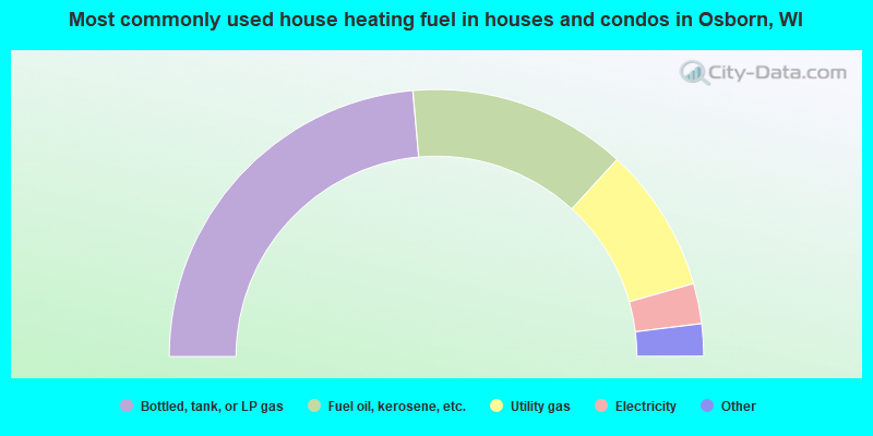
- 47.2%Bottled, tank, or LP gas
- 26.4%Fuel oil, kerosene, etc.
- 17.6%Utility gas
- 4.9%Electricity
- 2.9%Wood
- 1.0%Other fuel
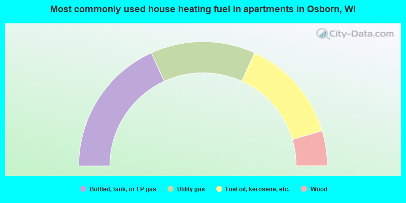
- 36.4%Bottled, tank, or LP gas
- 27.3%Utility gas
- 27.3%Fuel oil, kerosene, etc.
- 9.1%Wood
Osborn compared to Wisconsin state average:
- Unemployed percentage significantly below state average.
- Black race population percentage significantly below state average.
- Hispanic race population percentage significantly below state average.
- Foreign-born population percentage significantly below state average.
- Renting percentage significantly below state average.
- Length of stay since moving in significantly above state average.
- Number of rooms per house significantly below state average.
- House age significantly below state average.
- Number of college students below state average.