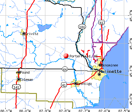
Porterfield, Wisconsin
Submit your own pictures of this town and show them to the world
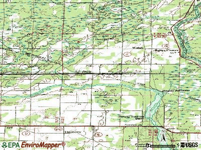
- OSM Map
- General Map
- Google Map
- MSN Map
Population change since 2000: -1.0%
 |
| Males: 1,017 | |
| Females: 954 |
| Median resident age: | 46.3 years |
| Wisconsin median age: | 42.6 years |
Zip codes: 54143.
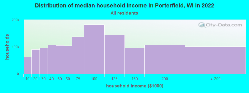
| Porterfield: | $78,655 |
| WI: | $70,996 |
Estimated per capita income in 2022: $36,981 (it was $19,025 in 2000)
Porterfield town income, earnings, and wages data
Estimated median house or condo value in 2022: $208,906 (it was $94,200 in 2000)
| Porterfield: | $208,906 |
| WI: | $252,800 |
Detailed information about poverty and poor residents in Porterfield, WI


- 1,91897.3%White alone
- 211.1%Two or more races
- 140.7%Hispanic
- 90.5%American Indian alone
- 50.3%Black alone
- 30.2%Other race alone
- 10.05%Asian alone
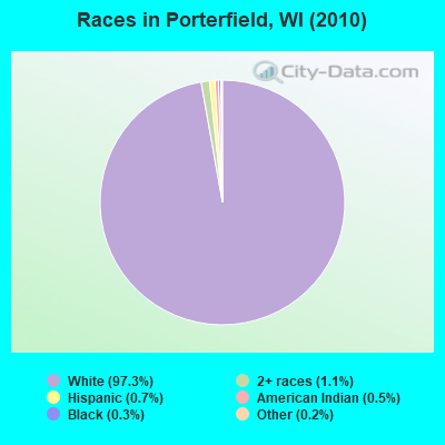
Races in Porterfield detailed stats: ancestries, foreign born residents, place of birth
According to our research of Wisconsin and other state lists, there were 5 registered sex offenders living in Porterfield, Wisconsin as of April 26, 2024.
The ratio of all residents to sex offenders in Porterfield is 394 to 1.
The ratio of registered sex offenders to all residents in this city is near the state average.
 Recent articles from our blog. Our writers, many of them Ph.D. graduates or candidates, create easy-to-read articles on a wide variety of topics.

Latest news from Porterfield, WI collected exclusively by city-data.com from local newspapers, TV, and radio stations
Ancestries: German (47.0%), French (11.6%), Polish (11.3%), Swedish (8.3%), Irish (8.2%), French Canadian (7.4%).
Current Local Time: CST time zone
Elevation: 670 feet
Land area: 51.8 square miles.
Population density: 38 people per square mile (very low).
20 residents are foreign born
| This town: | 1.0% |
| Wisconsin: | 3.6% |
| Porterfield town: | 1.2% ($1,173) |
| Wisconsin: | 2.0% ($2,245) |
Nearest city with pop. 50,000+: Green Bay, WI  (47.1 miles , pop. 102,313).
Nearest city with pop. 200,000+: Milwaukee, WI (146.6 miles , pop. 596,974).
Nearest city with pop. 1,000,000+: Chicago, IL (230.1 miles , pop. 2,896,016).
Nearest cities:
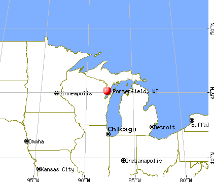
), ), ), Latitude: 45.17 N, Longitude: 87.74 W

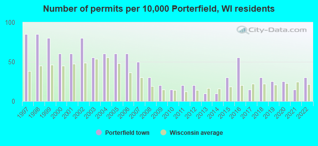
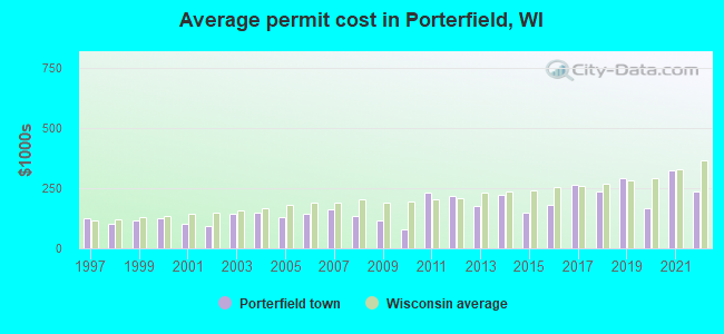
Single-family new house construction building permits:
- 2022: 6 buildings, average cost: $238,300
- 2021: 3 buildings, average cost: $325,000
- 2020: 5 buildings, average cost: $165,700
- 2019: 5 buildings, average cost: $293,600
- 2018: 6 buildings, average cost: $236,100
- 2017: 3 buildings, average cost: $263,600
- 2016: 11 buildings, average cost: $181,000
- 2015: 6 buildings, average cost: $150,000
- 2014: 2 buildings, average cost: $225,000
- 2013: 2 buildings, average cost: $173,900
- 2012: 4 buildings, average cost: $218,800
- 2011: 4 buildings, average cost: $232,500
- 2010: 3 buildings, average cost: $77,800
- 2009: 4 buildings, average cost: $117,800
- 2008: 6 buildings, average cost: $132,500
- 2007: 10 buildings, average cost: $163,400
- 2006: 12 buildings, average cost: $145,300
- 2005: 12 buildings, average cost: $131,800
- 2004: 12 buildings, average cost: $146,800
- 2003: 11 buildings, average cost: $143,400
- 2002: 16 buildings, average cost: $93,400
- 2001: 12 buildings, average cost: $99,600
- 2000: 12 buildings, average cost: $126,900
- 1999: 16 buildings, average cost: $116,400
- 1998: 17 buildings, average cost: $101,300
- 1997: 17 buildings, average cost: $122,500
| Here: | 4.0% |
| Wisconsin: | 2.7% |
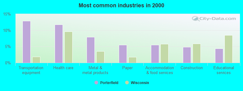
- Transportation equipment (12.8%)
- Health care (11.7%)
- Metal & metal products (7.9%)
- Paper (5.5%)
- Accommodation & food services (5.5%)
- Construction (4.9%)
- Educational services (4.3%)
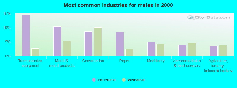
- Transportation equipment (14.6%)
- Metal & metal products (10.5%)
- Construction (8.7%)
- Paper (8.5%)
- Machinery (4.9%)
- Accommodation & food services (3.9%)
- Agriculture, forestry, fishing & hunting (3.6%)
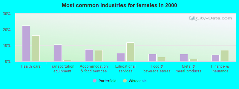
- Health care (22.6%)
- Transportation equipment (10.5%)
- Accommodation & food services (7.6%)
- Educational services (5.3%)
- Food & beverage stores (4.6%)
- Metal & metal products (4.6%)
- Finance & insurance (4.2%)
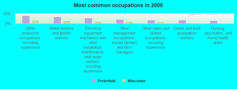
- Other production occupations, including supervisors (8.3%)
- Metal workers and plastic workers (7.0%)
- Electrical equipment mechanics and other installation, maintenance, and repair workers, including supervisors (5.7%)
- Other management occupations, except farmers and farm managers (4.3%)
- Other sales and related occupations, including supervisors (3.8%)
- Cooks and food preparation workers (3.6%)
- Nursing, psychiatric, and home health aides (3.0%)
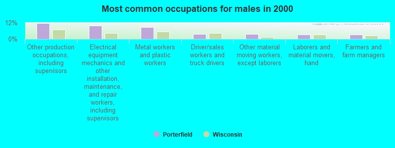
- Other production occupations, including supervisors (11.8%)
- Electrical equipment mechanics and other installation, maintenance, and repair workers, including supervisors (9.8%)
- Metal workers and plastic workers (8.9%)
- Driver/sales workers and truck drivers (3.8%)
- Other material moving workers, except laborers (3.6%)
- Laborers and material movers, hand (3.3%)
- Farmers and farm managers (3.1%)
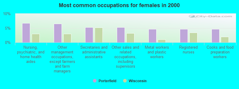
- Nursing, psychiatric, and home health aides (6.8%)
- Other management occupations, except farmers and farm managers (6.5%)
- Secretaries and administrative assistants (5.3%)
- Other sales and related occupations, including supervisors (5.3%)
- Metal workers and plastic workers (4.6%)
- Registered nurses (4.6%)
- Cooks and food preparation workers (4.6%)
Average climate in Porterfield, Wisconsin
Based on data reported by over 4,000 weather stations


Tornado activity:
Porterfield-area historical tornado activity is significantly below Wisconsin state average. It is 49% smaller than the overall U.S. average.
On 8/19/1968, a category F4 (max. wind speeds 207-260 mph) tornado 8.7 miles away from the Porterfield town center killed 2 people and injured 3 people and caused between $500,000 and $5,000,000 in damages.
On 9/28/1971, a category F3 (max. wind speeds 158-206 mph) tornado 13.7 miles away from the town center caused between $50,000 and $500,000 in damages.
Earthquake activity:
Porterfield-area historical earthquake activity is above Wisconsin state average. It is 84% smaller than the overall U.S. average.On 5/2/2015 at 16:23:07, a magnitude 4.2 (4.2 MW, Depth: 2.8 mi, Class: Light, Intensity: IV - V) earthquake occurred 233.4 miles away from Porterfield center
On 6/28/2004 at 06:10:52, a magnitude 4.2 (4.2 MW, Depth: 6.2 mi) earthquake occurred 262.9 miles away from the city center
On 1/31/1986 at 16:46:43, a magnitude 5.0 (5.0 MB, Class: Moderate, Intensity: VI - VII) earthquake occurred 412.5 miles away from Porterfield center
On 9/25/1998 at 19:52:52, a magnitude 5.2 (4.8 MB, 4.3 MS, 5.2 LG, 4.5 MW, Depth: 3.1 mi) earthquake occurred 448.4 miles away from Porterfield center
On 2/10/2010 at 09:59:35, a magnitude 3.8 (3.8 MW, Depth: 6.2 mi, Class: Light, Intensity: II - III) earthquake occurred 224.4 miles away from the city center
On 7/12/1986 at 08:19:37, a magnitude 4.5 (4.5 MB) earthquake occurred 363.0 miles away from the city center
Magnitude types: regional Lg-wave magnitude (LG), body-wave magnitude (MB), surface-wave magnitude (MS), moment magnitude (MW)
Natural disasters:
The number of natural disasters in Marinette County (6) is a lot smaller than the US average (15).Major Disasters (Presidential) Declared: 3
Emergencies Declared: 2
Causes of natural disasters: Floods: 3, Storms: 3, Drought: 1, Hurricane: 1, Tornado: 1, Wind: 1, Other: 1 (Note: some incidents may be assigned to more than one category).
Hospitals and medical centers near Porterfield:
- WHISPERING OAKS CARE CTR (Nursing Home, about 7 miles away; PESHTIGO, WI)
- RESCARE HOME CARE WISCONSIN, INC (Home Health Center, about 8 miles away; MARINETTE, WI)
- RENNES HEALTH AND REHAB CENTER-EAST (Nursing Home, about 8 miles away; PESHTIGO, WI)
- BAY AREA MEDICAL CENTER MENOMNEE (Hospital, about 8 miles away; MENOMINEE, MI)
- DAVITA - MARINETTE DIALYSIS (Dialysis Facility, about 8 miles away; MARINETTE, WI)
- RENNES HEALTH AND REHAB CENTER-WEST (Nursing Home, about 8 miles away; PESHTIGO, WI)
- NORTHLAND LUTH HHS (Home Health Center, about 9 miles away; MARINETTE, WI)
Colleges/universities with over 2000 students nearest to Porterfield:
- University of Wisconsin-Green Bay (about 45 miles; Green Bay, WI; Full-time enrollment: 5,415)
- Northeast Wisconsin Technical College (about 48 miles; Green Bay, WI; FT enrollment: 6,069)
- Saint Norbert College (about 53 miles; De Pere, WI; FT enrollment: 2,324)
- Lawrence University (about 71 miles; Appleton, WI; FT enrollment: 2,821)
- Fox Valley Technical College (about 71 miles; Appleton, WI; FT enrollment: 5,682)
- University of Wisconsin-Oshkosh (about 89 miles; Oshkosh, WI; FT enrollment: 10,637)
- Lakeland College (about 92 miles; Plymouth, WI; FT enrollment: 2,395)
Points of interest:
Notable locations in Porterfield: Brown Memorial Camp (A), Grover - Porterfield Volunteer Fire Department (B). Display/hide their locations on the map
Churches in Porterfield include: Saint Joseph Church (A), Porterfield Church (B). Display/hide their locations on the map
Cemeteries: Winesville Cemetery (1), Saint Joseph Cemetery (2). Display/hide their locations on the map
Reservoir: Bagley Flowage 1061 (A). Display/hide its location on the map
Creek: Twin Creek (A). Display/hide its location on the map
Park in Porterfield: Ziemann Park (1). Display/hide its location on the map
Drinking water stations with addresses in Porterfield and their reported violations in the past:
LEGENDS ON THE HILL (Population served: 25, Groundwater):Past health violations:LOOPYS BAR & GRILL (Population served: 25, Groundwater):Past monitoring violations:
- MCL, Monthly (TCR) - In AUG-2012, Contaminant: Coliform. Follow-up actions: St Boil Water Order (SEP-04-2012), St Violation/Reminder Notice (SEP-04-2012), St Public Notif requested (SEP-04-2012), St Public Notif received (SEP-06-2012), St Compliance achieved (SEP-13-2012)
- Monitoring, Source Water (GWR) - In AUG-2012, Contaminant: E. COLI. Follow-up actions: St Public Notif requested (SEP-27-2012), St Violation/Reminder Notice (SEP-27-2012), St Compliance achieved (DEC-26-2012)
- One routine major monitoring violation
- One minor monitoring violation
Past monitoring violations:RICKS BAR (Population served: 25, Groundwater):
- 5 routine major monitoring violations
- One minor monitoring violation
- 3 regular monitoring violations
Past health violations:SS JOSEPH & EDWARD PARISH (Population served: 25, Groundwater):Past monitoring violations:
- MCL, Monthly (TCR) - In AUG-2010, Contaminant: Coliform. Follow-up actions: St Public Notif requested (SEP-02-2010), St Boil Water Order (SEP-02-2010), St Violation/Reminder Notice (SEP-02-2010), St Public Notif received (SEP-16-2010), St Compliance achieved (NOV-03-2010)
- One routine major monitoring violation
Past health violations:Past monitoring violations:
- MCL, Monthly (TCR) - In OCT-2010, Contaminant: Coliform. Follow-up actions: St Public Notif requested (NOV-01-2010), St Boil Water Order (NOV-01-2010), St Violation/Reminder Notice (NOV-01-2010), St Public Notif received (NOV-04-2010), St Compliance achieved (NOV-09-2010)
- MCL, Monthly (TCR) - In SEP-2010, Contaminant: Coliform. Follow-up actions: St Boil Water Order (SEP-29-2010), St Violation/Reminder Notice (SEP-29-2010), St Public Notif requested (SEP-29-2010), St Compliance achieved (OCT-05-2010), St Public Notif received (OCT-05-2010)
- One minor monitoring violation
Drinking water stations with addresses in Porterfield that have no violations reported:
- PORTERFIELD LUTHERAN CH (Population served: 25, Primary Water Source Type: Groundwater)
| This town: | 2.4 people |
| Wisconsin: | 2.4 people |
| This town: | 73.2% |
| Whole state: | 64.4% |
| This town: | 7.3% |
| Whole state: | 7.3% |
Likely homosexual households (counted as self-reported same-sex unmarried-partner households)
- Lesbian couples: 0.4% of all households
- Gay men: 0.2% of all households
| This town: | 4.7% |
| Whole state: | 8.7% |
| This town: | 1.8% |
| Whole state: | 3.7% |
For population 15 years and over in Porterfield:
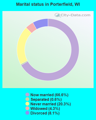
- Never married: 20.3%
- Now married: 66.6%
- Separated: 0.6%
- Widowed: 4.3%
- Divorced: 8.1%
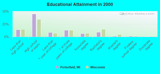
For population 25 years and over in Porterfield:
- High school or higher: 86.0%
- Bachelor's degree or higher: 12.9%
- Graduate or professional degree: 3.6%
- Unemployed: 2.1%
- Mean travel time to work (commute): 24.2 minutes
| Here: | 8.7 |
| Wisconsin average: | 11.0 |
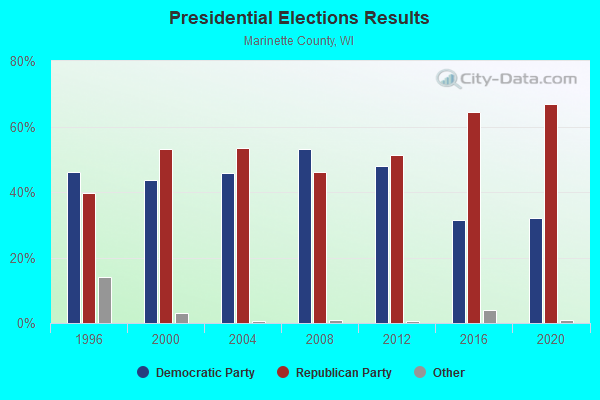
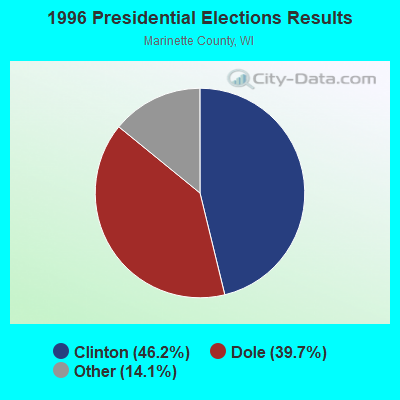
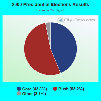
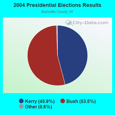
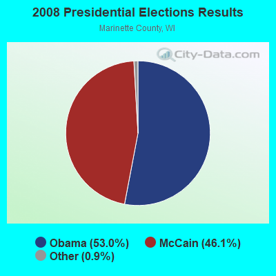
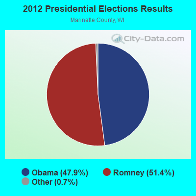
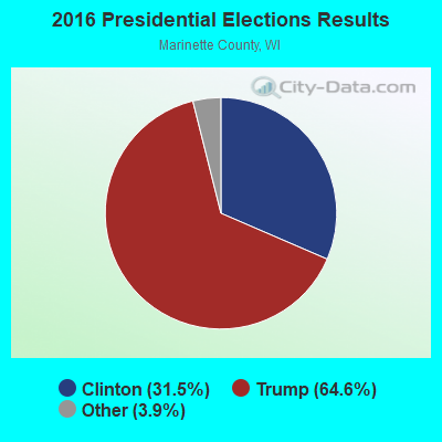
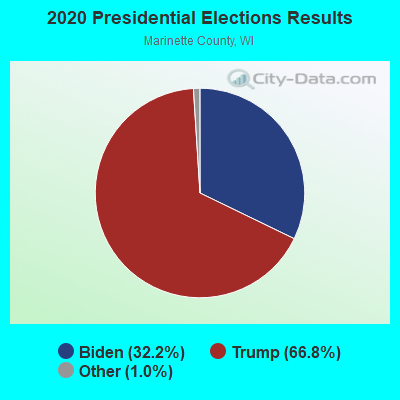
Graphs represent county-level data. Detailed 2008 Election Results
Religion statistics for Porterfield, WI (based on Marinette County data)
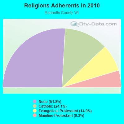
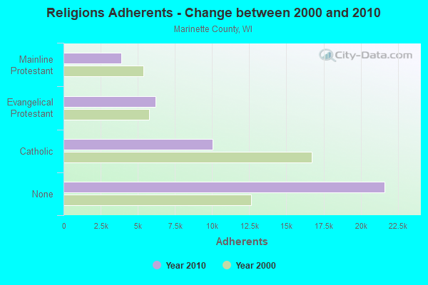
| Religion | Adherents | Congregations |
|---|---|---|
| Catholic | 10,053 | 10 |
| Evangelical Protestant | 6,205 | 33 |
| Mainline Protestant | 3,866 | 20 |
| Other | 1 | 4 |
| None | 21,624 | - |
Food Environment Statistics:
| This county: | 2.83 / 10,000 pop. |
| Wisconsin: | 1.86 / 10,000 pop. |
| Here: | 0.24 / 10,000 pop. |
| Wisconsin: | 0.38 / 10,000 pop. |
| Marinette County: | 7.54 / 10,000 pop. |
| Wisconsin: | 4.12 / 10,000 pop. |
| Marinette County: | 11.78 / 10,000 pop. |
| State: | 8.64 / 10,000 pop. |
| This county: | 7.9% |
| State: | 7.6% |
| Here: | 29.0% |
| State: | 27.5% |
| Marinette County: | 7.1% |
| State: | 13.0% |
Strongest AM radio stations in Porterfield:
- WAGN (1340 AM; 1 kW; MENOMINEE, MI; Owner: BADGER COMMUNICATIONS, L.L.C.)
- WMAM (570 AM; 0 kW; MARINETTE, WI; Owner: BADGER COMMUNICATIONS L.L.C.)
- WNAM (1280 AM; 50 kW; NEENAH-MENASHA, WI; Owner: CUMULUS LICENSING CORP.)
- WDBC (680 AM; 10 kW; ESCANABA, MI; Owner: KMB BROADCASTING, INC.)
- WTCM (580 AM; 35 kW; TRAVERSE CITY, MI; Owner: WTCM RADIO, INC.)
- WSPT (1010 AM; 50 kW; STEVENS POINT, WI)
- WSAU (550 AM; 20 kW; WAUSAU, WI; Owner: WRIG, INC.)
- WHBY (1150 AM; 25 kW; KIMBERLY, WI; Owner: WOODWARD COMMUNICATIONS, INC.)
- WLDR (1210 AM; daytime; 50 kW; KINGSLEY, MI; Owner: FORT BEND BROADCASTING COMPANY)
- WTAQ (1360 AM; 10 kW; GREEN BAY, WI; Owner: MIDWEST COMMUNICATIONS, INC.)
- WTMJ (620 AM; 50 kW; MILWAUKEE, WI; Owner: JOURNAL BROADCAST CORPORATION)
- WOCO (1260 AM; 1 kW; OCONTO, WI; Owner: LAMARDO INC.)
- WEBC (560 AM; 50 kW; DULUTH, MN)
Strongest FM radio stations in Porterfield:
- WSFQ (96.3 FM; PESHTIGO, WI; Owner: BADGER COMMUNICATIONS, L.L.C.)
- WLST (95.1 FM; MARINETTE, WI; Owner: BADGER COMMUNICATIONS L.L.C.)
- WHYB (103.7 FM; MENOMINEE, MI; Owner: BADGER COMMUNICATIONS, L.L.C.)
- WMXG (106.3 FM; STEPHENSON, MI; Owner: ESCANABA LICENSE CORP.)
- WRVM (102.7 FM; SURING, WI; Owner: WRVM, INC.)
- WPFF (90.5 FM; STURGEON BAY, WI; Owner: FAMILY ED BC CORP OF DOOR COUNTY WI)
- WDOR-FM (93.9 FM; STURGEON BAY, WI; Owner: DOOR COUNTY BROADCASTING CO., INC.)
- WLWR-LP (107.7 FM; MARINETTE, WI; Owner: MARINETTE RADIO ASSOCIATION)
- WSRG (97.7 FM; STURGEON BAY, WI; Owner: MAGNUM BROADCASTING, INC.)
- WRGX (88.5 FM; STURGEON BAY, WI; Owner: FAMILY ED B/C CORP OF DOOR COUNTY WI)
- WHDI (91.9 FM; SISTER BAY, WI; Owner: STATE OF WISCONSIN - EDUCATIONAL COMMUNICATIONS BOARD)
- WHND (89.7 FM; SISTER BAY, WI; Owner: STATE OF WISCONSIN - EDUCATIONAL COMMUNICATIONS BOARD)
- W297AE (107.3 FM; STEPHENSON, MI; Owner: BD OF CNTRL, NORTHERN MICHIGAN UNIV)
TV broadcast stations around Porterfield:
- WIWB (Channel 14; SURING, WI; Owner: ACME TV LICENSES OF WISCONSIN, LLC)
- W22BW (Channel 22; STURGEON BAY, WI; Owner: ARIES TELECOMMUNICATION CORPORATION)
- National Bridge Inventory (NBI) Statistics
- 2Number of bridges
- 20ft / 6.4mTotal length
- 2,405Total average daily traffic
- 126Total average daily truck traffic
- 3,365Total future (year 2039) average daily traffic
FCC Registered Antenna Towers:
2- Julie Heffernan, Bagley Road, Type: 96.0, Structure height: 55075 m, Overall height: 93 m, Registrant: Vertical Bridge Reit LLC, Julie.Heffernan@verticalbridge.Com, , Boca -Raton, Phone: (561) 279-6348
- JULIE HEFFERNAN, Bagley Road (Lat: 45.177250 Lon: -87.757333), Type: 96.0, Structure height: 55075 m, Overall height: 93 m, Registrant: Vertical Bridge Reit LLC, Julie.Heffernan@verticalbridge.Com, , Boca -Raton, Phone: (561) 279-6348
FCC Registered Broadcast Land Mobile Towers:
2- Lat: 45.187278 Lon: -87.901917, Call Sign: WQCV429,
Assigned Frequencies: 159.960 MHz, Grant Date: 03/24/2015, Expiration Date: 06/03/2025, Certifier: Harold J Kaufman, Registrant: Baycom Inc, 2040 Raddison Street, Green Bay, WI 54302, Phone: (920) 544-4248, Fax: (920) 468-8615, Email:
- Lat: 45.186806 Lon: -87.920028, Call Sign: WQYH734,
Assigned Frequencies: 457.125 MHz, Grant Date: 10/03/2016, Expiration Date: 10/03/2026, Certifier: Troy Wiedemeier, Registrant: Baycom Inc, 2040 Radisson Street, Green Bay, WI 54302, Phone: (920) 544-4248, Fax: (920) 468-8615, Email:
FCC Registered Amateur Radio Licenses:
14 (See the full list of FCC Registered Amateur Radio Licenses in Porterfield)FAA Registered Aircraft:
1- Aircraft: CESSNA 172F (Category: Land, Seats: 4, Weight: Up to 12,499 Pounds, Speed: 105 mph), Engine: CONT MOTOR 0-300-D (145 HP) (Reciprocating)
N-Number: 5343R, N5343R, N-5343R, Serial Number: 17252871, Year manufactured: 1965, Airworthiness Date: 04/22/1965, Certificate Issue Date: 01/24/2007
Registrant (Individual): Michael E Mcmahon, W3346 Borderline Rd, Porterfield, WI 54159
| Most common first names in Porterfield, WI among deceased individuals | ||
| Name | Count | Lived (average) |
|---|---|---|
| John | 13 | 76.1 years |
| George | 9 | 81.6 years |
| Clarence | 7 | 77.8 years |
| Robert | 7 | 73.1 years |
| Fred | 6 | 81.5 years |
| Raymond | 6 | 75.7 years |
| Edward | 6 | 77.8 years |
| William | 6 | 69.2 years |
| Clara | 5 | 85.6 years |
| Joseph | 5 | 75.6 years |
| Most common last names in Porterfield, WI among deceased individuals | ||
| Last name | Count | Lived (average) |
|---|---|---|
| Johnson | 8 | 71.8 years |
| Vista | 6 | 80.4 years |
| Wickman | 6 | 85.0 years |
| Berg | 5 | 79.4 years |
| Kaufman | 5 | 77.2 years |
| Rastall | 5 | 76.4 years |
| Schultz | 5 | 76.0 years |
| Just | 4 | 74.2 years |
| Guth | 4 | 82.9 years |
| Olson | 4 | 85.3 years |
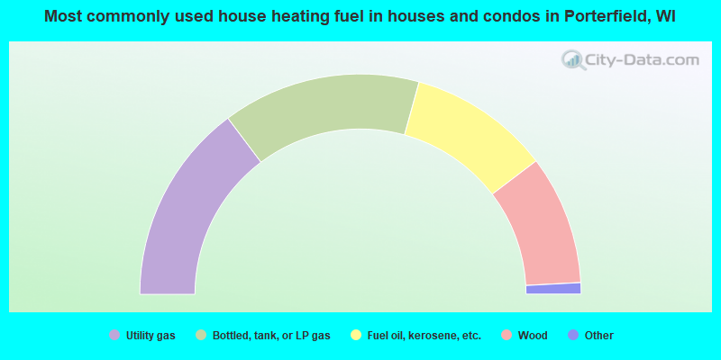
- 29.5%Utility gas
- 29.1%Bottled, tank, or LP gas
- 20.7%Fuel oil, kerosene, etc.
- 19.0%Wood
- 1.4%Electricity
- 0.3%Other fuel
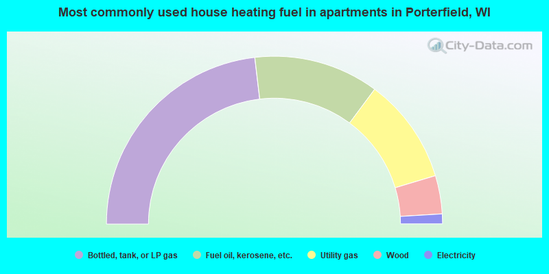
- 46.3%Bottled, tank, or LP gas
- 24.1%Fuel oil, kerosene, etc.
- 20.4%Utility gas
- 7.4%Wood
- 1.9%Electricity
Porterfield compared to Wisconsin state average:
- Unemployed percentage significantly below state average.
- Black race population percentage significantly below state average.
- Hispanic race population percentage significantly below state average.
- Foreign-born population percentage significantly below state average.
- Renting percentage significantly below state average.
- Length of stay since moving in significantly above state average.
- Number of rooms per house significantly below state average.
- House age significantly below state average.
- Number of college students below state average.
- Percentage of population with a bachelor's degree or higher below state average.

|
Total of 5 patent applications in 2008-2024.