Quay, Oklahoma
Submit your own pictures of this town and show them to the world
- OSM Map
- General Map
- Google Map
- MSN Map

| Males: 24 | |
| Females: 29 |
| Median resident age: | 38.5 years |
| Oklahoma median age: | 35.5 years |
Zip code: 74085
| Quay: | |
| OK: |
Estimated per capita income in 2022: $16,448 (it was $9,736 in 2000)
Estimated median house or condo value in 2022: $-753,357,130 (it was $12,500 in 2000)
| Quay: | |
| OK: |
Mean prices in 2022: all housing units: $247,070; detached houses: $264,989; townhouses or other attached units: $231,263; in 2-unit structures: $235,838; in 5-or-more-unit structures: $468,072; mobile homes: $119,820; occupied boats, rvs, vans, etc.: $53,267
Detailed information about poverty and poor residents in Quay, OK


 Recent articles from our blog. Our writers, many of them Ph.D. graduates or candidates, create easy-to-read articles on a wide variety of topics.

 | I'm Choctaw...Now What? (63 replies) |
Latest news from Quay, OK collected exclusively by city-data.com from local newspapers, TV, and radio stations
Ancestries: German (14.9%), United States (14.9%), Irish (8.5%), English (4.3%).
Current Local Time: CST time zone
Elevation: 930 feet
Land area: 0.19 square miles.
Population density: 282 people per square mile (very low).

| Quay town: | 1.6% ($199) |
| Oklahoma: | 0.8% ($523) |
Nearest city with pop. 50,000+: Tulsa, OK  (43.3 miles , pop. 393,049).
Nearest city with pop. 1,000,000+: Dallas, TX (232.5 miles , pop. 1,188,580).
Nearest cities:
), ), )Latitude: 36.16 N, Longitude: 96.71 W
Area code commonly used in this area: 918

| Here: | 2.6% |
| Oklahoma: | 3.2% |
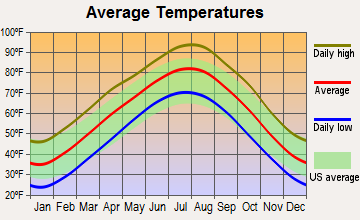
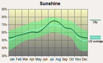
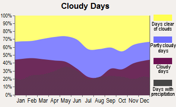
Average climate in Quay, Oklahoma
Based on data reported by over 4,000 weather stations

(lower is better)
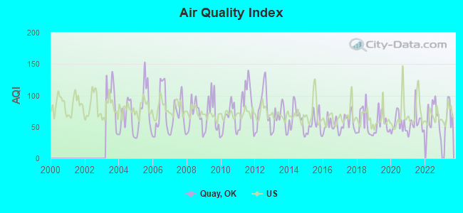
Air Quality Index (AQI) level in 2022 was 65.4. This is about average.
| City: | 65.4 |
| U.S.: | 72.6 |
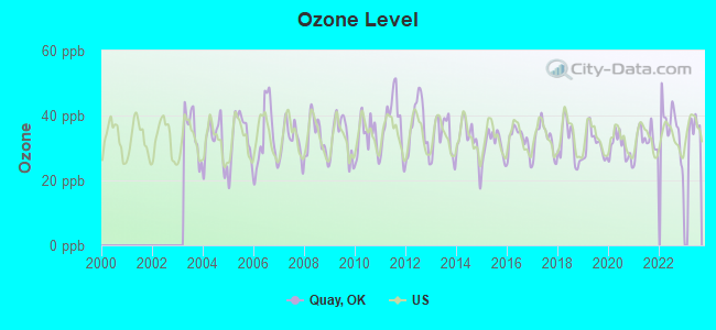
Ozone [ppb] level in 2022 was 36.8. This is about average. Closest monitor was 19.9 miles away from the city center.
| City: | 36.8 |
| U.S.: | 33.3 |
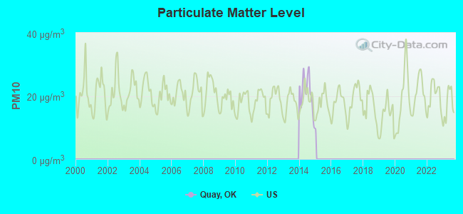
Particulate Matter (PM10) [µg/m3] level in 2014 was 21.0. This is about average. Closest monitor was 24.5 miles away from the city center.
| City: | 21.0 |
| U.S.: | 19.2 |
Tornado activity:
Quay-area historical tornado activity is slightly above Oklahoma state average. It is 199% greater than the overall U.S. average.
On 4/26/1984, a category F4 (max. wind speeds 207-260 mph) tornado 8.3 miles away from the Quay town center killed 3 people and injured 37 people and caused between $500,000 and $5,000,000 in damages.
On 4/26/1991, a category F4 tornado 10.7 miles away from the town center killed one person and injured 24 people and caused between $500,000 and $5,000,000 in damages.
Earthquake activity:
Quay-area historical earthquake activity is significantly above Oklahoma state average. It is 882% greater than the overall U.S. average.On 9/3/2016 at 12:02:44, a magnitude 5.8 (5.8 MW, Depth: 3.5 mi, Class: Moderate, Intensity: VI - VII) earthquake occurred 22.0 miles away from the city center
On 11/6/2011 at 03:53:10, a magnitude 5.7 (5.7 MW, Depth: 3.2 mi) earthquake occurred 43.6 miles away from the city center
On 11/7/2016 at 01:44:24, a magnitude 5.0 (5.0 MW, Depth: 2.8 mi) earthquake occurred 12.8 miles away from Quay center
On 11/5/2011 at 07:12:45, a magnitude 4.8 (4.8 MW, Depth: 1.9 mi, Class: Light, Intensity: IV - V) earthquake occurred 42.3 miles away from Quay center
On 11/8/2011 at 02:46:57, a magnitude 4.8 (4.8 MW, Depth: 3.1 mi) earthquake occurred 43.7 miles away from Quay center
On 2/13/2016 at 17:07:06, a magnitude 5.1 (5.1 MW, Depth: 5.2 mi) earthquake occurred 113.6 miles away from Quay center
Magnitude types: moment magnitude (MW)
Natural disasters:
The number of natural disasters in Payne County (29) is a lot greater than the US average (15).Major Disasters (Presidential) Declared: 19
Emergencies Declared: 6
Causes of natural disasters: Storms: 12, Floods: 11, Winter Storms: 8, Tornadoes: 7, Fires: 5, Ice Storms: 2, Hurricane: 1, Wind: 1, Other: 1 (Note: some incidents may be assigned to more than one category).

Hospitals and medical centers near Quay:
- SOUTHERN OAKS CARE CENTER (Nursing Home, about 13 miles away; PAWNEE, OK)
- REST HAVEN NURSING CENTER (Nursing Home, about 13 miles away; CUSHING, OK)
- HILLCREST HOSPITAL CUSHING Acute Care Hospitals (about 13 miles away; CUSHING, OK)
- DRUMRIGHT NURSING HOME (Nursing Home, about 13 miles away; DRUMRIGHT, OK)
- CARING HANDS HOSPICE (Hospital, about 13 miles away; PAWNEE, OK)
- HILLCREST REGIONAL HOME HEALTH (Home Health Center, about 13 miles away; CUSHING, OK)
- LINWOOD VILLAGE NURSING AND RETIREMENT APTS (Nursing Home, about 13 miles away; CUSHING, OK)
Colleges/universities with over 2000 students nearest to Quay:
- Oklahoma State University-Main Campus (about 21 miles; Stillwater, OK; Full-time enrollment: 21,700)
- Langston University (about 35 miles; Langston, OK; FT enrollment: 2,075)
- University of Tulsa (about 43 miles; Tulsa, OK; FT enrollment: 3,702)
- Oral Roberts University (about 43 miles; Tulsa, OK; FT enrollment: 3,216)
- Tulsa Community College (about 46 miles; Tulsa, OK; FT enrollment: 12,480)
- Northern Oklahoma College (about 49 miles; Tonkawa, OK; FT enrollment: 3,414)
- University of Central Oklahoma (about 55 miles; Edmond, OK; FT enrollment: 13,790)
Points of interest:
| This town: | 3.1 people |
| Oklahoma: | 2.5 people |
| This town: | 100.0% |
| Whole state: | 69.1% |
| This town: | 0.0% |
| Whole state: | 4.0% |
No gay or lesbian households reported
For population 15 years and over in Quay:
- Never married: 0.0%
- Now married: 100.0%
- Separated: 0.0%
- Widowed: 0.0%
- Divorced: 0.0%
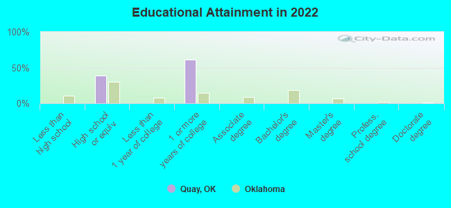
For population 25 years and over in Quay:
- High school or higher: 100.0%
- Bachelor's degree or higher: 0.0%
- Graduate or professional degree: 0.0%
- Unemployed: 11.8%
- Mean travel time to work (commute): 62.0 minutes
| Here: | 3.6 |
| Oklahoma average: | 11.3 |
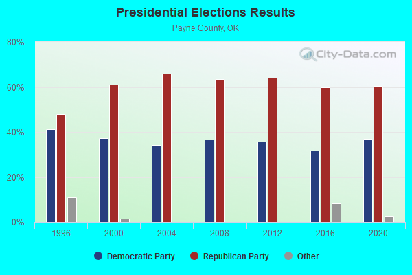
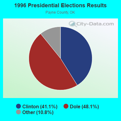
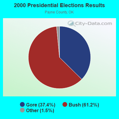
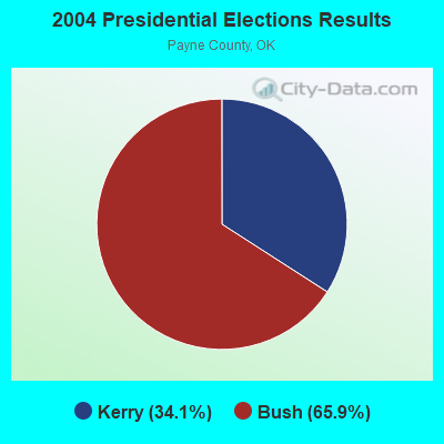

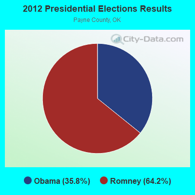
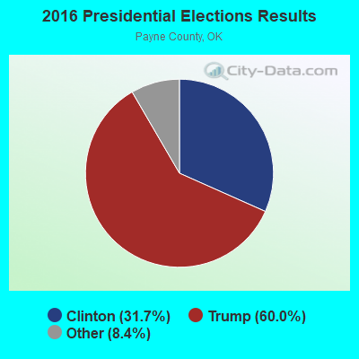

Graphs represent county-level data. Detailed 2008 Election Results
Religion statistics for Quay, OK (based on Payne County data)
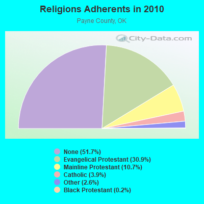
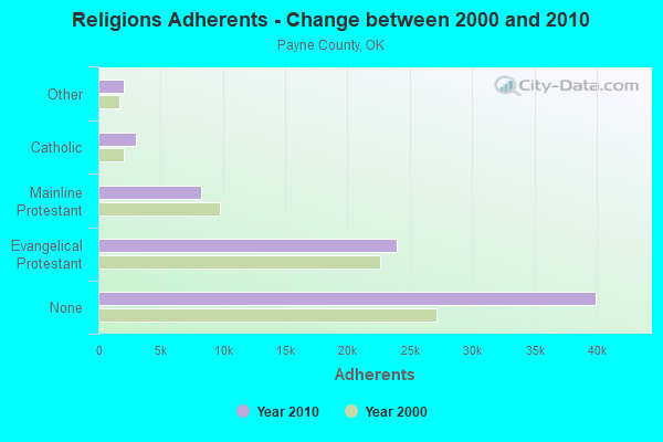
| Religion | Adherents | Congregations |
|---|---|---|
| Evangelical Protestant | 23,907 | 86 |
| Mainline Protestant | 8,260 | 16 |
| Catholic | 3,000 | 3 |
| Other | 2,035 | 13 |
| Black Protestant | 191 | 2 |
| None | 39,957 | - |
Food Environment Statistics:
| This county: | 0.77 / 10,000 pop. |
| Oklahoma: | 1.97 / 10,000 pop. |
| Payne County: | 0.13 / 10,000 pop. |
| Oklahoma: | 0.20 / 10,000 pop. |
| Here: | 4.37 / 10,000 pop. |
| Oklahoma: | 4.35 / 10,000 pop. |
| Here: | 6.18 / 10,000 pop. |
| Oklahoma: | 6.89 / 10,000 pop. |
| This county: | 8.5% |
| Oklahoma: | 10.3% |
| Payne County: | 30.4% |
| Oklahoma: | 29.2% |
Strongest AM radio stations in Quay:
- KRMG (740 AM; 50 kW; TULSA, OK; Owner: CXR HOLDINGS, INC.)
- KFAQ (1170 AM; 50 kW; TULSA, OK; Owner: JOURNAL BROADCAST CORPORATION)
- KTBZ (1430 AM; 25 kW; TULSA, OK; Owner: CLEAR CHANNEL BROADCASTING LICENSES, INC.)
- KMUS (1380 AM; 20 kW; MUSKOGEE, OK; Owner: ABC, INC.)
- KOMA (1520 AM; 50 kW; OKLAHOMA CITY, OK; Owner: RENDA BROADCASTING CORP. OF NEVADA)
- KCFO (970 AM; 2 kW; TULSA, OK; Owner: FRIENDSHIP BROADCASTING, L. P.)
- KAKC (1300 AM; 5 kW; TULSA, OK; Owner: CLEAR CHANNEL BROADCASTING LICENSES, INC.)
- KCRC (1390 AM; 10 kW; ENID, OK; Owner: CHISHOLM TRAIL BROADCASTING CO.)
- KGGF (690 AM; 10 kW; COFFEYVILLE, KS; Owner: KGGF-KUSN, INC.)
- WKY (930 AM; 5 kW; OKLAHOMA CITY, OK; Owner: CITADEL BROADCASTING COMPANY)
- WWLS (640 AM; 5 kW; MOORE, OK; Owner: CITADEL BROADCASTING COMPANY)
- KYAL (1550 AM; 2 kW; SAPULPA, OK; Owner: KXOJ, INC.)
- KTOK (1000 AM; 5 kW; OKLAHOMA CITY, OK; Owner: CLEAR CHANNEL BROADCASTING LICENSES, INC.)
Strongest FM radio stations in Quay:
- KOSU-FM (91.7 FM; STILLWATER, OK; Owner: OKLAHOMA STATE UNIVERSITY)
- KSPI-FM (93.7 FM; STILLWATER, OK; Owner: STILLWATER BROADCASTING, L.L.C.)
- KMOD-FM (97.5 FM; TULSA, OK; Owner: CLEAR CHANNEL BROADCASTING LICENSES, INC.)
- KRAV-FM (96.5 FM; TULSA, OK; Owner: CXR HOLDINGS, INC.)
- KWEN (95.5 FM; TULSA, OK; Owner: CXR HOLDINGS, INC.)
- KBEZ (92.9 FM; TULSA, OK; Owner: RENDA BROADCASTING CORP. OF NEVADA)
- KVOO-FM (98.5 FM; TULSA, OK; Owner: JOURNAL BROADCAST CORPORATION)
- KGFY (105.5 FM; STILLWATER, OK; Owner: STILLWATER BROADCASTING, LLC)
- KXBL (99.5 FM; HENRYETTA, OK; Owner: JOURNAL BROADCAST CORPORATION)
- K202CP (88.3 FM; STILLWATER, OK; Owner: PENSACOLA CHRISTIAN COLLEGE, INC.)
- KTSO (94.1 FM; OKMULGEE, OK; Owner: SHAMROCK COMMUNICATIONS, INC)
- K296EH (107.1 FM; PERRY, OK; Owner: THE LOVE STATION, INC.)
- KVRO (98.1 FM; STILLWATER, OK; Owner: STILLWATER BROADCASTING, LLC)
TV broadcast stations around Quay:
- KWTV (Channel 9; OKLAHOMA CITY, OK; Owner: GRIFFIN ENTITIES, L.L.C.)
- K21DF (Channel 21; STILLWATER, OK; Owner: LOCKE SUPPLY CO.)
- KWEM-LP (Channel 31; STILLWATER, OK; Owner: WESTWOOD MEDIA GROUP, INC.)
- KTPX (Channel 44; OKMULGEE, OK; Owner: PAXSON TULSA LICENSE, INC.)
- KOTV (Channel 6; TULSA, OK; Owner: GRIFFIN LICENSING, L.L.C.)
- KLOT-LP (Channel 25; TULSA, OK; Owner: EQUITY BROADCASTING CORPORATION)
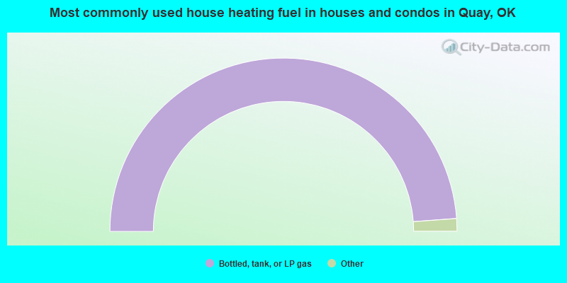
- 100.0%Bottled, tank, or LP gas
Quay compared to Oklahoma state average:
- Median household income significantly below state average.
- Median house value significantly below state average.
- Black race population percentage significantly below state average.
- Hispanic race population percentage significantly below state average.
- Foreign-born population percentage significantly below state average.
- Renting percentage significantly below state average.
- Length of stay since moving in significantly above state average.
- Number of rooms per house significantly below state average.
- House age significantly below state average.
- Number of college students significantly below state average.
- Percentage of population with a bachelor's degree or higher significantly below state average.