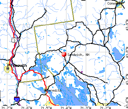
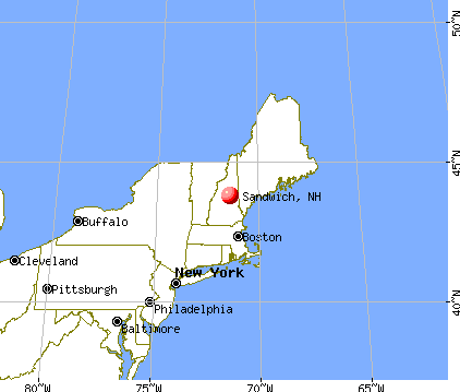
Sandwich, New Hampshire
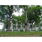
Sandwich: Remnants of the Civil War Era
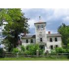
Sandwich: The Haunted House
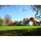
Sandwich: Village of Center Sandwich in autumn
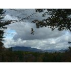
Sandwich: Soft clouds over the mountains

Sandwich: Doug's rainbow.

Sandwich: Pretty cow.
- add
your
Submit your own pictures of this town and show them to the world
- OSM Map
- General Map
- Google Map
- MSN Map
Population change since 2000: +3.1%
 |
| Males: 651 | |
| Females: 675 |
| Median resident age: | 53.2 years |
| New Hampshire median age: | 43.9 years |
Zip codes: 03227.
| Sandwich: | $90,262 |
| NH: | $89,992 |
Estimated per capita income in 2022: $53,231 (it was $23,714 in 2000)
Sandwich town income, earnings, and wages data
Estimated median house or condo value in 2022: $479,095 (it was $156,600 in 2000)
| Sandwich: | $479,095 |
| NH: | $384,700 |
Mean prices in 2022: all housing units: $505,201; detached houses: $542,950; townhouses or other attached units: $363,532; in 2-unit structures: $373,773; in 3-to-4-unit structures: $587,160; in 5-or-more-unit structures: $313,992; mobile homes: $113,714; occupied boats, rvs, vans, etc.: $118,400
Detailed information about poverty and poor residents in Sandwich, NH
Compare current foreclosures near Sandwich, NH:
| Photo | Address | Area | Beds / Baths | Price | Details |
|---|---|---|---|---|---|

|
#1
Summit View Dr
Moultonborough, NH 03254
|
840 sq. feet
|
2 baths 3 beds |
show details | |

|
#2
Governor Wentworth Hwy
Moultonborough, NH 03254
|
1,510 sq. feet
|
1 baths 3 beds |
show details | |

|
#3
Pleasant St
Meredith, NH 03253
|
3,096 sq. feet
|
2 baths 4 beds |
show details | |

|
#4
Plymouth St
Meredith, NH 03253
|
2,232 sq. feet
|
2 baths 4 beds |
show details | |

|
#5
Nh Route 16
Conway, NH 03818
|
2,695 sq. feet
|
2 baths 3 beds |
show details | |

|
#6
Summit Dr
Campton, NH 03223
|
- sq. feet
|
- baths - beds |
show details | |

|
#7
Livermore Rd
Campton, NH 03223
|
- sq. feet
|
- baths - beds |
show details | |

|
#8
Old Colony Rd
Conway, NH 03818
|
- sq. feet
|
- baths - beds |
show details | |

|
#9
Winona Rd
New Hampton, NH 03256
|
- sq. feet
|
- baths - beds |
show details | |

|
#10
Endicott St N Unit 420
Laconia, NH 03246
|
- sq. feet
|
- baths - beds |
show details |
| Photo | Address | Area | Beds / Baths | Price | Details |
|---|---|---|---|---|---|

|
#11
New Hebron Rd
Plymouth, NH 03264
|
- sq. feet
|
- baths - beds |
show details | |

|
#12
Fairgrounds Rd
Plymouth, NH 03264
|
- sq. feet
|
- baths - beds |
show details | |

|
#13
Kimball Rd
Gilford, NH 03249
|
- sq. feet
|
- baths - beds |
show details | |

|
#14
Kimball Rd
Gilford, NH 03249
|
- sq. feet
|
- baths - beds |
show details | |

|
Check over 1 million property listings on Foreclosure.com!
|
browse all offers | |||

- 1,29397.5%White alone
- 141.1%Two or more races
- 70.5%Asian alone
- 60.5%Hispanic
- 20.2%Black alone
- 30.2%American Indian alone
- 10.08%Native Hawaiian and Other
Pacific Islander alone
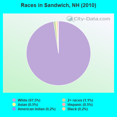
Races in Sandwich detailed stats: ancestries, foreign born residents, place of birth
Type |
2009 |
2010 |
2011 |
2012 |
2013 |
2014 |
2015 |
2016 |
2017 |
2018 |
2019 |
2020 |
2021 |
2022 |
|---|---|---|---|---|---|---|---|---|---|---|---|---|---|---|
| Murders (per 100,000) | 0 (0.0) | 0 (0.0) | 0 (0.0) | 0 (0.0) | 0 (0.0) | 0 (0.0) | 0 (0.0) | 0 (0.0) | 0 (0.0) | 0 (0.0) | 0 (0.0) | 0 (0.0) | 0 (0.0) | 0 (0.0) |
| Rapes (per 100,000) | 0 (0.0) | 0 (0.0) | 1 (75.3) | 0 (0.0) | 0 (0.0) | 0 (0.0) | 0 (0.0) | 0 (0.0) | 0 (0.0) | 0 (0.0) | 0 (0.0) | 0 (0.0) | 0 (0.0) | 0 (0.0) |
| Robberies (per 100,000) | 0 (0.0) | 0 (0.0) | 0 (0.0) | 0 (0.0) | 0 (0.0) | 0 (0.0) | 0 (0.0) | 0 (0.0) | 0 (0.0) | 0 (0.0) | 0 (0.0) | 0 (0.0) | 0 (0.0) | 0 (0.0) |
| Assaults (per 100,000) | 0 (0.0) | 0 (0.0) | 0 (0.0) | 1 (75.5) | 0 (0.0) | 0 (0.0) | 0 (0.0) | 0 (0.0) | 0 (0.0) | 2 (150.2) | 0 (0.0) | 1 (73.4) | 0 (0.0) | 0 (0.0) |
| Burglaries (per 100,000) | 5 (379.1) | 13 (980.4) | 14 (1,054) | 23 (1,737) | 5 (379.9) | 11 (835.9) | 7 (534.4) | 7 (535.6) | 5 (383.4) | 6 (450.5) | 2 (147.3) | 4 (293.7) | 3 (218.8) | 2 (127.1) |
| Thefts (per 100,000) | 26 (1,971) | 35 (2,640) | 27 (2,033) | 36 (2,719) | 23 (1,748) | 19 (1,444) | 17 (1,298) | 19 (1,454) | 17 (1,304) | 9 (675.7) | 11 (810.0) | 10 (734.2) | 7 (510.6) | 5 (317.9) |
| Auto thefts (per 100,000) | 0 (0.0) | 2 (150.8) | 0 (0.0) | 0 (0.0) | 0 (0.0) | 0 (0.0) | 1 (76.3) | 0 (0.0) | 0 (0.0) | 0 (0.0) | 0 (0.0) | 0 (0.0) | 0 (0.0) | 0 (0.0) |
| Arson (per 100,000) | 2 (151.6) | 0 (0.0) | 0 (0.0) | 1 (75.5) | 0 (0.0) | 0 (0.0) | 0 (0.0) | 0 (0.0) | 0 (0.0) | 0 (0.0) | 0 (0.0) | 0 (0.0) | 0 (0.0) | 0 (0.0) |
| City-Data.com crime index | 105.4 | 186.3 | 215.4 | 245.5 | 96.5 | 116.3 | 95.4 | 95.6 | 79.0 | 88.6 | 42.7 | 64.6 | 35.7 | 21.6 |
The City-Data.com crime index weighs serious crimes and violent crimes more heavily. Higher means more crime, U.S. average is 246.1. It adjusts for the number of visitors and daily workers commuting into cities.
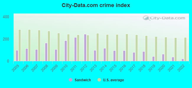
Crime rate in Sandwich detailed stats: murders, rapes, robberies, assaults, burglaries, thefts, arson
Full-time law enforcement employees in 2021, including police officers: 2 (2 officers - 2 male; 0 female).
| Officers per 1,000 residents here: | 1.46 |
| New Hampshire average: | 2.14 |
 Recent articles from our blog. Our writers, many of them Ph.D. graduates or candidates, create easy-to-read articles on a wide variety of topics.

 | Move to NH - Suggested Areas & Towns? (108 replies) |
| Why Isn't NH Population Booming? (110 replies) |
| Relocation suggestions (30 replies) |
| Sandwich New Hampshire (0 replies) |
| If you have ever been to Sandwich you probably have seen Issacs house (2 replies) |
| Why is N.H. so boring & unchanged? Let's change it! (66 replies) |
Latest news from Sandwich, NH collected exclusively by city-data.com from local newspapers, TV, and radio stations
Ancestries: English (41.1%), Irish (14.0%), German (12.7%), Scottish (10.8%), French (8.6%), Italian (6.1%).
Current Local Time: EST time zone
Incorporated in 1763
Elevation: 795 feet
Land area: 90.6 square miles.
Population density: 15 people per square mile (very low).
23 residents are foreign born
| This town: | 1.8% |
| New Hampshire: | 4.4% |
| Sandwich town: | 1.3% ($2,006) |
| New Hampshire: | 2.3% ($2,946) |
Nearest city with pop. 50,000+: Manchester, NH  (58.0 miles , pop. 107,006).
Nearest city with pop. 200,000+: Boston, MA (105.3 miles , pop. 589,141).
Nearest city with pop. 1,000,000+: Bronx, NY (240.9 miles , pop. 1,332,650).
Nearest cities:
), Latitude: 43.82 N, Longitude: 71.43 W
Area code commonly used in this area: 603

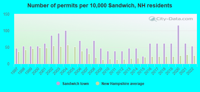
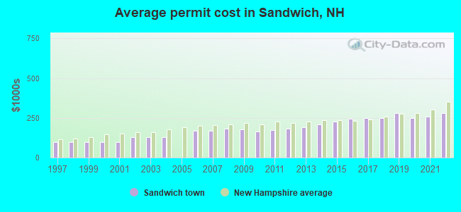
Single-family new house construction building permits:
- 2022: 7 buildings, average cost: $279,200
- 2021: 8 buildings, average cost: $259,200
- 2020: 15 buildings, average cost: $248,200
- 2019: 8 buildings, average cost: $282,200
- 2018: 8 buildings, average cost: $249,800
- 2017: 8 buildings, average cost: $248,100
- 2016: 8 buildings, average cost: $246,000
- 2015: 3 buildings, average cost: $226,800
- 2014: 6 buildings, average cost: $211,200
- 2013: 6 buildings, average cost: $193,300
- 2012: 5 buildings, average cost: $184,000
- 2011: 5 buildings, average cost: $172,800
- 2010: 5 buildings, average cost: $165,900
- 2009: 6 buildings, average cost: $178,900
- 2008: 9 buildings, average cost: $182,400
- 2007: 6 buildings, average cost: $171,000
- 2006: 9 buildings, average cost: $171,000
- 2004: 13 buildings, average cost: $130,700
- 2003: 12 buildings, average cost: $130,700
- 2002: 11 buildings, average cost: $130,700
- 2001: 8 buildings, average cost: $100,000
- 2000: 7 buildings, average cost: $100,000
- 1999: 7 buildings, average cost: $100,000
- 1998: 7 buildings, average cost: $100,000
- 1997: 6 buildings, average cost: $100,000
| Here: | 3.2% |
| New Hampshire: | 2.5% |
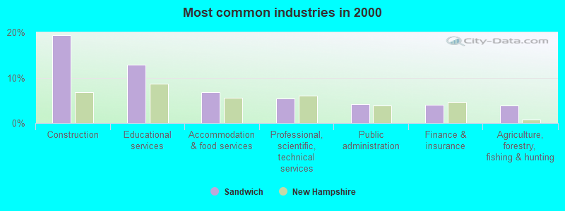
- Construction (19.4%)
- Educational services (12.8%)
- Accommodation & food services (6.8%)
- Professional, scientific, technical services (5.5%)
- Public administration (4.2%)
- Finance & insurance (4.0%)
- Agriculture, forestry, fishing & hunting (3.8%)
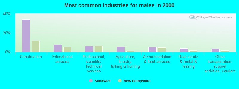
- Construction (34.2%)
- Educational services (7.7%)
- Professional, scientific, technical services (6.1%)
- Agriculture, forestry, fishing & hunting (5.5%)
- Accommodation & food services (4.8%)
- Real estate & rental & leasing (3.9%)
- Other transportation, support activities, couriers (3.5%)
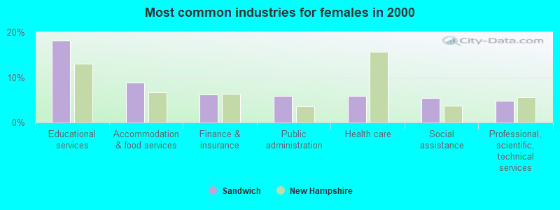
- Educational services (18.2%)
- Accommodation & food services (8.9%)
- Finance & insurance (6.2%)
- Public administration (5.8%)
- Health care (5.8%)
- Social assistance (5.5%)
- Professional, scientific, technical services (4.8%)
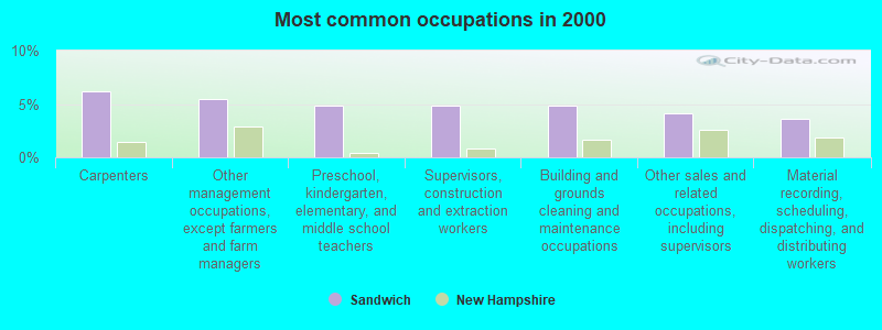
- Carpenters (6.1%)
- Other management occupations, except farmers and farm managers (5.5%)
- Preschool, kindergarten, elementary, and middle school teachers (4.8%)
- Supervisors, construction and extraction workers (4.8%)
- Building and grounds cleaning and maintenance occupations (4.8%)
- Other sales and related occupations, including supervisors (4.2%)
- Material recording, scheduling, dispatching, and distributing workers (3.7%)
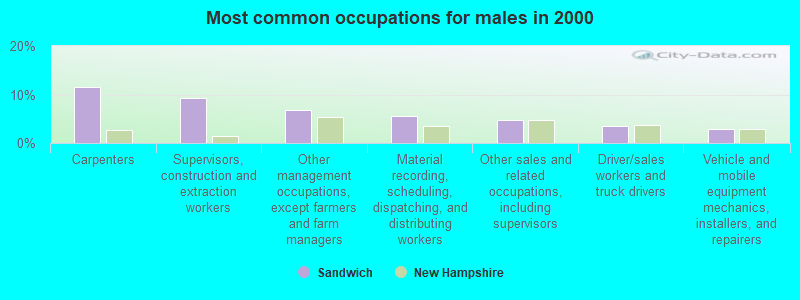
- Carpenters (11.6%)
- Supervisors, construction and extraction workers (9.4%)
- Other management occupations, except farmers and farm managers (6.8%)
- Material recording, scheduling, dispatching, and distributing workers (5.5%)
- Other sales and related occupations, including supervisors (4.8%)
- Driver/sales workers and truck drivers (3.5%)
- Vehicle and mobile equipment mechanics, installers, and repairers (2.9%)
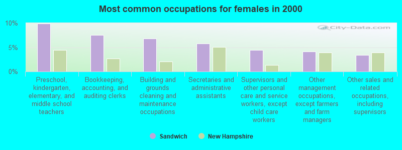
- Preschool, kindergarten, elementary, and middle school teachers (9.9%)
- Bookkeeping, accounting, and auditing clerks (7.5%)
- Building and grounds cleaning and maintenance occupations (6.8%)
- Secretaries and administrative assistants (5.8%)
- Supervisors and other personal care and service workers, except child care workers (4.5%)
- Other management occupations, except farmers and farm managers (4.1%)
- Other sales and related occupations, including supervisors (3.4%)
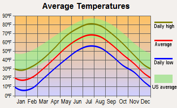
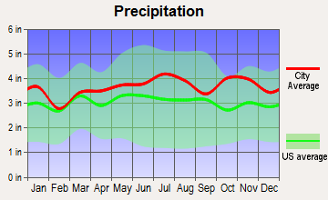
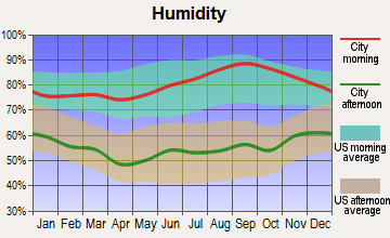
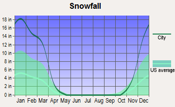
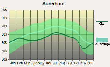
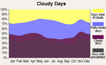
Average climate in Sandwich, New Hampshire
Based on data reported by over 4,000 weather stations

(lower is better)
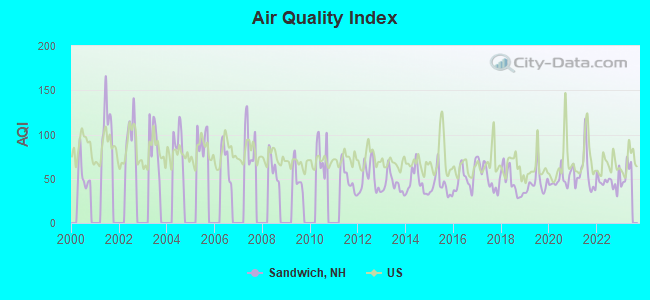
Air Quality Index (AQI) level in 2022 was 46.9. This is significantly better than average.
| City: | 46.9 |
| U.S.: | 72.6 |
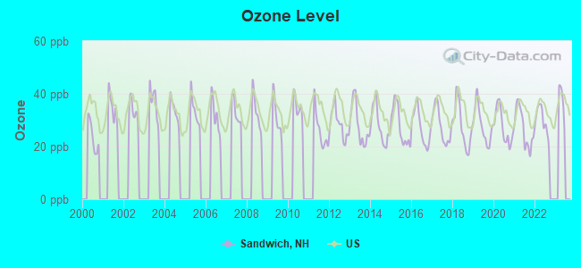
Ozone [ppb] level in 2022 was 29.8. This is about average. Closest monitor was 15.9 miles away from the city center.
| City: | 29.8 |
| U.S.: | 33.3 |
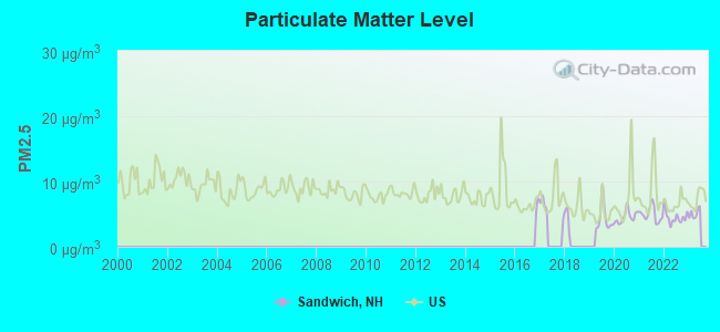
Particulate Matter (PM2.5) [µg/m3] level in 2022 was 4.52. This is significantly better than average. Closest monitor was 13.7 miles away from the city center.
| City: | 4.52 |
| U.S.: | 8.11 |
Tornado activity:
Sandwich-area historical tornado activity is below New Hampshire state average. It is 70% smaller than the overall U.S. average.
On 7/18/1963, a category F2 (max. wind speeds 113-157 mph) tornado 19.3 miles away from the Sandwich town center caused between $5000 and $50,000 in damages.
On 7/3/1972, a category F2 tornado 28.0 miles away from the town center injured 7 people and caused between $5000 and $50,000 in damages.
Earthquake activity:
Sandwich-area historical earthquake activity is significantly above New Hampshire state average. It is 72% smaller than the overall U.S. average.On 4/20/2002 at 10:50:47, a magnitude 5.3 (5.3 ML, Depth: 3.0 mi, Class: Moderate, Intensity: VI - VII) earthquake occurred 122.2 miles away from Sandwich center
On 4/20/2002 at 10:50:47, a magnitude 5.2 (5.2 MB, 4.2 MS, 5.2 MW, 5.0 MW) earthquake occurred 122.5 miles away from Sandwich center
On 10/7/1983 at 10:18:46, a magnitude 5.3 (5.1 MB, 5.3 LG, 5.1 ML) earthquake occurred 145.5 miles away from the city center
On 1/19/1982 at 00:14:42, a magnitude 4.7 (4.5 MB, 4.7 MD, 4.5 LG, Class: Light, Intensity: IV - V) earthquake occurred 24.0 miles away from Sandwich center
On 10/16/2012 at 23:12:25, a magnitude 4.7 (4.7 ML, Depth: 10.0 mi) earthquake occurred 41.7 miles away from the city center
On 8/21/1996 at 07:54:14, a magnitude 3.8 (3.8 LG, 3.6 LG, Depth: 6.2 mi, Class: Light, Intensity: II - III) earthquake occurred 25.2 miles away from Sandwich center
Magnitude types: regional Lg-wave magnitude (LG), body-wave magnitude (MB), duration magnitude (MD), local magnitude (ML), surface-wave magnitude (MS), moment magnitude (MW)
Natural disasters:
The number of natural disasters in Carroll County (29) is a lot greater than the US average (15).Major Disasters (Presidential) Declared: 17
Emergencies Declared: 9
Causes of natural disasters: Storms: 12, Floods: 11, Winter Storms: 5, Hurricanes: 4, Snows: 4, Snowstorms: 2, Blizzard: 1, Heavy Rain: 1, Ice Storm: 1, Snowfall: 1, Tornado: 1, Tropical Storm: 1, Wind: 1, Other: 1 (Note: some incidents may be assigned to more than one category).

Colleges/universities with over 2000 students nearest to Sandwich:
- Plymouth State University (about 14 miles; Plymouth, NH; Full-time enrollment: 4,838)
- NHTI-Concord's Community College (about 42 miles; Concord, NH; FT enrollment: 2,865)
- Dartmouth College (about 44 miles; Hanover, NH; FT enrollment: 6,030)
- Saint Joseph's College of Maine (about 48 miles; Standish, ME; FT enrollment: 2,010)
- University of New Hampshire-Main Campus (about 54 miles; Durham, NH; FT enrollment: 15,243)
- Southern New Hampshire University (about 55 miles; Manchester, NH; FT enrollment: 16,552)
- University of New England (about 59 miles; Biddeford, ME; FT enrollment: 4,539)
Points of interest:
Notable locations in Sandwich: Black Mountain Pond Shelter (A), Mead Wilderness Base Organization Camp (B), Camp Hale (C), Sandwich Fairgrounds (D), Sandwich Fire Rescue Department Central Station (E), Sandwich Fire Rescue Department White Face Station (F). Display/hide their locations on the map
Churches in Sandwich include: Friends Church (A), East Sandwich Chapel (B), White Church (C), Federated Church (D). Display/hide their locations on the map
Cemeteries: Little Pond Cemetery (1), Hubbard Cemetery (2), Elm Hill Cemetery (3), Grove Cemetery (4). Display/hide their locations on the map
Lakes: Hall Ponds (A), Intervale Pond (B), Kiah Pond (C), Kusumpe Pond (D), Teacup Lake (E), Little Pond (F), Miles Pond (G), Barville Pond (H). Display/hide their locations on the map
Streams, rivers, and creeks: White Brook (A), Whiteface River (B), Heath Brook (C), Pond Brook (D), Meadow Brook (E), Burrows Brook (F), Eastman Brook (G), Cook Brook (H), Captain Neal Brook (I). Display/hide their locations on the map
Parks in Sandwich include: Center Sandwich Historic District (1), Lower Corner Historic District (2), Thompson Sanctuary (3). Display/hide their locations on the map
Birthplace of: John Wentworth (mayor).
| This town: | 2.1 people |
| New Hampshire: | 2.5 people |
| This town: | 65.6% |
| Whole state: | 66.3% |
| This town: | 6.6% |
| Whole state: | 8.3% |
Likely homosexual households (counted as self-reported same-sex unmarried-partner households)
- Lesbian couples: 0.3% of all households
- Gay men: 0.2% of all households
| This town: | 6.1% |
| Whole state: | 6.5% |
| This town: | 2.3% |
| Whole state: | 2.8% |
For population 15 years and over in Sandwich:
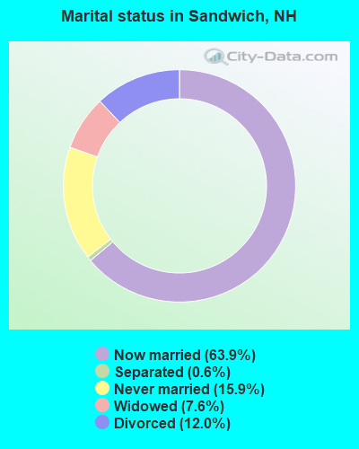
- Never married: 15.9%
- Now married: 63.9%
- Separated: 0.6%
- Widowed: 7.6%
- Divorced: 12.0%
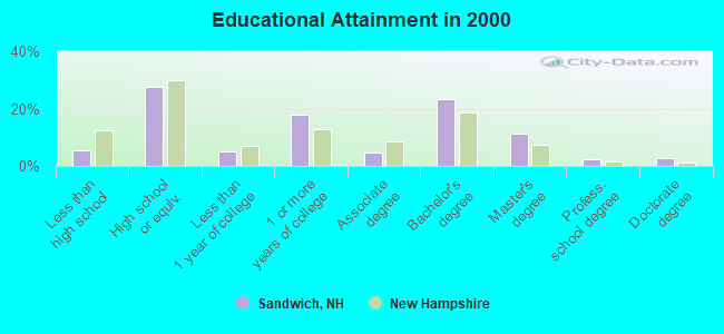
For population 25 years and over in Sandwich:
- High school or higher: 94.6%
- Bachelor's degree or higher: 39.7%
- Graduate or professional degree: 16.4%
- Unemployed: 1.5%
- Mean travel time to work (commute): 27.0 minutes
| Here: | 10.4 |
| New Hampshire average: | 10.9 |
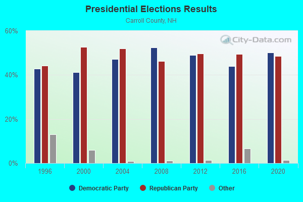
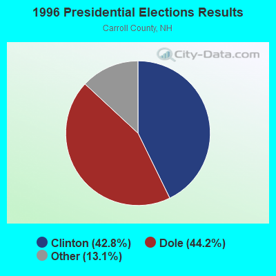
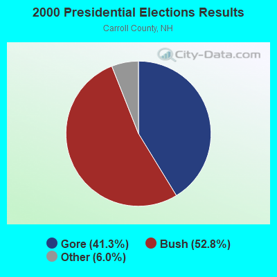

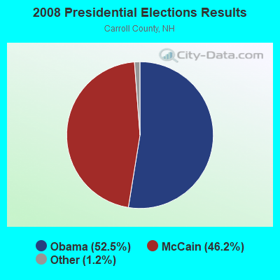
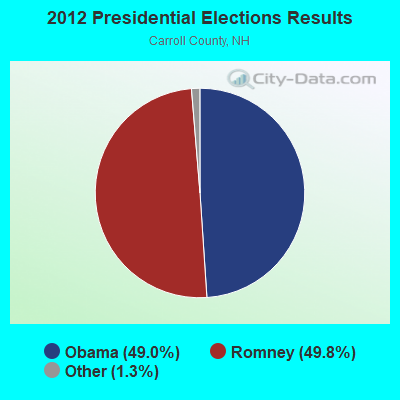
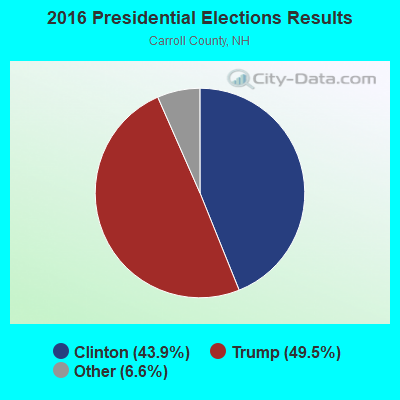
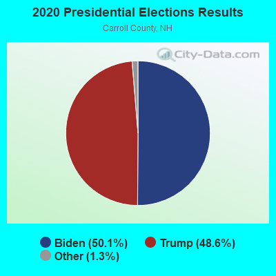
Graphs represent county-level data. Detailed 2008 Election Results
Religion statistics for Sandwich, NH (based on Carroll County data)
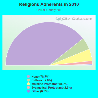
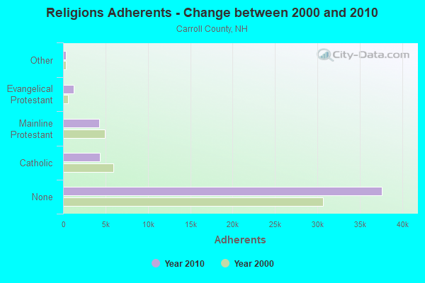
| Religion | Adherents | Congregations |
|---|---|---|
| Catholic | 4,304 | 2 |
| Mainline Protestant | 4,266 | 30 |
| Evangelical Protestant | 1,241 | 14 |
| Other | 366 | 5 |
| None | 37,641 | - |
Food Environment Statistics:
| Carroll County: | 4.23 / 10,000 pop. |
| New Hampshire: | 2.14 / 10,000 pop. |
| Carroll County: | 2.54 / 10,000 pop. |
| New Hampshire: | 1.78 / 10,000 pop. |
| Here: | 8.47 / 10,000 pop. |
| New Hampshire: | 4.02 / 10,000 pop. |
| Carroll County: | 24.13 / 10,000 pop. |
| New Hampshire: | 9.70 / 10,000 pop. |
| Carroll County: | 8.8% |
| State: | 7.6% |
| Carroll County: | 21.2% |
| State: | 24.4% |
| Carroll County: | 16.9% |
| New Hampshire: | 15.9% |
Businesses in Sandwich, NH
- MasterBrand Cabinets: 2
Strongest AM radio stations in Sandwich:
- WPNH (1300 AM; 5 kW; PLYMOUTH, NH; Owner: NORTHEAST COMMUNICATIONS CORPORATION)
- WASR (1420 AM; 5 kW; WOLFEBORO, NH; Owner: RADIO WOLFEBORO, INC.)
- WRKO (680 AM; 50 kW; BOSTON, MA; Owner: ENTERCOM BOSTON LICENSE, LLC)
- WEZS (1350 AM; 5 kW; LACONIA, NH; Owner: GARY W. HAMMOND)
- WGIN (930 AM; 10 kW; ROCHESTER, NH; Owner: CAPSTAR TX LIMITED PARTNERSHIP)
- WEEI (850 AM; 50 kW; BOSTON, MA; Owner: ENTERCOM BOSTON LICENSE, LLC)
- WMTW (870 AM; 10 kW; GORHAM, ME; Owner: RADIO PARTNERS OF MAINE, L.P.)
- WCRN (830 AM; 50 kW; WORCESTER, MA; Owner: CARTER BROADCASTING CORPORATION)
- WNNZ (640 AM; 50 kW; WESTFIELD, MA; Owner: CLEAR CHANNEL BROADCASTING LICENSES, INC.)
- WNTK (1020 AM; 10 kW; NEWPORT, NH; Owner: KOOR COMMUNICATIONS, INC.)
- WBZ (1030 AM; 50 kW; BOSTON, MA; Owner: INFINITY BROADCASTING OPERATIONS, INC.)
- WKOX (1200 AM; 50 kW; FRAMINGHAM, MA; Owner: CAPSTAR TX LIMITED PARTNERSHIP)
- WWZN (1510 AM; 50 kW; BOSTON, MA; Owner: ROSE CITY RADIO CORPORATION)
Strongest FM radio stations in Sandwich:
- WSCY (106.9 FM; MOULTONBOROUGH, NH; Owner: NORTHEAST COMMUNICATIONS CORPORATION)
- WVFM (105.7 FM; CAMPTON, NH; Owner: DEVON BROADCASTING COMPANY, INC.)
- WPKQ (103.7 FM; NORTH CONWAY, NH; Owner: CITADEL BROADCASTING COMPANY)
- WHOM (94.9 FM; MT. WASHINGTON, NH; Owner: CITADEL BROADCASTING COMPANY)
- WPNH-FM (100.1 FM; PLYMOUTH, NH; Owner: NORTHEAST COMMUNICATIONS CORPORATION)
- WLKZ (104.9 FM; WOLFEBORO, NH; Owner: TELE-MEDIA COMPANY OF NEW HAMPSHIRE, L.L.C.)
- WMEA (90.1 FM; PORTLAND, ME; Owner: MAINE PUBLIC BROADCASTING CORPORATION)
- WHDQ (106.1 FM; CLAREMONT, NH; Owner: GREAT NORTHERN RADIO, L.L.C.)
- WNHI (93.3 FM; BELMONT, NH; Owner: CONCORD BROADCASTING, L.L.C.)
- WLNH-FM (98.3 FM; LACONIA, NH; Owner: WLNH RADIO, INC)
- WEVH (91.3 FM; HANOVER, NH; Owner: NEW HAMPSHIRE PUBLIC RADIO INC)
- WMWV (93.5 FM; CONWAY, NH; Owner: MT. WASHINGTON RADIO & GRAMOPHONE, L.L.C.)
- WVPR (89.5 FM; WINDSOR, VT; Owner: VERMONT PUBLIC RADIO)
- WGMT (97.7 FM; LYNDON, VT; Owner: VERMONT BROADCAST ASSOCIATES, INC.)
- WMTK (106.3 FM; LITTLETON, NH; Owner: VERMONT BROADCAST ASSOCIATES, INC.)
- WJJR (98.1 FM; RUTLAND, VT; Owner: 6 JOHNSON ROAD LICENSES, INC.)
- WZRT (97.1 FM; RUTLAND, VT; Owner: CAPSTAR TX LIMITED PARTNERSHIP)
- WEBK (105.3 FM; KILLINGTON, VT; Owner: 6 JOHNSON ROAD LICENSES, INC.)
- WVMJ (104.5 FM; CONWAY, NH; Owner: MT. WASHINGTON RADIO & GRAMOPHONE, L.L.C.)
- WBLM (102.9 FM; PORTLAND, ME; Owner: CITADEL BROADCASTING COMPANY)
TV broadcast stations around Sandwich:
- WMTW-TV (Channel 8; POLAND SPRING, ME; Owner: WMTW BROADCAST GROUP, LLC)
- WCSH (Channel 6; PORTLAND, ME; Owner: PACIFIC AND SOUTHERN COMPANY, INC.)
- WMEA-TV (Channel 26; BIDDEFORD, ME; Owner: MAINE PUBLIC BROADCASTING CORP.)
- WGME-TV (Channel 13; PORTLAND, ME; Owner: WGME LICENSEE, LLC)
- Sandwich, New Hampshire
- Fatal accident count9
- Vehicles involved in fatal accidents11
- Fatal accidents involving drunk persons:4
- Fatalities9
- Persons involved in fatal accidents19
- Pedestrians involved in fatal accidents0
- New Hampshire average
- Fatal accident count1016
- Vehicles involved in fatal accidents1514
- Fatal accidents involving drunk persons377
- Fatalities1112
- Persons involved in fatal accidents2358
- Pedestrians involved in fatal accidents77
- National Bridge Inventory (NBI) Statistics
- 18Number of bridges
- 89ft / 27.0mTotal length
- $56,556,000Total costs
- 3,026Total average daily traffic
- 226Total average daily truck traffic
- 4,466Total future (year 2042) average daily traffic
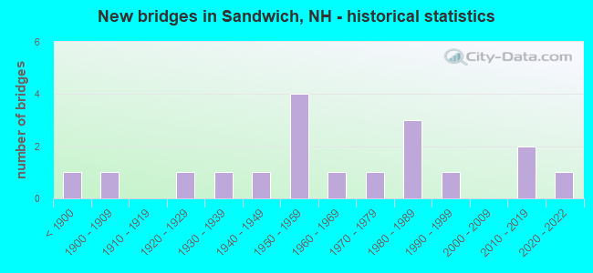
- New bridges - historical statistics
- 1Before 1900
- 11900-1909
- 11920-1929
- 11930-1939
- 11940-1949
- 41950-1959
- 11960-1969
- 11970-1979
- 31980-1989
- 11990-1999
- 22010-2019
- 12020-2022
FCC Registered Antenna Towers:
14 (See the full list of FCC Registered Antenna Towers in Sandwich)FCC Registered Broadcast Land Mobile Towers:
2- Fire Station Rt 109 Near Rt 113 (Lat: 43.808417 Lon: -71.438139), Call Sign: KLI380,
Assigned Frequencies: 33.9000 MHz, Grant Date: 01/09/2003, Expiration Date: 03/23/2013, Cancellation Date: 05/25/2013, Registrant: Federal Licensing Inc, 1588 Fairfield Rd, Gettysburg, PA 17325, Phone: (717) 334-9262, Fax: (717) 334-6440
- Village Fire Dept Church St (Lat: 43.807306 Lon: -71.437028), Call Sign: KCI318, Licensee ID: L00008549,
Assigned Frequencies: 31.9000 MHz, Grant Date: 08/08/2001, Expiration Date: 09/18/2011, Cancellation Date: 11/19/2003, Registrant: The State Of New Hampshire, Department Of Resources And Economic Development, 172 Pembroke Road, Concord, NH 03302-1856, Phone: (603) 271-2217, Fax: (603) 271-6488, Email:
FCC Registered Amateur Radio Licenses:
3- Call Sign: K1ZKJ, Licensee ID: L00298515, Grant Date: 01/09/2015, Expiration Date: 03/17/2025, Certifier: William T Gill Iii, Registrant: William T Gill Iii, 250 Mountain Rd, Sandwich, NH 03227
- Call Sign: KA1EIJ, Licensee ID: L01095098, Grant Date: 12/22/2015, Expiration Date: 02/16/2026, Certifier: Donald R Casey, Registrant: Donald R Casey, 147 Mountain Rd, Sandwich, NH 03227
- Call Sign: KB1OKK, Licensee ID: L01240256, Grant Date: 11/08/2016, Expiration Date: 01/29/2027, Certifier: Louis G Brunelle, Registrant: Louis G Brunelle, 32 Palmer Hill Rd, Sandwich, NH 03227
FAA Registered Aircraft:
1- Aircraft: MOONEY M20E (Category: Land, Seats: 4, Weight: Up to 12,499 Pounds, Speed: 127 mph), Engine: LYCOMING I0360 SER (180 HP) (Reciprocating)
N-Number: 201DY, N201DY, N-201DY, Serial Number: 857, Year manufactured: 1965, Airworthiness Date: 10/13/1965, Certificate Issue Date: 02/06/2019
Registrant (Individual): Alexander M Michaelis, 34 Frog Pond Rd, Sandwich, NH 03227
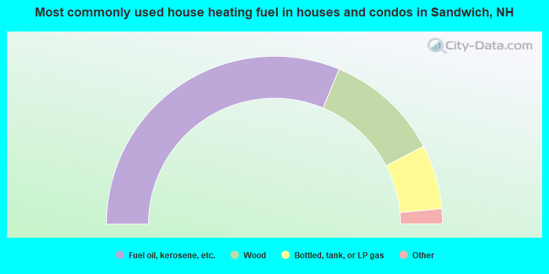
- 62.6%Fuel oil, kerosene, etc.
- 22.1%Wood
- 12.4%Bottled, tank, or LP gas
- 1.3%Electricity
- 1.1%Coal or coke
- 0.4%Solar energy
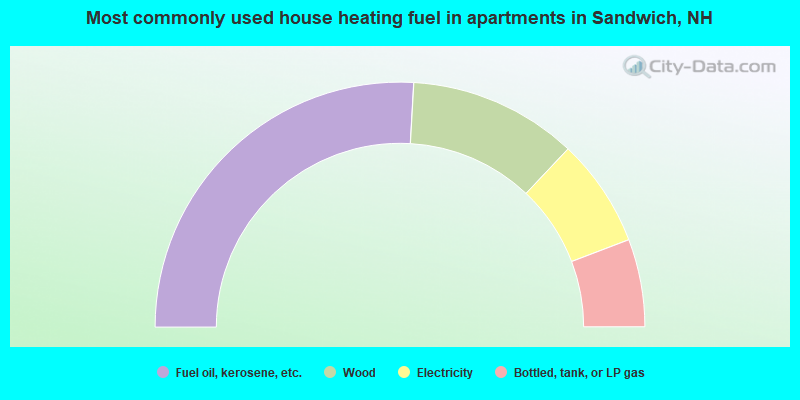
- 51.8%Fuel oil, kerosene, etc.
- 22.3%Wood
- 14.3%Electricity
- 11.6%Bottled, tank, or LP gas
Sandwich compared to New Hampshire state average:
- Unemployed percentage significantly below state average.
- Black race population percentage significantly below state average.
- Hispanic race population percentage significantly below state average.
- Median age significantly above state average.
- Foreign-born population percentage significantly below state average.
- Renting percentage below state average.
- Length of stay since moving in significantly above state average.
- Number of rooms per house significantly below state average.
- House age significantly below state average.
- Number of college students below state average.

|
Total of 2 patent applications in 2008-2024.