Sebago, Maine


Submit your own pictures of this town and show them to the world
- OSM Map
- Google Map
- MSN Map
Population change since 2000: +20.0%
 |
| Males: 880 | |
| Females: 839 |
| Median resident age: | 44.7 years |
| Maine median age: | 43.0 years |
Zip codes: 04029.
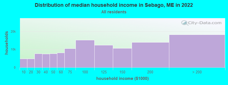
| Sebago: | $81,927 |
| ME: | $69,543 |
Estimated per capita income in 2022: $43,678 (it was $18,995 in 2000)
Sebago town income, earnings, and wages data
Estimated median house or condo value in 2022: $355,067 (it was $104,200 in 2000)
| Sebago: | $355,067 |
| ME: | $290,600 |
Mean prices in 2022: all housing units: $514,200; detached houses: $533,395; townhouses or other attached units: $572,947; in 2-unit structures: $538,406; in 3-to-4-unit structures: $462,507; in 5-or-more-unit structures: $450,834; mobile homes: $93,551
Detailed information about poverty and poor residents in Sebago, ME


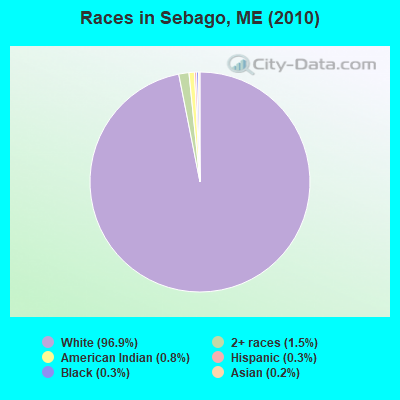
- 1,66696.9%White alone
- 251.5%Two or more races
- 140.8%American Indian alone
- 50.3%Black alone
- 60.3%Hispanic
- 30.2%Asian alone
Races in Sebago detailed stats: ancestries, foreign born residents, place of birth
According to our research of Maine and other state lists, there were 7 registered sex offenders living in Sebago, Maine as of April 29, 2024.
The ratio of all residents to sex offenders in Sebago is 246 to 1.
 Recent articles from our blog. Our writers, many of them Ph.D. graduates or candidates, create easy-to-read articles on a wide variety of topics.
Ancestries: English (18.1%), Irish (17.2%), United States (12.4%), German (10.1%), French (8.9%), Italian (6.7%).
Current Local Time: EST time zone
Incorporated on 02/10/1826
Land area: 32.8 square miles.
Population density: 52 people per square mile (very low).
24 residents are foreign born
| This town: | 1.7% |
| Maine: | 2.9% |
| Sebago town: | 1.2% ($1,239) |
| Maine: | 1.5% ($1,417) |
Nearest city with pop. 50,000+: Portland, ME  (25.5 miles , pop. 64,249).
Nearest city with pop. 200,000+: Boston, MA (110.3 miles , pop. 589,141).
Nearest city with pop. 1,000,000+: Bronx, NY (266.2 miles , pop. 1,332,650).
Nearest cities:
), Latitude: 43.89 N, Longitude: 70.68 W
Area code: 207
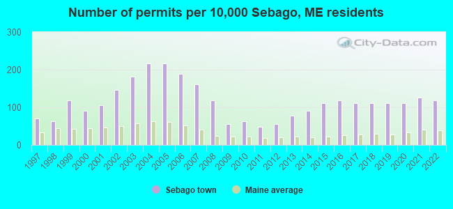
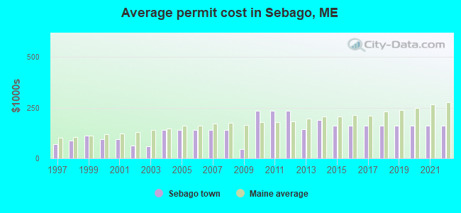
Single-family new house construction building permits:
- 2022: 17 buildings, average cost: $162,500
- 2021: 18 buildings, average cost: $162,500
- 2020: 16 buildings, average cost: $162,500
- 2019: 16 buildings, average cost: $162,500
- 2018: 16 buildings, average cost: $162,500
- 2017: 16 buildings, average cost: $162,500
- 2016: 17 buildings, average cost: $162,500
- 2015: 16 buildings, average cost: $162,500
- 2014: 13 buildings, average cost: $191,200
- 2013: 11 buildings, average cost: $145,000
- 2012: 8 buildings, average cost: $236,100
- 2011: 7 buildings, average cost: $236,100
- 2010: 9 buildings, average cost: $236,100
- 2009: 8 buildings, average cost: $46,800
- 2008: 17 buildings, average cost: $140,600
- 2007: 23 buildings, average cost: $140,600
- 2006: 27 buildings, average cost: $140,600
- 2005: 31 buildings, average cost: $140,600
- 2004: 31 buildings, average cost: $140,600
- 2003: 26 buildings, average cost: $58,700
- 2002: 21 buildings, average cost: $61,900
- 2001: 15 buildings, average cost: $95,000
- 2000: 13 buildings, average cost: $95,000
- 1999: 17 buildings, average cost: $112,200
- 1998: 9 buildings, average cost: $86,100
- 1997: 10 buildings, average cost: $69,100
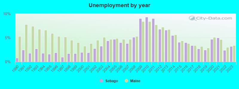
| Here: | 3.2% |
| Maine: | 3.4% |
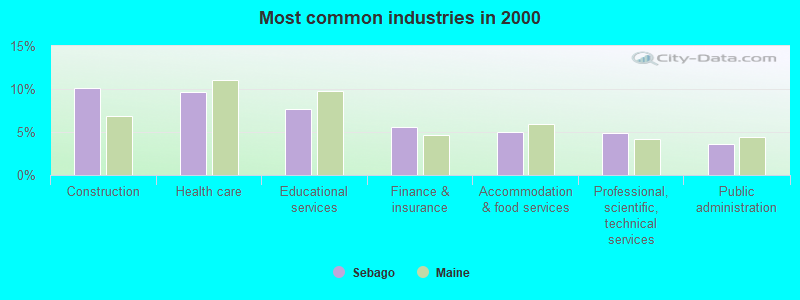
- Construction (10.1%)
- Health care (9.7%)
- Educational services (7.7%)
- Finance & insurance (5.5%)
- Accommodation & food services (5.0%)
- Professional, scientific, technical services (4.9%)
- Public administration (3.6%)
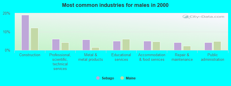
- Construction (19.0%)
- Professional, scientific, technical services (6.0%)
- Metal & metal products (5.7%)
- Educational services (4.9%)
- Accommodation & food services (4.9%)
- Repair & maintenance (4.2%)
- Public administration (4.2%)
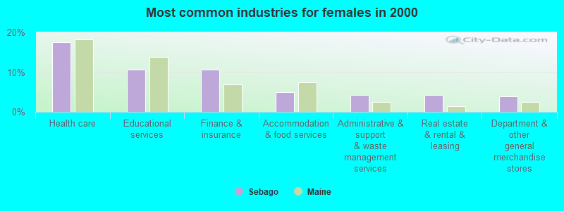
- Health care (17.6%)
- Educational services (10.6%)
- Finance & insurance (10.6%)
- Accommodation & food services (5.0%)
- Administrative & support & waste management services (4.2%)
- Real estate & rental & leasing (4.2%)
- Department & other general merchandise stores (3.9%)
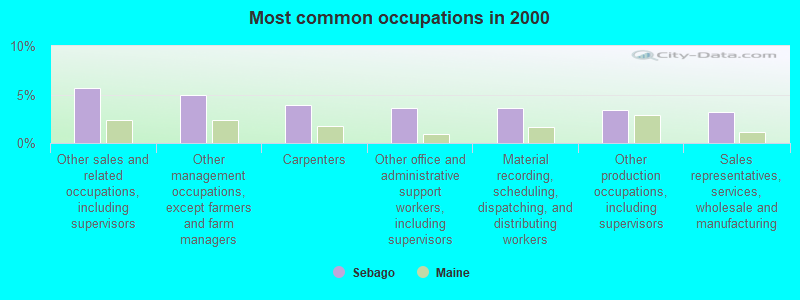
- Other sales and related occupations, including supervisors (5.7%)
- Other management occupations, except farmers and farm managers (5.0%)
- Carpenters (3.9%)
- Other office and administrative support workers, including supervisors (3.6%)
- Material recording, scheduling, dispatching, and distributing workers (3.6%)
- Other production occupations, including supervisors (3.4%)
- Sales representatives, services, wholesale and manufacturing (3.2%)
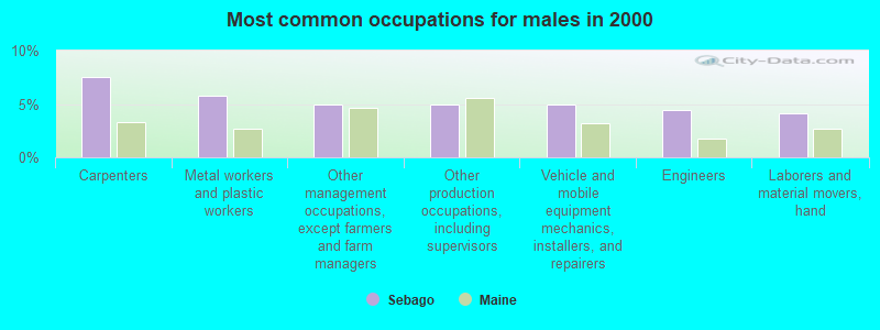
- Carpenters (7.6%)
- Metal workers and plastic workers (5.7%)
- Other management occupations, except farmers and farm managers (4.9%)
- Other production occupations, including supervisors (4.9%)
- Vehicle and mobile equipment mechanics, installers, and repairers (4.9%)
- Engineers (4.4%)
- Laborers and material movers, hand (4.2%)

- Other sales and related occupations, including supervisors (7.8%)
- Secretaries and administrative assistants (5.9%)
- Other office and administrative support workers, including supervisors (5.3%)
- Other management occupations, except farmers and farm managers (5.0%)
- Material recording, scheduling, dispatching, and distributing workers (4.5%)
- Preschool, kindergarten, elementary, and middle school teachers (4.5%)
- Bookkeeping, accounting, and auditing clerks (4.2%)
Average climate in Sebago, Maine
Based on data reported by over 4,000 weather stations


(lower is better)
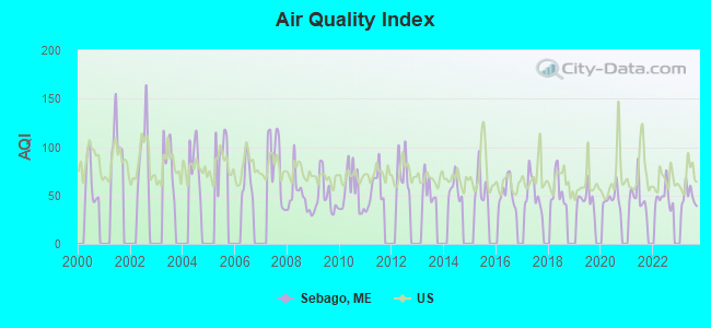
Air Quality Index (AQI) level in 2023 was 48.8. This is significantly better than average.
| City: | 48.8 |
| U.S.: | 72.6 |
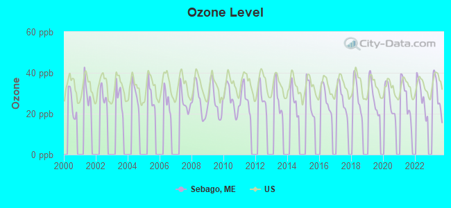
Ozone [ppb] level in 2023 was 29.7. This is about average. Closest monitor was 15.0 miles away from the city center.
| City: | 29.7 |
| U.S.: | 33.3 |
Tornado activity:
Sebago-area historical tornado activity is above Maine state average. It is 75% smaller than the overall U.S. average.
On 10/10/1966, a category F2 (max. wind speeds 113-157 mph) tornado 32.0 miles away from the Sebago town center caused between $5000 and $50,000 in damages.
On 7/18/1963, a category F2 tornado 32.8 miles away from the town center caused between $5000 and $50,000 in damages.
Earthquake activity:
Sebago-area historical earthquake activity is significantly above Maine state average. It is 74% smaller than the overall U.S. average.On 10/16/2012 at 23:12:25, a magnitude 4.7 (4.7 ML, Depth: 10.0 mi, Class: Light, Intensity: IV - V) earthquake occurred 20.1 miles away from the city center
On 4/20/2002 at 10:50:47, a magnitude 5.3 (5.3 ML, Depth: 3.0 mi, Class: Moderate, Intensity: VI - VII) earthquake occurred 155.8 miles away from Sebago center
On 4/20/2002 at 10:50:47, a magnitude 5.2 (5.2 MB, 4.2 MS, 5.2 MW, 5.0 MW) earthquake occurred 156.4 miles away from Sebago center
On 1/19/1982 at 00:14:42, a magnitude 4.7 (4.5 MB, 4.7 MD, 4.5 LG) earthquake occurred 53.3 miles away from the city center
On 10/7/1983 at 10:18:46, a magnitude 5.3 (5.1 MB, 5.3 LG, 5.1 ML) earthquake occurred 182.6 miles away from the city center
On 8/21/1996 at 07:54:14, a magnitude 3.8 (3.8 LG, 3.6 LG, Depth: 6.2 mi, Class: Light, Intensity: II - III) earthquake occurred 39.3 miles away from Sebago center
Magnitude types: regional Lg-wave magnitude (LG), body-wave magnitude (MB), duration magnitude (MD), local magnitude (ML), surface-wave magnitude (MS), moment magnitude (MW)
Natural disasters:
The number of natural disasters in Cumberland County (33) is a lot greater than the US average (15).Major Disasters (Presidential) Declared: 22
Emergencies Declared: 10
Causes of natural disasters: Floods: 19, Storms: 13, Snows: 7, Winter Storms: 6, Heavy Rains: 3, Hurricanes: 3, Winds: 3, Blizzard: 1, Ice Storm: 1, Mudslide: 1, Snowfall: 1, Snowstorm: 1, Tornado: 1, Other: 2 (Note: some incidents may be assigned to more than one category).
Colleges/universities with over 2000 students nearest to Sebago:
- Saint Joseph's College of Maine (about 11 miles; Standish, ME; Full-time enrollment: 2,010)
- University of Southern Maine (about 26 miles; Portland, ME; FT enrollment: 6,647)
- Southern Maine Community College (about 28 miles; South Portland, ME; FT enrollment: 4,666)
- University of New England (about 34 miles; Biddeford, ME; FT enrollment: 4,539)
- Plymouth State University (about 52 miles; Plymouth, NH; FT enrollment: 4,838)
- University of New Hampshire-Main Campus (about 54 miles; Durham, NH; FT enrollment: 15,243)
- University of Maine at Augusta (about 54 miles; Augusta, ME; FT enrollment: 3,204)
Public elementary/middle school in Sebago:
- SEBAGO ELEMENTARY SCHOOL (Location: 283 SEBAGO ROAD, Grades: KG-5)
Points of interest:
Notable locations in Sebago: Hemlock Hills Campground (A), Camp Winaco (B), Camp O-At-Ka (C), Sebago Fire Department Station 2 (D), Sebago Volunteer Emergency Medical Services (E), Spaulding Memorial Library (F), Sebago Fire Department Station 1 (G), Sebago Fire Department Station 3 (H). Display/hide their locations on the map
Church in Sebago: Sebago Center Community Church (A). Display/hide its location on the map
Cemeteries: Poor Cemetery (1), Pike Cemetery (2), Fitch Cemetery (3), Martin Cemetery (4), Lakeside Cemetery (5), Kenison Cemetery (6), Jewell Cemetery (7). Display/hide their locations on the map
Lakes and reservoirs: Mariner Pond (A), Browns Pond (B), Perley Pond (C), Fitch Mill Pond (D), Peabody Pond (E). Display/hide their locations on the map
Streams, rivers, and creeks: Northwest River (A), Bachelder Brook (B), Hill Brook (C), Douglass Brook (D), Hanson Brook (E), Lakin Brook (F), Mill Brook (G), Nason Brook (H). Display/hide their locations on the map
Drinking water stations with addresses in Sebago and their reported violations in the past:
NASONS BEACH CAMPGROUND (Population served: 125, Groundwater):Past health violations:CAMP O-AT-KA - BUNGALOW SYSTEM (Address: 593 SEBAGO RD , Population served: 100, Groundwater):Past monitoring violations:
- MCL, Monthly (TCR) - In JUN-2013, Contaminant: Coliform. Follow-up actions: St Formal NOV issued (JUN-25-2013), St Public Notif requested (JUN-25-2013)
- MCL, Monthly (TCR) - In MAY-2013, Contaminant: Coliform. Follow-up actions: St Public Notif requested (MAY-29-2013), St Formal NOV issued (MAY-29-2013), St Public Notif received (JUN-06-2013)
- MCL, Monthly (TCR) - In MAY-2007, Contaminant: Coliform. Follow-up actions: St Public Notif requested (JUN-04-2007), St Violation/Reminder Notice (JUN-04-2007), St Public Notif received (JUN-18-2007), St Compliance achieved (SEP-10-2007)
- One routine major monitoring violation
Past monitoring violations:CAMP O-AT-KA- ANDERSON SYSTEM (Address: 593 SEBAGO RD , Population served: 100, Groundwater):
- One regular monitoring violation
Past health violations:SEBAGO LAKE CAMPS INC (Population served: 40, Groundwater):Past monitoring violations:
- MCL, Monthly (TCR) - In SEP-2012, Contaminant: Coliform. Follow-up actions: St Public Notif requested (OCT-30-2012), St Formal NOV issued (OCT-30-2012), St Public Notif received (NOV-08-2012)
- One regular monitoring violation
Past monitoring violations:ROUND TABLE LODGE & COTTAGES (Population served: 35, Groundwater):
- 6 routine major monitoring violations
- One regular monitoring violation
Past monitoring violations:
- 3 regular monitoring violations
| This town: | 2.4 people |
| Maine: | 2.3 people |
| This town: | 66.9% |
| Whole state: | 62.9% |
| This town: | 8.8% |
| Whole state: | 9.4% |
Likely homosexual households (counted as self-reported same-sex unmarried-partner households)
- Lesbian couples: 0.4% of all households
- Gay men: 0.1% of all households
| This town: | 5.8% |
| Whole state: | 10.9% |
| This town: | 0.9% |
| Whole state: | 4.1% |
For population 15 years and over in Sebago:
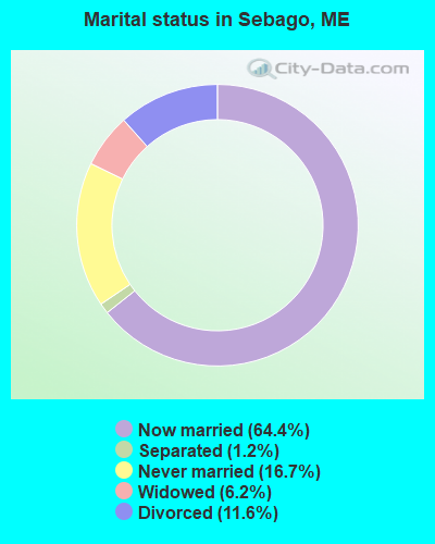
- Never married: 16.7%
- Now married: 64.4%
- Separated: 1.2%
- Widowed: 6.2%
- Divorced: 11.6%
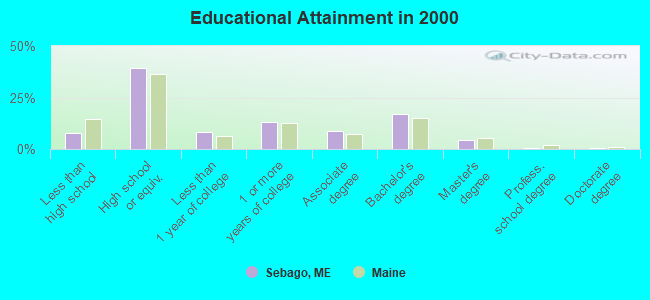
For population 25 years and over in Sebago:
- High school or higher: 92.1%
- Bachelor's degree or higher: 22.2%
- Graduate or professional degree: 5.3%
- Unemployed: 3.0%
- Mean travel time to work (commute): 36.5 minutes
| Here: | 8.7 |
| Maine average: | 11.2 |
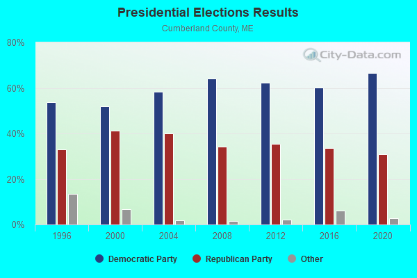
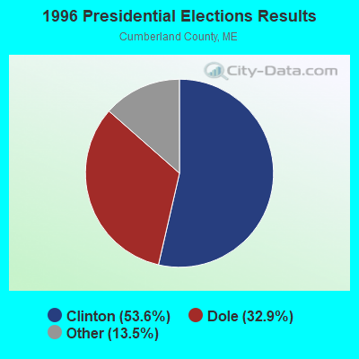
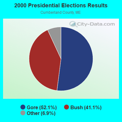
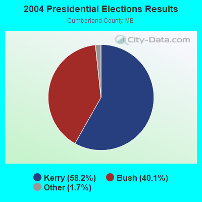
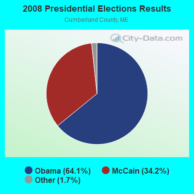
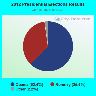

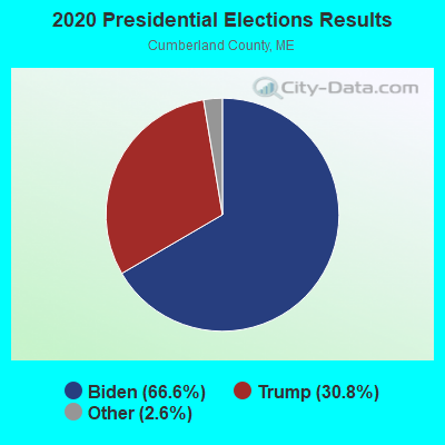
Graphs represent county-level data. Detailed 2008 Election Results
Religion statistics for Sebago, ME (based on Cumberland County data)
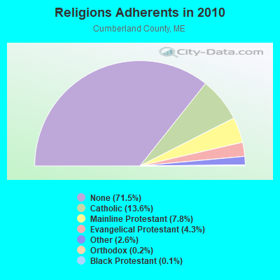
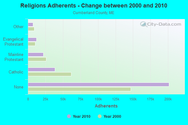
| Religion | Adherents | Congregations |
|---|---|---|
| Catholic | 38,243 | 19 |
| Mainline Protestant | 22,030 | 96 |
| Evangelical Protestant | 12,007 | 85 |
| Other | 7,187 | 44 |
| Orthodox | 500 | 1 |
| Black Protestant | 285 | 2 |
| None | 201,422 | - |
Food Environment Statistics:
| This county: | 2.62 / 10,000 pop. |
| State: | 2.80 / 10,000 pop. |
| Cumberland County: | 0.11 / 10,000 pop. |
| State: | 0.14 / 10,000 pop. |
| Cumberland County: | 2.44 / 10,000 pop. |
| State: | 2.20 / 10,000 pop. |
| Cumberland County: | 3.82 / 10,000 pop. |
| Maine: | 5.75 / 10,000 pop. |
| Here: | 12.01 / 10,000 pop. |
| Maine: | 11.02 / 10,000 pop. |
| Cumberland County: | 7.1% |
| Maine: | 8.2% |
| Cumberland County: | 19.5% |
| State: | 25.0% |
Strongest AM radio stations in Sebago:
- WMTW (870 AM; 10 kW; GORHAM, ME; Owner: RADIO PARTNERS OF MAINE, L.P.)
- WGAN (560 AM; 5 kW; PORTLAND, ME; Owner: SAGA COMMUNICATIONS OF NEW ENGLAND, LLC)
- WJAE (1440 AM; 5 kW; WESTBROOK, ME; Owner: ALTANTIC COAST RADIO, LLC)
- WLOB (1310 AM; 5 kW; PORTLAND, ME; Owner: ATLANTIC COAST RADIO, LLC)
- WZAN (970 AM; 5 kW; PORTLAND, ME; Owner: SAGA COMMUNICATIONS OF NEW ENGLAND, LLC)
- WRKO (680 AM; 50 kW; BOSTON, MA; Owner: ENTERCOM BOSTON LICENSE, LLC)
- WTME (780 AM; 10 kW; RUMFORD, ME; Owner: MOUNTAIN VALLEY BROADCASTING, INC.)
- WLAM (1470 AM; 5 kW; LEWISTON, ME; Owner: RADIO PARTNERS OF MAINE, L.P.)
- WGIN (930 AM; 10 kW; ROCHESTER, NH; Owner: CAPSTAR TX LIMITED PARTNERSHIP)
- WEEI (850 AM; 50 kW; BOSTON, MA; Owner: ENTERCOM BOSTON LICENSE, LLC)
- WBZ (1030 AM; 50 kW; BOSTON, MA; Owner: INFINITY BROADCASTING OPERATIONS, INC.)
- WCRN (830 AM; 50 kW; WORCESTER, MA; Owner: CARTER BROADCASTING CORPORATION)
- WASR (1420 AM; 5 kW; WOLFEBORO, NH; Owner: RADIO WOLFEBORO, INC.)
Strongest FM radio stations in Sebago:
- WMEA (90.1 FM; PORTLAND, ME; Owner: MAINE PUBLIC BROADCASTING CORPORATION)
- WBLM (102.9 FM; PORTLAND, ME; Owner: CITADEL BROADCASTING COMPANY)
- WPKQ (103.7 FM; NORTH CONWAY, NH; Owner: CITADEL BROADCASTING COMPANY)
- WHOM (94.9 FM; MT. WASHINGTON, NH; Owner: CITADEL BROADCASTING COMPANY)
- WSCY (106.9 FM; MOULTONBOROUGH, NH; Owner: NORTHEAST COMMUNICATIONS CORPORATION)
- WJBQ (97.9 FM; PORTLAND, ME; Owner: CITADEL BROADCASTING COMPANY)
- WTHT (107.5 FM; LEWISTON, ME; Owner: RADIO PARTNERS OF MAINE, L.P.)
- WMTW-FM (106.7 FM; NORTH WINDHAM, ME; Owner: RADIO PARTNERS OF MAINE, L.P.)
- WVFM (105.7 FM; CAMPTON, NH; Owner: DEVON BROADCASTING COMPANY, INC.)
- WMEK-FM (99.9 FM; AUBURN, ME; Owner: RADIO PARTNERS OF MAINE, L.P.)
- WPOR (101.9 FM; PORTLAND, ME; Owner: SAGA COMMUNICATIONS OF NEW ENGLAND, LLC)
- WMSJ (89.3 FM; FREEPORT, ME; Owner: DOWNEAST CHRISTIAN COMMUNICATIONS)
- WLOB-FM (96.3 FM; RUMFORD, ME; Owner: ATLANTIC COAST RADIO, LLC)
- WTBM (100.7 FM; MEXICO, ME; Owner: MOUNTAIN VALLEY BROADCASTING, INC.)
- WLKZ (104.9 FM; WOLFEBORO, NH; Owner: TELE-MEDIA COMPANY OF NEW HAMPSHIRE, L.L.C.)
- WVMJ (104.5 FM; CONWAY, NH; Owner: MT. WASHINGTON RADIO & GRAMOPHONE, L.L.C.)
- WMWV (93.5 FM; CONWAY, NH; Owner: MT. WASHINGTON RADIO & GRAMOPHONE, L.L.C.)
- WMGX (93.1 FM; PORTLAND, ME; Owner: SAGA COMMUNICATIONS OF NEW ENGLAND, LLC)
- WPHX-FM (92.1 FM; SANFORD, ME; Owner: FNX BROADCASTING LLC)
- WSEW (88.5 FM; SANFORD, ME; Owner: WORD RADIO EDUCATIONAL FOUNDATION)
TV broadcast stations around Sebago:
- WCSH (Channel 6; PORTLAND, ME; Owner: PACIFIC AND SOUTHERN COMPANY, INC.)
- WMTW-TV (Channel 8; POLAND SPRING, ME; Owner: WMTW BROADCAST GROUP, LLC)
- WGME-TV (Channel 13; PORTLAND, ME; Owner: WGME LICENSEE, LLC)
- WPXT (Channel 51; PORTLAND, ME; Owner: HMW, INC.)
- WMEA-TV (Channel 26; BIDDEFORD, ME; Owner: MAINE PUBLIC BROADCASTING CORP.)
- WPME (Channel 35; LEWISTON, ME; Owner: KB PRIME MEDIA LLC)
- W32CA (Channel 32; PORTLAND, ME; Owner: NATIONAL MINORITY T.V., INC.)
- W58CM (Channel 58; BANGOR, ME; Owner: MS COMMUNICATIONS, LLC)
Sebago fatal accident list:
FCC Registered Broadcast Land Mobile Towers:
6- Winn Mt (Lat: 43.859250 Lon: -70.711444), Call Sign: WNDU923,
Assigned Frequencies: 154.920 MHz, Grant Date: 07/23/2005, Expiration Date: 10/19/2015, Cancellation Date: 05/05/2008, Registrant: State Of Maine, Office Of Information Technology, State House Station 145, Augusta, ME 04333-0145, Phone: (207) 624-9933, Fax: (207) 287-5623, Email:
- Wcse Tv Bldg Winn Mountain (Lat: 43.859250 Lon: -70.711444), Call Sign: WYR817,
Assigned Frequencies: 155.535 MHz, 155.535 MHz, Grant Date: 12/09/2023, Expiration Date: 02/08/2034, Registrant: State Of Maine, O.I.T., Radio Operations, 66 Industrial Drive, Augusta, ME 04333-0147, Phone: (207) 624-9990, Email:
- West Shore Rd (Lat: 43.857028 Lon: -70.633944), Type: Tower, Structure height: 24 m, Call Sign: KNHM976,
Assigned Frequencies: 465.125 MHz, Grant Date: 06/13/2015, Expiration Date: 08/11/2025, Certifier: Alan Greene, Registrant: Hartford Communicatons, 32 Maple St, Cornish, ME 04020, Phone: (207) 420-1893, Fax: (207) 878-0025, Email:
- Lat: 43.858972 Lon: -70.710611, Call Sign: WPCI912,
Assigned Frequencies: 461.800 MHz, Grant Date: 10/26/2004, Expiration Date: 01/03/2015, Cancellation Date: 04/14/2008, Certifier: David A Christman, Registrant: Bryan Cave LLP, 700 Thirteenth Street, N.W., Suite 700, Washington, DC 20005, Phone: (202) 508-6041, Fax: (202) 508-6200, Email:
- Winn Mountain (Lat: 43.858972 Lon: -70.710611), Structure height: 55 m, Call Sign: WNWS839,
Assigned Frequencies: 451.400 MHz, 451.425 MHz, Grant Date: 07/09/2011, Expiration Date: 07/12/2021, Cancellation Date: 11/14/2012, Certifier: Shirley J Linn, Registrant: Fairpoint Communications, Inc., 521 East Morehead Street Suite 500, Charlotte, NC 28202, Phone: (704) 344-8150, Fax: (704) 344-1594, Email:
- Ledge Rd (Lat: 43.877389 Lon: -70.693111), Type: Mtower, Structure height: 12 m, Call Sign: WQYQ655,
Assigned Frequencies: 151.025 MHz, Grant Date: 12/13/2016, Expiration Date: 12/13/2026, Certifier: Neal Farwell, Registrant: Hartford Communications, 36 Maple St, Cornish, ME 04020, Phone: (207) 797-7503, Email:
FCC Registered Microwave Towers:
2- Winn Mt (Lat: 43.858944 Lon: -70.710611), Overall height: 397.8 m, Call Sign: WMG518,
Assigned Frequencies: 7100.00 MHz, Grant Date: 09/07/1993, Expiration Date: 04/01/2031, Registrant: Pacific And Southern, LLC, 8350 Broad Street, Suite 2000, Tysons, VA 22102, Phone: (703) 873-6606, Email:
- Winn Mt (Lat: 43.858944 Lon: -70.710611), Overall height: 397.8 m, Call Sign: WHB257,
Assigned Frequencies: 7050.00 MHz, Grant Date: 09/07/1993, Expiration Date: 04/01/2031, Registrant: Pacific And Southern, LLC, 8350 Broad Street, Suite 2000, Tysons, VA 22102, Phone: (703) 873-6606, Email:
FCC Registered Paging Towers:
2- Winn Mountain (Lat: 43.858944 Lon: -70.710611), Type: Tower, Structure height: 398 m, Call Sign: KNKJ292, Licensee ID: L01422065,
Assigned Frequencies: 454.450 MHz, Grant Date: 05/05/2009, Expiration Date: 04/01/2019, Cancellation Date: 01/28/2014, Certifier: Shawn E Endsley, Registrant: Usa Mobility Wireless, Inc., 3000 Technology Dr. #400, Plano, TX 75074, Phone: (972) 801-0000, Fax: (972) 801-1699, Email:
- 2.36 Miles Ssw Of (Lat: 43.858944 Lon: -70.710611), Type: Tower, Structure height: 94.8 m, Call Sign: KNKJ923,
Assigned Frequencies: 931.862 MHz, Grant Date: 05/11/1999, Expiration Date: 04/01/2009, Cancellation Date: 05/23/2009, Certifier: Shawn E Endsley, Registrant: Usa Mobility Wireless, Inc., 300 Technology Drive #400, Plano, TX 75074, Phone: (972) 801-1626, Fax: (972) 801-1699, Email:
FCC Registered Amateur Radio Licenses:
9 (See the full list of FCC Registered Amateur Radio Licenses in Sebago)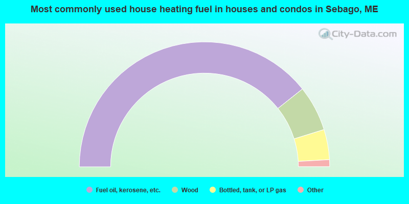
- 78.6%Fuel oil, kerosene, etc.
- 11.8%Wood
- 7.8%Bottled, tank, or LP gas
- 1.0%Utility gas
- 0.4%Solar energy
- 0.4%Other fuel
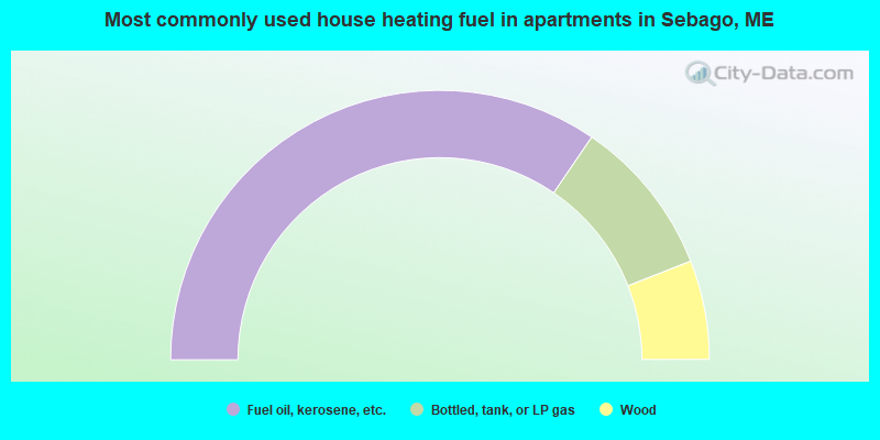
- 69.0%Fuel oil, kerosene, etc.
- 19.0%Bottled, tank, or LP gas
- 11.9%Wood
Sebago compared to Maine state average:
- Unemployed percentage significantly below state average.
- Black race population percentage significantly below state average.
- Hispanic race population percentage significantly below state average.
- Foreign-born population percentage below state average.
- Renting percentage below state average.
- Length of stay since moving in significantly above state average.
- Number of rooms per house significantly below state average.
- House age significantly below state average.

|
Total of 11 patent applications in 2008-2024.