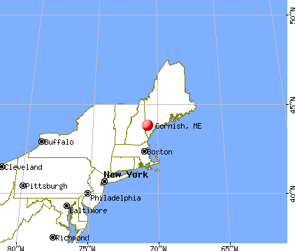
Cornish, Maine

Cornish: Early, Merrifield Farm

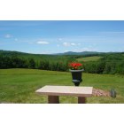
Cornish: View of the setting sun from the Baker Cemetery, Cornish, Maine

Cornish: View of the setting sun from Hessian Hill, Cornish, Maine.
Cornish: From the Hill looking north
- add
your
Submit your own pictures of this town and show them to the world
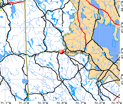
- OSM Map
- General Map
- Google Map
- MSN Map
Population change since 2000: +10.6%
 |
| Males: 711 | |
| Females: 692 |
| Median resident age: | 44.5 years |
| Maine median age: | 43.0 years |
Zip codes: 04020.
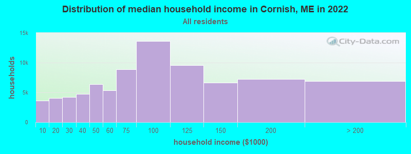
| Cornish: | $71,591 |
| ME: | $69,543 |
Estimated per capita income in 2022: $35,590 (it was $17,494 in 2000)
Cornish town income, earnings, and wages data
Estimated median house or condo value in 2022: $315,901 (it was $98,900 in 2000)
| Cornish: | $315,901 |
| ME: | $290,600 |
Mean prices in 2022: all housing units: $451,552; detached houses: $470,451; townhouses or other attached units: $577,335; in 2-unit structures: $383,179; in 3-to-4-unit structures: $310,696; in 5-or-more-unit structures: $252,113; mobile homes: $105,501
Detailed information about poverty and poor residents in Cornish, ME


- 1,37197.7%White alone
- 161.1%Hispanic
- 60.4%Black alone
- 40.3%American Indian alone
- 40.3%Two or more races
- 10.07%Asian alone
- 10.07%Other race alone
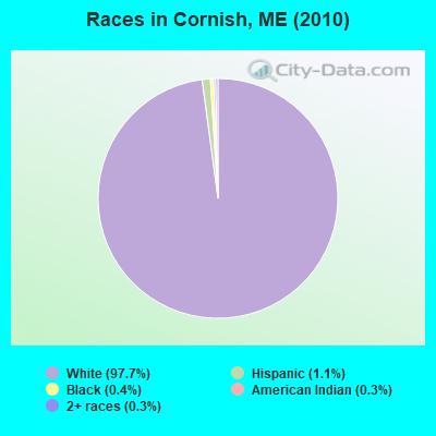
Races in Cornish detailed stats: ancestries, foreign born residents, place of birth
According to our research of Maine and other state lists, there were 4 registered sex offenders living in Cornish, Maine as of April 28, 2024.
The ratio of all residents to sex offenders in Cornish is 351 to 1.
 Recent articles from our blog. Our writers, many of them Ph.D. graduates or candidates, create easy-to-read articles on a wide variety of topics.

 | Maine weather thread (3207 replies) |
| Move to Maine??? every passing day you will find this to be true: (245 replies) |
| RT 25 from NH to Portland (4 replies) |
| Maybe a Relocation To Maine (28 replies) |
| West Falmouth?? (3 replies) |
| Potential move (hopefully) (18 replies) |
Latest news from Cornish, ME collected exclusively by city-data.com from local newspapers, TV, and radio stations
Ancestries: English (24.6%), United States (15.8%), French (9.1%), Irish (8.6%), Italian (6.4%), Scottish (6.3%).
Current Local Time: EST time zone
Incorporated on 02/27/1794
Elevation: 353 feet
Land area: 22.1 square miles.
Population density: 63 people per square mile (very low).
15 residents are foreign born
| This town: | 1.2% |
| Maine: | 2.9% |
| Cornish town: | 1.1% ($1,073) |
| Maine: | 1.5% ($1,417) |
Nearest city with pop. 50,000+: Portland, ME  (28.0 miles , pop. 64,249).
Nearest city with pop. 200,000+: Boston, MA (101.4 miles , pop. 589,141).
Nearest city with pop. 1,000,000+: Bronx, NY (256.0 miles , pop. 1,332,650).
Nearest cities:
), ), ), )Latitude: 43.77 N, Longitude: 70.81 W
Area code: 207

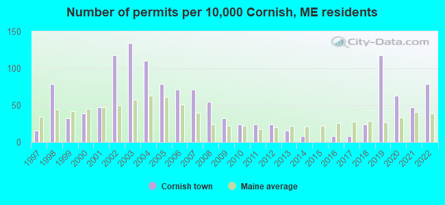
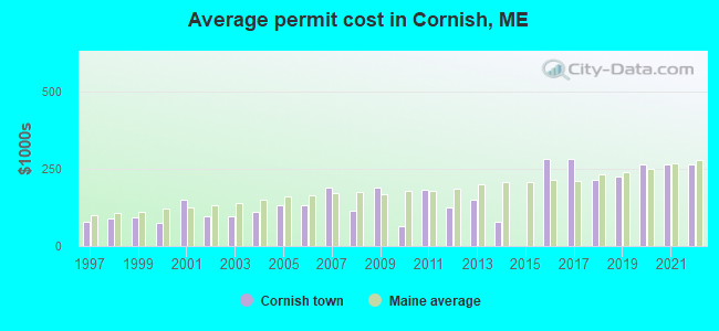
Single-family new house construction building permits:
- 2022: 10 buildings, average cost: $262,800
- 2021: 6 buildings, average cost: $262,500
- 2020: 8 buildings, average cost: $265,300
- 2019: 15 buildings, average cost: $224,300
- 2018: 3 buildings, average cost: $213,300
- 2017: 1 building, cost: $280,000
- 2016: 1 building, cost: $280,000
- 2014: 1 building, cost: $80,000
- 2013: 2 buildings, average cost: $150,000
- 2012: 3 buildings, average cost: $124,300
- 2011: 3 buildings, average cost: $183,300
- 2010: 3 buildings, average cost: $64,400
- 2009: 4 buildings, average cost: $190,300
- 2008: 7 buildings, average cost: $112,900
- 2007: 9 buildings, average cost: $189,400
- 2006: 9 buildings, average cost: $130,900
- 2005: 10 buildings, average cost: $129,500
- 2004: 14 buildings, average cost: $110,900
- 2003: 17 buildings, average cost: $96,300
- 2002: 15 buildings, average cost: $97,000
- 2001: 6 buildings, average cost: $149,500
- 2000: 5 buildings, average cost: $74,700
- 1999: 4 buildings, average cost: $94,300
- 1998: 10 buildings, average cost: $89,500
- 1997: 2 buildings, average cost: $80,000
| Here: | 3.6% |
| Maine: | 3.4% |
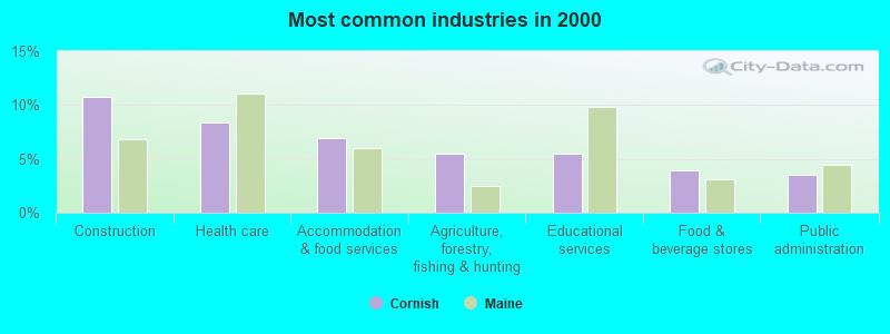
- Construction (10.7%)
- Health care (8.4%)
- Accommodation & food services (7.0%)
- Agriculture, forestry, fishing & hunting (5.5%)
- Educational services (5.5%)
- Food & beverage stores (3.9%)
- Public administration (3.5%)
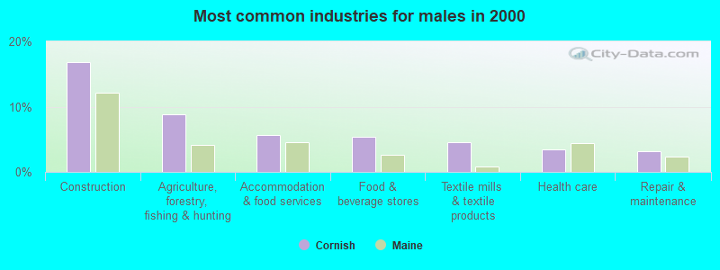
- Construction (16.8%)
- Agriculture, forestry, fishing & hunting (8.8%)
- Accommodation & food services (5.7%)
- Food & beverage stores (5.4%)
- Textile mills & textile products (4.6%)
- Health care (3.4%)
- Repair & maintenance (3.1%)

- Health care (14.5%)
- Educational services (9.9%)
- Accommodation & food services (8.5%)
- Professional, scientific, technical services (5.3%)
- Public administration (5.0%)
- Finance & insurance (4.3%)
- Social assistance (3.9%)
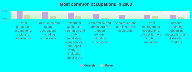
- Other production occupations, including supervisors (6.0%)
- Other sales and related occupations, including supervisors (5.4%)
- Electrical equipment mechanics and other installation, maintenance, and repair workers, including supervisors (4.7%)
- Other office and administrative support workers, including supervisors (3.8%)
- Secretaries and administrative assistants (3.5%)
- Other management occupations, except farmers and farm managers (3.3%)
- Material recording, scheduling, dispatching, and distributing workers (3.0%)
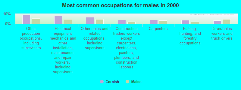
- Other production occupations, including supervisors (8.8%)
- Electrical equipment mechanics and other installation, maintenance, and repair workers, including supervisors (8.0%)
- Other sales and related occupations, including supervisors (6.6%)
- Construction traders workers except carpenters, electricians, painters, plumbers, and construction laborers (4.0%)
- Carpenters (4.0%)
- Fishing, hunting, and forestry occupations (3.7%)
- Driver/sales workers and truck drivers (3.4%)
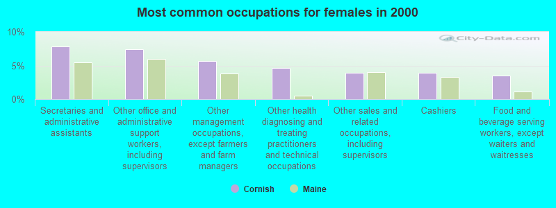
- Secretaries and administrative assistants (7.8%)
- Other office and administrative support workers, including supervisors (7.4%)
- Other management occupations, except farmers and farm managers (5.7%)
- Other health diagnosing and treating practitioners and technical occupations (4.6%)
- Other sales and related occupations, including supervisors (3.9%)
- Cashiers (3.9%)
- Food and beverage serving workers, except waiters and waitresses (3.5%)
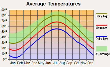
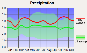
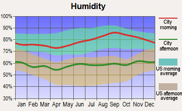
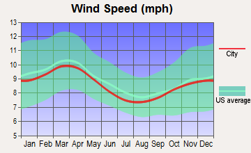
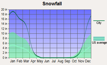
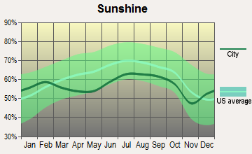
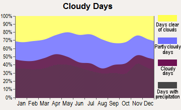
Average climate in Cornish, Maine
Based on data reported by over 4,000 weather stations
(lower is better)
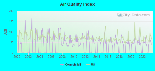
Air Quality Index (AQI) level in 2023 was 48.8. This is significantly better than average.
| City: | 48.8 |
| U.S.: | 72.6 |
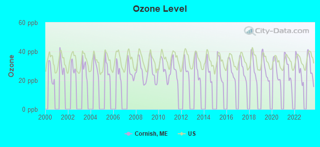
Ozone [ppb] level in 2023 was 29.7. This is about average. Closest monitor was 12.1 miles away from the city center.
| City: | 29.7 |
| U.S.: | 33.3 |
Tornado activity:
Cornish-area historical tornado activity is significantly above Maine state average. It is 72% smaller than the overall U.S. average.
On 7/18/1963, a category F2 (max. wind speeds 113-157 mph) tornado 23.0 miles away from the Cornish town center caused between $5000 and $50,000 in damages.
On 10/10/1966, a category F2 tornado 23.8 miles away from the town center caused between $5000 and $50,000 in damages.
Earthquake activity:
Cornish-area historical earthquake activity is significantly above Maine state average. It is 73% smaller than the overall U.S. average.On 10/16/2012 at 23:12:25, a magnitude 4.7 (4.7 ML, Depth: 10.0 mi, Class: Light, Intensity: IV - V) earthquake occurred 14.4 miles away from the city center
On 4/20/2002 at 10:50:47, a magnitude 5.3 (5.3 ML, Depth: 3.0 mi, Class: Moderate, Intensity: VI - VII) earthquake occurred 152.2 miles away from Cornish center
On 1/19/1982 at 00:14:42, a magnitude 4.7 (4.5 MB, 4.7 MD, 4.5 LG) earthquake occurred 43.9 miles away from Cornish center
On 4/20/2002 at 10:50:47, a magnitude 5.2 (5.2 MB, 4.2 MS, 5.2 MW, 5.0 MW) earthquake occurred 152.6 miles away from the city center
On 10/7/1983 at 10:18:46, a magnitude 5.3 (5.1 MB, 5.3 LG, 5.1 ML) earthquake occurred 176.6 miles away from the city center
On 8/21/1996 at 07:54:14, a magnitude 3.8 (3.8 LG, 3.6 LG, Depth: 6.2 mi, Class: Light, Intensity: II - III) earthquake occurred 39.2 miles away from the city center
Magnitude types: regional Lg-wave magnitude (LG), body-wave magnitude (MB), duration magnitude (MD), local magnitude (ML), surface-wave magnitude (MS), moment magnitude (MW)
Natural disasters:
The number of natural disasters in York County (31) is a lot greater than the US average (15).Major Disasters (Presidential) Declared: 23
Emergencies Declared: 8
Causes of natural disasters: Floods: 21, Storms: 16, Winter Storms: 6, Snows: 5, Winds: 3, Heavy Rains: 2, Hurricanes: 2, Blizzard: 1, Ice Storm: 1, Mudslide: 1, Snowfall: 1, Snowstorm: 1, Tornado: 1, Tropical Storm: 1 (Note: some incidents may be assigned to more than one category).
Colleges/universities with over 2000 students nearest to Cornish:
- Saint Joseph's College of Maine (about 17 miles; Standish, ME; Full-time enrollment: 2,010)
- University of Southern Maine (about 28 miles; Portland, ME; FT enrollment: 6,647)
- Southern Maine Community College (about 31 miles; South Portland, ME; FT enrollment: 4,666)
- University of New England (about 31 miles; Biddeford, ME; FT enrollment: 4,539)
- Plymouth State University (about 45 miles; Plymouth, NH; FT enrollment: 4,838)
- University of New Hampshire-Main Campus (about 45 miles; Durham, NH; FT enrollment: 15,243)
- NHTI-Concord's Community College (about 53 miles; Concord, NH; FT enrollment: 2,865)
Private elementary/middle school in Cornish:
Points of interest:
Notable locations in Cornish: Bonney Memorial Library (A), Cornish Volunteer Fire Department (B), Odd Fellows-Rebekah Hall (C). Display/hide their locations on the map
Cemeteries: Merrill Cemetery (1), Barker Cemetery (2), Ricker Cemetery (3), Day Cemetery (4), Riverside Cemetery (5), Pendexter Cemetery (6), Guptill Cemetery (7). Display/hide their locations on the map
Lake: Haley Ponds (A). Display/hide its location on the map
Streams, rivers, and creeks: Little River (A), Merrifield Brook (B), Pugsley Brook (C). Display/hide their locations on the map
Hotel: Mid-Way Motel (South Hiram Rd) (1). Display/hide its approximate location on the map
Birthplace of: David Dunn (Maine) - Governor of Maine.
Drinking water stations with addresses in Cornish and their reported violations in the past:
OSSIPEE VALLEY CHRISTIAN SCHOOL (Population served: 75, Groundwater):Past health violations:Past monitoring violations:
- Treatment Technique (SWTR and GWR) - In OCT-2010, Contaminant: GROUNDWATER RULE. Follow-up actions: St Compliance achieved (SEP-07-2011)
- MCL, Monthly (TCR) - In OCT-2010, Contaminant: Coliform. Follow-up actions: St Public Notif requested (NOV-12-2010), St Formal NOV issued (NOV-12-2010), St Public Notif received (DEC-01-2010), St Compliance achieved (MAR-03-2011)
- MCL, Monthly (TCR) - In NOV-2005, Contaminant: Coliform. Follow-up actions: St Public Notif requested (DEC-01-2005), St Violation/Reminder Notice (DEC-01-2005), St Compliance achieved (MAR-12-2008), St Intentional no-action (AUG-24-2011)
- MCL, Acute (TCR) - In OCT-2005, Contaminant: Coliform. Follow-up actions: St Tech Assistance Visit (OCT-26-2005), St Violation/Reminder Notice (OCT-26-2005), St Public Notif requested (OCT-26-2005), St Boil Water Order (OCT-26-2005), St Public Notif received (2 times from NOV-10-2005 to NOV-10-2005), St Compliance achieved (MAR-12-2008)
- Follow-up Or Routine LCR Tap M/R - In OCT-01-2011, Contaminant: Lead and Copper Rule. Follow-up actions: St Public Notif requested (DEC-09-2011), St Formal NOV issued (DEC-09-2011), St Public Notif received (FEB-23-2012), St Compliance achieved (AUG-20-2012)
- Follow-up Or Routine LCR Tap M/R - In OCT-01-2010, Contaminant: Lead and Copper Rule. Follow-up actions: St Formal NOV issued (DEC-29-2010), St Public Notif requested (DEC-29-2010), St Public Notif received (MAY-01-2012), St Compliance achieved (AUG-20-2012)
- Water Quality Parameter M/R - Between OCT-2009 and DEC-2009, Contaminant: Lead and Copper Rule. Follow-up actions: St Public Notif requested (MAY-05-2010), St Formal NOV issued (MAY-05-2010), St Public Notif received (JUN-28-2010), St Compliance achieved (JUL-18-2011), St Public Notif received (MAY-01-2012)
- Water Quality Parameter M/R - Between JUL-2009 and SEP-2009, Contaminant: Lead and Copper Rule. Follow-up actions: St Public Notif requested (MAY-05-2010), St Formal NOV issued (MAY-05-2010), St Public Notif received (MAY-01-2012)
- Water Quality Parameter M/R - Between JAN-2009 and MAR-2009, Contaminant: Lead and Copper Rule. Follow-up actions: St Public Notif requested (MAY-05-2010), St Formal NOV issued (MAY-05-2010), St Public Notif received (MAY-01-2012)
- 14 routine major monitoring violations
- 63 regular monitoring violations
- One other older monitoring violation
Drinking water stations with addresses in Cornish that have no violations reported:
- CORNISH WATER DISTRICT (Population served: 708, Primary Water Source Type: Groundwater)
| This town: | 2.3 people |
| Maine: | 2.3 people |
| This town: | 66.5% |
| Whole state: | 62.9% |
| This town: | 7.9% |
| Whole state: | 9.4% |
Likely homosexual households (counted as self-reported same-sex unmarried-partner households)
- Lesbian couples: 0.2% of all households
- Gay men: 0.5% of all households
| This town: | 13.7% |
| Whole state: | 10.9% |
| This town: | 4.4% |
| Whole state: | 4.1% |
4 people in homes for the mentally retarded in 2000
Banks with branches in Cornish (2011 data):
- Bangor Savings Bank: Cornish Branch at 180 Maple Street, branch established on 1910/08/08. Info updated 2008/12/02: Bank assets: $2,556.3 mil, Deposits: $1,940.3 mil, headquarters in Bangor, ME, positive income, Commercial Lending Specialization, 58 total offices, Holding Company: Bangor Bancorp, Mhc
For population 15 years and over in Cornish:
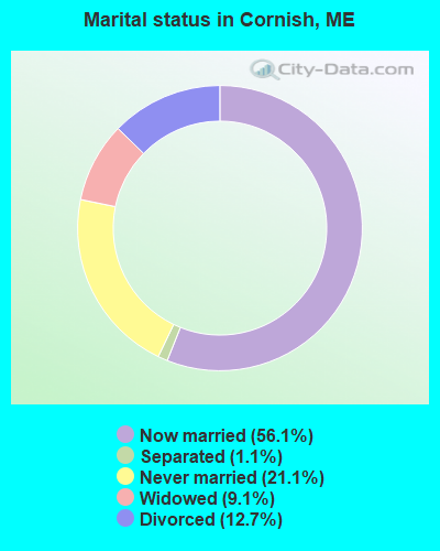
- Never married: 21.1%
- Now married: 56.1%
- Separated: 1.1%
- Widowed: 9.1%
- Divorced: 12.7%
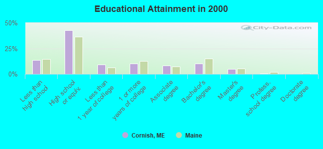
For population 25 years and over in Cornish:
- High school or higher: 86.2%
- Bachelor's degree or higher: 15.9%
- Graduate or professional degree: 5.7%
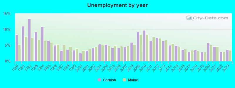
- Unemployed: 1.9%
- Mean travel time to work (commute): 34.2 minutes
| Here: | 9.8 |
| Maine average: | 11.2 |


Graphs represent county-level data. Detailed 2008 Election Results
Religion statistics for Cornish, ME (based on York County data)
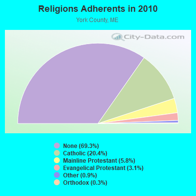

| Religion | Adherents | Congregations |
|---|---|---|
| Catholic | 40,283 | 16 |
| Mainline Protestant | 11,480 | 64 |
| Evangelical Protestant | 6,086 | 51 |
| Other | 1,847 | 18 |
| Orthodox | 625 | 3 |
| Black Protestant | 119 | 1 |
| None | 136,691 | - |
Food Environment Statistics:
| Here: | 2.24 / 10,000 pop. |
| Maine: | 2.80 / 10,000 pop. |
| This county: | 0.05 / 10,000 pop. |
| Maine: | 0.14 / 10,000 pop. |
| This county: | 2.09 / 10,000 pop. |
| Maine: | 2.20 / 10,000 pop. |
| This county: | 4.23 / 10,000 pop. |
| Maine: | 5.75 / 10,000 pop. |
| York County: | 12.53 / 10,000 pop. |
| Maine: | 11.02 / 10,000 pop. |
| Here: | 7.7% |
| Maine: | 8.2% |
| Here: | 24.0% |
| Maine: | 25.0% |
| Businesses in Cornish, ME | ||||
| Name | Count | Name | Count | |
|---|---|---|---|---|
| Dunkin Donuts | 1 | Subway | 1 | |
| GNC | 1 | True Value | 1 | |
| MasterBrand Cabinets | 2 | U-Haul | 1 | |
| Rite Aid | 1 | |||
Strongest AM radio stations in Cornish:
- WMTW (870 AM; 10 kW; GORHAM, ME; Owner: RADIO PARTNERS OF MAINE, L.P.)
- WGAN (560 AM; 5 kW; PORTLAND, ME; Owner: SAGA COMMUNICATIONS OF NEW ENGLAND, LLC)
- WGIN (930 AM; 10 kW; ROCHESTER, NH; Owner: CAPSTAR TX LIMITED PARTNERSHIP)
- WRKO (680 AM; 50 kW; BOSTON, MA; Owner: ENTERCOM BOSTON LICENSE, LLC)
- WJAE (1440 AM; 5 kW; WESTBROOK, ME; Owner: ALTANTIC COAST RADIO, LLC)
- WZAN (970 AM; 5 kW; PORTLAND, ME; Owner: SAGA COMMUNICATIONS OF NEW ENGLAND, LLC)
- WLOB (1310 AM; 5 kW; PORTLAND, ME; Owner: ATLANTIC COAST RADIO, LLC)
- WASR (1420 AM; 5 kW; WOLFEBORO, NH; Owner: RADIO WOLFEBORO, INC.)
- WEEI (850 AM; 50 kW; BOSTON, MA; Owner: ENTERCOM BOSTON LICENSE, LLC)
- WBZ (1030 AM; 50 kW; BOSTON, MA; Owner: INFINITY BROADCASTING OPERATIONS, INC.)
- WTME (780 AM; 10 kW; RUMFORD, ME; Owner: MOUNTAIN VALLEY BROADCASTING, INC.)
- WCRN (830 AM; 50 kW; WORCESTER, MA; Owner: CARTER BROADCASTING CORPORATION)
- WKOX (1200 AM; 50 kW; FRAMINGHAM, MA; Owner: CAPSTAR TX LIMITED PARTNERSHIP)
Strongest FM radio stations in Cornish:
- WMEA (90.1 FM; PORTLAND, ME; Owner: MAINE PUBLIC BROADCASTING CORPORATION)
- WSCY (106.9 FM; MOULTONBOROUGH, NH; Owner: NORTHEAST COMMUNICATIONS CORPORATION)
- WBLM (102.9 FM; PORTLAND, ME; Owner: CITADEL BROADCASTING COMPANY)
- WPKQ (103.7 FM; NORTH CONWAY, NH; Owner: CITADEL BROADCASTING COMPANY)
- WHOM (94.9 FM; MT. WASHINGTON, NH; Owner: CITADEL BROADCASTING COMPANY)
- WVFM (105.7 FM; CAMPTON, NH; Owner: DEVON BROADCASTING COMPANY, INC.)
- WJBQ (97.9 FM; PORTLAND, ME; Owner: CITADEL BROADCASTING COMPANY)
- WTHT (107.5 FM; LEWISTON, ME; Owner: RADIO PARTNERS OF MAINE, L.P.)
- WLKZ (104.9 FM; WOLFEBORO, NH; Owner: TELE-MEDIA COMPANY OF NEW HAMPSHIRE, L.L.C.)
- WPHX-FM (92.1 FM; SANFORD, ME; Owner: FNX BROADCASTING LLC)
- WSEW (88.5 FM; SANFORD, ME; Owner: WORD RADIO EDUCATIONAL FOUNDATION)
- WMTW-FM (106.7 FM; NORTH WINDHAM, ME; Owner: RADIO PARTNERS OF MAINE, L.P.)
- WPOR (101.9 FM; PORTLAND, ME; Owner: SAGA COMMUNICATIONS OF NEW ENGLAND, LLC)
- WVMJ (104.5 FM; CONWAY, NH; Owner: MT. WASHINGTON RADIO & GRAMOPHONE, L.L.C.)
- WMEX (106.5 FM; FARMINGTON, NH; Owner: WIMMEX, LLC)
- WMWV (93.5 FM; CONWAY, NH; Owner: MT. WASHINGTON RADIO & GRAMOPHONE, L.L.C.)
- WMEK-FM (99.9 FM; AUBURN, ME; Owner: RADIO PARTNERS OF MAINE, L.P.)
- WMSJ (89.3 FM; FREEPORT, ME; Owner: DOWNEAST CHRISTIAN COMMUNICATIONS)
- WPNH-FM (100.1 FM; PLYMOUTH, NH; Owner: NORTHEAST COMMUNICATIONS CORPORATION)
- WCYY (94.3 FM; BIDDEFORD, ME; Owner: CITADEL BROADCASTING COMPANY)
TV broadcast stations around Cornish:
- WMTW-TV (Channel 8; POLAND SPRING, ME; Owner: WMTW BROADCAST GROUP, LLC)
- WCSH (Channel 6; PORTLAND, ME; Owner: PACIFIC AND SOUTHERN COMPANY, INC.)
- WGME-TV (Channel 13; PORTLAND, ME; Owner: WGME LICENSEE, LLC)
- WMEA-TV (Channel 26; BIDDEFORD, ME; Owner: MAINE PUBLIC BROADCASTING CORP.)
- WPXT (Channel 51; PORTLAND, ME; Owner: HMW, INC.)
- WPME (Channel 35; LEWISTON, ME; Owner: KB PRIME MEDIA LLC)
- W32CA (Channel 32; PORTLAND, ME; Owner: NATIONAL MINORITY T.V., INC.)
- Cornish, Maine
- Fatal accident count13
- Vehicles involved in fatal accidents16
- Fatal accidents involving drunk persons:3
- Fatalities13
- Persons involved in fatal accidents27
- Pedestrians involved in fatal accidents0
- Maine average
- Fatal accident count2185
- Vehicles involved in fatal accidents3156
- Fatal accidents involving drunk persons866
- Fatalities2385
- Persons involved in fatal accidents5261
- Pedestrians involved in fatal accidents127
- National Bridge Inventory (NBI) Statistics
- 5Number of bridges
- 59ft / 17.6mTotal length
- 10,068Total average daily traffic
- 501Total average daily truck traffic
- 14,303Total future (year 2036) average daily traffic
FCC Registered Cell Phone Towers:
1- 200 Sawyer Rd (Lat: 43.751861 Lon: -70.780194), Type: Ltower, Structure height: 45.7 m, Call Sign: KNKA452
Assigned Frequencies: 869.040 MHz, 869.040 MHz, 869.040 MHz, 824.040 MHz, 824.040 MHz, 824.040 MHz, 890.010 MHz, 890.010 MHz, 890.010 MHz, 845.010 MHz, 845.010 MHz, 845.010 MHzGrant Date: 08/29/2017, Expiration Date: 10/01/2027, Certifier: Michael P GogginRegistrant: At&t Services, Inc., 208 S Akard St, 20f, Dallas, TX 75202, Phone: (855) 699-7073, Fax: (214) 746-6410, Email:
FCC Registered Antenna Towers:
5- Paul M Alberghini, Off Route 25 - Small Hill (Lat: 43.837222 Lon: -70.819167), Type: 86.3, Overall height: 76.2 m, Registrant: Kah Communication, LLC, Wrlscon@maine.Rr.Com, , Cumbe-rland, Phone: (207) 829-4512
- Brian J Hargraves, Off Route 25 - Small Hill (Lat: 43.837222 Lon: -70.819167), Type: 86.3, Overall height: 76.2 m, Registrant: American Tower Corporation, Bhargraves@americantower.Com, , Bosto-n, Phone: (617) 585-7617
- Sean O'Malley, Off Route 25 - Small Hill (Lat: 43.837222 Lon: -70.819167), Type: 86.3, Overall height: 76.2 m, Registrant: Faa/Fcc Compliance Specialist, Bosto-n, Phone: (617) 585-7600
- Shelley Doolity, Off Route 25 - Small Hill (Lat: 43.837222 Lon: -70.819167), Type: 86.3, Overall height: 76.2 m, Registrant: 8784 Portl-and, Phone: (207) 797-7536
- Off Route 25 - Small Hill (Lat: 43.837222 Lon: -70.819167), Type: 86.3, Overall height: 76.2 m, Registrant: At&t Corp, Pcheeks@att.Com, , Atlan-ta, Phone: (404) 810-4021
FCC Registered Broadcast Land Mobile Towers:
6- Rt 5 2 Mi S (Lat: 43.753417 Lon: -70.827833), Call Sign: KCC575,
Assigned Frequencies: 47.2200 MHz, 47.2600 MHz, 47.3400 MHz, Grant Date: 05/28/2014, Expiration Date: 07/14/2024, Registrant: State Of Maine, O.I.T., Radio Operations, 66 Industrial Drive, Augusta, ME 04333-0147, Phone: (207) 624-9990, Email:
- Day Hill Off Rt 5 (Lat: 43.753417 Lon: -70.827833), Call Sign: WNLV736,
Assigned Frequencies: 457.400 MHz, Grant Date: 04/28/2023, Expiration Date: 06/29/2033, Registrant: State Of Maine, O.I.T., Radio Operations, 66 Industrial Drive, Augusta, ME 04333-0147, Phone: (207) 624-9990, Email:
- HOSAC, Clark Mnt (Lat: 43.750972 Lon: -70.781417), Type: Tower, Structure height: 45.7 m, Call Sign: WQPS394,
Assigned Frequencies: 157.515 MHz, Grant Date: 05/25/2022, Expiration Date: 08/02/2032, Certifier: Marc D Fisher, Registrant: State Of Maine, O.I.T., Radio Operations, 66 Industrial Drive, Augusta, ME 04333-0147, Phone: (207) 624-9990, Email:
- HOSAC MTN, Lat: 43.750972 Lon: -70.781417, Call Sign: WQPW280,
Assigned Frequencies: 159.300 MHz, Grant Date: 07/16/2022, Expiration Date: 08/28/2032, Certifier: David J Plourde, Registrant: State Of Maine, O.I.T., Radio Operations, 66 Industrial Drive, Augusta, ME 04333-0147, Phone: (207) 624-9990, Email:
- HOSAC, Lat: 43.750972 Lon: -70.781417, Call Sign: WQQI358,
Assigned Frequencies: 159.165 MHz, Grant Date: 10/07/2022, Expiration Date: 12/20/2032, Certifier: Marc D Fisher, Registrant: State Of Maine, O.I.T., Radio Operations, 66 Industrial Drive, Augusta, ME 04333-0147, Phone: (207) 624-9990, Email:
- Hosac Mountain (Lat: 43.751111 Lon: -70.781389), Type: Ltower, Structure height: 45.7 m, Call Sign: WQSC866,
Assigned Frequencies: 169.887 MHz, Grant Date: 06/28/2023, Expiration Date: 09/03/2033, Certifier: Marc D Fisher, Registrant: State Of Maine, O.I.T., Radio Operations, 66 Industrial Drive, Augusta, ME 04333-0147, Phone: (207) 624-9990, Email:
FCC Registered Microwave Towers:
3- HOSAC MTN, Hosac Mountain (Lat: 43.750972 Lon: -70.781417), Type: Ltower, Structure height: 45.7 m, Call Sign: WQOZ335,
Assigned Frequencies: 934.375 MHz, 6655.00 MHz, 6655.00 MHz, 6655.00 MHz, 6655.00 MHz, 6655.00 MHz, 6655.00 MHz, 6655.00 MHz, 6655.00 MHz, Grant Date: 12/21/2021, Expiration Date: 03/12/2032, Certifier: David J Plourde, Registrant: State Of Maine, O.I.T., Radio Operations, 66 Industrial Drive, Augusta, ME 04333-0147, Phone: (207) 624-9990, Email:
- CORNISH SWYR, 200 Sawyer Road (Lat: 43.751861 Lon: -70.780194), Type: Ltower, Structure height: 45.7 m, Call Sign: WQUG402,
Assigned Frequencies: 10815.0 MHz, 10735.0 MHz, 10775.0 MHz, 10815.0 MHz, 10855.0 MHz, Grant Date: 06/30/2014, Expiration Date: 06/30/2024, Certifier: John E Monday, Registrant: At&t Services, Inc., 208 S Akard St, 20f, Dallas, TX 75202, Phone: (855) 699-7073, Email:
- CORNISH, 2.5 Mi Nw Of (Lat: 43.837278 Lon: -70.819222), Overall height: 86.3 m, Call Sign: KCK61,
Assigned Frequencies: 3710.00 MHz, 3730.00 MHz, 3890.00 MHz, 3790.00 MHz, 3810.00 MHz, 3970.00 MHz, 3870.00 MHz, 3890.00 MHz, 4050.00 MHz, 3950.00 MHz... (+6 more), Grant Date: 11/29/1989, Expiration Date: 01/27/1998, Cancellation Date: 01/27/1998, Registrant: At&t Communications Of The Virgin Islands Inc, 1200 Peachtree St Ne Floc 15w27, Atlanta, GA 30309
FCC Registered Amateur Radio Licenses:
6- Call Sign: K1BKJ, Licensee ID: L00364421, Grant Date: 03/11/2008, Expiration Date: 03/18/2018, Cancellation Date: 03/19/2020, Certifier: Donald W Morton, Registrant: Donald W Morton, 28 Maple St, Cornish, ME 04020
- Call Sign: KA7HPG, Licensee ID: L00366345, Grant Date: 12/09/2014, Expiration Date: 12/13/2024, Certifier: Daniel R Haig, Registrant: Daniel R Haig, 1889 North Road, Cornish, ME 04020-3801
- Call Sign: N1SDJ, Licensee ID: L00884079, Grant Date: 05/22/2014, Expiration Date: 07/06/2024, Certifier: Karl R Roney, Registrant: Karl R Roney, 264 High Road, Cornish, ME 04020
- Call Sign: N1SNR, Licensee ID: L00900328, Grant Date: 06/06/2014, Expiration Date: 08/03/2024, Certifier: Jeffrey A Hartford, Registrant: Jeffrey A Hartford, 32 Maple St, Cornish, ME 04020
- Call Sign: N1TGT, Licensee ID: L00900340, Grant Date: 08/26/2014, Expiration Date: 10/18/2024, Registrant: Deanna L Hartford, 32 Maple St., Cornish, ME 04020
- Call Sign: N4GLF, Previous Call Sign: KG4HQO, Licensee ID: L00237632, Grant Date: 05/19/2015, Expiration Date: 05/19/2025, Certifier: Gerald L Ford, Registrant: Gerald L Ford, 1167 Sokokis Trail, Cornish, ME 04020
FAA Registered Aircraft:
1- Aircraft: CESSNA 320B (Category: Land, Engines: 2, Seats: 6, Weight: Up to 12,499 Pounds, Speed: 183 mph), Engine: Reciprocating
N-Number: 103DT, N103DT, N-103DT, Serial Number: 320B0004, Certificate Issue Date: 12/02/2010
Registrant (Co-Owned): Stephen I Prescott, 347 Main St, Cornish, ME 04020, Other Owners: Faye M Prescott
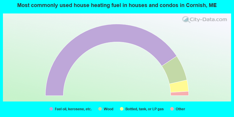
- 81.4%Fuel oil, kerosene, etc.
- 11.6%Wood
- 5.1%Bottled, tank, or LP gas
- 1.4%Electricity
- 0.5%Other fuel
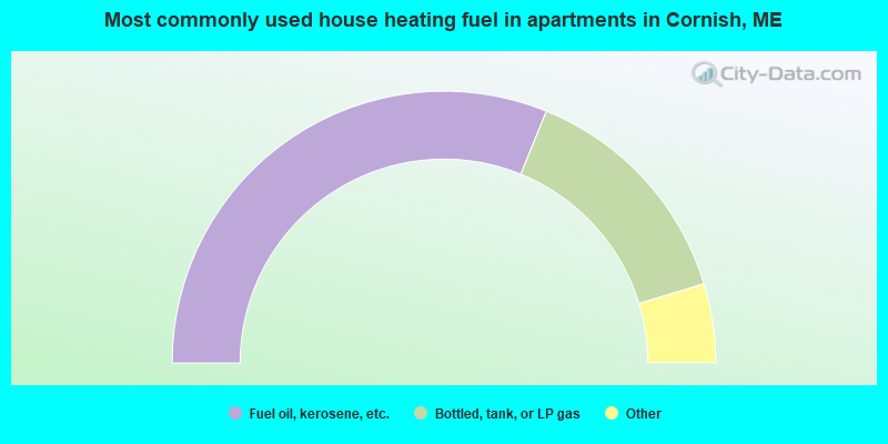
- 62.3%Fuel oil, kerosene, etc.
- 28.3%Bottled, tank, or LP gas
- 3.8%Utility gas
- 3.8%Wood
- 1.9%Electricity
Cornish compared to Maine state average:
- Unemployed percentage significantly below state average.
- Black race population percentage significantly below state average.
- Foreign-born population percentage significantly below state average.
- Length of stay since moving in significantly above state average.
- Number of rooms per house significantly below state average.
- House age significantly below state average.
- Number of college students below state average.
- Percentage of population with a bachelor's degree or higher below state average.

|
Total of 2 patent applications in 2008-2024.