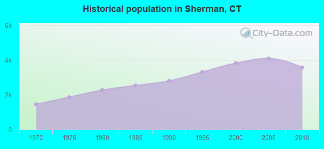
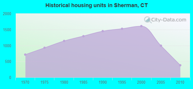
Sherman, Connecticut

Sherman: Happy Acres Farms in Sherman, Ct

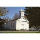
Sherman: Sherman Congregational Church
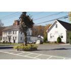
Sherman: Northurp House (1829) and Former Town Hall
Sherman: Library
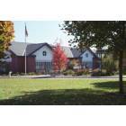
Sherman: Sherman Elementary School
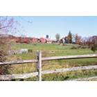
Sherman: Happy Acres Farm
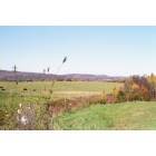
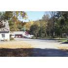
Sherman: Scenic Views

Sherman: Town Beach on Candlewood Lake
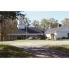
Sherman: Town Hall
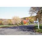
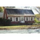
Sherman: Rural Neighborhood
Sherman: Playhouse in 1837 Church Building
Sherman: Town Center (Town Green)
- add
your
Submit your own pictures of this town and show them to the world
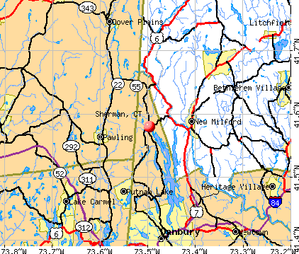
- OSM Map
- General Map
- Google Map
- MSN Map
Population change since 2000: -6.4%
 |
| Males: 1,794 | |
| Females: 1,787 |
| Median resident age: | 47.4 years |
| Connecticut median age: | 39.2 years |
Zip codes: 06784.
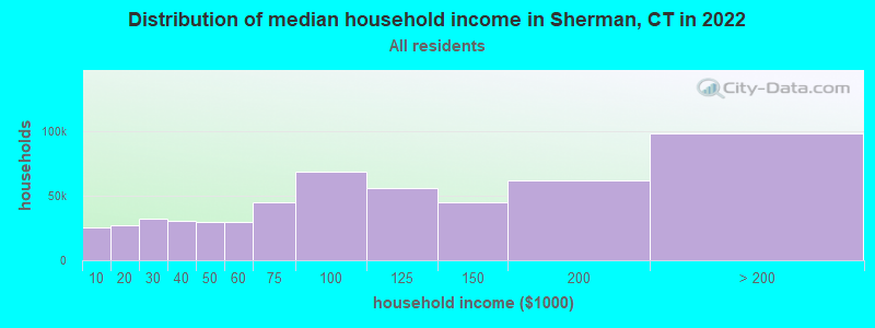
| Sherman: | $124,937 |
| CT: | $88,429 |
Estimated per capita income in 2022: $70,057 (it was $39,070 in 2000)
Sherman town income, earnings, and wages data
Estimated median house or condo value in 2022: $581,333 (it was $268,900 in 2000)
| Sherman: | $581,333 |
| CT: | $347,200 |
Mean prices in 2022: all housing units: $773,995; detached houses: $872,764; townhouses or other attached units: $449,164; in 2-unit structures: $329,188; in 3-to-4-unit structures: $346,815; in 5-or-more-unit structures: $346,835; mobile homes: $65,227
Detailed information about poverty and poor residents in Sherman, CT


- 3,41595.4%White alone
- 762.1%Hispanic
- 421.2%Two or more races
- 330.9%Asian alone
- 120.3%Black alone
- 20.06%Other race alone
- 10.03%American Indian alone
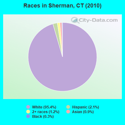
Races in Sherman detailed stats: ancestries, foreign born residents, place of birth
According to our research of Connecticut and other state lists, there were 4 registered sex offenders living in Sherman, Connecticut as of April 27, 2024.
The ratio of all residents to sex offenders in Sherman is 895 to 1.
The ratio of registered sex offenders to all residents in this city is near the state average.
 Recent articles from our blog. Our writers, many of them Ph.D. graduates or candidates, create easy-to-read articles on a wide variety of topics.

Latest news from Sherman, CT collected exclusively by city-data.com from local newspapers, TV, and radio stations
Sherman, CT City Guides:
Ancestries: Irish (23.6%), German (21.0%), Italian (18.2%), English (11.2%), United States (5.3%), Polish (4.8%).
Current Local Time: EST time zone
Incorporated on 10/1802
Elevation: 475 feet
Land area: 21.8 square miles.
Population density: 164 people per square mile (very low).
294 residents are foreign born (6.1% Europe, 0.9% Latin America).
| This town: | 7.7% |
| Connecticut: | 10.9% |
| Sherman town: | 1.0% ($2,719) |
| Connecticut: | 1.8% ($2,961) |
Nearest city with pop. 50,000+: Danbury, CT  (11.9 miles , pop. 74,848).
Nearest city with pop. 200,000+: Bronx, NY (53.9 miles , pop. 1,332,650).
Nearest cities:
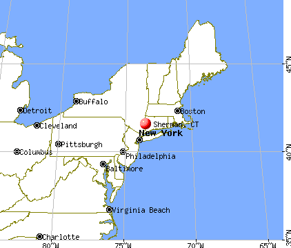
), ), ), Latitude: 41.57 N, Longitude: 73.50 W

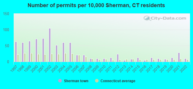
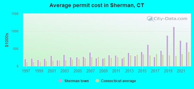
Single-family new house construction building permits:
- 2022: 4 buildings, average cost: $687,600
- 2021: 11 buildings, average cost: $737,700
- 2020: 5 buildings, average cost: $1,123,800
- 2019: 3 buildings, average cost: $877,500
- 2018: 4 buildings, average cost: $446,900
- 2017: 5 buildings, average cost: $269,400
- 2016: 2 buildings, average cost: $616,800
- 2015: 5 buildings, average cost: $414,100
- 2014: 3 buildings, average cost: $297,300
- 2013: 2 buildings, average cost: $392,500
- 2012: 9 buildings, average cost: $231,500
- 2011: 5 buildings, average cost: $312,300
- 2010: 4 buildings, average cost: $318,800
- 2009: 4 buildings, average cost: $227,000
- 2008: 4 buildings, average cost: $241,200
- 2007: 8 buildings, average cost: $399,600
- 2006: 8 buildings, average cost: $276,100
- 2005: 23 buildings, average cost: $263,000
- 2004: 23 buildings, average cost: $263,000
- 2003: 20 buildings, average cost: $328,000
- 2002: 40 buildings, average cost: $179,000
- 2001: 28 buildings, average cost: $307,400
- 2000: 27 buildings, average cost: $223,200
- 1999: 25 buildings, average cost: $184,600
- 1998: 23 buildings, average cost: $229,400
- 1997: 24 buildings, average cost: $213,600
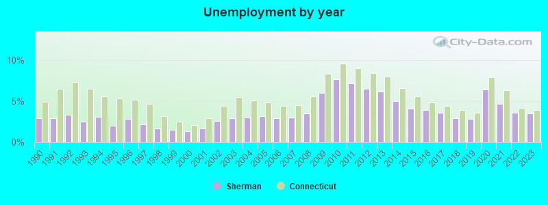
| Here: | 3.5% |
| Connecticut: | 3.9% |
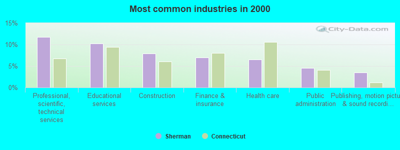
- Professional, scientific, technical services (11.7%)
- Educational services (10.3%)
- Construction (7.9%)
- Finance & insurance (7.0%)
- Health care (6.6%)
- Public administration (4.5%)
- Publishing, motion picture & sound recording industries (3.5%)
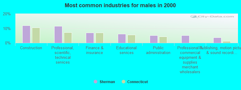
- Construction (11.9%)
- Professional, scientific, technical services (11.5%)
- Finance & insurance (7.0%)
- Educational services (6.1%)
- Public administration (5.1%)
- Professional & commercial equipment & supplies merchant wholesalers (5.1%)
- Publishing, motion picture & sound recording industries (3.7%)
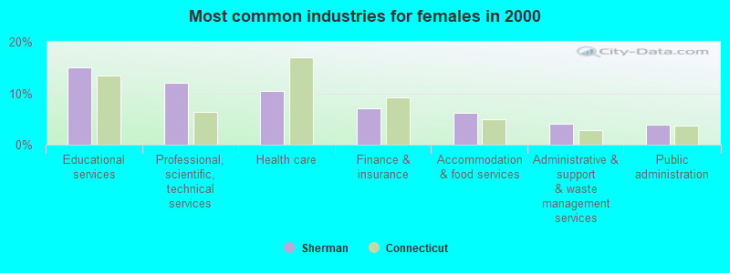
- Educational services (15.1%)
- Professional, scientific, technical services (12.0%)
- Health care (10.5%)
- Finance & insurance (7.0%)
- Accommodation & food services (6.2%)
- Administrative & support & waste management services (4.1%)
- Public administration (3.8%)
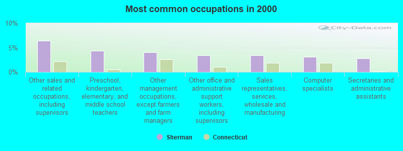
- Other sales and related occupations, including supervisors (6.4%)
- Preschool, kindergarten, elementary, and middle school teachers (4.4%)
- Other management occupations, except farmers and farm managers (4.1%)
- Other office and administrative support workers, including supervisors (3.4%)
- Sales representatives, services, wholesale and manufacturing (3.4%)
- Computer specialists (3.1%)
- Secretaries and administrative assistants (2.8%)
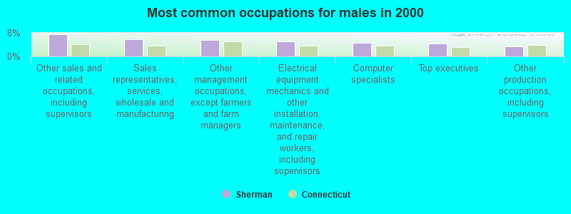
- Other sales and related occupations, including supervisors (7.6%)
- Sales representatives, services, wholesale and manufacturing (5.9%)
- Other management occupations, except farmers and farm managers (5.6%)
- Electrical equipment mechanics and other installation, maintenance, and repair workers, including supervisors (5.1%)
- Computer specialists (4.5%)
- Top executives (4.4%)
- Other production occupations, including supervisors (3.5%)
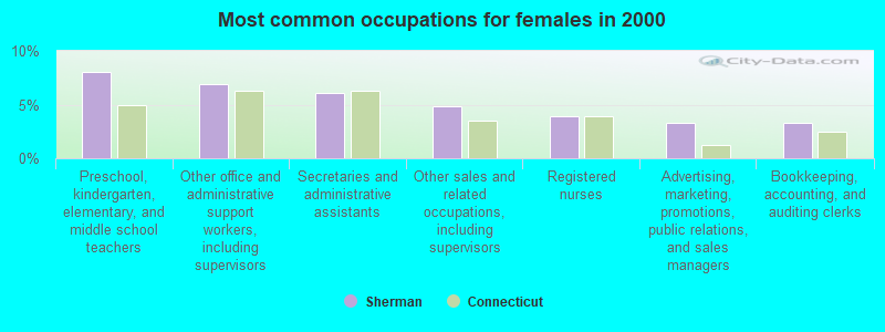
- Preschool, kindergarten, elementary, and middle school teachers (8.0%)
- Other office and administrative support workers, including supervisors (6.9%)
- Secretaries and administrative assistants (6.1%)
- Other sales and related occupations, including supervisors (4.9%)
- Registered nurses (4.0%)
- Advertising, marketing, promotions, public relations, and sales managers (3.3%)
- Bookkeeping, accounting, and auditing clerks (3.3%)
Average climate in Sherman, Connecticut
Based on data reported by over 4,000 weather stations


(lower is better)
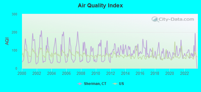
Air Quality Index (AQI) level in 2023 was 92.8. This is worse than average.
| City: | 92.8 |
| U.S.: | 72.6 |
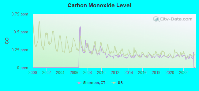
Carbon Monoxide (CO) [ppm] level in 2022 was 0.149. This is significantly better than average. Closest monitor was 20.1 miles away from the city center.
| City: | 0.149 |
| U.S.: | 0.251 |
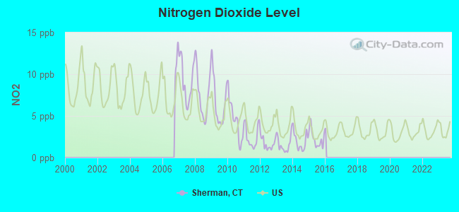
Nitrogen Dioxide (NO2) [ppb] level in 2015 was 2.27. This is significantly better than average. Closest monitor was 11.1 miles away from the city center.
| City: | 2.27 |
| U.S.: | 5.11 |
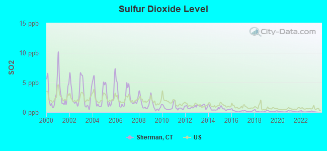
Sulfur Dioxide (SO2) [ppb] level in 2022 was 0.109. This is significantly better than average. Closest monitor was 11.1 miles away from the city center.
| City: | 0.109 |
| U.S.: | 1.515 |
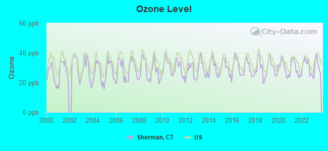
Ozone [ppb] level in 2023 was 30.7. This is about average. Closest monitor was 12.3 miles away from the city center.
| City: | 30.7 |
| U.S.: | 33.3 |
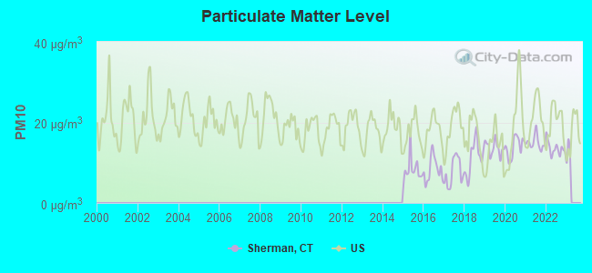
Particulate Matter (PM10) [µg/m3] level in 2022 was 13.6. This is significantly better than average. Closest monitor was 12.3 miles away from the city center.
| City: | 13.6 |
| U.S.: | 19.2 |
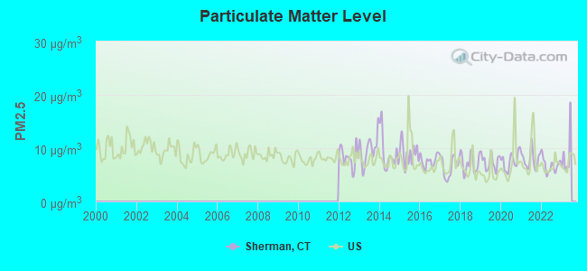
Particulate Matter (PM2.5) [µg/m3] level in 2022 was 6.76. This is about average. Closest monitor was 12.3 miles away from the city center.
| City: | 6.76 |
| U.S.: | 8.11 |
Tornado activity:
Sherman-area historical tornado activity is near Connecticut state average. It is 26% smaller than the overall U.S. average.
On 7/10/1989, a category F4 (max. wind speeds 207-260 mph) tornado 33.8 miles away from the Sherman town center injured 40 people and caused between $50,000,000 and $500,000,000 in damages.
On 5/24/1962, a category F3 (max. wind speeds 158-206 mph) tornado 19.7 miles away from the town center killed one person and injured 50 people and caused between $500,000 and $5,000,000 in damages.
Earthquake activity:
Sherman-area historical earthquake activity is significantly above Connecticut state average. It is 69% smaller than the overall U.S. average.On 10/7/1983 at 10:18:46, a magnitude 5.3 (5.1 MB, 5.3 LG, 5.1 ML, Class: Moderate, Intensity: VI - VII) earthquake occurred 170.1 miles away from Sherman center
On 4/20/2002 at 10:50:47, a magnitude 5.3 (5.3 ML, Depth: 3.0 mi) earthquake occurred 203.6 miles away from the city center
On 4/20/2002 at 10:50:47, a magnitude 5.2 (5.2 MB, 4.2 MS, 5.2 MW, 5.0 MW) earthquake occurred 201.9 miles away from Sherman center
On 8/23/2011 at 17:51:04, a magnitude 5.8 (5.8 MW, Depth: 3.7 mi) earthquake occurred 346.1 miles away from Sherman center
On 1/19/1982 at 00:14:42, a magnitude 4.7 (4.5 MB, 4.7 MD, 4.5 LG, Class: Light, Intensity: IV - V) earthquake occurred 164.7 miles away from Sherman center
On 1/16/1994 at 01:49:16, a magnitude 4.6 (4.6 MB, 4.6 LG, Depth: 3.1 mi) earthquake occurred 158.0 miles away from the city center
Magnitude types: regional Lg-wave magnitude (LG), body-wave magnitude (MB), duration magnitude (MD), local magnitude (ML), surface-wave magnitude (MS), moment magnitude (MW)
Natural disasters:
The number of natural disasters in Fairfield County (24) is greater than the US average (15).Major Disasters (Presidential) Declared: 13
Emergencies Declared: 11
Causes of natural disasters: Storms: 6, Floods: 5, Hurricanes: 5, Snowstorms: 4, Blizzards: 3, Snows: 3, Winter Storms: 3, Tropical Storms: 2, Snowfall: 1, Wind: 1 (Note: some incidents may be assigned to more than one category).

Hospitals and medical centers near Sherman:
- NEW MILFORD HOSPITAL Acute Care Hospitals (about 5 miles away; NEW MILFORD, CT)
- VILLAGE CREST CENTER FOR HEALTH AND REHABILITATION (Nursing Home, about 5 miles away; NEW MILFORD, CT)
- DUTCHESS CENTER FOR REHAB AND HEALTHCARE (Nursing Home, about 5 miles away; PAWLING, NY)
- ABILITY BEYOND DISABILITY LANE (Hospital, about 5 miles away; NEW MILFORD, CT)
- NEW MILFORD VNA INC (Home Health Center, about 6 miles away; NEW MILFORD, CT)
- CANDLEWOOD VALLEY HEALTH AND R (Nursing Home, about 6 miles away; NEW MILFORD, CT)
- ABILITY BEYOND DISABILITY GREE (Hospital, about 7 miles away; NEW MILFORD, CT)
Colleges/universities with over 2000 students nearest to Sherman:
- Western Connecticut State University (about 13 miles; Danbury, CT; Full-time enrollment: 5,345)
- Post University (about 22 miles; Waterbury, CT; FT enrollment: 5,808)
- Vassar College (about 22 miles; Poughkeepsie, NY; FT enrollment: 2,469)
- Naugatuck Valley Community College (about 23 miles; Waterbury, CT; FT enrollment: 4,491)
- Dutchess Community College (about 24 miles; Poughkeepsie, NY; FT enrollment: 6,554)
- University of Connecticut-Tri-Campus (about 24 miles; Waterbury, CT; FT enrollment: 2,250)
- Marist College (about 25 miles; Poughkeepsie, NY; FT enrollment: 5,536)
Points of interest:
Notable locations in Sherman: Camp Mauwehu (A), Camp Allen (B), Sherman Library (C), Sherman Volunteer Fire Department (D), Sherman Fire Marshal's Office (E). Display/hide their locations on the map
Church in Sherman: Sherman Church (A). Display/hide its location on the map
Cemeteries: Coburn Cemetery (1), Sherman Center Cemetery (2), North Cemetery (3). Display/hide their locations on the map
Lakes, reservoirs, and swamps: Timber Lake (A), Valley Pond (B), Deer Pond (C), Green Pond (D), Haviland Millpond (E), Jennings Pond (F), Spring Lake (G), Timber Lake (H). Display/hide their locations on the map
Streams, rivers, and creeks: Sawmill Brook (A), Glen Brook (B), Greenwood Brook (C), Tollgate Brook (D). Display/hide their locations on the map
Parks in Sherman include: Colonial Park (1), Sherman Town Park (2). Display/hide their locations on the map
Beach: Pine Ledge (A). Display/hide its location on the map
| This town: | 2.6 people |
| Connecticut: | 2.5 people |
| This town: | 74.1% |
| Whole state: | 66.3% |
| This town: | 6.2% |
| Whole state: | 6.6% |
Likely homosexual households (counted as self-reported same-sex unmarried-partner households)
- Lesbian couples: 0.6% of all households
- Gay men: 1.1% of all households
| This town: | 3.1% |
| Whole state: | 7.9% |
| This town: | 1.4% |
| Whole state: | 3.9% |
Banks with branches in Sherman (2011 data):
- Webster Bank, National Association: Sherman Branch at Routes 37 And 39, branch established on 1976/02/09. Info updated 2008/12/23: Bank assets: $18,674.3 mil, Deposits: $13,861.5 mil, headquarters in Waterbury, CT, positive income, Commercial Lending Specialization, 167 total offices, Holding Company: Webster Financial Corporation
For population 15 years and over in Sherman:
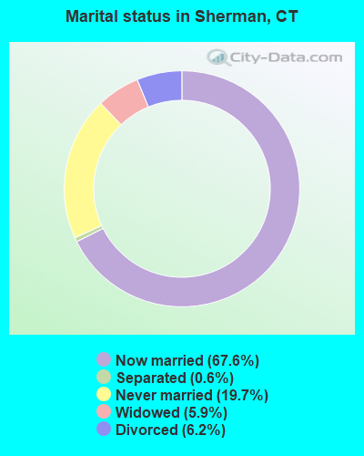
- Never married: 19.7%
- Now married: 67.6%
- Separated: 0.6%
- Widowed: 5.9%
- Divorced: 6.2%
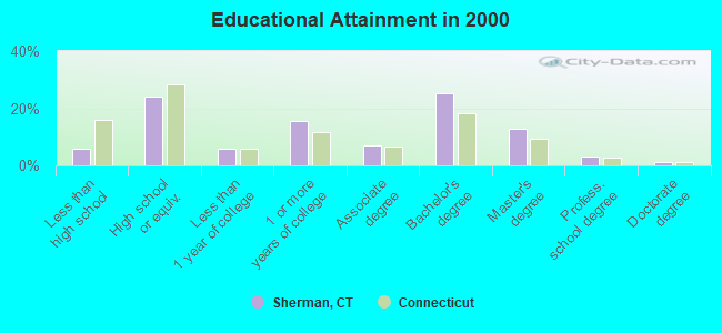
For population 25 years and over in Sherman:
- High school or higher: 94.3%
- Bachelor's degree or higher: 42.3%
- Graduate or professional degree: 17.0%
- Unemployed: 2.3%
- Mean travel time to work (commute): 38.8 minutes
| Here: | 9.8 |
| Connecticut average: | 12.8 |
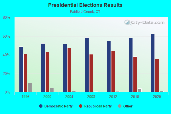
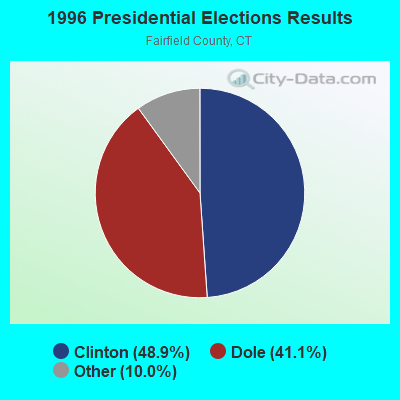
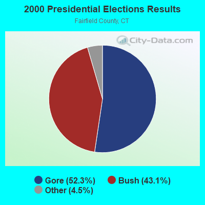
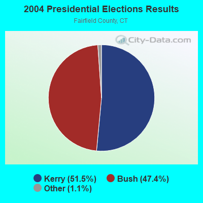
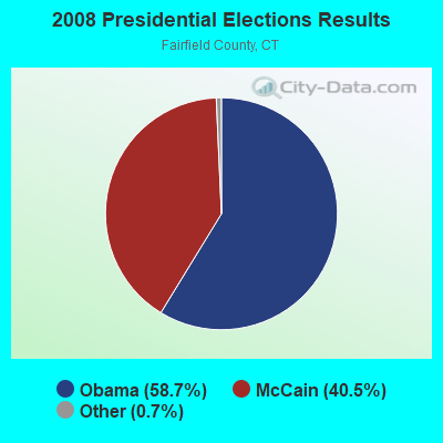
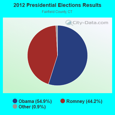
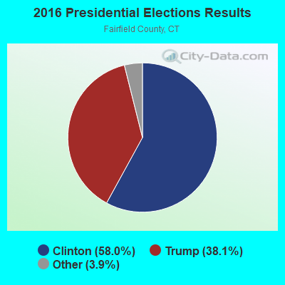
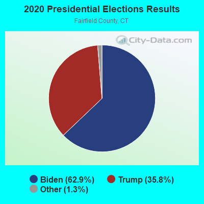
Graphs represent county-level data. Detailed 2008 Election Results
Religion statistics for Sherman, CT (based on Fairfield County data)
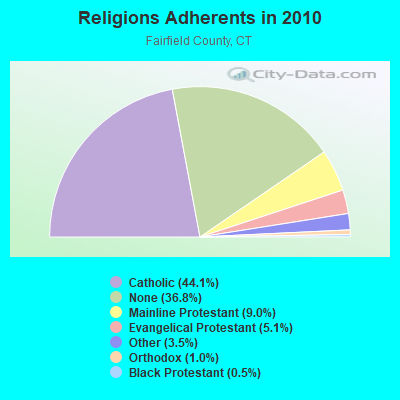
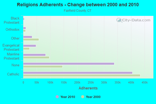
| Religion | Adherents | Congregations |
|---|---|---|
| Catholic | 404,341 | 94 |
| Mainline Protestant | 82,604 | 175 |
| Evangelical Protestant | 46,888 | 242 |
| Other | 32,501 | 95 |
| Orthodox | 9,215 | 21 |
| Black Protestant | 4,144 | 27 |
| None | 337,136 | - |
Food Environment Statistics:
| Fairfield County: | 2.50 / 10,000 pop. |
| Connecticut: | 2.21 / 10,000 pop. |
| This county: | 0.06 / 10,000 pop. |
| Connecticut: | 0.07 / 10,000 pop. |
| Fairfield County: | 0.85 / 10,000 pop. |
| Connecticut: | 1.02 / 10,000 pop. |
| This county: | 1.70 / 10,000 pop. |
| Connecticut: | 2.27 / 10,000 pop. |
| This county: | 9.67 / 10,000 pop. |
| Connecticut: | 9.19 / 10,000 pop. |
| Fairfield County: | 6.5% |
| Connecticut: | 7.3% |
| This county: | 17.9% |
| Connecticut: | 21.5% |
| This county: | 17.2% |
| Connecticut: | 15.8% |
5.92% of this county's 2021 resident taxpayers lived in other counties in 2020 ($194,373 average adjusted gross income)
| Here: | 5.92% |
| Connecticut average: | 5.79% |
0.01% of residents moved from foreign countries ($50 average AGI)
Fairfield County: 0.01% Connecticut average: 0.02%
Top counties from which taxpayers relocated into this county between 2020 and 2021:
| from Westchester County, NY | |
| from New York County, NY | |
| from New Haven County, CT |
6.13% of this county's 2020 resident taxpayers moved to other counties in 2021 ($174,109 average adjusted gross income)
| Here: | 6.13% |
| Connecticut average: | 5.82% |
0.01% of residents moved to foreign countries ($428 average AGI)
Fairfield County: 0.01% Connecticut average: 0.02%
Top counties to which taxpayers relocated from this county between 2020 and 2021:
| to New Haven County, CT | |
| to New York County, NY | |
| to Westchester County, NY |
Strongest AM radio stations in Sherman:
- WTIC (1080 AM; 50 kW; HARTFORD, CT; Owner: INFINITY RADIO OPERATIONS INC.)
- WFAN (660 AM; 50 kW; NEW YORK, NY; Owner: INFINITY BROADCASTING OPERATIONS, INC.)
- WNNZ (640 AM; 50 kW; WESTFIELD, MA; Owner: CLEAR CHANNEL BROADCASTING LICENSES, INC.)
- WCBS (880 AM; 50 kW; NEW YORK, NY; Owner: INFINITY BROADCASTING OPERATIONS, INC.)
- WABC (770 AM; 50 kW; NEW YORK, NY; Owner: WABC-AM RADIO, INC.)
- WMCA (570 AM; 50 kW; NEW YORK, NY; Owner: SALEM MEDIA OF NEW YORK, LLC)
- WOR (710 AM; 50 kW; NEW YORK, NY; Owner: BUCKLEY BROADCASTING CORPORATION)
- WINE (940 AM; 1 kW; BROOKFIELD, CT; Owner: CUMULUS LICENSING CORP.)
- WGSM (740 AM; 25 kW; HUNTINGTON, NY; Owner: K RADIO LICENSEE, INC.)
- WEPN (1050 AM; 50 kW; NEW YORK, NY; Owner: NEW YORK AM RADIO, LLC)
- WINS (1010 AM; 50 kW; NEW YORK, NY; Owner: INFINITY BROADCASTING OPERATIONS, INC.)
- WBBR (1130 AM; 50 kW; NEW YORK, NY; Owner: BLOOMBERG COMMUNICATIONS INC.)
- WADO (1280 AM; 50 kW; NEW YORK, NY; Owner: WADO-AM LICENSE CORP.)
Strongest FM radio stations in Sherman:
- WRKI (95.1 FM; BROOKFIELD, CT; Owner: CUMULUS LICENSING CORP.)
- WDBY (105.5 FM; PATTERSON, NY; Owner: CUMULUS LICENSING CORP.)
- W206AW (89.1 FM; PAWLING, NY; Owner: SOUND OF LIFE, INC.)
- WRNQ (92.1 FM; POUGHKEEPSIE, NY; Owner: CLEAR CHANNEL BROADCASTING LICENSES, INC.)
- WPDH (101.5 FM; POUGHKEEPSIE, NY; Owner: CUMULUS LICENSING CORP.)
- WSPK (104.7 FM; POUGHKEEPSIE, NY; Owner: 6 JOHNSON ROAD LICENSES, INC.)
- W218AV (91.5 FM; WARREN, CT; Owner: MONROE BOARD OF EDUCATION)
- WDAQ (98.3 FM; DANBURY, CT; Owner: BERKSHIRE BROADCASTING CORP.)
- WFNP (88.7 FM; ROSENDALE, NY; Owner: STATE UNIVERSITY OF NEW YORK)
- WRHV (88.7 FM; POUGHKEEPSIE, NY; Owner: WMHT EDUCATIONAL TELECOMMUNICATIONS)
- WQQQ (103.3 FM; SHARON, CT; Owner: THE RIDGEFIELD BROADCASTING CORPORATION)
- WCZX (97.7 FM; HYDE PARK, NY; Owner: CUMULUS LICENSING CORP.)
- WRRB (96.9 FM; ARLINGTON, NY; Owner: CUMULUS LICENSING CORP.)
- WBWZ (93.3 FM; NEW PALTZ, NY; Owner: CLEVELAND RADIO LICENSES, LLC)
- WRWD-FM (107.3 FM; HIGHLAND, NY; Owner: CLEVELAND RADIO LICENSES, LLC)
- WKCI-FM (101.3 FM; HAMDEN, CT; Owner: CLEAR CHANNEL BROADCASTING LICENSES, INC.)
- WRCH (100.5 FM; NEW BRITAIN, CT; Owner: INFINITY RADIO OPERATIONS INC.)
- WFKP (99.3 FM; ELLENVILLE, NY; Owner: CLEAR CHANNEL BROADCASTING LICENSES, INC.)
- WPLR (99.1 FM; NEW HAVEN, CT; Owner: COX RADIO, INC.)
- W292CM (106.3 FM; POUGHKEEPSIE, NY; Owner: JOHN KATONAH)
TV broadcast stations around Sherman:
- WTIC-TV (Channel 61; HARTFORD, CT; Owner: TRIBUNE TELEVISION COMPANY)
- W11BJ (Channel 11; HARTFORD, CT; Owner: COMMUNICATIONS SITE MANAGEMENT LLC)
- WTBY (Channel 54; POUGHKEEPSIE, NY; Owner: TRINITY BROADCASTING OF NEW YORK, INC.)
- WTXX (Channel 20; WATERBURY, CT; Owner: WTXX INC.)
- WVIT (Channel 30; NEW BRITAIN, CT; Owner: OUTLET BROADCASTING, INC)
- WTNH (Channel 8; NEW HAVEN, CT; Owner: WTNH BROADCASTING, INC.)
- WEDH (Channel 24; HARTFORD, CT; Owner: CONNECTICUT PUBLIC BROADCASTING, INC.)
- WUVN (Channel 18; HARTFORD, CT; Owner: ENTRAVISION HOLDINGS, LLC)
- WCTX (Channel 59; NEW HAVEN, CT; Owner: WTNH BROADCASTING, INC.)
- WEDY (Channel 65; NEW HAVEN, CT; Owner: CONNECTICUT PUBLIC BROADCASTING, INC.)
- WEDW (Channel 49; BRIDGEPORT, CT; Owner: CONNECTICUT PUBLIC BROADCASTING, INC.)
- WRNN-TV (Channel 62; KINGSTON, NY; Owner: WRNN-TV ASSOCIATES LIMITED PARTNERSHIP)
- W22BN (Channel 22; DANBURY, CT; Owner: it COMMUNICATIONS, INC.)
- National Bridge Inventory (NBI) Statistics
- 7Number of bridges
- 23ft / 6.7mTotal length
- 8,616Total average daily traffic
- 376Total average daily truck traffic
- 12,803Total future (year 2035) average daily traffic
FCC Registered Cell Phone Towers:
2- 2 Taber Rd (26030) (Lat: 41.612583 Lon: -73.503861), Type: Silo, Structure height: 18.6 m, Overall height: 21.9 m, Call Sign: KNKA256
Assigned Frequencies: 880.020 MHz, 880.020 MHz, 880.020 MHz, 835.020 MHz, 835.020 MHz, 835.020 MHz, 891.510 MHz, 891.510 MHz, 891.510 MHz, 846.510 MHz, 846.510 MHz, 846.510 MHzGrant Date: 09/03/2014, Expiration Date: 10/01/2024, Certifier: David C JatlowRegistrant: At&t Services, Inc., 208 S Akard St, 20f, Dallas, TX 75202, Phone: (855) 699-7073, Fax: (214) 746-6410, Email:
- 32 Route 37 East (Lat: 41.583972 Lon: -73.480111), Type: Silo, Structure height: 18.9 m, Call Sign: KNKA363
Assigned Frequencies: 869.040 MHz, 869.040 MHz, 869.040 MHz, 824.040 MHz, 824.040 MHz, 824.040 MHz, 890.010 MHz, 890.010 MHz, 890.010 MHz, 845.010 MHz, 845.010 MHz, 845.010 MHzGrant Date: 02/02/2018, Expiration Date: 01/22/2028Registrant: Verizon Wireless, 5055 North Point Pkwy, Np2ne Network Engineering, Alpharetta, GA 30022, Phone: (770) 797-1070, Fax: (678) 259-1319, Email:
FCC Registered Broadcast Land Mobile Towers:
3- Sawmill River Rd Ext (Lat: 41.572583 Lon: -73.492056), Call Sign: KRJ808,
Assigned Frequencies: 155.835 MHz, Grant Date: 03/06/2000, Expiration Date: 05/02/2005, Cancellation Date: 04/08/2002, Registrant: Lake Candlewood Lake Authority, Sherman, CT 06784, Phone: (203) 354-6928
- SHERMAN FIRE, 1 Route 39 North (Lat: 41.579806 Lon: -73.497306), Type: Building, Structure height: 10 m, Call Sign: WPTL623,
Assigned Frequencies: 155.107 MHz, 155.122 MHz, Grant Date: 08/04/2021, Expiration Date: 10/25/2031, Certifier: Alan T Gawel, Registrant: Northeastern Communications Inc., 7 Great Hill Rd, Naugatuck, CT 06077, Phone: (203) 575-9008, Email:
- Lat: 41.645917 Lon: -73.490667, Call Sign: WPVP953,
Assigned Frequencies: 451.187 MHz, 456.187 MHz, Grant Date: 07/30/2002, Expiration Date: 07/30/2012, Cancellation Date: 09/29/2012, Certifier: Pam Mccloskey, Registrant: Cara Enterprises Inc, Salt Lake City, UT 84117-0503, Phone: (801) 278-9728, Fax: (801) 278-7239
FCC Registered Maritime Coast & Aviation Ground Towers:
1- 20 Saw Mill Rd (Lat: 41.572583 Lon: -73.492056), Type: Building, Overall height: 6 m, Call Sign: WHU690,
Assigned Frequencies: 156.450 MHz, 156.425 MHz, 156.800 MHz, Grant Date: 03/07/2022, Expiration Date: 03/12/2032, Registrant: Candlewood Lake Authority, 20 Saw Mill Road, Sherman, CT 06784, Phone: (860) 354-6928, Email:
FCC Registered Amateur Radio Licenses:
23 (See the full list of FCC Registered Amateur Radio Licenses in Sherman)FAA Registered Aircraft:
14 (See the full list of FAA Registered Aircraft in Sherman)2002 - 2018 National Fire Incident Reporting System (NFIRS) incidents
- Fire incident types reported to NFIRS in Sherman, CT
- 9550.0%Structure Fires
- 5428.4%Outside Fires
- 2211.6%Other
- 1910.0%Mobile Property/Vehicle Fires
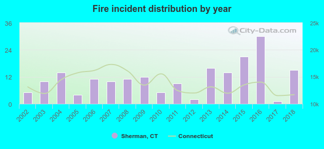 Based on the data from the years 2002 - 2018 the average number of fire incidents per year is 11. The highest number of reported fire incidents - 30 took place in 2016, and the least - 1 in 2017. The data has an increasing trend.
 When looking into fire subcategories, the most incidents belonged to: Structure Fires (50.0%), and Outside Fires (28.4%).
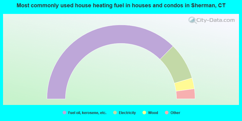
- 74.8%Fuel oil, kerosene, etc.
- 16.1%Electricity
- 4.7%Wood
- 3.7%Bottled, tank, or LP gas
- 0.4%Coal or coke
- 0.4%Other fuel
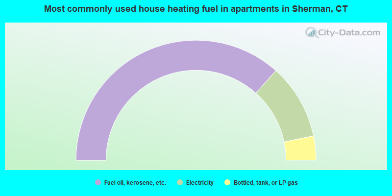
- 73.2%Fuel oil, kerosene, etc.
- 20.3%Electricity
- 6.5%Bottled, tank, or LP gas
Sherman compared to Connecticut state average:
- Median house value above state average.
- Unemployed percentage significantly below state average.
- Black race population percentage significantly below state average.
- Hispanic race population percentage significantly below state average.
- Median age significantly above state average.
- Foreign-born population percentage below state average.
- Renting percentage significantly below state average.
- Length of stay since moving in significantly above state average.
- Number of rooms per house significantly below state average.
- House age significantly below state average.

|
|
Total of 111 patent applications in 2008-2024.