Spence, Georgia
Submit your own pictures of this place and show them to the world
- OSM Map
- General Map
- Google Map
- MSN Map

| Males: 741 | |
| Females: 773 |
| Median resident age: | 37.1 years |
| Georgia median age: | 33.4 years |
Zip code: 31779
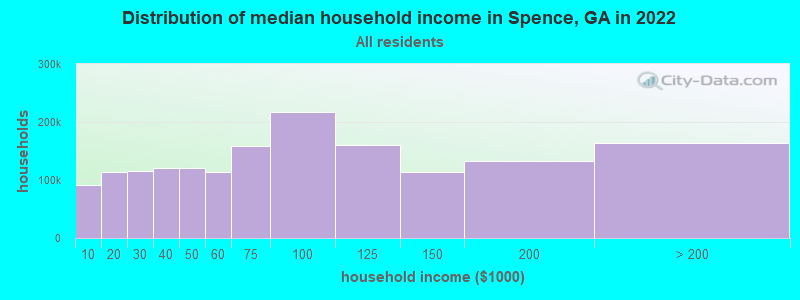
| Spence: | $62,795 |
| GA: | $72,837 |
Estimated per capita income in 2022: $30,298 (it was $15,862 in 2000)
Spence CCD income, earnings, and wages data
Estimated median house or condo value in 2022: $176,123 (it was $63,500 in 2000)
| Spence: | $176,123 |
| GA: | $297,400 |
Detailed information about poverty and poor residents in Spence, GA
Compare current foreclosures near Spence, GA:
| Photo | Address | Area | Beds / Baths | Price | Details |
|---|---|---|---|---|---|

|
#1
4th Ave SW
Cairo, GA 39828
|
1,372 sq. feet
|
1 baths 3 beds |
$175,000
|
show details |

|
#2
E Broad St
Camilla, GA 31730
|
2,599 sq. feet
|
3 baths 4 beds |
show details | |

|
#3
Deer Hill Dr
Ochlocknee, GA 31773
|
1,460 sq. feet
|
2 baths 3 beds |
show details | |

|
#4
Sunset Ln
Cairo, GA 39828
|
- sq. feet
|
2 baths 3 beds |
show details | |

|
#5
Lake Shore Dr
Thomasville, GA 31757
|
1,356 sq. feet
|
2 baths 3 beds |
show details | |

|
#6
Willow Ridge Cir
Thomasville, GA 31757
|
2,670 sq. feet
|
3 baths 4 beds |
show details | |

|
#7
Festus St
Thomasville, GA 31792
|
1,170 sq. feet
|
1 baths - beds |
show details | |

|
#8
Willow Ridge Cir
Thomasville, GA 31757
|
2,747 sq. feet
|
2 baths - beds |
show details | |

|
#9
Furlow St
Camilla, GA 31730
|
1,005 sq. feet
|
1 baths - beds |
show details | |

|
#10
Newton St
Camilla, GA 31730
|
1,425 sq. feet
|
1 baths - beds |
show details |
| Photo | Address | Area | Beds / Baths | Price | Details |
|---|---|---|---|---|---|

|
#11
Kennedy St
Camilla, GA 31730
|
960 sq. feet
|
1 baths - beds |
show details | |

|
#12
Old Ga Highway 3
Camilla, GA 31730
|
1,238 sq. feet
|
1 baths - beds |
show details | |

|
#13
Hilltop Cir
Camilla, GA 31730
|
1,844 sq. feet
|
1 baths - beds |
show details | |

|
#14
Goodson Rd
Camilla, GA 31730
|
988 sq. feet
|
1 baths - beds |
show details | |

|
#15
Dogwood St
Camilla, GA 31730
|
1,080 sq. feet
|
1 baths - beds |
show details | |

|
#16
Cedar Ln
Camilla, GA 31730
|
1,374 sq. feet
|
1 baths - beds |
show details | |

|
#17
Ga Highway 3
Ochlocknee, GA 31773
|
1,166 sq. feet
|
1 baths - beds |
show details | |

|
#18
Mcmillan Rd
Ochlocknee, GA 31773
|
2,268 sq. feet
|
2 baths - beds |
show details | |

|
#19
Newton Rd
Camilla, GA 31730
|
1,127 sq. feet
|
1 baths - beds |
show details | |

|
#20
Ga Highway 37
Camilla, GA 31730
|
2,428 sq. feet
|
1 baths - beds |
show details |
| Photo | Address | Area | Beds / Baths | Price | Details |
|---|---|---|---|---|---|

|
#21
Willow Ridge Cir
Thomasville, GA 31757
|
3,150 sq. feet
|
3 baths - beds |
show details | |

|
#22
Saco Church Rd
Pelham, GA 31779
|
1,424 sq. feet
|
1 baths - beds |
show details | |

|
#23
Shauna Rd
Ochlocknee, GA 31773
|
2,288 sq. feet
|
2 baths - beds |
show details | |

|
#24
S Macarthur Dr
Camilla, GA 31730
|
1,616 sq. feet
|
1 baths - beds |
show details | |

|
#25
Court Dr
Camilla, GA 31730
|
1,250 sq. feet
|
1 baths - beds |
show details | |

|
#26
Doe Run Cir
Thomasville, GA 31757
|
1,182 sq. feet
|
2 baths - beds |
show details | |

|
#27
Lincoln St
Camilla, GA 31730
|
1,100 sq. feet
|
1 baths - beds |
show details | |

|
#28
W Morgan St
Camilla, GA 31730
|
1,108 sq. feet
|
1 baths - beds |
show details | |

|
#29
Thomas St
Camilla, GA 31730
|
1,566 sq. feet
|
1 baths - beds |
show details | |

|
#30
Thomas St
Camilla, GA 31730
|
1,218 sq. feet
|
1 baths - beds |
show details |
| Photo | Address | Area | Beds / Baths | Price | Details |
|---|---|---|---|---|---|

|
#31
Wiregrass Rd
Camilla, GA 31730
|
1,633 sq. feet
|
1 baths - beds |
show details | |

|
#32
Limousin Ln
Thomasville, GA 31792
|
2,500 sq. feet
|
3 baths - beds |
show details | |

|
#33
Pine St
Camilla, GA 31730
|
1,300 sq. feet
|
1 baths - beds |
show details | |

|
#34
Macdonald St
Camilla, GA 31730
|
1,349 sq. feet
|
1 baths - beds |
show details | |

|
#35
Morningside Dr
Camilla, GA 31730
|
1,430 sq. feet
|
1 baths - beds |
show details | |

|
#36
Lincoln Pl
Camilla, GA 31730
|
970 sq. feet
|
1 baths - beds |
show details | |

|
#37
Shiver Dr
Camilla, GA 31730
|
1,232 sq. feet
|
1 baths - beds |
show details | |

|
#38
Highland St
Thomasville, GA 31792
|
1,312 sq. feet
|
2 baths - beds |
show details | |

|
#39
Stubbs St
Ochlocknee, GA 31773
|
1,604 sq. feet
|
1 baths - beds |
show details | |

|
#40
Dixie Chastain Rd
Ochlocknee, GA 31773
|
1,820 sq. feet
|
2 baths - beds |
show details |
| Photo | Address | Area | Beds / Baths | Price | Details |
|---|---|---|---|---|---|

|
#41
John Collins Rd
Pelham, GA 31779
|
1,593 sq. feet
|
1 baths - beds |
show details | |

|
#42
Kenley Ln
Thomasville, GA 31792
|
1,606 sq. feet
|
2 baths - beds |
show details | |

|
#43
Oak St SW
Pelham, GA 31779
|
1,065 sq. feet
|
1 baths - beds |
show details | |

|
#44
N Dawson St # B
Thomasville, GA 31792
|
1,428 sq. feet
|
2 baths - beds |
show details | |

|
#45
Glausier St SE
Pelham, GA 31779
|
1,200 sq. feet
|
1 baths - beds |
show details | |

|
#46
Pipeline Rd
Camilla, GA 31730
|
1,350 sq. feet
|
1 baths - beds |
show details | |

|
#47
Barnes St
Thomasville, GA 31792
|
852 sq. feet
|
1 baths - beds |
show details | |

|
#48
Everett Aly SE
Pelham, GA 31779
|
1,024 sq. feet
|
1 baths - beds |
show details | |

|
#49
W Merrill St
Thomasville, GA 31792
|
1,219 sq. feet
|
1 baths - beds |
show details | |

|
Check over 1 million property listings on Foreclosure.com!
|
browse all offers | |||

- 1,31291.2%White alone
- 906.3%Black alone
- 201.4%Hispanic
- 141.0%American Indian alone
- 20.1%Two or more races
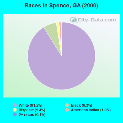
Races in Spence detailed stats: ancestries, foreign born residents, place of birth
 Recent articles from our blog. Our writers, many of them Ph.D. graduates or candidates, create easy-to-read articles on a wide variety of topics.
Current Local Time: EST time zone
Elevation: 322 feet
Land area: 53.6 square miles.
Population density: 28 people per square mile (very low).

| Spence CCD: | 0.8% ($522) |
| Georgia: | 0.9% ($919) |
Nearest city with pop. 50,000+: West Dougherty, GA (37.8 miles  , pop. 59,680).
Nearest city with pop. 200,000+: Montgomery, AL (154.2 miles , pop. 201,568).
Nearest city with pop. 1,000,000+: Houston, TX (674.1 miles , pop. 1,953,631).
Nearest cities:
), ), )Latitude: 31.03 N, Longitude: 84.17 W
Area code commonly used in this area: 229

| Here: | 2.8% |
| Georgia: | 2.9% |
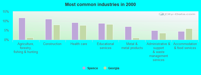
- Agriculture, forestry, fishing & hunting (11.6%)
- Construction (11.0%)
- Health care (9.2%)
- Educational services (8.8%)
- Metal & metal products (7.0%)
- Administrative & support & waste management services (4.9%)
- Accommodation & food services (4.5%)
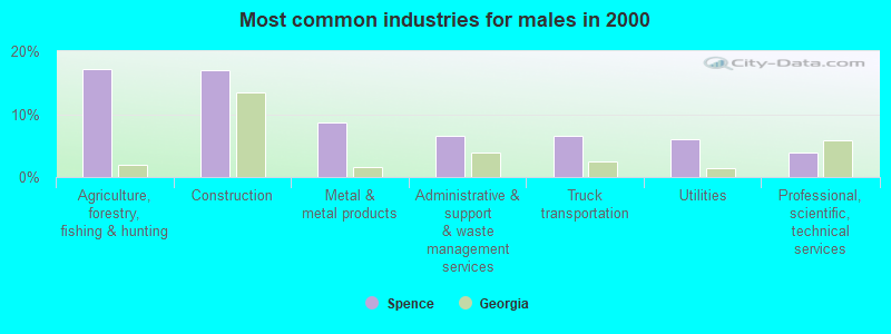
- Agriculture, forestry, fishing & hunting (17.2%)
- Construction (17.0%)
- Metal & metal products (8.7%)
- Administrative & support & waste management services (6.5%)
- Truck transportation (6.5%)
- Utilities (6.1%)
- Professional, scientific, technical services (3.9%)
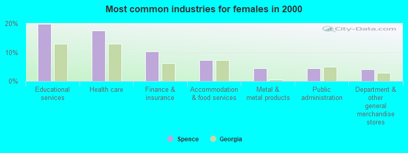
- Educational services (19.7%)
- Health care (17.5%)
- Finance & insurance (10.2%)
- Accommodation & food services (7.3%)
- Metal & metal products (4.5%)
- Public administration (4.5%)
- Department & other general merchandise stores (4.1%)
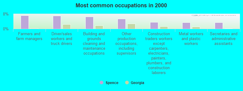
- Farmers and farm managers (7.2%)
- Driver/sales workers and truck drivers (7.0%)
- Building and grounds cleaning and maintenance occupations (6.5%)
- Other production occupations, including supervisors (5.4%)
- Construction traders workers except carpenters, electricians, painters, plumbers, and construction laborers (3.6%)
- Metal workers and plastic workers (3.5%)
- Secretaries and administrative assistants (3.4%)
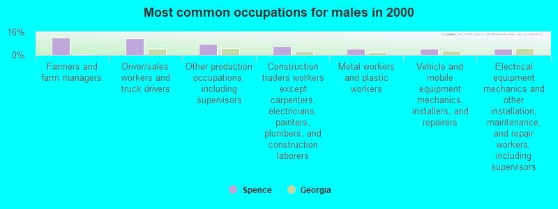
- Farmers and farm managers (12.2%)
- Driver/sales workers and truck drivers (11.8%)
- Other production occupations, including supervisors (7.6%)
- Construction traders workers except carpenters, electricians, painters, plumbers, and construction laborers (6.1%)
- Metal workers and plastic workers (4.6%)
- Vehicle and mobile equipment mechanics, installers, and repairers (4.1%)
- Electrical equipment mechanics and other installation, maintenance, and repair workers, including supervisors (4.1%)
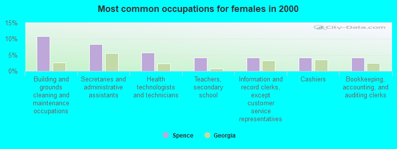
- Building and grounds cleaning and maintenance occupations (10.8%)
- Secretaries and administrative assistants (8.3%)
- Health technologists and technicians (5.7%)
- Teachers, secondary school (4.1%)
- Information and record clerks, except customer service representatives (4.1%)
- Cashiers (4.1%)
- Bookkeeping, accounting, and auditing clerks (4.1%)
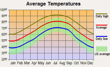
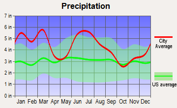
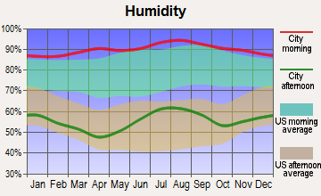
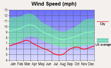
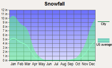
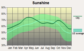
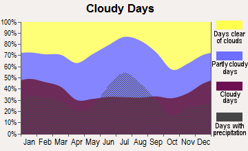
Average climate in Spence, Georgia
Based on data reported by over 4,000 weather stations
Tornado activity:
Spence-area historical tornado activity is near Georgia state average. It is 35% greater than the overall U.S. average.
On 2/13/2000, a category F3 (max. wind speeds 158-206 mph) tornado 1.7 miles away from the Spence place center killed 6 people and injured 15 people and caused $5 million in damages.
On 2/13/2000, a category F3 tornado 11.1 miles away from the place center killed 11 people and injured 175 people and caused $20 million in damages.
Earthquake activity:
Spence-area historical earthquake activity is significantly above Georgia state average. It is 22% smaller than the overall U.S. average.On 10/24/1997 at 08:35:17, a magnitude 4.9 (4.8 MB, 4.2 MS, 4.9 LG, Depth: 6.2 mi, Class: Light, Intensity: IV - V) earthquake occurred 183.6 miles away from the city center
On 8/2/1974 at 08:52:09, a magnitude 4.9 (4.3 MB, 4.9 LG) earthquake occurred 219.7 miles away from Spence center
On 4/29/2003 at 08:59:39, a magnitude 4.9 (4.4 MB, 4.6 MW, 4.9 LG) earthquake occurred 253.9 miles away from the city center
On 1/18/1999 at 07:00:53, a magnitude 4.8 (4.8 MB, 4.0 LG, Depth: 0.6 mi) earthquake occurred 243.7 miles away from Spence center
On 11/22/1974 at 05:25:55, a magnitude 4.7 (4.7 MB) earthquake occurred 269.4 miles away from the city center
On 4/29/2003 at 08:59:39, a magnitude 4.6 (4.6 MW, Depth: 12.3 mi) earthquake occurred 253.9 miles away from the city center
Magnitude types: regional Lg-wave magnitude (LG), body-wave magnitude (MB), surface-wave magnitude (MS), moment magnitude (MW)
Natural disasters:
The number of natural disasters in Grady County (10) is smaller than the US average (15).Major Disasters (Presidential) Declared: 6
Emergencies Declared: 3
Causes of natural disasters: Tornadoes: 4, Floods: 3, Hurricanes: 2, Storms: 2, Winds: 2, Drought: 1, Heavy Rain: 1, Snowfall: 1, Tropical Storm: 1, Winter Storm: 1, Other: 1 (Note: some incidents may be assigned to more than one category).
Hospitals and medical centers near Spence:
- PELHAM PARKWAY NH (Nursing Home, about 8 miles away; PELHAM, GA)
- GRADY COUNTY DIALYSIS FACILITY (Dialysis Facility, about 12 miles away; CAIRO, GA)
- MITCHELL COUNTY HOSPITAL Critical Access Hospitals (about 14 miles away; CAMILLA, GA)
- MITCHELL COUNTY NURSING HOMES (Nursing Home, about 14 miles away; CAMILLA, GA)
Colleges/universities with over 2000 students nearest to Spence:
- Bainbridge State College (about 24 miles; Bainbridge, GA; Full-time enrollment: 2,308)
- Albany Technical College (about 37 miles; Albany, GA; FT enrollment: 3,707)
- Albany State University (about 38 miles; Albany, GA; FT enrollment: 3,662)
- Darton State College (about 39 miles; Albany, GA; FT enrollment: 5,000)
- Florida State University (about 42 miles; Tallahassee, FL; FT enrollment: 38,283)
- Tallahassee Community College (about 42 miles; Tallahassee, FL; FT enrollment: 10,904)
- Florida Agricultural and Mechanical University (about 43 miles; Tallahassee, FL; FT enrollment: 10,841)
Points of interest:
Notable location: Grady County Volunteer Fire Department Spence Station (A). Display/hide its location on the map
Churches in Spence include: Macedonia Church (A), Pine Forest Church (B), Pineview Church (C), Saint Peters Church (D), Union Hill Church (E). Display/hide their locations on the map
Cemeteries: Banks Cemetery (1), Macedonia Cemetery (2), Pine Forest Cemetery (3), Saint James Cemetery (4), Dollar Cemetery (5), Pilcher Cemetery (6). Display/hide their locations on the map
Lakes and reservoirs: Cypress Pond (A), Pritchard Pond (B), Spence Millpond (C), None None Reservoir (D). Display/hide their locations on the map
Streams, rivers, and creeks: Spence Mill Creek (A), Big Branch (B), Pilcher Creek (C). Display/hide their locations on the map
| This place: | 2.6 people |
| Georgia: | 2.6 people |
| This place: | 75.3% |
| Whole state: | 68.5% |
| This place: | 5.4% |
| Whole state: | 5.9% |
No gay or lesbian households reported
| This place: | 10.9% |
| Whole state: | 13.0% |
| This place: | 6.2% |
| Whole state: | 6.1% |
For population 15 years and over in Spence:
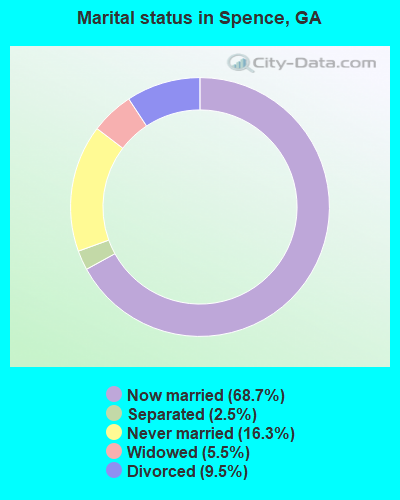
- Never married: 16.3%
- Now married: 68.7%
- Separated: 2.5%
- Widowed: 5.5%
- Divorced: 9.5%
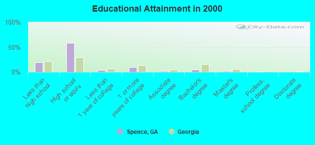
For population 25 years and over in Spence:
- High school or higher: 80.3%
- Bachelor's degree or higher: 7.4%
- Graduate or professional degree: 2.9%
- Unemployed: 3.7%
- Mean travel time to work (commute): 29.0 minutes
| Here: | 10.2 |
| Georgia average: | 13.3 |
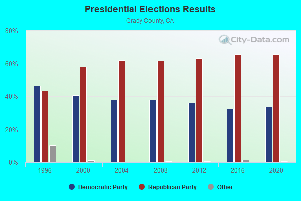
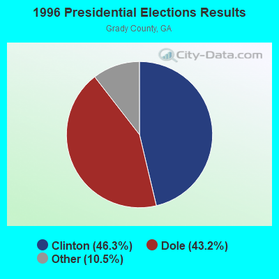
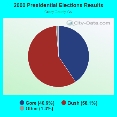

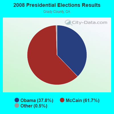
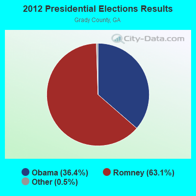


Graphs represent county-level data. Detailed 2008 Election Results
Religion statistics for Spence, GA (based on Grady County data)
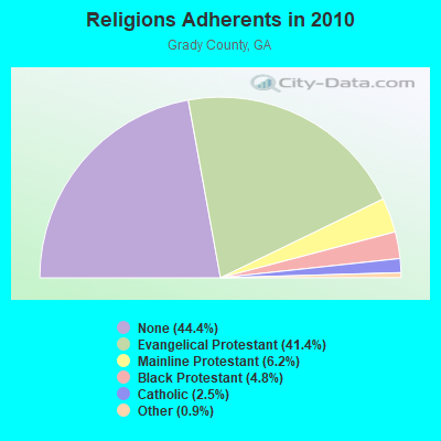
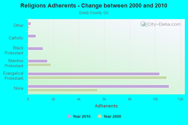
| Religion | Adherents | Congregations |
|---|---|---|
| Evangelical Protestant | 10,347 | 36 |
| Mainline Protestant | 1,539 | 12 |
| Black Protestant | 1,190 | 8 |
| Catholic | 615 | 1 |
| Other | 226 | 2 |
| None | 11,094 | - |
Food Environment Statistics:
| Grady County: | 1.61 / 10,000 pop. |
| State: | 1.91 / 10,000 pop. |
| Grady County: | 7.22 / 10,000 pop. |
| Georgia: | 5.12 / 10,000 pop. |
| Here: | 4.41 / 10,000 pop. |
| State: | 7.41 / 10,000 pop. |
| Grady County: | 12.1% |
| Georgia: | 10.4% |
| Here: | 31.3% |
| Georgia: | 27.8% |
| Grady County: | 15.0% |
| State: | 14.6% |
Strongest AM radio stations in Spence:
- WSTT (730 AM; 25 kW; THOMASVILLE, GA; Owner: MARION R. WILLIAMS)
- WJEP (1020 AM; daytime; 10 kW; OCHLOCKNEE, GA; Owner: LIFELINE MINISTRIES, INCORPORATED)
- WHGH (840 AM; daytime; 10 kW; THOMASVILLE, GA; Owner: H. G. H INVESTMENT CORP.)
- WGRA (790 AM; 1 kW; CAIRO, GA; Owner: LOVETT BROADCASTING ENTERPRISES, INC)
- WMGA (1130 AM; 10 kW; MOULTRIE, GA; Owner: RADIO MOULTRIE, INC.)
- WMGR (930 AM; 5 kW; BAINBRIDGE, GA; Owner: DECATUR BROADCASTING, INC.)
- WFVR (910 AM; 50 kW; VALDOSTA, GA; Owner: RAMA COMMUNICATIONS, INC.)
- WMTM (1300 AM; 5 kW; MOULTRIE, GA; Owner: COLQUITT BROADCASTING COMPANY, LLC)
- WFRF (1070 AM; daytime; 10 kW; TALLAHASSEE, FL; Owner: FAITH RADIO NETWORK, INC.)
- WOKV (690 AM; 50 kW; JACKSONVILLE, FL; Owner: COX RADIO, INC.)
- WJYZ (960 AM; 5 kW; ALBANY, GA; Owner: CLEAR CHANNEL BROADCASTING LICENSES, INC.)
- WMAC (940 AM; 50 kW; MACON, GA; Owner: CUMULUS LICENSING CORP.)
- WTCL (1580 AM; daytime; 10 kW; CHATTAHOOCHEE, FL; Owner: METZ, INC.)
Strongest FM radio stations in Spence:
- WRAK-FM (97.3 FM; BAINBRIDGE, GA; Owner: CLEAR CHANNEL BROADCASTING LICENSES, INC.)
- WKVH (91.9 FM; MONTICELLO, FL; Owner: EDUCATIONAL MEDIA FOUNDATION)
- WFSU-FM (88.9 FM; TALLAHASSEE, FL; Owner: FLORIDA STATE UNIVERSITY)
- WGLF (104.1 FM; TALLAHASSEE, FL; Owner: CUMULUS LICENSING CORP.)
- WWLD (102.3 FM; CAIRO, GA; Owner: CUMULUS LICENSING CORP.)
- WTLY (107.1 FM; THOMASVILLE, GA; Owner: CLEAR CHANNEL BROADCASTING LICENSES, INC.)
- WTNT-FM (94.9 FM; TALLAHASSEE, FL; Owner: CLEAR CHANNEL BROADCASTING LICENSES, INC.)
- WOBB (100.3 FM; TIFTON, GA; Owner: CLEAR CHANNEL BROADCASTING LICENSES, INC.)
- WKAK (104.5 FM; ALBANY, GA; Owner: CUMULUS LICENSING CORP.)
- WMTM-FM (93.9 FM; MOULTRIE, GA; Owner: COLQUITT BROADCASTING COMPANY, LLC)
- WTUF (106.3 FM; BOSTON, GA; Owner: BOSTON RADIO COMPANY, INC.)
- WQVE (105.5 FM; CAMILLA, GA; Owner: CUMULUS LICENSING CORP.)
- WBGE (101.9 FM; BAINBRIDGE, GA; Owner: JOHN H. WIGGINS)
TV broadcast stations around Spence:
- WABW-TV (Channel 14; PELHAM, GA; Owner: GEORGIA PUBLIC TELECOMMUNICATIONS COMMISSION)
- WTLH (Channel 49; BAINBRIDGE, GA; Owner: WTLH LICENSE CORP.)
- W19CP (Channel 19; MOULTRIE, GA; Owner: TIFT AREA TV)
- WTWC-TV (Channel 40; TALLAHASSEE, FL; Owner: WTWC LICENSEE, LLC)
- WCTV (Channel 6; THOMASVILLE, GA; Owner: WCTV LICENSEE CORP.)
- WTXL-TV (Channel 27; TALLAHASSEE, FL; Owner: MEDIA VENTURE MANAGEMENT, INC.)
- WALB (Channel 10; ALBANY, GA; Owner: LIBCO, INC.)
- WFXL (Channel 31; ALBANY, GA; Owner: WAITT LICENSE COMPANY OF GEORGIA, L.L.C.)
- W38CM (Channel 22; THOMASVILLE, GA; Owner: NATIONAL MINORITY T.V., INC.)
- W02CE (Channel 2; CAMILLA, GA; Owner: MITCHELL COUNTY TELEVISION)
- W02CI (Channel 2; CAIRO/THOMASVILLE, GA; Owner: CEE, INC.)
- WVUP-CA (Channel 45; TALLAHASSEE, FL; Owner: CHRISTIAN TELEVISION CORPORATION, INC.)
- WTBC-LP (Channel 65; TALLAHASSEE, FL; Owner: TEMPLE BAPTIST CHURCH, INC.)
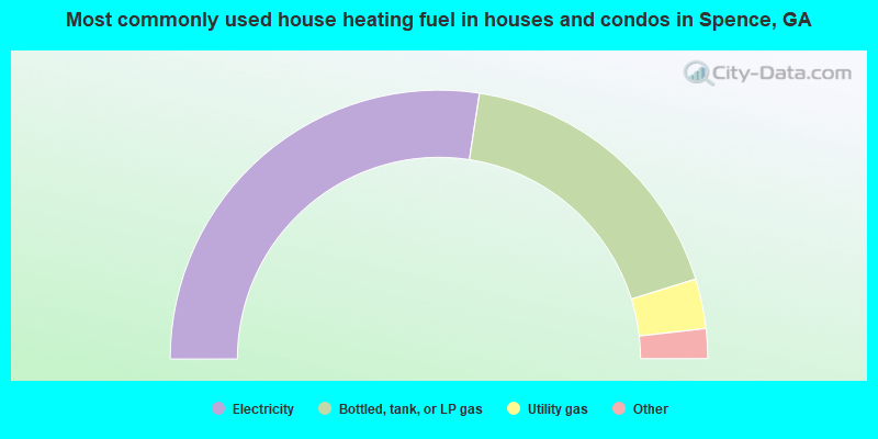
- 54.9%Electricity
- 35.6%Bottled, tank, or LP gas
- 6.0%Utility gas
- 2.2%Wood
- 1.3%Fuel oil, kerosene, etc.
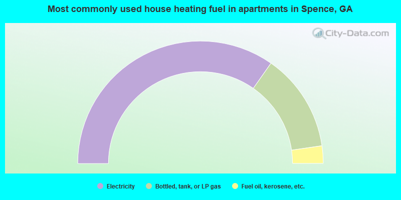
- 69.4%Electricity
- 25.9%Bottled, tank, or LP gas
- 4.6%Fuel oil, kerosene, etc.
Spence compared to Georgia state average:
- Median house value below state average.
- Unemployed percentage significantly below state average.
- Black race population percentage significantly below state average.
- Hispanic race population percentage significantly below state average.
- Foreign-born population percentage significantly below state average.
- Length of stay since moving in significantly above state average.
- Number of rooms per house significantly below state average.
- House age significantly below state average.
- Number of college students below state average.
- Percentage of population with a bachelor's degree or higher significantly below state average.