Sunderland, Massachusetts

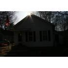
Sunderland: sunderland sunset at the old post office
Sunderland: The "Old" Grace Clark General Store
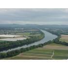
Sunderland: Skyhigh view of Sunderland, MA
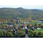
Sunderland: view from Mt Sugarloaf
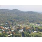
Sunderland: View of Sunderland from Mount Sugarloaf
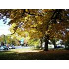
Sunderland: Sunderland, MA

Sunderland: Sunderland, MA

Sunderland: Entering Sunderland, MA
- add
your
Submit your own pictures of this town and show them to the world
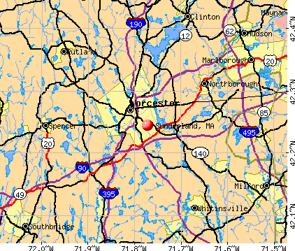
- OSM Map
- General Map
- Google Map
- MSN Map
Population change since 2000: -2.5%
 |
| Males: 1,813 | |
| Females: 1,871 |
| Median resident age: | 31.1 years |
| Massachusetts median age: | 39.2 years |
Zip codes: 01375.
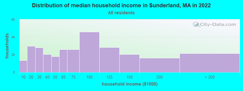
| Sunderland: | $64,061 |
| MA: | $94,488 |
Estimated per capita income in 2022: $36,482 (it was $20,024 in 2000)
Sunderland town income, earnings, and wages data
Estimated median house or condo value in 2022: $410,054 (it was $165,000 in 2000)
| Sunderland: | $410,054 |
| MA: | $534,700 |
Mean prices in 2022: all housing units: $313,377; detached houses: $324,224; townhouses or other attached units: $284,225; in 2-unit structures: $287,978; in 3-to-4-unit structures: $183,938; in 5-or-more-unit structures: $249,762; mobile homes: $62,200
Detailed information about poverty and poor residents in Sunderland, MA
Compare current foreclosures near Sunderland, MA:
| Photo | Address | Area | Beds / Baths | Price | Details |
|---|---|---|---|---|---|

|
#1
Plumtree Rd
Sunderland, MA 01375
|
1,536 sq. feet
|
2 baths 2 beds |
show details | |

|
#2
Amherst Rd Apt M2
Sunderland, MA 01375
|
- sq. feet
|
- baths - beds |
show details | |

|
#3
Bureks Cross Rd
Sunderland, MA 01375
|
- sq. feet
|
- baths - beds |
show details | |

|
#4
Cold Spring Rd
Southampton, MA 01073
|
2,736 sq. feet
|
1 baths 3 beds |
$284,900
|
show details |

|
#5
Lampblack Rd
Greenfield, MA 01301
|
2,078 sq. feet
|
1 baths 3 beds |
$379,900
|
show details |

|
#6
Dewey Cir # 5a
Haydenville, MA 01039
|
800 sq. feet
|
2 baths 3 beds |
show details | |

|
#7
Pleasant St
Holyoke, MA 01040
|
4,057 sq. feet
|
3 baths 6 beds |
show details | |

|
#8
Dressel Ave
Belchertown, MA 01007
|
1,098 sq. feet
|
1 baths 3 beds |
show details | |

|
#9
Lewandowski Ave
Easthampton, MA 01027
|
1,056 sq. feet
|
1 baths 3 beds |
show details | |

|
#10
South St
Ashfield, MA 01330
|
4,386 sq. feet
|
3 baths 6 beds |
show details |
| Photo | Address | Area | Beds / Baths | Price | Details |
|---|---|---|---|---|---|

|
#11
Chapman St
Greenfield, MA 01301
|
- sq. feet
|
1 baths 3 beds |
show details | |

|
#12
West St
Greenfield, MA 01301
|
1,858 sq. feet
|
2 baths 3 beds |
show details | |

|
#13
Poole Rd
Belchertown, MA 01007
|
800 sq. feet
|
1 baths 2 beds |
show details | |

|
#14
Shays St # 1
Amherst, MA 01002
|
925 sq. feet
|
2 baths 3 beds |
show details | |

|
#15
Alvord Pl
South Hadley, MA 01075
|
1,358 sq. feet
|
2 baths 2 beds |
show details | |

|
#16
Holyoke St
Easthampton, MA 01027
|
1,106 sq. feet
|
1 baths 2 beds |
show details | |

|
#17
Pine St
South Hadley, MA 01075
|
1,536 sq. feet
|
2 baths 3 beds |
show details | |

|
#18
Glendale Rd
Southampton, MA 01073
|
1,303 sq. feet
|
1 baths 4 beds |
show details | |

|
#19
Bald Mountain Rd
Bernardston, MA 01337
|
918 sq. feet
|
1 baths 2 beds |
show details | |

|
#20
Howard St
Belchertown, MA 01007
|
960 sq. feet
|
1 baths 3 beds |
show details |
| Photo | Address | Area | Beds / Baths | Price | Details |
|---|---|---|---|---|---|

|
#21
N Main St
South Deerfield, MA 01373
|
2,143 sq. feet
|
1 baths 5 beds |
show details | |

|
#22
Westbrook Rd
South Hadley, MA 01075
|
1,048 sq. feet
|
1 baths 3 beds |
show details | |

|
#23
Alvord Pl
South Hadley, MA 01075
|
1,358 sq. feet
|
2 baths 2 beds |
show details | |

|
#24
Maynard St
Orange, MA 01364
|
1,640 sq. feet
|
2 baths 3 beds |
show details | |

|
#25
Lake Mattawa Rd
Orange, MA 01364
|
1,666 sq. feet
|
1 baths 3 beds |
show details | |

|
#26
W State St
Granby, MA 01033
|
1,333 sq. feet
|
2 baths 3 beds |
show details | |

|
#27
Alvord Pl
South Hadley, MA 01075
|
1,358 sq. feet
|
3 baths 3 beds |
show details | |

|
#28
Breezy Ln
Granby, MA 01033
|
918 sq. feet
|
2 baths 2 beds |
show details | |

|
#29
Long Plain Rd
South Deerfield, MA 01373
|
1,909 sq. feet
|
2 baths 4 beds |
show details | |

|
#30
Boyle Rd
Northfield, MA 01354
|
1,500 sq. feet
|
2 baths 3 beds |
show details |
| Photo | Address | Area | Beds / Baths | Price | Details |
|---|---|---|---|---|---|

|
#31
Hamilton St
Belchertown, MA 01007
|
2,189 sq. feet
|
3 baths 4 beds |
show details | |

|
#32
Sand Hill Rd
Amherst, MA 01002
|
2,037 sq. feet
|
3 baths 5 beds |
show details | |

|
#33
Kendall St
Granby, MA 01033
|
1,664 sq. feet
|
1 baths 4 beds |
show details | |

|
#34
Jennifer Dr
Granby, MA 01033
|
1,132 sq. feet
|
1 baths 3 beds |
show details | |

|
#35
Pine St
Amherst, MA 01002
|
2,195 sq. feet
|
2 baths 4 beds |
show details | |

|
#36
New Plain Rd
Northfield, MA 01360
|
2,370 sq. feet
|
2 baths 2 beds |
show details | |

|
#37
Sunderland Rd
South Deerfield, MA 01373
|
1,385 sq. feet
|
1 baths 3 beds |
show details | |

|
#38
New Ludlow Rd
Granby, MA 01033
|
968 sq. feet
|
1 baths 2 beds |
show details | |

|
#39
Mill Valley Rd
Belchertown, MA 01007
|
1,596 sq. feet
|
1 baths 3 beds |
show details | |

|
#40
Hillcrest Ave
South Hadley, MA 01075
|
1,646 sq. feet
|
1 baths 3 beds |
show details |
| Photo | Address | Area | Beds / Baths | Price | Details |
|---|---|---|---|---|---|

|
#41
White Pond Rd
Athol, MA 01331
|
2,340 sq. feet
|
2 baths 5 beds |
show details | |

|
#42
Maplecrest Dr
Belchertown, MA 01007
|
1,685 sq. feet
|
2 baths 4 beds |
show details | |

|
#43
Chauncey Walker St
Belchertown, MA 01007
|
1,768 sq. feet
|
1 baths 3 beds |
show details | |

|
#44
Braeburn Rd
South Deerfield, MA 01373
|
1,661 sq. feet
|
1 baths 3 beds |
show details | |

|
#45
Central Park Dr
Holyoke, MA 01040
|
2,855 sq. feet
|
2 baths 3 beds |
show details | |

|
#46
Lord St
Easthampton, MA 01027
|
1,048 sq. feet
|
1 baths 3 beds |
show details | |

|
#47
Greenacre Rd
South Hadley, MA 01075
|
1,376 sq. feet
|
2 baths 3 beds |
show details | |

|
#48
Eddy St
Orange, MA 01364
|
1,116 sq. feet
|
1 baths 2 beds |
show details | |

|
#49
Park St
Easthampton, MA 01027
|
1,064 sq. feet
|
1 baths 2 beds |
show details | |

|
Check over 1 million property listings on Foreclosure.com!
|
browse all offers | |||

- 3,11884.6%White alone
- 1905.2%Asian alone
- 1814.9%Hispanic
- 932.5%Black alone
- 782.1%Two or more races
- 120.3%American Indian alone
- 110.3%Other race alone
- 10.03%Native Hawaiian and Other
Pacific Islander alone
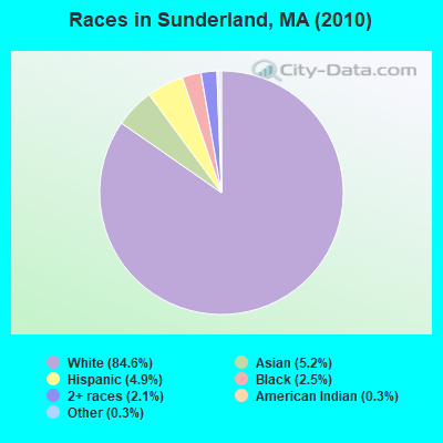
Races in Sunderland detailed stats: ancestries, foreign born residents, place of birth
According to our research of Massachusetts and other state lists, there were 4 registered sex offenders living in Sunderland, Massachusetts as of April 27, 2024.
The ratio of all residents to sex offenders in Sunderland is 921 to 1.
Type |
2009 |
2010 |
2016 |
2017 |
2018 |
2019 |
2020 |
2021 |
2022 |
|---|---|---|---|---|---|---|---|---|---|
| Murders (per 100,000) | 0 (0.0) | 0 (0.0) | 0 (0.0) | 0 (0.0) | 0 (0.0) | 0 (0.0) | 0 (0.0) | 0 (0.0) | 0 (0.0) |
| Rapes (per 100,000) | 0 (0.0) | 0 (0.0) | 1 (27.4) | 2 (55.1) | 0 (0.0) | 2 (54.7) | 2 (55.2) | 7 (192.9) | 0 (0.0) |
| Robberies (per 100,000) | 1 (26.6) | 0 (0.0) | 0 (0.0) | 2 (55.1) | 1 (27.5) | 0 (0.0) | 0 (0.0) | 0 (0.0) | 1 (27.4) |
| Assaults (per 100,000) | 10 (266.4) | 2 (54.3) | 5 (136.9) | 2 (55.1) | 3 (82.5) | 2 (54.7) | 6 (165.7) | 3 (82.7) | 3 (82.1) |
| Burglaries (per 100,000) | 10 (266.4) | 3 (81.4) | 11 (301.2) | 10 (275.7) | 4 (110.0) | 5 (136.8) | 3 (82.8) | 3 (82.7) | 2 (54.7) |
| Thefts (per 100,000) | 18 (479.5) | 8 (217.2) | 11 (301.2) | 15 (413.6) | 18 (494.8) | 13 (355.6) | 7 (193.3) | 15 (413.5) | 23 (629.3) |
| Auto thefts (per 100,000) | 0 (0.0) | 3 (81.4) | 2 (54.8) | 2 (55.1) | 1 (27.5) | 3 (82.1) | 1 (27.6) | 0 (0.0) | 1 (27.4) |
| Arson (per 100,000) | 0 (0.0) | 1 (27.1) | 0 (0.0) | 0 (0.0) | 0 (0.0) | 0 (0.0) | 0 (0.0) | 0 (0.0) | 0 (0.0) |
| City-Data.com crime index | 99.1 | 31.8 | 86.8 | 111.9 | 54.4 | 85.1 | 93.0 | 193.2 | 55.8 |
The City-Data.com crime index weighs serious crimes and violent crimes more heavily. Higher means more crime, U.S. average is 246.1. It adjusts for the number of visitors and daily workers commuting into cities.
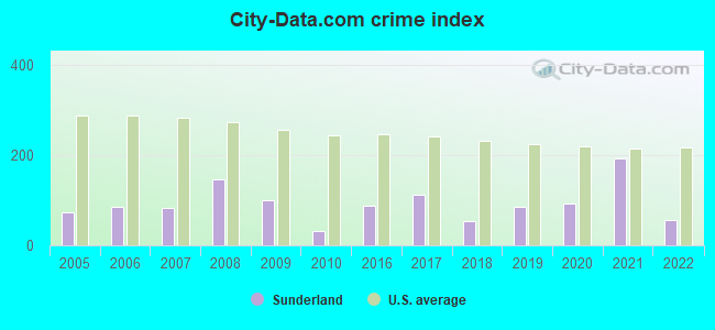
Crime rate in Sunderland detailed stats: murders, rapes, robberies, assaults, burglaries, thefts, arson
Full-time law enforcement employees in 2021, including police officers: 6 (5 officers - 4 male; 1 female).
| Officers per 1,000 residents here: | 1.38 |
| Massachusetts average: | 2.53 |
 Recent articles from our blog. Our writers, many of them Ph.D. graduates or candidates, create easy-to-read articles on a wide variety of topics.

 | Springfield to Boston rail (229 replies) |
| East west rail looks to be more of a reality (28 replies) |
| UMass Boston vs. UMass Amherst (104 replies) |
| Is Western Mass that bad? (104 replies) |
| So how *do* grad students find housing around Northampton??? (13 replies) |
| Pioneer Valley: Wood Stoves + Well/Spring Water? (31 replies) |
Latest news from Sunderland, MA collected exclusively by city-data.com from local newspapers, TV, and radio stations
Ancestries: Polish (17.3%), Irish (14.7%), English (12.6%), French (11.8%), German (9.2%), Italian (9.2%).
Current Local Time: EST time zone
Incorporated in 1714
Land area: 14.4 square miles.
Population density: 256 people per square mile (very low).
402 residents are foreign born (6.5% Asia, 1.7% Latin America, 1.5% Europe).
| This town: | 10.6% |
| Massachusetts: | 12.2% |
| Sunderland town: | 1.5% ($2,495) |
| Massachusetts: | 1.3% ($2,336) |
Nearest city with pop. 50,000+: Chicopee, MA  (20.1 miles , pop. 54,653).
Nearest city with pop. 200,000+: Boston, MA (75.9 miles , pop. 589,141).
Nearest city with pop. 1,000,000+: Bronx, NY (130.5 miles , pop. 1,332,650).
Nearest cities:
), ), Latitude: 42.46 N, Longitude: 72.56 W
Area code commonly used in this area: 413

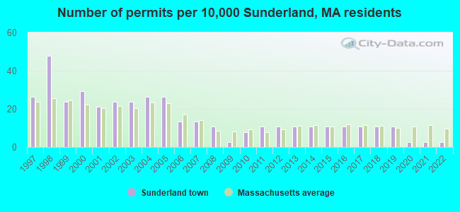
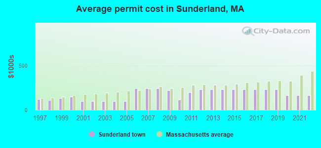
Single-family new house construction building permits:
- 2022: 1 building, cost: $166,500
- 2021: 1 building, cost: $166,500
- 2020: 1 building, cost: $166,500
- 2019: 4 buildings, average cost: $229,800
- 2018: 4 buildings, average cost: $229,800
- 2017: 4 buildings, average cost: $229,800
- 2016: 4 buildings, average cost: $229,800
- 2015: 4 buildings, average cost: $229,800
- 2014: 4 buildings, average cost: $229,800
- 2013: 4 buildings, average cost: $229,800
- 2012: 4 buildings, average cost: $229,800
- 2011: 4 buildings, average cost: $200,100
- 2010: 3 buildings, average cost: $116,700
- 2009: 1 building, cost: $222,000
- 2008: 4 buildings, average cost: $246,300
- 2007: 5 buildings, average cost: $246,300
- 2006: 5 buildings, average cost: $246,300
- 2005: 10 buildings, average cost: $97,800
- 2004: 10 buildings, average cost: $97,800
- 2003: 9 buildings, average cost: $97,800
- 2002: 9 buildings, average cost: $97,800
- 2001: 8 buildings, average cost: $97,800
- 2000: 11 buildings, average cost: $149,400
- 1999: 9 buildings, average cost: $129,900
- 1998: 18 buildings, average cost: $110,200
- 1997: 10 buildings, average cost: $124,100
| Here: | 2.4% |
| Massachusetts: | 3.5% |
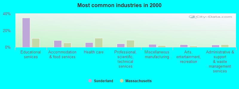
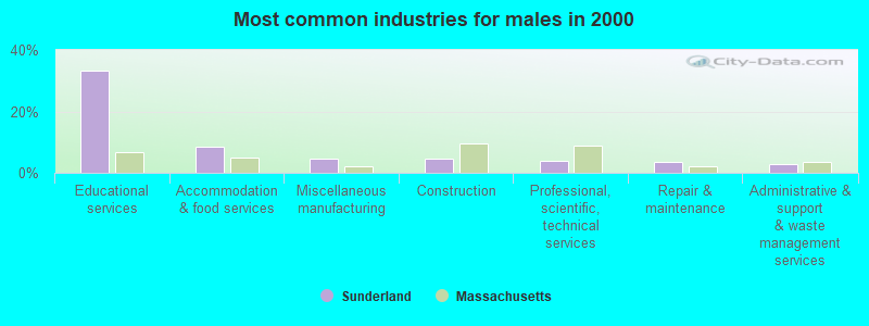
- Educational services (35.0%)
- Accommodation & food services (8.3%)
- Health care (5.7%)
- Professional, scientific, technical services (4.2%)
- Miscellaneous manufacturing (3.5%)
- Arts, entertainment, recreation (3.1%)
- Administrative & support & waste management services (2.9%)
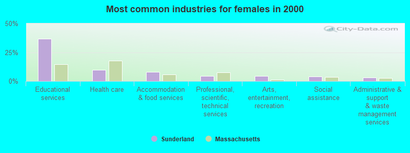
- Educational services (33.2%)
- Accommodation & food services (8.6%)
- Miscellaneous manufacturing (4.8%)
- Construction (4.7%)
- Professional, scientific, technical services (3.8%)
- Repair & maintenance (3.6%)
- Administrative & support & waste management services (2.9%)
- Educational services (36.6%)
- Health care (9.8%)
- Accommodation & food services (8.0%)
- Professional, scientific, technical services (4.5%)
- Arts, entertainment, recreation (4.4%)
- Social assistance (4.2%)
- Administrative & support & waste management services (2.9%)
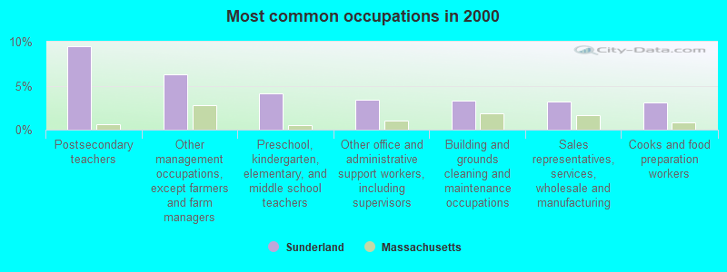
- Postsecondary teachers (9.5%)
- Other management occupations, except farmers and farm managers (6.3%)
- Preschool, kindergarten, elementary, and middle school teachers (4.2%)
- Other office and administrative support workers, including supervisors (3.4%)
- Building and grounds cleaning and maintenance occupations (3.3%)
- Sales representatives, services, wholesale and manufacturing (3.2%)
- Cooks and food preparation workers (3.1%)
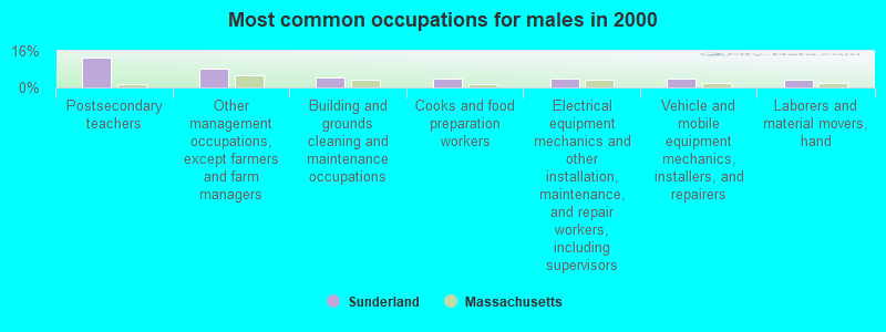
- Postsecondary teachers (13.0%)
- Other management occupations, except farmers and farm managers (8.2%)
- Building and grounds cleaning and maintenance occupations (4.4%)
- Cooks and food preparation workers (4.1%)
- Electrical equipment mechanics and other installation, maintenance, and repair workers, including supervisors (3.8%)
- Vehicle and mobile equipment mechanics, installers, and repairers (3.7%)
- Laborers and material movers, hand (3.3%)
- Postsecondary teachers (6.2%)
- Preschool, kindergarten, elementary, and middle school teachers (6.2%)
- Other office and administrative support workers, including supervisors (5.0%)
- Retail sales workers, except cashiers (4.9%)
- Other management occupations, except farmers and farm managers (4.5%)
- Food and beverage serving workers, except waiters and waitresses (4.1%)
- Waiters and waitresses (3.9%)
Average climate in Sunderland, Massachusetts
Based on data reported by over 4,000 weather stations


(lower is better)
Air Quality Index (AQI) level in 2022 was 74.4. This is about average.
| City: | 74.4 |
| U.S.: | 72.6 |
Carbon Monoxide (CO) [ppm] level in 2019 was 0.346. This is worse than average. Closest monitor was 18.9 miles away from the city center.
| City: | 0.346 |
| U.S.: | 0.251 |
Sulfur Dioxide (SO2) [ppb] level in 2022 was 0.193. This is significantly better than average. Closest monitor was 7.9 miles away from the city center.
| City: | 0.193 |
| U.S.: | 1.515 |
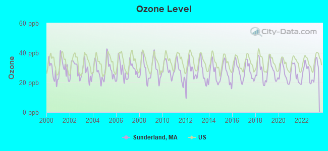
Ozone [ppb] level in 2022 was 26.8. This is better than average. Closest monitor was 4.6 miles away from the city center.
| City: | 26.8 |
| U.S.: | 33.3 |
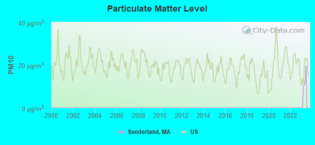
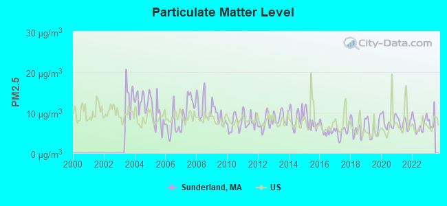
Particulate Matter (PM2.5) [µg/m3] level in 2022 was 7.03. This is about average. Closest monitor was 10.2 miles away from the city center.
| City: | 7.03 |
| U.S.: | 8.11 |
Tornado activity:
Sunderland-area historical tornado activity is above Massachusetts state average. It is 10% smaller than the overall U.S. average.
On 6/9/1953, a category F4 (max. wind speeds 207-260 mph) tornado 20.1 miles away from the Sunderland town center killed 90 people and injured 1228 people and caused between $50,000,000 and $500,000,000 in damages.
On 10/3/1979, a category F4 tornado 29.3 miles away from the town center killed 3 people and injured 500 people and caused between $50,000,000 and $500,000,000 in damages.
Earthquake activity:
Sunderland-area historical earthquake activity is significantly above Massachusetts state average. It is 70% smaller than the overall U.S. average.On 10/7/1983 at 10:18:46, a magnitude 5.3 (5.1 MB, 5.3 LG, 5.1 ML, Class: Moderate, Intensity: VI - VII) earthquake occurred 136.7 miles away from Sunderland center
On 4/20/2002 at 10:50:47, a magnitude 5.3 (5.3 ML, Depth: 3.0 mi) earthquake occurred 152.9 miles away from Sunderland center
On 4/20/2002 at 10:50:47, a magnitude 5.2 (5.2 MB, 4.2 MS, 5.2 MW, 5.0 MW) earthquake occurred 151.7 miles away from Sunderland center
On 1/19/1982 at 00:14:42, a magnitude 4.7 (4.5 MB, 4.7 MD, 4.5 LG, Class: Light, Intensity: IV - V) earthquake occurred 86.9 miles away from Sunderland center
On 10/16/2012 at 23:12:25, a magnitude 4.7 (4.7 ML, Depth: 10.0 mi) earthquake occurred 124.4 miles away from the city center
On 10/2/1994 at 11:27:22, a magnitude 3.7 (3.5 LG, 3.7 LG, Depth: 6.2 mi, Class: Light, Intensity: II - III) earthquake occurred 16.6 miles away from Sunderland center
Magnitude types: regional Lg-wave magnitude (LG), body-wave magnitude (MB), duration magnitude (MD), local magnitude (ML), surface-wave magnitude (MS), moment magnitude (MW)
Natural disasters:
The number of natural disasters in Franklin County (20) is greater than the US average (15).Major Disasters (Presidential) Declared: 9
Emergencies Declared: 10
Causes of natural disasters: Floods: 5, Storms: 5, Hurricanes: 4, Snowstorms: 4, Winter Storms: 3, Blizzards: 2, Snows: 2, Snowfall: 1, Tropical Storm: 1, Wind: 1, Other: 1 (Note: some incidents may be assigned to more than one category).
Hospitals and medical centers in Sunderland:
Other hospitals and medical centers near Sunderland:
- HOSPICE OF THE FISHER HOME (Hospital, about 4 miles away; AMHERST, MA)
- CENTER FOR EXTENDED CARE AT AMHERST (Nursing Home, about 7 miles away; AMHERST, MA)
- HADLEY AT ELAINE CARE AND REHABILITATION CENTER (Nursing Home, about 7 miles away; HADLEY, MA)
- BUCKLEY-GREENFIELD HEALTHCARE CENTER (Nursing Home, about 9 miles away; GREENFIELD, MA)
- GENTIVA HEALTH SERVICES (Home Health Center, about 9 miles away; GREENFIELD, MA)
- SERVICENET HOMECARE (Home Health Center, about 10 miles away; NORTHAMPTON, MA)
- HOME CARE PRN INC (Home Health Center, about 10 miles away; GREENFIELD, MA)
Colleges/universities with over 2000 students nearest to Sunderland:
- University of Massachusetts-Amherst (about 6 miles; Amherst, MA; Full-time enrollment: 26,583)
- Smith College (about 11 miles; Northampton, MA; FT enrollment: 3,549)
- Mount Holyoke College (about 15 miles; South Hadley, MA; FT enrollment: 2,573)
- Holyoke Community College (about 19 miles; Holyoke, MA; FT enrollment: 4,911)
- Western New England University (about 24 miles; Springfield, MA; FT enrollment: 3,477)
- American International College (about 25 miles; Springfield, MA; FT enrollment: 2,733)
- Springfield Technical Community College (about 25 miles; Springfield, MA; FT enrollment: 4,750)
Public elementary/middle school in Sunderland:
- SUNDERLAND ELEMENTARY (Students: 218, Location: 1 SWAMPFIELD DRIVE, Grades: PK-6)
User-submitted facts and corrections:
- Library in Sunderland: Sunderland Public Library, 20 School Street; 413-665-2642; Open 40 hours per week; FY2006 Operating Income: $125,562; FY2005 Annual Circulation: 55,968 items; FY2005 Attendance in Library: 47,052 patrons; FY2005 Holdings Information: 23,126 books; 1,312 audios; 2,497 videos; 83 magazine subscriptions.
- Sunderland Amateur Radio Communications: 53.350 - PL 71.9 145.130 - PL 173.8 442.200 + PL 173.8 443.450 + PL 173.8 Used for Emergency Communications, Skywarn (weather related situations and goodwill among the community.
Points of interest:
Notable locations in Sunderland: Massachusetts State Fish Hatchery (A), Sunderland Fire Department (B), Graves Memorial Library (C). Display/hide their locations on the map
Cemeteries: Riverside Cemetery (1), North Sunderland Cemetery (2). Display/hide their locations on the map
Lakes, reservoirs, and swamps: Chard Pond (A), Whitmore Pond (B), Cranberry Pond (C), Greene Swamp (D). Display/hide their locations on the map
Streams, rivers, and creeks: Gunn Brook (A), Mohawk Brook (B), Dry Brook (C), Long Plain Brook (D), Great Drain (E). Display/hide their locations on the map
Drinking water stations with addresses in Sunderland and their reported violations in the past:
CLIFFSIDE APARTMENTS (Population served: 550, Groundwater):Past monitoring violations:POND RIDGE CONDO ASSN (Address: 370-E. MONTAGUE RD , Population served: 88, Groundwater):
- Follow-up Or Routine LCR Tap M/R - In JUN-01-2012, Contaminant: Lead and Copper Rule. Follow-up actions: St AO (w/o penalty) issued (NOV-19-2012)
- 2 regular monitoring violations
Past health violations:Past monitoring violations:
- MCL, Monthly (TCR) - In NOV-2013, Contaminant: Coliform. Follow-up actions: St AO (w/o penalty) issued (DEC-13-2013)
- MCL, Monthly (TCR) - In AUG-2012, Contaminant: Coliform. Follow-up actions: St AO (w/o penalty) issued (AUG-06-2012)
- MCL, Monthly (TCR) - In OCT-2009, Contaminant: Coliform. Follow-up actions: St AO (w/o penalty) issued (NOV-04-2009)
- Monitoring and Reporting (DBP) - In AUG-01-2013, Contaminant: DBP Stage 1. Follow-up actions: St AO (w/o penalty) issued (OCT-23-2013)
- Follow-up Or Routine LCR Tap M/R - In JAN-01-2013, Contaminant: Lead and Copper Rule. Follow-up actions: St AO (w/o penalty) issued (2 times from FEB-14-2014 to FEB-26-2014)
- One minor monitoring violation
- 26 regular monitoring violations
Drinking water stations with addresses in Sunderland that have no violations reported:
- SUNDERLAND WATER DISTRICT (Population served: 2,990, Primary Water Source Type: Groundwater)
| This town: | 2.2 people |
| Massachusetts: | 2.5 people |
| This town: | 46.1% |
| Whole state: | 63.0% |
| This town: | 12.3% |
| Whole state: | 7.0% |
Likely homosexual households (counted as self-reported same-sex unmarried-partner households)
- Lesbian couples: 1.4% of all households
- Gay men: 0.6% of all households
| This town: | 14.0% |
| Whole state: | 9.3% |
| This town: | 7.2% |
| Whole state: | 4.4% |
6 people in group homes intended for adults in 2010
46 people in nursing homes in 2000
6 people in homes for the mentally ill in 2000
Banks with branches in Sunderland (2011 data):
- Greenfield Co-operative Bank: Sunderland Branch at 18 Amherst Road, branch established on 2003/01/06. Info updated 2008/12/09: Bank assets: $308.4 mil, Deposits: $260.0 mil, headquarters in Greenfield, MA, positive income, Mortgage Lending Specialization, 5 total offices, Holding Company: Greenfield Bancorp Mhc
For population 15 years and over in Sunderland:
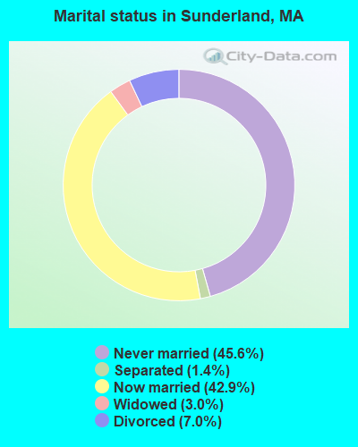
- Never married: 45.6%
- Now married: 42.9%
- Separated: 1.4%
- Widowed: 3.0%
- Divorced: 7.0%
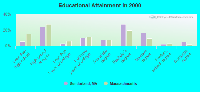
For population 25 years and over in Sunderland:
- High school or higher: 94.4%
- Bachelor's degree or higher: 50.5%
- Graduate or professional degree: 23.2%
- Unemployed: 4.7%
- Mean travel time to work (commute): 20.2 minutes
| Here: | 10.8 |
| Massachusetts average: | 13.1 |


Graphs represent county-level data. Detailed 2008 Election Results
Religion statistics for Sunderland, MA (based on Franklin County data)


| Religion | Adherents | Congregations |
|---|---|---|
| Catholic | 16,509 | 15 |
| Mainline Protestant | 4,617 | 38 |
| Evangelical Protestant | 2,079 | 20 |
| Other | 1,580 | 21 |
| None | 46,587 | - |
Food Environment Statistics:
| This county: | 3.63 / 10,000 pop. |
| State: | 1.98 / 10,000 pop. |
| Franklin County: | 0.14 / 10,000 pop. |
| State: | 0.05 / 10,000 pop. |
| Franklin County: | 1.67 / 10,000 pop. |
| State: | 2.22 / 10,000 pop. |
| Here: | 3.21 / 10,000 pop. |
| State: | 1.77 / 10,000 pop. |
| Franklin County: | 8.10 / 10,000 pop. |
| Massachusetts: | 8.76 / 10,000 pop. |
| This county: | 7.5% |
| Massachusetts: | 8.1% |
| This county: | 22.2% |
| Massachusetts: | 22.5% |
| Here: | 15.1% |
| Massachusetts: | 16.5% |
| Businesses in Sunderland, MA | ||||
| Name | Count | Name | Count | |
|---|---|---|---|---|
| 7-Eleven | 2 | Subway | 1 | |
| Dunkin Donuts | 1 | U-Haul | 1 | |
Strongest AM radio stations in Sunderland:
- WNNZ (640 AM; 50 kW; WESTFIELD, MA; Owner: CLEAR CHANNEL BROADCASTING LICENSES, INC.)
- WIZZ (1520 AM; daytime; 10 kW; GREENFIELD, MA; Owner: P. & M. RADIO, LLC)
- WPNI (1430 AM; 5 kW; AMHERST, MA; Owner: WESTERN MASSACHUSETTS RADIO COMPANY)
- WCRN (830 AM; 50 kW; WORCESTER, MA; Owner: CARTER BROADCASTING CORPORATION)
- WVNE (760 AM; daytime; 25 kW; LEICESTER, MA; Owner: BLOUNT MASSCOM, INC.)
- WHYN (560 AM; 5 kW; SPRINGFIELD, MA; Owner: CLEAR CHANNEL BROADCASTING LICENSES, INC.)
- WTIC (1080 AM; 50 kW; HARTFORD, CT; Owner: INFINITY RADIO OPERATIONS INC.)
- WACE (730 AM; 5 kW; CHICOPEE, MA; Owner: CARTER BROADCASTING CORP.)
- WRKO (680 AM; 50 kW; BOSTON, MA; Owner: ENTERCOM BOSTON LICENSE, LLC)
- WALE (990 AM; 50 kW; GREENVILLE, RI; Owner: NORTH AMERICAN BROADCASTING CO., INC.)
- WEEI (850 AM; 50 kW; BOSTON, MA; Owner: ENTERCOM BOSTON LICENSE, LLC)
- WCAT (700 AM; daytime; 2 kW; ORANGE-ATHOL, MA; Owner: CITADEL BROADCASTING COMPANY)
- WKOX (1200 AM; 50 kW; FRAMINGHAM, MA; Owner: CAPSTAR TX LIMITED PARTNERSHIP)
Strongest FM radio stations in Sunderland:
- WFCR (88.5 FM; AMHERST, MA; Owner: UNIVERSITY OF MASSACHUSETTS)
- WAMH (89.3 FM; AMHERST, MA; Owner: TRUSTEES OF AMHERST COLLEGE)
- WGAJ (91.7 FM; DEERFIELD, MA; Owner: TRUATEES OF DEERFIELD ACADEMY)
- W246AM (97.1 FM; AMHERST, MA; Owner: GREAT NORTHERN RADIO, LLC)
- WHYN-FM (93.1 FM; SPRINGFIELD, MA; Owner: CLEAR CHANNEL BROADCASTING LICENSES, INC.)
- WLZX (99.3 FM; NORTHAMPTON, MA; Owner: SAGA COMMUNICATIONS OF NEW ENGLAND, LLC)
- WHAI (98.3 FM; GREENFIELD, MA; Owner: SAGA COMMUNICATIONS OF NEW ENGLAND, LLC)
- WRNX (100.9 FM; AMHERST, MA; Owner: WESTERN MASSACHUSETTS RADIO COMPANY)
- WRSI (93.9 FM; TURNERS FALLS, MA; Owner: GREAT NORTHERN RADIO, LLC)
- WPVQ (95.3 FM; GREENFIELD, MA; Owner: GREAT NORTHERN RADIO, L.L.C.)
- WAMC-FM (90.3 FM; ALBANY, NY; Owner: WAMC)
- WEIB (106.3 FM; NORTHAMPTON, MA; Owner: CUTTING EDGE BROADCASTING, INC.)
- WMUA (91.1 FM; AMHERST, MA; Owner: UNIVERSITY OF MASSACHUSETTS)
- WEQX (102.7 FM; MANCHESTER, VT; Owner: NORTHSHIRE COMMUNICATIONS, INC.)
- WVAY (100.7 FM; WILMINGTON, VT; Owner: GREAT NORTHERN RADIO, L.L.C.)
- WJAN (95.1 FM; SUNDERLAND, VT; Owner: 6 JOHNSON ROAD LICENSES, INC.)
- WYRY (104.9 FM; HINSDALE, NH; Owner: TRI-VALLEY BROADCASTING CORPORATION)
- WAQY (102.1 FM; SPRINGFIELD, MA; Owner: SAGA COMMUNICATIONS OF NEW ENGLAND, LLC)
- WAAF (107.3 FM; WORCESTER, MA; Owner: ENTERCOM BOSTON LICENSE, LLC)
- WRSY (101.5 FM; MARLBORO, VT; Owner: GREAT NORTHERN RADIO, L.L.C.)
TV broadcast stations around Sunderland:
- WYDN (Channel 48; WORCESTER, MA; Owner: EDUCATIONAL PUBLIC TV CORPORATION)
- WUNI (Channel 27; WORCESTER, MA; Owner: ENTRAVISION HOLDINGS, LLC)
- WTIC-TV (Channel 61; HARTFORD, CT; Owner: TRIBUNE TELEVISION COMPANY)
- WWLP (Channel 22; SPRINGFIELD, MA; Owner: WWLP BROADCASTING, LLC)
- W67DF (Channel 67; SPRINGFIELD, MA; Owner: TRINITY BROADCASTING NETWORK)
- W35BK (Channel 35; PLAINFIELD, MA; Owner: LYDIA SYLVANE STOCKWELL)
- WGGB-TV (Channel 40; SPRINGFIELD, MA; Owner: WGGB LICENSEE, LLC)
- WGBY-TV (Channel 57; SPRINGFIELD, MA; Owner: WGBH EDUCATIONAL FOUNDATION)
- National Bridge Inventory (NBI) Statistics
- 1Number of bridges
- 3ft / 0.8mTotal length
- $667,000Total costs
- 13,876Total average daily traffic
- 1,248Total average daily truck traffic
- 22,742Total future (year 2031) average daily traffic
FCC Registered Antenna Towers:
9 (See the full list of FCC Registered Antenna Towers in Sunderland)FCC Registered Broadcast Land Mobile Towers:
1- Fire Headquarters N Main St (Lat: 42.466750 Lon: -72.574528), Call Sign: KCN366, Licensee ID: L00566908,
Assigned Frequencies: 33.5400 MHz, Grant Date: 05/05/2005, Expiration Date: 08/01/2015, Cancellation Date: 10/03/2015, Registrant: Sunderland, Town Of, 12 School St, Sunderland, MA 01375, Phone: (413) 665-2465, Fax: (413) 665-7599
FCC Registered Microwave Towers:
6- STATION, Dem Fire Tower Mt Toby (Lat: 42.487861 Lon: -72.537861), Structure height: 18.3 m, Call Sign: WNEK364,
Assigned Frequencies: 952.337 MHz, 928.337 MHz, Grant Date: 10/01/1998, Expiration Date: 12/30/2008, Cancellation Date: 03/07/2009, Phone: (617) 849-5503
- MT TOBY, Mt Toby State Forest (Lat: 42.488083 Lon: -72.537611), Type: Mast, Structure height: 17 m, Overall height: 18 m, Call Sign: WPRW658,
Assigned Frequencies: 933.175 MHz, Grant Date: 12/24/2020, Expiration Date: 03/02/2031, Certifier: Richard P Hanlon, Registrant: Massachusetts, Commonwealth Of, 470 Worcester Rd, Framingham, MA 01702, Phone: (774) 462-3767, Email:
- MOUNT TOBY, Top Of Mt Toby (Lat: 42.488000 Lon: -72.538083), Type: Tower, Structure height: 30.4 m, Overall height: 33.5 m, Call Sign: WQDJ213,
Assigned Frequencies: 955.150 MHz, Grant Date: 09/08/2005, Expiration Date: 09/08/2015, Cancellation Date: 11/14/2015, Certifier: Russell Sienkiewcz, Registrant: New England Communications Systems, Inc, 15 Industrial Park Place, Middletown, CT 06457, Phone: (860) 632-2678, Fax: (860) 613-0559, Email:
- TOBY MTN, Toby State Forest (Lat: 42.488139 Lon: -72.537583), Type: Mast, Structure height: 21 m, Call Sign: WQDR569,
Assigned Frequencies: 10638.7 MHz, Grant Date: 07/21/2015, Expiration Date: 10/13/2025, Certifier: Linda Dunlavy, Registrant: Franklin Regional Council Of Governments, 12 Olive St Ste 2, Greenfield, MA 01301-3351, Phone: (413) 774-3167, Fax: (413) 774-3169, Email:
- MT TOBY, Mt Toby State Forest (Lat: 42.488083 Lon: -72.537611), Type: Mast, Structure height: 21.6 m, Call Sign: WQNC870,
Assigned Frequencies: 10975.0 MHz, 6315.84 MHz, 10648.1 MHz, Grant Date: 09/29/2020, Expiration Date: 12/21/2030, Certifier: Charles B Sutherland, Registrant: Massachusetts, Commonwealth Of, 470 Worcester Rd, Framingham, MA 01702, Phone: (508) 820-2264, Email:
- STATION, D E Q E Fire Tower Mt Toby (Lat: 42.488139 Lon: -72.537861), Structure height: 18.3 m, Call Sign: WBH350,
Assigned Frequencies: 953.200 MHz, 957.200 MHz, Grant Date: 09/22/2020, Expiration Date: 11/21/2030, Registrant: Massachusetts Department Of Transportation- Highway, 10 Park Plaza - Suite 7410, Boston, MA 02116, Phone: (617) 835-6922, Email:
FCC Registered Amateur Radio Licenses:
22 (See the full list of FCC Registered Amateur Radio Licenses in Sunderland)FAA Registered Aircraft:
3- Aircraft: CESSNA 150H (Category: Land, Seats: 2, Weight: Up to 12,499 Pounds, Speed: 90 mph), Engine: CONT MOTOR 0-200 SERIES (100 HP) (Reciprocating)
N-Number: 22060, N22060, N-22060, Serial Number: 15068036, Airworthiness Date: 02/28/1968, Certificate Issue Date: 06/24/2019
Registrant (Individual): Thomas G Watson, 60 Old Amherst Rd, Sunderland, MA 01375
Deregistered: Cancel Date: 04/19/2018 - Aircraft: SCHLAPPI DALE VANS RV8 (Category: Land, Seats: 2, Weight: Up to 12,499 Pounds), Engine: LYCOMING 0-320 SERIES (180 HP) (Reciprocating)
N-Number: 8XF, N8XF, N-8XF, Serial Number: 81979, Year manufactured: 2005, Airworthiness Date: 09/16/2005, Certificate Issue Date: 07/27/2004
Registrant (Individual): Dale D Schlappi, 324 Falls Rd, Sunderland, MA 01375 - Aircraft: BALLOON WORKS FIREFLY 7 (Category: Land, Weight: Up to 12,499 Pounds, Speed: 63 mph), Engine: None
N-Number: 9062B, N9062B, N-9062B, Serial Number: F7-613, Airworthiness Date: 10/17/1989, Certificate Issue Date: 07/29/2002
Registrant (Individual): Roger D Morin, 133 N Main St, Sunderland, MA 01375
Deregistered: Cancel Date: 06/15/2017
2002 - 2018 National Fire Incident Reporting System (NFIRS) incidents
- Fire incident types reported to NFIRS in Sunderland, MA
- 19059.6%Structure Fires
- 9028.2%Outside Fires
- 226.9%Mobile Property/Vehicle Fires
- 175.3%Other
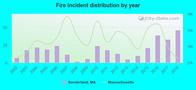 According to the data from the years 2002 - 2018 the average number of fires per year is 19. The highest number of fires - 46 took place in 2018, and the least - 2 in 2008. The data has a growing trend.
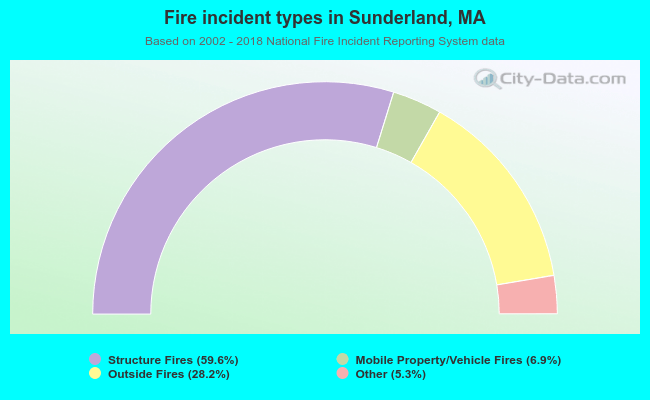 When looking into fire subcategories, the most reports belonged to: Structure Fires (59.6%), and Outside Fires (28.2%).
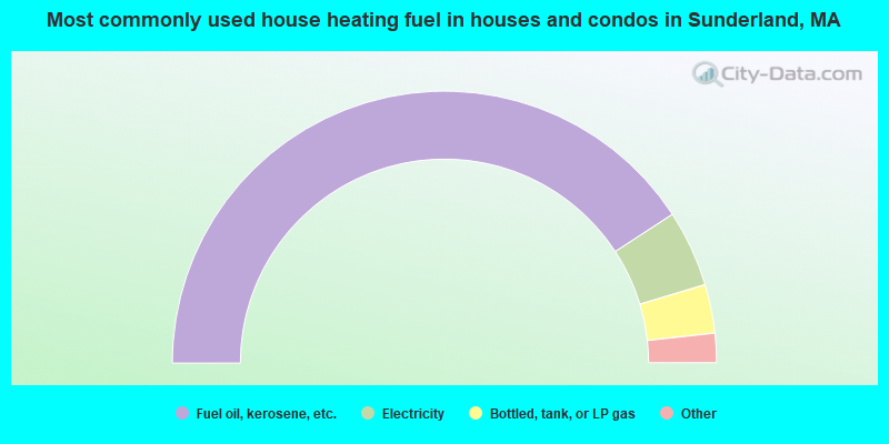
- 81.6%Fuel oil, kerosene, etc.
- 9.1%Electricity
- 5.8%Bottled, tank, or LP gas
- 2.2%Wood
- 1.2%Utility gas
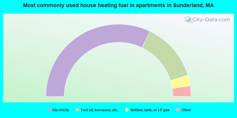
- 64.2%Electricity
- 26.2%Fuel oil, kerosene, etc.
- 4.8%Bottled, tank, or LP gas
- 3.1%Utility gas
- 0.9%Other fuel
- 0.8%Wood
Sunderland compared to Massachusetts state average:
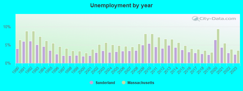
- Unemployed percentage significantly below state average.
- Black race population percentage below state average.
- Hispanic race population percentage below state average.
- Median age significantly below state average.
- Foreign-born population percentage below state average.
- Length of stay since moving in significantly above state average.
- Number of rooms per house significantly below state average.
- House age significantly below state average.
- Number of college students above state average.
- Percentage of population with a bachelor's degree or higher above state average.

|
|
Total of 120 patent applications in 2008-2024.