Deerfield, Massachusetts
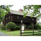
Deerfield: Historic Deerfield
Deerfield: Historic Deerfield
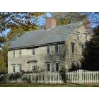
Deerfield: Barnard Tavern, Old Deerfield
Deerfield: Memorial Street, Old Deerfield
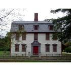
Deerfield: Historic Deerfield
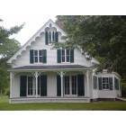
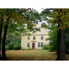
Deerfield: Moors House, Old Deerfield
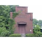
Deerfield: Old Deerfield, MA
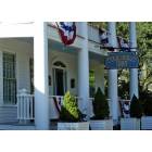
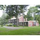
Deerfield: Deerfield Inn, Old Deerfield, MA
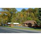
Deerfield: Deerfield, MA roadside farm stand
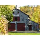
Deerfield: Deerfield, MA country barn

Deerfield: Deerfield
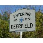
Deerfield: Entering Deerfield, MA
- add
your
Submit your own pictures of this town and show them to the world
- OSM Map
- General Map
- Google Map
- MSN Map

Population change since 2000: +7.9%
 |
| Males: 2,508 | |
| Females: 2,617 |
| Median resident age: | 45.1 years |
| Massachusetts median age: | 39.2 years |
Zip codes: 01342.
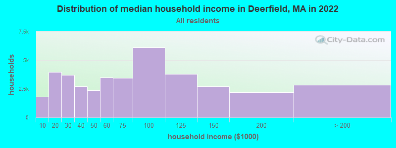
| Deerfield: | $85,820 |
| MA: | $94,488 |
Estimated per capita income in 2022: $44,738 (it was $24,555 in 2000)
Deerfield town income, earnings, and wages data
Estimated median house or condo value in 2022: $378,243 (it was $152,200 in 2000)
| Deerfield: | $378,243 |
| MA: | $534,700 |
Mean prices in 2022: all housing units: $313,377; detached houses: $324,224; townhouses or other attached units: $284,225; in 2-unit structures: $287,978; in 3-to-4-unit structures: $183,938; in 5-or-more-unit structures: $249,762; mobile homes: $62,200
Detailed information about poverty and poor residents in Deerfield, MA
Compare current foreclosures near Deerfield, MA:
| Photo | Address | Area | Beds / Baths | Price | Details |
|---|---|---|---|---|---|

|
#1
Lampblack Rd
Greenfield, MA 01301
|
2,078 sq. feet
|
1 baths 3 beds |
$379,900
|
show details |

|
#2
South St
Ashfield, MA 01330
|
4,386 sq. feet
|
3 baths 6 beds |
show details | |

|
#3
Dewey Cir # 5a
Haydenville, MA 01039
|
800 sq. feet
|
2 baths 3 beds |
show details | |

|
#4
West St
Greenfield, MA 01301
|
1,858 sq. feet
|
2 baths 3 beds |
show details | |

|
#5
Chapman St
Greenfield, MA 01301
|
- sq. feet
|
1 baths 3 beds |
show details | |

|
#6
Myrtle St # 1
Northampton, MA 01060
|
2,222 sq. feet
|
2 baths 4 beds |
show details | |

|
#7
Chestnut St
West Hatfield, MA 01088
|
1,248 sq. feet
|
1 baths 3 beds |
show details | |

|
#8
North St
Hatfield, MA 01038
|
1,900 sq. feet
|
1 baths 3 beds |
show details | |

|
#9
Braeburn Rd
South Deerfield, MA 01373
|
1,661 sq. feet
|
1 baths 3 beds |
show details | |

|
#10
Bridge St # 1
Hatfield, MA 01038
|
3,300 sq. feet
|
3 baths 4 beds |
show details |
| Photo | Address | Area | Beds / Baths | Price | Details |
|---|---|---|---|---|---|

|
#11
Boyle Rd
Northfield, MA 01354
|
1,500 sq. feet
|
2 baths 3 beds |
show details | |

|
#12
Bald Mountain Rd
Bernardston, MA 01337
|
918 sq. feet
|
1 baths 2 beds |
show details | |

|
#13
Bedford Ct
Amherst, MA 01002
|
912 sq. feet
|
1 baths 2 beds |
show details | |

|
#14
Shays St # 1
Amherst, MA 01002
|
925 sq. feet
|
2 baths 3 beds |
show details | |

|
#15
Kosior Dr
Hadley, MA 01035
|
1,040 sq. feet
|
1 baths 2 beds |
show details | |

|
#16
Wildflower Dr
Amherst, MA 01002
|
2,330 sq. feet
|
2 baths 4 beds |
show details | |

|
#17
New Plain Rd
Northfield, MA 01360
|
2,370 sq. feet
|
2 baths 2 beds |
show details | |

|
#18
Purington Ln
Colrain, MA 01340
|
2,030 sq. feet
|
1 baths 5 beds |
show details | |

|
#19
Pine St
Amherst, MA 01002
|
2,195 sq. feet
|
2 baths 4 beds |
show details | |

|
#20
W Main St
New Salem, MA 01355
|
4,624 sq. feet
|
3 baths 6 beds |
show details |
| Photo | Address | Area | Beds / Baths | Price | Details |
|---|---|---|---|---|---|

|
#21
Chesterfield Rd
Easthampton, MA 01027
|
3,977 sq. feet
|
2 baths 6 beds |
show details | |

|
#22
Brierwood Dr
Florence, MA 01062
|
960 sq. feet
|
1 baths 3 beds |
show details | |

|
#23
North St
Belchertown, MA 01007
|
1,924 sq. feet
|
2 baths 3 beds |
show details | |

|
#24
Bay Rd
Amherst, MA 01002
|
1,671 sq. feet
|
1 baths 4 beds |
show details | |

|
#25
Lake Mattawa Rd
Orange, MA 01364
|
1,666 sq. feet
|
1 baths 3 beds |
show details | |

|
#26
Hulst Rd
Amherst, MA 01002
|
3,138 sq. feet
|
3 baths 4 beds |
show details | |

|
#27
Main St
Northfield, MA 01360
|
6,076 sq. feet
|
2 baths 9 beds |
show details | |

|
#28
Maynard St
Orange, MA 01364
|
1,640 sq. feet
|
2 baths 3 beds |
show details | |

|
#29
Tea St
Charlemont, MA 01339
|
2,829 sq. feet
|
2 baths 6 beds |
show details | |

|
#30
E River St
Orange, MA 01364
|
1,332 sq. feet
|
1 baths 3 beds |
show details |
| Photo | Address | Area | Beds / Baths | Price | Details |
|---|---|---|---|---|---|

|
#31
Log Plain Rd
Greenfield, MA 01301
|
960 sq. feet
|
1 baths 3 beds |
show details | |

|
#32
N Main St
South Deerfield, MA 01373
|
2,143 sq. feet
|
1 baths 5 beds |
show details | |

|
#33
Sand Hill Rd
Amherst, MA 01002
|
2,037 sq. feet
|
3 baths 5 beds |
show details | |

|
#34
Grove St
Turners Falls, MA 01376
|
2,273 sq. feet
|
1 baths 4 beds |
show details | |

|
#35
Sunderland Rd
South Deerfield, MA 01373
|
1,385 sq. feet
|
1 baths 3 beds |
show details | |

|
#36
Meridian St
Greenfield, MA 01301
|
768 sq. feet
|
1 baths 2 beds |
show details | |

|
#37
Deerfield St
Greenfield, MA 01301
|
1,496 sq. feet
|
2 baths 3 beds |
show details | |

|
#38
Hope St
Greenfield, MA 01301
|
1,619 sq. feet
|
1 baths 3 beds |
show details | |

|
#39
James St
Greenfield, MA 01301
|
2,176 sq. feet
|
2 baths 4 beds |
show details | |

|
#40
Maple St
Greenfield, MA 01301
|
1,216 sq. feet
|
1 baths 3 beds |
show details |
| Photo | Address | Area | Beds / Baths | Price | Details |
|---|---|---|---|---|---|

|
#41
Garfield St
Greenfield, MA 01301
|
2,260 sq. feet
|
2 baths 4 beds |
show details | |

|
#42
Elm St
Greenfield, MA 01301
|
1,160 sq. feet
|
1 baths 3 beds |
show details | |

|
#43
Forest Ave
Greenfield, MA 01301
|
1,764 sq. feet
|
1 baths 4 beds |
show details | |

|
#44
Dell St
Turners Falls, MA 01376
|
720 sq. feet
|
1 baths 1 beds |
show details | |

|
#45
Chapman St
Greenfield, MA 01301
|
1,472 sq. feet
|
1 baths 2 beds |
show details | |

|
#46
Long Plain Rd
South Deerfield, MA 01373
|
1,909 sq. feet
|
2 baths 4 beds |
show details | |

|
#47
French King Hwy
Greenfield, MA 01301
|
1,040 sq. feet
|
1 baths 5 beds |
show details | |

|
#48
Sabans Rd
Conway, MA 01341
|
1,246 sq. feet
|
1 baths 3 beds |
show details | |

|
#49
Eddy St
Orange, MA 01364
|
1,116 sq. feet
|
1 baths 2 beds |
show details | |

|
Check over 1 million property listings on Foreclosure.com!
|
browse all offers | |||


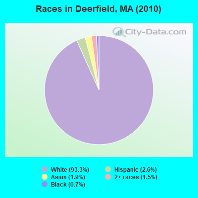
- 4,78193.3%White alone
- 1322.6%Hispanic
- 961.9%Asian alone
- 771.5%Two or more races
- 340.7%Black alone
- 30.06%Other race alone
- 10.02%American Indian alone
- 10.02%Native Hawaiian and Other
Pacific Islander alone
Races in Deerfield detailed stats: ancestries, foreign born residents, place of birth
According to our research of Massachusetts and other state lists, there was 1 registered sex offender living in Deerfield, Massachusetts as of April 27, 2024.
The ratio of all residents to sex offenders in Deerfield is 5,125 to 1.
The ratio of registered sex offenders to all residents in this city is much lower than the state average.
Type |
2009 |
2010 |
2011 |
2012 |
2013 |
2014 |
2015 |
2016 |
2017 |
2018 |
2019 |
2020 |
2021 |
2022 |
|---|---|---|---|---|---|---|---|---|---|---|---|---|---|---|
| Murders (per 100,000) | 0 (0.0) | 0 (0.0) | 0 (0.0) | 0 (0.0) | 0 (0.0) | 0 (0.0) | 0 (0.0) | 0 (0.0) | 0 (0.0) | 0 (0.0) | 0 (0.0) | 0 (0.0) | 0 (0.0) | 0 (0.0) |
| Rapes (per 100,000) | 2 (41.8) | 0 (0.0) | 0 (0.0) | 0 (0.0) | 0 (0.0) | 1 (19.7) | 3 (59.6) | 1 (20.0) | 0 (0.0) | 1 (20.0) | 2 (39.7) | 2 (40.2) | 1 (19.8) | 2 (38.8) |
| Robberies (per 100,000) | 0 (0.0) | 1 (19.5) | 1 (19.4) | 0 (0.0) | 2 (39.1) | 1 (19.7) | 1 (19.9) | 0 (0.0) | 0 (0.0) | 1 (20.0) | 0 (0.0) | 1 (20.1) | 0 (0.0) | 0 (0.0) |
| Assaults (per 100,000) | 15 (313.8) | 8 (156.1) | 12 (232.7) | 8 (154.3) | 5 (97.7) | 17 (334.6) | 7 (139.0) | 5 (100.1) | 11 (221.3) | 5 (99.8) | 3 (59.6) | 4 (80.4) | 10 (198.4) | 4 (77.6) |
| Burglaries (per 100,000) | 38 (795.0) | 41 (800.0) | 49 (950.3) | 38 (732.7) | 16 (312.5) | 19 (374.0) | 16 (317.6) | 6 (120.1) | 11 (221.3) | 12 (239.4) | 15 (298.1) | 3 (60.3) | 8 (158.7) | 4 (77.6) |
| Thefts (per 100,000) | 71 (1,485) | 68 (1,327) | 50 (969.7) | 44 (848.4) | 67 (1,309) | 37 (728.3) | 48 (952.9) | 47 (941.1) | 41 (824.8) | 41 (818.0) | 27 (536.6) | 20 (401.9) | 20 (396.7) | 23 (446.3) |
| Auto thefts (per 100,000) | 0 (0.0) | 5 (97.6) | 1 (19.4) | 3 (57.8) | 3 (58.6) | 2 (39.4) | 2 (39.7) | 2 (40.0) | 0 (0.0) | 6 (119.7) | 1 (19.9) | 1 (20.1) | 0 (0.0) | 2 (38.8) |
| Arson (per 100,000) | 1 (20.9) | 0 (0.0) | 0 (0.0) | 0 (0.0) | 0 (0.0) | 1 (19.7) | 1 (19.9) | 1 (20.0) | 0 (0.0) | 0 (0.0) | 1 (19.9) | 0 (0.0) | 0 (0.0) | 0 (0.0) |
| City-Data.com crime index | 211.3 | 154.0 | 159.2 | 120.7 | 110.2 | 147.0 | 144.9 | 85.3 | 92.7 | 101.0 | 87.6 | 76.2 | 82.5 | 73.0 |
The City-Data.com crime index weighs serious crimes and violent crimes more heavily. Higher means more crime, U.S. average is 246.1. It adjusts for the number of visitors and daily workers commuting into cities.

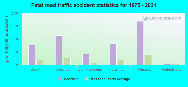
Crime rate in Deerfield detailed stats: murders, rapes, robberies, assaults, burglaries, thefts, arson
Full-time law enforcement employees in 2021, including police officers: 12 (11 officers - 9 male; 2 female).
| Officers per 1,000 residents here: | 2.18 |
| Massachusetts average: | 2.53 |
 Recent articles from our blog. Our writers, many of them Ph.D. graduates or candidates, create easy-to-read articles on a wide variety of topics.

 | Santarpio's vs. Regina's vs. Area Four (82 replies) |
| Photos of MA-please limit to photos & their discussion only, thanks. (668 replies) |
| 1 day trip across MA - what route for iconic scenery? (43 replies) |
| Deerfield attempts Eminent Domain on dead man's land (3 replies) |
| Coronavirus in Massachusetts (18047 replies) |
| Relocating to Brookline / Cambridge from Chicago (52 replies) |
Latest news from Deerfield, MA collected exclusively by city-data.com from local newspapers, TV, and radio stations
Deerfield, MA City Guides:
Ancestries: Polish (25.9%), English (19.2%), Irish (16.8%), French (12.0%), German (8.8%), Italian (6.9%).
Current Local Time: EST time zone
Incorporated in 1677
Elevation: 150 feet
Land area: 32.3 square miles.
Population density: 159 people per square mile (very low).
251 residents are foreign born (2.1% Europe, 1.2% Asia, 1.0% North America, 0.8% Latin America).
| This town: | 5.3% |
| Massachusetts: | 12.2% |
| Deerfield town: | 1.4% ($2,133) |
| Massachusetts: | 1.3% ($2,336) |
Nearest city with pop. 50,000+: Chicopee, MA  (24.0 miles , pop. 54,653).
Nearest city with pop. 200,000+: Boston, MA (79.0 miles , pop. 589,141).
Nearest city with pop. 1,000,000+: Bronx, NY (132.6 miles , pop. 1,332,650).
Nearest cities:
), Latitude: 42.52 N, Longitude: 72.61 W
Area code commonly used in this area: 413

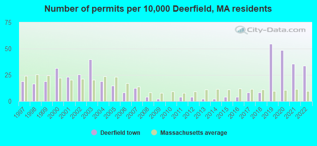
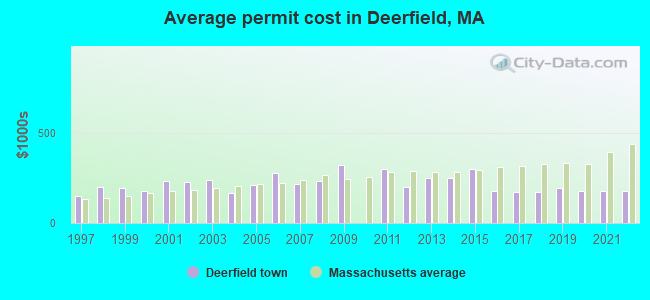
Single-family new house construction building permits:
- 2022: 16 buildings, average cost: $176,500
- 2021: 17 buildings, average cost: $175,000
- 2020: 23 buildings, average cost: $179,000
- 2019: 26 buildings, average cost: $194,900
- 2018: 4 buildings, average cost: $170,000
- 2017: 4 buildings, average cost: $170,000
- 2016: 2 buildings, average cost: $175,000
- 2015: 2 buildings, average cost: $300,000
- 2014: 1 building, cost: $250,000
- 2013: 1 building, cost: $250,000
- 2012: 2 buildings, average cost: $200,000
- 2011: 2 buildings, average cost: $300,000
- 2009: 1 building, cost: $322,000
- 2008: 2 buildings, average cost: $232,500
- 2007: 6 buildings, average cost: $215,500
- 2006: 4 buildings, average cost: $279,100
- 2005: 7 buildings, average cost: $212,400
- 2004: 9 buildings, average cost: $165,200
- 2003: 19 buildings, average cost: $240,400
- 2002: 12 buildings, average cost: $224,300
- 2001: 11 buildings, average cost: $232,200
- 2000: 15 buildings, average cost: $177,900
- 1999: 9 buildings, average cost: $195,200
- 1998: 8 buildings, average cost: $197,000
- 1997: 9 buildings, average cost: $148,700
| Here: | 2.5% |
| Massachusetts: | 3.5% |
- Educational services (18.7%)
- Health care (14.2%)
- Construction (6.3%)
- Public administration (6.2%)
- Professional, scientific, technical services (5.0%)
- Repair & maintenance (3.4%)
- Finance & insurance (3.2%)
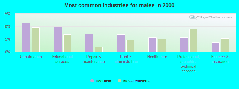
- Construction (11.3%)
- Educational services (9.8%)
- Repair & maintenance (7.1%)
- Public administration (6.9%)
- Health care (5.7%)
- Professional, scientific, technical services (5.7%)
- Finance & insurance (3.7%)
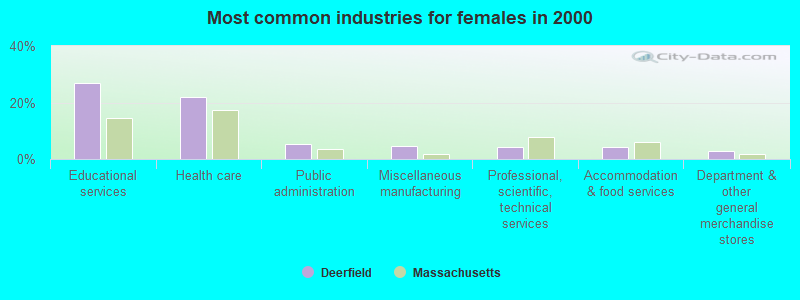
- Educational services (26.8%)
- Health care (21.9%)
- Public administration (5.5%)
- Miscellaneous manufacturing (4.5%)
- Professional, scientific, technical services (4.3%)
- Accommodation & food services (4.2%)
- Department & other general merchandise stores (2.9%)
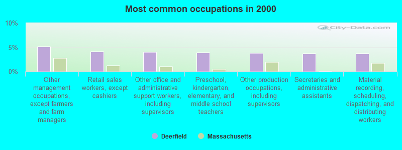
- Other management occupations, except farmers and farm managers (5.2%)
- Retail sales workers, except cashiers (4.1%)
- Other office and administrative support workers, including supervisors (4.0%)
- Preschool, kindergarten, elementary, and middle school teachers (3.9%)
- Other production occupations, including supervisors (3.8%)
- Secretaries and administrative assistants (3.8%)
- Material recording, scheduling, dispatching, and distributing workers (3.7%)
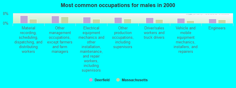
- Material recording, scheduling, dispatching, and distributing workers (6.4%)
- Other management occupations, except farmers and farm managers (6.1%)
- Electrical equipment mechanics and other installation, maintenance, and repair workers, including supervisors (5.0%)
- Other production occupations, including supervisors (4.8%)
- Driver/sales workers and truck drivers (4.6%)
- Vehicle and mobile equipment mechanics, installers, and repairers (4.2%)
- Engineers (3.6%)
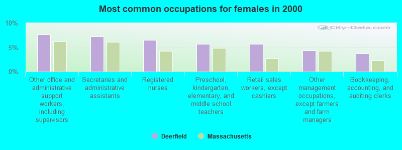
- Other office and administrative support workers, including supervisors (7.6%)
- Secretaries and administrative assistants (7.2%)
- Registered nurses (6.5%)
- Preschool, kindergarten, elementary, and middle school teachers (5.7%)
- Retail sales workers, except cashiers (5.7%)
- Other management occupations, except farmers and farm managers (4.3%)
- Bookkeeping, accounting, and auditing clerks (3.7%)
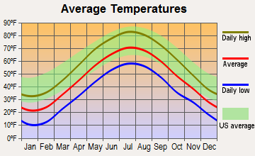
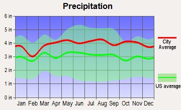
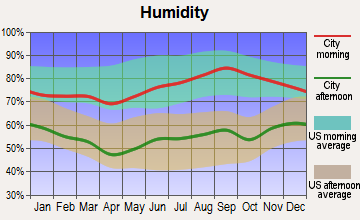
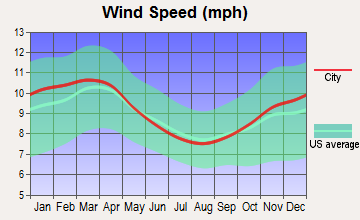
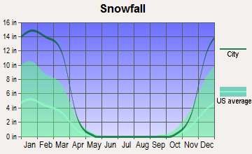
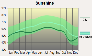
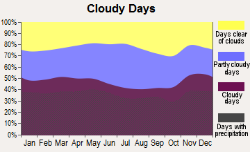
Average climate in Deerfield, Massachusetts
Based on data reported by over 4,000 weather stations
(lower is better)
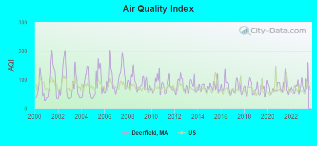
Air Quality Index (AQI) level in 2022 was 73.1. This is about average.
| City: | 73.1 |
| U.S.: | 72.6 |
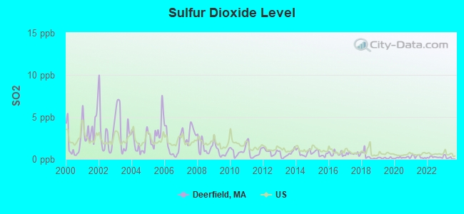
Sulfur Dioxide (SO2) [ppb] level in 2022 was 0.216. This is significantly better than average. Closest monitor was 3.9 miles away from the city center.
| City: | 0.216 |
| U.S.: | 1.515 |
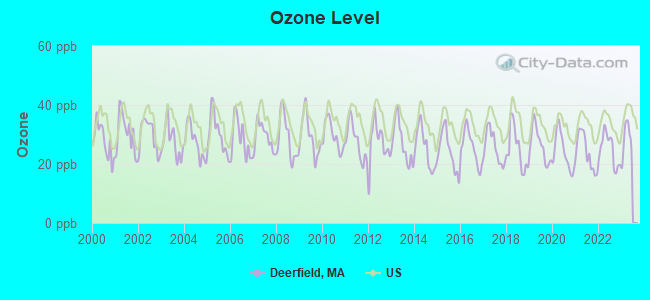
Ozone [ppb] level in 2022 was 24.8. This is better than average. Closest monitor was 3.9 miles away from the city center.
| City: | 24.8 |
| U.S.: | 33.3 |
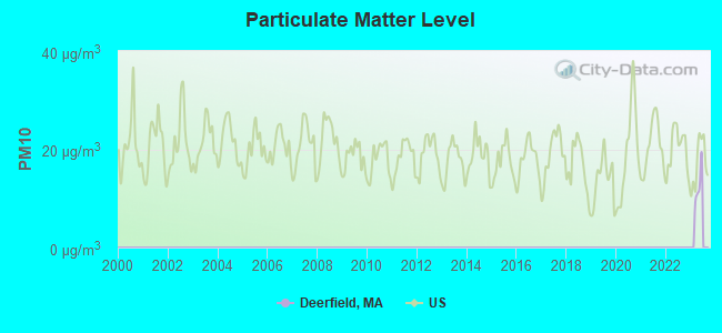
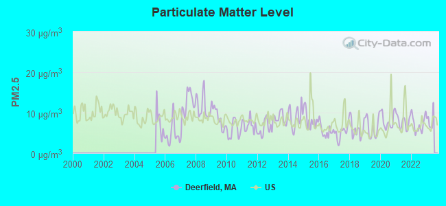
Particulate Matter (PM2.5) [µg/m3] level in 2022 was 7.17. This is about average. Closest monitor was 6.2 miles away from the city center.
| City: | 7.17 |
| U.S.: | 8.11 |
Tornado activity:
Deerfield-area historical tornado activity is above Massachusetts state average. It is 11% smaller than the overall U.S. average.
On 6/9/1953, a category F4 (max. wind speeds 207-260 mph) tornado 22.8 miles away from the Deerfield town center killed 90 people and injured 1228 people and caused between $50,000,000 and $500,000,000 in damages.
On 10/3/1979, a category F4 tornado 32.6 miles away from the town center killed 3 people and injured 500 people and caused between $50,000,000 and $500,000,000 in damages.
Earthquake activity:
Deerfield-area historical earthquake activity is significantly above Massachusetts state average. It is 70% smaller than the overall U.S. average.On 10/7/1983 at 10:18:46, a magnitude 5.3 (5.1 MB, 5.3 LG, 5.1 ML, Class: Moderate, Intensity: VI - VII) earthquake occurred 132.1 miles away from the city center
On 4/20/2002 at 10:50:47, a magnitude 5.3 (5.3 ML, Depth: 3.0 mi) earthquake occurred 148.3 miles away from Deerfield center
On 4/20/2002 at 10:50:47, a magnitude 5.2 (5.2 MB, 4.2 MS, 5.2 MW, 5.0 MW) earthquake occurred 147.1 miles away from the city center
On 1/19/1982 at 00:14:42, a magnitude 4.7 (4.5 MB, 4.7 MD, 4.5 LG, Class: Light, Intensity: IV - V) earthquake occurred 85.2 miles away from Deerfield center
On 10/16/2012 at 23:12:25, a magnitude 4.7 (4.7 ML, Depth: 10.0 mi) earthquake occurred 124.0 miles away from Deerfield center
On 10/2/1994 at 11:27:22, a magnitude 3.7 (3.5 LG, 3.7 LG, Depth: 6.2 mi, Class: Light, Intensity: II - III) earthquake occurred 20.8 miles away from Deerfield center
Magnitude types: regional Lg-wave magnitude (LG), body-wave magnitude (MB), duration magnitude (MD), local magnitude (ML), surface-wave magnitude (MS), moment magnitude (MW)
Natural disasters:
The number of natural disasters in Franklin County (20) is greater than the US average (15).Major Disasters (Presidential) Declared: 9
Emergencies Declared: 10
Causes of natural disasters: Floods: 5, Storms: 5, Hurricanes: 4, Snowstorms: 4, Winter Storms: 3, Blizzards: 2, Snows: 2, Snowfall: 1, Tropical Storm: 1, Wind: 1, Other: 1 (Note: some incidents may be assigned to more than one category).

Hospitals and medical centers near Deerfield:
- BUCKLEY-GREENFIELD HEALTHCARE CENTER (Nursing Home, about 5 miles away; GREENFIELD, MA)
- COZY CORNER NURSING AND REHABILITATION CENTER (Nursing Home, about 5 miles away; SUNDERLAND, MA)
- GENTIVA HEALTH SERVICES (Home Health Center, about 5 miles away; GREENFIELD, MA)
- HOME CARE PRN INC (Home Health Center, about 6 miles away; GREENFIELD, MA)
- CHARLENE MANOR EXTENDED CARE FACILITY (Nursing Home, about 6 miles away; GREENFIELD, MA)
- BAYSTATE FRANKLIN MEDICAL CENTER Acute Care Hospitals (about 6 miles away; GREENFIELD, MA)
- HOSPICE OF FRANKLIN COUNTY (Hospital, about 6 miles away; GREENFIELD, MA)
Operable nuclear power plant near Deerfield:
- 19 miles: Vermont Yankee in Vernon, VT.
Colleges/universities with over 2000 students nearest to Deerfield:
- University of Massachusetts-Amherst (about 11 miles; Amherst, MA; Full-time enrollment: 26,583)
- Smith College (about 14 miles; Northampton, MA; FT enrollment: 3,549)
- Mount Holyoke College (about 19 miles; South Hadley, MA; FT enrollment: 2,573)
- Holyoke Community College (about 23 miles; Holyoke, MA; FT enrollment: 4,911)
- American International College (about 29 miles; Springfield, MA; FT enrollment: 2,733)
- Western New England University (about 29 miles; Springfield, MA; FT enrollment: 3,477)
- Westfield State University (about 29 miles; Westfield, MA; FT enrollment: 5,548)
Points of interest:
Notable locations in Deerfield: Deerfield Fire Department Station 1 Headquarters (A), Historic Deerfield and Pocumtuck Valley Memorial Library (B). Display/hide their locations on the map
Church in Deerfield: First Church of Deerfield (A). Display/hide its location on the map
Cemeteries: Old Albany Cemetery (1), Laurel Hill Cemetery (2). Display/hide their locations on the map
Streams, rivers, and creeks: The Oxbow (A). Display/hide its location on the map
Park in Deerfield: Old Deerfield Village Historic District (1). Display/hide its location on the map
Tourist attractions: Deerfield Museums - Indian House (Memorial), Memorial Hall Museum (Cultural Attractions- Events- & Facilities; 8 Memorial Street).
Birthplace of: Mark Chmura - Football player, Ralph Hosmer - Botanist, William W. Rice - Politician.
Drinking water stations with addresses in Deerfield and their reported violations in the past:
DEERFIELD FIRE DISTRICT (Population served: 1,257, Groundwater under infl of surface water):Past monitoring violations:EAGLEBROOK SCHOOL (Population served: 350, Groundwater):
- One minor monitoring violation
- 2 regular monitoring violations
Past monitoring violations:WOOLMAN HILL (Population served: 25, Groundwater):
- 24 regular monitoring violations
Past monitoring violations:
- 2 minor monitoring violations
| This town: | 2.3 people |
| Massachusetts: | 2.5 people |
| This town: | 65.8% |
| Whole state: | 63.0% |
| This town: | 7.8% |
| Whole state: | 7.0% |
Likely homosexual households (counted as self-reported same-sex unmarried-partner households)
- Lesbian couples: 1.0% of all households
- Gay men: 0.4% of all households
| This town: | 4.5% |
| Whole state: | 9.3% |
| This town: | 1.0% |
| Whole state: | 4.4% |
People in group quarters in Deerfield in 2010:
- 294 people in workers' group living quarters and job corps centers
- 34 people in college/university student housing
- 4 people in group homes intended for adults
4 people in homes for the mentally retarded in 2000
For population 15 years and over in Deerfield:
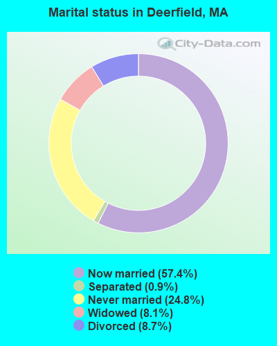
- Never married: 24.8%
- Now married: 57.4%
- Separated: 0.9%
- Widowed: 8.1%
- Divorced: 8.7%
For population 25 years and over in Deerfield:
- High school or higher: 89.3%
- Bachelor's degree or higher: 35.4%
- Graduate or professional degree: 15.4%
- Unemployed: 3.8%
- Mean travel time to work (commute): 22.7 minutes
| Here: | 11.0 |
| Massachusetts average: | 13.1 |


Graphs represent county-level data. Detailed 2008 Election Results
Religion statistics for Deerfield, MA (based on Franklin County data)


| Religion | Adherents | Congregations |
|---|---|---|
| Catholic | 16,509 | 15 |
| Mainline Protestant | 4,617 | 38 |
| Evangelical Protestant | 2,079 | 20 |
| Other | 1,580 | 21 |
| None | 46,587 | - |
Food Environment Statistics:
| Franklin County: | 3.63 / 10,000 pop. |
| Massachusetts: | 1.98 / 10,000 pop. |
| Franklin County: | 0.14 / 10,000 pop. |
| State: | 0.05 / 10,000 pop. |
| Here: | 1.67 / 10,000 pop. |
| Massachusetts: | 2.22 / 10,000 pop. |
| Here: | 3.21 / 10,000 pop. |
| Massachusetts: | 1.77 / 10,000 pop. |
| Franklin County: | 8.10 / 10,000 pop. |
| State: | 8.76 / 10,000 pop. |
| Here: | 7.5% |
| State: | 8.1% |
| Franklin County: | 22.2% |
| State: | 22.5% |
| This county: | 15.1% |
| Massachusetts: | 16.5% |
Strongest AM radio stations in Deerfield:
- WIZZ (1520 AM; daytime; 10 kW; GREENFIELD, MA; Owner: P. & M. RADIO, LLC)
- WNNZ (640 AM; 50 kW; WESTFIELD, MA; Owner: CLEAR CHANNEL BROADCASTING LICENSES, INC.)
- WCRN (830 AM; 50 kW; WORCESTER, MA; Owner: CARTER BROADCASTING CORPORATION)
- WHMQ (1240 AM; 1 kW; GREENFIELD, MA; Owner: SAGA COMMUNICATIONS OF NEW ENGLAND, LLC)
- WVNE (760 AM; daytime; 25 kW; LEICESTER, MA; Owner: BLOUNT MASSCOM, INC.)
- WPNI (1430 AM; 5 kW; AMHERST, MA; Owner: WESTERN MASSACHUSETTS RADIO COMPANY)
- WTIC (1080 AM; 50 kW; HARTFORD, CT; Owner: INFINITY RADIO OPERATIONS INC.)
- WHYN (560 AM; 5 kW; SPRINGFIELD, MA; Owner: CLEAR CHANNEL BROADCASTING LICENSES, INC.)
- WRKO (680 AM; 50 kW; BOSTON, MA; Owner: ENTERCOM BOSTON LICENSE, LLC)
- WALE (990 AM; 50 kW; GREENVILLE, RI; Owner: NORTH AMERICAN BROADCASTING CO., INC.)
- WEEI (850 AM; 50 kW; BOSTON, MA; Owner: ENTERCOM BOSTON LICENSE, LLC)
- WACE (730 AM; 5 kW; CHICOPEE, MA; Owner: CARTER BROADCASTING CORP.)
- WCAT (700 AM; daytime; 2 kW; ORANGE-ATHOL, MA; Owner: CITADEL BROADCASTING COMPANY)
Strongest FM radio stations in Deerfield:
- WGAJ (91.7 FM; DEERFIELD, MA; Owner: TRUATEES OF DEERFIELD ACADEMY)
- WRSI (93.9 FM; TURNERS FALLS, MA; Owner: GREAT NORTHERN RADIO, LLC)
- WHAI (98.3 FM; GREENFIELD, MA; Owner: SAGA COMMUNICATIONS OF NEW ENGLAND, LLC)
- WFCR (88.5 FM; AMHERST, MA; Owner: UNIVERSITY OF MASSACHUSETTS)
- WPVQ (95.3 FM; GREENFIELD, MA; Owner: GREAT NORTHERN RADIO, L.L.C.)
- WAMC-FM (90.3 FM; ALBANY, NY; Owner: WAMC)
- WAMH (89.3 FM; AMHERST, MA; Owner: TRUSTEES OF AMHERST COLLEGE)
- WHYN-FM (93.1 FM; SPRINGFIELD, MA; Owner: CLEAR CHANNEL BROADCASTING LICENSES, INC.)
- WLZX (99.3 FM; NORTHAMPTON, MA; Owner: SAGA COMMUNICATIONS OF NEW ENGLAND, LLC)
- WRNX (100.9 FM; AMHERST, MA; Owner: WESTERN MASSACHUSETTS RADIO COMPANY)
- W246AM (97.1 FM; AMHERST, MA; Owner: GREAT NORTHERN RADIO, LLC)
- WVAY (100.7 FM; WILMINGTON, VT; Owner: GREAT NORTHERN RADIO, L.L.C.)
- WEQX (102.7 FM; MANCHESTER, VT; Owner: NORTHSHIRE COMMUNICATIONS, INC.)
- WEIB (106.3 FM; NORTHAMPTON, MA; Owner: CUTTING EDGE BROADCASTING, INC.)
- WYRY (104.9 FM; HINSDALE, NH; Owner: TRI-VALLEY BROADCASTING CORPORATION)
- WJAN (95.1 FM; SUNDERLAND, VT; Owner: 6 JOHNSON ROAD LICENSES, INC.)
- WRSY (101.5 FM; MARLBORO, VT; Owner: GREAT NORTHERN RADIO, L.L.C.)
- WJDF (97.3 FM; ORANGE, MA; Owner: DEANE BROTHERS BROADCASTING CORP.)
- WHDQ (106.1 FM; CLAREMONT, NH; Owner: GREAT NORTHERN RADIO, L.L.C.)
- WFEX (92.1 FM; PETERBOROUGH, NH; Owner: FNX BROADCASTING OF NEW HAMPSHIRE LLC)
TV broadcast stations around Deerfield:
- WYDN (Channel 48; WORCESTER, MA; Owner: EDUCATIONAL PUBLIC TV CORPORATION)
- WTIC-TV (Channel 61; HARTFORD, CT; Owner: TRIBUNE TELEVISION COMPANY)
- WUNI (Channel 27; WORCESTER, MA; Owner: ENTRAVISION HOLDINGS, LLC)
- W35BK (Channel 35; PLAINFIELD, MA; Owner: LYDIA SYLVANE STOCKWELL)
- WWLP (Channel 22; SPRINGFIELD, MA; Owner: WWLP BROADCASTING, LLC)
- W67DF (Channel 67; SPRINGFIELD, MA; Owner: TRINITY BROADCASTING NETWORK)
- National Bridge Inventory (NBI) Statistics
- 16Number of bridges
- 443ft / 135mTotal length
- $67,828,000Total costs
- 149,394Total average daily traffic
- 13,131Total average daily truck traffic
- 107,061Total future (year 2031) average daily traffic
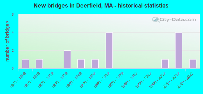
- New bridges - historical statistics
- 11900-1909
- 11910-1919
- 21930-1939
- 11940-1949
- 11950-1959
- 41960-1969
- 12000-2009
- 42010-2019
- 12020-2022
FCC Registered Cell Phone Towers:
1- 76 Old Pinenook Rd (Lat: 42.533194 Lon: -72.591778), Type: Ltower, Structure height: 38.4 m, Overall height: 40.5 m, Call Sign: KNKN769
Assigned Frequencies: 880.020 MHz, 880.020 MHz, 880.020 MHz, 835.020 MHz, 835.020 MHz, 835.020 MHz, 891.510 MHz, 891.510 MHz, 891.510 MHz, 846.510 MHz, 846.510 MHz, 846.510 MHzGrant Date: 09/08/2021, Expiration Date: 10/01/2031, Certifier: Michael P GogginRegistrant: At&t Services, Inc., 208 S Akard St, 20f, Dallas, TX 75202, Phone: (855) 699-7073, Email:
FCC Registered Antenna Towers:
2- Douglas I Brandon, Ridge Road Off Pine Nook Road (Lat: 42.533889 Lon: -72.592500), Type: 28.7, Overall height: 28.7 m, Registrant: At&t Wireless Services, Inc., Esther.Hilliard@attws.Com, , Washi-ngton, Phone: (202) 223-9222
- Douglas I Brandon, Ridge Road Off Pine Nook Road (Lat: 42.533889 Lon: -72.592500), Type: 28.7, Overall height: 28.7 m, Registrant: At&t Wireless Services, Inc., Esther.Hilliard@attws.Com, , Washi-ngton, Phone: (202) 223-9222
FCC Registered Broadcast Land Mobile Towers:
8 (See the full list of FCC Registered Broadcast Land Mobile Towers in Deerfield, MA)FCC Registered Microwave Towers:
6- Pocumtuck Peak, Pocumtuck Peak Ridge Rd. (Lat: 42.533694 Lon: -72.592306), Type: Tower, Structure height: 27 m, Call Sign: WMV430,
Assigned Frequencies: 947.500 MHz, Grant Date: 02/16/1995, Expiration Date: 04/01/2014, Cancellation Date: 03/19/2007, Registrant: Smithwick & Belendiuk, P.C., 5028 Wisconsin Avenue, Nw Suite 301, Washington, DC 20016, Phone: (202) 363-4050, Fax: (202) 363-4266, Email:
- Pocumtuck, 76 Old Pine Nook Rd. (Lat: 42.533694 Lon: -72.591750), Type: Tower, Structure height: 36.6 m, Overall height: 40.2 m, Call Sign: WNTX928,
Assigned Frequencies: 6315.84 MHz, 6004.50 MHz, Grant Date: 12/25/2009, Expiration Date: 02/13/2020, Cancellation Date: 11/15/2019, Registrant: Keller And Heckman LLP, 1001 G Street Nw, Suite 500 West, Washington, DC 20001, Phone: (202) 434-4100, Fax: (202) 434-4646, Email:
- Pocumtuck Peak, Atop Pocumtuck Peak (Lat: 42.533694 Lon: -72.592306), Type: Tower, Structure height: 27 m, Call Sign: WQGK737,
Assigned Frequencies: 947.500 MHz, Grant Date: 02/16/2007, Expiration Date: 04/01/2030, Certifier: Marcia K Lobaito, Registrant: Smithwick & Belendiuk, P.C., 5028 Wisconsin Avenue, Nw Suite 301, Washington, DC 20016, Phone: (202) 363-4050, Fax: (202) 363-4266, Email:
- CT13XC244, 76 Pine Nook Rd (Lat: 42.533778 Lon: -72.592500), Type: Ltower, Structure height: 27.4 m, Call Sign: WQPU532,
Assigned Frequencies: 11345.0 MHz, 11385.0 MHz, 11425.0 MHz, 11345.0 MHz, 11385.0 MHz, 11425.0 MHz, 11345.0 MHz, 11385.0 MHz, 11425.0 MHz, Grant Date: 08/17/2012, Expiration Date: 08/17/2022, Cancellation Date: 08/10/2022, Certifier: David Werblow, Registrant: Dla Piper LLP, 500 8th Street, Nw, Washington, DC 20004, Phone: (202) 799-4216, Fax: (202) 799-5616, Email:
- Pocumtuck, New Pocumtuck - Old Pine Nook Road (Lat: 42.533194 Lon: -72.591917), Type: Ltower, Structure height: 36.5 m, Overall height: 40.2 m, Call Sign: WQVN233,
Assigned Frequencies: 6004.50 MHz, 6315.84 MHz, Grant Date: 04/02/2015, Expiration Date: 04/02/2025, Certifier: James Ahrens, Registrant: Keller And Heckman LLP, 1001 G Street Nw, Suite 500 West, Washington, DC 20001, Phone: (202) 434-4100, Fax: (202) 434-4646, Email:
- Little Meadow Rd., 6 Little Meadow Rd. (Lat: 42.546917 Lon: -72.607556), Type: Bant, Structure height: 7.9 m, Overall height: 11.4 m, Call Sign: WHY893,
Assigned Frequencies: 948.875 MHz, Grant Date: 07/16/1984, Expiration Date: 04/01/2030, Registrant: Carl E. Smith Consulting Engineers, 2324 N. Cleveland-Massillon Rd., Bath, OH 44210-0807, Phone: (330) 659-4440, Fax: (330) 659-9234
FCC Registered Amateur Radio Licenses:
12 (See the full list of FCC Registered Amateur Radio Licenses in Deerfield)FAA Registered Aircraft Manufacturers and Dealers:
1- STRICKLAND DAVID, 109 Plain Rd W, S Deerfield, MA 01373
Certificate: 02-1100 (Individual), Certificate Issue Date: 06/26/2002, Expiration Date: 06/25/2003
2002 - 2018 National Fire Incident Reporting System (NFIRS) incidents
- Fire incident types reported to NFIRS in Deerfield, MA
- 9042.3%Outside Fires
- 8238.5%Structure Fires
- 3114.6%Mobile Property/Vehicle Fires
- 104.7%Other
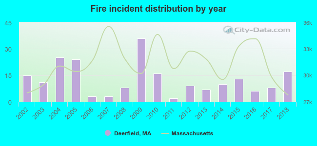 Based on the data from the years 2002 - 2018 the average number of fires per year is 13. The highest number of fire incidents - 36 took place in 2009, and the least - 2 in 2011. The data has a growing trend.
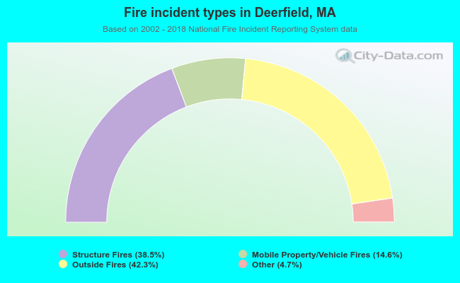 When looking into fire subcategories, the most reports belonged to: Outside Fires (42.3%), and Structure Fires (38.5%).
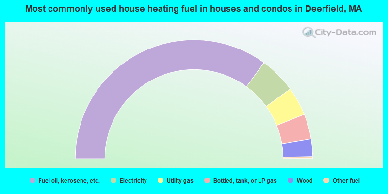
- 70.0%Fuel oil, kerosene, etc.
- 10.0%Electricity
- 7.8%Utility gas
- 6.8%Bottled, tank, or LP gas
- 4.8%Wood
- 0.5%Other fuel
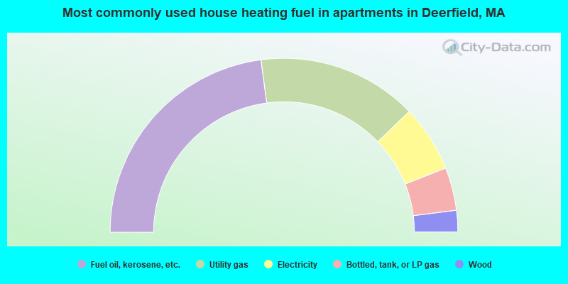
- 45.8%Fuel oil, kerosene, etc.
- 29.8%Utility gas
- 12.4%Electricity
- 8.0%Bottled, tank, or LP gas
- 4.0%Wood
Deerfield compared to Massachusetts state average:
- Unemployed percentage significantly below state average.
- Black race population percentage significantly below state average.
- Hispanic race population percentage significantly below state average.
- Median age above state average.
- Foreign-born population percentage significantly below state average.
- Length of stay since moving in significantly above state average.
- Number of rooms per house significantly below state average.
- House age significantly below state average.
Deerfield on our top lists:
- #7 on the list of "Top 101 cities with largest percentage of males in occupations: judges, magistrates, and other judicial workers (population 5,000+)"
- #10 on the list of "Top 101 cities with largest percentage of males in industries: repair and maintenance (population 5,000+)"
- #11 on the list of "Top 101 cities with largest percentage of males in occupations: child care workers (population 5,000+)"
- #13 on the list of "Top 101 cities with largest percentage of males in industries: used merchandise, gift, novelty, and souvenir, and other miscellaneous stores (population 5,000+)"
- #20 on the list of "Top 101 cities with largest percentage of females in occupations: carpenters (population 5,000+)"
- #23 on the list of "Top 101 cities with largest percentage of males in occupations: material recording, scheduling, dispatching, and distributing workers (population 5,000+)"
- #24 on the list of "Top 101 cities with largest percentage of females in occupations: secondary school teachers (population 5,000+)"
- #25 on the list of "Top 101 cities with largest percentage of males in industries: water transportation (population 5,000+)"
- #30 on the list of "Top 101 cities with largest percentage of females in industries: miscellaneous manufacturing (population 5,000+)"
- #30 on the list of "Top 101 cities with largest percentage of males in occupations: legal support workers (population 5,000+)"
- #40 on the list of "Top 101 cities with largest percentage of males in industries: religious, grantmaking, civic, professional, and similar organizations (population 5,000+)"
- #40 on the list of "Top 101 cities with largest percentage of males in industries: electronic shopping and mail-order houses (population 5,000+)"
- #41 on the list of "Top 101 cities with largest percentage of females in industries: building material and garden equipment and supplies dealers (population 5,000+)"
- #58 on the list of "Top 101 cities with the largest percentage of likely lesbian couples (counted as self-reported female-female unmarried-partner households) (population 5,000+)"
- #73 on the list of "Top 101 cities with largest percentage of males in industries: plastics and rubber products (population 5,000+)"
- #80 on the list of "Top 101 cities with largest percentage of males in industries: groceries and related products merchant wholesalers (population 5,000+)"
- #81 on the list of "Top 101 cities with largest percentage of males in industries: petroleum and petroleum products merchant wholesalers (population 5,000+)"
- #83 on the list of "Top 101 cities with largest percentage of females in industries: electronic shopping and mail-order houses (population 5,000+)"
- #83 on the list of "Top 101 cities with largest percentage of males in industries: music stores (population 5,000+)"
- #90 on the list of "Top 101 cities with largest percentage of females in industries: health care (population 5,000+)"
- #21 on the list of "Top 101 counties with the highest percentage of residents that drank alcohol in the past 30 days"
- #65 on the list of "Top 101 counties with the lowest average weight of females"
- #84 on the list of "Top 101 counties with the lowest surface withdrawal of fresh water for public supply (pop. 50,000+)"
- #88 on the list of "Top 101 counties with the best general health status score of residents (1-5), 3 years of data"
- #92 on the list of "Top 101 counties with the highest percentage of residents that smoked 100+ cigarettes in their lives"

|
|
Total of 10 patent applications in 2008-2024.