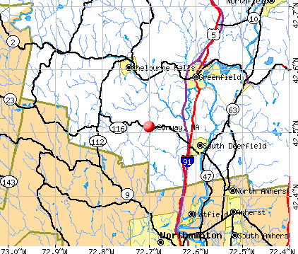
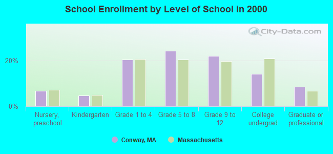
Conway, Massachusetts
Submit your own pictures of this town and show them to the world
- OSM Map
- General Map
- Google Map
- MSN Map
Population change since 2000: +4.9%
 |
| Males: 924 | |
| Females: 973 |
| Median resident age: | 46.3 years |
| Massachusetts median age: | 39.2 years |
Zip codes: 01341.
| Conway: | $96,736 |
| MA: | $94,488 |
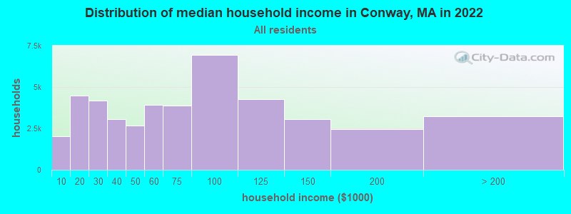
Estimated per capita income in 2022: $46,651 (it was $25,605 in 2000)
Conway town income, earnings, and wages data
Estimated median house or condo value in 2022: $426,207 (it was $171,500 in 2000)
| Conway: | $426,207 |
| MA: | $534,700 |
Mean prices in 2022: all housing units: $313,377; detached houses: $324,224; townhouses or other attached units: $284,225; in 2-unit structures: $287,978; in 3-to-4-unit structures: $183,938; in 5-or-more-unit structures: $249,762; mobile homes: $62,200
Detailed information about poverty and poor residents in Conway, MA


- 1,80995.4%White alone
- 361.9%Two or more races
- 281.5%Hispanic
- 110.6%Asian alone
- 70.4%American Indian alone
- 30.2%Black alone
- 20.1%Native Hawaiian and Other
Pacific Islander alone - 10.05%Other race alone
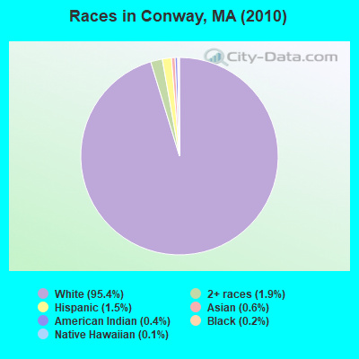
Races in Conway detailed stats: ancestries, foreign born residents, place of birth
 Recent articles from our blog. Our writers, many of them Ph.D. graduates or candidates, create easy-to-read articles on a wide variety of topics.

 | I'm loving this rain! (148 replies) |
| 2021 Real Estate Observations (1729 replies) |
| Is it possible to escape hunters, ATVs and noise in a rural area? (278 replies) |
| Moving to Massachusetts (75 replies) |
| Coronavirus in Massachusetts (18047 replies) |
| Is Mass stressful or not? (47 replies) |
Latest news from Conway, MA collected exclusively by city-data.com from local newspapers, TV, and radio stations
Ancestries: English (24.0%), Irish (19.7%), German (12.4%), Polish (11.9%), French (8.8%), French Canadian (8.2%).
Current Local Time: EST time zone
Incorporated in 1775
Elevation: 620 feet
Land area: 37.7 square miles.
Population density: 50 people per square mile (very low).
40 residents are foreign born (1.1% Europe, 0.5% Asia).
| This town: | 2.2% |
| Massachusetts: | 12.2% |
| Conway town: | 1.5% ($2,526) |
| Massachusetts: | 1.3% ($2,336) |
Nearest city with pop. 50,000+: Chicopee, MA  (24.2 miles , pop. 54,653).
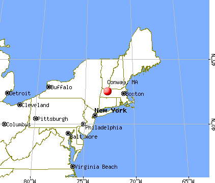
Nearest city with pop. 200,000+: Boston, MA (83.6 miles , pop. 589,141).
Nearest city with pop. 1,000,000+: Bronx, NY (129.8 miles , pop. 1,332,650).
Nearest cities:
)Latitude: 42.51 N, Longitude: 72.71 W
Area code: 413

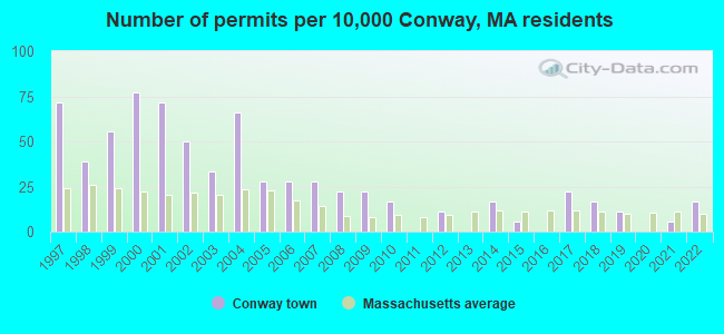
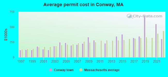
Single-family new house construction building permits:
- 2022: 3 buildings, average cost: $303,300
- 2021: 1 building, cost: $550,000
- 2019: 2 buildings, average cost: $690,400
- 2018: 3 buildings, average cost: $347,300
- 2017: 4 buildings, average cost: $321,400
- 2015: 1 building, cost: $380,000
- 2014: 3 buildings, average cost: $348,300
- 2012: 2 buildings, average cost: $233,500
- 2010: 3 buildings, average cost: $286,400
- 2009: 4 buildings, average cost: $332,700
- 2008: 4 buildings, average cost: $227,500
- 2007: 5 buildings, average cost: $211,600
- 2006: 5 buildings, average cost: $199,800
- 2005: 5 buildings, average cost: $240,800
- 2004: 12 buildings, average cost: $249,100
- 2003: 6 buildings, average cost: $185,700
- 2002: 9 buildings, average cost: $121,100
- 2001: 13 buildings, average cost: $135,300
- 2000: 14 buildings, average cost: $182,300
- 1999: 10 buildings, average cost: $124,800
- 1998: 7 buildings, average cost: $126,800
- 1997: 13 buildings, average cost: $120,800
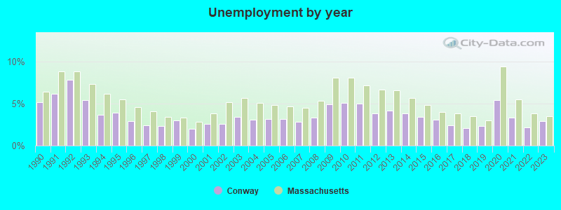
| Here: | 2.9% |
| Massachusetts: | 3.5% |
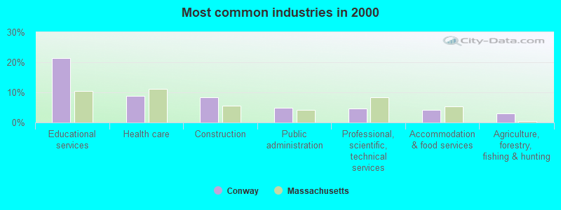
- Educational services (21.4%)
- Health care (8.7%)
- Construction (8.4%)
- Public administration (4.9%)
- Professional, scientific, technical services (4.6%)
- Accommodation & food services (4.1%)
- Agriculture, forestry, fishing & hunting (3.1%)
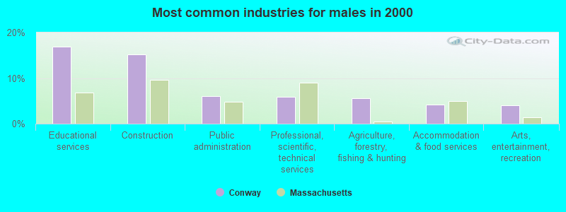
- Educational services (16.9%)
- Construction (15.2%)
- Public administration (6.1%)
- Professional, scientific, technical services (5.9%)
- Agriculture, forestry, fishing & hunting (5.5%)
- Accommodation & food services (4.2%)
- Arts, entertainment, recreation (4.0%)
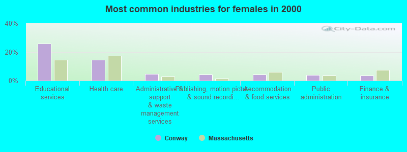
- Educational services (25.9%)
- Health care (14.5%)
- Administrative & support & waste management services (4.7%)
- Publishing, motion picture & sound recording industries (4.1%)
- Accommodation & food services (4.1%)
- Public administration (3.7%)
- Finance & insurance (3.5%)
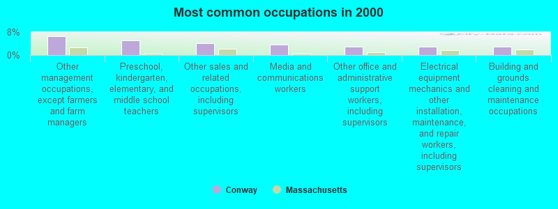
- Other management occupations, except farmers and farm managers (6.5%)
- Preschool, kindergarten, elementary, and middle school teachers (5.2%)
- Other sales and related occupations, including supervisors (4.1%)
- Media and communications workers (3.6%)
- Other office and administrative support workers, including supervisors (2.9%)
- Electrical equipment mechanics and other installation, maintenance, and repair workers, including supervisors (2.9%)
- Building and grounds cleaning and maintenance occupations (2.8%)
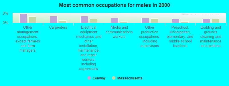
- Other management occupations, except farmers and farm managers (7.4%)
- Carpenters (5.5%)
- Electrical equipment mechanics and other installation, maintenance, and repair workers, including supervisors (5.5%)
- Media and communications workers (4.2%)
- Other production occupations, including supervisors (3.8%)
- Preschool, kindergarten, elementary, and middle school teachers (3.4%)
- Building and grounds cleaning and maintenance occupations (3.4%)
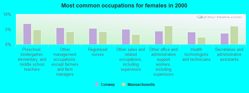
- Preschool, kindergarten, elementary, and middle school teachers (6.9%)
- Other management occupations, except farmers and farm managers (5.6%)
- Registered nurses (5.4%)
- Other sales and related occupations, including supervisors (5.0%)
- Other office and administrative support workers, including supervisors (4.5%)
- Health technologists and technicians (4.1%)
- Secretaries and administrative assistants (3.7%)
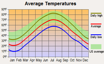
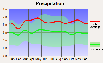
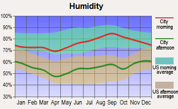
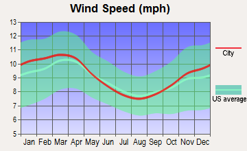
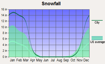
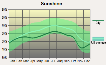
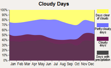
Average climate in Conway, Massachusetts
Based on data reported by over 4,000 weather stations
(lower is better)
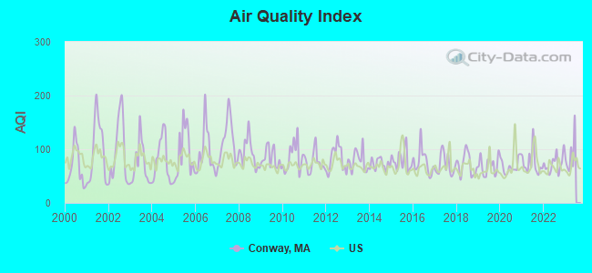
Air Quality Index (AQI) level in 2022 was 73.1. This is about average.
| City: | 73.1 |
| U.S.: | 72.6 |
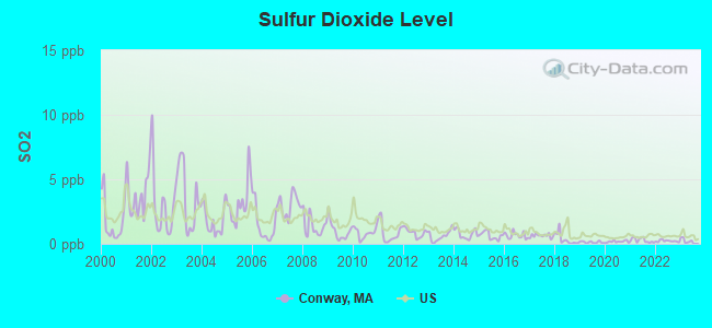
Sulfur Dioxide (SO2) [ppb] level in 2022 was 0.216. This is significantly better than average. Closest monitor was 7.0 miles away from the city center.
| City: | 0.216 |
| U.S.: | 1.515 |
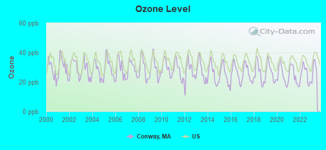
Ozone [ppb] level in 2022 was 25.3. This is better than average. Closest monitor was 7.1 miles away from the city center.
| City: | 25.3 |
| U.S.: | 33.3 |
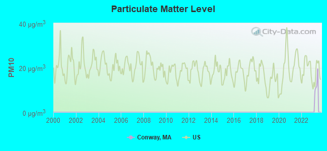
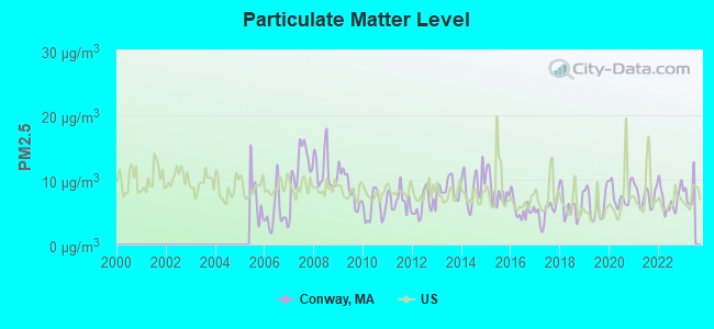
Particulate Matter (PM2.5) [µg/m3] level in 2022 was 7.00. This is about average. Closest monitor was 8.8 miles away from the city center.
| City: | 7.00 |
| U.S.: | 8.11 |
Tornado activity:
Conway-area historical tornado activity is above Massachusetts state average. It is 12% smaller than the overall U.S. average.
On 6/9/1953, a category F4 (max. wind speeds 207-260 mph) tornado 27.5 miles away from the Conway town center killed 90 people and injured 1228 people and caused between $50,000,000 and $500,000,000 in damages.
On 10/3/1979, a category F4 tornado 31.7 miles away from the town center killed 3 people and injured 500 people and caused between $50,000,000 and $500,000,000 in damages.
Earthquake activity:
Conway-area historical earthquake activity is significantly above Massachusetts state average. It is 69% smaller than the overall U.S. average.On 10/7/1983 at 10:18:46, a magnitude 5.3 (5.1 MB, 5.3 LG, 5.1 ML, Class: Moderate, Intensity: VI - VII) earthquake occurred 129.5 miles away from the city center
On 4/20/2002 at 10:50:47, a magnitude 5.3 (5.3 ML, Depth: 3.0 mi) earthquake occurred 147.2 miles away from the city center
On 4/20/2002 at 10:50:47, a magnitude 5.2 (5.2 MB, 4.2 MS, 5.2 MW, 5.0 MW) earthquake occurred 145.9 miles away from the city center
On 1/19/1982 at 00:14:42, a magnitude 4.7 (4.5 MB, 4.7 MD, 4.5 LG, Class: Light, Intensity: IV - V) earthquake occurred 88.5 miles away from the city center
On 10/16/2012 at 23:12:25, a magnitude 4.7 (4.7 ML, Depth: 10.0 mi) earthquake occurred 128.1 miles away from the city center
On 6/17/1991 at 08:53:16, a magnitude 4.1 (4.0 MB, 4.0 LG, Depth: 3.1 mi) earthquake occurred 100.8 miles away from Conway center
Magnitude types: regional Lg-wave magnitude (LG), body-wave magnitude (MB), duration magnitude (MD), local magnitude (ML), surface-wave magnitude (MS), moment magnitude (MW)
Natural disasters:
The number of natural disasters in Franklin County (20) is greater than the US average (15).Major Disasters (Presidential) Declared: 9
Emergencies Declared: 10
Causes of natural disasters: Floods: 5, Storms: 5, Hurricanes: 4, Snowstorms: 4, Winter Storms: 3, Blizzards: 2, Snows: 2, Snowfall: 1, Tropical Storm: 1, Wind: 1, Other: 1 (Note: some incidents may be assigned to more than one category).
Hospitals and medical centers near Conway:
- ANCHORAGE NURSING HOME (Nursing Home, about 7 miles away; SHELBURNE, MA)
- BUCKLEY-GREENFIELD HEALTHCARE CENTER (Nursing Home, about 7 miles away; GREENFIELD, MA)
- CHARLENE MANOR EXTENDED CARE FACILITY (Nursing Home, about 8 miles away; GREENFIELD, MA)
- COZY CORNER NURSING AND REHABILITATION CENTER (Nursing Home, about 8 miles away; SUNDERLAND, MA)
- GENTIVA HEALTH SERVICES (Home Health Center, about 8 miles away; GREENFIELD, MA)
- HOME CARE PRN INC (Home Health Center, about 8 miles away; GREENFIELD, MA)
- HOSPICE OF FRANKLIN COUNTY, INC (Hospital, about 9 miles away; GREENFIELD, MA)
College/University in Conway:
Colleges/universities with over 2000 students nearest to Conway:
- University of Massachusetts-Amherst (about 13 miles; Amherst, MA; Full-time enrollment: 26,583)
- Smith College (about 14 miles; Northampton, MA; FT enrollment: 3,549)
- Mount Holyoke College (about 19 miles; South Hadley, MA; FT enrollment: 2,573)
- Holyoke Community College (about 22 miles; Holyoke, MA; FT enrollment: 4,911)
- Westfield State University (about 27 miles; Westfield, MA; FT enrollment: 5,548)
- Springfield Technical Community College (about 29 miles; Springfield, MA; FT enrollment: 4,750)
- American International College (about 29 miles; Springfield, MA; FT enrollment: 2,733)
Public elementary/middle school in Conway:
- CONWAY GRAMMAR (Students: 166, Location: 24 FOURNIER ROAD, Grades: PK-6)
Points of interest:
Notable locations in Conway: Birchmere Farm and Dairy (A), Roaring Brook Camp (B), Town of Conway Ambulance Service (C), Conway Fire Department (D), Field Memorial Library (E). Display/hide their locations on the map
Churches in Conway include: United Congregational Church (A), Roaring Brook Camp Church (B). Display/hide their locations on the map
Cemeteries: Pine Grove Cemetery (1), Howland Cemetery (2), North Shirkshire Cemetery (3), Southpart Cemetery (4), Cricket Hill Cemetery (5), Boyden Cemetery (6). Display/hide their locations on the map
Lakes, reservoirs, and swamps: City Pond (A), Roaring Brook Reservoir (B), Conway Electric Reservoir (C), Keyes Swamp (D). Display/hide their locations on the map
Streams, rivers, and creeks: Johnny Bean Brook (A), Drakes Brook (B), Chapel Brook (C), Chadwick Brook (D), South River (E), Sinkpot Brook (F), Sids Brook (G), Poplar Hill Brook (H), Pumpkin Hollow Brook (I). Display/hide their locations on the map
Birthplace of: William Collins Whitney - Secretary of the Navy, Caleb Rice - Politician, Harvey Rice - Politician, Marshall Field - Businessman.
| This town: | 2.5 people |
| Massachusetts: | 2.5 people |
| This town: | 69.1% |
| Whole state: | 63.0% |
| This town: | 9.1% |
| Whole state: | 7.0% |
Likely homosexual households (counted as self-reported same-sex unmarried-partner households)
- Lesbian couples: 3.2% of all households
- Gay men: 0.3% of all households
| This town: | 3.5% |
| Whole state: | 9.3% |
| This town: | 0.9% |
| Whole state: | 4.4% |
2 people in other nonhousehold living situations in 2000
Banks with branches in Conway (2011 data):
- Greenfield Savings Bank: Conway Branch at Parsons Road And Route 116, branch established on 1855/03/28. Info updated 2006/10/11: Bank assets: $640.0 mil, Deposits: $458.2 mil, headquarters in Greenfield, MA, positive income, Mortgage Lending Specialization, 6 total offices, Holding Company: Gsb, Mhc
For population 15 years and over in Conway:
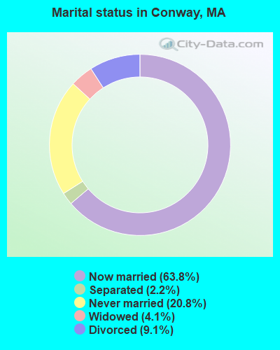
- Never married: 20.8%
- Now married: 63.8%
- Separated: 2.2%
- Widowed: 4.1%
- Divorced: 9.1%
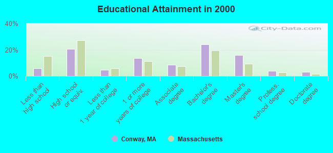
For population 25 years and over in Conway:
- High school or higher: 94.2%
- Bachelor's degree or higher: 46.9%
- Graduate or professional degree: 22.9%
- Unemployed: 4.1%
- Mean travel time to work (commute): 27.4 minutes
| Here: | 10.6 |
| Massachusetts average: | 13.1 |


Graphs represent county-level data. Detailed 2008 Election Results
Religion statistics for Conway, MA (based on Franklin County data)


| Religion | Adherents | Congregations |
|---|---|---|
| Catholic | 16,509 | 15 |
| Mainline Protestant | 4,617 | 38 |
| Evangelical Protestant | 2,079 | 20 |
| Other | 1,580 | 21 |
| None | 46,587 | - |
Food Environment Statistics:
| This county: | 3.63 / 10,000 pop. |
| Massachusetts: | 1.98 / 10,000 pop. |
| Franklin County: | 0.14 / 10,000 pop. |
| State: | 0.05 / 10,000 pop. |
| Franklin County: | 1.67 / 10,000 pop. |
| Massachusetts: | 2.22 / 10,000 pop. |
| Here: | 3.21 / 10,000 pop. |
| Massachusetts: | 1.77 / 10,000 pop. |
| Franklin County: | 8.10 / 10,000 pop. |
| Massachusetts: | 8.76 / 10,000 pop. |
| This county: | 7.5% |
| Massachusetts: | 8.1% |
| This county: | 22.2% |
| State: | 22.5% |
| This county: | 15.1% |
| Massachusetts: | 16.5% |
Strongest AM radio stations in Conway:
- WNNZ (640 AM; 50 kW; WESTFIELD, MA; Owner: CLEAR CHANNEL BROADCASTING LICENSES, INC.)
- WIZZ (1520 AM; daytime; 10 kW; GREENFIELD, MA; Owner: P. & M. RADIO, LLC)
- WCRN (830 AM; 50 kW; WORCESTER, MA; Owner: CARTER BROADCASTING CORPORATION)
- WVNE (760 AM; daytime; 25 kW; LEICESTER, MA; Owner: BLOUNT MASSCOM, INC.)
- WTIC (1080 AM; 50 kW; HARTFORD, CT; Owner: INFINITY RADIO OPERATIONS INC.)
- WHYN (560 AM; 5 kW; SPRINGFIELD, MA; Owner: CLEAR CHANNEL BROADCASTING LICENSES, INC.)
- WHMQ (1240 AM; 1 kW; GREENFIELD, MA; Owner: SAGA COMMUNICATIONS OF NEW ENGLAND, LLC)
- WPNI (1430 AM; 5 kW; AMHERST, MA; Owner: WESTERN MASSACHUSETTS RADIO COMPANY)
- WGY (810 AM; 50 kW; SCHENECTADY, NY; Owner: CLEAR CHANNEL BROADCASTING LICENSES, INC.)
- WRKO (680 AM; 50 kW; BOSTON, MA; Owner: ENTERCOM BOSTON LICENSE, LLC)
- WACE (730 AM; 5 kW; CHICOPEE, MA; Owner: CARTER BROADCASTING CORP.)
- WALE (990 AM; 50 kW; GREENVILLE, RI; Owner: NORTH AMERICAN BROADCASTING CO., INC.)
- WEEI (850 AM; 50 kW; BOSTON, MA; Owner: ENTERCOM BOSTON LICENSE, LLC)
Strongest FM radio stations in Conway:
- WRSI (93.9 FM; TURNERS FALLS, MA; Owner: GREAT NORTHERN RADIO, LLC)
- WHAI (98.3 FM; GREENFIELD, MA; Owner: SAGA COMMUNICATIONS OF NEW ENGLAND, LLC)
- WGAJ (91.7 FM; DEERFIELD, MA; Owner: TRUATEES OF DEERFIELD ACADEMY)
- WAMC-FM (90.3 FM; ALBANY, NY; Owner: WAMC)
- WPVQ (95.3 FM; GREENFIELD, MA; Owner: GREAT NORTHERN RADIO, L.L.C.)
- WFCR (88.5 FM; AMHERST, MA; Owner: UNIVERSITY OF MASSACHUSETTS)
- WLZX (99.3 FM; NORTHAMPTON, MA; Owner: SAGA COMMUNICATIONS OF NEW ENGLAND, LLC)
- WHYN-FM (93.1 FM; SPRINGFIELD, MA; Owner: CLEAR CHANNEL BROADCASTING LICENSES, INC.)
- WRNX (100.9 FM; AMHERST, MA; Owner: WESTERN MASSACHUSETTS RADIO COMPANY)
- WAMH (89.3 FM; AMHERST, MA; Owner: TRUSTEES OF AMHERST COLLEGE)
- WEIB (106.3 FM; NORTHAMPTON, MA; Owner: CUTTING EDGE BROADCASTING, INC.)
- WVAY (100.7 FM; WILMINGTON, VT; Owner: GREAT NORTHERN RADIO, L.L.C.)
- WEQX (102.7 FM; MANCHESTER, VT; Owner: NORTHSHIRE COMMUNICATIONS, INC.)
- W246AM (97.1 FM; AMHERST, MA; Owner: GREAT NORTHERN RADIO, LLC)
- WJAN (95.1 FM; SUNDERLAND, VT; Owner: 6 JOHNSON ROAD LICENSES, INC.)
- WRSY (101.5 FM; MARLBORO, VT; Owner: GREAT NORTHERN RADIO, L.L.C.)
- WYRY (104.9 FM; HINSDALE, NH; Owner: TRI-VALLEY BROADCASTING CORPORATION)
- WHDQ (106.1 FM; CLAREMONT, NH; Owner: GREAT NORTHERN RADIO, L.L.C.)
- WAQY (102.1 FM; SPRINGFIELD, MA; Owner: SAGA COMMUNICATIONS OF NEW ENGLAND, LLC)
- WZEC (97.5 FM; HOOSICK FALLS, NY; Owner: GREAT NORTHERN RADIO, LLC)
TV broadcast stations around Conway:
- W35BK (Channel 35; PLAINFIELD, MA; Owner: LYDIA SYLVANE STOCKWELL)
- WYDN (Channel 48; WORCESTER, MA; Owner: EDUCATIONAL PUBLIC TV CORPORATION)
- WTIC-TV (Channel 61; HARTFORD, CT; Owner: TRIBUNE TELEVISION COMPANY)
- WWLP (Channel 22; SPRINGFIELD, MA; Owner: WWLP BROADCASTING, LLC)
- W67DF (Channel 67; SPRINGFIELD, MA; Owner: TRINITY BROADCASTING NETWORK)
- Conway, Massachusetts
- Fatal accident count8
- Vehicles involved in fatal accidents9
- Fatal accidents involving drunk persons:2
- Fatalities8
- Persons involved in fatal accidents10
- Pedestrians involved in fatal accidents0
- Massachusetts average
- Fatal accident count3194
- Vehicles involved in fatal accidents4533
- Fatal accidents involving drunk persons1099
- Fatalities3420
- Persons involved in fatal accidents7304
- Pedestrians involved in fatal accidents492
- National Bridge Inventory (NBI) Statistics
- 19Number of bridges
- 131ft / 40.1mTotal length
- $36,385,000Total costs
- 20,455Total average daily traffic
- 1,346Total average daily truck traffic
- 32,533Total future (year 21) average daily traffic
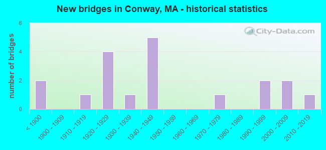
- New bridges - historical statistics
- 2Before 1900
- 11910-1919
- 41920-1929
- 11930-1939
- 51940-1949
- 11970-1979
- 21990-1999
- 22000-2009
- 12010-2019
FCC Registered Broadcast Land Mobile Towers:
3- Conway Firemans Bldg Rt 116 Ashfield Rd (Lat: 42.506750 Lon: -72.702028), Call Sign: KZU980,
Assigned Frequencies: 39.1600 MHz, 39.2400 MHz, Grant Date: 02/08/1996, Expiration Date: 03/11/2001, Cancellation Date: 05/13/2001, Registrant: Conway, Town Of, Main St, Conway, MA 01341, Phone: (413) 369-4968
- 3500 E Of Int Conway Rd & Wilder Hill Rd (Lat: 42.572861 Lon: -72.707583), Structure height: 11 m, Call Sign: WNXS275, Licensee ID: L00006600,
Assigned Frequencies: 48.4200 MHz, 48.4800 MHz, Grant Date: 10/16/1996, Expiration Date: 10/16/2001, Cancellation Date: 10/05/2001, Registrant: National Grid Usa Service Company Inc, 55 Bearfoot Rd, Northborough, MA 01532
- Lat: 42.509139 Lon: -72.673083, Call Sign: WQLY387,
Assigned Frequencies: 452.087 MHz, Grant Date: 03/14/2020, Expiration Date: 05/25/2030, Certifier: Bob Lesko, Registrant: Industrial Communications, 40 Lone Street, Marshfield, MA 02050, Phone: (781) 319-1011, Fax: (781) 837-4000, Email:
FCC Registered Amateur Radio Licenses:
5- Call Sign: N1WNB, Licensee ID: L01078046, Grant Date: 01/12/2016, Expiration Date: 01/26/2026, Certifier: Winston S Burt, Registrant: Winston S Burt, 185 N Poland Rd, Conway, MA 01341
- Call Sign: W2GWI, Licensee ID: L00998588, Grant Date: 03/31/2005, Expiration Date: 06/05/2015, Cancellation Date: 06/06/2017, Certifier: Lloyd G Kent Jr, Registrant: Lloyd G Kent Jr, 624 Bardwell Ferry Rd, Conway, MA 01341
- Call Sign: KB1IPP, Licensee ID: L00548228, Grant Date: 06/19/2012, Expiration Date: 07/22/2022, Certifier: Nicholas Anderson, Registrant: Nicholas Anderson, 949 Roaring Brook Rd, Conway, MA 01341
- Call Sign: KB1NOB, Licensee ID: L00716038, Grant Date: 05/17/2006, Expiration Date: 05/17/2016, Cancellation Date: 05/18/2018, Certifier: Carl Meyer Ii, Registrant: Carl Meyer Ii, 96 Hart Rd, Conway, MA 01341
- Call Sign: KB1NOE, Licensee ID: L01152650, Grant Date: 05/17/2006, Expiration Date: 05/17/2016, Cancellation Date: 05/18/2018, Certifier: Mary C Clayton-Jones, Registrant: Mary C Clayton-Jones, 617 Hoosac Rd, Conway, MA 01341
FAA Registered Aircraft:
2- Aircraft: PIPER PA-28-235 (Category: Land, Seats: 4, Weight: Up to 12,499 Pounds, Speed: 107 mph), Engine: LYCOMING 0-540 SERIES (250 HP) (Reciprocating)
N-Number: 15612, N15612, N-15612, Serial Number: 28-7310060, Year manufactured: 1972, Airworthiness Date: 11/15/1972, Certificate Issue Date: 08/17/1989
Registrant (Individual): Russell A French, 110 Delabarre Ave, Conway, MA 01341 - Aircraft: CESSNA 172S (Category: Land, Seats: 4, Weight: Up to 12,499 Pounds), Engine: LYCOMING IO-360-L2A (180 HP) (Reciprocating)
N-Number: 6024T, N6024T, N-6024T, Serial Number: 172S10202, Year manufactured: 2006, Airworthiness Date: 05/25/2006, Certificate Issue Date: 04/26/2012
Registrant (Individual): Bruce Douglass, 1680 Main Poland Rd, Conway, MA 01341
2002 - 2018 National Fire Incident Reporting System (NFIRS) incidents
- Fire incident types reported to NFIRS in Conway, MA
- 13766.5%Structure Fires
- 5526.7%Outside Fires
- 104.9%Mobile Property/Vehicle Fires
- 41.9%Other
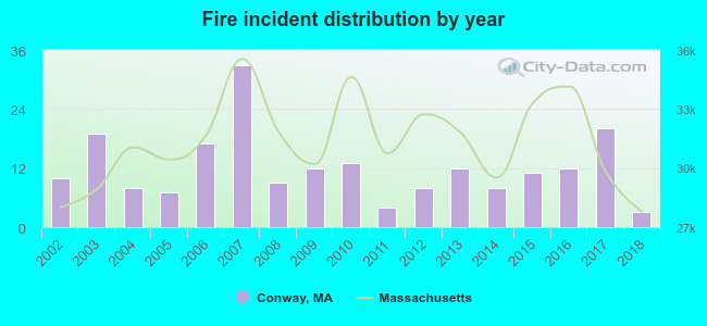 According to the data from the years 2002 - 2018 the average number of fire incidents per year is 12. The highest number of reported fire incidents - 33 took place in 2007, and the least - 3 in 2018. The data has a dropping trend.
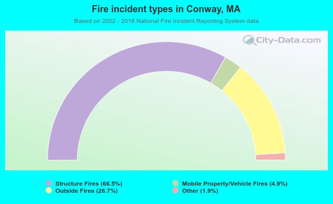 When looking into fire subcategories, the most reports belonged to: Structure Fires (66.5%), and Outside Fires (26.7%).
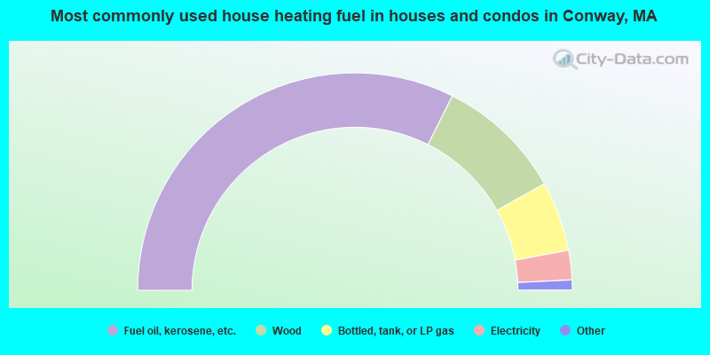
- 64.8%Fuel oil, kerosene, etc.
- 18.9%Wood
- 10.4%Bottled, tank, or LP gas
- 4.4%Electricity
- 1.0%Utility gas
- 0.5%Other fuel
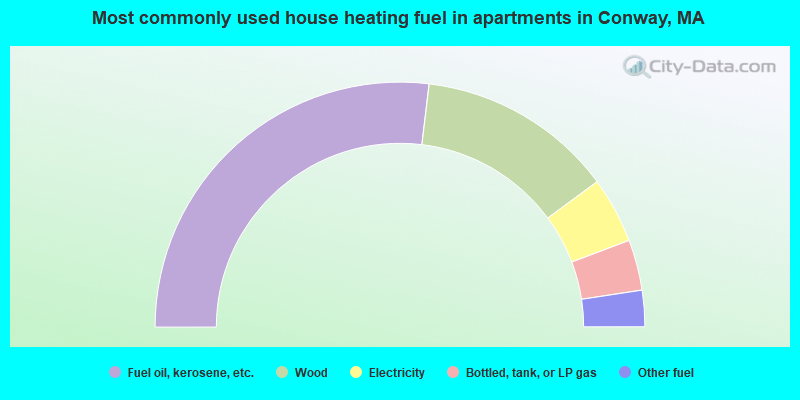
- 53.8%Fuel oil, kerosene, etc.
- 26.0%Wood
- 8.7%Electricity
- 6.7%Bottled, tank, or LP gas
- 4.8%Other fuel
Conway compared to Massachusetts state average:
- Unemployed percentage significantly below state average.
- Black race population percentage significantly below state average.
- Hispanic race population percentage significantly below state average.
- Median age above state average.
- Foreign-born population percentage significantly below state average.
- Renting percentage significantly below state average.
- Length of stay since moving in significantly above state average.
- Number of rooms per house significantly below state average.
- House age significantly below state average.

|
|
Total of 11 patent applications in 2008-2024.