Thurston, New York
Submit your own pictures of this town and show them to the world
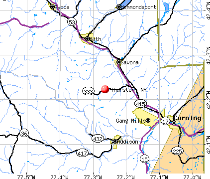
- OSM Map
- General Map
- Google Map
- MSN Map
Population change since 2000: +3.1%
 |
| Males: 683 | |
| Females: 667 |
| Median resident age: | 41.8 years |
| New York median age: | 40.7 years |
Zip codes: 14821.
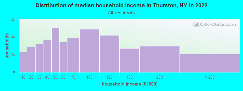
| Thurston: | $61,724 |
| NY: | $79,557 |
Estimated per capita income in 2022: $26,123 (it was $13,725 in 2000)
Thurston town income, earnings, and wages data
Estimated median house or condo value in 2022: $122,133 (it was $62,100 in 2000)
| Thurston: | $122,133 |
| NY: | $400,400 |
Mean prices in 2022: all housing units: $169,714; detached houses: $184,786; townhouses or other attached units: $138,888; in 2-unit structures: $291,252; in 3-to-4-unit structures: $333,918; in 5-or-more-unit structures: $308,305; mobile homes: $80,148; occupied boats, rvs, vans, etc.: $43,655
Detailed information about poverty and poor residents in Thurston, NY


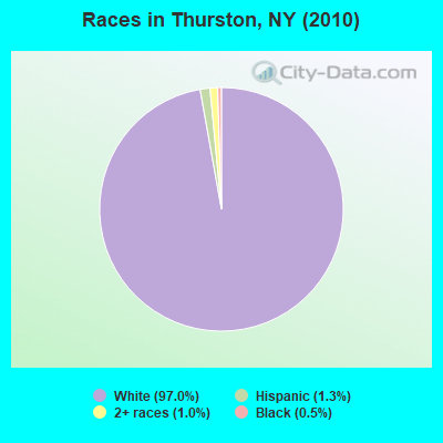
- 1,31097.0%White alone
- 181.3%Hispanic
- 131.0%Two or more races
- 70.5%Black alone
- 10.07%American Indian alone
- 10.07%Asian alone
Races in Thurston detailed stats: ancestries, foreign born residents, place of birth
 Recent articles from our blog. Our writers, many of them Ph.D. graduates or candidates, create easy-to-read articles on a wide variety of topics.

 | Auburn area development, events, news, etc. (253 replies) |
| Ideas for the economic growth and quality of life in Syracuse (334 replies) |
| First time visiting the Adirondacks? What to experience in this famous New York state park (172 replies) |
| Rochester-Boom or Bust (742 replies) |
| High Housing Costs Are Why People Are Leaving NYC (80 replies) |
| City starts planning to remove more of the Inner Loop (249 replies) |
Latest news from Thurston, NY collected exclusively by city-data.com from local newspapers, TV, and radio stations
Ancestries: German (14.4%), Irish (14.3%), English (12.5%), United States (10.3%), Dutch (5.2%), Italian (4.0%).
Current Local Time: EST time zone
Elevation: 1260 feet
Land area: 36.4 square miles.
Population density: 37 people per square mile (very low).
6 residents are foreign born
| This town: | 0.5% |
| New York: | 20.4% |
| Thurston town: | 1.8% ($1,134) |
| New York: | 1.9% ($2,847) |
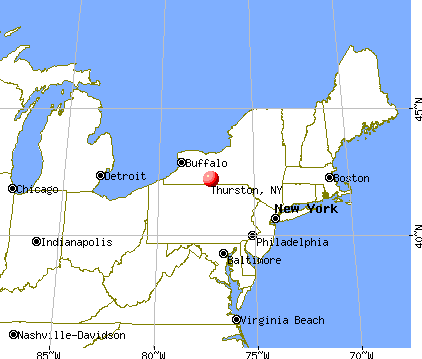
Nearest city with pop. 50,000+: Union, NY (64.8 miles  , pop. 56,298).
Nearest city with pop. 200,000+: Rochester, NY (67.2 miles , pop. 219,773).
Nearest city with pop. 1,000,000+: Philadelphia, PA (190.0 miles , pop. 1,517,550).
Nearest cities:
), ), ), ), )Latitude: 42.23 N, Longitude: 77.28 W
Area code commonly used in this area: 607

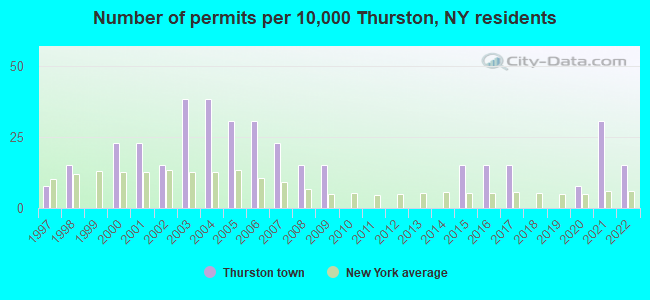
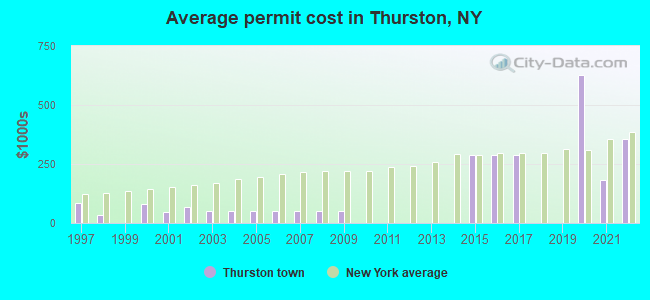
Single-family new house construction building permits:
- 2022: 2 buildings, average cost: $355,000
- 2021: 4 buildings, average cost: $184,000
- 2020: 1 building, cost: $627,000
- 2017: 2 buildings, average cost: $290,000
- 2016: 2 buildings, average cost: $290,000
- 2015: 2 buildings, average cost: $290,000
- 2009: 2 buildings, average cost: $48,600
- 2008: 2 buildings, average cost: $48,600
- 2007: 3 buildings, average cost: $48,600
- 2006: 4 buildings, average cost: $48,600
- 2005: 4 buildings, average cost: $48,600
- 2004: 5 buildings, average cost: $48,600
- 2003: 5 buildings, average cost: $48,600
- 2002: 2 buildings, average cost: $67,900
- 2001: 3 buildings, average cost: $47,800
- 2000: 3 buildings, average cost: $80,000
- 1998: 2 buildings, average cost: $35,000
- 1997: 1 building, cost: $85,000
| Here: | 4.5% |
| New York: | 4.4% |
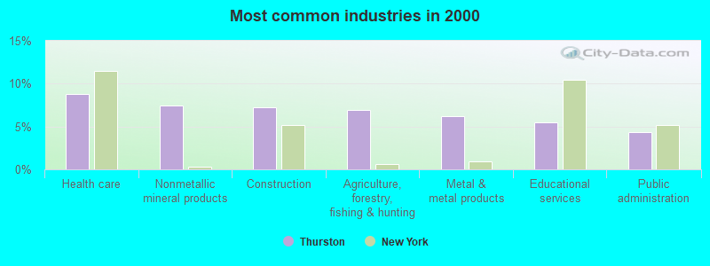
- Health care (8.8%)
- Nonmetallic mineral products (7.4%)
- Construction (7.3%)
- Agriculture, forestry, fishing & hunting (6.9%)
- Metal & metal products (6.2%)
- Educational services (5.5%)
- Public administration (4.3%)
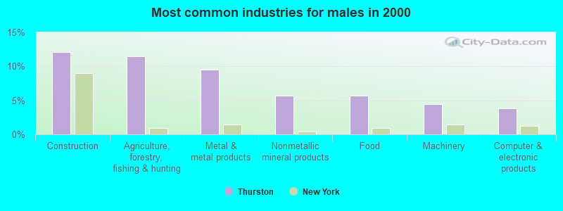
- Construction (12.1%)
- Agriculture, forestry, fishing & hunting (11.5%)
- Metal & metal products (9.6%)
- Nonmetallic mineral products (5.7%)
- Food (5.7%)
- Machinery (4.5%)
- Computer & electronic products (3.8%)
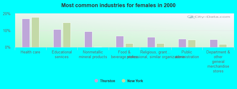
- Health care (17.0%)
- Educational services (10.6%)
- Nonmetallic mineral products (9.4%)
- Food & beverage stores (6.8%)
- Religious, grantmaking, civic, professional, similar organizations (6.0%)
- Public administration (4.9%)
- Department & other general merchandise stores (4.5%)
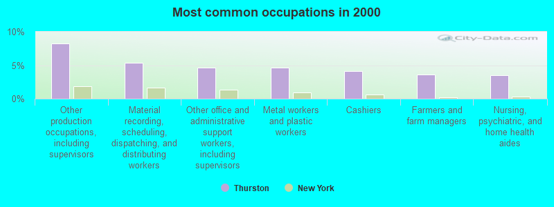
- Other production occupations, including supervisors (8.3%)
- Material recording, scheduling, dispatching, and distributing workers (5.4%)
- Other office and administrative support workers, including supervisors (4.7%)
- Metal workers and plastic workers (4.7%)
- Cashiers (4.1%)
- Farmers and farm managers (3.6%)
- Nursing, psychiatric, and home health aides (3.5%)
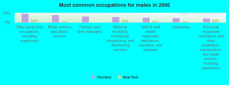
- Other production occupations, including supervisors (9.6%)
- Metal workers and plastic workers (8.3%)
- Farmers and farm managers (6.7%)
- Material recording, scheduling, dispatching, and distributing workers (6.1%)
- Vehicle and mobile equipment mechanics, installers, and repairers (5.4%)
- Carpenters (4.8%)
- Electrical equipment mechanics and other installation, maintenance, and repair workers, including supervisors (4.5%)
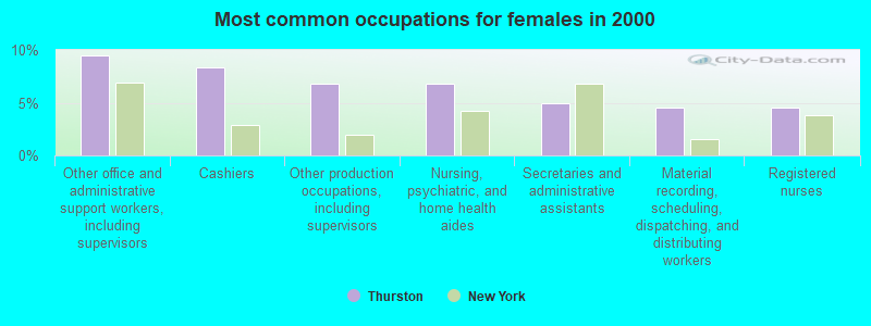
- Other office and administrative support workers, including supervisors (9.4%)
- Cashiers (8.3%)
- Other production occupations, including supervisors (6.8%)
- Nursing, psychiatric, and home health aides (6.8%)
- Secretaries and administrative assistants (4.9%)
- Material recording, scheduling, dispatching, and distributing workers (4.5%)
- Registered nurses (4.5%)
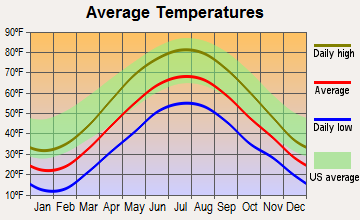
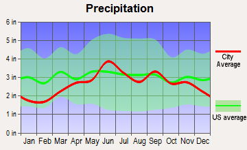
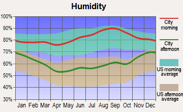
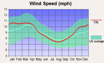
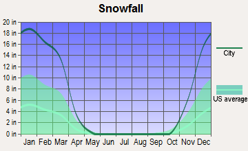
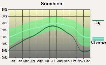
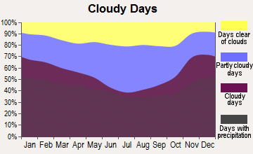
Average climate in Thurston, New York
Based on data reported by over 4,000 weather stations
(lower is better)
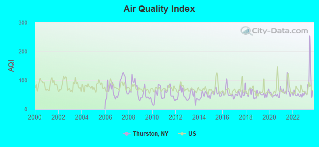
Air Quality Index (AQI) level in 2023 was 91.9. This is worse than average.
| City: | 91.9 |
| U.S.: | 72.6 |
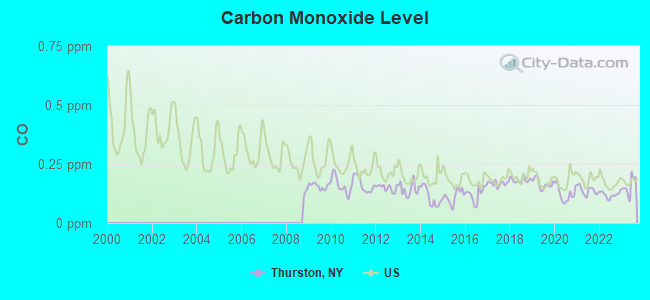
Carbon Monoxide (CO) [ppm] level in 2023 was 0.156. This is significantly better than average. Closest monitor was 9.9 miles away from the city center.
| City: | 0.156 |
| U.S.: | 0.251 |
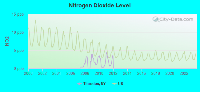
Nitrogen Dioxide (NO2) [ppb] level in 2011 was 2.25. This is significantly better than average. Closest monitor was 9.9 miles away from the city center.
| City: | 2.25 |
| U.S.: | 5.11 |
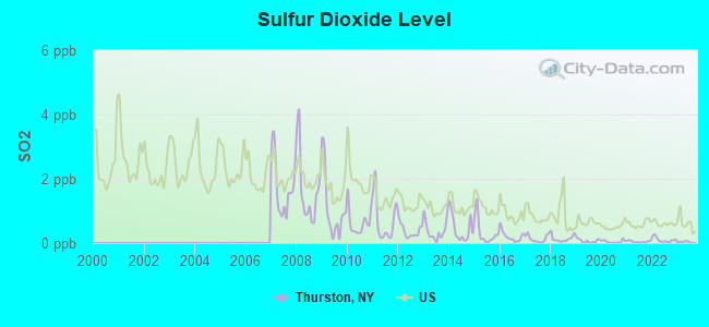
Sulfur Dioxide (SO2) [ppb] level in 2023 was 0.0309. This is significantly better than average. Closest monitor was 9.9 miles away from the city center.
| City: | 0.0309 |
| U.S.: | 1.5147 |
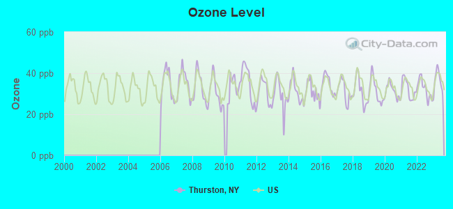
Ozone [ppb] level in 2023 was 35.9. This is about average. Closest monitor was 9.9 miles away from the city center.
| City: | 35.9 |
| U.S.: | 33.3 |
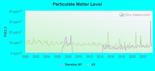
Particulate Matter (PM2.5) [µg/m3] level in 2023 was 9.50. This is about average. Closest monitor was 9.9 miles away from the city center.
| City: | 9.50 |
| U.S.: | 8.11 |
Tornado activity:
Thurston-area historical tornado activity is near New York state average. It is 64% smaller than the overall U.S. average.
On 8/30/1955, a category F3 (max. wind speeds 158-206 mph) tornado 19.7 miles away from the Thurston town center caused between $5000 and $50,000 in damages.
On 5/2/1983, a category F3 tornado 33.5 miles away from the town center injured 6 people and caused between $500,000 and $5,000,000 in damages.
Earthquake activity:
Thurston-area historical earthquake activity is significantly above New York state average. It is 66% smaller than the overall U.S. average.On 9/25/1998 at 19:52:52, a magnitude 5.2 (4.8 MB, 4.3 MS, 5.2 LG, 4.5 MW, Depth: 3.1 mi, Class: Moderate, Intensity: VI - VII) earthquake occurred 168.5 miles away from Thurston center
On 10/7/1983 at 10:18:46, a magnitude 5.3 (5.1 MB, 5.3 LG, 5.1 ML) earthquake occurred 190.4 miles away from Thurston center
On 8/23/2011 at 17:51:04, a magnitude 5.8 (5.8 MW, Depth: 3.7 mi) earthquake occurred 300.5 miles away from Thurston center
On 4/20/2002 at 10:50:47, a magnitude 5.3 (5.3 ML, Depth: 3.0 mi) earthquake occurred 239.6 miles away from Thurston center
On 4/20/2002 at 10:50:47, a magnitude 5.2 (5.2 MB, 4.2 MS, 5.2 MW, 5.0 MW) earthquake occurred 237.7 miles away from Thurston center
On 1/31/1986 at 16:46:43, a magnitude 5.0 (5.0 MB) earthquake occurred 204.4 miles away from the city center
Magnitude types: regional Lg-wave magnitude (LG), body-wave magnitude (MB), local magnitude (ML), surface-wave magnitude (MS), moment magnitude (MW)
Natural disasters:
The number of natural disasters in Steuben County (20) is greater than the US average (15).Major Disasters (Presidential) Declared: 16
Emergencies Declared: 4
Causes of natural disasters: Storms: 12, Floods: 10, Hurricanes: 2, Tornadoes: 2, Blizzard: 1, Flash Flood: 1, Heavy Rain: 1, Landslide: 1, Power Outage: 1, Tropical Depression: 1, Tropical Storm: 1, Wind: 1, Winter Storm: 1, Other: 1 (Note: some incidents may be assigned to more than one category).

Hospitals and medical centers near Thurston:
- PATHWAYS, INC (Hospital, about 8 miles away; PAINTED POST, NY)
- STEUBEN CO PUBLIC HLTH CHHA (Home Health Center, about 8 miles away; BATH, NY)
- BATH VA MEDICAL CENTER (Hospital, Acute Care - Veterans Administration, about 9 miles away; BATH, NY)
- PATHWAYS, INC (Hospital, about 10 miles away; PAINTED POST, NY)
- ABSOLUT CTR FOR NURSING AND REHAB THREE RIVERS L L C (Nursing Home, about 10 miles away; PAINTED POST, NY)
- CORNING HOSPITAL Acute Care Hospitals (about 14 miles away; CORNING, NY)
- PATHWAYS, INC (Hospital, about 15 miles away; CORNING, NY)
Colleges/universities with over 2000 students nearest to Thurston:
- Corning Community College (about 13 miles; Corning, NY; Full-time enrollment: 3,036)
- Alfred University (about 27 miles; Alfred, NY; FT enrollment: 2,411)
- SUNY College of Technology at Alfred (about 27 miles; Alfred, NY; FT enrollment: 3,483)
- Mansfield University of Pennsylvania (about 32 miles; Mansfield, PA; FT enrollment: 2,826)
- Ithaca College (about 43 miles; Ithaca, NY; FT enrollment: 6,781)
- Cornell University (about 44 miles; Ithaca, NY; FT enrollment: 20,360)
- Finger Lakes Community College (about 45 miles; Canandaigua, NY; FT enrollment: 4,732)
Points of interest:
Church in Thurston: Risingville Methodist Church (A). Display/hide its location on the map
Cemeteries: Bonny Hill Cemetery (1), Risingville Cemetery (2), Thurston Cemetery (3), Aldrich Cemetery (4). Display/hide their locations on the map
Lakes: Thurston Pond (A), Cranberry Pond (B). Display/hide their locations on the map
| This town: | 2.7 people |
| New York: | 2.6 people |
| This town: | 73.6% |
| Whole state: | 63.5% |
| This town: | 9.9% |
| Whole state: | 6.8% |
Likely homosexual households (counted as self-reported same-sex unmarried-partner households)
- Lesbian couples: 0.4% of all households
- Gay men: 0.0% of all households
| This town: | 12.1% |
| Whole state: | 14.6% |
| This town: | 4.8% |
| Whole state: | 7.4% |
For population 15 years and over in Thurston:
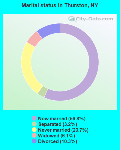
- Never married: 23.7%
- Now married: 56.8%
- Separated: 3.2%
- Widowed: 6.1%
- Divorced: 10.3%
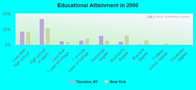
For population 25 years and over in Thurston:
- High school or higher: 78.1%
- Bachelor's degree or higher: 7.3%
- Graduate or professional degree: 1.8%
- Unemployed: 8.5%
- Mean travel time to work (commute): 25.7 minutes
| Here: | 9.6 |
| New York average: | 14.2 |
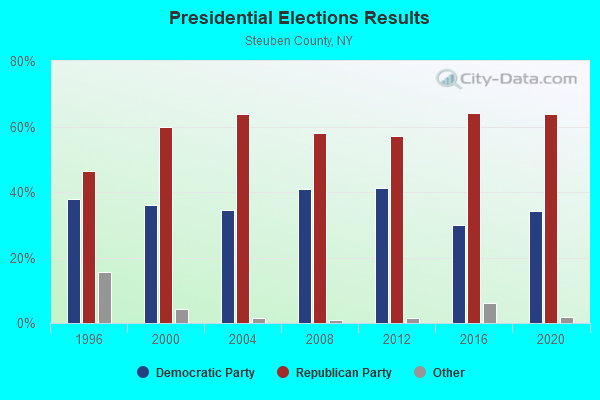
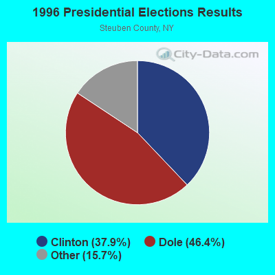
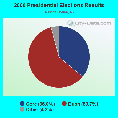
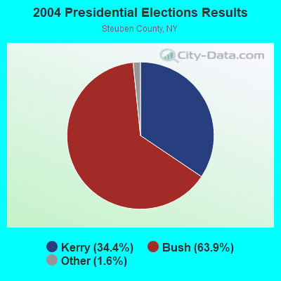
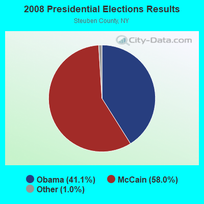
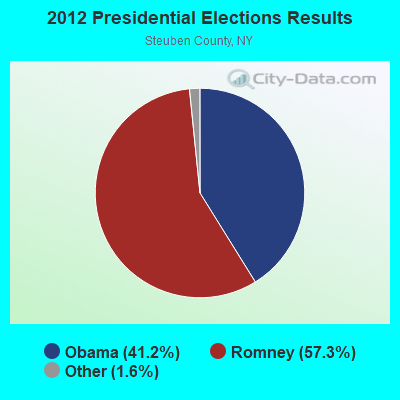
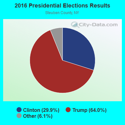
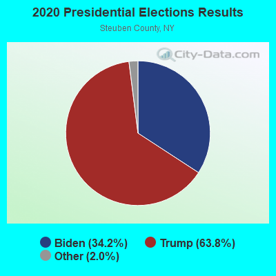
Graphs represent county-level data. Detailed 2008 Election Results
Religion statistics for Thurston, NY (based on Steuben County data)
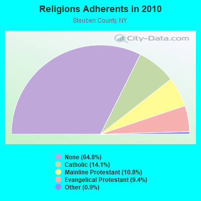
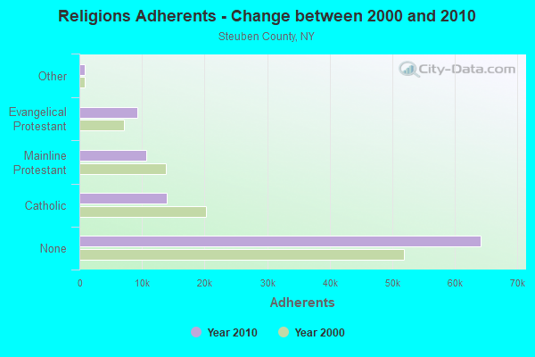
| Religion | Adherents | Congregations |
|---|---|---|
| Catholic | 13,963 | 11 |
| Mainline Protestant | 10,652 | 70 |
| Evangelical Protestant | 9,272 | 72 |
| Other | 857 | 8 |
| Orthodox | 65 | 1 |
| None | 64,181 | - |
Food Environment Statistics:
| Steuben County: | 2.48 / 10,000 pop. |
| New York: | 4.13 / 10,000 pop. |
| This county: | 0.10 / 10,000 pop. |
| New York: | 0.06 / 10,000 pop. |
| Here: | 0.72 / 10,000 pop. |
| New York: | 0.92 / 10,000 pop. |
| Steuben County: | 4.24 / 10,000 pop. |
| New York: | 1.68 / 10,000 pop. |
| Steuben County: | 9.00 / 10,000 pop. |
| New York: | 8.82 / 10,000 pop. |
| This county: | 10.2% |
| New York: | 8.2% |
| Steuben County: | 28.3% |
| New York: | 23.8% |
| Steuben County: | 14.2% |
| New York: | 15.6% |
Strongest AM radio stations in Thurston:
- WABH (1380 AM; 10 kW; BATH, NY)
- WHAM (1180 AM; 50 kW; ROCHESTER, NY; Owner: CITICASTERS LICENSES, L.P.)
- WLNL (1000 AM; daytime; 5 kW; HORSEHEADS, NY; Owner: LIGHTHOUSE MEDIA, INC.)
- WWLZ (820 AM; 4 kW; HORSEHEADS, NY; Owner: CHEMUNG COUNTY RADIO, INC.)
- WHHO (1320 AM; 5 kW; HORNELL, NY; Owner: BILBAT RADIO, INC.)
- WELM (1410 AM; 5 kW; ELMIRA, NY; Owner: PEMBROOK PINES ELMIRA, LIMITED)
- WEHH (1590 AM; 5 kW; ELMIRA HTS/HORSEHEAD, NY; Owner: PEMBROOK PINES ELMIRA, LTD.)
- WFLR (1570 AM; 5 kW; DUNDEE, NY; Owner: LAKES COUNTY COMMUNICATION CORP.)
- WLEA (1480 AM; 2 kW; HORNELL, NY; Owner: PMJ COMMUNICATIONS, INC.)
- WWKB (1520 AM; 50 kW; BUFFALO, NY; Owner: ENTERCOM BUFFALO LICENSE, LLC)
- WCBA (1350 AM; 1 kW; CORNING, NY)
- WCLI (1450 AM; 1 kW; CORNING, NY; Owner: EOLIN BROADCASTING, INC.)
- WPIE (1160 AM; 5 kW; TRUMANSBURG, NY; Owner: PEMBROOK PINES ITHACA LTD. N.A.)
Strongest FM radio stations in Thurston:
- WGMM (97.7 FM; BIG FLATS, NY; Owner: EOLIN BROADCASTING, INC.)
- WVIN-FM (98.3 FM; BATH, NY; Owner: PEMBROOK PINES MASS MEDIA, NA CORP.)
- WCBA-FM (98.7 FM; CORNING, NY; Owner: EOLIN BROADCASTING, INC.)
- WCIK (103.1 FM; BATH, NY; Owner: FAMILY LIFE MINISTRIES, INC.)
- WNKI (106.1 FM; CORNING, NY; Owner: CHEMUNG COUNTY RADIO, INC.)
- WMTT (94.7 FM; TIOGA, PA; Owner: EUROPA COMMUNICATIONS, INC.)
- W236AK (95.1 FM; CORNING, NY; Owner: EUROPA COMMUNICATIONS, INC.)
- WSQE (91.1 FM; CORNING, NY; Owner: WSKG PUB. TELECOMMUNICATIONS COUNCIL)
- WSQA (88.7 FM; HORNELL, NY; Owner: WSKG PUBLIC TELECOMMUNICATIONS COUNCIL)
- WOKN (99.5 FM; SOUTHPORT, NY; Owner: PEMBROOK PINES ELMIRA, LTD.)
- WLVY (94.3 FM; ELMIRA, NY; Owner: PEMBROOK PINES ELMIRA, LTD.)
- WCKR (92.1 FM; HORNELL, NY; Owner: PMJ COMMUNICATIONS, INC.)
- WZKZ (101.9 FM; ALFRED, NY; Owner: PEMBROOK PINES ELMIRA, LTD.)
- WKPQ (105.3 FM; HORNELL, NY; Owner: BILBAT RADIO, INC.)
- WDNY-FM (93.9 FM; DANSVILLE, NY; Owner: MILLER MEDIA INC.)
- WNBQ (92.3 FM; MANSFIELD, PA; Owner: FARM & HOME BROADCASTING COMPANY)
- WCIY (88.9 FM; CANANDAIGUA, NY; Owner: FAMILY LIFE MINISTRIES, INC.)
- WNGZ (104.9 FM; MONTOUR FALLS, NY; Owner: CHEMUNG COUNTY RADIO, INC.)
- WQNY (103.7 FM; ITHACA, NY; Owner: EAGLE II BROADCASTING CORPORATION)
- WENY-FM (92.7 FM; ELMIRA, NY; Owner: EOLIN BROADCASTING, INC.)
TV broadcast stations around Thurston:
- W60AD (Channel 60; SAVONA, NY; Owner: WSKG PUBLIC TELECOMMUNICATIONS COUNCIL)
- W20BL (Channel 20; BATH, NY; Owner: WYDC, INC.)
- WYDC (Channel 48; CORNING, NY; Owner: WYDC, INC.)
- WETM-TV (Channel 18; ELMIRA, NY; Owner: SMITH TELEVISION OF NEW YORK LICENSE HOLDINGS, INC.)
- W26BF (Channel 26; ELMIRA, NY; Owner: WYDC, INC.)
- WENY-TV (Channel 36; ELMIRA, NY; Owner: LILLY BROADCASTING, L.L.C.)
- W21BW (Channel 21; ELMIRA, NY; Owner: THREE ANGELS BROADCASTING NETWORK INC.)
- W16BE (Channel 16; HORNELL, NY; Owner: WYDC, INC.)
- W59DG (Channel 59; ELMIRA, NY; Owner: TRINITY BROADCASTING NETWORK)
- National Bridge Inventory (NBI) Statistics
- 5Number of bridges
- 20ft / 5.5mTotal length
- $2,089,000Total costs
- 2,577Total average daily traffic
- 192Total average daily truck traffic
- 3,387Total future (year 2038) average daily traffic
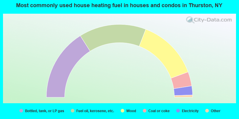
- 32.0%Bottled, tank, or LP gas
- 29.7%Fuel oil, kerosene, etc.
- 27.0%Wood
- 6.3%Coal or coke
- 4.0%Electricity
- 0.5%Utility gas
- 0.5%Other fuel
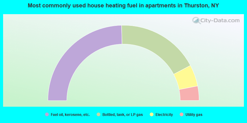
- 49.2%Fuel oil, kerosene, etc.
- 35.4%Bottled, tank, or LP gas
- 9.2%Electricity
- 6.2%Utility gas
Thurston compared to New York state average:
- Median house value significantly below state average.
- Unemployed percentage below state average.
- Black race population percentage significantly below state average.
- Hispanic race population percentage significantly below state average.
- Foreign-born population percentage significantly below state average.
- Renting percentage significantly below state average.
- Length of stay since moving in significantly above state average.
- Number of rooms per house significantly below state average.
- House age significantly below state average.
- Number of college students below state average.
- Percentage of population with a bachelor's degree or higher significantly below state average.