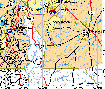
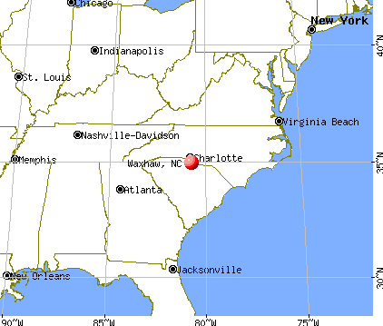
Waxhaw, North Carolina
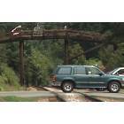
Waxhaw: Historic Bridge, Railway, & Highways all meet at Crossroads in Historic Downtown Waxhaw, NC
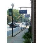
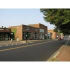
Waxhaw: South Main Sidewalk View in Historic Downtown Waxhaw, NC
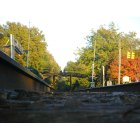
Waxhaw: Train Tracks
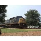
Waxhaw: Trains run thru the center of Historic Downtown Waxhaw, NC

Waxhaw: Twelve Mile Creek - Waxhax, NC January 2009

Waxhaw: Train
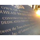
Waxhaw: Town of Waxhaw Plaque
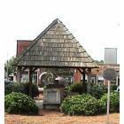
Waxhaw: Town Center Gazebo/Wishing Well in Historic Downtown Waxhaw, NC
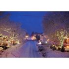
Waxhaw: Waxhaw Winter of 2011
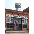
Waxhaw: Antique Depot & Historic Water Tower of Waxhaw, NC
Waxhaw: Downtown Waxhaw
- see
13
more - add
your
Submit your own pictures of this town and show them to the world
- OSM Map
- General Map
- Google Map
- MSN Map
Population change since 2000: +758.4%
| Males: 10,992 | |
| Females: 11,541 |
| Median resident age: | 36.2 years |
| North Carolina median age: | 39.2 years |
Zip codes: 28173.
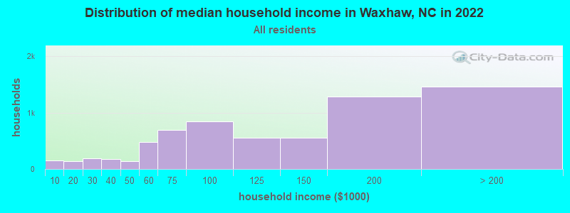
| Waxhaw: | $122,929 |
| NC: | $67,481 |
Estimated per capita income in 2022: $44,059 (it was $23,481 in 2000)
Waxhaw town income, earnings, and wages data
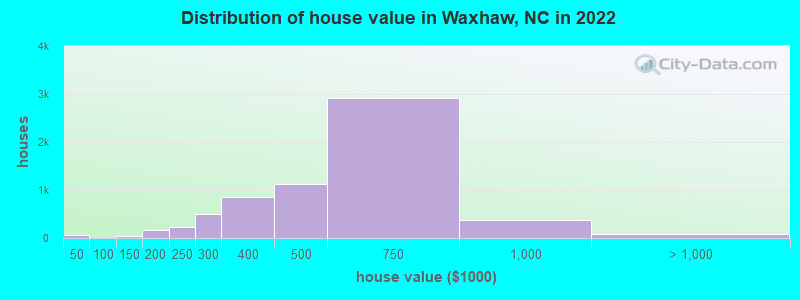
Estimated median house or condo value in 2022: $544,761 (it was $133,700 in 2000)
| Waxhaw: | $544,761 |
| NC: | $280,600 |
Mean prices in 2022: all housing units: $377,302; detached houses: $381,016; townhouses or other attached units: $244,366; in 5-or-more-unit structures: $211,533; mobile homes: $126,542
Median gross rent in 2022: $2,017.
(3.0% for White Non-Hispanic residents, 12.1% for Black residents, 14.0% for Hispanic or Latino residents)
Detailed information about poverty and poor residents in Waxhaw, NC


Compare current foreclosures near Waxhaw, NC:
| Photo | Address | Area | Beds / Baths | Price | Details |
|---|---|---|---|---|---|

|
#1
Grover Rogers Rd
Waxhaw, NC 28173
|
1,511 sq. feet
|
2 baths 3 beds |
show details | |

|
#2
Spruce Pine Trl
Waxhaw, NC 28173
|
1,559 sq. feet
|
1 baths 2 beds |
show details | |

|
#3
Sturminster Dr
Waxhaw, NC 28173
|
4,643 sq. feet
|
2 baths 4 beds |
show details | |

|
#4
Hamil Ridge Dr
Waxhaw, NC 28173
|
3,173 sq. feet
|
1 baths 4 beds |
show details | |

|
#5
Royal Colony Dr
Waxhaw, NC 28173
|
2,811 sq. feet
|
1 baths 4 beds |
show details | |

|
#6
Peppergrass Ln
Waxhaw, NC 28173
|
3,404 sq. feet
|
2 baths 4 beds |
show details | |

|
#7
Peyton Ct
Waxhaw, NC 28173
|
1,300 sq. feet
|
1 baths 3 beds |
show details | |

|
#8
Harrison Park Dr
Waxhaw, NC 28173
|
1,334 sq. feet
|
2 baths 3 beds |
show details | |

|
#9
Sandtyn Dr
Waxhaw, NC 28173
|
2,612 sq. feet
|
- baths 5 beds |
show details | |

|
#10
Mccain Blvd
Waxhaw, NC 28173
|
1,568 sq. feet
|
1 baths - beds |
show details |
| Photo | Address | Area | Beds / Baths | Price | Details |
|---|---|---|---|---|---|

|
#11
Waxhaw Creek Rd
Waxhaw, NC 28173
|
1,056 sq. feet
|
1 baths - beds |
show details | |

|
#12
Glenda Drive
Waxhaw, NC 28173
|
- sq. feet
|
- baths - beds |
show details | |

|
#13
Union Central Ct
Waxhaw, NC 28173
|
- sq. feet
|
- baths - beds |
show details | |

|
#14
Wynhurst Dr
Waxhaw, NC 28173
|
- sq. feet
|
- baths - beds |
show details | |

|
#15
Wesley Glen Dr
Waxhaw, NC 28173
|
- sq. feet
|
- baths - beds |
show details | |

|
#16
Wall St
Waxhaw, NC 28173
|
- sq. feet
|
- baths - beds |
show details | |

|
#17
Barra Dr
Waxhaw, NC 28173
|
- sq. feet
|
- baths - beds |
show details | |

|
#18
Deep River Way
Waxhaw, NC 28173
|
- sq. feet
|
- baths - beds |
show details | |

|
#19
Oakhurst Dr
Waxhaw, NC 28173
|
- sq. feet
|
- baths - beds |
show details | |

|
#20
Glenwood Dr
Waxhaw, NC 28173
|
- sq. feet
|
- baths - beds |
show details |
| Photo | Address | Area | Beds / Baths | Price | Details |
|---|---|---|---|---|---|

|
#21
Elmhurst Dr
Waxhaw, NC 28173
|
- sq. feet
|
- baths - beds |
show details | |

|
#22
Belle Arbor Dr
Waxhaw, NC 28173
|
- sq. feet
|
- baths - beds |
show details | |

|
#23
W Franklin St
Monroe, NC 28112
|
2,107 sq. feet
|
2 baths 3 beds |
$254,900
|
show details |

|
#24
Silverwood Dr
Waxhaw, NC 28173
|
- sq. feet
|
- baths - beds |
show details | |

|
#25
Richardson King Rd
Waxhaw, NC 28173
|
- sq. feet
|
- baths - beds |
show details | |

|
#26
Kelly Lynn Ct
Waxhaw, NC 28173
|
- sq. feet
|
- baths - beds |
show details | |

|
#27
Sand Dollar Ct
Monroe, NC 28112
|
1,456 sq. feet
|
2 baths 3 beds |
show details | |

|
#28
Confederate Ave
Lancaster, SC 29720
|
1,147 sq. feet
|
2 baths 3 beds |
show details | |

|
#29
Crawford Rd
Rock Hill, SC 29730
|
1,163 sq. feet
|
1 baths 2 beds |
show details | |

|
#30
State Street Ext
Rock Hill, SC 29730
|
1,078 sq. feet
|
1 baths 1 beds |
show details |
| Photo | Address | Area | Beds / Baths | Price | Details |
|---|---|---|---|---|---|

|
#31
Andora Dr
Rock Hill, SC 29732
|
1,232 sq. feet
|
2 baths 3 beds |
show details | |

|
#32
Margaret St
Rock Hill, SC 29730
|
2,328 sq. feet
|
2 baths 4 beds |
show details | |

|
#33
N Ferguson St
Lancaster, SC 29720
|
729 sq. feet
|
1 baths 2 beds |
show details | |

|
#34
Londontowne Dr
Charlotte, NC 28226
|
1,800 sq. feet
|
3 baths 4 beds |
show details | |

|
#35
Pearl Dr
Lancaster, SC 29720
|
2,128 sq. feet
|
2 baths 3 beds |
show details | |

|
#36
Tradd Cir
Monroe, NC 28110
|
2,016 sq. feet
|
2 baths 2 beds |
show details | |

|
#37
Whitefriars Ln
Matthews, NC 28105
|
1,864 sq. feet
|
2 baths 3 beds |
show details | |

|
#38
Windy Knoll Ln
Charlotte, NC 28227
|
3,731 sq. feet
|
5 baths 4 beds |
show details | |

|
#39
Timber Falls Dr
Fort Mill, SC 29707
|
2,984 sq. feet
|
2 baths 4 beds |
show details | |

|
#40
Trinity Trace Ln
Monroe, NC 28110
|
3,820 sq. feet
|
4 baths 5 beds |
show details |
| Photo | Address | Area | Beds / Baths | Price | Details |
|---|---|---|---|---|---|

|
#41
Glouchester Cir
Charlotte, NC 28226
|
1,640 sq. feet
|
2 baths 3 beds |
show details | |

|
#42
White Cliffs Dr
Monroe, NC 28110
|
1,147 sq. feet
|
2 baths 3 beds |
show details | |

|
#43
Vista Grande Cir
Charlotte, NC 28226
|
1,575 sq. feet
|
2 baths 3 beds |
show details | |

|
#44
W Sandy Ridge Rd
Monroe, NC 28112
|
1,008 sq. feet
|
1 baths 3 beds |
show details | |

|
#45
Stevens Rdg
Matthews, NC 28105
|
3,888 sq. feet
|
3 baths 4 beds |
show details | |

|
#46
Brianton Pl
Charlotte, NC 28226
|
3,007 sq. feet
|
3 baths 4 beds |
show details | |

|
#47
Painted Tree Rd
Charlotte, NC 28226
|
1,906 sq. feet
|
2 baths 3 beds |
show details | |

|
#48
Tranquil Cove Ct
Matthews, NC 28105
|
1,657 sq. feet
|
2 baths 3 beds |
show details | |

|
#49
Nightingale Ln
Charlotte, NC 28226
|
1,680 sq. feet
|
2 baths 3 beds |
show details | |

|
Check over 1 million property listings on Foreclosure.com!
|
browse all offers | |||


- 14,75168.8%White alone
- 2,28710.7%Hispanic
- 1,5927.4%Black alone
- 1,5307.1%Asian alone
- 1,1425.3%Two or more races
- 3421.6%Other race alone
- 120.06%American Indian alone
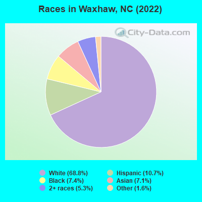
Races in Waxhaw detailed stats: ancestries, foreign born residents, place of birth
According to our research of North Carolina and other state lists, there were 34 registered sex offenders living in Waxhaw, North Carolina as of April 27, 2024.
The ratio of all residents to sex offenders in Waxhaw is 372 to 1.
Type |
2009 |
2010 |
2011 |
2012 |
2013 |
2014 |
2015 |
2016 |
2017 |
2018 |
2019 |
2020 |
2021 |
2022 |
|---|---|---|---|---|---|---|---|---|---|---|---|---|---|---|
| Murders (per 100,000) | 0 (0.0) | 0 (0.0) | 0 (0.0) | 0 (0.0) | 0 (0.0) | 1 (8.6) | 0 (0.0) | 0 (0.0) | 0 (0.0) | 0 (0.0) | 0 (0.0) | 0 (0.0) | 0 (0.0) | 0 (0.0) |
| Rapes (per 100,000) | 0 (0.0) | 1 (10.1) | 4 (40.1) | 1 (9.8) | 1 (9.5) | 0 (0.0) | 2 (14.7) | 1 (7.0) | 3 (19.9) | 1 (6.2) | 5 (29.1) | 5 (27.4) | 5 (26.2) | 7 (31.0) |
| Robberies (per 100,000) | 0 (0.0) | 2 (20.3) | 1 (10.0) | 2 (19.7) | 2 (19.1) | 1 (8.6) | 3 (22.1) | 3 (20.9) | 2 (13.3) | 3 (18.6) | 4 (23.3) | 1 (5.5) | 1 (5.2) | 1 (4.4) |
| Assaults (per 100,000) | 0 (0.0) | 8 (81.1) | 18 (180.3) | 11 (108.2) | 12 (114.5) | 5 (42.8) | 5 (36.8) | 16 (111.4) | 12 (79.5) | 7 (43.4) | 17 (98.8) | 4 (22.0) | 10 (52.4) | 11 (48.6) |
| Burglaries (per 100,000) | 13 (341.4) | 29 (294.1) | 51 (510.8) | 68 (668.8) | 27 (257.6) | 25 (214.1) | 33 (242.8) | 35 (243.6) | 26 (172.3) | 58 (360.0) | 46 (267.4) | 27 (148.2) | 21 (110.0) | 16 (70.8) |
| Thefts (per 100,000) | 16 (420.2) | 122 (1,237) | 137 (1,372) | 222 (2,184) | 130 (1,240) | 96 (822.1) | 71 (522.3) | 109 (758.7) | 142 (941.1) | 118 (732.4) | 107 (622.0) | 142 (779.3) | 117 (612.9) | 143 (632.4) |
| Auto thefts (per 100,000) | 1 (26.3) | 4 (40.6) | 4 (40.1) | 3 (29.5) | 4 (38.2) | 0 (0.0) | 1 (7.4) | 1 (7.0) | 2 (13.3) | 3 (18.6) | 3 (17.4) | 5 (27.4) | 8 (41.9) | 7 (31.0) |
| Arson (per 100,000) | 0 (0.0) | 1 (10.1) | 3 (30.0) | 1 (9.8) | 0 (0.0) | 1 (8.6) | 0 (0.0) | 0 (0.0) | 0 (0.0) | 2 (12.4) | 0 (0.0) | 1 (5.5) | 1 (5.2) | 0 (0.0) |
| City-Data.com crime index | 42.8 | 103.8 | 165.0 | 171.9 | 107.0 | 76.1 | 64.2 | 82.1 | 86.6 | 75.2 | 95.0 | 71.7 | 68.6 | 68.5 |
The City-Data.com crime index weighs serious crimes and violent crimes more heavily. Higher means more crime, U.S. average is 246.1. It adjusts for the number of visitors and daily workers commuting into cities.
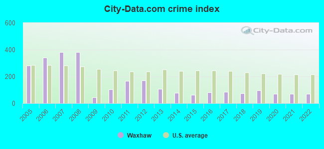
Crime rate in Waxhaw detailed stats: murders, rapes, robberies, assaults, burglaries, thefts, arson
Full-time law enforcement employees in 2021, including police officers: 32 (30 officers - 29 male; 1 female).
| Officers per 1,000 residents here: | 1.57 |
| North Carolina average: | 2.27 |
 Recent articles from our blog. Our writers, many of them Ph.D. graduates or candidates, create easy-to-read articles on a wide variety of topics.


Latest news from Waxhaw, NC collected exclusively by city-data.com from local newspapers, TV, and radio stations
Waxhaw, NC City Guides:
Ancestries: Italian (12.4%), English (9.1%), American (8.0%), Irish (5.3%), Brazilian (5.0%), Ukrainian (4.7%).
Current Local Time: EST time zone
Elevation: 664 feet
Land area: 2.82 square miles.
Population density: 8,004 people per square mile (high).
2,931 residents are foreign born (4.9% Latin America, 4.7% Asia, 2.7% Europe).
| This town: | 13.7% |
| North Carolina: | 8.3% |
Median real estate property taxes paid for housing units with mortgages in 2022: $3,399 (0.6%)
Median real estate property taxes paid for housing units with no mortgage in 2022: $4,167 (0.7%)
Nearest city with pop. 50,000+: Charlotte, NC  (19.9 miles , pop. 540,828).
Nearest city with pop. 1,000,000+: Philadelphia, PA (466.1 miles , pop. 1,517,550).
Nearest cities:
), ), ), ), ), Latitude: 34.93 N, Longitude: 80.74 W
Area code: 704
Waxhaw, North Carolina accommodation & food services, waste management - Economy and Business Data
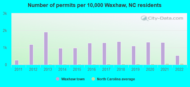
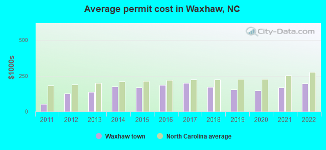
Single-family new house construction building permits:
- 2022: 143 buildings, average cost: $197,700
- 2021: 344 buildings, average cost: $169,600
- 2020: 348 buildings, average cost: $147,600
- 2019: 289 buildings, average cost: $153,800
- 2018: 355 buildings, average cost: $171,900
- 2017: 336 buildings, average cost: $199,700
- 2016: 334 buildings, average cost: $186,800
- 2015: 259 buildings, average cost: $167,200
- 2014: 252 buildings, average cost: $175,000
- 2013: 501 buildings, average cost: $137,500
- 2012: 312 buildings, average cost: $126,100
- 2011: 70 buildings, average cost: $51,800
| Here: | 2.8% |
| North Carolina: | 3.2% |
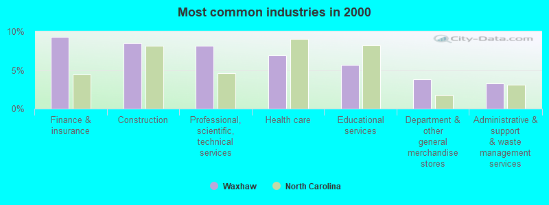
- Finance & insurance (9.3%)
- Construction (8.5%)
- Professional, scientific, technical services (8.2%)
- Health care (6.9%)
- Educational services (5.7%)
- Department & other general merchandise stores (3.8%)
- Administrative & support & waste management services (3.2%)
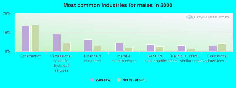
- Construction (13.7%)
- Professional, scientific, technical services (9.4%)
- Finance & insurance (6.4%)
- Metal & metal products (4.4%)
- Repair & maintenance (3.8%)
- Religious, grantmaking, civic, professional, similar organizations (3.1%)
- Educational services (3.0%)
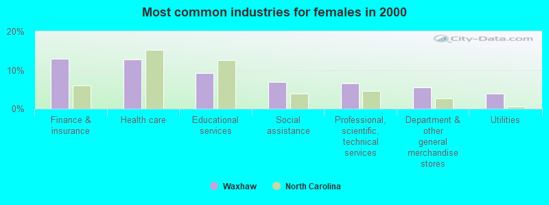
- Finance & insurance (13.0%)
- Health care (12.7%)
- Educational services (9.1%)
- Social assistance (6.9%)
- Professional, scientific, technical services (6.6%)
- Department & other general merchandise stores (5.4%)
- Utilities (3.9%)
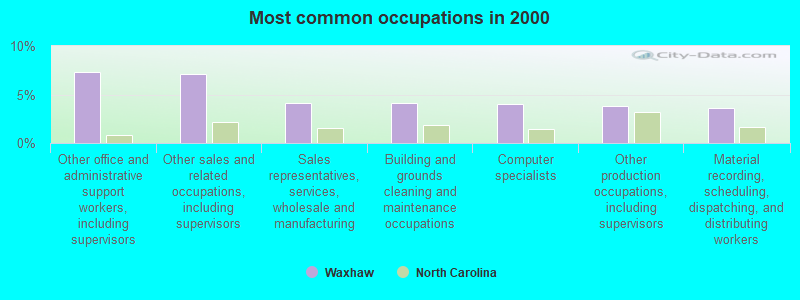
- Other office and administrative support workers, including supervisors (7.4%)
- Other sales and related occupations, including supervisors (7.1%)
- Sales representatives, services, wholesale and manufacturing (4.1%)
- Building and grounds cleaning and maintenance occupations (4.1%)
- Computer specialists (4.0%)
- Other production occupations, including supervisors (3.8%)
- Material recording, scheduling, dispatching, and distributing workers (3.6%)
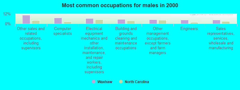
- Other sales and related occupations, including supervisors (10.7%)
- Computer specialists (7.2%)
- Electrical equipment mechanics and other installation, maintenance, and repair workers, including supervisors (6.4%)
- Building and grounds cleaning and maintenance occupations (5.6%)
- Other management occupations, except farmers and farm managers (4.9%)
- Engineers (4.8%)
- Sales representatives, services, wholesale and manufacturing (4.7%)
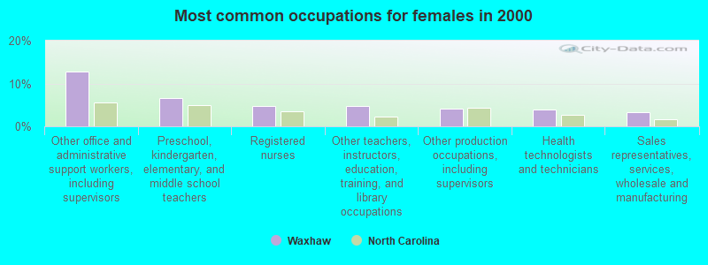
- Other office and administrative support workers, including supervisors (12.8%)
- Preschool, kindergarten, elementary, and middle school teachers (6.6%)
- Registered nurses (4.7%)
- Other teachers, instructors, education, training, and library occupations (4.7%)
- Other production occupations, including supervisors (4.2%)
- Health technologists and technicians (3.9%)
- Sales representatives, services, wholesale and manufacturing (3.4%)
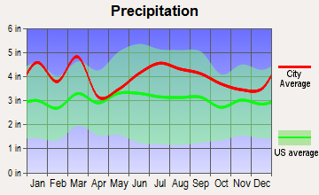
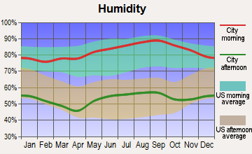
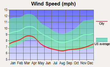
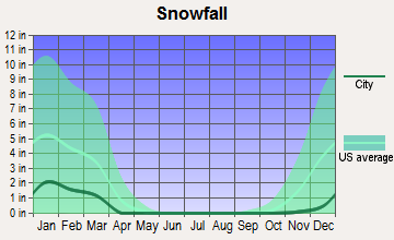
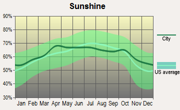
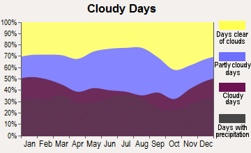
Average climate in Waxhaw, North Carolina
Based on data reported by over 4,000 weather stations

|
|

(lower is better)
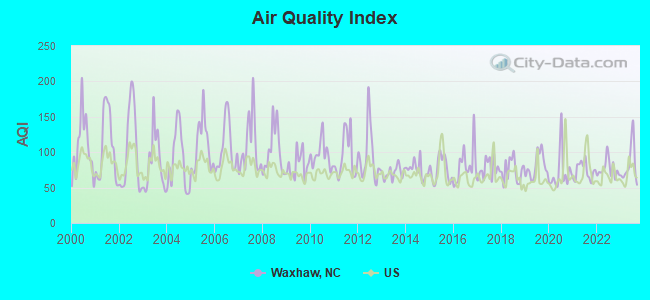
Air Quality Index (AQI) level in 2023 was 82.6. This is about average.
| City: | 82.6 |
| U.S.: | 72.6 |
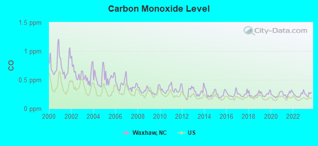
Carbon Monoxide (CO) [ppm] level in 2023 was 0.252. This is about average. Closest monitor was 14.7 miles away from the city center.
| City: | 0.252 |
| U.S.: | 0.251 |
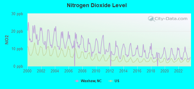
Nitrogen Dioxide (NO2) [ppb] level in 2023 was 5.50. This is about average. Closest monitor was 13.1 miles away from the city center.
| City: | 5.50 |
| U.S.: | 5.11 |
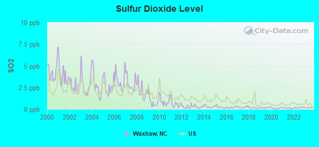
Sulfur Dioxide (SO2) [ppb] level in 2023 was 0.187. This is significantly better than average. Closest monitor was 7.4 miles away from the city center.
| City: | 0.187 |
| U.S.: | 1.515 |
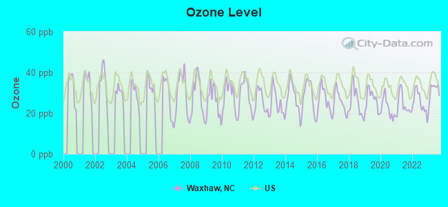
Ozone [ppb] level in 2023 was 30.9. This is about average. Closest monitor was 7.4 miles away from the city center.
| City: | 30.9 |
| U.S.: | 33.3 |
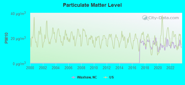
Particulate Matter (PM10) [µg/m3] level in 2023 was 14.3. This is better than average. Closest monitor was 14.7 miles away from the city center.
| City: | 14.3 |
| U.S.: | 19.2 |
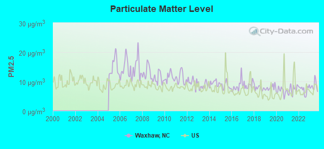
Particulate Matter (PM2.5) [µg/m3] level in 2023 was 8.46. This is about average. Closest monitor was 7.4 miles away from the city center.
| City: | 8.46 |
| U.S.: | 8.11 |
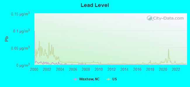
Lead (Pb) [µg/m3] level in 2007 was 0.00085. This is significantly better than average. Closest monitor was 14.7 miles away from the city center.
| City: | 0.00085 |
| U.S.: | 0.00931 |
Tornado activity:
Waxhaw-area historical tornado activity is slightly above North Carolina state average. It is 23% greater than the overall U.S. average.
On 5/5/1989, a category F4 (max. wind speeds 207-260 mph) tornado 3.7 miles away from the Waxhaw town center killed one person and injured 6 people and caused between $5,000,000 and $50,000,000 in damages.
On 4/8/1957, a category F4 tornado 22.7 miles away from the town center killed 4 people and injured 70 people.
Earthquake activity:
Waxhaw-area historical earthquake activity is significantly above North Carolina state average. It is 24% smaller than the overall U.S. average.On 8/9/2020 at 12:07:37, a magnitude 5.1 (5.1 MW, Depth: 4.7 mi, Class: Moderate, Intensity: VI - VII) earthquake occurred 108.8 miles away from Waxhaw center
On 8/23/2011 at 17:51:04, a magnitude 5.8 (5.8 MW, Depth: 3.7 mi) earthquake occurred 258.7 miles away from the city center
On 8/2/1974 at 08:52:09, a magnitude 4.9 (4.3 MB, 4.9 LG, Class: Light, Intensity: IV - V) earthquake occurred 123.4 miles away from the city center
On 11/22/1974 at 05:25:55, a magnitude 4.7 (4.7 MB) earthquake occurred 144.4 miles away from the city center
On 4/13/1998 at 09:56:11, a magnitude 3.9 (3.5 MB, 3.9 LG, Depth: 3.1 mi, Class: Light, Intensity: II - III) earthquake occurred 27.1 miles away from Waxhaw center
On 11/30/1973 at 07:48:41, a magnitude 4.7 (4.7 MB, 4.6 ML) earthquake occurred 191.2 miles away from Waxhaw center
Magnitude types: regional Lg-wave magnitude (LG), body-wave magnitude (MB), local magnitude (ML), moment magnitude (MW)
Natural disasters:
The number of natural disasters in Union County (12) is smaller than the US average (15).Major Disasters (Presidential) Declared: 7
Emergencies Declared: 3
Causes of natural disasters: Hurricanes: 5, Blizzard: 1, Drought: 1, Ice Storm: 1, Tornado: 1, Tropical Storm: 1, Winter Storm: 1, Other: 1 (Note: some incidents may be assigned to more than one category).
Hospitals and medical centers in Waxhaw:
Other hospitals and medical centers near Waxhaw:
- CENTRAL CAROLINAS REHAB COMPLEX (Nursing Home, about 6 miles away; LANCASTER, SC)
- KAREN LANE HOME (Hospital, about 7 miles away; MONROE, NC)
- UNION REGIONAL HOME CARE (Home Health Center, about 12 miles away; MONROE, NC)
- LAKE PARK NURSING AND REHABILITATION CENTER (Nursing Home, about 12 miles away; INDIAN TRAIL, NC)
- GENTIVA HEALTH SERVICES (Home Health Center, about 13 miles away; CHARLOTTE, NC)
- SOUTH CHARLOTTE DIALYSIS (Dialysis Facility, about 13 miles away; CHARLOTTE, NC)
- KINDRED TRANSITIONAL CARE AND REHAB-MONROE (Nursing Home, about 13 miles away; MONROE, NC)
Airports and heliports located in Waxhaw:
- Jaars-Townsend Airport (N52) (Runways: 1, Air Taxi Ops: 135, Itinerant Ops: 1,000, Local Ops: 12,000)
- Hawk's Knoll Airport (2NC1) (Runways: 1)
- Hawks Meadow Airport (07NC) (Runways: 1)
- Cmc Waxhaw Heliport (20NR)
Colleges/universities with over 2000 students nearest to Waxhaw:
- York Technical College (about 15 miles; Rock Hill, SC; Full-time enrollment: 3,572)
- Winthrop University (about 17 miles; Rock Hill, SC; FT enrollment: 5,575)
- Wingate University (about 18 miles; Wingate, NC; FT enrollment: 2,125)
- Queens University of Charlotte (about 19 miles; Charlotte, NC; FT enrollment: 2,083)
- Central Piedmont Community College (about 21 miles; Charlotte, NC; FT enrollment: 15,371)
- Johnson & Wales University-Charlotte (about 22 miles; Charlotte, NC; FT enrollment: 2,518)
- University of North Carolina at Charlotte (about 27 miles; Charlotte, NC; FT enrollment: 22,807)
Public high schools in Waxhaw:
- SOUTH PROVIDENCE (Location: 500 SOUTH PROVIDENCE STREET, Grades: 6-12)
- MARVIN RIDGE HIGH (Location: 2825 CRANE ROAD, Grades: 9-12)
- CUTHBERTSON HIGH (Location: 1400 CUTHBERTSON RD, Grades: 9-12)
Public elementary/middle schools in Waxhaw:
- WAXHAW ELEMENTARY (Location: 1101 OLD PROVIDENCE RD, Grades: PK-5)
- WESTERN UNION ELEMENTARY (Location: 4111 WESTERN UNION SCH RD, Grades: KG-5)
- KENSINGTON ELEMENTARY (Location: 8701 KENSINGTON DRIVE, Grades: KG-5)
- SANDY RIDGE ELEMENTARY (Location: 10101 WAXHAW MANOR DRIVE, Grades: KG-5)
- REA VIEW ELEMENTARY (Location: 320 REID DAIRY ROAD, Grades: KG-5)
- NEW TOWN ELEMENTARY (Location: 1100 WAXHAW-INDIAN TR. RD., Grades: PK-5)
- MARVIN RIDGE MIDDLE (Location: 2831 CRANE ROAD, Grades: 6-8)
- CUTHBERTSON MIDDLE (Location: 1520 CUTHBERTSON RD, Grades: 6-8)
Points of interest:
Churches in Waxhaw include: Price Chapel (A), Providence Church (B). Display/hide their locations on the map
Creek: Blythe Creek (A). Display/hide its location on the map
Tourist attraction: Pony Rides Etc (Petting Zoos; 625 Pacer Ln).
Birthplace of: Daniel Harvey (soccer) - Soccer player.
Drinking water stations with addresses in Waxhaw and their reported violations in the past:
MT ZION BAPTIST CHURCH (Population served: 225, Groundwater):Past health violations:WAXHAW BAPTIST CHURCH (Population served: 150, Groundwater):Past monitoring violations:
- MCL, Acute (TCR) - In JAN-2012, Contaminant: Coliform. Follow-up actions: St Public Notif received (JAN-03-2012), St Tech Assistance Visit (FEB-03-2012), St Boil Water Order (FEB-03-2012), St Public Notif requested (FEB-03-2012), St AO (w/o penalty) issued (FEB-03-2012), St Formal NOV issued (FEB-03-2012), St Compliance achieved (FEB-23-2012)
- MCL, Acute (TCR) - Between OCT-2011 and DEC-2011, Contaminant: Coliform. Follow-up actions: St Tech Assistance Visit (JAN-13-2012), St Boil Water Order (JAN-13-2012), St Formal NOV issued (JAN-13-2012), St Public Notif requested (JAN-13-2012), St AO (w/o penalty) issued (JAN-13-2012), St Public Notif received (FEB-02-2012), St Compliance achieved (FEB-23-2012)
- MCL, Monthly (TCR) - In JUL-2009, Contaminant: Coliform. Follow-up actions: St Public Notif requested (AUG-04-2009), St Formal NOV issued (AUG-04-2009), St Public Notif received (AUG-19-2009), St Compliance achieved (MAR-31-2010)
- MCL, Monthly (TCR) - In FEB-2005, Contaminant: Coliform. Follow-up actions: St Formal NOV issued (MAR-22-2005), St Public Notif requested (MAR-22-2005), St Compliance achieved (JUN-11-2010), St Intentional no-action (JUN-11-2010)
- Monitoring, Source Water (GWR) - In APR-15-2011, Contaminant: E. COLI. Follow-up actions: St AO (w/o penalty) issued (JUN-03-2011), St Formal NOV issued (JUN-03-2011), St Public Notif requested (JUN-03-2011), St Public Notif received (AUG-07-2011)
- Monitoring, Repeat Major (TCR) - Between JAN-2011 and MAR-2011, Contaminant: Coliform (TCR). Follow-up actions: St Public Notif requested (JUN-03-2011), St Formal NOV issued (JUN-03-2011), St AO (w/o penalty) issued (JUN-03-2011), St Public Notif received (AUG-07-2011), St Compliance achieved (JUN-30-2012)
- 4 routine major monitoring violations
Past health violations:IMMANUEL BAPTIST CHURCH (Population served: 60, Groundwater):
- MCL, Monthly (TCR) - Between APR-2012 and JUN-2012, Contaminant: Coliform. Follow-up actions: St Public Notif requested (MAY-21-2012), St Formal NOV issued (MAY-21-2012), St AO (w/o penalty) issued (MAY-21-2012), St Public Notif received (MAY-24-2012), St Compliance achieved (JUN-30-2012)
Past health violations:PINEY GROVE BAPTIST CH WEST (Population served: 50, Groundwater):
- MCL, Monthly (TCR) - Between OCT-2006 and DEC-2006, Contaminant: Coliform. Follow-up actions: St Public Notif requested (DEC-29-2006), St Formal NOV issued (DEC-29-2006), St Public Notif received (FEB-09-2007), St Compliance achieved (SEP-13-2010)
Past health violations:HERMON BAPTIST CHURCH (Population served: 25, Groundwater):Past monitoring violations:
- MCL, Monthly (TCR) - Between JUL-2010 and SEP-2010, Contaminant: Coliform. Follow-up actions: St AO (w/o penalty) issued (OCT-06-2010), St Formal NOV issued (OCT-06-2010), St Public Notif requested (OCT-06-2010), St Compliance achieved (MAR-31-2011)
- 13 routine major monitoring violations
- 2 regular monitoring violations
Past health violations:FURNITURE FACTORY OUTLET WORLD (Population served: 25, Groundwater):Past monitoring violations:
- MCL, Monthly (TCR) - Between OCT-2010 and DEC-2010, Contaminant: Coliform. Follow-up actions: St Public Notif requested (NOV-18-2010), St Formal NOV issued (NOV-18-2010), St AO (w/o penalty) issued (NOV-18-2010), St Public Notif received (NOV-19-2010), St Compliance achieved (MAR-31-2011)
- MCL, Acute (TCR) - Between JUL-2006 and SEP-2006, Contaminant: Coliform. Follow-up actions: St Tech Assistance Visit (AUG-24-2006), St Boil Water Order (AUG-24-2006), St Formal NOV issued (AUG-24-2006), St Public Notif requested (AUG-24-2006), St Public Notif received (AUG-26-2006), St Compliance achieved (AUG-30-2010)
- MCL, Monthly (TCR) - Between OCT-2005 and DEC-2005, Contaminant: Coliform. Follow-up actions: St Public Notif requested (DEC-13-2005), St Formal NOV issued (DEC-13-2005), St Compliance achieved (JUN-11-2010), St Intentional no-action (JUN-11-2010)
- One routine major monitoring violation
Past health violations:THE DUGOUT (Population served: 25, Groundwater):
- MCL, Monthly (TCR) - Between JUL-2011 and SEP-2011, Contaminant: Coliform. Follow-up actions: St Public Notif received (SEP-23-2011), St Public Notif requested (SEP-26-2011), St Formal NOV issued (SEP-26-2011), St AO (w/o penalty) issued (SEP-26-2011), St Compliance achieved (MAR-31-2012)
Past monitoring violations:LIBERTY HILL BAPTIST CHURCH (Population served: 25, Groundwater):
- 3 routine major monitoring violations
- One regular monitoring violation
Past health violations:Past monitoring violations:
- MCL, Monthly (TCR) - In APR-2012, Contaminant: Coliform. Follow-up actions: St Public Notif requested (APR-30-2012), St Formal NOV issued (APR-30-2012), St AO (w/o penalty) issued (APR-30-2012), St Public Notif received (MAY-03-2012), St Compliance achieved (MAY-31-2012)
- MCL, Monthly (TCR) - In MAR-2012, Contaminant: Coliform. Follow-up actions: St Public Notif requested (APR-02-2012), St Formal NOV issued (APR-02-2012), St AO (w/o penalty) issued (APR-02-2012), St Public Notif received (MAY-03-2012), St Compliance achieved (MAY-31-2012)
- MCL, Monthly (TCR) - Between APR-2009 and JUN-2009, Contaminant: Coliform. Follow-up actions: St Public Notif requested (MAY-12-2009), St Formal NOV issued (MAY-12-2009), St Public Notif received (JUN-10-2009), St Compliance achieved (SEP-02-2010)
- MCL, Acute (TCR) - In MAY-2008, Contaminant: Coliform. Follow-up actions: St Tech Assistance Visit (MAY-08-2008), St Boil Water Order (MAY-08-2008), St Formal NOV issued (MAY-08-2008), St Public Notif requested (MAY-08-2008), St Public Notif received (MAY-14-2008), St Compliance achieved (SEP-02-2010)
- 12 routine major monitoring violations
- 2 regular monitoring violations
Drinking water stations with addresses in Waxhaw that have no violations reported:
- WALKER AND FINCHER FRONTIER ME (Population served: 50, Primary Water Source Type: Groundwater)
- MARY ELIZABETH BAPTIST CH (Population served: 25, Primary Water Source Type: Groundwater)
- WALKERSVILLE PRESBYTERIAN CH (Population served: 25, Primary Water Source Type: Groundwater)
| This town: | 3.0 people |
| North Carolina: | 2.5 people |
| This town: | 81.0% |
| Whole state: | 66.7% |
| This town: | 4.4% |
| Whole state: | 5.9% |
Likely homosexual households (counted as self-reported same-sex unmarried-partner households)
- Lesbian couples: 0.3% of all households
- Gay men: 0.3% of all households
4 people in nursing facilities/skilled-nursing facilities in 2010
6 people in nursing homes in 2000
Banks with branches in Waxhaw (2011 data):
- Fifth Third Bank: Cureton at 8100 Kensington Drive, branch established on 1989/06/03. Info updated 2009/10/05: Bank assets: $114,540.4 mil, Deposits: $89,689.1 mil, headquarters in Cincinnati, OH, positive income, Commercial Lending Specialization, 1378 total offices, Holding Company: Fifth Third Bancorp
- Bank of America, National Association: New Town Market Branch at 1530 Providence Road S., branch established on 2010/02/22. Info updated 2009/11/18: Bank assets: $1,451,969.3 mil, Deposits: $1,077,176.8 mil, headquarters in Charlotte, NC, positive income, 5782 total offices, Holding Company: Bank Of America Corporation
- SunTrust Bank: Cureton Branch at 8601 Kensington Dr, branch established on 2007/11/05. Info updated 2010/05/27: Bank assets: $171,291.7 mil, Deposits: $129,833.2 mil, headquarters in Atlanta, GA, positive income, Commercial Lending Specialization, 1716 total offices, Holding Company: Suntrust Banks, Inc.
- Branch Banking and Trust Company: Waxhaw Branch at 520 North Broome Street, branch established on 1960/06/23. Info updated 2010/03/29: Bank assets: $168,867.6 mil, Deposits: $127,549.5 mil, headquarters in Winston Salem, NC, positive income, Commercial Lending Specialization, 1793 total offices, Holding Company: Bb&T Corporation
For population 15 years and over in Waxhaw:
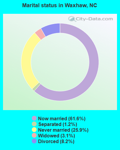
- Never married: 25.9%
- Now married: 61.6%
- Separated: 1.2%
- Widowed: 3.1%
- Divorced: 8.2%
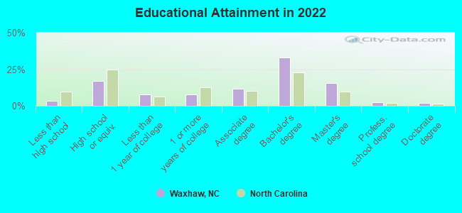
For population 25 years and over in Waxhaw:
- High school or higher: 96.7%
- Bachelor's degree or higher: 53.8%
- Graduate or professional degree: 19.2%
- Unemployed: 4.8%
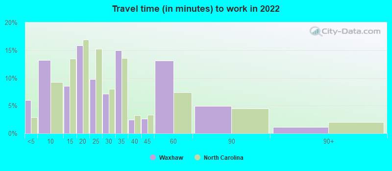
- Mean travel time to work (commute): 22.7 minutes
| Here: | 9.3 |
| North Carolina average: | 11.7 |
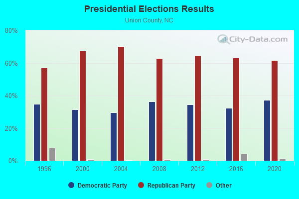
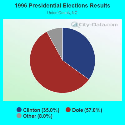
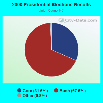

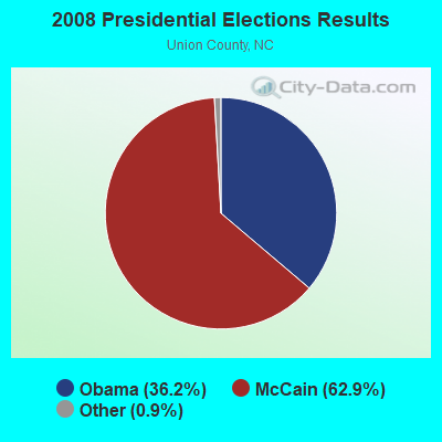
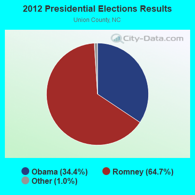
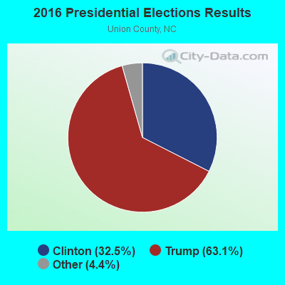
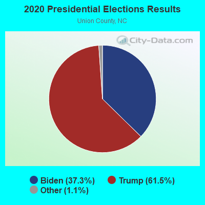
Graphs represent county-level data. Detailed 2008 Election Results
Religion statistics for Waxhaw, NC (based on Union County data)
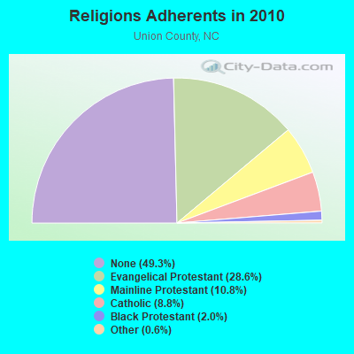
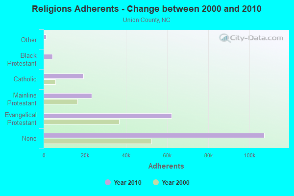
| Religion | Adherents | Congregations |
|---|---|---|
| Evangelical Protestant | 62,089 | 156 |
| Mainline Protestant | 23,392 | 56 |
| Catholic | 19,205 | 1 |
| Black Protestant | 4,364 | 23 |
| Other | 1,222 | 5 |
| None | 107,171 | - |
Food Environment Statistics:
| This county: | 1.31 / 10,000 pop. |
| North Carolina: | 2.05 / 10,000 pop. |
| This county: | 0.05 / 10,000 pop. |
| State: | 0.14 / 10,000 pop. |
| Union County: | 1.09 / 10,000 pop. |
| State: | 0.92 / 10,000 pop. |
| Union County: | 2.50 / 10,000 pop. |
| North Carolina: | 4.75 / 10,000 pop. |
| This county: | 4.73 / 10,000 pop. |
| North Carolina: | 7.57 / 10,000 pop. |
| Union County: | 7.6% |
| State: | 9.8% |
| Union County: | 26.8% |
| State: | 28.3% |
| This county: | 16.2% |
| State: | 15.6% |
Health and Nutrition:
| Waxhaw: | 52.6% |
| North Carolina: | 48.9% |
| This city: | 52.5% |
| North Carolina: | 46.1% |
| Waxhaw: | 28.6 |
| State: | 28.8 |
| Waxhaw: | 19.9% |
| North Carolina: | 20.7% |
| Waxhaw: | 8.9% |
| North Carolina: | 10.7% |
| This city: | 6.8 |
| North Carolina: | 6.8 |
| Waxhaw: | 34.2% |
| State: | 33.7% |
| Waxhaw: | 60.8% |
| North Carolina: | 55.8% |
| Waxhaw: | 82.6% |
| North Carolina: | 79.7% |
More about Health and Nutrition of Waxhaw, NC Residents
| Local government employment and payroll (March 2022) | |||||
| Function | Full-time employees | Monthly full-time payroll | Average yearly full-time wage | Part-time employees | Monthly part-time payroll |
|---|---|---|---|---|---|
| Police Protection - Officers | 33 | $165,515 | $60,187 | 0 | $0 |
| Other Government Administration | 17 | $87,556 | $61,804 | 0 | $0 |
| Streets and Highways | 15 | $72,208 | $57,766 | 0 | $0 |
| Other and Unallocable | 12 | $58,099 | $58,099 | 12 | $5,594 |
| Parks and Recreation | 9 | $76,734 | $102,312 | 0 | $0 |
| Financial Administration | 5 | $31,959 | $76,702 | 0 | $0 |
| Police - Other | 3 | $19,853 | $79,412 | 0 | $0 |
| Totals for Government | 94 | $511,924 | $65,352 | 12 | $5,594 |
Waxhaw government finances - Expenditure in 2021 (per resident):
- Construction - Police Protection: $2,714,000 ($120.45)
- Current Operations - Liquor Stores: $3,337,000 ($148.09)
Financial Administration: $2,106,000 ($93.46)
Housing and Community Development: $1,830,000 ($81.21)
Solid Waste Management: $1,374,000 ($60.98)
Regular Highways: $1,237,000 ($54.90)
Parks and Recreation: $783,000 ($34.75)
Police Protection: $329,000 ($14.60)
Central Staff Services: $148,000 ($6.57)
- General - Interest on Debt: $116,000 ($5.15)
- Intergovernmental to Local - Other - Health - Other: $12,000 ($0.53)
- Other Capital Outlay - Financial Administration: $599,000 ($26.58)
Regular Highways: $423,000 ($18.77)
Police Protection: $207,000 ($9.19)
Parks and Recreation: $37,000 ($1.64)
- Total Salaries and Wages: $655,000 ($29.07)
Waxhaw government finances - Revenue in 2021 (per resident):
- Charges - Other: $1,062,000 ($47.13)
Miscellaneous Commercial Activities: $170,000 ($7.54)
Parks and Recreation: $16,000 ($0.71)
- Local Intergovernmental - General Local Government Support: $4,406,000 ($195.54)
- Miscellaneous - Sale of Property: $1,454,000 ($64.53)
General Revenue - Other: $14,000 ($0.62)
Interest Earnings: $8,000 ($0.36)
- Revenue - Liquor Stores: $3,952,000 ($175.39)
- State Intergovernmental - Other: $703,000 ($31.20)
- Tax - Property: $8,781,000 ($389.70)
Alcoholic Beverage Sales: $444,000 ($19.70)
Other License: $393,000 ($17.44)
Occupation and Business License - Other: $273,000 ($12.12)
| Businesses in Waxhaw, NC | ||||
| Name | Count | Name | Count | |
|---|---|---|---|---|
| Ace Hardware | 1 | Lowe's | 1 | |
| Advance Auto Parts | 1 | MasterBrand Cabinets | 1 | |
| AutoZone | 1 | McDonald's | 1 | |
| Burger King | 1 | Papa John's Pizza | 1 | |
| CVS | 4 | Quiznos | 1 | |
| Domino's Pizza | 1 | Subway | 1 | |
| FedEx | 2 | U-Haul | 2 | |
| Goodwill | 1 | UPS | 1 | |
| H&R Block | 1 | Walgreens | 1 | |
Strongest AM radio stations in Waxhaw:
- WAGL (1560 AM; daytime; 50 kW; LANCASTER, SC; Owner: PALMETTO BROADCASTING SYSTEM, INC.)
- WBT (1110 AM; 50 kW; CHARLOTTE, NC; Owner: JEFFERSON-PILOT COMMUNICATNS CO. OF NORTH CAROLINA)
- WNOW (1030 AM; daytime; 9 kW; MINT HILL, NC; Owner: CHARLOTTE METRO RADIO, INC.)
- WCEO (840 AM; daytime; 50 kW; COLUMBIA, SC; Owner: EASTERN BROADCASTING GROUP, INC.)
- WDEX (1430 AM; 2 kW; MONROE, NC; Owner: NEW LIFE COMMUNITY TEMPLE OF FAITH, INC.)
- WIXE (1190 AM; daytime; 2 kW; MONROE, NC; Owner: MONROE BROADCASTING COMPANY, INC.)
- WBAJ (890 AM; daytime; 50 kW; BLYTHEWOOD, SC; Owner: FAMILY FIRST)
- WLTC (1370 AM; 20 kW; GASTONIA, NC)
- WBCU (1460 AM; 50 kW; UNION, SC)
- WFNZ (610 AM; 5 kW; CHARLOTTE, NC; Owner: INFINITY RADIO SUBSIDIARY OPERATIONS INC.)
- WGFY (1480 AM; 10 kW; CHARLOTTE, NC; Owner: ABC, INC.)
- WCGC (1270 AM; 10 kW; BELMONT, NC; Owner: WHVN, INC.)
- WHKY (1290 AM; 50 kW; HICKORY, NC; Owner: LONG COMMUNICATIONS, LLC.)
Strongest FM radio stations in Waxhaw:
- WWMG (96.1 FM; SHELBY, NC; Owner: CLEAR CHANNEL BROADCASTING LICENSES, INC.)
- WKKT (96.9 FM; STATESVILLE, NC; Owner: CAPSTAR TX LIMITED PARTNERSHIP)
- WRCM (91.9 FM; WINGATE, NC; Owner: COLUMBIA BIBLE COLLEGE BROADCASTING CO)
- WRHM (107.1 FM; LANCASTER, SC; Owner: OUR THREE SONS BROADCASTING, LLP)
- WSOC-FM (103.7 FM; CHARLOTTE, NC; Owner: INFINITY RADIO SUBSIDIARY OPERATIONS INC.)
- WRFX-FM (99.7 FM; KANNAPOLIS, NC; Owner: CAPSTAR TX LIMITED PARTNERSHIP)
- WSSS (104.7 FM; CHARLOTTE, NC; Owner: INFINITY RADIO SUBSIDIARY OPERATIONS INC.)
- WLNK (107.9 FM; CHARLOTTE, NC; Owner: JEFFERSON-PILOT COMMUNICATIONS COMPANY OF NORTH CAROLINA)
- WNSC-FM (88.9 FM; ROCK HILL, SC; Owner: SOUTH CAROLINA EDUCATIONAL TV COMMISSION)
- WPEG (97.9 FM; CONCORD, NC; Owner: INFINITY RADIO SUBSIDIARY OPERATIONS INC.)
- WFAE (90.7 FM; CHARLOTTE, NC; Owner: UNIVERSITY RADIO FOUNDATION, INC.)
- WNKS (95.1 FM; CHARLOTTE, NC; Owner: INFINITY RADIO SUBSIDIARY OPERATIONS INC.)
- WBAV-FM (101.9 FM; GASTONIA, NC; Owner: INFINITY RADIO SUBSIDIARY OPERATIONS INC.)
- WLYT (102.9 FM; HICKORY, NC; Owner: CAPSTAR TX LIMITED PARTNERSHIP)
- WNMX-FM (106.1 FM; WAXHAW, NC; Owner: GHB OF WAXHAW, INC)
- WRBK (90.3 FM; RICHBURG, SC; Owner: RICHBURG EDUCATIONAL BROADCASTERS, INC.)
- W232AX (94.3 FM; ROCK HILL, SC; Owner: OUR THREE SONS BROADCASTING, LLP)
- WYFQ-FM (93.5 FM; WADESBORO, NC; Owner: BIBLE BROADCASTING NETWORK, INC.)
- WXRC (95.7 FM; HICKORY, NC; Owner: PACIFIC BROADCASTING GROUP, INC.)
- WTHZ (94.1 FM; LEXINGTON, NC; Owner: DAVIDSON COUNTY BROADCASTING CO, INC)
TV broadcast stations around Waxhaw:
- WAFF (Channel 48; HUNTSVILLE, AL; Owner: RAYCOM AMERICA, INC.)
- WSOC-TV (Channel 9; CHARLOTTE, NC; Owner: WSOC-TV HOLDINGS, INC.)
- WGTB-LP (Channel 28; CHARLOTTE, NC; Owner: VICTORY CHRISTIAN CENTER, INC.)
- WBTV (Channel 3; CHARLOTTE, NC; Owner: JEFFERSON-PILOT COMMUNICATIONS/WBTV, INC.)
- WTVI (Channel 42; CHARLOTTE, NC; Owner: CHARLOTTE-MECKLENBURG PUBLIC BROADCASTING AUTHORITY)
- WCCB (Channel 18; CHARLOTTE, NC; Owner: NORTH CAROLINA BROADCASTING PARTNERS)
- WCNC-TV (Channel 36; CHARLOTTE, NC; Owner: WCNC-TV, INC.)
- WJZY (Channel 46; BELMONT, NC; Owner: WJZY-TV, INC.)
- WWWB (Channel 55; ROCK HILL, SC; Owner: WWWB-TV, INC.)
- WUNG-TV (Channel 58; CONCORD, NC; Owner: UNIVERSITY OF NORTH CAROLINA)
- WNSC-TV (Channel 30; ROCK HILL, SC; Owner: SOUTH CAROLINA EDUCATIONAL TV COMMISSION)
- W25BR (Channel 25; CHARLOTTE, NC; Owner: WORD OF GOD FELLOWSHIP, INC.)
- W52CW (Channel 52; CHARLOTTE, NC; Owner: TRINITY BROADCASTING NETWORK)
- WAXN (Channel 64; KANNAPOLIS, NC; Owner: WSOC-TV HOLDINGS, INC.)
- W34BN (Channel 34; CHARLOTTE, NC; Owner: THREE ANGELS BROADCASTING NETWORK)
- WOLO-TV (Channel 25; COLUMBIA, SC; Owner: SOUTH CAROLINA BROADCASTING PARTNERS)
- WLTX (Channel 19; COLUMBIA, SC; Owner: PACIFIC AND SOUTHERN COMPANY, INC.)
- National Bridge Inventory (NBI) Statistics
- 18Number of bridges
- 151ft / 45.8mTotal length
- 64,580Total average daily traffic
- 4,186Total average daily truck traffic
- 129,160Total future (year 2040) average daily traffic
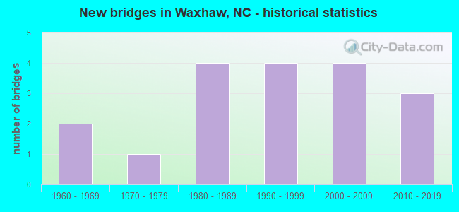
- New bridges - historical statistics
- 21960-1969
- 11970-1979
- 41980-1989
- 41990-1999
- 42000-2009
- 32010-2019
FCC Registered Antenna Towers: 104 (See the full list of FCC Registered Antenna Towers)
FCC Registered Broadcast Land Mobile Towers: 16 (See the full list of FCC Registered Broadcast Land Mobile Towers in Waxhaw, NC)
FCC Registered Microwave Towers: 16 (See the full list of FCC Registered Microwave Towers in this town)
FCC Registered Maritime Coast & Aviation Ground Towers: 3 (See the full list of FCC Registered Maritime Coast & Aviation Ground Towers)
FCC Registered Amateur Radio Licenses: 338 (See the full list of FCC Registered Amateur Radio Licenses in Waxhaw)
FAA Registered Aircraft Manufacturers and Dealers: 2 (See the full list of FAA Registered Manufacturers and Dealers in Waxhaw)
FAA Registered Aircraft: 73 (See the full list of FAA Registered Aircraft)
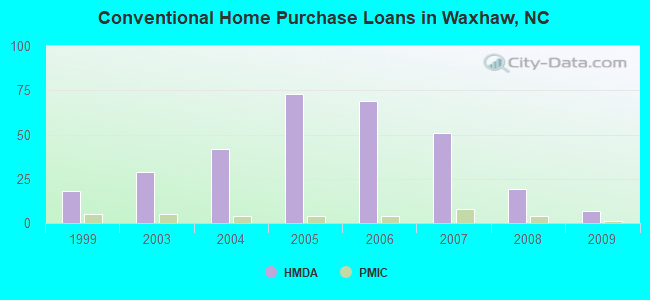
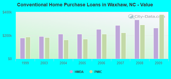
| Home Mortgage Disclosure Act Aggregated Statistics For Year 2009 (Based on 1 partial tract) | ||||||||||
| A) FHA, FSA/RHS & VA Home Purchase Loans | B) Conventional Home Purchase Loans | C) Refinancings | D) Home Improvement Loans | F) Non-occupant Loans on < 5 Family Dwellings (A B C & D) | ||||||
|---|---|---|---|---|---|---|---|---|---|---|
| Number | Average Value | Number | Average Value | Number | Average Value | Number | Average Value | Number | Average Value | |
| LOANS ORIGINATED | 5 | $176,370 | 7 | $263,457 | 36 | $217,377 | 1 | $74,580 | 2 | $172,990 |
| APPLICATIONS APPROVED, NOT ACCEPTED | 0 | $0 | 1 | $248,940 | 2 | $258,230 | 0 | $0 | 0 | $0 |
| APPLICATIONS DENIED | 1 | $140,820 | 1 | $306,690 | 12 | $230,081 | 1 | $82,840 | 1 | $100,090 |
| APPLICATIONS WITHDRAWN | 1 | $136,930 | 1 | $439,730 | 7 | $248,260 | 0 | $0 | 0 | $0 |
| FILES CLOSED FOR INCOMPLETENESS | 0 | $0 | 0 | $0 | 2 | $243,135 | 0 | $0 | 0 | $0 |
Detailed HMDA statistics for the following Tracts: 0210.02
| Private Mortgage Insurance Companies Aggregated Statistics For Year 2009 (Based on 1 partial tract) | ||||
| A) Conventional Home Purchase Loans | B) Refinancings | |||
|---|---|---|---|---|
| Number | Average Value | Number | Average Value | |
| LOANS ORIGINATED | 1 | $378,690 | 1 | $167,780 |
| APPLICATIONS APPROVED, NOT ACCEPTED | 0 | $0 | 1 | $210,550 |
| APPLICATIONS DENIED | 0 | $0 | 0 | $0 |
| APPLICATIONS WITHDRAWN | 0 | $0 | 0 | $0 |
| FILES CLOSED FOR INCOMPLETENESS | 0 | $0 | 0 | $0 |
Detailed PMIC statistics for the following Tracts: 0210.02
2002 - 2018 National Fire Incident Reporting System (NFIRS) incidents
- Fire incident types reported to NFIRS in Waxhaw, NC
- 41642.2%Structure Fires
- 39840.4%Outside Fires
- 989.9%Other
- 737.4%Mobile Property/Vehicle Fires
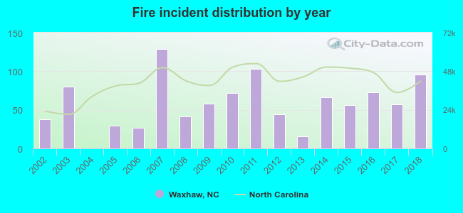 Based on the data from the years 2002 - 2018 the average number of fire incidents per year is 58. The highest number of fires - 129 took place in 2007, and the least - 0 in 2004. The data has an increasing trend.
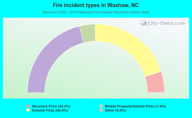 When looking into fire subcategories, the most incidents belonged to: Structure Fires (42.2%), and Outside Fires (40.4%).
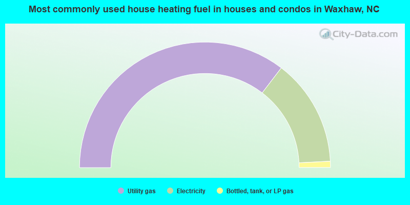
- 70.8%Utility gas
- 27.6%Electricity
- 1.6%Bottled, tank, or LP gas
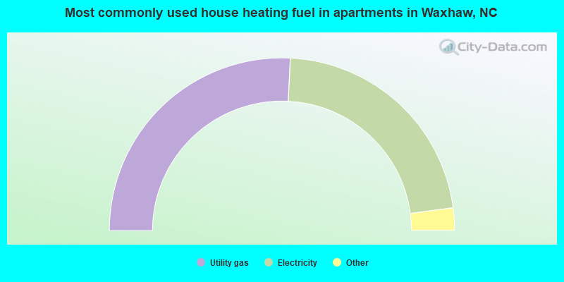
- 51.6%Utility gas
- 44.3%Electricity
- 3.5%Bottled, tank, or LP gas
- 0.6%Wood
Waxhaw compared to North Carolina state average:
- Median household income above state average.
- Median house value above state average.
- Unemployed percentage significantly below state average.
- Black race population percentage significantly above state average.
- Hispanic race population percentage significantly above state average.
- Median age significantly below state average.
- Foreign-born population percentage significantly above state average.
- Renting percentage significantly below state average.
- Length of stay since moving in significantly below state average.
- Number of rooms per house above state average.
- House age significantly below state average.
- Number of college students above state average.
- Percentage of population with a bachelor's degree or higher above state average.
Waxhaw on our top lists:
- #18 on the list of "Top 101 cities with most building permits per 10,000 residents (population 5,000+)"
- #50 on the list of "Top 100 cities with newest houses (pop. 5,000+)"
- #63 on the list of "Top 101 cities with the largest city-data.com crime index increase from 2002 to 2012 (population 5,000+)"
- #79 on the list of "Top 101 cities with largest percentage of males in occupations: sales and related occupations (population 5,000+)"
- #80 on the list of "Top 101 cities with the highest number of murders per 100,000 residents, excludes tourist destinations and others with a lot of outsiders visiting based on city industries data (population 5,000+)"
- #80 on the list of "Top 100 fastest growing cities from 2000 to 2014"
- #96 on the list of "Top 101 cities with the most residents born in Barbados (population 500+)"
- #101 on the list of "Top 101 cities with the most residents born in South Africa (population 500+)"
- #3 on the list of "Top 101 counties with the largest decrease in the number of births per 1000 residents 2000-2006 to 2007-2013 (pop 50,000+)"
- #20 on the list of "Top 101 counties with the lowest ground withdrawal of fresh water for public supply (pop. 50,000+)"
- #44 on the list of "Top 101 counties with the lowest percentage of residents that drank alcohol in the past 30 days"
- #47 on the list of "Top 101 counties with the highest percentage of residents that keep firearms around their homes"
- #70 on the list of "Top 101 counties with the lowest percentage of residents that smoked 100+ cigarettes in their lives"

|
|
Total of 614 patent applications in 2008-2024.